
Abstract
Geoinformatics education is a key factor for sustainable development of geo-spatial sciences and industries. There have been a variety of educational activities focusing on education and training, technology transfer, and capability building in photogrammetry, remote sensing, and spatial information science, together known as Geoinformatics. Geoinformatics education is an essential mission and even determinant in the ISPRS society. The paper discusses key issues in Geoinformatics education. It reviews educational activities from the ISPRS perspective and summarizes lessons learned from these actions. A vision towards future trends of Geoinformatics education in the ISPRS is provided.
1. Introduction
Scientific and technological advances are penetrating all fields of Geoinformatics including photogrammetry, remote sensing, and spatial information sciences (P&RS&SIS), making them better tools to serve for social progress, economic growth, and environmental sustainability. Photogrammetry is the art, science, and technology for making reliable measurements from non-contact images, image sequences, and point clouds. Remote sensing refers to the use of methods and systems enabling to obtain and process remotely sensed observations of the Earth derived from air- and space-borne sensors. Spatial information science involves the modeling, management, analysis, integration, and visualization of spatio-temporal data. Recently, more sophisticated cameras and sensors have been employed in photogrammetry and remote sensing to enhance data acquisition capabilities. New theories and methodologies are being applied for image interpretation and information extraction. Emerging technologies such as cloud computing, large scale array databases, and the Internet of Things expand the reach of spatial information science, allowing us to answer previously unanswerable questions that often traverse diverse scientific domains (Yue et al. Citation2016a). Their applications are varied and being extensively implemented in the field of urban and regional planning, industrial manufacturing, environmental monitoring, etc.
Geoinformatics education acts as a bridge between these sci-tech advancements and practical applications. It constructs the foundation of the bridge mainly by producing a well-educated scientific workforce. The cutting-edge technologies are vertically transferred to new manufacturing sectors through such a well-trained labor force of individuals deeply knowledgeable across P&RS&SIS disciplines. New technologies produce global efficacy through their horizontal transfer among governments, institutions, and organizations. The transference is often mono-directional, going from highly to less developed countries in the form of regional capacity building. Since its foundation in 1910, the International Society for Photogrammetry and Remote Sensing (ISPRS) has identified Geoinformatics education and training as an essential activity in the society. It has realized the importance of education and training to balance regional development of P&RS&SIS among its member countries. Continuous efforts have been made, especially in the less developed countries, to correct the imbalance in order to achieve global co-development. Although the ISPRS has been through several evolutions of its structure, the educational theme has always been one of its key concerns.
This scientific and technological progress is not only transferred into industrial circles, but is also absorbed by education fields. Progress, especially in information and communication technology (ICT), inspires innovations in education and teaching, which feed back to the development of scientific research and industrial applications in P&RS&SIS. ICT accelerates the teaching and learning process, enhances accessibility of education resources, emancipates students from a stationary learning environment, and finally leads to the reshaping of the conventional education mode. For example, the development of E-delivery of education services enriches teaching methods and learning experience. As increasing educational resources and programs have been launched, there is a need to review recent developments in Geoinformatics education, evaluate existing approaches and projects, and recommend future activities and topics within the ISPRS on education and outreach.
The remainder of the paper is structured as follows. Section 2 describes the issues, including education and training, technology transfer, and capacity building in Geoinformatics. Section 3 reviews educational activities from the ISPRS perspective. Some initiatives and programs carried out by ISPRS are discussed in this section. Lessons learned from these activities are summarized in Section 4. A vision for future directions of Geoinformatics education in the ISPRS is provided in Section 5. Finally, Section 6 concludes the paper.
2. Key issues
2.1. Education and training
The motivation for Geoinformatics education and training emanates from multiple factors. One of the most important factors is the demand for economic sustainable development. In recent years, Geoinformatics industries have developed rapidly. For example, it is estimated that the geo-spatial data and services generate $1.6 trillion annually in the United States alone (OGC Citation2015). In China, the annual productivity value of Geoinformatics is estimated to keep growing at the average rate of 25% in years to come (Li, Gong, and Yue Citation2014). Such a large market and economic engine require a strong support from Geoinformatics education, which provides them with a large number of professional workers and technological and scientific innovations. A strong Geoinformatics education system gives the promise of continued economic growth.
Another factor for Geoinformatics education development comes from the strong request of such fields as environmental sustainment, soil science, and climate science. The integration of multiple scientific domains and the absorption of frontier technologies redefine the problem-solving capabilities of Geoinformatics (Yue et al. Citation2015a). Many scenarios that were previously not well resolved find fungible and feasible solutions in Geoinformatics fields. Such scenarios include assessment of global environment change, planning and responses to natural hazards, and management of global/regional ecological risks. For example, Wan et al. (Citation2014) provide a global flood disaster community cyber-infrastructure that integrates cloud computing services, geo-spatial data infrastructures, crowd-sourcing technology, and location-based event visualization to collect, manage, analyze, and visualize several global flood databases.
Favorable societal and political factors such as the increase in college education also propel the development of Geoinformatics education. The purpose of college education has changed from educating elite groups into producing skilled workers to some extent. For example, in China over 200 universities offer academic programmes in Geoinformatics, which produce nearly 15,000 graduate students in the field each year (Li, Gong, and Yue Citation2014). In addition, individual ambition contributes to the prosperity of Geoinformatics education. To improve employment competitiveness, workers seek higher educational accomplishments to enable them to qualify for high-salary jobs.
2.2. Technology transfer and capacity building
In the era of globalization, Geoinformatics education is no longer a matter of a single institution or a single country. International technology transfer has become a common phenomenon among governments, institutions, and organizations, including dispatching experts, investing money, and establishing transnational corporations. With international technology transfer, capacity development ensues in countries that are economically and technologically less developed. According to the definition of the 1992 United Nations Conference on Environment and Development, capacity-building comprises human, scientific, technological, organizational, and institutional resources and capabilities (UNCED Citation1992). Efforts are primarily focused on human, institutional, and organizational development. Some internationally oriented education programmes in Geoinformatics have been initiated by the International Institute for Geo-Information Sciences and Earth Observation (ITC), aimed at capacity building, institutional and organizational strengthening in less developed countries (Molenaar Citation2004). Other forms of capacity building include data dissemination, software and hardware donation, curriculum development, technology tutorial sharing, and training of teaching and technical staff.
3. Existing educational activities – An ISPRS perspective
An important task of ISPRS is to support, promote, and stimulate Geoinformatics education and training, computer-assisted distance learning, methodology and curriculum development, technology transfer and capacity development, and the promotion of the profession to young people. A number of educational activities have been conducted by the ISPRS in the last few years. They serve as a valuable reference for reviewing existing approaches to promote Geoinformatics education. These activities are classified into six categories: Web-based resource sharing, E-delivery of education services, international collaborative education programs, regional cooperation activities, profession development for young people, and capacity development.
3.1. Web-based resource sharing
With the maturity of Web Service technology, geo-spatial resources (e.g. geo-spatial data, services, workflows, models) are increasingly available and accessible in the distributed Web environment. These open geographic information resources facilitate Web-based sharing for education, research, and collaboration (Gong et al. Citation2009). An increasing quantity of geo-spatial resources are provided by ISPRS members, such as on- or offline test data-sets (close-range images, aerial images, satellite images, CityGML, etc.), online algorithms provided by Web Services (e.g. GeoPW), teaching materials and tutorials, open source software (e.g. GRASS GIS, computer vision source code, geodetic software, air-borne LIDAR data processing and analysis tools). Furthermore, GeoSquare, a Web-based resource sharing platform that integrates distributed geo-spatial data, service, and infrastructure, is publically available (Gong et al. Citation2012).
To make better use of these Web-based resources and platforms, the ISPRS and the State Key Laboratory of Information Engineering in Surveying, Mapping and Remote Sensing (LIESMARS) of Wuhan University, have developed a new curriculum, named “Geospatial Service Platform for Education and Research”, which has been held during the ISPRS Summer School in May 2014 at Wuhan University, China. The course shares cutting-edge achievements of a geo-spatial service platform with students from different countries, and trains them with online tools from the platform for geo-spatial data processing and scientific research (Yue et al. Citation2010). The content of the course includes basic concepts of geo-spatial Web services, service-oriented architecture, geoprocessing modeling and chaining, and problem-solving using geo-spatial services. In particular, the course offers a geo-spatial service platform for hands-on practice. After the course is finished, students will have learned how to use online service platforms for geo-spatial resource sharing, problem-solving, capacity building, and knowledge transfer (Gong et al. Citation2014).
3.2. E-delivery of education services
The ways that Geoinformatics education is delivered are not limited to classes, workshops, summer schools, and tradition online learning. It is imperative to adopt new teaching and learning methods in order to deliver Geoinformatics knowledge. With the advancements in computer systems and Web technologies, computer aided teaching and training become more attractive, diverse, and interactive. New trends in E-learning have gained great momentum over the last few years including Massive Open Online Courses (MOOCs) and mobile applications for Geoinformatics education. A number of elite universities like Stanford, MIT, Carnegie Mellon have begun to offer online version of their courses to the public either free or paid. It is then necessary to investigate the role of E-learning in modern-day education and training and develop, evaluate, and recommend the E-learning methodology for Geoinformatics. Despite the growing availability of Web-based educational products and E-learning courses, it is not easy to find appropriate educational material. Vyas and Koenig (Citation2014) present some best practise examples of MOOCs in Geoinformatics education. Teo et al. (Citation2014) analyze and maintain a list of Apps related to geo-spatial field.
An ISPRS Scientific Initiative on “Assessment of Learning Pedagogy in GeoInformatics” has been done. This research is an attempt to study the prevailing pedagogy of learning, and to discuss the issues and challenges to these theories and practices for academia (institutions), students, and the geo-spatial industry. The emphasis is placed on the developments and innovations taking place, and on the coping mechanism. It discusses the issue of innovation in technology (both communications technology and geo-spatial technology), the knowledge and skill developed through various methods of learning, where the education emphasis on fundamental principles and training is largely practical and hands-on. Overall the project aims to assess various theories and methods of evaluation (rating) of learning within education, and the systems and structures of it for Geoinformatics.
Several workshops were organized to promote innovative learning methods, such as E-learning and Web-based applications for education services, technology transfer, and capacity development. For example, the workshop entitled “Innovative-Learning Tools 2013”, focused on strategies for capacity building, issues and challenges for education, open source developments, E-learning concepts, tools, and techniques. A brainstorming workshop was organized to discuss the status of the E-learning experience in India, and the role of industry and institutions. In addition, the ISPRS cooperated with other institutions to hold joint workshops on Geoinformatics education, such as the “Education in GIS” workshop jointly organized with DDGI (Deutscher Dachverband für Geoinformation).
3.3. International collaborative education programs
ISPRS cooperates with other international geo-spatial societies to improve education and training in the Geoinformatics sciences. ISPRS participates in CEOS (Committee for Earth Observation Satellites) WGEdu (Working Group on Education), the CEOS Capacity Building Module 1 (on education and training), and GEO (Group on Earth Observations), and cooperates with the ICA (International Cartographic Association), the AARS (Asian Association on Remote Sensing), the African Association of Remote Sensing of the Environment (AARSE), and so on. Their collaborative forms include holding joint workshops, funding summer schools, co-organizing regional activities, and co-developing programs in education, training, and capacity building. ITC is one of the best examples of international education in the field of geo-information science and earth observation. In the future, Wuhan University intends to develop an International Geoinformatics School to promote its international collaborative education programmes.
ISPRS further strengthens its association and cooperation with international and regional institutions and organizations concerned with geo-spatial disciplines. Projects or studies are conducted including the development of the core curricula and educational modules for educationally underdeveloped areas. An ISPRS grant for scientific initiatives has been awarded in 2014, to develop a curriculum for the African Geospatial Sciences Institute (AGSI). The objective is to draft a curriculum based on the requirements of the region. The project involves ISPRS Working Groups, ISPRS Regional Members, cognate societies and local organizations. They have developed a framework for the curriculum and identified a draft set of modules and a number of issues (Dowman and Labbassi Citation2014).
3.4. Regional development
Regional activities are emerging, where universities and other organizations can support each other in the development of seminars, tutorials, workshops, courses, and training programmes. Promotion of regional cooperation and regional capacity development in Geoinformatics may initiate and develop regional action for capacity building and knowledge dissemination, and mutual support for education programs and regional institutes. For example, the ISPRS 3S − Summer Students Seminar series emerged in recent years. The summer seminars are joint events rotating among Moscow State University of Geodesy and Cartography (MIIGAiK), Siberian State University of Geosystems and Technologies (SSUGT – former SSGA), Wuhan University and Tongji University. Topics of the 3rd edition, at MIIGAiK, Moscow in summer of 2012 were “InSAR and Urban 3D”. The 4th edition, held at the SSUGT, Novosibirsk, dealt with “InSAR and Web GIS”. Now the 3S seminar has attracted many students beyond these four institutions.
3.5. Promotion of the profession to young people
It is important to promote sharing and exchange of information about academic positions and opportunities for young scholars within the ISPRS, and international mobility for young researchers. Activities include summer schools, workshops, student sessions, and free satellite data distribution. To support capacity building in less developed countries, priority is often given to organizations and institutions from developing countries to host summer schools. For example, the 8−12th ISPRS Summer Schools were held respectively in Thailand, Indonesia, Ethiopia, China, and Myanmar from 2012 to 2014. It is worth mentioning that the 11th ISPRS Summer School was held jointly with the 2014 Geoinformatics Summer Camp and the 5th ISPRS 3S – Summer Students Seminar at Wuhan University, Wuhan, China, which attracted over 200 attendees from 13 countries. In addition, Wuhan University continued holding international Geoinformatics Summer Schools in 2015 and 2016 respectively, to train young scholars in cutting-edge geo-spatial Big Data technologies and techniques.
It has been found that a student lecture session during the symposium/workshop is also helpful. In the Commission VI Mid-Term Symposium held in Wuhan, China, 2014, the half-day student lecture session included an oral session for student representatives to provide a brief introduction about their universities, student activities and on-going student research, a poster session for students to interactively present their on-going research among other students and young scientists, and guest experts to share their knowledge and ideas regarding the technical presentations. Similar events and student or young professional-related activities were also organized in different ISPRS meetings and other international conferences, symposiums, and workshops. In 2013 and 2014, two research opportunities were initiated to provide free satellite data to ISPRS-affiliated researchers and students. The two initiatives awarded archived and/or new data acquisition requests (DAR) DMCii and FORMOSAT-2 data to 15 selected proposals worldwide, covering different topics of research and applications of satellite remote sensing.
Another important part of youth activities in ISPRS is the Student Consortium (SC), which was established at the XXI ISPRS Congress in Istanbul, Turkey in 2004. The main purpose of the SC is to link students, young researchers, and professionals from different countries and provide a platform for exchange of information, to organize student-specific events and other actions integrating young people more effectively into ISPRS. The SC operates its own website, mailing list and social media groups. Currently, the SC has more than 1200 registered members from around 100 countries. There are more than 4000 “followers” of the ISPRS SC groups in different social media. The SC board members have been actively helping organizing ISPRS summer schools, workshops and other ISPRS-related events. They also participated in these events and acted as seeds to attract more young researchers to join in ISPRS activities. In addition, four issues of the ISPRS SC Newsletter are published every year by the SC since 2007.
3.6. Capacity development
The ISPRS promotes and stimulates technology transfer and capacity development by initiating and organizing seminars, tutorials, and workshops with special consideration for the needs of under-developed and developing countries. For example, a workshop on “Advanced Applications of Geospatial Technology” was co-organized by the ISPRS in Nepal on 12−13 September 2013, to address knowledge exchange of advanced geo-spatial technologies and highlight the potential of some of Nepalese institutions in the international arena. A Seminar/Workshop on “Innovative Geo-spatial Technologies” was organized in Nanchang, China in June 2015. The ISPRS was also involved in the EU FP7 IASON and EOPOWER projects, organization of the workshop “The future of Earth Observation activities in the wider Balkan area − An official GEO event”, and development of a new MSc programme in Pristina, Kosovo.
Sometimes ISPRS members propose plans or strategies for Geoinformatics capacity building on the request of governmental bodies concerned with P&RS&SIS, land survey, urban planning, and other relevant disciplines. Kumar et al. (Citation2014) from the Indian Institute of Remote Sensing studied the existing model syllabi of the All India Council for Technical Education, and proposed a geo-spatial technology curriculum for bachelor and master’s programmes. The Zamani group’s (University of Cape Town) capacity building activities over the past few years included field training for laser scanning and Heritage documentation, training in data processing of laser-scan data, and a 5-day course in “GIS and data acquisition for heritage documentation”.
In addition, the White Elephant Club is a recognized ISPRS ad hoc Committee on “Knowledge Transfer”, focusing on supporting the technology transfer activities of Commission VI and initiating activities for bridging the gap between generations, and fostering events to support young scientists and students. White Elephant sessions are often organized in conjunction with ISPRS Congresses, symposia, and other related meetings. For example, during the 33rd and 34th ACRS, White Elephant Club members gave lectures on journal paper/thesis/proposal writing, and presentation techniques to young researchers.
Besides building capacity for less developed ISPRS member countries, technology transfer also bridges the gap between education and industry/business. Commission VI endeavors to develop effective technology transfer strategies to support the fast developing Geoinformatics industry and education. Tsai and Chen (Citation2014) investigated the current status of the geo-spatial industry in Taiwan, and identified the challenges of geo-spatial education and technology transfer. They suggested that short-term programs (e.g. capacity-building workshops and training courses) and “certificate programs” could be developed to cope with potential challenges.
4. Lesssons learnt
A great number of productive and well tested activities have been conducted in the past several years, significantly promoting and stimulating education, technology transfer, and capacity development within P&RS&SIS. At the same time, there were several challenges encountered in previous activities. This section provides some lessons we have learnt from existing approaches in Geoinformatics education.
4.1. Open geo-spatial resources
The open resource movement promotes and accelerates scientific research, technology innovations, and adoption of standards. It is also of great value to the capacity development considering the resource limitations encountered by the majority of developing countries. Therefore, continued support for open source is crucial to the success of our fields. ISPRS maintains a list of geo-spatial resources on its websites for education, research and collaboration, including datasets, tutorials, free software, and source code. Many online algorithms, geoprocessing models, and Web services have been supplemented by ISPRS members. The use of these open geo-spatial resources on the Web can certainly enrich teaching, learning, and research. However, statistics show that these online sources are not as widely used as had been expected. This may be because the quantity of shared data is limited, and some tools are not easy to use. It has been suggested that Web 2.0 and crowdsourcing technologies can be employed to address the issue of resource limitations. The linked data technology could also help to facilitate the discovery of these resources (Yue et al. Citation2016b). The standardization of compiled documents (or manuals) on the shared tools is recommended. Another concern of users may be whether the quality of these products is guaranteed or not. Thus, the necessary metadata and comments from users will be beneficial for the shared resources.
4.2. E-learning methodology
Recent trends show a significant transition towards E-learning, shown by the growing number of education apps and online platforms such as MOOCs. This learning pedagogy is particularly well suited to serve the needs of Geoinformatics practitioners who lack theoretical knowledge and technical skills (Elsner Citation2005). The large number of followers demonstrates the success of these modern teaching methods. However, there are many factors that discourage public responses to the E-learning mechanism, including possessiveness, threat of exposure, absence of lab and hands-on opportunities, as well as lack of social and institutional recognition of E-learning methods. Many students experienced frustration when participating in online courses due to slow Internet connections. In addition, the wide range of time zones that participants live in, impedes real-time group discussions. Thus, additional efforts are required, including “frequently asked questions” pages, “how-to” instructions, online learning communities or discussion forums, expectations on participation, and etiquette guidelines.
4.3. Summer schools
The ISPRS Summer School continues the very successful tradition started by the Student Consortium in 2005. It usually includes lectures, courses, lab exercises, social events, and an excursion. Twelve summer schools have been organized during past decade. They provide important platforms for students to acquire new knowledge, establish and strengthen their networks, and broaden their horizons. In particular, the labs that require teamwork glue together the students coming from different cultural and professional backgrounds. A growing number of students indicates great interest and enthusiasm for this event. Unfortunately, a significant number of students from developing countries who desire to participate in the summer school fail to make it for various reasons, such as the tedious process for visa application and a lack of travel grants. A guide, and relevant proof documents for applying for visas, may be useful for in-experienced students. Although the ISPRS allocates some money in the yearly budget for supporting summer schools, it is insufficient. It is hoped that the ISPRS could assist students in applying for travel grants from local hosts or sponsors.
5. The way forward
To continue the ISPRS’s role in supporting, promoting, and stimulating education, technology transfer, and capacity development in Geoinformatics, there are many possible improvements to current approaches to Education and Outreach. Successful practices should be retained, inefficient and outdated ones removed and reformed respectively. A vision may then be outlined for the further development of Geoinformatics education (Figure ).
Figure 1. ISPRS vision for Geoinformatics Education.
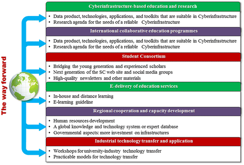
5.1. Cyberinfrastructure-based education and research
Cyberinfrastructure-based research has increasing effects on the understanding and supporting of the global Earth system, which is short of well-trained professionals equipped with a knowledge of Sensor Web, data management, big data analytics, visualization, etc. (Yue et al. Citation2015b). This demands strategies to achieve a synergistic relationship between advances in Cyberinfrastructure research and Geoinformatics education. To benefit from the synergistic relationship between Cyberinfrastructure and education, geo-spatial education organizations or enterprises must provide teaching materials including suitable data products, technologies, applications, and toolkits for Cyberinfrastructure. A long-term research agenda is needed to build a reliable Cyberinfrastructure, for the use of educators, students, and researchers within governments, organizations, and institutions, to disseminate, share, collaborate, and review data, information, and knowledge (Yang et al. Citation2010). This can reinforce capacity building to promote sharing of various resources within the ISPRS and beyond. Resources for sharing include but are not limited to online or offline test data (RS images, vector, statistic data, and documents), sensor resources, algorithms, geoprocessing knowledge, teaching materials including courseware, and open source software (He et al. Citation2015; Yue, Zhang, and Tan Citation2015c). Currently, the appropriate way is to adopt Web Service technologies, where students and researchers can investigate various scientific problems in a Web-based environment with online tools and services.
5.2. E-delivery of education services
Traditional classroom-centered teaching methods will find it difficult to meet the large group of Geoinformatics practitioners who are trained on the job. New approaches or programmes in Geoinformatics education that emphasize in-house and distance learning are needed. The ISPRS should devote efforts to collecting, sharing, and maintaining E-learning resources, and then recommending, developing, and evaluating best E-learning practice examples. Emerging E-learning methods prevailing globally should be investigated. An extensive document will serve as a guideline for E-learning, education, and training, to be offered in the field of P&RS&SIS (Vyas Citation2014). The ISPRS will continue the successful software Computer Assisted Teaching CONtest (CATCON) series at ISPRS Congresses as well.
5.3. International collaborative education programmes
International collaborative education programmes aim at cultivating global views in Geoinformatics. On the one hand, joint education programmes between universities from developing countries and first-world universities, such as dual bachelor and master’s degrees will be promoted. A comprehensive list of existing best practices for joint education programmes will be summarized and distributed. On the other hand, the ISPRS should encourage institutions from fast developing countries to establish international research centers, and support them in building international Geoinformatics schools, through curriculum development.
5.4. Regional cooperation and capacity development
Enhancing regional cooperation and capacity development will maintain ISPRS’s leadership role in P&RS&SIS and relevant disciplines. There are still large gaps across regions in the field of Geoinformatics education and industry. For example, developing countries lack important skills and abilities to develop national Geoinformatics industry. Such gaps can be filled by outsiders with quick injections of know-how. Revolutions in information and communication technologies (ICT) offer ample opportunities for developing novel models of technical cooperation and new strategies for capacity-building and development assistance (Fukuda-Parr and Lopes Citation2013). For human training, massive learning and distance learning solutions would be welcome. Concerning institutional aspects, developing a global knowledge and technology system, or expert database, within Geoinformatics education and industry, with the help of ICT, is highly recommended. Regional activities such as 3S – Summer Students Seminars will still continue. Concerning governmental aspects, developing countries are encouraged to invest in infrastructure, or participate in existing information infrastructure, such as GEOSS (Global Earth Observation System of Systems), INSPIRE (Infrastructure for Spatial Information in Europe), and DataONE (Data Observation Network for Earth).
5.5. Further development of student consortium
Today’s students and young researchers and professionals are the next generation of our society and future world. On the one hand, recognizing the importance of mentoring young people, the ISPRS SC will continue to connect the younger generation to more experienced scholars and professionals, and to voice the needs of students and young professionals during their study and early career in P&RS&SIS. On the other hand, the ISPRS SC will also continue to act as a platform for experienced scholars and professionals to transfer their knowledge and experience to young people, not only for technical aspects but also as role models for students and young professionals to develop their skills and build capacities. SC will continue to actively carry out its missions and participate in ISPRS activities. The series of ISPRS Summer Schools has come into prominence and attracted attention from international meetings, offering to bid for hosting the summer school each year. For example, a week-long summer school with lectures, practical laboratories, and social events was held on the eve of the XXIII ISPRS Congress in Prague, Czech, in 2016. Future summer schools will preferably be held in developing countries and more evenly distributed in different continents to have a more complete geographic coverage worldwide. In addition to summer schools, SC will also cooperate with other commissions and working groups to help organize student and youth activities in ISPRS-related events.
Several initiatives and task-force groups are formed within the ISPRS SC to further strengthen the efficacy of the SC. For example, in addition to existing SC board members, SC has appointed national and regional coordinators to recruit more members and establish closer relationships with local and regional organizations and sister societies. A web-reform group is tasked with developing the next generation of the SC website and social media groups. The SC Newsletter editorial and publication team also seeks to enhance the capacity in publishing high quality newsletters and other materials. In a short summary, the ISPRS SC is expecting not only to increase the number of members but also to carry out the missions of communicating among students, young professionals and experienced practitioners more efficiently, connecting them with the ISPRS and related activities, and promoting P&RS&SIS to young people.
5.6. Industrial technology transfer and application
Significant importance is attached to knowledge and technology transfer, especially industrial applications of cutting-edge technology. The ISPRS will initiate and organize workshops on university–industry technology transfer and research collaboration. The benefits are three-fold: the universities or transferors will benefit from transfer fees without concern about the industrial application of the technologies; the enterprises or transferees will benefit from productivity improvements without long-range investments on research and development; and the ISPRS will benefit from a new channel for solicitation of support from potential sponsors for the projects and activities. Acting as an intermediary agent, the ISPRS needs to investigate and assess existing models of industrial technology transfer, and devise practicable models for technology transfer in Geoinformatics.
6. Conclusions
Geoinformatics education has been an essential activity in the ISPRS and provides momentum to sustainable development within the society. It also holds the key to future development of the geoscience and related industries. This paper describes the motivation of education, technology transfer, and capacity in Geoinformatics, and explains and illustrates the roles of the ISPRS in it. Educational activities, since 2012 are evaluated and some useful lessons are drawn from them. Finally, we provide a vision to direct future activities and topics within the ISPRS on education and outreach.
To supply continued fuel for the ISPRS, there are still endeavors to make for education and outreach. Strengthening Cyberinfrastructure-based research and education will support Geoinformatics education and industries. E-delivery of education services will provide feasible ways to address labor shortages in the Geoinformatics fields. Promotion of international collaborative programs will develop a new generation with cross-border educational backgrounds. Imbalanced regional development among ISPRS members will be addressed by enhancing regional cooperation and capacity development. Efforts spent on nurturing younger members will result in a rewarding future for the Society, and industrial technology transfer will benefit academia and industry, and the ISPRS. These activities will not only provide a sustainable development for the ISPRS but also raise its influence worldwide.
Funding
The work was supported by the Program for New Century Excellent Talents in University in China [grant number NCET-13-0435]; the Hubei Science and Technology Support Program in China [grant number 2014BAA087]; the National Natural Science Foundation of China [grant number 91438203]; and the Major State Research Development Program of China [grant number 2016YFB0502301].
Notes on contributors
Jianya Gong is an academician of Chinese Academy of Science, and dean of the School of Remote Sensing and Information Engineering, Wuhan University, China. His research interests include geo-spatial data structure and data model, geographical information system software, geo-spatial data sharing and interoperability, photogrammetry, GIScience, and remote sensing applications.
Peng Yue is a professor with Wuhan University. His research interests include earth science data and information system, and geographical information services.
Tsehaie Woldai is a professor with the School of Geosciences, University of Witwatersrand, Johannesburg, South Africa. His research interest is on remote sensing data processing and applications.
Fuan Tsai is a professor with Center for Space and Remote Sensing Research, National Central University. His research interests include 3D spatial analysis, high performance image analysis, and digital smart city modeling.
Anjana Vyas is an adjunct professor and executive director, Centre for Advanced Geomatics with CEPT University, India. Her research interests include remote sensing and GIScience applications, ICT, urban planning, socio-economic and demography studies, and smart cities and governance.
Huayi Wu is a professor with Wuhan University, and vice director of the State Key Laboratory of Information Engineering in Surveying, Mapping and Remote Sensing (LIESMARS). His research interest is on remote sensing and Web GIS.
Armin Gruen is professor emeritus in Photogrammetry and Remote Sensing of ETH Zurich and is currently associated with the Chair of Information Architecture. His major research interest is 3D/4D modeling from images and point clouds. This is realized in the current R&D projects Virtual Singapore and Moorea IDEA (Moorea Digital Ecosystem Avatar).
Le Wang is a professor and director of undergraduate studies, with the department of geography, the State University of New York at Buffalo. His research interests include remote sensing, GIScience, forest characterization, environment modeling, land cover and land use change, urban population estimation, invasive species modeling, and spatio-temporal analysis and modeling.
Igor Musikhin is a professor and the vice-rector for International and Innovation Activities with Siberian State University of Geosystems and Technology. His research interests include photogrammetric software, remote sensing, object recognition algorithms, ESP.
Acknowledgments
We are grateful to all members of ISPRS TC VI on Education, Capacity Building and Knowledge Transfer for their work. The authors would like to thank the anonymous reviewers for their suggestions for improving this paper.
References
- Dowman, I., and K. Labbassi. 2014. “The Development of Geospatial Education and Training in North Africa.” ISPRS-International Archives of the Photogrammetry, Remote Sensing and Spatial Information Sciences 1: 1–5.10.5194/isprsarchives-XL-6-1-2014
- Elsner, P. 2005. “GIS Teaching via Distance Learning Experiences and Lessons Learned.” Planet 14: 28–29.10.11120/plan.2005.00140028
- Fukuda-Parr, S., and C. Lopes, eds. 2013. Capacity for Development: New Solutions to Old Problems. London: Routledge.
- Gong, J., H. Wu, W. Jiang, W. Guo, X. Zhai, and P. Yue. 2014. “Geospatial Service Platform for Education and Research.” ISPRS − International Archives of the Photogrammetry, Remote Sensing and Spatial Information Sciences 1: 31–36.
- Gong, J., H. Wu, W. Gao, and W. P. Yue, and X. Zhu. 2009. “Geospatial Service Web.” In Geospatial Technology for Earth Observation Data, edited by D. Li, J. Shan, and J. Gong, 355–379. New York: Springer.
- Gong, J., H. Wu, T. Zhang, Z. Gui, Z. Li, L. You, S. Shen, J. Zheng, J. Geng, K. Qi, W. Yang, Z. Li, and J. Yu. 2012. “Geospatial Service Web: Towards Integrated Cyberinfrastructure for GIScience.” Geo-spatial Information Science 15 (2): 73–84.10.1080/10095020.2012.714098
- He, L., P. Yue, L. Di, M. Zhang, and L. Hu. 2015. “Adding Geospatial Data Provenance into SDI − A Service-Oriented Approach.” IEEE Journal of Selected Topics in Applied Earth Observations and Remote Sensing 8 (2): 926–936.10.1109/JSTARS.2014.2340737
- Molenaar, M. 2004. “Capacity Building for Geoinformatics: An ITC Perspective.” In Invited paper ISPRS Congress XX, Istanbul, Turkey, July.
- Kumar, P., A. Siddiqui, K. Gupta, S. Jain, and Y. K. Krishna Murthy. 2014. “Capacity Building through Geospatial Education in Planning and School Curricula.” ISPRS-International Archives of the Photogrammetry, Remote Sensing and Spatial Information Sciences 1: 1253–1259.10.5194/isprsarchives-XL-8-1253-2014
- Li, D., J. Gong, and P. Yue. 2014. “Geoinformatics Education in China.” Geo-spatial Information Science 17 (4): 208–218.10.1080/10095020.2014.985282
- OGC. 2015. “W3C and OGC to Collaborate to Integrate Spatial Data on the Web”. Accessed March 30. http://www.opengeospatial.org/pressroom/pressreleases/2149
- Teo, T. A., H. M. Wu, T. Y. Shih, and F. Tsai. 2014. “The analysis of smartphone apps in Geomatics education.” ISPRS − International Archives of the Photogrammetry, Remote Sensing and Spatial Information Sciences 1: 93–97.
- Tsai, F., and L. C. Chen. 2014. “Challenges of Remote Sensing and Spatial Information Education and Technology Transfer in a Fast Developing Industry.” ISPRS − International Archives of the Photogrammetry, Remote Sensing and Spatial Information Sciences 1: 103–106.
- UNCED. 1992. Agenda 21: A Programme for Action for Sustainable Development. New York: United Nations.
- Vyas, A., and G. Koenig. 2014. “Computer Aided Teaching in Photogrammetry Remote Sensing and Geomatics − A Status Review.” ISPRS-International Archives of the Photogrammetry, Remote Sensing and Spatial Information Sciences 1: 113–118.10.5194/isprsarchives-XL-6-113-2014
- Vyas, A. 2014. Assessment of Learning Pedagogy in GeoInformatics, 8. Ahmedabad: ISPRS Scientific Initiatives.
- Wan, Z., Y. Hong, S. Khan, J. Gourley, Z. Flamig, D. Kirschbaum, and G. Tang. 2014. “A Cloud-based Global Flood Disaster Community Cyber-infrastructure: Development and Demonstration.” Environmental Modelling & Software 58: 86–94.10.1016/j.envsoft.2014.04.007
- Yang, C., R. Raskin, M. Goodchild, and M. Gahegan. 2010. “Geospatial Cyberinfrastructure: Past, Present and Future.” Computers, Environment and Urban Systems 34 (4): 264–277.10.1016/j.compenvurbsys.2010.04.001
- Yue, P., R. Ramachandran, P. Baumann, S. Khalsa, M. Deng, and L. Jiang. 2016a. “Recent Activities in Earth Data Science.” IEEE Geoscience and Remote Sensing Magazine 4 (4): 84–89.10.1109/MGRS.2016.2600528
- Yue, P., X. Guo, M. Zhang, L. Jiang, and X. Zhai. 2016b. “Linked Data and SDI: The Case on Web Geoprocessing Workflows.” ISPRS Journal of Photogrammetry and Remote Sensing 114: 245–257.10.1016/j.isprsjprs.2015.11.009
- Yue, P., P. Baumann, K. Bugbee, and L. Jiang. 2015a. “Towards Intelligent GIServices.” Earth Science Informatics 8 (3): 463–481.10.1007/s12145-015-0229-z
- Yue, P., C. Zhang, M. Zhang, X. Zhai, and L. Jiang. 2015b. “An SDI Approach for Big Data Analytics: The Case on Sensor Web Event Detection and Geoprocessing Workflow.” IEEE Journal of Selected Topics in Applied Earth Observations and Remote Sensing 8 (10): 4720–4728.10.1109/JSTARS.2015.2494610
- Yue, P., M. Zhang, and Z. Tan. 2015c. “A Geoprocessing Workflow System for Environmental Monitoring and Integrated Modelling.” Environmental Modelling & Software 69: 128–140.10.1016/j.envsoft.2015.03.017
- Yue, P., J. Gong, L. Di, J. Yuan, L. Sun, Z. Sun, and Q. Wang. 2010. “GeoPW: Laying Blocks for the Geospatial Processing Web.” Transactions in GIS 14 (6): 755–772.10.1111/tgis.2010.14.issue-6