
Abstract
The paper discusses the need of a high-level query language to allow analysts, geographers and, in general, non-programmers to easily cross-analyze multi-source VGI created by means of apps, crowd-sourced data from social networks and authoritative geo-referenced data, usually represented as JSON data sets (nowadays, the de facto standard for data exported by social networks). Since an easy to use high-level language for querying and manipulating collections of possibly geo-tagged JSON objects is still unavailable, we propose a truly declarative language, named J-CO-QL, that is based on a well-defined execution model. A plug-in for a GIS permits to visualize geo-tagged data sets stored in a NoSQL database such as MongoDB; furthermore, the same plug-in can be used to write and execute J-CO-QL queries on those databases. The paper introduces the language by exemplifying its operators within a real study case, the aim of which is to understand the mobility of people in the neighborhood of Bergamo city. Cross-analysis of data about transportation networks and VGI from travelers is performed, by means of J-CO-QL language, capable to manipulate and transform, combine and join possibly geo-tagged JSON objects, in order to produce new possibly geo-tagged JSON objects satisfying users’ needs.
1. Introduction
Volunteered Geographic Information (VGI), created by means of smart applications installed on mobile devices connected to the Internet, and geo-tagged crowd-sourced information, created within social networks, also named user-generated geo-tagged contents, are attracting more and more the interest of both scientific and business companies. Let’s think about the many citizen science projects in which VGI is created by amateurs eager to contribute to science, by describing observations of entities of interests in situ. For example, in the projects named iNaturalist Footnote 1 and eBird Footnote 2 (see Fitzpatrick et al. Citation2002), flora and fauna observations are collected to study climate changes in relation to the geographic distribution of species’ habitats. Such projects could not be carried out without cross-analyzing the distribution of VGI all over the world and information about geographic areas recognized to be the habitats of species.
There exist many other application fields for cross-analysis of VGI, crowd-sourced and authoritative data. An example could be understanding how to improve public transportations, based on actual users needs, as well as understanding where to open new restaurants, discovering the areas of a city mostly visited by tourists, etc.
To ease such a kind of cross-analysis, a novel framework that permits to overlay, compare and correlate geo-tagged information from volunteers, crowd- sourced and authoritative information within the same digital environment is needed by analysts. Furthermore, the everyday increasing adoption of non-relational models for representing data coming from social networks and VGI apps, as well as for authoritative information published in open data portals, significantly stresses the need for flexible tools to cross-analyze heterogeneous collections. In particular, JSON is now the de facto standard for information representation and exchange.
Current GISs, are inadequate for this purpose. They are suitable for spatially visualizing and manipulating classical geographic data layers in standard vectorial and raster formats; now, they are also able to load and export geographic information in GeoJSON format, which relies on JSON syntax. Nevertheless, they provide limited facilities to manipulate GeoJSON objects, and, more important, they do not provide a declarative query language to manipulate GeoJSON entities. For example, QGIS, the open source GIS software, cannot visualize GeoJSON objects with geometries of distinct types at once: different geometry types must bein different layers (this way, the same entity may appear in different layers). Furthermore, if GeoJSON is attractive for its capability of representing entities with very complex geometry (possibly mixing points, polylines and polygons), it is still focused on geometric entities, instead of representing geo-tagged JSON objects, i.e. objects enriched with a geographic tag.
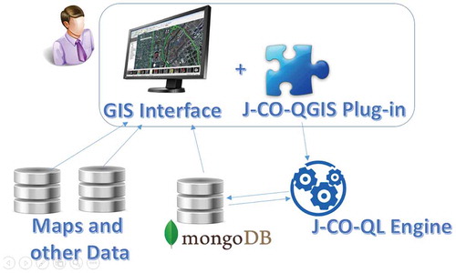
Based on such premises, the goal of our research work is to devise J-CO, a framework for performing complex transformations and aggregations of collections of pure JSON objects possibly geo-tagged with complex geometry, originated by multiple sources. The core of the framework is a declarative query language named J-CO-QL, in the style of SQL spatial, for creating, modifying, selecting, merging, and cross-analyzing collections of possibly geo-tagged JSON objects. We implemented a plug-in for QGIS to visualize geo-tagged JSON objects together with other geographical layers, as well as to issue J-CO-QL queries to the query engine. Collections of JSON objects are stored in databases managed by MongoDB, one of the most famous NoSQL DBMSs.
The paper will rely on a case study (described in Section 1.1) based on our experience in a real project. Then, after the related work is discussed in Section 2 and a preliminary description of the J-CO framework is reported in Section 3, the J-CO-QL query language will be introduced while describing the cross-analysis tasks conducted on the data-sets of our case study in Sections 4, 5 and 6. Finally, Section 7 draws the conclusions.
1.1. Case study: people mobility in Bergamo Neighborhood
The goal of this paper is to show that, by designing a consistent framework for the definition of declarative operators and their chained evaluation, it is possible to compose queries specifying complex manipulations. To this aim, we make use of a case study originated from a research project whose final goal is to understand how workers, students and tourists move in the city of Bergamo. We are exploiting a collaborative and social approach: volunteers (in our context students and workers) participate to the research supported by an app for mobile devices named Moves.Footnote 3 This app continuously traces registered people, characterizing the type of movements performed by them (on foot, by car or other transport means). We ask volunteers to register to our web site, so that we can automatically get their traces from Moves APIs.
In order to understand how many people use trains to get to the city, besides VGI of travelers we collected information about rails, provided by official authoritative sources. All these data-sets are represented as collections of JSON objects and stored within a NoSQL MongoDB database. This choice is motivated by the fact that these data-sets are heterogeneous in terms of structure, with distinct levels of nesting, so traditional relational technology is not suitable for them.
The challenges that we have to face in our case study are manifold.
We have to cross-analyze traces of people with railway lines, in order to detect the number of volunteers that travel through public transport lines.
We have to provide tools for performing such an analysis that do not require to write computer programs, but specifying high-level queries to manipulate, select and filter the data-sets.
2. Related work
J-CO-QL moves from our previous work on the problem of querying heterogeneous collections of complex spatial data (see Bordogna, Pagani, and Psaila Citation2006; Psaila Citation2011). In that works, we proposed a database model capable to deal with heterogeneous collections of possibly nested spatial objects, based on the composition of more primitive spatial objects; at the same time, a relational algebra to query complex spatial data is provided. With regard to those works, J-CO-QL relies on the JSON standard and does not require an ad-hoc data model; furthermore, J-CO-QL abandons the relational algebra syntax, in favor on a more flexible and intuitive execution model.
The adoption of NoSQL databases is motivated by the need of flexibility, as far as data structures are concerned. An interesting survey about NoSQL databases can be found in Han et al. (Citation2011), where several systems are cataloged and classified. In particular, a DBMS like MongoDB falls into the category of document databases, because collections of JSON objects are generically considered as documents. Consequently, the query language provided by such a system does not allow complex and multi-collection transformations like those provided by J-CO-QL (see the web sites reported in the footnoteFootnote 4 for details). Readers interested in NoSQL DBMSs evaluation can refer to Robin and Jablonski (Citation2011) and to Cattell (Citation2011).
As far as query languages for JSON objects are concerned, several proposals were made. However, none of them is explicitly designed to provide geographical data analysis capabilities, natively integrated in a high-level query language, as for J-CO-QL. Hereafter, we shortly refer to them.
Jaql (see Nayak, Poriya, and Poojary Citation2013) was designed to help Hadoop (see White Citation2012) programmers writing complex transformations, avoiding low-level programming, to perform in a cloud and parallel environment. Flexibility and physical independence are the main goals of Jaql: in particular, its execution model is similar to our execution model, since it explicitly relies on the concept of pipe; in fact, the pipe operator is explicitly used in Jaql queries. However, it is still oriented to programmers, while J-CO-QL constructs are at a higher level and truly declarative.
An interesting proposal is SQL++ that has been defined to query both JSON native stores and SQL databases. The SQL++ semi-structured data model is a superset of both JSON and the relational data model. Yet, SQL++ is SQL backwards compatible and is generalized towards JSON by introducing only a small number of query language extensions (Ong, Papakonstantinou, and Vernoux Citation2014). In SQL++, the classical SELECT statement of SQL is adapted and extended to perform queries on collections of JSON objects. In our opinion, this is a clean proposal, if compared with others, that tries to work at a higher abstraction level. However, it does not deal explicitly with heterogeneity of objects. Furthermore, complex transformations that require several queries sequentially executed would need to explicitly save intermediate results into the persistent database. In contrast, the execution model on which J-CO-QL relies clearly separate persistent databases and temporary databases.
Also the industry is looking at the extension of SQL to query JSON objects. An example is N1QL Footnote 5 that is a declarative language extending SQL for JSON objects stored in NoSQL databases, specifically implemented for Couchbase 4.0, in order to handle semi-structured, nested data. It enables querying JSON documents without any limitations, sort, filter, transform, group, and combine data with a single query from multiple documents with a JOIN. Nevertheless it does not provide operators to manipulate GeoJSON objects. Finally, other declarative languages for JSON objects have been defined as extensions of structured languages for semi-structured documents, such as JSONiq Footnote 6 that borrowed a large numbers of ideas from XQuery, like the functional aspect of the language, the semantics of comparisons in the face of data heterogeneity, the declarative, snapshot-based updates. Nevertheless, like XQuery it can be hardly used by unexperienced users.
3. J-CO framework
As previously introduced, the J-CO framework (which stands for JSON COllections) has been devised to enable non programmers to perform complex geo-spatial queries on geo-tagged JSON data-sets stored within a MongoDB database; furthermore, we wanted users to be able to visualize such data-sets within classical GIS environments. Figure depicts the high-level components in the J-CO framework, and hereafter, we describe them.
The framework is founded on a Data Model and an Execution Model, that make possible to define a query language, that we called J-CO-QL. This novel query language is specifically designed to specify complex geo-spatial analysis tasks on heterogeneous collections of JSON objects.
The J-CO-QL Engine executes queries on the collections stored within MongoDB databases and stores results into (possibly different) MongoDB databases.
The J-CO-QGIS Plug-in provides QGIS (the free and widely used GIS tool) users with the possibility to explore collections in MongoDB databases and show geo-tagged JSON objects and their geometries as spatial layers, so that they can be overlaid with other information layers.
Figure 1. Components of the J-CO Framework.
3.1. Data and execution models
3.1.1. Data model
The data model is founded on the basic concept of JSON object. JSON (JavaScript Object Notation) is a de facto standard serialized representation for objects. Fields (object properties) can be simple (numbers or strings), complex (i.e. nested objects), arrays (of numbers, strings, objects).
As far as spatial representation is concerned (i.e. geo-tagging of JSON objects), we rely on the GeoJSON standard (see Butler et al. Citation2016). In particular, we assume that the geometry is described by a field named geometry, defined as a GeometryCollection object type in GeoJSON standard. The absence of this top-level field means that the object does not have an explicit geo-tag. J-CO-QL provides constructs to add geo-tags to JSON objects.
The following definition formalizes the concepts of Collection and Database.
Definition 1 (Collections and Databases):
A Database db is a set of collections: {
}. Each collection c has a name c.name (unique in the database) and an instance Instance(c)
that is a vector of JSON objects
.
3.1.2. Execution model
Queries will transform collections stored in databases managed by MongoDB and will generate new collections that will be stored again into MongoDB databases, for persistence. For simplicity, we call such databases as Persistent Databases
Definition 2 (Query Process State):
A state s of a query process is a pair , where tc is a collection named Temporary Collection. while IR is a database named Intermediate Result database.
Definition 3 (Operator Application):
Consider an operator op. Depending on the operator, it is parametric w.r.t. input collections (present in the persistent databases or in IR) and, possibly, w.r.t. an output collection, that can be saved either in the persistent databases or in IR.
The application of an operator op, denoted as , is defined as:
where both domain and co-domain are the universe of query process states. The operator application takes a state s as input, possibly works on the temporary collection s.tc, possibly takes some intermediate collections stored in s.IR; then, it generates a new query process state , with a possibly new temporary collection
and a possibly new version of the intermediate result database
.
The idea is that the application of an operator starts from a given query process state and generates a new query process state. The temporary collection tc is the result of the operator; alternatively, the operator could save a collection as intermediate result into the IR-pagination database, that could be taken as input by a subsequent operator application.
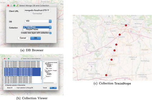
Figure 2. J-CO-QGIS plugin’s DB Browser and Collection Viewer windows and train stops imported from a MongoDB collection.
Definition 4 (Query):
A query q is a non-empty sequence of operator applications, i.e. , with
.
Each operator application starts from a given query process state and generates a new query process state, as defined by the following definition.
Definition 5 (Query Process):
Given a query , a query process QP is a sequence of query process states
, such that
and, for each
, it is
.
The query process starts from the empty temporary collection and the empty intermediate result database
. Thus, J-CO-QL provides operators (named start operators) able to start the computation, taking collections from the persistent databases, while other operators (named carry on operators) carry on the process, continuously transforming the temporary collection and possibly saving it into the persistent databases or, for temporary results, into the intermediate result database IR. This way, new sub-tasks can be started, by taking collections both from persistent databases and from IR.
3.1.3. Innovative features
The intermediate result database IR is motivated by the need to support complex transformation processes that typically proceed through the computation of several intermediate results. In fact, it would be inappropriate to store them into the persistent databases that should store source and target collections. Furthermore, by means of IR, intermediate collections are clearly stated to be intermediate, and disappear from the system at the end of the process. Nevertheless, IR is implicitly related to each single execution process, that is automatically managed in isolation, w.r.t. other execution processes.
The procedural flavor is the result of the applications of operators: they are declarative (see next sections) but their application defines a process. Anyway, queries are not programs, in the sense of procedural programming languages: they are processes.
3.2. J-CO-QL query language and its execution engine
The key components of the J-CO framework are the query language, named J-CO-QL, and its execution engine.
Typical limitations of other query languages for JSON collections are the inability of dealing with heterogeneous objects in the same collection at the same time (typically, several queries must be written and then their results united together). J-CO-QL provides operators specifically designed to deal with objects with different structure within the same operator application.
A second typical limitation of other languages for querying JSON data is that they are thought for programmers, or at least for people having programming skills. In contrast, operators provided by J-CO-QL are high-level operators, based on a declarative approach.
Finally, J-CO-QL directly deals with spatial representations possibly contained in JSON objects, because its data model explicitly consider them. Other languages completely miss support for managing spatial representation. In the rest of the paper, we will present relevant operators of J-CO-QL by explaining their use in transformation tasks. The reader can refer to our internal report (see Capelli et al. Citation2017) for a detailed description of the language.
The J-CO-QL Engine actually executes J-CO-QL queries. It is a Java tool that receives queries from the J-CO-QGIS Plug-in , extracts collections from within MongoDB persistent databases, executes queries and saves final results into MongoDB persistent databases.
3.3. The J-CO-QGIS plug-in for QGIS
In order to provide analysts with a powerful tool for querying and visualizing data within classical GIS software, we developed a plug-in for QGIS, the free GIS software.
The plug-in, named J-CO-QGIS, provides basic, yet useful, functionalities. In particular:
The DB Browser allows users to connect to MongoDB persistent databases to select the collections to show.
The Collection Viewer takes collections from MongoDB persistent databases and loads those objects with geometrical representation (having the
geometry field) into QGIS as new information layers.
The Query Issuer is a text editor that allows users to write J-CO-QL queries and send them to the J-CO-QL engine.
Figure (a) shows the DB Browser: first of all, the user must specify the connection string to the MongoDB server.Footnote 7 By clicking on the Connect button, the plug-in actually connects to the specified MongoDB server and shows the list of available databases. By browsing this list, shown in the DB list-box, the user chooses the database from which to get the desired collection. The content of the Collection list-box is updated, with the list of collections available in the chosen database.
In Figure (a) we connected to our Mongo server, and selected the VGI database, that contains two collections: TrainStops and PeopleTraces. We selected the first collection.
The selected Create new layer with collection flag, causes the immediate generation of a QGIS layer with all geo-tagged objects contained in the chosen collection. After pressing the OK button, the Collection Viewer’s window is open.
Figure (b) shows the Collection Viewer. In this window, it is possible to select objects of interest to add to the layer; the right-hand side area shows the full structure of selected JSON objects. In the example, we selected objects having “Bergamo-Treviglio” as value for the line field. The Insert selection to MongoDB button re-exports the selected objects into a new collection within the persistent database, whose name will be asked in a prompt. The OK button shows the selected objects. Figure (c) depicts the layer created with the objects selected from collection TrainStops.
Figure 3. Query Issuer, selection of traces for a single person and the trace added as new layer in QGIS.
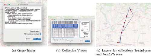
Figure 4. Intermediate collection TrainStops (stops of train lines).
The user can write and execute J-CO-QL queries through the Query Issuer window, shown in Figure (a). Currently, this is a simple text editing window with a button that actually sends the query to the Query Engine.
Suppose that a complex process has been performed, obtaining a new collection named PeopleTraces, that describes traces of people. If we select objects related to traces of some people of interest (Figure (b)), in QGIS we can easily overlay this new layer with the one created for collection TrainStops, as shown in Figure (c). This possibility allows users to perform visual analysis of the query results.
4. Transforming data concerning train lines
We are now ready to illustrate how J-CO-QL can be exploited to specify complex transformation processes on our data sets. We will introduce the main J-CO-QL operators by exemplifying their behavior when they appear in the queries.
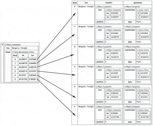
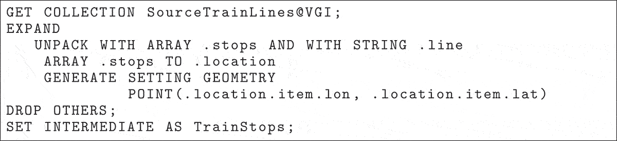
The first process we show transforms data concerning train lines. This process is necessary to build a representation of train lines suitable for next processes. Suppose we have a collection named SourceTrainLines stored in the persistent database named VGI. Each object in the collection describes a line, by means of two fields, named line and stops. The former field is the name of the line; the latter is an array of objects, each one describing a stop in terms of longitude (field lon) and latitude (field lat). A sample is reported hereafter, concerning the line that connects Bergamo to Treviglio (a small city 20 km far away from Bergamo).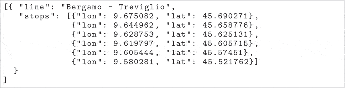
This format is not suitable for processing people traces since there is no evidence about station names. Furthermore, there is not explicit geo-tagging (there is not a geometry field) compliant with our data model. Consequently, we need to transform it in order to perform other activities such as geo-coding.
The J-CO-QL query that performs the transformation is reported hereafter. In the following, we explain the query, by meantime introducing the operators.
The GET COLLECTION operator starts the process, retrieving the collection named SourceTrainLines from the persistent database named VGI; this collection becomes the new temporary collection.
At this point, we want to unnest objects contained within array fields named stops, in order to get one object for each stop. The EXPAND operator performs this task.
In details, the UNPACK clause is a condition that checks for the objects contained in the temporary collection that have all the desired fields; in particular, we want to process objects having an array field named stops and a string field named line.
For such objects, the array field named stops is unpacked and a new temporary object is generated for each item contained within the array.
contains all fields in the input objects (except for the unpacked array field), plus an extra field named location, as specified after the TO keyword. Field location is a nested object that contains two fields: item is the item extracted from within the array (in this case, the object with fields lon and lat); position is the position of the item in the array (starting from 1). The GENERATE action actually generates the output object
to insert into the output temporary collection, by deriving it from
and by generating the
geometry field ( SETTING GEOMETRY specification), that is derived as a POINT (notice that coordinates are taken from the coordinates in the item object within the new field location).Footnote
8
The final option DROP OTHERS says that objects in the input temporary collection that donot match the UNPACK condition are discarded from the output (none, in this case).
The new collection is then saved by the SET INTERMEDIATE operator into the intermediate result database IR with name TrainStops.
The left-hand side of Figure shows again collection SourceTrainLines pretty formatted; the right-hand side of figure shows the collection TrainStops; arrows show the correspondence between elements in the unpacked array and new objects.
4.1. Geo-coding of stops as stations
In order to associate every stop in the train lines with the corresponding station name, it is necessary to perform a geo-coding activity, based on a collection, named TrainStations, that reports information about stations, including their coordinates. Here, we will show how a usually non trivial task like geo-coding can be easily done by means of J-CO-QL operators.
Figure 5. (a) Collection TrainStations, describing coordinates of stations; (b) The intermediate collection LineStopsCoded.
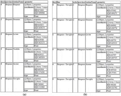
Figure (a) reports collection TrainStations for our case study, describing stations on line Bergamo-Treviglio. Notice the presence of the geometry field in each object.
The geo-coding task on train lines is defined by the J-CO-QL query reported in Figure .
Figure 6. Process “Geo-coding of Stops as Station”.
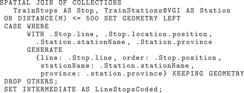
The key operator for performing geocoding is the SPATIAL JOIN operator (introduced in our language in Bordogna, Capelli, and Psaila (Citation2017)). It takes two collections (either stored in a MongoDB persistent database or in the intermediate result database IR) and builds pairs of objects coming from the two input collections, on the basis of the relationship existing between their geometries.
In our case, we join objects in the collection TrainStops (in the intermediate result database IR), that describe stops of train lines, with collection TrainStations, stored in the persistent database VGI, that describe stations. The two collections are aliased, within the operator, as Stop and Station, respectively.
The spatial join is performed on the basis of the spatial join condition that follows the ON keyword: two objects are joined if their distance is less than 500 m (a reasonable distance, considering the area occupied by train stations). Let’s consider two source objects (from the left collection) and
(from the right collection). A temporary object
is generated if
.
geometry and
.
geometry satisfy the spatial join condition.
has three fields: one has the name (or alias) of the left collection and its value is the entire object
; the second field has the name (or alias) of the right collection and its value is the entire object
; the third one is
geometry, containing the overall geometry. As far as the geometry of
is concerned, in our case we specified SET GEOMETRY LEFT, meaning that we keep the geometry of the left object
; alternatively, we can specify RIGHT, INTERSECTION, ALL (the last option merges the two collections).
Figure illustrates the semantics of spatial join. In Figure (a) and (b) we report, respectively, an object from collection TrainStops (aliased as Stop), that is the source object , and an object from collection TrainStations (aliased as Station), that is the source object
. When the spatial join between those two objects is performed, the temporary object in Figure (c) is generated: notice the Stop and Station fields, which correspond to the objects shown in (a) and (b). In addition, the
geometry field equals the
geometry property in
object, as specified by the SET GEOMETRY LEFT construct.
Figure 7. Spatial Join semantics: source objects, temporary object, output object for procedure in Figure .
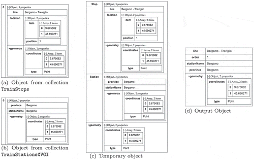
Finally, the CASE block transforms all temporary objects , in order to flatten them, removing nesting, as shown in Figure (d). Note the DROP OTHERS option, that drops all objects resulting from the spatial join that are not selected by the WHERE condition (in the example, all resulting objects satisfy the WHERE condition). As an example, Figure (d) reports the output object derived from the temporary object in Figure (c).
The resulting collection, shown in Figure (b), is stored into the intermediate result database IR with name LineStopsCoded.
The reader can notice that geo-coding has been performed in a straightforward way, directly working on JSON data and within the database, without the need to import collections into a GIS software; results are saved as JSON objects, ready for further transformations. Furthermore, notice that no attention must be paid to the actual format of geometries: the language is designed to be independent of the geometry representation.
4.2. Adding directions to lines
In order to get ready to discover volunteers that traveled by train, we need to further process the intermediate collection LineStopsCoded we obtained after geo-coding. In fact, in this collection, the direction of trains is not represented. However, in order to actually find travel directions, we have to consider this issue.
The J-CO-QL query in Figure further transforms collection LineStopsCoded, cloning geocoded stops and adding a new field, named direction, whose values can be either “F” (forward) or “B” (backward).
Figure 8. Process “Adding Directions to Line”.
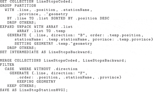
At first, geocoded stops in collection LineStopsCoded are grouped together. First of all, the GROUP operator builds a partition containing all objects satisfying the condition that follows the keyword PARTITION. These objects are grouped together by the field(s) specified after the BY keyword. For each group, an object is generated in the output temporary collection, that contains all grouping fields and the new array field specified after TO keyword. Later, this array field, that contains all the original objects that have been grouped together, is sorted by the optional SORTED BY specification. In our query, the GROUP operator groups together train stops that have the same value for field line, generating the array field named list; this array field is sorted in reverse order w.r.t. values of position field (this way, train stops of the same line are in reverse order, w.r.t. the original one).
Then, the subsequent EXPAND operator re-expands objects, having field order (derived from item position in the array) in reverse order w.r.t. the original sequence of stops in the line. Field order indicates the order of stops in the line, moving in backward direction. The resulting temporary collection is saved into the intermediate result database with name LineStopsBackward.
The MERGE operator is a binary operator that merges objects contained in two collections. In the query, collections LineStopsCoded and LineStopsBackward are merged together.
At this point, it is necessary to make objects homogeneous, because some of them have the direction field, while others have not (i.e. the ones describing the forward direction). In fact, the temporary collection contains objects with heterogeneous structures. The FILTER operator filters and restructures subsets of objects, based on the WHERE condition. In our query, the WHERE condition looks for objects without field direction (note the use of the WITHOUT predicate): these objects are regenerated by adding the missing field with value “F” and by renaming field position as order. The other objects in the input temporary collection are kept (option KEEP OTHERS), because they are complete already. The resulting collection is finally saved into the persistent database named VGI, with name LineStopsStations.
5. Transforming data concerning volunteers
In our research project, volunteered data are gathered through the app named Moves. Our web site is connected to the APIs provided by Moves servers. Data returned by Moves APIs are formatted as JSON data; however, their structure is very complex, and contains more information than that we need. Therefore, we defined a transformation process that brings the data-set into a format suitable for our analysis. Figure shows the structure (schema) of objects provided by Moves APIs.
Figure 9. Schema for Moves traces.
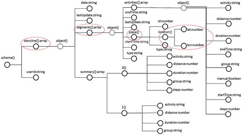
At the top level, we find only two fields; userId reports the volunteer identifier, while storyline is an array containing volunteer’s activities. Each item of this array is a complex object describing activities of one single day (see field date). In particular, we are interested in field segments, that is an array of objects.
Each object of array segments describes an activity, that can be either a stay in a place (in this case, field type is “place”), or a movement from one place to another (in this case, field type has value “move”). The objects of the latter type do not describe places, thus we have to focus only on objects of the former type. Objects of type “place” have a field named place, which contains two more fields describing, respectively, latitude and longitude of the place.
Figure 10. Process “Transforming Data concerning Volunteers”.
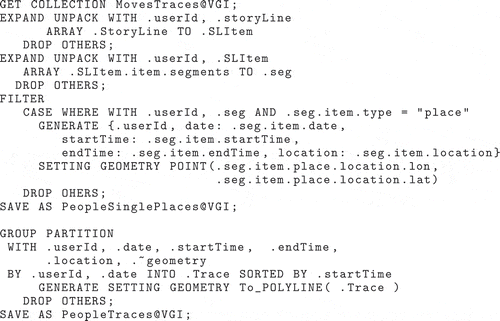
Figure 11. Intermediate collection (a) PeopleSinglePlaces (set of all places visited by people) and (b) of collection PeopleTraces (each user has, for each date, the trace within a field)
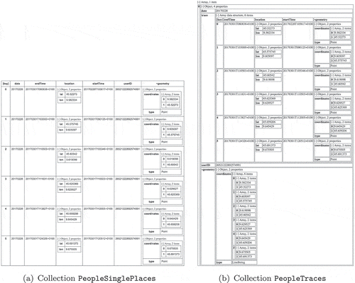
Figure 12. Process “Discovering Train Voyager”.
The J-CO-QL query reported in Figure performs this transformation and generates collection PeopleTraces reported in Figure (b). After operator GET COLLECTION, a first application of the EXPAND operator is necessary, in order to unnest objects within the array field storyLine; into the new field SLItem. Recall that this new field is an object with two fields, named item and position: the first one contains the actual item extracted from the array; the second one is the position occupied by the item within the array.
Since .SLItem.item is an object that contains an array of segments named segments, a second application of the EXPAND operator is necessary. The result is a temporary collection of objects, where each object describes, in the seg field, each segment originally contained in the segments field. Some of them have field .Seg.item.type with value “place”, other with value “move”: we want objects with type “place”.
To this purpose, the FILTER operator is used: the WHERE condition selects the desired objects and transforms them into simplest objects, deriving the geometry from lat and lon fields nested within the complex field place.
The resulting collection is saved into the persistent database VGI with name PeopleSinglePlaces, which is shown in Figure (a).
To complete the preparation of volunteers’ traces, in order to visualize them in QGIS, we further derive collection PeopleTraces shown in Figure (b). This task is performed by means of the GROUP operator. Objects are grouped together on the basis of fields userId and date; the array containing all grouped objects is named Trace and it is sorted by field startTime; finally, the overall geometry is derived by aggregating geometries of all points in array Trace into a polyline.
6. Discovering train voyagers
We are finally ready to discover train voyagers using collections LineStopsStations and PeopleSinglePlaces obtained by the previous processes. In general terms, a train voyager is a volunteer whose trace is mostly overlapped with a train line. But a question naturally arises: Is it possible to detect volunteers traces overlapped with train lines, by means of J-CO-QL current set of operators (that do not encompasses operators for sequence matching)? The answer is “yes, it is possible”. The J-CO-QL query reported in Figure shows the way in which this can be performed. The key of the process is, again, the spatial join.
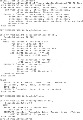
The SPATIAL JOIN operator at the beginning of the query is used to find out points in volunteers’ traces that correspond to train stations: the spatial join is performed on objects in collection PeopleSinglePlaces (depicted in Figure (a)) and collection LineStopsStations (depicted in Figure (b)); they are respectively aliased as Trace and Stop. The spatial join occurs if the trace point is less than 500 m from the station point. For each pair of spatially joined objects, a new output object is generated, which reports the user id, the date, the time, the train line, the direction, the order in the direction, the station name and the province. The collection is saved into the intermediate result database IR with name PeopleInStations.
Clearly, for the same station, two objects are generated, one with direction “F” and one with direction “B”. Consequently, it is necessary to understand if the user actually traveled by train. The idea is simple: we look for pairs of consecutive stops visited by people in the same direction and with increasing time. To do so, the JOIN operator joins the intermediate collection PeopleInStations with itself; the two occurrences of the same collection are aliased as PS1 and PS2. The JOIN operator behaves similarly to the SPATIAL JOIN operator, but the pairs of objects are built on the basis of WHERE conditions. The WHERE condition we wrote handles with two different situations at the same time: if a pair of stops of the same user in the same date is built for direction “F”, the order of point PS2 must follow the order of point PS1 and the same is for startTime; if the direction is “B”, the order of point PS2 must precedes the order of point PS1. Users with such pairs actually traveled by train.
To remove duplications, the GROUP operator groups pairs, in order to get objects that, at the external level, describes user, date, line and direction; the resulting collection is stored into the intermediate result database with name PeopleByTrain.
The last JOIN operator in the query is necessary to produce the final collection, then save it into the persistent database VGI with name PeopleByTrain, that contains traces of people discovered in the previous steps. It is the subset of traces in collection PeopleTraces that actually reveal people traveling by train. In our sample data, the only user we considered actually traveled by train, so the content of collection PeopleByTrain is the same as that of collection PeopleTraces (see Figure (b)).
Once people traveling by train are discovered, the analyst can conduct an exploratory activity through the J-CO-QGIS plug-in. For instance, Figure (c) shows the train line and the trace of our traveler overlapped on the layer describing roads.
7. Conclusions
In this paper, we presented an innovative framework for performing cross-analysis of heterogeneous data sets in the form of collections of possibly geo-tagged JSON objects. The idea is to provide powerful tools to analysts and geographers that make possible to perform complex analysis processes without writing programs, but specifying processes in a declarative way. The framework is founded on a high-level declarative query language, named J-CO-QL, specifically devised to query heterogeneous collections of (possibly) geo-tagged JSON objects. The execution model on which J-CO-QL relies is simple, intuitive, and suitable to express complex queries specifying several subtasks.
The framework is completed by J-CO-QGIS, a plug-in for QGIS that makes it possible to visualize geo-tagged JSON objects as information layers that can be overlapped with other information layers.
A real case study is illustrated that needs to cross-analyze authoritative geo-spatial data relative to transportations and volunteer’s traces collected by the use of a smart app. The case study is introduced to exemplify the possible use of the language operators. So we just presented those operators that were needed to solve the specific tasks of the case study. In fact, the language explicitly supports geographical representation and spatial aggregation operations.
The case study also shows that the J-CO framework can be effectively applied to cross-analyze transport data, coming from open data portals, authoritative sources and volunteers’ data. Obviously, the process to write depends on the actual problem to address, but the methodology is the same we show in the paper.
We are aware that J-CO-QL operators are not “easy” and need a significant effort to be used; however, the number of operators to apply is limited, even for complex processes. Readers could object that a graphical user interface could be better. However, such a user interface must rely on a robust semantic foundation. J-CO-QL plays this role: in fact, we plan to extend the J-CO-QGIS plug-in with a graphical tool to specify J-CO-QL queries without writing J-CO-QL code.
In our opinion, the J-CO framework could become a day-to-day tool for analysts. For example, if enriched with data mining operators, it could be a valuable tool to support knowledge discovery processes, in a similar way to what previously studied in Meo and Psaila (Citation2002) for XML. Furthermore, based on our previous experience in defining query languages for non-classical contexts (see Bordogna et al., Citation2002, Citation2008; Bordogna and Psaila, Citation2004, Citation2009; Psaila Citation2002), novel operators could be added, in order to provide users with powerful tools manipulating collections in a very complex way.
For example, we want to address the data independence principle, i.e. providing the capability of writing queries reducing the degree of awareness about the actual structure of JSON objects. This could be addressed in two ways: by exploring the possibility to define new higher level operators; by extending the J-CO-QGIS plug-in with a wizard that semi-automatically composes operator applications by exploring in advance the actual content of source collections and of intermediate results.
Notes on contributors
Gloria Bordogna, PhD, is a senior researcher of IREA CNR Institute for the Electromagnetic Sensing of the Environment of the Italian National Research Council. Her current research concerns flexible content-based querying of catalogue services, fuzzy ontologies for VGI creation and querying, and fuzzy quality assessment and spatio-temporal analytics of crowdsourced geotagged information. She has published 200 papers in journals and in the proceedings of international and national conferences, among which 90 papers are listed in the Web of Science.
 Steven Capellireceived his PhD in computer science from the University of Bergamo (Italy) in 2017. Currently, he is a post-doc at Dipartimento di Informatica, Sistemistica e Comunicazione of Università degli Studi di Milano-Bicocca (Italy). His research interests have been focused on information security, service component architecture, NoSQL databases, and geoSpatial data, Information retrieval.
Daniele E Ciriello, PhD, received his MSc degree from the University of Bergamo in 2016. He is now post-graduate fellow at DITESIS Lab at the University of Bergamo.
Giuseppe Psailais a researcher and professor at the University of Bergamo, Italy. He received his PhD from the Politecnico di Torino (Italy) in 1998. Current research interests cover retrieval and management of open data, big data, and geographical data.
Notes
4 MongoDB: https://www.mongodb.com/ CouchDB: http://docs.couchdb.org/en/2.0.0/.
7 The connection URL has the URI form mongodb://user:[email protected]/the_database?authMechanism=SCRAM-SHA-1.
8 In J-CO-QL, fields are referenced by a dot notation which starts with a dot. For Example, .location is a field in the root level of the object, .location.item.lat references a field lat contained in the upper object field item that, in turns, is contained in the root object field location. The “.” at the beginning means that we start from the root of the object, i.e. the most external level of the object.
References
- Bordogna, G. , A. Campi , G. Psaila , and S. Ronchi . 2002. “A Language for Manipulating Clustered Web Documents Results.” Proceedings of CIKM08, Napa Valley, CA, November 2008.
- Bordogna, G. , S. Capelli , and G. Psaila . 2017. “A Big Geo Data Query Framework to Correlate Open Data with Social Network Geotagged Posts.” In International Conference on Geographic Information Science , 185–203. Berlin: Springer.
- Bordogna, G. , M. Pagani , and G. Psaila . 2006. “Database Model and Algebra for Complex and Heterogeneous Spatial Entities.” In Progress in Spatial Data Handling , edited by A. Riedl , W. Kainz and G. A. Elmes , 79–97. Berlin: Springer.
- Bordogna, G. , and G. Psaila . 2004. “Fuzzy-spatial SQL.” In International Conference on Flexible Query Answering Systems , 307–319. Berlin: Springer.
- Bordogna, G. , and G. Psaila . 2009. “Soft Aggregation in Flexible Databases Querying based on the Vector p-norm.” International Journal of Uncertainty, Fuzziness and Knowledge-Based Systems 17 (supp01): 25–40.
- Bordogna, G. , and G. Psaila . 2008. “Customizable Flexible Querying for Classical Relational Databases.” In Handbook of Research on Fuzzy Information Processing in Databases , edited by J. Galindo , 191–217. Hersey: Information Science Reference.
- Butler, H. , M. Daly , A. Doyle , S. Gillies , S. Hagen , and T. Schaub . 2016. The GeoJSON Format . Technical Report RFC 7946. Fremont, CA: IETF.
- Capelli, S. , P. Fosci , F. Marini , and G. Psaila . 2017. J-CO-QL: A Flexible Query Language for Complex Geographical Analysis of Heterogeneous Geo-tagged JSON Data Sets . Technical Report. http://cs.unibg.it/psaila/j-co-ql/internal-report.pdf.
- Cattell, R. 2011. “Scalable SQL and NoSQL data stores.” SIGMOD Record 39 (4): 12–27.
- Fitzpatrick, J. W. , F. Gill abd , M. Powers , J. V. Wells , and K. V. Rosenberg . 2002. “Introducing eBird: The Union of Passion and Purpose.” North American Birds 56 (2): 11–12.
- Han, J. , E. Haihong , G. Le , and J. Du . 2011. “Survey on NoSQL Database.” In 2011 6th International Conference on Pervasive Computing and Applications (ICPCA) , 363–366. New York: IEEE.
- Meo, R. , and G. Psaila . 2002. “Toward Xml-based Knowledge Discovery Systems.” In 2002 IEEE International Conference on Data Mining, 2002. ICDM 2003. Proceedings , 665–668. New York: IEEE.
- Nayak, A. , A. Poriya , and D. Poojary . 2013. “Type of NOSQL Databases and its Comparison with Relational Databases.” International Journal of Applied Information Systems 5 (4): 16–19.
- Ong, K. W. , Y. Papakonstantinou , and R. Vernoux . 2014. “The SQL++ Unifying Semi-structured Query Language, and an Expressiveness Benchmark of SQL-on-Hadoop, NoSQL and NewSQL Databases.” CoRR . abs/1405.3631.
- Psaila, G. . 2002. “Erx-ql: Querying an Entity-relationship db to Obtain Xml Documents.” In The 2002 International Workshop on Database Programming Languages , Frascati, Italy, September 8--10.
- Psaila, G. . 2011. “A Database Model for Heterogeneous Spatial Collections: Definition and Algebra.” 2011 International Conference on Data and Knowledge Engineering (ICDKE) , 30-35. New York: IEEE.
- Robin, H. , and S. Jablonski . 2011. “NoSQL Evaluation: A Use Case Oriented Survey.” CSC-2011 International Conference on Cloud and Service Computing, 336–341. China, Hong Kong, December.
- White, T. . 2012. Hadoop: The Definitive Guide , O’Reilly Media.