
ABSTRACT
Geographic information technologies (GIT) have matured, have become pervasive throughout many types of organizations over recent decades and gained a wide range of attention in diverse sectors of society. The goal of this paper is to identify the main drivers and uses of GIT in organizations and to give an overview of GIT uses in developing countries with a focus on a case study developed for Mozambique by analyzing the results of a survey of 123 Mozambican organizations that are current GIT users. The results show that the main drivers behind are compatibility, complexity, competitive pressure, donor pressure, government policy, intention to adopt, innovation, relative advantage, security, and technology competence. Organizations of the public and private sectors use GIT for customer/resource/risk management, decision support, education, research, monitoring, prediction, simulation, suitability analysis, sustainability, use and access.
1. Introduction
Technology has come to pervade many types of organizations in recent decades as they take advantage of the opportunities offered by technology for improving efficiency, flexibility, and growth possibilities. Geographic information technologies (GIT), developed during the 1960s and 70s, have matured in the last three decades and have gained attention across many sectors of society. The ability of these technologies to support decision making is taken as one of the main reasons for organizations to select this type of technology (Harrison et al. Citation2007). GIT include all types of computer systems (hardware and software) and tools used in processing georeferenced information. This set of systems and tools include remote sensing (RS) systems (Horler and Barber Citation1981), GPS (Kaplan and Hegarty Citation2005), Geographic information systems (GIS) (Chrisman Citation2002), and all systems and sub-systems that deal with geographic information processing (Jankowski and Nyerges Citation2001; Harrison et al. Citation2007). These technologies have been studied in several ways, including their use as decision support systems and as integrating backbones for the organizational information systems (Hendriks Citation2000).
Development of infrastructure of natural resource management, and other social and economic development activities, can benefit from the use of GIT as they contain a major spatial component. We illustrate the importance of GIT for organizations in the developing world by using Mozambique as a case study.
As in other countries, the introduction and numerous applications of GIT and information and communication technologies (ICT) (Dong-Ju Citation2013) in Mozambique, has increased in the recent years. However, there is no efforts mentioned in the literature, and no clear understanding of how GIT use has evolved exactly, how it is being used and in which sectors. This paper, therefore, seeks to understand the factors behind GIT adoption and use in Mozambique.
The goal of the work presented here is to understand the main drivers and uses of GIT in organizations, and to give an overview of the GIT situation in Mozambique by analyzing the results of a survey responded to by 123 Mozambican organizations that are current GIT users. The research focus on three main sectors: (1) agriculture and natural resources; (2) public services; (3) other services and manufacturing.
The paper is organized into four sections: Section 2 describes the methodology; Section 3 analyses GIT uses in organizations and society, and their drivers through a literature review; Section 4 discusses the preliminary results of GIT uses in the Mozambican context; and the last section presents the conclusions and future research.
2. Methodology
To the best of our knowledge, literature that supports the process of GIT adoption in organizations is rare or unpublished, and information regarding GIT adoption in Mozambique is non-existent. Less literature about GIT does not mean few applications. GIT has been used in many countries for different purposes, and integrated with many applications. The research combines what exists in the literature with the results of a survey, and targets a real case study (Mozambican context).
The review approach includes articles identified in peer-reviewed journals or conference proceedings from 1990 to 2017, using the Web of Science, Google Scholar, Science Direct, information system journals, and etc. as information sources. The review was compiled based on the following list of keywords: GIT/GPS adoption/use, GPS/GIS adoption/use, GIS diffusion, GIS implementation, GIT/GIS integration, RS adoption, and use of RS in organizations. The literature review systematically isolated domain application areas, drivers, uses, and countries where the technology has been used through a qualitative assessment of its content analysis for each source. Domain application areas, uses and countries were directly extracted from the text by the authors. We used the drivers normally used in the technology adoption literature (Cooper and Zmud Citation1990; Moore and Benbasat Citation1991; Rogers Citation2003; Zhu and Kraemer Citation2005; Zhu, Kraemer, and Xu Citation2006; Ghobakhloo, Arias-Aranda, and Benitez-Amado Citation2011; Low, Chen, and Wu Citation2011; Oliveira and Martins Citation2011; Nkhoma and Dang Citation2013; Zhu, Chang, and Luo Citation2016).
In order to get an insight of GIT use in developing countries, we developed a case study for the case of Mozambique. Mozambique has a favored and strategic geographic location in Southern Africa. With an area of approximately 800,000 km2, its economy has grown at an average of 7.7% annually between 1996 and 2011 (Foster and Dominguez Citation2011) and above 7% between 2011 and 2014 (World Bank Citation2016). In the late 2000s, the country spent an annual average of 664 million USD (equivalent to 10% of its GDP) on infrastructure, including ICT (Foster and Dominguez Citation2011). In its master plan, the Mozambican government establishes the use of technology and regulates the availability of ways that enable organizations to introduce new technology approaches (Moçambique, Republica de Citation2010).
A survey on GIT adoption was conducted during mid-2014, and targeted at governmental, private, and non-profit organizations. There is no known organized database or list of organizations using GIT in Mozambique. As a result, we tried to contact all government levels, private sector and non-profit organizations, and specialists in the field of GIT, and to gather as many contacts as possible. The part of the survey used in this paper includes eight questions that involve a characterization of the organization pertaining to the use of GIT: sector, organization size (number of employees), type of GIT used, and maturity. The complete survey is composed of 33 questions. The remaining questions are related to adoption constructs and will be used in developing the adoption model. See Annex 1 for a list of the questions used in this article. The questionnaire was conducted online using the Survey Monkey engine, and the link was addressed to and shared with organizations through emails.
The data collected provides a good overview on how organizations are using GIT in Mozambique. It also enables the development of a conceptual adoption model in the future. 2043 surveys were sent, 123 were returned and validated (of which, 61 from governmental organizations and 62 from the private and non-profit sectors). Considering that 2043 individuals who received the survey were distributed by approximately 380 organizations, the return rate, at the organizational level, was 32%. The study only considers organizations that are using GIT.
The resultant data is analyzed in terms of the main sectors (also found in the literature), as well as globally in terms of the country as whole.
3. Overview of GIT applications and reasons for use
In the 21st century, there are many sensitive issues (including biodiversity, natural hazards, sustainable agriculture, transportation, crime, climate change, migration and urbanization, health care, etc.), all of these share a common trait: they exhibit a geographical component, and thus can benefit from the use of GIT.
This section reviews GIT applications with a focus whenever on developing countries, covering past 27 years (1990−2017), and a wide range of application domains and sectors. There seemed to be very few (if any) articles having core objective that was to study the factors behind adoption of GIT, and the reasons for taking up GIT in organizations are deduced from the qualitative assessments in the text. to summarize the most frequently mentioned domains, drivers, and uses that explain the reasons why, in the articles reviewed, organizations are using GIT as a working tool, as well as the authors and country where the application took place. These tables are further summarized and analyzed in and in Section 3.4. We assume that the applications described in the reviewed articles take place within an organization. Based on the results of the text analysis, we infer the type of organization, the application domain and the main drivers and uses for each case.
Table 1. GIT adoption in organizations in agriculture and natural resources.
Figure 1. Sharing of drivers by the main sectors (size of drivers, represented as shaded circles, denotes frequency of appearance in the literature).
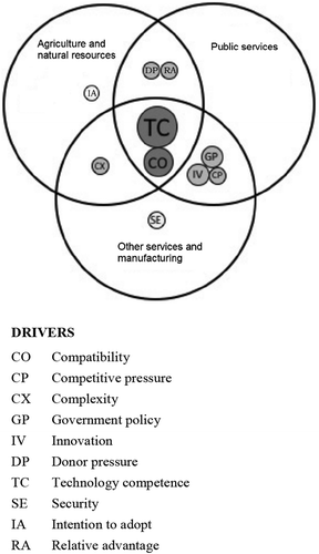
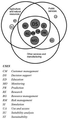
Figure 2. Sharing of uses by the main sector (size of uses, represented as shaded circles, denotes frequency of appearance in the literature).
Cases of reported GIT use are very diverse and numerous, and it is difficult to construct a complete overview of all the possible uses and motivations. The review below offers relevant examples found in the scholarly literature to illustrate the importance and widespread use of GIT in society.
3.1. Agriculture and natural resources
presents the GIT drivers and uses for organizations in the fields of agriculture and natural resources. In the agricultural sector, the crop suitability issue is leading many organizations (that deal with land) to adopt GIT. The need of this sector (to improve the understanding of land and productivity related variables) is crucial.
*Legend for (For a definition of the concepts, please see Annex 2).
Studies developed in the agriculture sector point out some examples and practices. Zolekar and Bhagat (Citation2015) and Chen, Yu, and Khan (Citation2010) used a combination of GIS and RS tools to analyze soil suitability for agriculture and rainwater harvesting. Mkiramwinyi et al. (Citation2009) and VoPham et al. (Citation2015) used GIT tools to estimate agriculture pesticide exposure, and Zhu, Zhang, and Sun (Citation2009) used GIT tools to improve precision agriculture by providing detailed spatial information on soil characteristics. On the physical side, GIT can provide support in soil analysis (Bandyopadhyay et al. Citation2009), and can predict soil erosion hazard through a combination of the universal soil loss equation and GIS tools (Mati et al. Citation2000).
In the environmental and natural resources sector, van Westen (Citation2013) reported that the adoption of GIT has been motivated to implement disaster risk management procedures, Mohammed et al. (Citation2015) adopted it to avoid heavy losses in productive land, environmental degradation, and biodiversity conservation (Swetnam and Reyers Citation2011). Other related studies include the management of earthquake damage through web-based mapping services and management of urban forestry (Zook et al. Citation2010; Tasoulas et al. Citation2013). Millock, Xabadia, and Zilberman (Citation2012) refer the reason of adopting GIT to the management of externalities (pollution) generated by automobiles through a combination of land based sensors and RS tools. Quite a large number of other application related uses are found in the literature, including the identification of sustainable urban development in Tehran (Javadian, Shamskooshki, and Momeni Citation2011), forestry management in India (Michael, Sahay, and Walsham Citation2001), improvement of the evaluation of landfill suitability in Iran (Javaheri et al. Citation2006), land administration (Puri and Sahay Citation2003; Karikari, Stillwell, and Carver Citation2005; Kamusoko et al. Citation2009), land use change in Tanzania (Haule, Mlozi, and Mulengera Citation2009), and mineral resource management (Pactwa, Blachowski, and Górniak-Zimroz Citation2015).
In the marine resources sector, the adoption of GIT has been motivated to address a lack of efficient methods for monitoring and managing marine environment processes and resources (Kairo, Kivyatu, and Koedam Citation2002; Kulawiak, Chybicki, and Moszynski Citation2010; Mahboubi et al. Citation2015; Nunes and Almeida Citation2011), to control critical life habitats (Wright and Heyman Citation2008), and to map the coral reef marine ecosystem (Levine and Feinholz Citation2015). Gold and Condal (Citation1995), Nath et al. (Citation2000) introduced GIT to support aquaculture and manage pollution crises in coastal and ocean regions of Europe (oil spills). Finally, Claus et al. (Citation2014) calls for the need to standardize marine geographic names (seas, ocean basins, ridges, seamounts) and boundaries through the use of an open application that will link names to information and maps with geographic location, as well as the need to have a web-based information system to improve management (Tuama and Hamre Citation2007).
3.2. Public service
shows GIT drivers and uses in public service organizations. Technology policies in the government sector are leading to the adoption and use of GIT, especially because governments wish to promote and encourage citizen participation, for example, in urban planning and re-development (Rambaldi et al. Citation2006; Moody Citation2007; Musakwa and van Niekerk Citation2015). Some examples of these actions can be urban governance (Ramadhan, Sensuse, and Arymurthy Citation2011), and management of urban violence (Abdulaal Citation2009) with the help of geo-referencing in crime events. On the implementation side, Yomralioglu (Citation2002), Abbott (Citation2003), Nasirin and Birks (Citation2003), Liu and Wei (Citation2010), Nourani, Saenz, and Castreghini (Citation2011) notice in these technologies the opportunity to integrate and link existing government infrastructures and platforms (e-Government) and make information more suitable for network transactions.
Table 2. GIT adoption in organizations in public service.
The education sector has been one of those that have actively adopted GIT. The capability to offer innovation and compatibility increases students’ productivity by providing virtual environments and rapid problem solving (Balram and Dragićević Citation2008; Korucu Citation2012). There are similar views applied technologies as tools to help students acquire critical thinking, spatial skills and social skills (Alibrandi and Palmer-Moloney Citation2001; Lloyd Citation2001; Zietsman Citation2002; Lateh and Muniandy Citation2010; Kim and Bednarz Citation2011; Musakwa Citation2017). Furthermore, Yin (Citation2010), Demirci, Karaburun, and Ünlü (Citation2013), Hwang (Citation2013), and Hong (Citation2014) emphasize the potentiality of these technologies to create a good learning environment for students and teachers. Because of their potentialities, GITs are capable of going beyond the classroom and being used in comparative studies as tools to test potential new teaching methods versus old ones (Amade and Painho Citation2011).
The health sector also has been among those that have actively adopted GIT, the reason lies in the interest in simulation and ability to predict disease outbreaks and spread (epidemiology). McLafferty (Citation2003) and Joyce (Citation2009) reported the use of GIT to improve support in health care delivery, Mahmoud et al. (Citation2015) mentioned that these tools could build a spatial decision-making support system for hospitals to monitor disease. Other examples include epidemiological studies and deployment of emergency services (Kistemann, Dangendorf, and Schweikart Citation2002). Analysis and understanding of the relationship between geography and disease are probably the main reason for GIT use in the health sector for research, simulation and monitoring (Patel and Waters Citation2012). On other hand, one of the factors that has been identified as a constraint for GIT use in health is its cost, and thus Abubakar et al.(Citation2014) pointed out the need to analyze how open-source GIT tools can provide feasible solutions for data visualization in the health care system and also provided patient record information through atlas database systems built with GIT (Cowper et al. Citation2004).
* Legend for .
3.3. Other services and manufacturing
The GIT drivers and uses within organizations in other services and manufacturing are presented in . The banking sector is using GIT to improve customer management, decision support, prediction, and risk management. This adoption has been motivated by current problems that banks are facing, namely competition (MacDonald Citation2001), financial fraud (Ngai et al. Citation2011), poor customer satisfaction and retention (Jafrullah and Uppuluri Citation2003), loan losses and a lack of decision-making mechanisms in distributing loans (Ajah and Inyiama Citation2011; Gabriela, Laurenţiu, and Simona Citation2010).
Table 3. GIT adoption in organizations in other services and manufacturing.
Competitive pressure is leading the manufacturing sector to use GIT. This is the case for planners who need to understand and use these tools to meet their professional requirements (Drummond and French Citation2008) and for business people to whom these technologies are crucial, especially if the activities are related to space and location management (Freire Citation2004). The construction of these tools is imperative to solve engineering problems related to spatial data (complex visualizations, integration of information, route planning, cost estimation and others) (Bansal Citation2007).
In the transport and communication sector the use of GIT has been motivated by the lack of appropriate decision support systems to mitigate communication network damage (Kawamura et al. Citation2014; Dorosh et al. Citation2012). Chen, Wu, and Tri (Citation2012) point to problems related to communications with network coverage that have been solved with a GIS model to predict network coverage systems. Ma et al. (Citation2009) and Mahesh, Zellner, and Zielinski (Citation2011) justify GIT use with the need to manage the highway network transportation system, which must respond to an increasing population and number of vehicles, and with urban sprawl; as well as with the safe transportation of dangerous freights in safe conditions (Batarlienė Citation2007).
* Legend for .
3.4. Analysis of GIT adoption in organizations and society
The literature reviewed above indicates the pervasive use of GIT in society and how this technology traverses a very large range of economic sectors in the private and public domains. It also shows that these technologies are used worldwide, although the scientific literature for Africa in this area is very scarce. A closer analysis of the different GIT drivers and uses leads to a summary of GIT adoption factors that can help to explain and understand the reasons why organizations take on GIT.
It is clear that public and private organizations are looking to use the spatial domain to improve productivity and performance, predict unusual situations, reduce losses, increase customer satisfaction and face competition. The drivers, indirectly extracted from the text content analysis of the literature, motivating organizations from different sectors to use GIT are: compatibility, competitive pressure, complexity, donor pressure, government policy, intention to adopt, innovation, relative advantage, security and technology competence as shown in to .
shows how these drivers are shared among the main domains. TC and CO are the most common drivers found and are shared by the three domains. DP and RA are driving public services and agriculture and natural resources, while GP, together with IV and CP, are shared by public services and other services and manufacturing. Security seems to be a driver mostly connected to other services and manufacturing.
Most of the uses identified in the literature are shared by the three domains (), the most important ones (i.e. those occurring most frequently in the literature review) being DS, MO, RG, and PR. ED is mostly utilized, as expected by the public services, which includes the education and research field, and, to a certain extent by the other services and manufacturing domain. Public services have an emphasis on UA and agriculture and natural resources on SU and ST.
In this section we have made an overview of the drivers and uses that are leading organizations to adopt GIT identified through a qualitative analysis of scientific literature. The drivers and uses for GIT identified in this work provide a basis for the further development of a quantitative adoption study.
4. GIT use in Mozambique – state of affairs
In its master plan Mozambican government supports the use of technology to improve the current scenario and move the country forward (Moçambique, Republica de Citation2010). The World Bank strategy for African countries resides in supporting them in their transformation through country strategies. The strategy lies heavily on sectors like manufacturing, agriculture, transportation, education, health, and ICT. A priority of the World Bank is to focus on reforms and public investments including infrastructure development (World Bank Citation2011).
In what follows we analyze the results of the survey from Mozambican organizations. We will analyze the same sectors as those found in the literature and use Mozambique as a case study of GIT adoption in developing countries. GIT has been widely used by both the public and private sectors since its 1980s. The Mozambican Government Moçambique, Republica de Citation2010) as well as the World Bank (World Bank Citation2011) have been reinforcing measures and program to invest more in ICT as well as in the need to develop GIT-based systems for use in funded projects.
4.1. Distribution of GIT by organization and activity sector
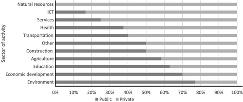
The proportion of public and private organizations that responded to the survey is balanced. depicts the weight of the public and private in the different sectors. The public sector has been more present in the environment, economic development, education, and agriculture whereas the private sector has more weight in the transportation, health, services, ICT, and natural resources. The proportion of organizations in the construction and other sectors is balanced. The other sector includes tourism management, logistics, public administration including road and urban planning, sports, and water management.
Figure 3. Distribution of public and private organizations by activity sector.
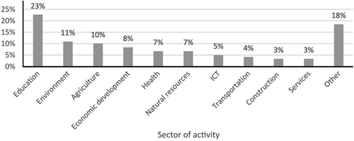
The analysis of the data collected from the questionnaire shows that organizations in the education sector with a percentage of 23% are those that represent most of the GIT use in Mozambique (see ) followed by environment (11%). Other important GIT users can be found in the agriculture (10%), economic development (8%), health (7%), and natural resources (7%) sectors. ICT, transportation, construction, and services sectors are also noteworthy although still in a very early stage of implementation. The other sector class (18%) includes other sectors less important in terms of GIT use such as tourism management, logistics, public administration including road and urban planning, sports, and water management, among others. For the sectors agriculture and environment, it is important to remark that Mozambique public policies are emphasizing the development of these two sectors (Moçambique, Republica de Citation2010) given their importance both as a main means of income and food production for the population. The agriculture sector absorbs 75% of the population of Mozambique (UN FAO Citation2015).
Figure 4. General use of GIT by sector.
The environment is facing many challenges such as climate change, biodiversity conservation, among others, which are influencing the productivity of natural and semi-natural ecosystems (Tilman Citation2001). It is also noteworthy that transportation, construction, and services are the sectors with the least use of GIT among the respondents ().
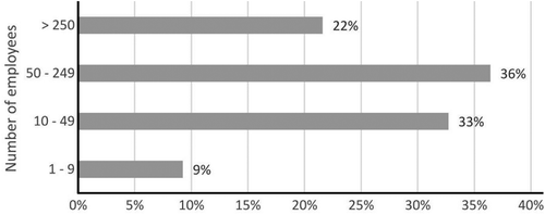
It seems that there is no relationship between organization size and GIT use. The percentage of GIT use by organization size is depicted in . The organizations were classified in terms of their number of employees (European Commission Citation2015). More than 50% of the organizations using GIT have over 50 employees. However, it is important to note that GIT use is spread throughout all organizational sizes.
Figure 5. Percentage of GIT use by organization size.
4.2. Evolution and intensity of GIT use
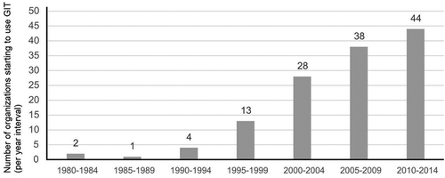
It is possible to find in that the organizations started to intensify the use of GIT from 1995: in the period of 2010−2014, the number of new organizations using GIT reached 44; 1995−2014, the number of organizations using GIT increases very quickly in line with world evolution of GIT use (Henttu, Izaret, and Potere Citation2012). Before the year 1995, the use of these technologies was very rare and almost insignificant. It is also clear that between 1980 and 1995 organizations were stagnant in terms of new technology approaches.
Figure 6. Evolution of GIT use in Mozambican organizations.
Crossing data between sectors of activity and type of most used technologies is illustrated the . All three GIT types, GIS, GPS, and RS, are led by the education sector. The GIS technology is, as mentioned, topped by the education sector. A second group of sectors in intensity of GIS use includes the environment, agriculture, natural resources, economic development, and ICT. The remaining sectors form a group of low GIS use (five or fewer organizations per sector). In the same the way, RS intensity is led by education followed by natural resources, environment, and ICT, leaving all the other sectors in a large group of low use intensity (fewer than five organizations per sector). Finally GPS, the most recent of GIT technologies, is mostly used by the education and environment sectors closely followed by the agriculture, natural resources, and ICT, the remaining forming a group of lower use intensity (five or fewer organizations per sector). The other class sector includes organizations using complementary technologies, of which Google Earth, Google Maps and automatic information system are examples. GIS and GPS are the most frequently used technologies in all sectors. Independently of the intensity of use all sectors share a similar pattern of the technology mix use.
Figure 7. Intensity of GIT type by sector.
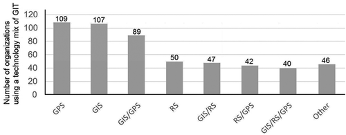
Using a technology mix of GIT creates synergies and efficiency in works. When looking at the technology mix (), it is possible to find that the most common technologies (GPS and GIS) used by the organizations are also those that are used together more frequently. Other mixes also exist and about one third of the organizations use some kinds of mix including GIS/RS and RS/GPS or a mixture of the three (GIS/GPS/RS). A group of organizations (46) actually use some or all of the identified GIT technologies with complementary ones.
Figure 8. GIT mix use.
4.3. Summary of GIT use in Mozambique
Analysis of the data collected from the questionnaire shows that GIT is being used by many and diverse sectors in Mozambique. The proportion of public and private organizations that responded to the survey is balanced. The public sector has been more present in the environment, economic development, education, and agriculture, whereas the private sector has more weight in transportation, health, services, ICT, and natural resources (). Organizations in the education sector with a percentage of 23% are those that represent most of the GIT use in Mozambique () followed by environment (11%). More than half of the organizations using GIT have more than 50 employees (). Organizations started to intensify the use of GIT from year 1995 and in year 2014 the number of new organizations using GIT reached 44 (). All three GIT types, GIS, GPS, and RS are led by the education sector (). However, it is important to note that GIT use is spread throughout all organizational sizes and the technologies most used are GIS and GPS in all sectors.
5. Conclusions
This paper has analyzed the main drivers and uses of GIT revealed in a literature review, and the current situation in Mozambique in terms of GIT uses. The literature review showed that the main drivers of GIT uses in organizations are compatibility, competitive pressure, complexity, donor pressure, government policy, intention to adopt, innovation, relative advantage, security, and technology competence (with compatibility and technology competence being the main ones). Organizations of the public and private sectors use GIT for customer management, decision support, education, monitoring, prediction, research, resource management, risk management, simulation, suitability analysis, sustainability, use, and access.
The results of the questionnaire revealed that GIT is being used as well by many and diverse sectors in Mozambique. The public sector has been more present in the environment, economic development, education, and agriculture, whereas the private sector has more weight in transportation, health, services, ICT, and natural resources. Organizations in the education sector represent the largest sector of GIT use in Mozambique followed by the environment. GIT application started to intensify since 1995 with 44 new organizations using GIT in the period 2010−2014. All three GIT types (GIS, GPS, and RS) are led by the education sector. However, it is important to note that GIT use is spread throughout all organizational sizes, and the most used technologies are GIS and GPS in all sectors.
This first study gave an overview of the state of affairs of GIT used in Mozambique, and identified a number of drivers and uses that can form the support to develop a conceptual model inspired on some of the results of the current research.
There are many models on information technology adoption that are operating at individual and organization level, and have been studied and developed over the years. The most important theories operating at organization level are the diffusion of innovation (DOI) theory (Rogers Citation2002), technology, organization and environment (TOE) framework (Tornatzky and Fleischer Citation1990) and organizational theory (Powell and Dimaggio Citation1991). The DOI theory explains how new ideas spread through cultures using communication channels. The TOE framework seeks to explain how organizations can reach the right equilibrium between internal and external factors. Finally the organizational theory emphasizes the aspects related to social culture (norms, routines, and rules) and how they become established as authoritative guidelines for social behavior. As future research, we suggest using the remaining answers to the questionnaire to test the existing adoption models at the organization level and enriching them with the findings of the current study to understand GIT adoption in Mozambique.
Additional information
Funding
Notes on contributors
Nelson Amade
Nelson Amade obtained his Bachelor’s degree from the Faculty of Tourism Management and Information Technology, Catholic University of Mozambique in 2008 and a Master’s degree in 2011. He is currently a PhD candidate in the field of Information Management at the NOVA Information Management School (NOVA IMS) of the Universidade Nova de Lisboa.
Marco Painho
Marco Painho is a full professor at the NOVA Information Management School (NOVA IMS) of the Universidade Nova de Lisboa and the coordinator of the Masters Programs in Geospatial Technologies and Geographic Information Systems and Science. He holds a PhD in Geography from the University of California in Santa Barbara. His research interests include Geographical Information Systems and Science, (Spatial) Decision Support Systems, Data Integration, Spatial Analysis, User Generated (Spatial) Content, Information Infrastructures, New Technology Implementation, GIS Education and Distance Learning (e-learning). Additional detail can be found at http://www.novaims.unl.pt/docentes-investigacao-docentes?d=3.
Tiago Oliveira
Tiago Oliveira is an associate professor at the NOVA Information Management School (NOVA IMS). His research interests include technology adoption, digital divide and privacy. He has published papers in several academic journals and conferences, including the Information & Management, Decision Support Systems, Computers in Human Behavior, Journal of Business Research, Information Systems Frontiers, International Journal of Information Management, Journal of Global Information Management, Industrial Management & Data Systems, Computers in Industry, International Journal of Accounting Information Systems, etc. Tiago has authored more than 100 scientific articles in Journals and conference proceedings and has more than 3000 citations (https://scholar.google.com/citations?user=RXwZPpoAAAAJ).
References
- Abbott, J. 2003. “The Use of GIS in Informal Settlement Upgrading: Its Role and Impact on the Community and on Local Government.” Habitat International 27 (4): 575–593. doi:10.1016/S0197-3975(03)00006-7.
- Abdulaal, W. A. 2009. “Framework for Enterprise GIS for Saudi Municipalities.” International Journal of Geographical Information Science 23 (6): 687–702. doi:10.1080/13658810701378838.
- Abubakar, B., K. Honest, S. Bakar, and H. Sleiman. 2014. “Adoption of Free Open Source Geographic Information System Solution for Health Sector in Zanzibar Tanzania.” Journal of Health Informatics 8 (1): 1–11. http://jhidc.org/index.php/jhidc/article/view/110.
- Ajah, I., and C. Inyiama. 2011. “Loan Fraud Detection and IT-based Combat Strategies.” Journal of Internet Banking and Commerce 16(2): 1. Special section.
- Alibrandi, M., and J. Palmer-Moloney. 2001. “Making a Place for Technology in Teacher Education with Geographic Information Systems (GIS).” Contemporary Issues in Technology and Teacher Education 1 (4): 483–500. http://www.editlib.org/p/10739.
- Amade, N., and M. Painho. 2011. “Google Earth Como Ferramenta Didáctica - Um Estudo de Caso Numa Escola Secundária.” REID, 1–14. http://reid.ucm.ac.mz/index.php/reid/article/view/6.
- Balram, S., and S. Dragićević. 2008. “Collaborative Spaces for GIS-based Multimedia Cartography in Blended Environments.” Computers and Education 50 (1): 371–385. doi:10.1016/j.compedu.2006.07.004.
- Bandyopadhyay, S., R. K. Jaiswal, V. S. Hegde, and V. Jayaraman. 2009. “Assessment of Land Suitability Potentials for Agriculture Using a Remote Sensing and GIS Based Approach.” International Journal of Remote Sensing 30 (4): 879–895. doi:10.1080/01431160802395235.
- Bansal, V. K. 2007. “Potential of GIS to Find Solutions to Space Related Problems in Construction Industry.” Proceedings of World Academy of Science Engineering Technology 136119 (8): 307–310.
- Batarlienė, N. 2007. “Implementation of Advanced Technologies and Other Means in Dangerous Freight Transportation.” Pažangių Technologijų Ir Kitų Priemonių Diegimas Vežant Pavojinguosius Krovinius 22 (4): 290–295. doi:10.1080/16484142.2007.9638144.
- Chan, F. T. S., and A. Y. L. Chong. 2012. “A SEM-Neural Network Approach for Understanding Determinants of Interorganizational System Standard Adoption and Performances.” Decision Support Systems 54 (1): 621–630. doi:10.1016/j.dss.2012.08.009.
- Chen, X., H. Wu, and T. M. Tri. 2012. “Field Strength Prediction of Mobile Communication Network Based on GIS.” Geo-Spatial Information Science 15 (3): 199–206. doi:10.1080/10095020.2012.720457.
- Chen, Y., J. Yu, and S. Khan. 2010. “Spatial Sensitivity Analysis of Multi-Criteria Weights in GIS-based Land Suitability Evaluation.” Environmental Modelling and Software 25 (12): 1582–1591. doi:10.1016/j.envsoft.2010.06.001.
- Chong, A. Y. L., and F. T. S. Chan. 2012. “Structural Equation Modeling for Multi-Stage Analysis on Radio Frequency Identification (RFID) Diffusion in the Health Care Industry.” Expert Systems with Applications 39 (10): 8645–8654. doi:10.1016/j.eswa.2012.01.201.
- Chrisman, N. 2002. Exploring Geographic Information Systems. New York: John Wiley and Sons.
- Claus, S., N. De Hauwere, B. Vanhoorne, P. Deckers, F. Souza Dias, F. Hernandez, and J. Mees. 2014. “Marine Regions: Towards a Global Standard for Georeferenced Marine Names and Boundaries.” Marine Geodesy 37 (2): 99–125. doi:10.1080/01490419.2014.902881.
- Cooper, R. B., and R. W. Zmud. 1990. “Information Technology Implementation Research: A Technological Diffusion Approach.” Management Science 36 (2): 123–139. doi:10.1287/mnsc.36.2.123.
- Cowper, D., W. Yu, M. Kuebeler, J. D. Kubal, L. M. Manheim, and B. A. Ripley. 2004. “Using GIS in Government: An Overview of the VHA’s Healthcare Atlas, FY-2000.” Journal of Medical Systems 28 (3): 257–269. doi:10.1023/B:JOMS.0000032843.52406.2f.
- Demirci, A., A. Karaburun, and M. Ünlü. 2013. “Implementation and Effectiveness of GIS-based Projects in Secondary Schools.” Journal of Geography 112 (5): 214–228. doi:10.1080/00221341.2013.770545.
- Dong-Ju, C. 2013. “Whither Should ICT4D Go in Africa?” African Affairs 33 (1): 227–246.
- Dorosh, P., H. G. Wang, L. You, and E. Schmidt. 2012. “Road Connectivity, Population, and Crop Production in Sub-Saharan Africa.” Agricultural Economics 43 (1): 89–103. doi:10.1111/j.1574-0862.2011.00567.x.
- Drummond, W. J., and S. P. French. 2008. “The Future of GIS in Planning: Converging Technologies and Diverging Interests.” Journal of the American Planning Association 74 (2): 161–174. doi:10.1080/01944360801982146.
- European Commission. 2015. “What Is an SME?” http://ec.europa.eu/growth/smes/business-friendly-environment/sme-definition/index_en.htm.
- Foster, V., and C. Dominguez. 2011. “Zambia’s Infrastructure: A Continental Perspective.” Policy Research Working Papers. World Bank. doi: 10.1596/1813-9450-5599.
- Freire, N. 2004. “O Geonegócio - as Geotecnologias E a Emergência de Novos Mercados Em Regiões Periféricas: O Caso de Maceió - AL.” http://hdl.handle.net/123456789/6070. (in Portuguese)
- Gabriela, D., D. Laurenţiu, and M. Simona. 2010. “Geographical Information Systems - Applicability in Investments and Banking.” Annals of the University of Craiova, Economic Sciences Series 2 (38): 1–8.
- Ghobakhloo, M., D. Arias-Aranda, and J. Benitez-Amado. 2011. “Adoption of E-Commerce Applications in SMEs.” Industrial Management and Data Systems 111 (8): 1238–1269. doi:10.1108/02635571111170785.
- Gold, C. M., and A. R. Condal. 1995. “A Spatial Data Structure Integrating GIS and Simulation in A Marine Environment.” Marine Geodesy 18 (3): 213–228. doi:10.1080/15210609509379757.
- Gutiérrez, J., R. González, and G. Gómez. 1996. “The European High-Speed Train Network.” Journal of Transport Geography 4 (4): 227–238. doi:10.1016/S0966-6923(96)00033-6.
- Harrison, T., T. A. Pardo, J. R. Gil-Garcia, F. Thompson, and D. Juraga. 2007. “Geographic Information Technologies, Structuration Theory, and the World Trade Center Crisis.” Journal of the American Society for Information Science and Technology 58 (14): 2240–2254. doi:10.1002/asi.20695.
- Harvey, F., and N. Chrisman. 1998. “Boundary Objects and the Social Construction of GIS Technology.” Environment and Planning A 30 (9): 1683–1694. doi:10.1068/a301683.
- Haule, C., M. Mlozi, and M. Mulengera. 2009. “The Pattern and Magnitude of Land Use/Cover Change in Three Wards of Ludewa District, Tanzania and Its Implications to Smallholder Farmers’ Livelihoods.” African Affairs 25 (1): 31–58.
- Hendriks, P. H. J. 2000. “An Organizational Learning Perspective on GIS.” International Journal of Geographical Information Science 14 (4): 373–396. doi:10.1080/13658810050024296.
- Henttu, H., J. M. Izaret, and D. Potere. 2012. “(Boston Consulting Group) Geospatial Services: A $1.6 Trillion Growth Engine for the U.S. Economy.” https://www.bcg.com/documents/file109372.pdf.
- Hong, J. E. 2014. “Promoting Teacher Adoption of GIS Using Teacher-Centered and Teacher-Friendly Design.” Journal of Geography 113 (4): 139–150. doi:10.1080/00221341.2013.872171.
- Horler, D., and J. Barber. 1981. Plants and the Daylight Spectrum: Principles of Remote Sensing of Plants. London: Academic Press.
- Hwang, S. 2013. “Placing GIS in Sustainability Education.” Journal of Geography in Higher Education 37 (2): 276–291. doi:10.1080/03098265.2013.769090.
- Jafrullah, M., and S. Uppuluri. 2003. “An Integrated Approach for Banking GIS.” Paper Presented at the Map India 2003 Conference, India, New Delhi, January 28–31.
- Jankowski, P., and T. Nyerges. 2001. GIS for Group Decision Making. Boca Raton: CRC Press.
- Javadian, M., H. Shamskooshki, and M. Momeni. 2011. “Application of Sustainable Urban Development in Environmental Suitability Analysis of Educational Land Use by Using AHP and GIS in Tehran.” Procedia Engineering 21: 72–80. doi:10.1016/j.proeng.2011.11.1989.
- Javaheri, H., T. Nasrabadi, M. H. Jafarian, G. R. Rowshan, and H. Khoshnam. 2006. “Site Selection of Municipal Solid Waste Landfills Using Analytical Hierarchy Process Method in a Geographical Information Technology Environment in Giroft.” Iranian Journal of Environmental Health, Science and Engineering 3 (3): 177–184.
- Joyce, K. 2009. “‘To Me It’S Just Another Tool to Help Understand the Evidence’: Public Health Decision-Makers’ Perceptions of the Value of Geographical Information Systems (GIS).” Health and Place 15 (3): 831–840. doi:10.1016/j.healthplace.2009.01.004.
- Kairo, J. G., B. Kivyatu, and N. Koedam. 2002. “Application of Remote Sensing and GIS in the Management of Mangrove Forests within and Adjacent to Kiunga Marine Protected Area, Lamu, Kenya.” Environment, Development and Sustainability 4 (2): 153–166. doi:10.1023/A:1020890711588.
- Kamusoko, C., M. Aniya, B. Adi, and M. Manjoro. 2009. “Rural Sustainability under Threat in Zimbabwe – Simulation of Future Land Use/Cover Changes in the Bindura District Based on the Markov-Cellular Automata Model.” Applied Geography 29 (3): 435–447. doi:10.1016/j.apgeog.2008.10.002.
- Kaplan, E. D., and C. Hegarty. 2005. Understanding GPS: Principles and Applications. 2nd ed. Boston: Artech House.
- Karikari, I., J. Stillwell, and S. Carver. 2005. “The Application of GIS in the Lands Sector of a Developing Country: Challenges Facing Land Administrators in Ghana.” International Journal of Geographical Information Science 19 (3): 343–362. doi:10.1080/13658810412331280149.
- Kawamura, Y., A. M. Dewan, B. Veenendaal, M. Hayashi, T. Shibuya, I. Kitahara, H. Nobuhara, and K. Ishii. 2014. “Using GIS to Develop a Mobile Communications Network for Disaster-Damaged Areas.” International Journal of Digital Earth 7 (4): 279–293. doi:10.1080/17538947.2013.808277.
- Kim, M., and R. Bednarz. 2011. “GIS Education for Teachers in South Korea: Who Participates and Why?” Korean Geographical Society 46 (3): 382–395. http://www.kgeography.or.kr/homepage/kgeography/www/old/publishing/journal/46/03/11.PDF.
- Kistemann, T., F. Dangendorf, and J. Schweikart. 2002. “New Perspectives on the Use of Geographical Information Systems (GIS) in Environmental Health Sciences.” International Journal of Hygiene and Environmental Health 205 (3): 169–181. doi:10.1078/1438-4639-00145.
- Korucu, M. G. 2012. “GIS and Types of GIS Education Programs.” Procedia - Social and Behavioral Sciences 46: 209–215. doi:10.1016/j.sbspro.2012.05.095.
- Kulawiak, M., A. Chybicki, and M. Moszynski. 2010. “Web-Based GIS as a Tool for Supporting Marine Research.” Marine Geodesy 33 (2–3): 135–153. doi:10.1080/01490419.2010.492280.
- Lateh, H., and V. Muniandy. 2010. “ICT Implementation among Malaysian Schools: GIS, Obstacles and Opportunities.” Procedia - Social and Behavioral Sciences 2 (2): 2846–2850. doi:10.1016/j.sbspro.2010.03.426.
- Levine, A. S., and C. L. Feinholz. 2015. “Participatory GIS to Inform Coral Reef Ecosystem Management: Mapping Human Coastal and Ocean Uses in Hawaii.” Applied Geography 59: 60–69. doi:10.1016/j.apgeog.2014.12.004.
- Liu, H. B., and Y. G. Wei. 2010. “The Application of Web GIS in e-Government.” Paper Presented at the IEEE International Conference on e-Business and e-Government, China, Guangzhou, May 7–9 doi: 10.1109/ICEE.2010.139.
- Lloyd, W. J. 2001. “Integrating GIS into the Undergraduate Learning Environment.” Journal of Geography 100 (5): 158–163. doi:10.1080/00221340108978443.
- Low, C., Y. Chen, and M. Wu. 2011. “Understanding the Determinants of Cloud Computing Adoption.” Industrial Management and Data Systems 111 (7): 1006–1023. doi:10.1108/02635571111161262.
- Ma, Y. C., Y. Zhou, M. Chowdhury, K. C. Wang, and R. Fries. 2009. “A Framework for Performance Evaluation of Communication Alternatives for Intelligent Transportation Systems.” Journal of Intelligent Transportation Systems 13 (3): 111–126. doi:10.1080/15472450903084212.
- MacDonald, E. H. 2001. “GIS in Banking: Evaluation of Canadian Bank Mergers.” Canadian Journal of Regional Science 24 (3): 419–442.
- Mahboubi, P., M. Parkes, C. Stephen, and H. M. Chan. 2015. “Using Expert Informed GIS to Locate Important Marine Social-Ecological Hotspots.” Journal of Environmental Management 160: 342–352. doi:10.1016/j.jenvman.2015.03.055.
- Mahesh, A., M. L. Zellner, and S. Zielinski. 2011. “Emerging Private Sector Roles in Urban Transport: A Case Study of an Innovative Telecom-GIS Solution in Bangalore.” Journal of Urban Technology 18 (3): 67–80. doi:10.1080/10630732.2011.615568.
- Mahmoud, M. S. A., M. Ibrahim, A. Magid, S. M. A. Abdullah, and N. M. El-Tayeb. 2015. “Development of Health Care Systems in Subareas of KSA Using GIS Concept.” Journal of Information Sciences and Computing Technologies 1 (1): 7–53. http://www.scitecresearch.com/journals/index.php/jisct/article/download/16/7.
- Mati, B. M., R. P. C. Morgan, F. N. Gichuki, J. N. Quinton, T. R. Brewer, and H. P. Liniger. 2000. “Assessment of Erosion Hazard with the USLE and GIS: A Case Study of the Upper Ewaso Ng’iro North Basin of Kenya.” International Journal of Applied Earth Observation and Geoinformation 2 (2): 78–86. doi:10.1016/S0303-2434(00)85002-3.
- McLafferty, S. L. 2003. “GIS and Health Care.” Annual Review of Public Health 24 (1): 25–42. doi:10.1146/annurev.publhealth.24.012902.141012.
- Michael, B., S. Sahay, and G. Walsham. 2001. “Information Technology and Social Transformation: GIS for Forestry Management in India.” The Information Society 17 (1): 5–20. doi:10.1080/019722401750067397.
- Millock, K., A. Xabadia, and D. Zilberman. 2012. “Policy for the Adoption of New Environmental Monitoring Technologies to Manage Stock Externalities.” Journal of Environmental Economics and Management 64 (1): 102–116. doi:10.1016/j.jeem.2012.02.004.
- Mkiramwinyi, F. O., B. P. Mbilinyi, P. T. K. Munishi, S. D. Tumbo, and M. C. S. Lalika. 2009. “Identification of Potential Sites for Rainwater Harvesting Using Remote Sensing and GIS in the Makanya River Catchment, Same District, Northern Tanzania.” African Affairs 25 (1): 169–184.
- Moçambique, Republica de. 2010. “Programa Quinquenal Do Governo Para 2010–2014.” http://www.mpd.gov.mz/index.php/documentos/instrumentos-de-gestao/programa-quinquenal-do-governo-pqg/2015-2019.
- Mohammed, K. S., Y. Elhadary, N. Samat, and N. Q. Omar. 2015. “GIS and Remote Sensing Techniques for Measuring Agriculture Land Loss in Balik Pulau Region of Penang State, Malaysia.” Asian Journal of Agriculture and Rural Development 5 (2): 30–41.
- Moody, R. 2007. “Electronic Government.” Paper Presented at the International Conference on Electronic Government, Regensburg, Germany, September 3–7. doi: 10.1007/978-3-540-74444-3.
- Moore, G. C., and I. Benbasat. 1991. “Development of an Instrument to Measure the Perceptions of Adopting an Information Technology Innovation.” Information Systems Research 2 (3): 192–222. doi:10.1287/isre.2.3.192.
- Musakwa, W. 2017. “Perspectives on Geospatial Information Science Education: An Example of Urban Planners in Southern Africa.” Geo-Spatial Information Science 20 (2): 201–208. doi:10.1080/10095020.2017.1339403.
- Musakwa, W., and A. van Niekerk. 2015. “Earth Observation for Sustainable Urban Planning in Developing Countries.” Journal of Planning Literature 30 (2): 149–160. doi:10.1177/0885412214557817.
- Nasirin, S., and D. F. Birks. 2003. “DSS Implementation in the UK Retail Organisations: A GIS Perspective.” Information and Management 40 (4): 325–336. doi:10.1016/S0378-7206(02)00015-0.
- Nath, S. S., J. P. Bolte, L. G. Ross, and J. Aguilar-Manjarrez. 2000. “Applications of Geographical Information Systems (GIS) for Spatial Decision Support in Aquaculture.” Aquacultural Engineering 23 (1–3): 233–278. doi:10.1016/S0144-8609(00)00051-0.
- Ngai, E. W. T., Y. Hu, Y. H. Wong, Y. Chen, and X. Sun. 2011. “The Application of Data Mining Techniques in Financial Fraud Detection: A Classification Framework and an Academic Review of Literature.” Decision Support Systems 50 (3): 559–569. doi:10.1016/j.dss.2010.08.006.
- Nkhoma, M. Z., and D. P. T. Dang. 2013. “Contributing Factors of Cloud Computing Adoption : A Technology - Organisation - Environment Framework Approach.” International Journal of Information Systems and Engineering 1 (1): 38–49. http://researchbank.rmit.edu.au/view/rmit:22196.
- Nourani, F., M. C. Saenz, and M. I. Castreghini. 2011. “Tecnologias de Informação Geográfica No Apoio À Tomada de Decisão Em Políticas Públicas de Controle Da Violência.” Revista Do Laboratório de Estudos Da Violência Da UNESP/Marília. (in Portuguese) http://200.145.171.5/revistas/index.php/levs/article/download/1659/1414.
- Nunes, C., and O. Almeida. 2011. “A Atuação Das Instituições Governamentais Na Atividade Pesqueira E O Uso de Geotecnologias Na Amazônia.” Formação Online 1 (18): 214–237. (in Portuguese) http://revista.fct.unesp.br/index.php/formacao/article/view/875/1088
- Oliveira, T., and M. Martins. 2011. “Literature Review of Information Technology Adoption Models at Firm Level.” The Electronic Journal Information Systems Evaluation 14 (1): 110–121.
- Pactwa, K., J. Blachowski, and J. Górniak-Zimroz. 2015. “GIS as a Support Tool in Regional Management of Rock Mineral Resources – Experiences from SW Poland.” Procedia Earth and Planetary Science 15: 488–494. doi:10.1016/j.proeps.2015.08.054.
- Patel, A., and N. Waters. 2012. Application of Geographic Information Systems: Chapter 16: Using Geographic Information Systems for Health Research. InTech. https://www.intechopen.com/books/application-of-geographic-information-systems/using-geographic-information-systems-for-health-research.
- Powell, W. W., and P. J. Dimaggio. 1991. The New Organizationalism in Organizational Analysis. Chicago: University of Chicago Press.
- Puri, S. K., and S. Sahay. 2003. “Participation through Communicative Action: A Case Study of GIS for Addressing Land/Water Development in India.” Information Technology for Development 10 (3): 179–199. doi:10.1002/itdj.1590100305.
- Ramadhan, A., D. I. Sensuse, and A. M. Arymurthy. 2011. “Assessment of GIS Implementation in Indonesian E-Government System.” Paper Presented at the IEEE International Conference on Electrical Engineering and Informatics, Indonesia, Bandung, July 17–19. doi: 10.1109/ICEEI.2011.6021515.
- Rambaldi, G., P. A. K. Kyem, M. McCall, and D. Weiner. 2006. “Participatory Spatial Information Management and Communication in Developing Countries.” The Electronic Journal of Information Systems in Developing Countries 25 (1): 1–9. doi:10.1002/j.1681-4835.2006.tb00162.x.
- Rogers, E. M. 2002. “Diffusion of Preventive Innovations.” Addictive Behaviors 27 (6): 989–993. doi:10.1016/S0306-4603(02)00300-3.
- Rogers, E. M. 2003. Diffusion of Innovations.5th ed. New York: Free Press. doi:10.1007/978-94-011-1771-5_2.
- Swetnam, R. D., and B. Reyers. 2011. “Meeting the Challenge of Conserving Africa’s Biodiversity: The Role of GIS, Now and in the Future.” Landscape and Urban Planning 100 (4): 411–414. doi:10.1016/j.landurbplan.2011.02.002.
- Tasoulas, E., G. Varras, I. Tsirogiannis, and C. Myriounis. 2013. “Development of a GIS Application for Urban Forestry Management Planning.” Procedia Technology 8: 70–80. doi:10.1016/j.protcy.2013.11.011.
- Tilman, D. 2001. “Forecasting Agriculturally Driven Global Environmental Change.” Science 292 (5515): 281–284. doi:10.1126/science.1057544.
- Tornatzky, L., and M. Fleischer. 1990. The Process of Technology Innovation. Lexington, MA: Lexington Books.
- Tuama, É. Ó., and T. Hamre. 2007. “Design and Implementation of a Distributed GIS Portal for Oil Spill and Harmful Algal Bloom Monitoring in the Marine Environment.” Marine Geodesy 30 (1–2): 145–168. doi:10.1080/01490410701296671.
- UN FAO. 2015. “FAO in Mozambique.” http://www.fao.org/mozambique/fao-in-mozambique/en/.
- van Westen, C. J. 2013. “3.10 Remote Sensing and GIS for Natural Hazards Assessment and Disaster Risk Management.” Treatise on Geomorphology 3: 259–298. doi:10.1016/B978-0-12-374739-6.00051-8.
- VoPham, T., J. P. Wilson, D. Ruddell, T. Rashed, M. M. Brooks, J. M. Yuan, E. O. Talbott, C. C. H. Chang, and J. L. Weissfeld. 2015. “Linking Pesticides and Human Health: A Geographic Information System (GIS) and Landsat Remote Sensing Method to Estimate Agricultural Pesticide Exposure.” Applied Geography 62: 171–181. doi:10.1016/j.apgeog.2015.04.009.
- Wang, Y. M., Y. S. Wang, and Y. F. Yang. 2010. “Understanding the Determinants of RFID Adoption in the Manufacturing Industry.” Technological Forecasting and Social Change 77 (5): 803–815. doi:10.1016/j.techfore.2010.03.006.
- World Bank. 2011. “Africa’s Future and the World Bank’s Support to It.” http://siteresources.worldbank.org/INTAFRICA/Resources/AFR_Regional_Strategy_3-2-11.pdf.
- World Bank. 2016. “GDP Growth (Annual %).” http://data.worldbank.org/indicator/NY.GDP.MKTP.KD.ZG/countries/MZ?display=graph.
- Wright, D. J., and W. D. Heyman. 2008. “Introduction to the Special Issue: Marine and Coastal GIS for Geomorphology, Habitat Mapping, and Marine Reserves.” Marine Geodesy 31 (4): 223–230. doi:10.1080/01490410802466306.
- Yin, L. 2010. “Integrating 3D Visualization and GIS in Planning Education.” Journal of Geography in Higher Education 34 (3): 419–438. doi:10.1080/03098260903556030.
- Yomralioglu, T. 2002. “GIS Activity in Turkey.” International Symposium on GIS, Turkey Istanbul, September 23–26. doi:10.1044/1059-0889(2002/er01)
- Zhu, D. H., Y. P. Chang, and J. J. Luo. 2016. “Understanding the Influence of C2C Communication on Purchase Decision in Online Communities from a Perspective of Information Adoption Model.” Telematics and Informatics 33 (1): 8–16. doi:10.1016/j.tele.2015.06.001.
- Zhu, K., S. Dong, S. X. Xu, and K. L. Kraemer. 2006. “Innovation Diffusion in Global Contexts: Determinants of Post-Adoption Digital Transformation of European Companies.” European Journal Of Information Systems 15 (6): 601–616. doi:10.1057/palgrave.ejis.3000650.
- Zhu, K., and K. L. Kraemer. 2005. “Post-Adoption Variations in Use and Value of e-Business by Organizations : Cross-Country Evidence from the Retail Industry.” Information Systems Research 16 (1): 61–84. doi:10.1287/Isre.1050.0045.
- Zhu, K., K. L. Kraemer, and S. Xu. 2006. “The Process of Innovation Assimilation by Firms in Different Countries: A Technology Diffusion Perspective on e-Business.” Management Science 52 (10): 1557–1576. doi:10.1287/mnsc.1050.0487.
- Zhu, Z., R. Zhang, and J. Sun. 2009. “Research on GIS-based Agriculture Expert System.” Paper Presented at the WRI World Congress on Software Engineering, China, Xiamen, May 19–21. doi: 10.1109/WCSE.2009.104.
- Zietsman, H. L. 2002. “Geographic Information Science in South Africa.” South African Geographical Journal 84 (1): 30–37. doi:10.1080/03736245.2002.9713753.
- Zolekar, R. B., and V. S. Bhagat. 2015. “Multi-Criteria Land Suitability Analysis for Agriculture in Hilly Zone: Remote Sensing and GIS Approach.” Computers and Electronics in Agriculture 118 (C): 300–321. doi:10.1016/j.compag.2015.09.016.
- Zook, M., M. Graham, T. Shelton, and S. Gorman. 2010. “Volunteered Geographic Information and Crowdsourcing Disaster Relief: A Case Study of the Haitian Earthquake.” World Medical and Health Policy 2 (2): 7–33. doi:10.2202/1948-4682.1069.
Appendix
Annex 1. List of questions used in article (translation to English, between brackets and in italics)
Caracterização da instituição (Organizational description)
1. Qual o sector de actividade da sua instituição (seleccione por favor uma das opções abaixo)?
(What is the activity sector of your organization (select one of the options below)?
2. Quais as Tecnologias de Informação Geográfica (TIG) utilizadas na sua instituição? (What geographic information technologies (GIT) are used in your organization?)
Sistema de informação geográfica (Geographic information systems (GIS))
Deteção remota (Remote sensing)
Sistemas de posicionamento global (Global Positioning Systems (GPS))
Outras (especifique) (Other (Specify))
Nenhuma (None)
3. Na sua instituição utiliza as seguintes TIG: (In your organization, geographic information technologies are used)
No computador pessoal (In a personal computer)
Na Web/Internet (On the Web/Internet)
4. Há quantos anos a sua instituição utiliza TIG? (For how many years has your organization been using GIT?)
5. Qual o número de trabalhadores da instituição (aproximadamente)? (How many people, approximately work in your organization?)
6. Aproximadamente qual o volume de negócios anual da sua instituição em Moçambique? (What the annual trade volume of your organization?)
Até 80.000.00 MZN (Up to…)
81.000.00 MZN 400.000.00 MZN
401.000.001 MZN 2.000.000.00 MZN
Superior a 2.000.000.000.001 MZN (Above…)
Não aplicável a instituições do Estado (Does not apply to governmental organizations)
7. Qual o cargo que ocupa na sua instituição? (What is your position in the organization?)
8. Caso esteja interessado em receber os resultados deste estudo, indique por favor o seu e-mail: (If you are interested in receiving the results of the study please provide your email)