
ABSTRACT
Over the last 20 years, Africa has witnessed a slow but steady advancement in space-based technologies as they are increasingly recognized as an essential tool for decision-making that can leapfrog African development. A critical review on the outcome of a survey questionnaire focused on African private sector industries and universities, services and education/training in EO and Geo-Information Sciences, combined with literature review, and personal contacts reveal optimism for success in four sectors. These include the public sector (Government ministries and departments); Academic institutions (universities/colleges/national or regional centers); and space agencies and private sector companies. These sectors are intertwined and fundamental for creating an enabling environment for solutions to a broad spectrum of pressing priorities: job creation, poverty alleviation, and sustainable resource management. The result shows that there is an uptake in the number of institutions and market segments created. To date, there are more than 90 academic institutions and over 53 national space agencies in 28 countries. Within the 53 national space agencies, 11 African countries have already launched a total of 36 satellites into orbit, and additional five are expected by the first quarter of 2021; another five by 2025; thus, amounting to 46 satellites not foreseen ten years ago. In addition, there are now ten receiving and tracking stations in six African countries and 17 scientific National Associations or Societies with specialized expertise in Geo-Information technologies. The updated survey on the private sector in 2019 ascertained that around 4110 people are working in 130 of the 229 EO and Geo-Information Science companies identified in Africa. Ongoing investigations reiterate that companies dealing with space-based datasets and Geo-Information Sciences together with the private spin-off companies today absorb more than 15,000 people and the assumption is that this number is going to exceed 100,000 by the year 2025.
1. Introduction
In the past, Earth Observation (EO) and Geo-Information Science technologies, have been out of reach for the majority of African countries, even as the space race raged on across Europe, North America, and Asia (Bovée Citation2017). Such technologies were considered expensive, and consequently, few African nations invested in space programs. In the last few years, however, several Geo-Information -specific issues have brought to the forefront the need for proactive capacity development in the Geo-Information technologies in Africa (Woldai and Lance Citation2007).
Today, the use of Remote Sensing (RS) and Geo-Information Systems (GISs) in various applications is seen by some African governments as vital for improved economic productivity of natural resources, human well-being, economic competitiveness at the national LEVEL, as well as the sustainable development of Africa overall. A subsequent output of these efforts is that governments in these countries have started to use comprehensible science, technology, and practical applications in areas of disaster, drought, and desertification mitigation and abatement. Other innovative policies include appropriate institutional arrangements to foster critical science and technology that supports key branches of government for optimal resource management, improved transportation, and solutions to cadastral issues, among others.
Harnessing the power of the academic institutions to reduce poverty is not an ideological aspiration; it is an empirically demonstrable fact. After all, the only sustainable institutions in Africa are the universities as they are the national pride of every country and have withstood all upheavals across the continent. Furthermore, applied research is one of the core businesses of universities everywhere.
Now, technological advancement on the continent has been sufficiently steady to supply the needs for high and medium resolution imagery from an entirely African technological base. To date, eleven African countries have launched 36 satellites. Moreover, there are five additional satellites currently being built to replace failed satellites or have extended launch dates. By the beginning of 2021 therefore, the total number of satellites deployed by 11 African countries will be 41 satellites, thus, joining the league of “sensing” countries rather than countries on a “sensed” continent.
The 2016 Africa-wide survey conducted under the auspices of the African Association of Remote Sensing of the Environment (AARSE) (Woldai and Zeil Citation2016; Woldai Citation2017), demonstrated that there was an uptake in the number of private sector companies emerging in the continent. A 2019 update of the survey by the author, suggests that there are now around 130 companies in 25 countries, making a profit of $US <100.000ʹ to five million per year. This paper aims to highlight, the Status of Earth Observation (EO) and Geo-Information Sciences in Africa – Trends and Challenges by means of survey questionnaires, a literature review and other pieces of information derived from various organizations, countries, and contacts on the continent.
2. Data collection
Most of the information on the public sector, data and services provided by international agencies and space agencies highlighted in this paper came from published journal articles highlighted in the reference section, research, and direct personal telephone contacts to individuals working in various government ministries, universities, and private companies in Africa. Other datasets are from field notes collected during years of involvement as founder, past president of AARSE, and representing the Association in many national and international forums regarding EO and Geo-Information in Africa.
Data about the private sector companies involved in RS and Geo-Information Sciences was compiled from a two-month Africa-wide survey questionnaire on this sector conducted in 2016 (Woldai and Zeil Citation2016) with funds obtained from the European Commission of the Directorate-General for Internal Market, Industry, Entrepreneurship and SMEs – DG GROW. The survey targeted any company in Africa selling services or products coming from EO satellites. These comprise data suppliers, value-adding companies, satellite operators, and Geo-Information System (GIS) companies making use of products obtained or derived from remotely sensed datasets; but some are not necessarily known as related to EO or remote sensing industries. During this survey, therefore, the services of the AARSE Vice-Councillors representing East, North, South and West Africa were used, to identify survey targets. The questionnaire used in this survey is fully discussed and explained in Woldai and Zeil (Citation2016).
The survey was conducted using Survey Monkey (https://www.surveymonkey.co.uk), a cloud-based online survey development software that facilitated the compilation and inventory of the industry as a “phone book”, a searchable database of companies; gaining an insight into their businesses, which was essential for making an initial assessment of their status and health, their potential, and needs. The survey also enabled a gathering of knowledge on employment creation in the sector; an overview of the market, and stimulate more rational organizing of the private sector. Conducting the survey was also an excellent opportunity to understand the status of remote sensing and Geo-Information Sciences in the public sector, including universities and colleges and training centers in Africa. Encouraged by the moderate response received from the African private sector survey, a revisit to those companies who did not respond was initiated from December 2016 to May 2019 using Survey Monkey.
Compiling a meaningful inventory of universities (national and regional) dedicated to building expertise in EO and Geo-Information technologies is a very complex task and has never been done in Africa before. Most of the information on academic institutions highlighted in this paper originated from years of work assignments into universities/colleges in 26 countries of Africa as a staff member of the International Institute for Geo-Information Science and Earth Observation (ITC – currently a Faculty of the University of Twente, Enschede, The Netherlands). Other information was collected during refresher courses for alumni of the institute funded by the Netherlands Universities Foundation for International Cooperation (NUFFIC). The two-week refresher course, offered in various countries of Africa and other parts of the world, is meant to upgrade the knowledge of the ITC alumni, those who left the institute for more than two years, with new applications, techniques and developments in EO and Geo-Information Sciences. In addition, the database and lists on universities/colleges and other national/regional centers offering education and training in remote sensing and Geo-Information Sciences were acquired during the last 12 AARSE biennial conferences (starting from 1996–2018). Most of these academic institutions and regional training facilities were revisited in 2018–2019 by the author.
Encouraged by the limited response obtained during the 2016 African private sector survey, another inventory survey of universities, colleges, national and United Nations (UN) regional centers offering RS/EO and Geo-Information Sciences were initiated in December 2016 by targeting at least three responses per country from the 2016 survey. The questionnaire touches broad subjects and adapted to suit the realities of the African institutions as well as specific and detailed information interests. For the investigation initiated in December 2016, the emphasis was first, to gain insight into who is giving education and training in EO and Geo-Information Sciences (full address of universities/colleges/departments)? At what level (BSc/MSc/PhD/Diploma/Certificate)? Also, how long the course is? From 2018 onward, the survey questionnaire was broadened to cover over 35 issues. The outcome of this survey questionnaire will be presented during the 13th AARSE conference in Rwanda in October 2020.
3. Results
The success of Africa space-based EO and Geo-Information Sciences depends upon three factors;
A well-informed public sector to develop a strategy and architecture for space exploration and space data, thus creating an empowering environment so that the benefits of public-private partnership can be appreciated;
Highly developed academic institutions to support capacity development in EO and Geo-Information Sciences, in space engineering and technology; and
A thriving private sector to serve as an engine of economic growth.
The three factors are somehow intertwined and are fundamental for creating an enabling environment for a broad spectrum of pressing priorities: job creation, poverty alleviation, and sustainable resource management. The trends in the development of EO and Geo-Information Sciences in Africa within the three sectors are discussed below.
3.1 Public sector
The last 20 years are crucial for the development of EO and Geo-Information activities in Africa. Several technological innovations have contributed to this, some of which include:
The increase of newly developed EO sensors with a multitude of spectral and spatial resolutions in Europe, USA, Japan, France and other countries provided cost-effective access to framework EO data and mapping bases. In this context, the role of the National Aeronautics and Space Administration’s (NASA), the European Space Agency’s (ESA), the European Commission (EC) and the French Space Agency, Center National d’Etudes Spatiales (CNES) in making Landsat, Sentinel satellites and SPOT archive images freely available for use has benefitted Africa tremendously. Harnessing the power of satellite data helped many of the African countries to address some of the most pressing challenges facing the continent: environmental protection and management, managing water resources, food security, Mining and forest management, urban and regional planning, Transportation, reducing disaster risks and unleashing agricultural potential (Larsen and Davis Citation2019).
The role of the data and service providers such as United Nations – Economic Commission for Africa (UN-ECA), United Nations Environment Programme (UNEP), United Nation Food and Agricultural Organization (UN-FAO), United Nations Office for Outer Space Affairs (UNOOSA) and its programme the United Nations Platform for Space-based Information for Disaster Management and Emergency Response (UN-SPIDER), and also international and regional organizations and development partners such as the Group on Earth Observations (GEO), NASA, Japan International Cooperation Agency (JICA) and the United States Agency for International Development (USAID) for implementing space technology-related programmes and services including capacity building initiatives on EO and Geo-Information Sciences for the sustainable development of Africa;
The advancement in Information Systems/Information Technology (IS/IT) has made it possible for the acquisition of myriads of types of information once not possible even to imagine. A considerable amount of geographical datasets were made available, attributable to the growth of several related public and private institutions in many parts of the continent;
The usage of freely available optical, radar and hyperspectral data and other datasets including the cost-effectiveness of such data, fully georeferenced to be used as baseline information in survey and resources mapping;
The Increased affordability of personal computers and micro-electronic equipment, as well as telecommunication services giving access to the internet at least in many parts of Africa, have paved the way for an avalanche of information in Africa – for scientific research, for broader society, planning and policy purposes (Spacewatechafrica Citation2018).
The possibilities to process, integrate, interpret and model processes using various software and represent the outcome in a GIS environment (example: using Esri software); and most of all,
Google Earth has stimulated the needs for proactive capacity development in EO and Geo-Information technologies in Africa.
For many years now, engagement with EO and Geo-Information Sciences in Africa were dominated by the public sector. As such, government Ministries\Departments and a few Non-Governmental Organizations (NGOs) absorbed most of the projects emanating from Europe, North America, and Japan. These were the beneficiaries of the thousands of significant projects and programs landing on the continent. Of course, these projects were mostly done on an ad-hoc basis or under bilateral agreements to support various activities and applications.
Significant investments in Geo-Information technologies were made, both from central governments and via multilateral and bilateral aid projects from governments in Europe, Japan and North America. Although the contributions from the latter vary from country to country, very few of the multilateral and bilateral aid projects and programs were identified as having RS/EO component in their mainstream activities. Those that did are mostly related to resources and environmental hazard mapping where the use of remote sensing facilitated the extraction of valuable information otherwise difficult to acquire by conventional field mapping approach, especially in inaccessible areas. Beginning 2005, however, a massive involvement of international development partners occurred, including NOAA’s Office of Global Programs, NASA’s Applied Sciences Program, European Space Agency (ESA), the European Commission (EC) and the EU F7 Framework Research programs, JICA, NGO working in Africa, banks and aid agencies, to name a few, quickly transformed the perception that the countries in Africa had. These institutions have contributed significantly to the development of the public sector by creating awareness and capacity development in the continent.
Moreover, some organizations with continent-wide activities were also responsible for the paradigm shift in governments’ attitude and policies toward the realization that this technology offers. These include the UN-ECA; UN-FAO; UNEP, the Famine Early Warning System Network (FEWS NET); UN-SPIDER and, the Collaborative Research Support Programs (CRSP). Especially the UN-ECA constitute a significant source of geographic data, information, training, and support. The organization extensively promoted the use of remote sensing and geographic information system in Africa. Through its regional centers in Nairobi, Kenya, Ile-Ife, Nigeria and the defunct Ouagadougou remote sensing center, Burkina Faso, it supports activities in cartography, remote sensing and Geo-Information Sciences in the continent. UN-ECA has also been instrumental in initiating several continental activities such as the Committee on Development Information, Science and Technology (CODIST), and the CODIST Geoinformation (CODIST-Geo) Subcommittee including the African Geodetic Reference Framework (AFREF) and Mapping Africa for Africa (MAFA).
Furthermore, programmes such as Monitoring of the Environment for Sustainable Development (AMESD) and Monitoring for Environment and Security in Africa (MESA) funded by the European Union (EU-European External Action Service Citation2016)), aimed at increasing the information management, planning capacity, and decision-making capacity of the African institutions responsible for environment, climate, and food security (European Union Citation2016). In addition, the European Space Agency “TIGER” initiative promoted the use of Earth Observation (EO) for improved Integrated Water Resources Management (IWRM) in Africa.
Beginning 2008, NASA and USAID opened the SERVIR-Eastern and Southern Africa (NASA Citationn.d.) hub at the Regional Center for Mapping of Resources for Development (RCMRD) in Nairobi, Kenya to promote sustainable development through dissemination of satellite information and services among 20 participating nations across the region (idem). The hub focuses on better hydrologic estimation in the region, delivering data that supports flood forecasting, flood relief and post-event flood mapping. The result – reducing risks associated with famine and disease epidemics springing up in the wake of drought and flood cycles devastating the population (idem). Similarly, the SERVIR West Africa’s (SERVIR WA) areas of intervention are Food Security and Agriculture, Water Resources and Natural Disasters, Weather and Climate, Land Use/Cover and Ecosystems. The Committee for Drought Control in the Sahel (CILSS) implements the SERVIR WA project through the ‘Centre Regional de Formation et d’Application en Agrométéorologie, Hydrologie, Météorologie Opérationnelle’ (AGRHYMET) Regional Center. Members of the Consortium consist of the African Center for Meteorological Applications to Development (ACMAD), the Center de Suivi Ecologique (CSE), the Center for Remote Sensing and Geographic Information Services (CERGIS), and the International Crops Research Institute for the Semi-Arid Tropics (ICRISAT) (SERVIR West Africa Citationn.d..]. Among the participants is the African Regional Institute for Geo-Information Science and Technology (AFRIGIST), formerly known as the Regional Center for Training in Aerospace Surveys (RECTAS). The project partners are USAID (financial) and NASA (technical). AGRHYMET is the technical arm to cover all the Economic Community of Western African Countries (ECOWAS).
AfriGEOSS is an initiative of the African community in GEO seeking to identify challenges and put in place measures to enhance Africa’s participation and contribution to Global Earth Observation System of Systems (GEOSS) (Group on Earth Observations (GEO), Citationn.d.). This initiative is considered essential in Africa for enhancing capacity for producing, managing and using Earth observations: “The initiative aims to provide the necessary framework for African countries and organizations as well as international partners to access and leverage on-going local and international bilateral and multilateral EO-based initiatives across Africa, thereby creating synergies and minimizing duplication for the benefit of the continent” (idem).
Lastly, the African networks of excellence, such as the African Association of Remote Sensing of the Environment (AARSE) (Citationn.d.), Environmental Information Systems Africa (EIS-AFRICA), Mapping Africa for Africa, and university networks (e.g. University Network for Disaster Risk Reduction in Africa [UNEDRA]), are vital infrastructures of communication and coordination for research, education, and applications collaboration. In particular, AARSE has been instrumental in publicizing, training and engaging policy-makers on the potential applications of RS and GIS technology.
These organizations are by no means an exhaustive list but are those that have played a significant role as drivers for national EO/RS and Geo-Information policy development and capacity building in the continent.
In trying to analyze the role of the African public sector in the development of EO/RS and Geo-Information; therefore, it seems appropriate to differentiate the status-quo into two groups:
Some countries now realise the use of satellite-based data and information to support development (example: Algeria, Botswana, Egypt, Ethiopia, Ghana, Kenya, Morocco, Namibia, Rwanda, Senegal, Tanzania, Tunisia, Uganda, Nigeria, Senegal, South Africa, Sudan) as a critical factor to ensure that funds invested in development in Africa are used wisely, and that development is sustainable over the long term. Investment by governments contributed to sustaining EO/RS capacity through the provision of expert salaries, and to some degree, core support to institutions. (Rowland, Wood, and Tieszen Citation2007).
For over 25 years, the countries described above have consistently combined projects and programmes coming from the north (example: through bilateral programmes, World Bank, and other funding mechanisms) with development initiatives and capacity-building efforts (in-house or through advanced education leading to MScs and PhDs abroad). In that way, they have developed experts that can interpret, integrate, and model various datasets or extract with confidence,added-value from EO/RS data by applying advanced machine learning or other analytical techniques. Highly trained staff, software engineers and scientists have emerged in such a way to make EO/RS and Geoinformation sciences a useful tool for the sustainable development of Africa.
Like most African countries, Nigeria, for example, is prone to various environmental problems such as desertification, flooding, erosion, forest fires, oil spillage, mine degraded areas, freshwater pollution, deforestation, and waste management. The applications of remotely sensed datasets in solving these kinds of problems have been recognized in the country that several universities now offer post-graduate-level degrees in Remote Sensing and GIS.
These development has bolstered the capacity to utilize satellite imagery for weather forecasting, agriculture, forestry, geology, mineral and oil exploration, town planning. Still, countries, like Ethiopia, Ghana and Rwanda have even recalled and absorbed leading scientists from the Diaspora into their mainstream activities by creating incentives to occupy critical positions in Universities and government offices. In reality, the majority of the countries described above are driving the EO/RS and GIS technology in Africa.
(B) With the rest of the countries in the continent, the challenges are taking their toll on communities and ecosystems. Although Governments are trying to tackle many of these issues at different levels, finding, accessing, and processing earth observation data to produce decision-ready information remains a struggle. Governments face several constraints that limit their use of EO. They lack the expertise to understand the value and application of technology. Where this is understood, budgetary constraints make it difficult for officials to procure solutions and access paid-for data from industry. Sometimes, no one in government recognizes the value EO/RS delivers at the highest, decision-making level.
Areas in which the benefits of EO/RS technology has been broadly applied and realized in (A); with varying degree of success include food production and sustainability, forest management, disaster monitoring and mitigation, Survey and urban planning, water resource management, Environmental monitoring, erosion, National spatial data infrastructure, Infrastructure development planning and monitoring, mineral exploration and coastal eco-system monitoring. With the increased quality, detail and availability of high-resolution satellite imagery, earth observation now has the potential to benefit the public sector, businesses, NGOs and individuals in their day-to-day decision-making.
According to the African Union (Citationn.d.), “Africa has 60% of the world’s available arable land, and agriculture is the source of livelihood for 70% of the population. Nevertheless, the continent generates only 10% of global agricultural output. African agriculture is plagued by low productivity, under-investment, urban-biased policies, and bottlenecks preventing women’s access to productive capital, including secure land tenure. African agriculture also has low-value addition and poor rural infrastructure. As a result of poor performance, the specter of famine that has disappeared from other parts of the world persists in Africa”. An example of areas in which the benefits of EO/RS technology have been realized by nearly all the countries mentioned in (A) include food production and sustainability; i.e. making government and ministry’s departments to concentrate on projects that are agriculturally based. In addition, satellite data are used in precision agriculture mapping in countries like Kenya and South Africa.
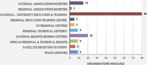
Throughout the continent today, real-time EO infrastructure is slowly emerging based on African priorities, brain attraction rather than brain drain, and African industry development. Across Africa, there are more than 90 institutions (universities/colleges/African and United Nations regional training centers) in 28 countries are engaged in remote sensing and Geo-information Sciences; over 53 national space agencies (sometimes referred to as the national remote sensing agencies), satellite receiving and tracking stations and regional technical laboratories (). Moreover, there are around 17 scientific National Associations or Societies and a Pan-African Association such as the African Association of Remote Sensing of the Environment (AARSE) [https://africanremotesensing.org/] with specialized expertise in EO and Geo-Information Science technologies.
Figure 1. The number of national and regional organizations, including space agencies and facilities currently involved in remote sensing and Geo-Information Sciences in Africa.
3.2 Academic institutions
Harnessing the power of the academic institutions to reduce poverty is not an ideological aspiration; it is an empirically demonstrable fact. After all, the only sustainable institutions in Africa are the universities; they are the national pride of every country, having withstood all upheavals in the continent. Applied research is one of the core businesses of universities everywhere.
Institutes of higher learning, such as universities and colleges, bring together many of the elements needed for innovative partnerships. The growing need to build human and organizational capacity, to address issues of environment and development offers universities, ample new opportunities to expand their teaching and research (National Research Council Citation2002).
Efforts to build capacities for managing EO/RS and geo-information in Africa span more than three decades. Traditionally, much of the capacity building had been by way of training a few professionals, mainly from the surveyor-general departments, and equipping these organizations in map-making and related activities. While success was booked in a few of these initiatives in terms of their objectives, most of them remained project-focused. They did not address long-term integrated development information needs. The shift in thinking regarding the environment and sustainable development in the 1980s triggered a huge demand for environmental information (United Nations, Economic and Social Council, Economic Commission for Africa, Citation2011). The United Nations system, led by the United Nations Institute for Training and Research (UNITAR) and UNEP, responded to this need to expand the capacity base in geographic information development and application to the management of the environment (United Nations, Economic Commission for Africa Citation2017). This action resulted in environment movement in the 1980s that put considerable pressure on governments to take steps for the effective management of the environment.
While universities serve as engine rooms at the national level/regional, remote sensing centers, including United Nations (UN) affiliated centers (Agbaje Citation2017) have been the main artery in transferring knowledge on satellite remote sensing and GIS in Africa. For example, AFRIGIST, Ile-Ife, Nigeria, and the RCMRD, Nairobi, Kenya have for over 45 years, played a critical role in the training and sensitization of remote sensing technology and GIS sciences, including consultancy activities. From 1973–2018, AFRIGIST alone has trained over 3500 trainees from 28 member countries (Akingbade Citation2018), AFRIGIST offers MSc courses to both the Anglophone and Francophone countries of West Africa. On average, from the year 2000 to 2008, the number of people trained at RCMRD in EO/RS and GIS was around 1200 trainee/year. In 2008, this increased to 2000, and currently, it has gone up to 3000/year for corporate/professional training and about 2500 for academic (certificate/diploma) (personal communication with Mr Byron A.O Anangwe, RCMRD).
Data and service providers such as NASA, ESA, JICA, GDTA (France), UN-ECA, UNEP, UN-SPIDER, USAID, the African Regional Center for Space Science and Technology Education (ARCSSTE) including universities in Europe and the United States has actively participated in education and training in Africa. In house education and training that went in partnership with institutions such as, the International Institute for Geoinformation Sciences and Earth Observation (ITC), The Netherlands (currently, a Faculty of the University of Twente) and other partners from Europe, North America and Japan cannot be underestimated. In particular, the ITC educated and trained more than 5000 students from 45 countries of Africa in Postgraduate, MSc and PhD degrees (Beerens Citation2002). The ongoing two weeks refresher course subsidized by the Netherlands University Foundation for International Cooperation (NUFFIC) have tremendously assisted in the development of highly qualified experts in photogrammetry, remote sensing and geo-information sciences in the continent.
In addition, organizations such as AARSE, the International Society of Photogrammetry and Remote Sensing (ISPRS), the IEEE Geoscience and Remote Sensing Society (GRSS), AfriGEOSS, and several other institutions from Europe, US and Asia have helped to increase manpower resources in the region and strengthened institutional in the field of geoinformatics and GIS through capacity building, technology transfer, international cooperation and the provision of internal African resources (Sumari et al. Citation2019). Organizations such as the ISPRS and IEEE-GRSS and donors have always been instrumental in organizing short three-day courses in various parts of Africa concurrent with AARSE Conferences. Some of these workshops cover topics on the introduction of Remote Sensing for Educators (dedicated to high school students), introduction to Remote Sensing for Local Authorities, application of remote sensing in geological mapping, environmental hazard mapping and risk analysis, spectrometry and spatial analysis and scientific writing Workshops
Sub-Saharan Africa is the most vulnerable continent to all types of disasters. The frequency of occurrence of geological and environmental hazards and disasters in Africa is increasing; and the social, economic, and ecological damage emanating from them is enormous. The United Nations University, UNU, through the International Institute for Geoinformation Science and Earth Observation, ITC, initiated a capacity development programme, culminating into the University Network for Disaster Risk Reduction in Africa (UNEDRA) (Woldai, van Westen, and Yazidhi Citation2006). Comprised of 15 universities in Africa, the principal objective of the network is to forge interaction amongst universities in the continent with interest on “education, training and research on disaster risk reduction, through capacity building, information sharing and collaborative research” (idem). The Network organizes disaster-risk related workshops at every AARSE Conference; the last in 2016 in Uganda, supported by the United Nations Development Programme (UNDP) to raise awareness about the benefits, products and services offered by earth observation and geo-information technologies to universities. Its main objectives are to (i) promote the advantages and applications of remote sensing and GIS for African economic development, (ii) improve the teaching of these technologies at African universities by providing better case studies, teaching materials and helping teachers improve their syllabuses.
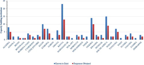
African Universities contribute to societal capacity by functioning as nodes in a global network of knowledge. Although the 2016–2019 survey is still ongoing, the preliminary result so far reached, identified 90 national institutions representing 28 African countries. These institutions () consisting of universities/colleges and national/regional centers are believed to provide dedicated geomantic, remote sensing and geoinformation science education and training on the continent. While 11% of the universities and colleges are known to offer three to seven day GIS courses in their undergraduate curriculum; around 23% have degree and research programs leading to BSc, MSc, and PhDs. A few of the prominent universities offering degrees are shown in .
Table 1. Some of the prominent university departments offering degree courses in Africa. Included into the list are also space agencies partnering with universities in research programs.
EO/RS and Geo-Information technologies and space science have an indispensable role to play in achieving the United Nations Sustainable Development Goals through the measurement and management of resources. Most of the African universities, however, are ill-equipped and lack the capacity for increased earth observation activities (Nakweya Citation2018). Kufoniyi (Citation2006) reiterated that many of the African EO/RS and GIS specialists working at universities, like their counterparts in other developing countries, suffer from obsolete curricula and facilities, continued use of outdated production techniques. They also lack advanced computers and software facilities, financial resources for overseas training, have uniform academic standards, and lack networking and adequate enabling technologies. A 2018 conference (Nakweya Citation2018) brought together over 400 academics, applications and software developers, hardware manufacturers, geospatial data producers and vendors, researchers, and policymakers representing 20 RCMRD’s member states drew the same conclusions as outlined by Kufoniy (Citation2006), that African universities suffer from inadequate instructors, a lack of investment by the authorities and lack the capacity for increased EO activities. According to Simon Onywere, the director of research dissemination and uptake at Kenyatta University, Kenya there is “a need to persuade universities to increase financial allocations to space science courses and to localise content” (idem). The current situation is that many universities are offering courses in EO/RS and Geo-Information Sciences, which is commendable. A report from the International Service for National Agricultural Research (ISNAR) emphasized that “in an increasingly competitive world, universities cannot afford to be seen as purely academic institutions only; they are also expected to organize their considerable human and material resources to contribute materially to national research and development objectives” (Michelsen et al. Citation2003)
Figure 2. Survey questionnaire results on academic institutions (Universities/colleges) offering courses in EO and Geo-Information Sciences. Three persons/country, identified from the 2016 private sector companies list of respondents, were used in this survey questionnaire.
3.3 African space agencies
In the last few years, the technological advancement in Africa has been slowly gaining pace to supply the needs for high and medium resolution imagery from an entirely African technology base. To date, 36 satellites were already launched into orbit by 11 African countries, namely, Algeria, Angola, Egypt, Ethiopia, Ghana, Kenya, Morocco, Nigeria, Rwanda, South Africa (Alemayehu Adde Citation2019; Space in Africa Citation2019a) and Sudan (). In addition, five satellites are currently built to replace failed satellites or have extended their launch date. These include the Angolan AngoSat-2 (built to replace AngoSat-1); the Egyptian nanosatellites NileSat-301 (built to replace NileSat-201), NExSat-1 (planned to be launched in 2019 but delayed) and NARSSCube-2 (identical to NARSSCube-1 in preparation) and the South African nanosatellite XinaBox ThinSat (planned to launch in 2019 but now extended to 2020). By the beginning of 2021, therefore, the total number of satellites deployed by 11 African countries will amount to 41 satellites.
Table 2. The list of African satellites launched from 1998 to 2020. The satellites were launched for Earth Observation (Designated as A); science technology demonstration and education/scientific experiments (B); Communication (C); Reconnaissance/Military (radar) (D) and for climate change and weather monitoring (E).
Of the 36 satellites already launched, around 12 are nanosatellites (TubeSats, and CubeSats) launched for science technology demonstrations, scientific experiments, and educational projects. Eight are in the area of communication, four in reconnaissance/military radar and two for climate change and weather monitoring. The rest are in the areas of earth observation ().
Institutions from four countries, the Agence Spatial Algerienne (ASAL), National Authority for Remote Sensing and Space Sciences (NARSS), National Space Research and Development Agency (NASRDA) and South African National Space Agency (SANSA) have space engineering capabilities and are at the forefront of these space missions. Moreover, South African involvement in space-related activities dates back to the late 1950s when South Africa demonstrated its capability with in-house built micro-satellites (GREENSAT and SUNSAT). Since 2003, the country has launched seven satellites, which include the most publicized Sumbandilla satellite built at Stellenbosch University. The latter University offers an excellent MSc and PhD course in Satellite engineering. The University in the last 12 years has become a hub for African engineers and scientists who want to study space engineering. The third cube satellite, known as TshepisoSat (Code name ZACUBE1, 2013), for example, was developed by a high school student, in the Eastern Cape province of South Africa. It was South Africa’s first cube satellite.
The Kondor-E satellite is a small S-band Synthetic Aperture Radar (SAR) that can operate both continuous swath surveys and detailed spot surveys. The satellite covers a swath width of 10 km and has a ground resolution of 1–2 m in spotlight mode, 1–3 m in strip-map mode and 5–30 m in ScanSAR mode (Gunter’s Space Page (n.d.). The three nanosatellites, namely: nSight-1, ZA-AeroSat, and the ZACUBE-2 were designed and manufactured the Cape Town Group SCS sp, CubeSpace of Stellenbosch University and by the post-graduate students at the Cape Peninsula of Technology, French South African Institute of Technology. Both the nSight-1 and ZA-AeroSat satellites are equipped with an s-band SAR. Another mini-satellite XinaBox Thinsat built by South African High School Students as part of the ThinSat program designed to attract student (from middle school to the university level) participation in the space industry through foundational space and STEM programs that will most probably be launched in 2020.
Algeria is prone to natural disasters such as locust invasion, forest fires, floods, earthquakes, landslides, and movement of dunes. There is also a dire need for cartographic revision, cadastre, land use planning, natural resources, urban and infrastructural mapping. Hence, the main objectives of the Algerian space program are to respond to national needs and concerns in terms of space applications and disaster management. From 2002 to 2017, the country, through its space agency, Agence Spatiale Algerienne (ASAL), has launched six satellites in the areas of earth observation (4), communication (1) and one nanosatellite for science technology demonstration and education. Alsat-1 launched in 2002, is the Algerian contribution to the broader international collaboration designed explicitly for the Disaster Monitoring Constellation (DMC) project. It was designed and built by Surrey Space Technology, United Kingdom. AlSat-1, with an imaging swath of 600 km and a revisit period of four days, provides images having a 32-meters resolution in three spectral bands (NIR, red, green). As part of a technology transfer programme, 11 Algerian engineers were trained by Surrey Satellite Technology Ltd (SSTL) to equip the Agency with future manufacturing of its satellites. Alsat-1B is an Algerian medium resolution EO satellite hosting a 24 m multispectral imager and a 12 m panchromatic imager. It was built jointly by ASAL and SSTL.
The ALSAT-2 satellites (ALSAT-2A and ALSAT-2B) are similar in configuration and both are capable of supplying images with 10 meters in each four color band (B/G/R/NIR) when in multispectral mode and at high 2.5 m resolution in the panchromatic mode. The images obtained by both satellites are used in a wide variety of applications: cartography, management of agriculture, forestry, water, mineral and oil resources, crop protection, management of natural disasters and land use planning. ALSAT-1N is a nano-satellite launched on 26 September 2016, by the Algerian Space Agency ASAL and the UK Space Agency to be used as a cost-effective demonstration of space technologies education to Algerian students. ALCOMSAT-1, representing the first Algerian communication satellite ( was launched on the 10th of December 2017. With its launch, the country has bolstered its hold in space telecommunication and successful broadcasting of public television and radio channels).
Egypt involvement in space science can go back to the early 1900s. Through its Helwan Institute of Astronomy and Geophysics (Ngcofe and Gottschalk Citation2013), Egypt shared in the discovery of the planet Pluto in the 1930s and has actively engaged in atmospheric aerosol studies in the 1980s (idem). Egypt launched its first EO satellite – EgyptSat-1 – in 2007. To date, it has successfully launched around seven satellites to orbit (See ); three Earth Observation and three communication satellites, including one nano-satellite NARSSCube-1; the latter for providing educational and training satellite to promote applied science research in space engineering in various Egyptian Universities and research institutes. The satellite is loaded with a small camera having a spatial resolution of 100 meters to take snapshots of Egyptian territories. (https://space.skyrocket.de/doc_sdat/narsscube-1.htm). NARSScube-2 (identical to NARSScube-1) is to be launched in 2012.
EgyptSat-1 is Egypt’s first remote sensing satellite launched on 17 April 2007. Two instruments: multispectral imagery (B: 0.50–0.59 µm; G: 0.61–0.68 µm; R: 0.79–0.89 µm; Pan.: 0.50–0.89 µm) with a spatial resolution of 7.8 m at nadir and a 39 m (cross-track) ×46 m (along-track) infrared imager (1.55–1.7 µm) was flown . The satellite failed in July 2010, three years after it was launched. The successor; Egypt’s second remote sensing Earth observation satellite, EgyptSat-2 was slated for launch in 2014. With a spatial resolution of 1 m (in panchromatic mode) and 4 m (in multispectral mode), the satellite camera can take both single-frame and stereoscopic images and can operate in push-broom continuous imaging or cartographic mode. In April 2015, after only a year in orbit, the EgyptSat-2 became unresponsive to the ground command post and control over the satellite was lost for good. The EgyptSat-A is an improved version built-in 2019 to replace EgyptSat-2. It is the third earth remote sensing satellite built jointly by NARSS with RKK Energiya in Russia and comprises of 4 m. resolution multispectral imagery and a 1 m panchromatic imagery. The NARSS plan calls for a new EO satellite called “NExSat 1” jointly developed with the Berlin Space Technologies (BST). This micro-satellite is an experimental satellite that will enable NARSS to fly and test new technologies.
Egyptian communication satellites date back to NILESAT-101, launched in 1998 subsequently followed by NILESAT-102 launched in 2000 and retired in June 2018, and the NILESAT-201. The latter satellite carries four transponders in the Ka-band and 24 Ku-band transponders for direct-to-home television, including radio and data-transmissions to the Middle East and North Africa.
Nigeria established the National Space Research and Development Agency (NASRDA) in April 1999. Since then, it has launched five EO satellites; three low (640 × 560 km) and high (2.5-m panchromatic, 5-m and 32-m multispectral) resolution EO satellites and two communication satellites, of which its 2007 NIGCOMSAT-1 failed in orbit after running out of power. It was replaced by NIGCOMSAT 1R in 2011. The latter is currently providing broadcast and internet services in Nigeria.
NigeriaSat-1, NigeriaSat-2, and NigeriaSat-X are earth observation satellites. NigeriaSat-1, for example, is the Nigerian contribution to the international Disaster Monitoring Constellation (DMC) project. The DMC consortium, forms the first-ever microsatellite constellation bringing EO capabilities both nationally to the individual satellite owners, and internationally to benefit worldwide humanitarian aid efforts. Nigeria’s satellites support food production in the region and disaster relief around the world (Aron Citation2013). A Nigerian satellite was the first to track and send back pictures of the east coast of the US following Hurricane Katrina (idem). They also contributed images to aid workers following the 2004 Indian Ocean tsunami. NigeriaSat-2 and NigeriaSat-X both succeeded NigeriaSat-1 in 2011 carrying similar instruments. NigeriaSat 1 and 2 were built by the Surrey Satellite Technology Ltd (SSTL). Over the last one and a half years, the Nigerian satellites have monitored the movement of terror group Boko Haram in the northeast of the country. NigeriaSat X, is a small training satellite built by a team of 25 Nigerian trainee engineers at SSTL.
In the last two years alone, Angola, Ghana, Kenya, Morocco, Rwanda, Sudan and Ethiopia have joined the race (). Most of them have launched low-cost Nano-satellites into orbit. The satellites launched are in the area of communication, science technology and education, or monitoring crops and the weather. Angola’s first satellite AngoSat-1, for example, is a geostationary communication satellite (with C- and Ku-band transponders) built by the Russian Company RSC Energia, to deliver television, Internet, and radio services to Angola and other territories. It was launched on the 26 of December 2017. Communication with the satellite, however, was lost during solar panel deployment when the satellite was moving to its geostationary orbit; and was declared defunct by Russia four months later. AngoSat-2 is now built on no extra cost to replace AngoSat-1 by 2021.
Morocco bought two very high-resolution satellites from Thales/Airbus. Images from the powerful EO satellite have a resolution of 70 cm and can be taken from anywhere on the globe in less than 24 hours. Morocco is the first African nation to acquire such a powerful surveillance satellite (France24 Citation2017)). The satellites will also be used for mapping and land surveying activities, agricultural monitoring, regional development, natural disaster management, and change detection. Morocco-TUBSAT is an EO/RS and vegetation detection low-resolution satellite used for science education/training applications.
Ghana and Kenya had their nanosatellites project built in Japan and Italy. GhanaSat-1 is a small multi-disciplinary science education/technological CubeSat (1U) built by Kyushu Institute of Technology (Kyutech) as the Joint Global Multi-Nation Birds Satellite project (Russell Citation2017), a cross-border interdisciplinary satellite project for non-space faring countries, supported by Japan. In addition, Kenya’s 1KUNS-PF is a project for the development of nanosatellites for EO applications, built by a joint team of Italian and Kenyan university students focused on the target areas of East Africa and Italy. The satellite provides 10 images per day of an area of interest at a ground resolution of 150 m. It will be used for science technology and education.
On February 2019, working with a U.K.-based company OneWeb, Rwanda successfully launched its first satellite “Icyerekezo” that will bring internet connectivity to students in remote schools; thus bridging the digital divide. (Face2FaceAfrica Citation2019). A second Rwandan satellite, “RWASAT” was launched into low orbit on 20 November 2019. The CubeSat (3U), destined for space research, will collect data on water resources, natural disasters, agriculture, and meteorology (Ecofin Agency Citation2019). It was built by Rwandan engineers in collaboration with Japan International Cooperation Agency (JICA), the Japan Aerospace Exploration Agency (JAXA) and the University of Tokyo.
The small Sudanese remote sensing satellite, known as SRSS-1 was launched on 3 November 2019. It was developed and designed for both civilian and military remote sensing purpose by the Shenzhen Aerospace Oriental Red Sea Satellite Co (Space in Africa Citation2019b). Its main objectives are to generate a reliable database on topographical mapping, natural resources and environmental hazard monitoring, crop yield estimation. Another purpose is to use space technology for public security (intelligence gathering) and military applications.
20 December 2019, highlights the launching of Ethiopia’s first micro-satellite (ETRSS-1) from a space station in China. The 70 kg satellite – a weather monitoring spacecraft, will transmit datasets back that will assist in evaluating the environment and weather patterns in the Horn of Africa. The EO data received will also be used for monitoring water, agriculture, climate change, the environment, and mining.
In addition to the 41 national satellites as described, African institutions jointly funded three other communication satellite projects – RASCOM-QAF1, RASCOM-QAF1R, and New Dawn (Space in Africa Citation2019a), for regional operations bringing the total number of satellites (launched or planned) to 44. Four countries, Tunesia, the Democratic Republic of Congo (DRC), Senegal, and Tanzania, have emerging space programs or are interested in developing one.
In response to this sudden surge and trend in space activities, the African Union (AU) proposed the creation of an African Space Agency (AfriSpace) in 2015 and plans to launch it by 2023 with a new proposed headquarter in the suburb of New Cairo, Egypt, to be funded by the Egyptian Government (Egypt Today Citation2019).
The number of African countries having satellite receiving and tracking stations has also increased in the last ten years. Currently, ten stations are known to exist in six African countries. Algeria, Egypt, Kenya, and South Africa each have two receiving and tracking stations for satellites, and Gabon and Nigeria each have one receiving station.
3.4 Private sector
The creation of new companies over the last 20 years and their development clearly shows that the African private sector is slowly picking up. The incorporation of new companies has been active in the last 15 years.
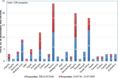
The 2016 two months long, Africa-wide survey questionnaire conducted using Survey Monkey; included 78 companies (60 English and 18 French-speaking) out of a total of 229 identified, representing 21 African countries. The summary report of the 2016 survey findings is available in: (SatMagazine Citation2016; Woldai and Zeil Citation2016).
Encouraged by the moderate success booked in 2016, the survey questionnaire, on Survey Monkey website, was left open until May 2019. From 2016–2019, a total of 46 new companies () from 16 English (Angola and Mozambique included) and nine from French-speaking countries were registered. This raises the responding private sector companies involved in EO and Geo-Information Sciences in Africa from 78 to 130; a 49% increase thus from 2016.
Figure 3. Added number of African private companies registered by 2019. Most of them are late respondents to the call made in 2016.
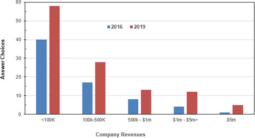
Around 98% of the companies, including the new ones, are privately owned African SMEs. In comparison to the 2016 Survey, the sector has grown in terms of both employment () and revenues () in the last two years with optimistic prospects for the near future. The number of people employed by 2019 increased almost by 66% from 2719 in 2016 to 4109. In terms of revenues, 26% of all companies, amounting to 116 respondents in 2019, performed in a range from $500k – $ 5 million compared to 19% in 2016. Around 7% of companies in 2016 had revenues in the range of $1 m – $ 5m or above while in 2019 this has doubled. Some companies from Ethiopia, Ghana, Kenya, Nigeria, and South Africa, have taken the opportunity created since the 2016 report to open subsidiary companies in the East and West African countries.
Figure 4. The total number of employees accounted for 2019 (red) versus 2016 (blue). The late respondents registered more than 45% increase in employees to the 2016 calls.
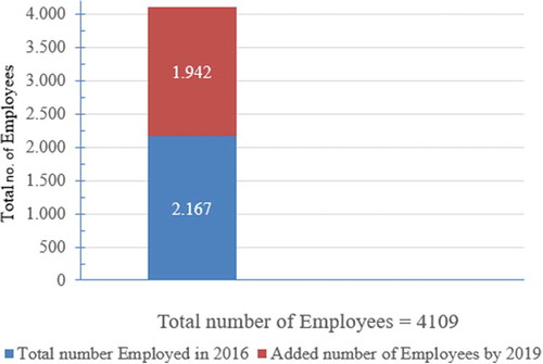
Figure 5. Company revenues increased in 2019.
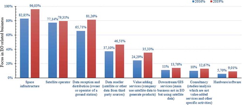
Added to the 2016 survey, most of the private companies are active on the national level (79%) and provide downstream/GIS services (92%), consultancy (79%?) and value-adding services using satellite data to create products (80%). The three most important market segments in which companies do business are local and regional planning (66%); Environmental monitoring, pollution, climate (59%); Agriculture (51%), geology and mining 12% (). The main clients of respondent companies are the public sector (53%) but also private companies (34%). As in 2016, in terms of governmental and private sector support, the three most significant obstacles to growth are a lack of development funding; a lack of venture capital; and unfavorable policy and legal provisions.
Figure 6. This figure shows the most important market segments in which companies do business.
The survey on the African private industry conducted in 2016 was the first of its kind in the continent. The updated survey of 2019 ascertained around 4110 people working in 130/229 companies identified within 28 out of the 54 countries in Africa. There are 26 countries where information on space-based activities and application is lacking. At the same time; there are more companies providing services in GIS and affiliated with ESRI (Citation2009) that were not included in the African private sector survey of 2016 or 2019. Another group of companies not earmarked in the last survey were: the data providers, data processors and analysts, trainers, technicians, data and information users, space-related media groups and advocates. Furthermore, there are several companies specialized in geology and mining, agriculture, forestry, biodiversity, urban planning that make use of EO and Geo-Information Sciences. Also, many ministry departments and universities have affiliated consultancy bureaus or companies with experts offering services to national agencies as well as neighboring countries. African companies are collaborating with international companies, NGO, universities, private companies, and foreign governments including space and aid agencies that currently constitute a significant source of geographic data, information, training, and support. Not all these companies were targeted in the 2016 or 2019 surveys. Ongoing investigation on this issue by the author reiterates that the companies dealing with space-based datasets and Geo-Information Sciences plus the private spin-off companies created because of the African space industry are believed to absorb at least more than 15,000 people today and the assumption is going to exceed 100,000 by the year 2025.
4. Conclusion
The African continent, with over a billion people, has been one of the rapidly growing economies in the world. It is no wonder, therefore, that the continent is awakening to look into space-based EO and Geo-Information Sciences technologies and investment to proliferate, harness and use the benefits that this technology offers. According to the African space industry Annual Report for 2019 (Space in Africa Citation2019a), the African space market now generates over USD 7 billion annually, and this is likely to exceed USD 10 billion by 2024. The sudden increase in the deployment of satellites by the African States might appear irrational to some; especially that the continent has more pressing issues such as poverty, food shortage, deforestation, scarcity of water, energy and many of the natural and environmental disasters affecting the livelihood of its population (Weir Citation2018). Many of these issues are daily news affecting the continent and its people. These problems, however, can be tackled using space-based EO and Geospatial techniques to a certain extent.
4.1 The trend
More than ever, space-based information will undoubtedly be used in agriculture and mining; by far the most important economic sector in much of Africa. It will also play a significant role in risk reduction and disaster management, profoundly affected by natural and human-made disasters. Space-based information can also be used widely for monitoring climate-related changes, desertification, flood hazards, and soil erosion, as well as in risk assessment, groundwater exploration and transportation services. Using spaced-based data saves time and costs to acquire valuable information otherwise difficult to obtain by conventional field mapping techniques alone. In short, space is not just about prestige; it is a recognized fact that space is an essential tool for decision making and a useful tool for leapfrogging African development.
African countries will look to space as their new challenge and country after country in the coming years; will lineup to launch satellites into orbit. Unlike the pre-2011 hype, an encouraging sign today is that most of the countries outlooks on launching a satellite have changed tremendously. In the first instance, most of the satellites are built by trained African engineers in partnership with foreign countries, and secondly, the satellites are built and launched to solve burning problems in the countries concerned. The advantages coming from space activities is slowly trickling down the value chain,
There are more than 53 national space agencies (also known as the national remote sensing agencies) and regional technical laboratories. There are around 17 scientific national/Pan-African Associations and Societies and a total of 90 national education and training institutes (e.g. universities, colleges, and national, and regional centers) offering degree programs, diplomas, and certificates.
In terms of employment and revenue, the spin-off from the space agencies is already showing its mark. Especially in those countries which have launched more than three satellites to date (e.g. Algeria, Egypt, Nigeria, and South Africa), the investment by the countries involved in space engineering, EO and Geo-Information Sciences and geomantic education and research including the creation of the national space agencies and private companies have increased tremendously.
4.2 The challenge
While the trend in space development in Africa is currently running in high gear, there are more steps for Africa to climb, and the challenges are too much:
If Africa is to leapfrog effectively, the continent needs to develop an indigenous critical mass of trained space scientists and engineers. The continent must build its capabilities in EO, satellite communication, satellite systems, navigation and positioning, and space sciences. Universities and colleges are repositories and generators of knowledge. Unfortunately, most African universities have an outdated curriculum and are also poorly funded and equipped to participate in any of the space-based activities.
If governments can put more than 10 million USD into launching a satellite into orbit, they should be able to spend more money into universities that teach science and math, including advance processing of earth processes. Digital processing of images, constitute the most lucrative ground segment of the space industry; that is, jobs on the ground, not in orbit (Gottschalk Citation2017).
For many years, Africa has suffered unbearable instability, poverty, death, and destruction. Since 2013 however, the economic growth of the continent has been tremendous; Africa now houses seven of the world’s fastest-growing economies. How long this economic development continues is anybody’s guess. Participating in space activities demands capital, for most African countries, that a limited commodity that cannot be sustained.
Inadequate enabling technologies: i.e. poor ICT infrastructure; Communication and internet connectivity is another barrier to development.
Currently, few African scientists make use of EO data originating from their own country’s satellite. The 2019 survey of the Africa private sector industry demonstrates that African satellite data currently does not play a substantial role in the private business. As it turned out in answers to an additional specific question on African Satellites, namely the NIGERIASAT Family, ALSAT Family, EGYPTSAT Family and SumbandilaSat, the results reached reveals that most company respondents do know these data suppliers (78%). However, 22% of the respondents, (that is 32 out of 130 respondent companies from the 2019 survey) are not fully aware that some African nations have their mini-satellites.
Except for South Africa, in those countries known to have launched satellites in the last six years, researchers, educators and private companies complain of having no access to space-derived EO datasets. University researchers reiterate that they would like to acquire data coming from their country’s satellites. Unfortunately, the bureaucracy to obtain EO data is so restrictive that they prefer to download Sentinel or Landsat data instead. The availability and accessibility of free data are regarded by many of these groups as the most critical factor that could strengthen research and businesses in the sector. In terms of governmental and private sector support, the most severe factors hampering growth in the private sector are seen in unfavorable policy and legal provisions, lack of development funding and lack of venture capital.
Sharing of datasets between space agencies does not exist. It is the only way to stimulate partnership between various African countries.
Lack of cooperation and networking among relevant departments, even in the same institution:
During their 26th Ordinary Session on 31 January 2016 in Addis Ababa, the African Union Heads of State and Government adopted the African Space Policy and Strategy as the first of the concrete steps to realize an African Outer space Programme, as one of the flagship programmes of the AU Agenda 2063 (African Union Citation2016). This paper dealt with only one of the key priority areas of the African Space Policy – to develop a homegrown and sustainable space industry that promotes and responds to the needs of the African continent.
Acknowledgments
The current work would not have been successful without the support of many people and organisations, universities, colleges and regional centres who in one way or other contributed to this paper by making their programmes available. In this context, my special thanks go to my long friend Mr Andre Nonguierma (UN-ECA) for providing documents and self-contained database on education and training including the private sector companies in Africa. My highest appreciation also goes to Prof. Saidu Muhammad Gusau, former Director of the Nigerian Space Agency for providing me with information on his Agency. Again my highest regards go to my friend Mr Patrice Sanu, Director of the Centre Universitaire Siget-A Sig et telédétéction Adjaratou, Burkina Faso for his dedication and for the list of universities and west African private Sector companies involved in EO/RS and Ge-Information Sciences. A particular word of appreciation and thanks goes to Dr Byron Anangwe for providing me with valuable information and database regarding the RCMRD and other relevant public and private sector companies; including names and affiliations of universities/colleges and regional/national centres in Kenya and the surrounding countries; for Prof Sias Mostert for providing resources and advice when it comes to Space Agencies. It is highly appreciated.
I would also like to take this opportunity to thank the many people I have contacted by phone to validate the information I have. All the companies that have spent their time responding to the 2019 survey questionnaires are highly appreciated. I also would like to acknowledge the support and feedback received from my colleagues in AARSE, such as Mr.Mahamadou Keita, the former Deputy Director of RECTAS and Vice President of AARSE for West Africa; Dr Yazidhi Bamutaze from Makerere University and the current Vice President of AARSE for East Africa; Mr Souleye Wade, the current Communication Manager of AARSE; Prof. Islam Abu El-Magd, the current Vice President for North Africa for providing pieces of information on education and private sector companies involved in remote sensing and geo-information sciences within their sphere of influence. Special thanks go to my colleagues and long-time friend, Prof. Olajide Kufoniyi, the past President of AARSE for his unflinching support and encouragement during the preparation of the African private sector companies survey. Lastly, I salute my friend Mr Peter Zeil, the University of Salzburg and a member of the Board of Trustees of AARSE, for his wise advice during the preparation of the first African private sector survey.
Most of the work on this paper is derived from my own experience during years of involvement as founder, and past president of the African Association of Remote Sensing of the Environment (AARSE), including representing the Association in many national and continental discussions on EO and Geo-Information sciences in Africa. Anything on academic institutions highlighted in the paper originates from years of work assignments with universities and colleges in 26 Africa countries. I was lucky enough to teach and conduct collaborative research in many of these universities and to see the weaknesses and strengths of the university closely as a staff member at the International Institute for Geo-Information Science and Earth Observation (ITC), the Netherlands. To the many who responded to my request to fill the survey questionnaires, I am grateful.
The author is very thankful to the funds received from the European Commission (Directorate-General for Internal Market, Industry, Entrepreneurship and SMEs - DG GROW) during the 2016 African survey of the private sector industries. I want to extend also my sincere thanks to Dr Geoff Sawyer (Executive Director of ERSEC) and Dr Stéphane OUREVITCH, Partner, Head of the Brussels Office, SpaceTec Partners SPRL for their support and comments of the 2016 survey. Finally, highest regard and appreciation goes to Dr Elisabeth Zeil-Fahlbusch (AARSE’s past Communication Manager) for her untiring dedication, excellent work and sharp comments when we conducted the African Private Sector survey in 2016.
Additional information
Notes on contributors
Tsehaie Woldai
Tsehaie Woldai has worked for many years at the Faculty of Geo-Information Science and Earth Observation (ITC). Currently, he is a Visiting Professor of Geological Remote Sensing at the School of Geosciences, University of the Witwatersrand, Johannesburg, South Africa and a Visiting Professor of remote sensing at the State Key Laboratory of Information Engineering in Surveying, Mapping and Remote Sensing (LIESMARS), Wuhan University, China. Woldai is the Founder and Past President of the African Association of Remote Sensing of the Environment (AARSE), Coordinator of the University Network for Disaster Risk Reduction in Africa (UNEDRA), a fellow of the African Acadamy of Sciences, a Fellow of the African Geological Society, and a winner of over 20 prestigious awards; involved in many ISPRS Commissions and Working Group (as Chairman/Vice Chairman/Secretary); engaged in over 40 national/international Advisory Programmes and over 20 international research as Principle or co-investigator.
References
- African Association of Remote Sensing of the Environment (AARSE). n.d. Accessed 21 January 2020. https://africanremotesensing.org/
- African Union. 2016. “African Union Heads of State and Government Adopts the African Space Policy and Strategy.” Accessed March 2016. https://au.int/en/pressreleases/20160131-3
- African Union. n.d. “Food Security.” Accessed 30 November 2019. https://au.int/en/auc/priorities/food-security
- Agbaje, G. I. 2017. “United Nations Regional Centre for Space Science and Technology Education in Africa: Achievements, Opportunities, Challenges, and the Future.” Environment and Ecology Research 5 (5): 386–394. doi:10.13189/eer.2017.050508.
- Akingbade, A. O. 2018. “AFRIGIST: Background, Relevance and Impact.” Fifth meeting of the Working Group on Geospatial Information of the IAEG-SDGs, Nairobi, Kenya, December 5–8. http://ggim.un.org/meetings/2018-WG-IAEG-SDG/documents/06_5th_WG_GI_IAEG-SDGS_AFRIGIST.pdf
- Alemayehu Adde, Y. 2019. “Socioeconomic Benefits of Space Technology for Africa.” IEEE-SEM 10 (6): 258–261.
- Aron, J. 2013. “How Nigeria Has Been Using Its Satellites”, NewScientists. Accessed 20 June 2019. https://www.newscientist.com/article/dn24025-how-nigeria-has-been-using-its-satellites/
- Beerens, S. J. J. 2002. “Capacity Building for Geospatial Information Handling in Africa: The ITC Perspective.” Presentation to Committee on the “Geographic Foundation for Agenda 21, Washington, D.C., January.
- Bovée, M. 2017. “African Nations over the Moon.”
- Ecofin Agency. 2019. “Rwanda Ready to Launch Another Satellite into Orbit.” https://www.ecofinagency.com/telecom/1705-40069-rwanda-ready-to-launch-another-satellite-into-orbit
- Egypt Today. 2019. “Egypt Allocates 10mn to Establish African Space Agency.” MENA, February 23. https://www.egypttoday.com/Article/1/65133/Egypt-allocates-10-mn-to-establish-African-Space-Agency
- ESRI. 2009. “Global Dialogues: GIScience and Sustainable Development in Africa.” A Column by Doug Richardson in GIS Best Practices, GIS in Africa. Accessed 16 June 2019. https://www.esri.com/~/media/Files/Pdfs/library/bestpractices/gis-in-africa.pdf
- EU Projects with African Union (AU). 2016. “Monitoring for Environment and Security in Africa (MESA) and Global Monitoring of Environment & Security (GMES).” May 11. Accessed 26 December 2019. https://eeas.europa.eu/delegations/african-union-au_en/867/EU%20Projects%20with%20African%20Union%20
- Face2FaceAfrica. 2019. “Rwanda Launches First-ever Satellite to Connect Remote Schools to the Internet”. Accessed 15 December 2019. https://face2faceafrica.com/article/rwanda-launches-first-ever-satellite-to-connect-remote-schools-to-the-internet
- France24. 2017. “Morocco’s Secret Launch of a Powerful Observation Satellite Puts Neighbouring Countries on Alert.” Accessed 11 June 2019. https://www.france24.com/en/20171120-morocco-secret-launch-powerful-observation-satellite-puts-neighbouring-countries-alert
- Gottschalk, K. 2017. “Here’s How Satellites Have Changed the Modern World.” World Economic Forum. Accessed 15 August 2019. https://www.weforum.org/agenda/2017/10/heres-how-satellites-have-changed-the-modern-world
- Group on Earth Observations (GEO). n.d. “AfriGEO: The African Group on Earth Observations.” Accessed 11 November 2019. https://www.earthobservations.org/afrigeo.php
- Kufoniyi, O. 2006. “Improving Capacity Building in Earth Observation and Geo-Information Science in Africa through Educational Networking.” IAPRS Vol. XXXVI, Part 6, Tokyo, 289–294.
- Larsen, A. M. E., and N. Davis 2019. “How Satellites Can Solve Africa’s Eco-challenges, from Deforestation to Illegal Mining”. Accessed 31 December 2019. https://www.weforum.org/agenda/2019/09/digital-earth-africa-illegal-mining-deforestation/
- Michelsen, H., L. Zuidema, C. Hoste, and D. Shapiro. 2003. “Reviewing and Changing University Contributions to Development-Oriented Agricultural Research in Sub-Saharan Africa.” ISNAR Briefing Paper, 59. The Hague, Netherlands: ISNAR.
- Nakweya, G. 2018. “Calls for More Investment in Geospatial Education.” University World News, Africa Edition. Accessed 05 June 2019. https://www.universityworldnews.com/post.php?story=20180906140421103
- NASA. n.d. “SERVIR-Eastern and Southern Africa: Challenging Drought, Famine and Epidemics From Space.” Accessed 10 October 2019. https://www.nasa.gov/mission_pages/servir/africa.html
- National Research Council. 2002. Down to Earth - Geographic Information for Sustainable Development in Africa: 8 Building Capacity to Apply Geographic Information to Sustainable Development in Africa. Washington, DC: National Academies Press. doi:10.17226/10455.
- Ngcofe, L., and K. Gottschalk. 2013. “The Growth of Space Science in African Countries for Earth Observation in the 21st Century.” South African Journal of Science 109 (1/2): 1–5. doi:10.1590/sajs.2013/a001.
- Rowland, J., E. Wood, and L. L. Tieszen. 2007. Review of Remote Sensing Needs and Applications in Africa, 124. US Geological Survey Earth Resources Observation and Science Centre, Sioux Falls, South Dakota.
- Russell, K. 2017. “New Entrants to Satellite in 2017 from Africa to Asia”, Via Satellite Podcast, December 5. https://www.satellitetoday.com/innovation/2017/12/05/six-new-entrants-satellite-industry-2017/
- SatMagazine. 2016. “The African EO & Geospatial Information Private Sector Survey.” http://www.satmagazine.com/story.php?number=960638589#
- SERVIR – West Africa. n.d. “Consortium Members.” Accessed 21 January 2020. https://servir.cilss.int/en/about/consortium-members/
- Space in Africa. 2019a. “‘Edition – Space’, African Space Industry Annual Report 2019.” Accessed August 2019. https://africanews.space/report/
- Space in Africa. 2019b. “Sudan Has Launched Its First Satellite; A Remote Sensing Satellite.” Accessed 05 November 2019. https://africanews.space/sudan-has-launched-its-first-satellite-a-remote-sensing-satellite/
- SpacewatchAfrica. 2018. “African Satellite Communications Yearbook 2018.” Accessed December 2018. http://spacewatchafrica.com/wp-content/uploads/2018/11/African-Satellite-Cimmunications-Yearbook-2018.pdf
- Sumari, N. S., S. Zhengfeng, J. L. Van Genderen, W. Musakwa, F. Ujoh, P. Washaya, and T. Gumbo. 2019. “Status of Geoinformatics Education and Training in Sub-Saharan Africa: Initiatives Taken and Challenges.” Journal of Geography in Higher Education 23 (2): 1–20.
- United Nations Economic and Social Council, Economic Commission for Africa. 2011. “A Guiding Framework for the Development of Capacity in Geospatial Information Management: The Case of Africa, Version 1, Global Geospatial Information Management (GGIM) Forum ((seoul, Republic of Korea)).” http://ggim.un.org/meetings/2011-1st_HLF-Korea/documents/W.P.7_Capacity%20Building%20Guiding%20Framework.pdf
- United Nations Economic Commission for Africa. 2017. “Geospatial Information for Sustainable Development in Africa, African Action Plan on Global Geospatial Information Management 2016-2030”. Accessed July 20, 2019. https://www.uneca.org/sites/default/files/PublicationFiles/un-ggim_-_geospatial_information_for_sustainable_development_in_africa-20171115.pdf
- Weir, A. 2018. “Africa’s Space Race-ready for Launch.” Asia by Africa When World collide. https://www.asiabyafrica.com/point-a-to-a/going-to-space-worth-the-cost
- Woldai, T. 2017. “Survey on the Health & Well-being of the African EO Companies.” (Proceedings), Earth Observation for Development and Adaptation to a Changing World, International Archives of the Photogrammetry, Remote Sensing and Spatial Information Sciences, Volume XLII-3/W2, 37th International Symposium on Remote Sensing of Environment (ISRSE 37), Tshwane, South Africa, May 8–12.
- Woldai, T., C. J. van Westen, and B. Yazidhi. 2006. “Building African Capacity for Disaster Risk Reduction through Networking, the Case of UNEDRA.” AARSE 2006: Proceeding of the 6th AARSE international conference on earth observation and geoinformation sciences in support of Africa’s development, Cairo, Egypt, 30 October - 2 November.
- Woldai, T., and E. Zeil. 2016. “Final Report - Inventory Africa EO Companies.” https://www.researchgate.net/publication/336348801_Final_report_-_Inventory_Africa_EO_companies
- Woldai, T., and K. T. Lance 2007. “Earth Observation in Africa: Home-grown, Cutting - Edge Space Applications Supporting Development.” Abstract and PowerPoint. Presented at the 2nd space and society conference space options for the 21st Century, ESA/ESTEC, Noordwijk, The Netherlands, 27 February - 1 March 2007. 1 p. And 24 slides.