
ABSTRACT
Since 2011 an intensive international cooperation has been in place between the Institute for Applied Photogrammetry and Geoinformatics (IAPG) at the Jade University of Applied Sciences in Oldenburg, Germany, and various Ukrainian universities. Following an initial contact by Prof. Gottfried Konecny, the first visit was organized, and was followed by many more. In subsequent years an intensive cooperation was established particularly with the National University for Construction and Architecture (KNUCA) in Kiev. In addition to architects and civil engineers, KNUCA also trains geodesists, geo-information scientists and landscape planners. The cooperation today includes the reciprocal exchange of scientists and students, research projects, courses and cooperation at many other levels. In addition, a commercial company has been established, SPM3D LLC, which now employs more than 14 engineers in the field of 3D acquisition, point cloud processing and modeling. This article summarizes the history of the cooperation and presents the results of associated student projects. In addition, results of joint work on the development of a virtual laser scanner are presented, part of a German-Ukrainian initiative to digitize teaching.
1. Introduction
1.1. General situation
Since the collapse of the Soviet Union, Ukraine’s recent history has been characterized by a democratically legitimate political system with free elections and a free press. Nevertheless, since the 1990s, an economic system has been developed in which oligarchs and corruption predominate, so that a small but powerful minority dominates politics and the economy. At the same time, there are still many Soviet-style structures in place, for example, in public administration, the health sector and education. The continuing dissatisfaction of the population with the situation in the country has led to various “revolutions”, such as the Orange Revolution in 2004 and 2005 and the protests on the Maidan in 2013. In the west of the country, in particular, strong leanings toward Europe can be observed. There are very close ties to Poland and other states of the former Eastern Bloc, and this is associated with a large migration of workers to neighboring European countries. Politically, economically and culturally, Ukraine is torn between Russia and Europe.
The Ukraine has a population of about 42 million, of which about 5 million live in Greater Kiev. The gross domestic product in 2018 was approx. 130 billion US$, i.e. only approx. 3100 US$ per inhabitant (Statistica Citation2020) (in comparison with Germany: approx. 41,000 US$ per inhabitant). Around 20%–25% of the total Ukrainian economic output is generated in Greater Kiev. However, the significant resources in minerals, agricultural land and education offer much greater potential. It is therefore of particular interest for Ukraine to move closer to the European Union and thereby achieve long-term economic growth and political stability.
Ukrainian higher education institutions in the fields of geodesy, photogrammetry and remote sensing played an important role in the former Soviet Union. Although most of the top-level universities were concentrated in Moscow, the Ukrainian universities in Kiev, Dnipro, Kharkiv and Lviv were acknowledged centers of excellence. Up to 70% of Soviet geodetic companies were run by Ukrainian graduates. Critically important aerospace companies are still located in the Ukraine.
Ukrainian universities participate with the EU in a variety of ways. For example, there have long been special funding programs such as TEMPUS, ERASMUS Plus, as well as special German-Ukrainian measures to increase international cooperation, aimed at reforming higher education structures and promoting teaching and research. Despite all this, the structures often remain outdated and characterized by a high degree of bureaucracy. Research and development suffer from poor financial resources, so that it is of particular interest here to contribute to further development through knowledge and technology transfer.
1.2. Personal background
The author studied geodesy at the University of Hanover from 1977 to 1983. During this time, he worked closely on topics relating to remote sensing and digital image processing in the context of student research projects. Here, lectures in photogrammetry were delivered by Prof. Konecny whose overseas academic commitments unfortunately prevented him from delivering a regular lecture timetable. Nevertheless, these attracted the author’s interest in photogrammetry which was strengthened in particular by Dr. Karsten Jacobsen via his exercises and seminars. Following his diploma, the author was able to take up a position as a research assistant, first in the Collaborative Research Center 149 in the field of remote sensing, then in close-range photogrammetry under the supervision of Prof. Wilfried Wester-Ebbinghaus. In 1988 he received his doctorate, which was examined by Konecny and Wester-Ebbinghaus. The work resulted in the development of a then unique scanning and comparator system based on the principle of reseau scanning invented by Wester-Ebbinghaus (Luhmann and Wester-Ebbinghaus Citation1988).
During subsequent employment in industrial measurement at the Swiss company Kern (Leica) in Aarau, Switzerland, he helped develop the innovative POM system (Programmable Optical Measuring System), one of the world’s first fully automatic photogrammetry systems for industrial metrology (Loser and Luhmann Citation1992). Subsequently, a professorship in photogrammetry and remote sensing was offered at the Jade University of Applied Sciences in Oldenburg. Throughout all this time, contact with Prof. Konecny and his Institute for Photogrammetry and Engineering Surveying (IPI) remained unbroken.
In 2011, Konecny facilitated the contact with Prof. Sergei Mogilny at the National Technical University in Donetsk, Ukraine. A first visit in that year led not only to Donetsk, but also to Kharkiv and Kiev. Since then, the author has visited Ukraine more than 30 times. Gottfried Konecny’s life work and his position as a role model has always been a strong motivation for promoting international exchange, overcoming cultural barriers, transferring technology and knowledge, and, to a certain extent, promoting international understanding.
2. Ukrainian partner universities
For the author, his first trip in 2011 to Eastern Europe provided new and surprising impressions of the university there, as well as of the city and its people. Donetsk is located in the southeast of Ukraine in the center of the Donbass, a well-known steel and coal mining region. The city had about 1.1 million inhabitants at that time. It only gained worldwide attention following the 2013 protests on the Maidan in Kiev. As a result, the Donbass region was separated from the rest of Ukraine. The ensuing war caused more than 10,000 deaths. The political future is still unresolved today.
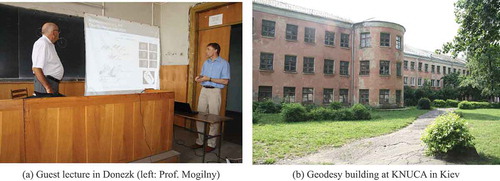
Geodesists are educated at the NTU, amongst others. One research focus is on engineering surveying by Prof. Mogilny, who had a long-standing relationship with Prof. Linkwitz from the University of Stuttgart. In addition to a guest lecture on close-range photogrammetry (), local excursions and discussions with colleagues took place. It soon became clear that although there are some thematic links in the field of photogrammetry, the greater interest lay in understanding how German universities cooperate with industry and what opportunities for additional funding arise from this. To this end, the typical structures and procedures at Jade University were explained. Cooperation with industry often begins with joint diploma, bachelor’s or master’s theses, which are completed at the locations of the relevant company or public authority. This model had not been customary anywhere at Ukrainian universities until then.
Figure 1. First visit to Ukraine
Further cooperation possibilities exist in Germany through publicly funded research projects, where cooperation with industry is absolutely essential. These also lead to a comprehensive bilateral transfer of knowledge and often to long-term partnerships. Although the Ukrainian state also offers various research programs, the financial resources are orders of magnitude smaller than in Germany.
In Kiev, this was followed by visits to KNUCA () and the Metrobud company which, among other tasks, carried out terrestrial laser scanning projects during the construction of the Kiev Metro and for the documentation of the Kiev Cave Monastery at Lavra (UNESCO World Heritage Site, see Shults, Bilous, and Kovtun Citation2019). At KNUCA, too, the poor condition of the university buildings and the extremely limited technical equipment were striking. Photogrammetric education continued for many years on outdated analog Soviet stereo plotters. Lack of computer equipment, no Wi-Fi and only limited Internet access were further characteristics of everyday university life.
The precarious financial situation at Ukrainian universities is also reflected in the fact that professors and staff have few opportunities to attend international conferences and congresses. In contrast, the number of professors, lecturers, scientific and technical staff is relatively high, although it is also noted that many professors continue to work after their official retirement.
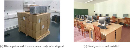
In 2014, the author succeeded in sending 18 decommissioned but fully functional computers from Oldenburg to Kiev and in providing KNUCA with a GIS laboratory free of charge (). In this way, computer facilities were considerably improved, especially for students.
Figure 2. Transport of computers to Ukraine for a new GIS lab
3. Student exchange
3.1. Outline
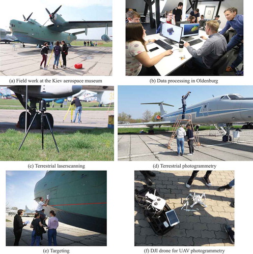
Since 2015 an annual student exchange project between Jade University and KNUCA has been organized. The aim is to work together on projects in the field of photogrammetry and laser scanning in groups comprising equal numbers of German and Ukrainian students. As part of this, one-week measurement campaigns take place in Kiev, where project planning and field measurements are carried out. Older total stations and laser scanners borrowed from local companies are usually available, but equipment from Oldenburg is also used. A few weeks later, the Ukrainian students make a return visit to Oldenburg to evaluate the recorded data on the powerful computers available there. In preparation, the author delivers a lecture on “Photogrammetry and Laser Scanning” in Kiev. Both modules are an integral part of the curriculum as regular courses (Kravchenko et al., Citation2016). The project is fully financed by the Jade University’s Fund for Internationalization.
Complex objects are recorded, e.g. monuments, memorials, buildings, and interiors. After the groups form and the teams get to know each other on the first day, an on-site inspection of the objects to be measured and the geodetic network planning for the acquisition of control points is carried out. Days 2 to 4 are followed by on-site measurements, consisting of targeting, tacheometric network measurement, terrestrial laser scanning and photogrammetric image acquisition. Depending on the object, UAV flights will also be carried out. Usually, the geodetic network adjustment, the registration of the laser scans and the first photogrammetric image evaluations (structure-from-motion) are completed during this time. On the final day, a joint presentation of the intermediate results takes place. summarizes some impressions from student work in Kiev and Oldenburg.
Figure 3. Impressions from the German-Ukrainian student exchange program
In the second project week in Oldenburg, the data are processed. In particular, this requires the calculation and registration of point clouds in a common coordinate system. Here it becomes clear very quickly whether object areas have been omitted on site, whether there are errors in the data and the different qualities which result from the different measurement technologies. Once the point clouds have been cleaned up and merged, the 3D modeling is carried out. The minimum goal is the derivation of a colored surface model (mesh) including a corresponding quality analysis. Some groups also manage to create more advanced results, e.g. drawings or models in AutoCAD. At the end of the second week of the project, the final presentations take place with the participation of other interested university members.
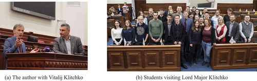
In addition to the technical and professional work, the project weeks also include local excursions, city tours and other activities organized by the students themselves. In 2019, there was a visit by the Lord Mayor of Kiev, Dr. Vitali Klitchko (), who showed considerable interest in the German-Ukrainian exchange, as well as in the technical results of the work and its potential use for the city of Kiev.
Figure 4. Visiting Lord major Vitalij Klitchko
The educational value of these projects is extremely high. Students must handle all communication in English, learn to use new equipment and software, create time and work schedules, deal with unforeseen problems and cope with a different professional and personal cultures. It is usually the first time in their studies that they have to solve a complex project task completely on their own, from the initial task description to the solution and final result.
3.2. Results
Each project group works on 1–2 projects. The workflow for the laser scanning projects is as follows:
Geodetic net adjustment (3D ground control points)
Registration of laser scans with transformation to ground control points (Leica Cyclone)
Checking and cleaning the point cloud (CloudCompare)
Meshing (CloudCompare, Geomagic)
Modeling (AutoCAD, ReCap)
For photogrammetric evaluations, Agisoft Photoscan or Metashape were the main software packages used. In some cases, iWitness was also applied. The work flow then looked as follows:
Alignment (Agisoft)
Dense point cloud (Agisoft)
Meshing (Agisoft)
Export
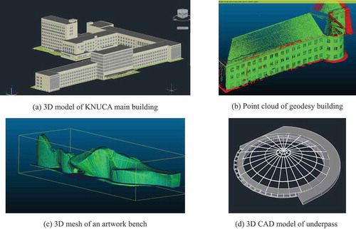
shows the finished 3D model of the KNUCA main building complex as a CAD model. The data were acquired in parallel with a Faro Focus scanner and a Leica C10 scanner. Since the C10 data had a considerably higher quality and also required fewer viewpoints, only this data was processed to completion. shows the point cloud representing the geodesy building (see ) in a color-coded comparison with the meshing result. shows the 3D model of an artwork bench which has a number of vertically arranged wooden elements, each separated by a gap of several centimeters. Finally, shows an example of another CAD model, here defining glass roof of a pedestrian underpass.
Figure 5. Examples of 3D models created in joint student projects
4. Professional work
4.1. Academic exchange
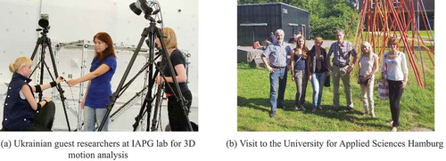
The second aspect of the German-Ukrainian cooperation concerns professional academic and technical cooperation. The primary aim here was to bring Ukrainian scientists to German universities in order to give them an up-to-date insight into teaching and research, and to support them in pushing ahead with university reforms in their own country. These activities were largely funded by the internationalization programs of the Ministry of Science and Culture of Lower Saxony, the German Academic Exchange Service (DAAD) and Jade University. As early as 2012, two staff members from Kiev, Ms. Julia Kravchenko and Ms. Tatiana Kvartych, were invited to Oldenburg for a guest stay of several weeks (). This included visits to the Hamburg University of Applied Sciences (Prof. Thomas Kersten, ) and the Leibniz University of Hannover (Prof. Christian Heipke).
Figure 6. Ukrainian researchers at the IAPG
In this and following years, guests worked on the IAPG’s various hardware and software systems, e.g. high-precision camera calibration or photogrammetric motion analysis.
Another important activity was the application to the European Union for joint Tempus/Erasmus programs. This involved multinational cooperation with other Eastern European countries such as Lithuania, Moldova, Armenia and Romania in order to provide initiatives for curriculum reform, the expansion of reciprocal contacts and the exchange of students and scientists in the field of photogrammetry and laser scanning. Unfortunately, none of the three application attempts was supported. Nevertheless, the cooperation has produced other fruitful results. For example, there is now a strong connection with the Vilnius University of Technology and the Technical University in Tbilisi, Georgia, which would not have come about without the various initiatives.
4.2. Professional services
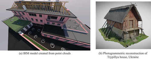
Another important result of the bilateral cooperation with Kiev was the joint establishment of a commercial company, SPM3D LLC. Building on the outstanding technical expertise of our Kiev colleagues in terrestrial laser scanning, an internationally active service company was thereby created, and which now employs 14 engineers. SPM3D is mainly engaged in the processing of point clouds to create drawings and 3D models for the BIM sector. In addition, the company also carries out photogrammetric projects, e.g. for the visualization of historical buildings or for the generation of highly accurate true orthophotos. shows two examples of work by SPM3D.
Figure 7. Examples of work done by SPM3D
5. Development of a virtual laser scanner
5.1. Objectives
Since 2019, the VirScan3D joint project between Jade University and KNUCA has been running in cooperation with the University of Bamberg (Chizhova et al. Citation2020). The project is financed through a DAAD program: support for the internationalization of Ukrainian higher education institutions – shaping the digital future together: German-Ukrainian higher education institution collaborations.
Teaching courses at Ukrainian universities that are related to digitization in engineering practice (e.g. geoinformation sciences, cadastral mapping, geodesy) should educate their students according to current professional needs and requirements. However, there is a lack of knowledge among many teachers, out-of-date equipment (hardware and software), an insufficient ICT infrastructure and insufficient finances for necessary investments. University curricula in Ukraine must be updated to accommodate these new technologies. For this purpose, appropriate tools and data must be provided, otherwise neither teachers nor students have realistic expectations of adapting to new methods in a reasonable time scale, and therefor they will not be able themselves to contribute to further developments.
The objective of the project is to develop a software tool to simulate mass data of objects recorded by a terrestrial laser scanner. These instruments create 3D point clouds from different stations that must further be registered (geo-referenced) and processed to higher-level information such as 3D models, architectural drawings, orthophotos or maps.
The project goal of digitization is achieved in two stages:
Development of a virtual environment for the creation and processing of digital 3D scan data
Digital teaching and e-learning material with interactive tools and practical experiences
Part 1 will be solved through the development of a virtual system that allows users to create realistic data in the absence of a real measuring device. The virtual scanner will be based on existing open-source software packages. This enables users to access the software free of charge and to promote future developments within the open-source community. It will be part of a general e-learning concept that will be implemented in both Ukrainian and German partner universities.
Part 2 is addressed through an integrated teaching concept that includes interactive learning tools (for both teachers and students) and practical exercises (for example, project weeks, summer schools) where the theoretical and virtual education is connected to practical experience with real instrumentation and data. One outcome of the experimental work is additional e-learning material based on the experiences and results of the project work. In addition, international project weeks will be organized for the students.
5.2. Software prototype
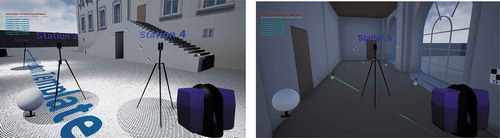
VirScan3D is developed within Unreal Engine (a well-known game engine). Its main functions are programmed with the Blueprint Visual Scripting system of Unreal Engine. It allows the system to be very flexible and enables software modules to be modified without recompiling the whole code. Some specific modules are programmed using C++ due to Blueprint limitations. It also allows the simulation of all the processes related to the fieldwork phase of terrestrial laser scanning and generates results that are very close to data generated with real physical scanners on-site. Back at the office, these results can be used for further processing in scanning software. shows an example of the current software version.
Figure 8. The virtual laser scanner
The product functionality includes the following features:
selecting which scanner type is to be simulated;
laser scanning process simulation with visualization and creation of point clouds with intensity and noise values according to scanner specifications;
scan station management, which allows the specification of settings for each scan station, and the creation and deletion of stations;
target management, which allows for placing and removing targets of different types;
project management, which enables the project to be saved for a particular user and continued later;
batch scanning;
real-time visualization of the generated point clouds;
exporting point clouds.
The simulator offers two work scenarios:
The user navigates within the virtual environment and selects target positions as in real life. Then scanner position and scan settings are specified and scanning is started. The scanning process is visualized in real time. When the scanning is finished, the user avatar “goes” to the next station.
The user navigates within the virtual environment and selects positions for all targets and all scan stations. Subsequently, scan settings are specified for all stations or for each station separately. Finally, the scanning simulation is started for all stations, one by one.
Scenario 1 is preferable for new users who only have basic knowledge of laser scanning technology, while scenario 2 is suited to users who have some experience of laser scanning and want to improve their skills by trying different scanning configurations.
The result of the simulation is a structured 3D point cloud in ASCII format for import into further software packages. For each scan station, a single point cloud is generated, hence no registration is provided. It is also possible to export target coordinates to use in registration software for cloud referencing.
6. Conclusions
This article summarizes the main activities and results of a German-Ukrainian cooperation, which has been active since 2011 between the Jade University in Oldenburg and KNUCA in Kiev. The cooperation includes the mutual exchange of students and scientists, the implementation of joint courses and professional cooperation in the academic field. The cooperation can be regarded as extremely successful, as sustainable structures have been established in both academic and professional areas. This has not only led to intensive and friendly contacts between German and Ukrainian students, but also to knowledge of, and interest in, each other’s working and living situations. The cooperation has also led to a modernization of the curriculum in geodesy at KNUCA, supported by an expansion of computational facilities and a comprehensive knowledge transfer for the benefit of the teaching staff. For his extensive activities, the author was awarded an honorary doctorate from KNUCA in 2018, the first for a foreign scientist.
Acknowledgments
I would like to thank the following individuals for their support in various ways (in alphabetical order): Maria Chizhova, Mona Hess, Sergej Mogilny, Tanja Kvartych, Denys Gorkovchuk, Julia Gorkovchuk, Gottfried Konecny, Roman Shults, Darius Popovas, Jurij Karpinskij, Andrea Menn, Ilze Peksa.
Additional information
Funding
Notes on contributors
Thomas Luhmann
Thomas Luhmann is a professor at Jade University of Applied Sciences, Oldenburg, Germany. He received his PhD degree from University of Hanover under the supervision of Prof. Gottfried Konecny and Prof. Wilfried Wester-Ebbinghaus. His research interests cover all aspects of close-range photogrammetry.
References
- Chizhova, M., D. Gorkovchuk, J. Gorkovchuk, D. Popovas, M. Hess, and T. Luhmann. 2020. “Virtual Terrestrial Laser Scanner Simulator for Digitalization of Teaching Environment - Concept and First Results.” In ISPRS International Archives of Photogrammetry, Remote Sensing and Spatial Information Sciences. XLIII-B5-2020, 91–97, https://doi.org/10.5194/isprs-archives-XLIII-B5-2020-91-2020
- Kravchenko, J., T. Luhmann, and R. Shults. 2016. “Concept and Practice of Teaching Technical University Students to Modern Technologies of 3D Data Acquisition and Processing: A Case Study of Close-range Photogrammetry and Terrestrial Laserscanning.” International Archives of the Photogrammetry, Remote Sensing and Spatial Information Sciences XLI-B6: 65–69. doi:10.5194/isprs-archives-XLI-B6-65-2016.
- Loser, R., and T. Luhmann. 1992. “The Programmable Optical Measuring System POM - Applications and Performance”. Comm. V, ISPRS Congress, Washington D.C.
- Luhmann, T., and W. Wester-Ebbinghaus. 1988. “Digital Image Processing by Means of Reseau-Scanning.” Allgemeine Vermessungs-Nachrichten 5(3): 13–18.
- Shults, R., M. Bilous, and V. Kovtun. 2019. “Monitoring and Preservation of the Kyiv Pechersk Lavra Caves.” ISPRS International Archives of Photogrammetry, Remote Sensing and Spatial Information Sciences XLII-2/W11: 1053–1058. doi:10.5194/isprs-archives-XLII-2-W11-1053-2019.
- Statistica. 2020. Accessed 25 August 2020. https://de.statista.com/statistik/daten/studie/232390/umfrage/bruttoinlandsprodukt-bip-in-der-ukraine/