
ABSTRACT
Since the beginning of the twenty-first century, several countries have made great efforts to develop space remote sensing for building a high-resolution earth observation system. Under the great attention of the government and the guidance of the major scientific and technological project of the high-resolution earth observation system, China has made continuous breakthroughs and progress in high-resolution remote sensing imaging technology. The development of domestic high-resolution remote sensing satellites shows a vigorous trend, and consequently, a relatively stable and perfect high-resolution earth observation system has been formed. The development of high-resolution remote sensing satellites has greatly promoted and enriched modern mapping technologies and methods. In this paper, the de velopment status, along with mapping modes and applications of China’s high-resolution remote sensing satellites are reviewed, and the development trend in high-resolution earth observation system for global and ground control-free mapping is discussed, providing a reference for the subsequent development of high-resolution remote sensing satellites in China.
1. Introduction
In 1957, the world’s first artificial satellite was launched by the former Soviet Union, opening the era of earth observation from space. In 1972, the United States’ first land observation satellite, Landsat-1, was successfully launched, realizing earth observation by a medium-resolution satellite. In 1986, France’s first earth resource observation satellite SPOT-1 was launched, opening the civilian market for remote sensing satellites. In 1994, the United States issued a PDD-23 order, liberating the export of 1 m high-resolution data and remote sensing satellite system, and promoting the development of high-resolution satellites.
In 1999, IKONOS, the first high-resolution commercial satellite with a resolution of 1 m, was launched in the United States, marking the beginning of a new age of commercial satellites (Li et al. Citation2017). The excellent observation capability of high-resolution satellites has immense military and economic benefits (Anderson et al. Citation2017; Dangermond and Goodchild Citation2020). Several countries are competing to develop a High-Resolution Earth Observation System (HREOS) (Li Citation2008), and many high-resolution satellites have been successfully launched, such as QuickBird, WorldView, Pleiades, CARTOSAT, etc. (Zhu et al. Citation2015, Citation2016a, Citation2016b; Woldai Citation2020). Under the joint proposal of many academicians in China’s remote sensing field, HREOS is listed as a major science and technology project (referred to as the GaoFen project) in the National Medium- and Long-term Scientific and Technological Development Planning Outline (2006–2020) (Tong Citation2016). The GaoFen project was launched and implemented in 2010 to build an independent and advanced HREOS, significantly promoting the improvement of the basic technology level of the entire remote sensing industry and driving the widespread development of high-resolution satellites in China (Zhao Citation2019).
The year 2020 is the last year of China’s GaoFen project. Over the past decade, China has independently developed, launched, and operated multiple series of high-resolution satellites, including ZiYuan series (ZY) and GaoFen series (GF) (Xu, Gong, and Wang Citation2014). The technology gap with foreign countries is narrowing, even reaching the leading level of similar satellites launched by other countries in the world. Private enterprises are being increasingly involved in the commercialization of remote sensing satellites, thus enriching independent high-resolution remote sensing data sources. China’s HREOS, led by GaoFen satellites and gathering various domestic satellites, has been formed to improve the sufficiency rate of independent high-resolution remote sensing data, as well as the timeliness of data acquisition.
Based on a summary and analysis of the development of China’s high-resolution satellites and commercial high-resolution satellites, this paper introduces mapping modes and applications of China’s high-resolution satellites, which help in understanding the progress of China’s high-resolution satellite and provide a reference for the future development of high-resolution satellites.
2. China’s high-resolution remote sensing satellite development
China began to develop high-resolution remote sensing satellites since the launch of the CBERS-02B satellite in 2007. The CBERS-02B satellite, jointly manufactured by China and Brazil, was first equipped with a 2.36 m high-resolution camera (Yuan and Wang Citation2012). It had been in orbit for 2 years and 7 months and was decommissioned in April 2010. In 2011, China launched an independently developed ZY-1 02C satellite, whose load performance was the same as that of CBERS-02B, replacing CBERS-02B for land resources survey.
In 2012, the first civilian high-resolution optical transmission mapping satellite of China, ZY-3, was launched (Li Citation2012). The Three-Line Array Camera (TLC) it is equipped with can achieve three-view stereo imaging with a resolution of 2.1 m in nadir view and 3.5 m in forward view and backward view. ZY-3 stereo images can be used to produce a topographic map with a scale of 1:50,000. In 2016, ZY-3 02 satellite was launched, operating in a network with the launched ZY-3 satellite. The resolution of the forward and backward images increased from 3.5 m to 2.5 m.
In 2013, the first satellite of the GaoFen project, GF-1, was launched, with the following imaging characteristics: high resolution of 2 m and width of 800 km (Cheng et al. Citation2017). In 2014, the first civilian sub-meter remote sensing satellite, GF-2, which has a spatial resolution better than 1 m (Huang et al. Citation2018), was launched. Subsequently, high-resolution geostationary satellite GF-4 with a maximum data rate of three image captures per minute (Wang et al. Citation2017a), hyperspectral satellite GF-5 with integrated observation capability of land and atmosphere (Sun et al. Citation2018), the first precision agriculture observation satellite GF-6 with ultra-large imaging width (Wang et al. Citation2019), stereo mapping satellite GF-7 with sub-meter resolution (Tang et al. Citation2019), etc. were launched successively.
In 2018, the first civilian high-resolution satellite constellation of China was launched, consisting of three satellites named GF-1 02/03/04 with the same performance and status (Zhu et al. Citation2018). After these three satellites were networked, they achieved an imaging ability of 15 days of global coverage and 2 days of revisit. These three satellites also cooperate with the GF-1 satellite launched in 2013 and can achieve 11 days of worldwide coverage and 1 day of revisit.
The main imaging parameters of the high-resolution remote sensing satellites launched in China are listed in . The spatial resolution, band number, and revisit period of remote sensing satellites are continually improving and the spectral range and coverage of observation are continually expanding. shows three GF-6 satellite images, including a panchromatic image, a multispectral image, and an ultra-wide coverage image. shows the panchromatic image with a resolution of 2 m acquired on 9 September 2019, covering Shijiazhuang, China. shows a multispectral image with a resolution of 8 m, corresponding to . shows an 800-km-wide WFV image acquired by the GF-6 satellite on 6 May 2019, covering Tianjin, Beijing, Hebei, and northern Shanxi.
Figure 1. P, MS, and WFV images acquired by the GF-6 satellite. (a) P, (b) MS (bands 4, 3, and 2), (c) WFV (bands 3, 2, and 1)
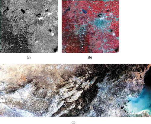
Table 1. Main parameters of China’s high-resolution remote sensing satellites
3. China’s commercial high-resolution remote sensing satellite development
With the rapid and continuous development of the aerospace industry, it is difficult for a high-resolution satellite built solely by the government to meet the growing demand for sub-meter high-resolution remote sensing data. In 2014, the State Council issued the Guiding Opinion on Innovation of Investment and Financing Mechanisms in Key Fields to Encourage Social Investment (document No. 60), which led private capital in China to participate in the application and development of the satellite industry. A large number of innovative enterprises focusing on commercial satellite research and development, as well as use, have emerged, such as Chang Guang Satellite Technology Co., Ltd. (CGSTL), Zhuhai Obita Aerospace Technology Co., Ltd. (Obita), Beijing Space View Technology Co., Ltd. (BSVT), and 21st Century Aerospace Technology Co., Ltd. (21AT). These continually promote the development of commercial high-resolution satellite constellations. At present, China’s commercial high-resolution remote sensing satellite constellations constructed by social financing mainly include TripleSat, Jilin-1, Zhuhai-1, and SuperView-1. The detailed satellite load parameters are listed in .
Table 2. Main parameters of China’s commercial high-resolution satellites
In 2015, a British-made TripleSat satellite constellation was launched (Wen et al. Citation2017), consisting of three optical remote sensing satellites with 1 m panchromatic and 4 m multispectral imaging ability. This satellite constellation can achieve 1 day of revisit.
In 2015, four of the Jilin-1 series satellites were launched with one rocket. Jilin-1 is China’s first truly independent commercial remote sensing satellite series (Zhong and Bao Citation2019). The four satellites are as follows: one optical satellite named GXA with 0.72 m panchromatic and 2.88 m multispectral imaging ability, two ultra-clear video satellites named SP01 and SP02 with a resolution of 1.12 m, and one smart verification satellite named LQ with a resolution of 5 m. Then, six video satellites named SP03–08, two multispectral satellites with 26 bands named GP01 and GP02, three panchromatic and multispectral optical satellites named GF03a, 02A, and 02B, and one wide swath-width satellite named KF01 were successively launched. After 9 launches, 16 satellites of Jilin-1 constellation are in orbit and operate in a network (Zhong et al. Citation2020), which can revisit any place in the world 5–7 times a day, providing sufficient remote sensing data for various fields.
In 2016, the SuperView-1 01 and 02 satellites were successfully launched with one rocket. In 2018, the SuperView-1 03 and 04 satellites were launched. Four of the SuperView-1 series satellites, with the same design parameters, operate in the same orbital network with a resolution of 0.5 m and can revisit any target for 1 day (Wang, Jin, and Zhu Citation2018). The SuperView-1 satellite constellation is China’s first commercial satellite constellation that can achieve high agility and multi-mode imaging. BSVT is responsible for the global commercial operation of this constellation. It will be completely built by 2022.
Since 2017, a commercial micro-nano satellite constellation of Zhuhai-1 has been launched (Jiang et al. Citation2019). Obita plans to launch 34 satellites for this satellite constellation. Thus far, three batches of 12 satellites were launched. The first batch includes two video satellites named OVS-1A and 1B, which can obtain high-resolution color video data with a resolution better than 1.98 m. The second batch consists of one video satellite named OVS-2 and four hyperspectral satellites named OHS-01, 02, 03, and 04. The spatial resolution of the OVS-2 satellite has been increased from 1.98 m of OVS-1 to 0.9 m. The OHS-01, 02, 03, and 04 satellites can acquire hyperspectral data in 256 bands. The satellite data and types of the third batch are the same as those of the second batch.
4. High-resolution optical satellite mapping mode development and application
With the continuous improvement in the performance and variety of high-resolution satellites, mapping by high-resolution satellite has emerged as a successful means to obtain necessary geographic information, an essential national fundamental strategic resource (Li and Wang Citation2020; Li, Shao, and Zhang Citation2020). Based on the principle of photogrammetry, mapping by a high-resolution optical satellite mainly complete the elevation survey by obtaining the same-orbit or different-orbit visual stereo images from different views in the same region. Mapping modes have three main forms: TLC, DLC, and Single-Line Array/Area Array Camera (SLC/SAC). This section considers typical domestic mapping satellites as examples to introduce high-resolution optical satellite mapping mode and application.
4.1. ZY-3 mapping satellite
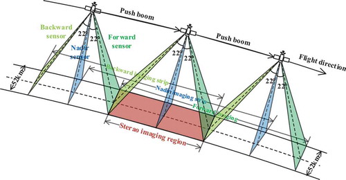
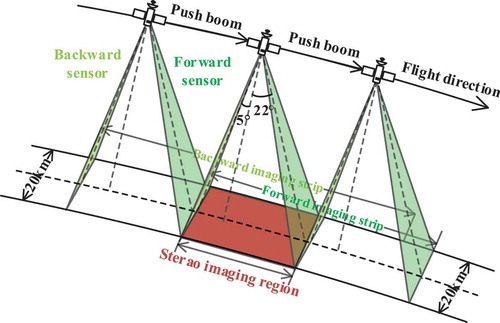
The ZY-3 satellite is China’s first-generation high-resolution civilian stereo mapping satellite. The TLC mounted on the satellite is the earliest spaceborne photogrammetry method adopted in China. TLC consists of forward, backward, and nadir linear array push-broom sensors. The stereo imaging mode of the TLC is shown in . The Nadir sensor is vertical to the point under the satellite, the forward sensor is tilted forward by +22° from the nadir sensor, and the backward sensor is tilted backward by −22°. TLC is pushed continuously along the flight direction to generate three overlapping strip images with a width of 52 km. Thus, three-view stereo images of the same ground point are obtained. Based on the construction of strict object-image space relations, the object coordinates of the corresponding image points in stereo images can be calculated by forward intersection. Then, a topographic map can be drawn.
Figure 2. TLC stereo imaging mode
The spatial resolution of the nadir sensor is 2.5 m, while that of the forward and backward sensors is 3.5 m. A nadir image has a relatively high spatial resolution and the projection difference caused by terrain relief can be minimized by imaging vertical to the ground. Nadir images are used to produce high-resolution orthophotos, and three-view stereo images are used to calculate elevation. The ZY-3 satellite is also equipped with a 6.8 m multispectral sensor, including blue, green, red, and near-infrared spectral bands. After the fusion of multispectral images and high-resolution panchromatic images, the interpretation accuracy of ground objects can be improved. Since its launch in 2012, ZY-3 satellite data have been used in many mapping applications, fully supporting the major national surveying and mapping projects, such as the dynamic update of the national 1:50,000 primary geographic information database, the first national geographic census, and the production of 1:25,000 data surface models in western areas (Tang, Chang, and Li Citation2014)
Considering 150 TLC images covering Shandong Province as test data (shown in ), the mapping accuracy of the ZY-3 satellite was tested by using 1090 field-measured high-precision Global Positioning System (GPS) checkpoints. The geometric positioning accuracy of the ZY-3 images before and after Block Adjustment (BA) without Ground Control Points (GCPs) is shown in . Before BA, the positioning accuracy of the images was weak, and there was no obvious systematic error. After BA, the Root Mean Square Error (RMSE) of the plane and elevation was better than 5 m and the overall accuracy of the images was uniform. At the same time, elevation accuracy of ZY-3 could be further improved to within 3 m by using Laser Altimeter Data (LAD) acquired by Geoscience Laser Altimeter System (GLAS) equipped on Ice, Cloud, and Land Elevation Satellite (ICESat) to assist in the BA.
Figure 3. ZY-3 TLC images covering Shandong Province
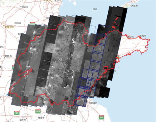
Table 3. Mapping accuracy of ZY-3 satellite
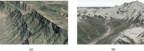
With the support of processing technologies like BA without GCPs and high-performance computing, Wuhan University and other centers have studied large-scale and high-precision mapping technology and software without GCPs, demonstrating applications using tens of thousands of TCL images from the ZY-3 satellite throughout the country (Yang et al. Citation2017; Wang et al. Citation2017b). A high-precision mapping result of ZY-3 is shown in ). International cooperative research on high mountain mapping was carried out by the Beijing University of Civil Engineering and Architecture, Leibniz University Hannover, the European Academy of Sciences and Arts in Salzburg, and Environmental Systems Research Institute (ESRI). China has completed high mountain mapping of the Nanga Parbat region in the westernmost part of the Himalayas using ZY-3 images, based on the mapping technology developed by Wuhan University and domestic software, as shown in ). This mapping result will be compared with the historical maps made by Germany from 1930 to the 1980s and maps produced by using other satellite imagery and software by ESRI. Environmental changes in this region in recent decades will be analyzed later.
Figure 4. High mountain mapping results by China. (a) High-precision mapping result. (b) Mapping result of Nanga Parbat region
4.2. GF-7 mapping satellite
The GF-7 satellite is China’s second-generation civilian high-resolution stereo mapping satellite. Its main task is to realize civilian 1:10,000 scale satellite stereo mappings in China. The DLC it is equipped with has a sub-meter resolution (Liu et al. Citation2018). The forward sensor is tilted forward by +26° to acquire a panchromatic image with a resolution of 0.8 m. The backward sensor is tilted backward by –5°, which can obtain panchromatic and multispectral images with resolutions of 0.65 m and 2.6 m, respectively. Stereo imaging mode of DLC is shown in . DLC is pushed along the flight direction to generate two overlapping strip images with a width of 20 km to obtain a two-view stereo image of the same ground point. Similar to the TLC of ZY-3, the object point coordinates can be calculated by the forward intersection of the corresponding image points for DLC. However, the difference between TLC and DLC is that TLC can achieve a three-view crossing, while DLC can achieve a two-view crossing.
Figure 5. DLC stereo imaging mode
The DLC of the GF-7 satellite adopts an asymmetrically designed imaging intersection. Forward and backward panchromatic images can be used to generate stereo images and backward images with approximately vertical imaging can be used to produce orthophotos. To solve the problem of 1:10,000 scale mapping in China’s “fewer control points” region, GF-7 is also equipped with a 2-beam laser altimeter, which can obtain LAD with an elevation accuracy better than 1 m. LAD can assist in BA processing in subsequent ground processing, thus improving the satellite’s elevation mapping accuracy further. The GF-7 satellite has passed in-orbit testing. Its preliminary evaluation shows that the performance of the GF-7 satellite can satisfy the accuracy of 1:10,000 scale mapping (Cao et al. Citation2020)
4.3. Single-line array/area array mapping satellite
Unlike professional mapping satellites, such as ZY-3 and GF-7, high-resolution remote sensing satellites equipped with a single camera have specific mapping capabilities. These satellites, equipped with a SLC or a SAC, mainly use attitude maneuvers to conduct multi-view observations of the same object, such as the SuperView-1 satellite and Jilin-1 video satellite. The stereo imaging modes of SLC and SAC are shown in and , respectively. During a satellite’s flight along one orbit, the imaging attitude of the satellite is adjusted, while the SLC pushes and scans the same object along the satellite’s flight direction. With attitude conditions permitting, SLC can obtain image pairs with multiple base-height ratios. SAC does not need to push and scan and one exposure can obtain one image. Through attitude adjustment, SAC can also achieve multi-view imaging for the same region (Zhong and Bao Citation2019).
Figure 6. SLC stereo imaging mode
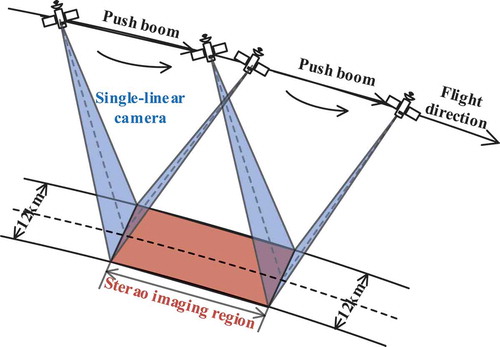
Figure 7. SAC stereo imaging mode
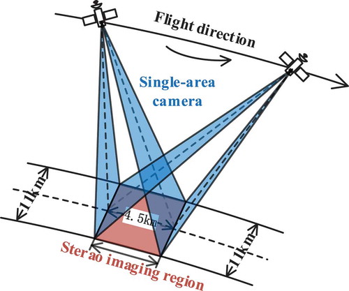
Mapping satellites equipped with SLC or SAC for multi-view stereo observation require high-stability attitude control and high-precision attitude and orbit parameter measurement. Although the resolution of SLC and SAC can reach the sub-meter level, they have weak geometric control strength compared to the stable mapping modes of TLC and DLC. Considerable ground control is required for SLC and SAC to achieve large-scale mapping. Moreover, the imaging width of SLC and SAC is limited by its sub-meter resolution, for example, the swath width of the SuperView-1 satellite with a spatial resolution of 0.5 m is only 12 km. Therefore, the mapping object of SLC and SAC is mainly oriented to the small local region of the crucial target.
5. Conclusions
Herein we reviewed the development of China’s high-resolution remote sensing satellites and their applications in mapping. The development of China’s high-resolution remote sensing satellites has made significant progress. Single satellite performance is increasing, multi-satellite networking has emerged as a trend, and satellite commercialization is steadily advancing. With the beneficial supplement of commercial high-resolution remote sensing satellites, high-resolution remote sensing satellite observation system is becoming increasingly abundant and complete. There is an increasing number of high-resolution satellite mapping modes, including TLC, DLC, and SLC/SAC, which can meet the mapping requirements of 1:50,000 worldwide and 1:10,000 nationwide. However, the task of global coverage and mapping updating remains arduous. A ground control-free mapping system needs to be further developed and new mapping technologies, such as radar satellite interferometry and laser altimeter, must be continuously broken to complement the traditional optical satellite mapping means. High-resolution remote sensing satellite observation system needs to be further improved to better serve the mapping application.
Acknowledgments
Thanks for the support of China Centre for Resources Satellite Data and Application (CRESDA).
Disclosure statement
No potential conflict of interest was reported by the authors.
Data availability statement
The raw data used to support the findings of this study have not been made available and shared at this time as the data also form part of an ongoing study. The ZY-3 data used and other China satellite data can be queried and downloaded from the website of China Centre for Resources Satellite Data and Application (CRESDA) (http://www.cresda.com/CN/).
Additional information
Funding
Notes on contributors
Deren Li
Deren Li is a professor and chair of the Academic Committee of the State Key Laboratory for Information Engineering in Surveying, Mapping, and Remote Sensing, Wuhan University. He was selected as a member of Chinese Academy of Sciences in 1991 and a member of Chinese Academy of Engineering in 1994. He got his PhD degree from University of Stuttgart, Germany. He was awarded the title of honorary doctor from ETH, Switzerland in 2008. His research interests include photogrammetry and remote sensing, global navigation satellite system, geographic information system, and their innovation integrations and applications.
Mi Wang
Mi Wang is a professor at the State Key Laboratory of Information Engineering in Surveying, Mapping, and Remote Sensing, Wuhan University. He received the PhD degree from Wuhan University in 2001. His research interests include high-resolution remote sensing satellite ground processing and the integration and rapid update of photogrammetry and GIS.
Jie Jiang
Jie Jiang is a professor at School of Geomatics and Urban Spatial Informatics, Beijing University of Civil Engineer and Architecture. She received the PhD degree from China University of Mining and Technology (Beijing) in 2000. Her research interests include satellite remote sensing information extraction, network geographic information service, and indoor and outdoor navigation geographic data model.
References
- Anderson, K., B. Ryan, W. Sonntag, A. Kavvada, and L. Friedl. 2017. “Earth Observation in Service of the 2030 Agenda for Sustainable Development.” Geo-spatial Information Science 20 (2): 77–96. doi:10.1080/10095020.2017.1333230.
- Cao, H., J. Dai, X. Zhang, C. Zhao, F. Liu, A. Guo, and C. Xu. 2020. “Study on the Development Approach of GF-7 High Precision Optical Stereo Mapping Satellite.” Spacecraft Recovery & Remote Sensing 41 (2): 17–28. doi:10.3969/j.1009-8518.2020.02.003.
- Cheng, Y., S. Jin, M. Wang, Y. Zhu, and Z. Dong. 2017. “A New Image Mosaicking Approach for the Multiple Camera System of the Optical Remote Sensing Satellite GaoFen1.” Remote Sensing Letters 8 (11): 1042–1051. doi:10.1080/2150704X.2017.1349960.
- Dangermond, J., and M. F. Goodchild. 2020. “Building Geospatial Infrastructure.” Geo-spatial Information Science 23 (1): 1–9. doi:10.1080/10095020.2019.1698274.
- Huang, W., S. Sun, H. Jiang, C. Cao, and X. Zong. 2018. “GF-2 Satellite 1m/4m Camera Design and In-orbit Commissioning.” Chinese Journal of Electronics 27 (6): 1316–1321. doi:10.1049/cje.2018.09.018.
- Jiang, Y., J. Wang, L. Zhang, G. Zhang, X. Li, and J. Wu. 2019. “Geometric Processing and Accuracy Verification of Zhuhai-1 Hyperspectral Satellites.” Remote Sensing 11 (9): 996. doi:10.3390/rs11090996.
- Li, D. 2008. “Development Prospect of Photogrammetry and Remote Sensing.” Geomatics and Information Science of Wuhan University 12 (33): 1211–1215.
- Li, D. 2012. “China’s First Civilian Three-line-array Stereo Mapping Satellite: ZY-3.” Acta Geodaetica et Cartographica Sinica 41 (3): 317–322.
- Li, D., Z. Shao, and R. Zhang. 2020. “Advances of Geo-spatial Intelligence at LIESMARS.” Geo-spatial Information Science 23 (1): 40–51. doi:10.1080/10095020.2020.1718001.
- Li, D., and M. Wang. 2020. “A Review of High Resolution Optical Satellite Surveying and Mapping Technology.” Spacecraft Recovery & Remote Sensing 41 (2): 1–11.
- Li, D., M. Wang, Z. Dong, X. Shen, and L. Shi. 2017. “Earth Observation Brain (EOB): An Intelligent Earth Observation System.” Geo-spatial Information Science 20 (2): 134–140. doi:10.1080/10095020.2017.1329314.
- Liu, J., J. Zhang, Z. Li, G. Zhang, W. Du, W. Zhao, and J. Liu. 2018. “Technical Framework of 1:10000 Cartographic Element Extraction Based on GF-7 Satellite.” Geomatics World 25 (6): 58–61+67. doi:10.3969/j..1672-1586.2018.06.011.
- Sun, Y., G. Jiang, Y. Li, Y. Yang, H. Dai, J. He, Q. Ye, et al. 2018. “GF-5 Satellite: Overview and Application Prospects.” Spacecraft Recovery & Remote Sensing 39 (3): 1–13. doi:10.3969/j..1009-8518.2018.03.001.
- Tang, X., X. Chang, and G. Li. 2014. “Achieve ‘One Star with Multiple Uses’ to Ensure the Safety of Geographic information——Summary of Surveying and Mapping Satellite Images of ZY-3.” Satellite Applications 30 (6): 15–20.
- Tang, X., J. Xie, R. Liu, G. Huang, C. Zhao, Y. Zhen, H. Tang, and X. Dou. 2019. “Overview of the GF-7 Laser Altimeter System Mission.” Earth and Space Science 7: 2. doi:10.1029/2019EA000777.
- Tong, X. D. 2016. “Development of China High-resolution Earth Observation System.” Journal of Remote Sensing 20 (5): 775–780. doi:10.11834/jrs.20166302.
- Wang, M., Y. Cheng, X. Chang, S. Jin, and Y. Zhu. 2017a. “On-orbit Geometric Calibration and Geometric Quality Assessment for the High-resolution Geostationary Optical Satellite GaoFen4.” ISPRS Journal of Photogrammetry & Remote Sensing 125 (MAR.): 63–77. doi:10.1016/j.isprsjprs.2017.01.004.
- Wang, M., Y. Cheng, B. Guo, and S. Jin. 2019. “Parameters Determination and Sensor Correction Method Based on Virtual CMOS with Distortion for the GaoFen6 WFV Camera.” ISPRS Journal of Photogrammetry and Remote Sensing 156: 51–62. doi:10.1016/j.isprsjprs.2019.08.001.
- Wang, M., B. Yang, D. Li, J. Gong, and Y. Pi. 2017b. “Technologies and Applications of Block Adjustment without Control for ZY-3 Images Covering China.” Geomatics and Information Science of Wuhan University 42 (4): 427–433. doi:10.13203/j.whugis20160534.
- Wang, S., R. Jin, and J. D. Zhu. 2018. “SuperView-1-China’s First Commercial Remote Sensing Satellite Constellation with a High Resolution of 0.5m.” Aerospace China 1: 31–38. doi:10.3969/j..1671-0940.2018.01.005.
- Wen, Q., J. He, S. Guan, T. Chen, Y. Hu, W. Wu, F. Liu, Y. Qiao, S. Y. Kok, and S. Yeong. 2017. “The TripleSat Constellation: A New Geospatial Data Service Model.” Geo-spatial Information Science 20 (2): 163–173. doi:10.1080/10095020.2017.1329266.
- Woldai, T. 2020. “The Status of Earth Observation (EO) & Geo-Information Sciences in Africa – Trends and Challenges.” Geo-spatial Information Science 23 (1): 107–123. doi:10.1080/10095020.2020.1730711.
- Xu, W., J. Gong, and M. Wang. 2014. “Development, Application, and Prospects for Chinese Land Observation Satellites.” Geo-spatial Information Science 17 (2): 102–109. doi:10.1080/10095020.2014.917454.
- Yang, B., M. Wang, W. Xu, D. Li, J. Gong, and Y. Pi. 2017. “Large-scale Block Adjustment without Use of Ground Control Points Based on the Compensation of Geometric Calibration for ZY-3 Images.” ISPRS Journal of Photogrammetry and Remote Sensing 134: 1–14. doi:10.1016/j.isprsjprs.2017.10.013.
- Yuan, X. X., and T. Y. Wang. 2012. “Block Adjustment for CBERS-02B Satellite Images.” Journal of Remote Sensing 16 (2): 310–324.
- Zhao, W. B. 2019. “Phase Research and Practice of Upgrading Earth Observation from Test Application to System Effectiveness in China.” Journal of Remote Sensing 23 (6): 1036–1045. doi:10.11834/jrs.20199162.
- Zhong, X., Y. An, D. Wang, L. Dai, L. Zhang, and K. Xu. 2020. “Jilin-1 Commercial Space Remote Sensing Service System Construction.” Satellite Applications 2020 (3): 8–17.
- Zhong, X., and S. Bao. 2019. “Application Advantages of Staring Area Imaging Technology (SAIT) for Microsatellites.” Aerospace China 20 (1): 30–41. doi:10.3969/j.1671-0940.2019.01.005.
- Zhu, R., Y. Cong, H. Wang, and Z. Bai. 2016b. “Global High-resolution Optical Satellite Overview (3): Asia and Russia.” Spacecraft Engineering 25 (2): 70–96. doi:10.3969/j.1673-8748.2016.02.012.
- Zhu, R., Y. Cong, H. Wang, H. Qiu, and Z. Bai. 2016a. “Global High-resolution Optical Satellite Overview (2): Europe.” Spacecraft Engineering 25 (1): 95–118. doi:10.3969/j.1673-8748.2016.01.015.
- Zhu, R., Y. Cong, H. Wang, Y. Xu, and Z. Bai. 2015. “Global High-resolution Optical Satellite Overview (1): USA and Canada.” Spacecraft Engineering 024 (6): 85–106. doi:10.3969/j.1673-8748.2015.06.015.
- Zhu, Y., M. Wang, Y. Cheng, L. He, and L. Xue. 2018. “An Improved Jitter Detection Method Based on Parallax Observation of Multispectral Sensors for Gaofen-1 02/ 03/04Satellites.” Remote Sensing 11 (1): 16. doi:10.3390/rs11010016.