
ABSTRACT
The Austrian node of the Natural Resources Satellite Remote Sensing Cloud Service Platform was established in 2016 through a cooperation agreement between the Land Satellite Remote Sensing Application Center (LASAC), Ministry of Natural Resources of the Peoples Republic of China and the University of Vienna, Austria. Under this agreement panchromatic and multispectral data of the Chinese ZY-3 satellite are pushed to the server at the University of Vienna for use in education and research. So far, nearly 500 GB of data have been uploaded to the server. This technical note briefly introduces the ZY-3 system and illustrates the implementation of the agreement by the first China-Sat Workshop and several case studies. Some of them are already completed, others are still ongoing. They include a geometric accuracy validation of ZY-3 data, an animated visualization of image quick views on a spherical display to demonstrate the time series of the image coverage for Austria and Laos, and the use of ZY-3 data to study the spread of bark beetle in the province of Lower Austria. An accuracy study of DTMs from ZY-3 stereo data, as well as a land cover analysis and comparison of Austria with ZY-3 and other sensors are still ongoing.
1. Introduction
The Department of Geography and Regional Research of the University of Vienna was founded in 1885. It is the oldest and largest geography department in Austria offering two bachelor programs, 5 master programs, and 2 PhD programs. The research group on Cartography and Geographic Information Science has a long-standing cooperation with scientific organizations in China in the domain of geographic information systems and remote sensing, in particular with the Land Satellite Remote Sensing Application Center (LASAC), Ministry of Natural Resources of the Peoples Republic of China and Wuhan University.
In October 2016 a technical cooperation agreement was signed between LASAC (formerly called SASMAC)Footnote1 and the University of Vienna (). The agreement defines activities in mutual interest including among others the following items:
LASAC will arrange ZY-3 satellites to acquire images of Austria upon the request of the University of Vienna.
LASAC will provide ZY-3 data and data processing service to the University of Vienna, such as free-of-charge images of ZY-3 satellites and other necessary image products, according to the requirement of the university for research projects.
The University of Vienna will cooperate in the node construction of the ZY-3 satellite image cloud service platform in Austria and promote ZY-3 satellite data global applications.
The University of Vienna will support LASAC by using the data for ZY-3 data and products verification and related visualizations.
LASAC and the University of Vienna will jointly carry out satellite surveying, mapping and geo-information application technology research, personnel exchanges and cooperation, jointly carry out the projects and seek for financial support from Chinese and European sources.
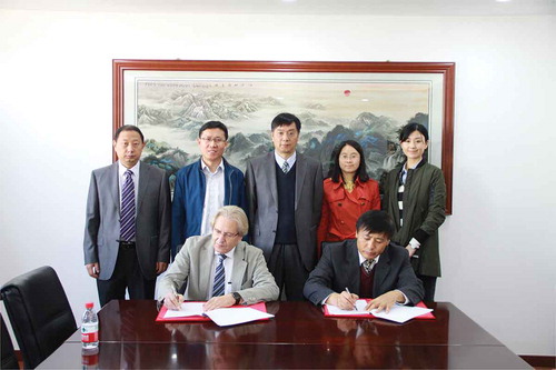
Figure 1. Signing of the cooperation agreement between LASAC and the University of Vienna by Q. Wang (LASAC) and W. Kainz (University of Vienna) (Source: LASAC)
The objective of this paper is to document and illustrate the implementation of the cooperation agreement. The next section describes the ZY-3 system and the cloud platform, followed by a section on sample activities and applications in the context of the agreement.
2. Chinese ZY-3 satellites and cloud platform
With the successful launch of China’s first civil stereo imaging satellite ZY-3-01 and three satellites ZY-3-01, ZY-3-02, ZY-3-03 networking, the ZY-3 satellite system becomes a fundamental means of data acquisition for 1:50,000 scale mapping and geographic information updating in China (Gong, Wang, and Yang Citation2017; Liu et al. Citation2012; Pan et al. Citation2013; Tang et al. Citation2015; Wang et al. Citation2014; Xu et al. Citation2017). The updating period of 1:50,000 scale 4D products in China has improved significantly to less than one year. Utilizing ZY-3 satellites images, China’s national 2 m Ground Sample Distance (GSD) Digital Orthorectified Image (DOM) and 15 m/10 m grid Digital Surface Model (DSM) database has been constructed, which is updated annually and biennially to meet various needs for high precision geo-information products. ZY-3 satellites play a significant role in providing high accuracy geoinformation data for national major surveying and mapping projects. After more than eight years of stable and continued earth observation, ZY-3 satellites data coverage has gradually achieved more than half of the earth’s land which enables the overseas service for global geospatial applications.
ZY-3 satellites map with three independent cameras looking at forward, nadir, and backward, respectively, with 2.1 m GSD nadir images having an interior orientation accuracy of less than one pixel after calibration. The ZY-3-03 elevation measurement accuracy of a single laser point is better than 1 m with point spacing of 3.6 km, which networks with ZY-3-01/02 to establish China’s optical satellite constellation for 1:50,000 scale stereo image mapping, shortening the re-visit period from 3 days to 1 day at the same place, and ensuring the long-term, stable high-resolution stereo image acquisition for national surveying and mapping.
For the multi-spectral camera images with a 5.8 m GSD and four spectral bands including blue, green, red and near infrared, the registration accuracy of multispectral bands is less than 0.15 pixels. The DSM generated from triplet view images ensures stable high accuracy and good quality especially in mountainous areas (Xue Citation2015). It is used for terrain correction of the multi-spectral images and can effectively improve the accuracy of biomass estimation (Gao et al. Citation2014; Yang et al. Citation2015; Wang et al. Citation2015; Zhao et al. Citation2018; Kovacs et al. Citation2018).
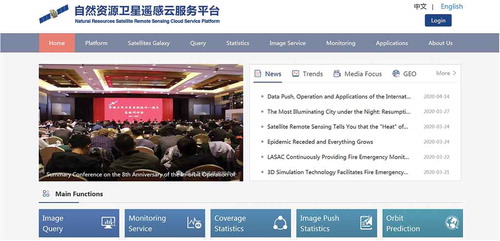
Focusing on the domestic mapping applications and services, the data of ZY-3 and other domestic land observation satellites can be pushed in real-time and across China, and even worldwide through the satellite cloud service platform (), which is promoted through the intergovernmental Group on Earth Observations (GEO). The overseas service nodes of the satellite remote sensing cloud service platform for ZY-3 and other Chinese domestic high-resolution satellites data distribution, have been expanded to 18 countries outside China in order to promote China’s satellites remote sensing technique, data and geographic information services (for the website refer to: http://sasclouds.com). One of these nodes is implemented at the Department of Geography and Regional Research at the University of Vienna.
Figure 2. Natural resources satellite remote sensing cloud service platform
3. Applications of ZY-3 data and activities in Austria
This section highlights activities that have been carried out to increase the knowledge about Chinese earth observation systems, to strengthen scientific exchange between China and Austria, and sample projects using ZY-3 data for applications in Austria and Laos.
3.1. First China-sat workshop
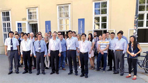
In June 2018 the first China-Sat Workshop was held at the University of Vienna to report on and to promote the use of Chinese satellite systems data. The workshop brought together researchers from China and Austria () among whom the chief engineer of LASAC and designer of the ZY-3 satellite Dr. X.M. Tang (first row, first left), Prof. J.Y. Gong, academician of the Chinese Academy of Sciences (first row, third from left) and professors from Tongji University, The Hong Kong Polytechnic University, Hong Kong Baptist University, researchers from LASAC as well as international representatives from academia and industry. The second China-Sat Workshop planned for September 2020 had to be canceled due to the COVID-19 pandemic and will take place at a later date.
Figure 3. Participants of the First China-Sat Workshop on 11 June 2018 (Source: Austrian Cartographic Commission)
3.2. Geometric accuracy validation of ZY-3 data in Austria
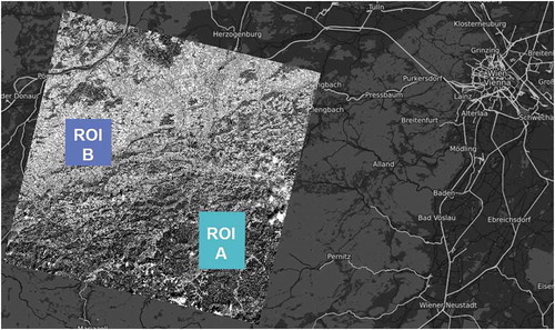
The overseas geometric accuracy evaluation and validation for ZY-3 satellite images was conducted in cooperation with the University of Vienna, Austria, for the accuracy evaluation of primary locations to provide a technical guideline for global mapping applications. Through the evaluation of the image direct location accuracy of sensor corrected nadir images in Austria, the evaluation results show stable consistency with mapping practices in China (Tang et al. Citation2015; Gong, Wang, and Yang Citation2017). In order to verify the overseas location accuracy of ZY-3 satellites sensor corrected image products, one scene of ZY-3-02 satellite nadir image of 8 August 2016 covering the test sites was chosen for image direct location accuracy evaluation. The University of Vienna, Austria, used the open-government 30-centimeter resolution aerial images as the control data, selected a total of 11,670 densely and evenly distributed control points in a 100 square kilometers mountainous area shown as Region of Interest (ROI) A and 2,600 control points in a 80 square kilometers flat area shown in ROI B, respectively, to evaluate the primary location accuracy of ZY-3 nadir image (). The potential for local 1:50,000 and 1:25,000 mapping was demonstrated and validated for global geographic information applications by Xue et al. (Citation2020).
Figure 4. ROI A and ROI B in Austria for direct location accuracy evaluation in Austria (Xue et al. Citation2020)
3.3. Animated visualization of ZY-3 coverage for Austria and Laos
In the context of a project on “High Precision Composite Mapping Technology based on China’s Aerospace Remote Sensing Images and Its Application” the University of Vienna provided animated visualizations of the ZY-3 coverage for Austria and Laos. The animations were realized on a hyperglobe. This is a 3D visualization device capable of projecting images onto a sphere using projector technology ().
Figure 5. Hyperglobes (Source: Department of Geography and Regional Research, University of Vienna)
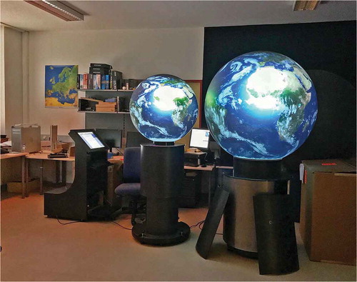
The Hyperglobe Research Group of the Department of Geography and Regional Research, University of Vienna, led by Dr. A. Riedl, is conducting research and development to control the hyperglobes through the OmniSuite software (Globoccess Citation2020). This software can be used to create globe stories and to control the display on the hyperglobe. The great advantage of hyperglobes over traditional globes or virtual globes is that they are real 3D displays where viewers may walk around them and view the displayed image from arbitrary positions with animation effects. Hyperglobes are an ideal means to display global phenomena on a virtually animated 3D display surface for larger groups of spectators.
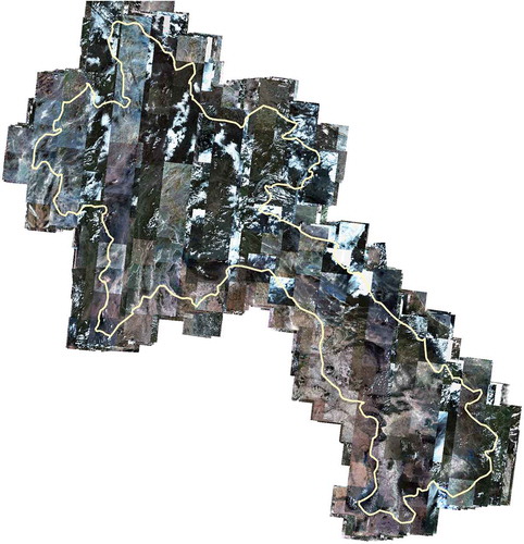
The coverage animation for Austria and Laos was realized as a technical seminar assignment by a group of students (Babka et al. Citation2020). shows the time-series coverage of ZY-3 scenes for Austria; the coverage for Laos is shown in .
Figure 6. ZY-3 coverage of Austria (343 quick views)
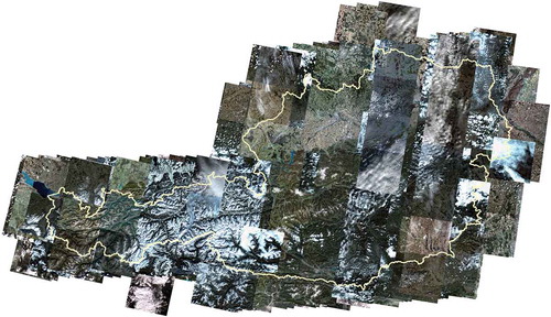
Figure 7. ZY-3 coverage for Laos (3,666 quick views)
3.4. Other activities
ZY-3 satellite data can be successfully applied for information extraction of inland wetland habitats, to provide the technological basis and data for environmental dynamic monitoring and comprehensive evaluation. Besides the presented applications several other activities were carried out using ZY-3 data for applications in Austria. The suitability of ZY-3 data vs Sentinel-2 data to detect pest infestations on the example of bark beetle infestation in Lower Austria was conducted by Gerl (Citation2020). Ongoing master theses research work is carried out to analyze the quality of digital terrain models generated from ZY-3 stereo data as well as to conduct a land cover analysis for Austria with ZY-3 data.
4. Conclusions
In terms of DSM generation, the multi-view stereoscopic images of ZY-3 satellites have technical advantages in DSM production with higher accuracy for the highly varied terrain of mountainous areas. At the same time, the advantages of ZY-3 stereo images can be applied to timely obtain 3D terrain information of the research area, and the high precision terrain correction processing of the multi-spectral remote sensing image can be used to effectively improve the accuracy of biomass information quantitative derivation. Through the satellite based geographic information technology cooperation between Austria and China more practical studies on ZY-3 images performance evaluation and validation will be carried out in the future to guide and consolidate the global applications.
Through actively participating in geographic information technology cooperation with the international organization of GEO, and steadily implementing the Chinese Global Earth Observation System of Systems (GEOSS) ten-year implementation plan, the overseas node construction of ZY-3 satellites images cloud services platform has been expanded worldwide to promote geographic information applications of ZY-3 satellite data and gradually strengthen practical cooperation with the countries along the Belt and Road.
Acknowledgments
We would like to thank LASAC for providing satellite data to conduct this research and M. Holzapfel, Department of Geography and Regional Research, University of Vienna, Austria, for the data processing for the accuracy evaluation of ZY-3 image in Austria.
Disclosure statement
No potential conflict of interest was reported by the author.
Data availability statement
The data that support the findings of this study are available from Land Satellite Remote Sensing Application Center, Ministry of Natural Resources of the Peoples Republic of China. Restrictions apply to the availability of these data, which were used under license for this study. Data are available from the authors with the permission of Land Satellite Remote Sensing Application Center. http://www.lasac.cn
Additional information
Funding
Notes on contributors
Wolfgang Kainz
Wolfgang Kainz is a full professor of cartography and geo-information science at the Department of Geography and Regional Research, University of Vienna, Austria. He received his PhD degree from Graz University of Technology, Austria. His research interests are mathematical foundations of GIS, fuzzy logic, and topology.
Xinming Tang
Xinming Tang is the chief engineer of Land Satellite Remote Sensing Application Center (LASAC), Ministry of Natural Resource (MNR), and chief scientist of technology innovation team, Ministry of Science and Technology, China. He received his PhD degree from Twente University, The Netherlands. His research interests are satellite data processing and application, spatial and temporal database.
Yucai Xue
Yucai Xue is a research associate of Land Satellite Remote Sensing Application Center (LASAC), Ministry of Natural Resource (MNR), China. She received her PhD degree from the Chinese University of Hong Kong, China. Her research interests are satellites data onboard compression and remote sensing applications.
Notes
1. Before an organizational reform in 2018 LASAC used to be the Satellite Surveying and Mapping Application Center (SASMAC) of the National Administration of Surveying, Mapping and Geoinformation of China.
References
- Babka, G., V. Bajakic, F. Fassler, and B. Ritzberger 2020. “Animation of Satellite Image Coverage of Austria and Laos with ZY-3 Data,” Project report, Dept. of Geography and Regional Research, University of Vienna (in German).
- Gao, M. L., W. J. Zhao, Z. N. Gong, H. L. Gong, Z. Chen, and X. M. Tang. 2014. “Topographic Correction of ZY-3 Satellite Images and Its Effects on Estimation of Shrub Leaf Biomass in Mountainous Areas.” Remote Sensing 6 (4): 3141–3151. doi:10.3390/rs6042745.
- Gerl, J. 2020. “Die Eignung von ZY-3 Satellitendaten vs. Sentinel-2 Daten zu Schädlingsdetektion am Beispiel Borkenkäferbefall im Waldviertel.” Master Thesis, University of Vienna.
- Globoccess. 2020. Accessed 28 August 2020. https://globoccess.de/
- Gong, J. Y., M. Wang, and B. Yang. 2017. “High-precision Geometric Processing Theory and Method of High Resolution Optical Remote Sensing Satellite Imagery without GCP.” Acta Geodaetica et Cartographica Sinica 46 (10): 1255–1261.
- Kovacs, E., C. Roelfsema, M. Lyons, S. H. Zhao, and S. Phinn. 2018. “Seagrass Habitat Mapping: How Do Landsat 8 OLI, Sentinel-2, ZY-3a, and Worldview-3 Perform?” Remote Sensing Letters 9 (7): 686–695. doi:10.1080/2150704X.2018.1468101.
- Liu, B., X. Sun, K. Di, and Z. Liu. 2012. “Accuracy Analysis and Validation of ZY-3’s Sensor Corrected Products.” Remote Sensing for Land & Resources 24 (4): 36–40.
- Pan, H. B., G. Zhang, X. M. Tang, and P. Zhou. 2013. “The Geometrical Model of Sensor Corrected Products for ZY-3 Satellite.” Acta Geodaetica et Cartographica Sinica 42 (4): 516–522.
- Tang, X. M., P. Zhou, G. Zhang, X. Wang, and H. Pan. 2015. “Geometric Accuracy Analysis Model of the Ziyuan-3 Satellite without GCPs.” Photogrammetric Engineering and Remote Sensing 81 (12): 927–934. doi:10.14358/PERS.81.12.927.
- Wang, L., R. Yang, Q. Tian, Y. Yang, Y. Zhou, Y. Sun, and X. Mi. 2015. “Comparative Analysis of GF-1 WFV, ZY-3 MUX, and HJ-1 CCD Sensor Data for Grassland Monitoring Applications.” Remote Sensing 7 (2): 2089–2108. doi:10.3390/rs70202089.
- Wang, T. Y., G. Zhang, D. R. Li, X. M. Tang, Y. H. Jiang, H. B. Pan, X. Y. Zhu, and C. Fang. 2014. “Geometric Accuracy Validation for ZY-3 Satellite imagery.” IEEE Geoscience and Remote Sensing Letters 11 (6): 1168–1171. doi:10.1109/LGRS.2013.2288918.
- Xu, K., Y. Jiang, G. Zhang, Q. Zhang, and X. Wang. 2017. “Geometric Potential Assessment for ZY3-02 Triple Linear Array Imagery.” Remote Sensing 9 (7): 658. doi:10.3390/rs9070658.
- Xue, Y. 2015. “Performance Evaluation of DSM Extraction from ZY-3 Three-line Arrays Imagery.” The 2015 International Workshop on Image and Data Fusion for the society of ISPRS, Kona, July 20–23.
- Xue, Y., X. Tang, X. Gao, Q. Yue, W. Kainz, V. Chanthabouathong, and S. Lv. 2020. “The Overseas Geometric Accuracy Validation of ZY-3 Satellites Images.” The International Archives of Photogrammetry, Remote Sensing and Spatial Information Sciences XLIII-B3-2020: 1403–1410. doi:10.5194/isprs-archives-XLIII-B3-2020-1403-2020.
- Yang, A., B. Zhong, W. Lv, S. Wu, and Q. Liu. 2015. “Cross-calibration of GF-1/WFV over a Desert Site Using Landsat-8/OLI Imagery and ZY-3/TLC Data.” Remote Sensing 7 (8): 10763–10787. doi:10.3390/rs70810763.
- Zhao, J., J. Li, Q. Liu, H. Wang, C. Chen, and B. Xu. 2018. “Comparative Analysis of Chinese HJ-1 CCD, GF-1 WFV and ZY-3 MUX Sensor Data for Leaf Area Index Estimations for Maize.” Remote Sensing 10 (1): 68. doi:10.3390/rs10010068.