
ABSTRACT
A 90th birthday would be a milestone celebration for any person, but exceptionally rare if the person is still active after 75 years of working and serving the photogrammetric and remote sensing communities worldwide. This unprecedented career is the motivation to reflect on the technological developments of the past 75 years in the light of Gottfried Konecny’s lifetime achievements. I started to get to know Gottfried not long before he officially retired from the Institute for Photogrammetry and Engineering Surveys in 1998. Furthermore, I was not even born when he, as a young and talented scholar supported by the Fulbright Scholarship from the US Government, arrived at the Ohio State University (OSU), which has been my professional home for three decades. In the second half of Gottfried’s 75-year career, the technological changes have been phenomenal, and, furthermore, shown an accelerating trend in the past few years. It is absolutely remarkable how Gottfried has been able to keep up with these rapid changes and advancing technologies and exploits them for mapping and, in general, for all the users of the geospatial field at large. Additionally, his open-minded and kind personality has been always a major plus to his technical skills and experiences, and ultimately helped him assist many colleagues to advance their careers, and along the way developed and increased the use of geospatial data and systems in support of many countries worldwide.
1. Introduction
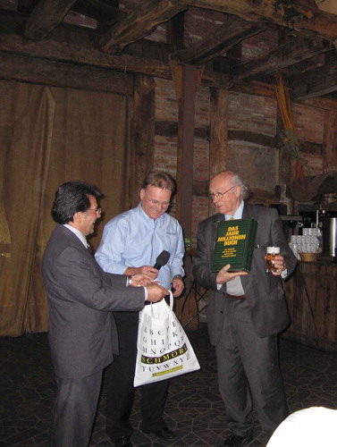
There have been so many articles written about Gottfried, scrolling through the major milestones of his professional life and listing his achievements, see, for example, Ackermann (Citation1998) and Heipke (Citation2010a), that it is hard to add anything new or less known to it. shows Gottfried when his 75th birthday was celebrated at the High-Resolution Earth Imaging for Geospatial Information, ISPRS Joint Workshop, Hannover, Germany in 2005, and now we celebrate his 75th anniversary of his professional life.
Figure 1. Celebrating Gottfried’s 75th birthday at the banquette of the Hannover workshop in 2005
The objective of this paper is to try briefly assessing the impact of Gottfried’s work and contributions to the advancement of mapping at large. However, this is a quite challenging task, as by now we got used to have instant access to almost anything in our digital world, when all the information is just a few clicks away. Well, it is not totally true if we search for a document with older time tags, as most of the hardcopy books and papers dated prior to the digital age are less accessible. These older documents may have been scanned and available for viewing, but are not necessarily ready for a text search; though, there are developments to that end. Given Gottfried’s normal career, defined as prior to his retirement in 1998, most of his papers are prehistoric to the information age, and thus less accessible. He is not in Google Scholar, at least, not at the time of writing this paper, but knowing Gottfried this could still change. Of course, many of his later papers are in the cloud (Konecny Citation2014), and finding their citation numbers is easy.
2. The golden age of photogrammetry
Airborne surveying and reconnaissance experienced major developments after WWI, but the era after WWII represented probably the most dynamic phase in the history of photogrammetry. This was the time that the discipline, long dominated by military and government, started to extend into civilian applications. Rebuilding the economies destroyed during the war provided a big market for mapping and soon after, the economic boom of the 1960s further extended the market for photogrammetry. The need for cameras and photogrammetric equipment was on the rise, and to respond to the need of professionals, new undergraduate and graduate programs were created across the globe. Gottfried’s career is closely connected to these developments. When he was at OSU, he could see the creation and rapid growth of the Geodetic Program and also became lifelong friend with Frederick Doyle, another giant of photogrammetry and ISPRS, the first chair of the Department of Geodetic Sciences at OSU. Clearly, this helped Gottfried set up the Department of Surveying Engineering at the University of New Brunswick, Canada (now Geodesy and Geomatics Engineering). Credited to his solid background and strong motivation combined with hard work, the new program gained popularity and recognition in record short time, and quickly established him as an authority in the surveying and mapping world. Remarkably, he advanced to full professor level and became the department chair in 7 years.
In the 1960s, classical surveying tools and analog photogrammetric instruments provided geospatial data for the growing community of users. The Wild RC-8 large-format aerial camera introduced in 1956 was one of the first cameras widely used for mapping; close to 400 units were sold worldwide. On the analog plotter front, the Wild A8, introduced in 1952, became the most popular workhorse, and point transfer devices were also widely used. The lack of computers back then forced both academics and industry to be creative in reducing the need for computation and also to develop sensors where sensor calibration was not too complex. Lenses of aerial cameras were perfected to have only a few microns of distortions, which could be easily managed, and in general, had very little impact on the absolute positioning accuracy, which, primarily depended only on the scale. Gottfried’s PhD was about aerial triangulation with a focus on convergent photography. Though, at defense, this topic created less interest, as nobody could predict the coming technological developments, however, this work gave Gottfried a very strong analytical foundation for his future work. Clearly, this topic was way ahead of its time, and later became an enabling tool for many applications.
With the introduction of computers, the transition from analog to analytical photogrammetry started around the time when Gottfried moved back to Germany and was appointed as Professor and Director of Institute for Photogrammetry and Engineering Surveys, University of Hannover (now Institute of Photogrammetry and GeoInformation, Leibnitz University Hannover). Compared to the analog photogrammetry era, this period was characterized by major developments and the expansion of the mapping world. In the 1980s, hundreds of analytical plotters were produced by several manufacturers with three companies providing the vast majority of the instruments. Zeiss introduced the Planicomp C1XX line, followed by the very popular P-series plotters; Wild produced the AC1, BC1 and BC2, Kern the DSR series, and after the Wild and Kern companies’ merger the SD2000/3000 instruments were in production; for more info, see (Photogrammetric plotters). In parallel, the large-format aerial cameras started to also benefit from microprocessor control, greatly extending the camera capabilities for the users. The changes in user interfaces were another major development, as operators began moving from paper to using digital data. More importantly, the introduction of computer systems was an enabling technology that advanced the computational capabilities for photogrammetric computations. For example, convergent photography or larger lens distortions could be easily handled. While compared to current standards, the processing power and storage capabilities were extremely limited, yet they allowed for an explosion in many areas, such as Aerial Triangulation (AT) being the most significant one. By the 1990s’, there were several powerful AT packages on the market, including Albany, AeroSys, Bingo, BLUH, GAPP, ISSBA, PAT-B, PAT-M, RABATS, just to name the better known cases. For the first time, blocks formed by thousands of images and measured on analytical plotters could be triangulated very accurately. Not surprisingly Gottfried’s students made significant contributions in this field as well; most notably, by creating and maintaining the Bingo and BLUH packages.
3. The birth of remote sensing from space
Gottfried, as an ambitious person, has always had a vision and could sense future trends early on. During his stay at New Brunswick, he developed close collaboration with NASA, as he already recognized the potential of the observations from space; in fact, for a while the term Space Photogrammetry was used to identify this new emerging field (Schroeder Citation2005). Not surprisingly he became involved in the Apollo program and then continued on with using mapping cameras in space. Returning to Europe, Gottfried became a champion of space observations and then, similar to Fred Doyle in the US, became the de facto authority in spaceborne remote sensing. At the University of Hannover, he educated a generation of remote sensing professionals during his nearly three decades of tenure.
While Landsat was providing global coverage by the end of the seventies, the spatial resolution was coarse compared to airborne photography, even for high-altitude surveys, and the gap between satellite imagery and existing photogrammetric practice was just too big. Gottfried proposed and lead the first civilian experiments to send a metric camera into space on the Spacelab platform (Konecny Citation1984). During the mission, about 1000 photos were acquired on black and white and color infrared film, providing unprecedented coverage of a very large part of the earth at 10–15 m resolution. Since digital sensing technology at that time was practically non-existent, the conclusion of the experiment was that analog film-based photography would have a significant role in the future, a prediction that failed fairly soon.
With rapid technological developments of the nineties, CCD linear arrays, reaching high performance became the primary imaging device for spaceborne remote sensing. The MOMS-02 camera system (Kornus, Lehner and Schroeder Citation2000; Schroeder et al. Citation2000), equipped with multiple linear sensors to produce observations in four spectral bands with multiple camera heads to allow for along-track stereo was flown the first time on Spacelab, as a dedicated German mission and then multiple times on the Russian MIR station, all coordinated by DLR. The processing of MOMS-02 imagery required an enormous effort and the involvement of all the major German universities with strong photogrammetric background, including Hannover, Munich and Stuttgart. From the four major areas, image matching, bundle block adjustment, DEMs, and stereo vector mapping, Gottfried led the development of a stereo workstation and made significant contributions to stereo point measurement.
As the European space collaboration started to grow, Gottfried was a key insider and matchmaker to fly the DLR stereo camera on SPOT missions, although the implementation had a few hurdles and the camera did not get spaceborne, but the multi-line concept prevailed when the new camera was launched in 2002 (Baudoin et al. Citation2004). By that time, the sensor performance level and platform georeferencing improved greatly, while both absolute accuracy and standard deviation were in the sub 10 m range. Furthermore, always open to new developments, Gottfried closely followed the application of radar technology; in particular, the use for InSAR for generating global DEMs.
Looking at Gottfried’s technical involvement on international level, it is characterized by his strong interest and commitment to spaceborne mapping systems, including running ISPRS WGs on “Geometry of Remote Sensing Systems”, 1972–1976, and then “Mapping from Space” 1992–1996, 1996–2000. As a service to the international mapping community, in parallel with his technical involvement, he completed a full 16-year cycle on the ISPRS Council serving as Congress Director, Secretary General, President, and 1st Vice President.
4. The era of digital photogrammetry
The transition from analytical to digital photogrammetry happened in parallel with the remote sensing from space developments, which technology, in fact, was widely considered as a predecessor of digital photogrammetric workstations. Consequently, Gottfried had a head start, as he was already involved in processing space imagery on digital workstations and could apply his expertise to the fledging domain of digital topographic mapping. He was closely involved in the softcopy system developments, Context Mapper was developed in Hannover, and then his earlier contributions to space cameras provided valuable knowledge to advance the airborne digital camera evolution, which was completed by the beginning of the third Millennium. On the education side, he was an early promoter of digital technology, and as an emeritus faculty lectured to promote digital photogrammetry and related mapping applications for about two decades all over the world.
5. The citizen of the Earth
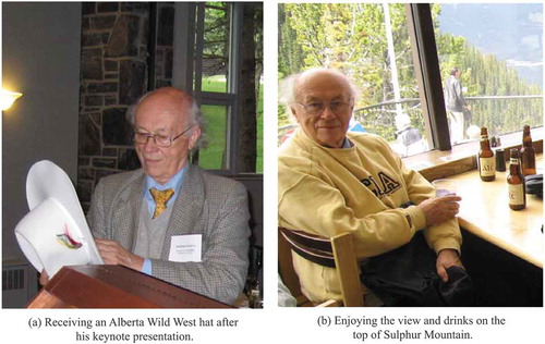
The digital age completely transformed the geospatial industry and practice, by creating an entirely digital workflow, including data acquisition, processing and dissemination and significantly reducing delivery times. Furthermore, in many cases, no actual data transfer happens, as the processed data is uploaded and then resides in the cloud and accessed on an as-needed basis. In the past decade, crowdsourcing has become a significant source of geospatial data (Heipke Citation2010b), and to keep up with increasingly growing amounts of data, Data Analytics, mainly Big Data and Deep Learning provide the necessary technologies for highly automated data processing and information extraction. This is totally different from the surveying and mapping practice of the era when Gottfried received his formal training and spent most of his active years at universities. Yet, when the time came, he was ready to learn and master new technologies. As a popular keynote speaker, he was and still is invited to countless events, and his slides are continuously updated and reflecting on the general state-of-the-art with a special focus on the needs of national mapping agencies. shows a few moments of Gottfried who was the keynote speaker at IPSRS WG I/2 Workshop on 3D Mapping from InSAR and LiDAR, Banff, Alberta, Canada, 2005.
Figure 2. Keynote speaker at ISPRS Banff workshop
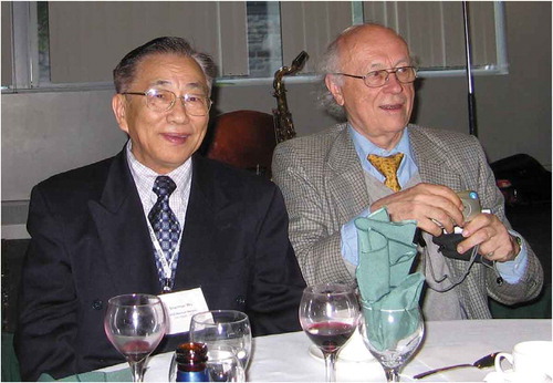
The rise of network and communication capabilities and their affordability has led to rapid growth and acceptance of social networks, making our geographic locations in social sense nearly irrelevant, as only the time for some coordination may be required. Obviously, there is no substitute for personal meetings, yet studies show that social media has brought people closer to each other. The voice and video communication are quickly migrating to network based, and more than one-third of the earth’s population has been using smart devices, connecting them all the time, including Gottfried who mastered smartphones rather quickly. Furthermore, it did not take a long time for him to create Facebook and LinkedIn accounts. Pretty soon, Facebook became the record of Gottfried’s most recent activities, documenting mainly those with whom he has had professional links. He still frequently posts and shares his photos and topics of interest to him; shows Gottfried with his camera that he always carries with him. Not surprisingly, you will not find people from his early career, as either they are gone or not as active as Gottfried. However, there are many next-generation professionals among his Facebook friends, and a comparable pool of young, early-career professionals, clearly showing his devotion to mentoring the next generation as well as his appeal to young people. This social media presence substitutes for the classical Gottfried social involvement at conferences, where he typically showed up with his legendary cigars for the evening program, first dining with his peers, and then continuing with the students to enjoy late night live jazz.
Figure 3. Gottfried with Sherman Wu, another famous photogrammetrist involved in deep space mapping, holding his indispensable point & shoot camera that he always carries with him to take pictures at presentations and social events
The Erdos number (Erdos) is a gold standard in the mathematics community to measure performance with respect to one of the most significant mathematicians of the twentieth century. Obviously, the mapping community is significantly smaller in size, yet Gottfried would be an excellent candidate to create a similar measure, as during his 75 years of professional engagement, he has met and most likely collaborated with the largest number of people in the photogrammetric and remote sensing field. From his close to 50 doctoral students, many of whom stayed in academia and mentored another generation of mapping professionals, and also closely related to Gottfried; as a Erdos number analogy, they would have a Gottfried number of 2.
After formally retiring from Hannover, Gottfried’s professional life shifted to service. Giving workshops, trainings in developing and third world countries expanded Gottfried’s research interest and clearly represented Gottfried’s desire to contribute to the well-being, the better life of all people on this planet. By educating a new generation of professionals, on topics such as the transition from traditional photogrammetric to cartographic products to full 3D visualization, he helped to form strong communities and leaders across the mapping world. In the past two decades especially, Gottfried has clearly focused on these efforts and volunteered almost all his time to work for various NGO organizations involved in supporting Sustainable Development Goals (SDG) developed by the UN. The most important is probably his recent involvement in UN GGIM (Konecny, Breitkopf, and Radtke Citation2016); until a few years ago he represented ISPRS at the annual meetings at UN Headquarters in New York City.
6. Conclusions
Gottfried is one of the few people who have been fortunate to experience the three major periods of photogrammetry, and, to various extents, contributed to the development and application of all the three technologies. His career started when analog photogrammetry was the golden standard for mapping. With the introduction of computer technologies, analytical photogrammetry quickly redefined the mapping landscape for about two decades before the third Millennium. The arrival of the Internet as well as the rapidly advancing sensor and computer technologies heralded the age of digital photogrammetry, which provides totally digital mapping capabilities, including cloud-based processing.
Gottfried has been also fortunate to meet and interact with generations of geospatial professionals. As an educator, he has mentored a cadre of highly skilled and successful professionals, which is a testament on its own. He is a very social and approachable person, and people seek his company to learn from him, have a great conversation with him or just enjoy his warm and supportive personality. In the name of our mapping community, I wish him many more years in good health and continuing professional engagement.
Disclosure statement
No potential conflict of interest was reported by the author.
Data availability statement
There is no data related to this work.
Additional information
Notes on contributors
Charles K. Toth
Charles Toth is a research professor in the Dept. of Civil, Environmental and Geodetic Engineering, The Ohio State University. He received a M.Sc. in Electrical Engineering and a PhD in Electrical Engineering and Geo-Information Sciences from the Technical University of Budapest, Hungary. His research interests and expertise cover broad areas of spatial information sciences and systems, including airborne photogrammetry and computer vision, navigation and georeferencing, multi-sensor geospatial data acquisition systems, such as GNSS/IMU and other sensor integration for navigation in GNSS-challenged environments, sensors and algorithms for indoor and personal navigation, image-based navigation using Artificial Intelligence (AI) methods, and UAS and mobile mapping technologies for outdoor/indoor applications.
References
- Ackermann, F. 1998. “Gottfried Konecny – 40 Year of Dedication to Photogrammetry and Remote Sensing.” In edited by F. Emeritierung and G. Konecny, 13–24. Hannover, Germany: Wiss. Arbeiten Fachrichtung Vermessungswesen Univ. Hannover No. 227.
- Baudoin, A., M. Schroeder, C. Valorge, M. Bernard, and V. Rudowski. 2004. “The HRS-SAP Initiative: A Scientific Assessment of the High Resolution Stereoscopic Instrument on Board of SPOT-5 by ISPRS Investigators.” International Archives of Photogrammetry, Remote Sensing and Spatial Information Sciences 35 (Part B1): 372–377.
- Erdos: https://en.wikipedia.org/wiki/Erd%C5%91s_number
- Heipke, C. 2010a. “Gottfried Konecny – 80 Jahre jung.” Photogrammetrie Fernerkundung Geoinformation 2010: 499–500.
- Heipke, C. 2010b. “Crowdsourcing Geospatial Data.” ISPRS Journal of Photogrammetry and Remote Sensing 65 (6): 550–557. doi:10.1016/j.isprsjprs.2010.06.005.
- Konecny, G. 1984. “The Photogrammetric Camera Experiment on Spacelab 1.” In ESA EARSeL/ESA Symp. On Integrative Approaches in Remote Sensing, 243–250 (SEE N 85–14202 05-43). Noordwijk, The Netherlands.
- Konecny, G. 2014. Geoinformation: Remote Sensing, Photogrammetry and Geographic Information Systems. Boca Raton, FL: CRC Press.
- Konecny, G., U. Breitkopf, and A. Radtke. 2016. “The Status of Topographic Mapping in the World – A UNGGIM-ISPRS Project 2012–2015.” ZfV 141 (1): 20–26.
- Kornus, W. M., Lehner. and M. Schroeder. 2000. “Geometric In-flight Calibration of the Stereoscopic Line-CCD Scanner MOMS-2P.” ISPRS Journal of Photogrammetry & Remote Sensing 55 (1): 59–71.
- Photogrammetric Plotters: http://wild-heerbrugg.com/photogrammetry1.htm
- Schroeder, M. 2005. “25 Years Space Photogrammetry in Germany - a Research Field Initiated by Gottfried Konecny.” Photogrammetrie Fernerkundung Geoinformation 6: 467–476.
- Schroeder, M., W. Kornus, M. Lehner, R. Müller, P. Reinartz, and P. Seige. 2000. “MOMS-the First along Track Stereo Camera in Space-a Mission Review.” Proceedings of ASPRS Annual Meeting 400. https://elib.dlr.de/7819/