
ABSTRACT
Remote sensing mapping is an important research direction in the development of geographic surveying and mapping. In order to successfully implement the project of Mapping Western China (MWC), a technical mapping system has been established. In this project, many problems have been solved through technological innovation, such as block adjustment with scarce control points, large-scale aerial/satellite image mapping, and intelligent interpretation of multi-source images. Several softwares were developed, e.g. PixelGrid for aerial/satellite image mapping in a large area, FeatureStation for the integration of multi-source data in the complex terrain areas, and an airborne multi-band and multi-polarization interferometric data acquisition system for SAR mapping. For the first time, full coverage of 1: 50,000 topographic data of China’s land territory has been produced, which means the geospatial framework of digital China is basically completed. With the implementation of other key national plans and projects (i.e. national geographic conditions monitoring and national remote sensing mapping), the focus has changed from MWC to national dynamic mapping. Accordingly, a dynamic mapping system is established. The data acquisition capability has developed from a single source to multiple sources and multiple modalities. The mapping capability has developed into dynamic mapping, and the capability for database update shows the characteristics of collaboration. The national geographic condition monitoring creates a multi-scale index system for statistical analysis for various needs. A multi-level and multi-dimensional technical system for statistical computing and decision-making service is developed for the transformation from dynamic monitoring to information service. In this paper, we give a brief introduction about the recent development of remote sensing mapping in China with respect to data acquisition, map production, and information service. The purpose of this paper is to motivate the establishment of theory and method for remote sensing mapping, technical and equipment in the smart mapping era, to improve the capability of perceiving, analyzing, mining, and applying geographic data, and to promote the intelligent development of geographic surveying and mapping.
1. Introduction
Topographic datasets have a fundamental role in national socioeconomic development. In China, however, the topographic map at the scale of 1:50,000 was still unavailable in its western region until the early 2000s, due to the complicated natural conditions and practical technique challenges, including Tarim Basin, Qinghai-Tibet Plateau, Hengduan Mountains, etc. Meanwhile, the resolution of mapping products in these areas from other sources do not meet the requirement of the 1:50,000 topographic map. For example, the Digital Elevation Model (DEM) from AW3D30 (ALOS Global Digital Surface Model,ALOS World 3D – 30 m) provides a lower resolution.
Such a huge area without maps at the scale of 1:50,000 imposed serious restrictions on the national sustainable development. In 2005, China launched the project of “Mapping Western China for 1: 50,000 Topographic Map” with the implementation of high-resolution image mapping, topographic map production, quality control and inspection, etc. It took five years to complete the project, in which more than 2 million square kilometers of territory in western China were mapped, and a basic geographic information database at the scale 1:50,000 was built. Meanwhile, the project also established the national mapping technical system, as well as realized regular monitoring and updating system of geographic information in western China (Zhang, Yan, and Xie Citation2012a). For the first time, full coverage of topographic data at the scale of 1:50,000 and at the resolution of 12.5 m in the whole country was achieved, which indicated the establishment of the digital China geospatial framework.
With the new technical development, such as big data and artificial intelligence, the focus has changed from the mapping of western China at a particular point of time to a dynamic mapping of the whole country. In 2013, the project of “First National Geographical Condition Census” was initiated. It aims to establish a national survey and monitoring system in three years, and to support the completion of the first national geographic census and its regular updates afterward. The outcome of this project includes the detailed landscape of the whole country including forest, grassland, lake, and other geographical elements. It also ensures further regularly monitoring of the national geographic conditions. Furthermore, it promotes the transformation from dynamic monitoring to information service, and provides a decision-making basis for the implementation of national ecological civilization, land and spatial planning, natural resources supervision.
This paper first summarizes the three major innovative technologies of MWC, then analyzes the development from MWC to national dynamic monitoring, and presents the technological progress from dynamic monitoring to information services, and finally shows the prospects for the future development of remote sensing mapping.
2. The establishment of the mapping technical system in western China
The topography of western China is extremely complicated. The region is well known as the “forbidden zone of life,” “sea of death,” and “roof of the world.” Over 90% of this area are mountains and deserts, and approximately 60% are above 5000 meters’ sea level. The oxygen density in the western mountainous area is only approximately 60% comparing to the normal condition, and natural disasters occur frequently. Transportation and communication are extremely difficult in this region, while only a quarter of the area is accessible by highway.
Mapping western China is acknowledged as an extremely challenging task in the history of surveying and mapping in China. The difficulty lies in three aspects: (1) how to conduct field survey in complex terrain areas; (2) how to achieve high accuracy stereo mapping with satellite images in a large area; and (3) how to map inaccessible areas without field surveys. Especially, the complicated terrain introduces significant challenges in the field survey. More than 100 people were injured and 42 people gave their precious lives in the project of 1:100,000 topographic mapping in western China in the 1960s. To overcome these difficulties, we established a national mapping technical system ensuring the completion of the national mapping project in western China, including a series of key technologies, a new mapping platform for production and operation, new technical standards in the surveying and mapping industry, and the new national geographic information service. The coverage map of the MWC project and mapping production are shown in .
Figure 1. The coverage map of MWC project (red gird)
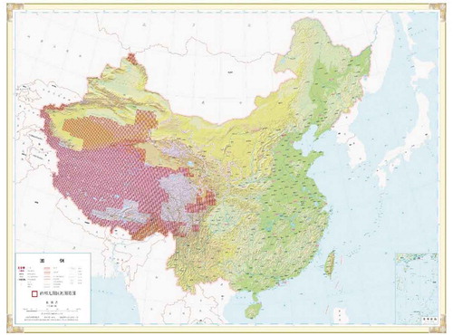
Figure 2. Mapping production
2.1. Block adjustment with scarce control points
Block adjustment with scarce control points is the most challenging problem in the MWC project. Geometric positioning models are the basic model of satellite image mapping, mainly based on rigorous models. Satellite images mostly provide precise ephemeris and attitude. The geometric model adopts different orbit fittings, such as the Gupta model (Gupta and Hartley Citation1997) that uses a straight orbit, and the Westin model that uses a circular orbit to process SPOT images (Westin Citation2001). The application of the Rational Function Model (RFM) has not been largely applied around 2005 (Dial and Grodecki Citation2002). In such circumstance, the autonomous positioning and block adjustment with scarce control points for large-scale optical remote sensing images was proposed for the MWC project. Only one ground control point (or a group of several nearby control points) is needed for stereoscopic satellite images covering 5600 ~ 8000 km2. Ninety percent of field workload can thus be reduced. The key technical points include:
Developing a general sensor physical model for multi-source images in the geocentric coordinate system. A CCD multi-linear array image orbit model was developed based on differential GPS, Inertial Measurement Unit (IMU), aerial and satellite sensor combined system. And the error law of positioning after compensation of internal and external azimuth elements of remote sensing images was revealed. Large-scale aerial imagery mapping can be easily affected by earth curvature when satellite images and aerial images are combined processed in a local coordinate system. The limitation of earth curvature on accurate geometric positioning of large-scale remote sensing images was broken through, and a strict aerial triangulation model for large-scale remote sensing images was realized.
Applying the Rational Function Model to the integrated processing of geometric positioning for multi-source remote sensing images. The RFM steady-state estimation technology was developed, and the method for image block adjustment with few or no ground control points in a large area was firstly accomplished. It needs only one ground control point (or group of nearby points) for 14–20 topographic maps of 1:50,000 scale. By using the common adjustment method, it needs at least one ground control point for each topographic map (Zhang et al. Citation2009). Moreover, the rigorous model is used for combined processing with satellite images and aerial images, while RFM is only used for satellite images.
The technologies of high-precision autonomous positioning for satellite images (e.g. SPOT-5) are realized. Due to the difficulty of control point measurement in inaccessible areas, aerial strip images with high-precision POS (positioning and orientation system), and high-resolution satellite images (such as IKONOS) are used for high-precision autonomous positioning of satellite images. By using this method, the map of 910,000 km2 in Qinghai-Tibet Plateau has been produced, and the accuracy meets the 1:50,000 mapping requirement.
2.2. Aerial/satellite image mapping in large area
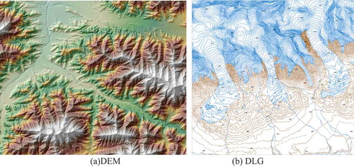
There are many Digital Photogrammetry Workstations (DPW) that can be used for image mapping, such as Pixel Factory, SoftPlotter, ImageStation, etc. Among them, Pixel Factory is a world-class remote sensing image automation processing system, and it has the characters of automation, parallel processing, multiple image compatibility, and remote management. However, Digital Surface Models (DSM)/Digital Elevation Models (DEM) automatically generated by Pixel Factory may have local errors especially in complex terrain area (Frank Citation2003). To overcome the technical problem of high-precision stereo mapping in a large area, an integrated mapping software named PixelGrid has been developed. Its monthly production capacity of DEM and Digital Orthophoto Map (DOM) with one person, single workstation, and single computing node has reached 400,000–600,000 km2. It opens the era of mass production of a high-precision stereo map of satellite images. The key points are concluded as follows:
The universal multi-angle and multi-view image matching model and the high-precision DEM/DSM automatic extraction method based on multi-baseline and multi-matching features are proposed for the MWC project. To solve the problem of automatic extraction of DEM/DSM in complex terrain areas, the DEM/DSM adaptive filtering technique was developed based on the terrain slope, height difference analysis. It can automatically extract DEM/DSM in the hilly and mountainous areas, reduce 20%–40% amount of the work for data collection in the office, and improves the reliability and accuracy of automatic extraction of 3D terrain information from images (Waser et al. Citation2008; Zhang and Zhang Citation2008). Image matching should meet the technical requirements of high-resolution image mapping, topographic map production, quality control and inspection, etc. It also needs editing after automatic matching. Recently, classic dense matching technology is constantly being developed and improved, and deep learning is also integrated into the field of image matching. For example, using CNN (Convolutional Neural Networks) to learn the stereo matching process to realize automatic matching (Zbontar and LeCun Citation2015). Deep learning and classic matching technology are combined to improve the quality of matching (Seki and Pollefeys Citation2017).
A high-precision, multi-baseline image registration method is proposed based on the scale/rotation invariant feature. Regarding to the difficulty of ensuring accurate and reliable image registration with large inclination, rotation angle, and resolution variance, an automatic registration method was developed for large-angle inclined images and wide baseline remote sensing images. We developed a method for fast construction of an image point network without POS data and a matching technology based on object constraints with POS data. The dense matching results were manually checked and edited according to quality inspection standards to obtain the correct DSM in a three-dimensional environment.
The technology for accurate positioning and correction of remote sensing images without control points has been developed. A method of automatically, accurately image registration for the aerial image, high-resolution satellite image, and public geographic information or existing DOM/DEM was developed around 2005. An automatic extraction of control points in the block adjustment process of aerial image and high-resolution satellite image was developed. Finally, the rapid and accurate positioning of large-scale high-resolution remote sensing images and high-efficiency and high-precision map production were achieved.
Distributed parallel computing of multi-core CPU/GPU clusters based on loose coupling parallel service middleware was realized. A series of algorithms for distributed high-performance CPU/GPU cluster processing for multi-source remote sensing data were developed in a high-speed network environment using several to dozens of computers. It realized the functions of automatic aerial and satellite images matching, DEM automatic matching, fast (quasi-real-time) orthorectification and seamless splicing, and improved the automatic processing ability of massive remote sensing data (Yang, Zhang, and Huang Citation2014).
2.3. Intelligent interpretation of multi-source images in western China
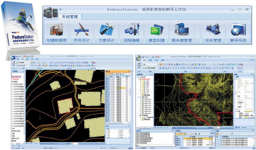
We proposed a multi-source remote sensing image interpretation method and processing flow, and developed an intelligent interpretation workstation “FeatureStation” for multi-source data in the complex terrain areas in western China. The interface of “FeatureStation” is presented in . An integrated working mode of network distributed collaboration for “data collection-edition-quality inspection” was created. It meets the needs of rapid production requirements of 1:500–1:100,000 scale Digital Line Graphic (DLG) and land-cover map. Additionally, it solves the problem of field mapping in areas where field crew are not accessible, and realizes the upgrading and transformation of the traditional mapping process. The key points are concluded as follows:
An object-oriented, multi-scale segmentation and classification method has been developed. A multi-scale segmentation algorithm based on the principle of regional growth and minimum heterogeneity was proposed for the automatic segmentation of high-resolution remote sensing images. Using object-based classification methods, such as support vector machine, decision tree and fuzzy rules, and adopting spatial cognitive reasoning and classification strategy, the object-based classification based on cognitive computing can be achieved (Li et al. Citation2008, Citation2010; Gu et al. Citation2017, Citation2018). Recently, deep learning segmentation networks, e.g. Fully Convolutional Networks (FCN), Pyramid Scene Parsing Network (PSPNet) and U-Net, have been recognized as promising tools in high-resolution remote sensing image classification, and achieved great attentions (Ball, Anderson, and Chan Citation2017; Maggiori, Richard, and Charpiat Citation2016,, Kemker, Salvaggio, and Kanan Citation2018).
An automatic tracking and extracting method for graded and nongraded roads was proposed. Aiming at the graded road, the least square template (i.e. “T” shape, “+” shape) matching strategy was developed for the rapid tracking and extraction of road. For non-grade roads, two methods were proposed, i.e. road tracking based on least square circular template matching, and road tracking based on support vector data description (SVDD) and distance transformation integration, to achieve accurate, efficient, and robust tracking of nongraded roads (Lin et al. Citation2011; Lin, Shen, and Liang Citation2012; Zhang et al. Citation2011).
A common computing model for parallel processing of remote sensing data was established (Yang, Zhang, and Huang Citation2014). For the processing of large-scale remote sensing data, a common computing model suitable for parallel processing of massive remote sensing data was developed using four strategies of disassembling tasks, data, functions, and algorithms. It can be used for complex algorithms and different tasks, and its processing speed was improved by more than five times compared with similar interpretation software.
An integrated solution of all-factor interpretation based on network mapping was established. Several strategies (e.g. integrated data collection and edition in plane/three-dimensional mode, collaborative work in a distributed network, intelligent processing, multi-layer spatial database storage, etc.) were combined to achieve an integrated solution of remote sensing interpretation.
Figure 3. Interface of the intelligent interpretation workstation “FeatureStation”
3. Establishment of national dynamic mapping system from mapping in western China to national dynamic monitoring
The national dynamic mapping shows the characteristics of wide geographical coverage, a large amount of data, abundant information, fast mapping speed, and a long time series. The mapping extent has expanded from the west part of China to the whole country. The mapping scope has expanded from the basic mapping to the monitoring of geographical conditions, which means the mapping elements have developed from earth surface to three-dimensional space, and the mapping has changed from a particular point of time to continuous monitoring. The data acquisition capability has developed from a single source to multi-sources and multiple modalities. The mapping capability has changed from a single map to dynamic mapping, and the database should be able to update in a collaborative way.
3.1. Data acquisition capability: from a single source to multi-sources and multiple modalities
Several projects, such as a high-resolution earth observation system, space-earth integration network, UAV (Unmanned Aerial Vehicle) networking, have been implemented for supporting the national strategic plans, e.g. “Land and Sea Observation Satellite Development Plan (2011–2020),” “National Civil Space Infrastructure Mid Long Term Development Plan (2015–2025),” etc. China has launched a series of satellites, such as China-brazil earth resource satellite (CBERS), Gaofen satellite (GF), Resources satellite (ZY), Environment satellite (HJ), Mapping satellite (TH), SuperView satellite (GJ), and established aviation platforms, such as UAV and unmanned airships. Developing from medium and low resolution to high resolution, from the single optical sensor to multi-sensors, China is able to provide stable multi-temporal data for national and global mapping.
3.1.1. Space, aerial, and ground platform
Remote sensing is the main means of data acquisition for the national geographic condition census and the resources of global geographic information. It can repeatedly and quickly obtain national, even global images. China has launched 26 earth observation satellites by far, forming multiple sensors (e.g. ZY-3 satellite is equipped with three-line array cameras, multispectral cameras, and laser altimetry sensors, see ), high-resolution (e.g. the panchromatic resolution of the GJ-1 satellite image is 0.5 meter), and multi-view earth observation system.
Aerial photography is an important technical means to obtain data rapidly, as it is not restricted by ground conditions, short in the survey period, high in mapping accuracy, and convenient in data recovery. Low-altitude UAV has the ability to fly at low altitude under clouds, effectively avoiding interference from clouds and weather, which compensates for the shortcomings of optical remote sensing satellite and ordinary aerial photography that are easily affected by cloud occlusion. Therefore, it would be an effective means to quickly obtain high-resolution images where the weather condition is suitable for optical satellite. Additionally, it has the advantages of high time efficiency, low cost, low loss, low risk, and repeatability. The aerial photography system in China is characterized by multi-sensor, high resolution, miniaturization, etc. By using multiple sensors, such as multi-view tilt camera, panorama camera, video camera, Lidar, it can obtain surface 3D information and high-quality texture information.
Ground mobile mapping is also an important means to achieve refined data. It can provide high-precision data for virtual China, smart cities, and automatic driving. Using a variety of advanced sensors (e.g. panorama camera, video camera, laser radar, etc.) carried by a mobile car, the spatial position data and attribute data of the road and the ground objects on both sides of the road can be quickly collected. It has the characteristics of fast data acquisition and rich scene targets.
With the development of spatial information technology, open-source geographic data have become an important supplement to spatial data sources, providing reference data for remote sensing mapping. Open-source data can be divided into two categories: geographic information products and multi-source geographic data. Geographic information products are public products produced by the government, scientific research institutions, and other departments, such as AW3D30, USGS (United States Geological Survey) land cover data, global land use data, etc. It is normally of high practicability, rich information, and reliable quality. Multi-source geographic data are obtained by many nonprofessionals volunteers and provided to the public or related institutions via the Internet, such as OSM (Open Street Map). It has the characteristics of large data volume, highly automatic operation, abundant information, low cost, and immeasurable quality.
Table 1. Sensor information of ZY-3
3.1.2. Full coverage
For the whole country of China, medium- and low-resolution images can be obtained every two days; for each province, 2 m resolution images can be obtained quarterly; for the key area in a province, 0.5 m resolution images can be obtained according to a specific date. High-resolution observation satellites used for mapping mainly include GF-1, GF-2, GJ-1, etc. Details see .
Table 2. Sensor information of GF and GJ
3.2. Dynamic mapping ability
China has launched several projects such as national geographic condition monitoring, global land cover mapping, and object-oriented SAR processing system with high reliability. We have solved the technical problems of high-precision interpretation of remote sensing images and high-reliability SAR processing, developed mapping software and hardware equipment, formed the large-scale dynamic mapping capability, and realized the transformation from mapping western China to dynamic mapping.
3.2.1. Image interpretation
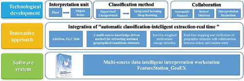
Remote sensing image interpretation has gone through the stages of manual interpretation and semi-automatic interpretation. It is now developing toward automation and intelligence with the ever-changing requirements of remote sensing application, the launch of high-resolution remote sensing satellites, the development of artificial intelligence, the accumulation of geographical knowledge, and the application of historical accumulated data. From the perspective of image interpretation unit, it develops from pixel level to object level and scene level; from the perspective of classification methods, it develops from supervised and unsupervised classification to integrated learning and deep learning classification; from the perspective of a collaborative approach, it develops to collaboration between automatic and manual work, a collaboration between interpretation and quality inspection, collaboration between office and field work ().
We developed a compound decision tree algorithm named ADATree which is suitable for the classification of satellite remote sensing images with different resolutions, and a general remote sensing classification system named GLC_Info which is applicable for pixel-level and object-level classification. It is capable of automatic generation of training sets based on samples, automatic generation of rule sets from training sets, and automatic adjustment according to thresholds. Because of its versatility, it is helpful to overcome the problem of manually establishing complex rule sets. Considering the quality, time phase, complexity, and fragmentation of high-resolution remote sensing images, the classification rule set for first-level classes of national geographic condition monitoring can be automatically derived under the guidance of expert knowledge. The overall classification accuracy (for farmland, orchard, woodland, grassland, building, road, bare land, and water) is better than 85%.
A multi-source, knowledge-driven method for extracting national geographical condition elements has been proposed, such as roads, water bodies, and buildings. With the support of topography, land use, water conservancy, transportation, basic geographic information, and other databases, the national geographic condition elements can be intelligently extracted by the knowledge-driven method and transformed into knowledge (Lin, Shen, and Liang Citation2012; Lin et al. Citation2011).
An object-based, iterative weighted method for multivariate change detection (IR-MAD) has been proposed. It uses object-based segments as input variables to obtain object-based IR-MAD change results instead of image pixels, improves the consistency of changing patches, effectively reduces the influence of background information on change information, and achieves intelligent extraction of change information of the national geographical condition elements.
The collaboration between office and field real-time mapping and verification of geographic elements has been realized. We designed a task-oriented operation mode for office and field work collaboration, and proposed an integrated operation mode for extracting, editing, calibrating and sorting, and updating geographic elements. The accurate discovery of change information from office work was achieved. Additionally, we proposed a mobile real-time operation mode to ensure the accuracy and reality of the change information based on on-site monitoring information. It has completely changed the collaboration mode of the office and field work, and the verification efficiency increased largely.
We developed the first advanced software system for extracting and interpreting national geographic condition elements in developing countries. It can be used for large-scale and full coverage extraction of national geographic condition elements. The data accuracy and overall reliability reached 99% after interpretation, manual adaptation, field verification, and modification. The problem of fine extraction of national geographic condition information has been solved (Zhang et al. Citation2016).
Figure 4. Development of mapping ability for national dynamic mapping
3.2.2. SAR Mapping
The high-precision SAR mapping is a beneficial supplement to optics image mapping. It is suitable for areas covered by cloud, fog, and snow, where it is difficult to obtain optical images. The main techniques are concluded as follows (see ):
A mapping model of SAR image with few control points was established. Using the sensor position and attitude as orientation parameters, a side-looking radar remote sensing image distance-coplanar equation was constructed. And the joint adjustment of side-looking radar image and POS (GPS+IMU) data or orbit attitude data was realized (Cheng et al. Citation2013; Cheng et al. Citation2017). The number of field control points needed for mapping is reduced by 90%, and the number of flights in the same survey area is reduced by 40%, which meets the needs of aerial triangulation for 1:5000–1:50,000 scale mapping.
A three-dimensional information extraction method integrating stereo and InSAR, orbit-raising, and orbit-lowering data fusion was proposed (Huang et al. Citation2008). Two different stereo pairs (one pair of orbit-raising and orbit-lowering) were fused to extract DEM, respectively, solving the problem of missing terrain information in the overlaid area. And interferometric SAR and stereo SAR were fused to obtain high-precision DEM with complementary advantages (Huang et al. Citation2008).
The knowledge-based and object-based high-confidence interpretation of SAR ground object was achieved (Zhang, Huang, and Cheng Citation2018). The knowledge-based methods for point, line, and surface ground object interpretation were developed to solve the problem of lack of target recognition types and low credibility for SAR image interpretation. The overall accuracy of SAR interpretation has been improved by more than 15% (Lu et al. Citation2015).
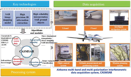
A SAR workstation for mapping in complex terrain area was developed. It is the only SAR data processing and analysis system that can comprehensively use polarization, interference, and stereo SAR technology for mapping and interpretation in China. It can be used for producing DLG, DEM, and DOM with a scale of 1:5000~1:50,000 (Zhang, Huang, and Cheng Citation2018). The usability is comparable to well-known software, such as GAMMA, Earthview InSAR.
An airborne multi-band and multi-polarization interferometric data acquisition system (CASMSAR) for SAR mapping was developed (Zhang et al. Citation2012b). From the traditional single data acquisition mode to the integrated data acquisition mode of multi-band (X and P bands), multi-polarization (HH, HV, VH, and VV), and dual-antenna interference, CASMSAR has the ability to acquire polarization and interferometric SAR data with different resolutions of 0.5 meters, 1 meter, 2.5 meters, and 5 meters from an altitude of 10,000 meters above sea level. It is the only domestic SAR system that meets the requirements of 1:5000–1:50,000 scale mapping under various weather conditions, e.g. in day, night, rain, cloud, and fog. In terms of performance, the interference antenna has developed from needing a stable platform to without a stable platform, and the baseline length has increased from 0.5 to 2.2 meters, and the elevation accuracy has increased by four times. It is the first airborne SAR system in China that integrates multi-band, multi-polarization, and interference functions for mapping, and its overall performance has reached the international advanced level of the same kind.
Figure 5. SAR mapping system
3.3. Database updating in a collaborative way
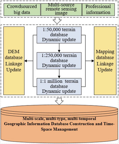
The MWC project has achieved full coverage of China’s 1:50,000 topographic data and formed a national base map. The project of national geographic condition census has obtained massive geographic data composed of 260 million image parcels of three classification levels (including 10 main classes, 58 sub-classes, 135 third-level classes). It established a new generation of national basic geographic information database with multi-temporal integration, multi-scale collaboration, and graph-number linkage. China’s 1:50,000 terrain data have been upgraded from every five years to every year, realizing the linkage update of multiple geographic information (Chen et al. Citation2010) ().
The rapid and dynamic updating approach combining big data with remote sensing images was created. It has greatly shortened the updating cycle of the 1:50,000 topographic database from five years to one year. A change detection method based on internet big data mining was developed. Using internet information, online maps, public data, etc., the change clues of geographic information can be found actively and quickly through the establishment of data mining rules, information search, web crawling, structured entry, filtering, duplication removal, plotting, and publishing. Every year, nearly 10,000 pieces of effective updated information are collected, mainly for changes in traffic, place names, pipelines, etc. Furthermore, the incremental updating technology based on the identification of database element was developed for incremental acquisition and editing, quality inspection, reconciliation, and storage through engineering approaches. It has doubled the operating efficiency and supported the dynamic updating of the 1: 50,000 database.
The approach of cross-scale geographic information updating was developed for collaborative updating of national topographic databases of scale 1:10,000, 1:250,000, and 1:1000,000. A cross-scale update model was designed to achieve coordination and unification between the scale of 1:10,000, 1:250,000, , and the scale of 1:50,000. The automatic matching rules and algorithms for cross-scale elements were designed to realize the automatic association of elements with the same name at different scales. An integration method of intelligent linkage for incremental elements was developed to support the update of 1:250,000 and 1:1000,000 databases.
The approach of incremental linkage updating cartographic and topographic data has been developed for the coordinated update of the national cartographic database of various scales. The linkage updating model was designed to realize the integrated storage and correlation between cartographic and topographic data. We designed a set of rules for map expression based on the topographic database and developed a linkage updating method based on incremental elements of the topographic database for supporting the annual update of the national cartographic database of various scales.
The approach for building a multi-temporal incremental database at the element level and spatial-temporal management has been developed for the new generation of national basic geographic information database with multi-temporal integration, multi-scale cooperation, and graph-number linkage. A multi-temporal database model based on incremental elements was designed for element-level objects association with the same name under different tenses, incremental storage of historical databases, and time-series statistics of multi-temporal elements. The method for building a check-in upgrade database based on incremental identification was developed. Differing from the traditional splicing database, it completes the new database by upgrading the old database, thus improves the efficiency of database building and greatly reduces the storage redundancy. Furthermore, a spatial-temporal management approach of multi-temporal elements was developed for the change detection, statistical analysis, and historical backtracking under different tenses.
Figure 6. Workflow of database linkage update
4. From dynamic monitoring to information service: the establishment of a technical system for information services based on national geographic condition monitoring
To extract geographic information from the raw data requires the comprehensive use of quantitative statistics, spatial analysis, and other specific models to extract rules and internal knowledge of the spatial structure, spatial distribution, and spatial relationships of various geographic elements according to the goals of national decision-making and management. Several technic problems need to be solved to achieve the transformation from geographic data to geographic information and further to the geographic knowledge, e.g. computing efficiency, integrated analysis of geographic data, etc. (Zhang et al. Citation2016). Such information can be shared with central or local governments for decision-making, or supplied to institutions or universities who applied for scientific researches. National platform for common geospatial information services can be accessed all over the world (https://www.tianditu.gov.cn/).
A multi-level index system for statistical analysis of geographical conditions for multi-demand applications was created. A semantic model for transforming from geographic condition data to the index system was proposed to solve the problem of insufficient adaptability of traditional statistical methods to the statistical analysis of geographical conditions. This index system covers five topics: resource distribution and utilization, landscape pattern, equalization of basic public services, regional economic potential, and urban development, which reflect the spatial distribution and its development of various elements regarding to the aspects of resources, environment, ecology, etc.
A multi-level and multi-dimensional statistical system and a decision-making service mode were established for accurate modeling of the three-dimensional spatial surface using geographical condition elements, efficient statistical calculation, and cross-checking of statistical results using multiple geographical units. For the first time in China, the transformation from geographic data to geographic condition information has been systematically achieved nationwide.
The technical problems of data-intensive and computation-intensive parallel statistical analysis were solved for mass data. The integration of accurate modeling and efficient statistical calculation in an intensive computing environment was achieved (Kang and Lin Citation2014; Kang et al. Citation2018). Different methods and models were proposed, e.g. distributed spatial index, intensive memory mapping mode, approximate real-time statistics supported by the vector pyramid, high-speed slice rendering of high-resolution vector spatial data, multi-temporal land cover data information transfer, model of computing dependencies based on the space division, asynchronous dynamic scheduling supported by the thread pool, and statistical algorithm model management based on reflection mechanism. The multi-process parallel computing method was adopted for balanced division of large-scale and massive patch patterns and parallel driving of thread subtasks. A key technical framework that supports the adaptive parallel optimization of many statistical analysis operators and an asynchronous streaming computing engine that supports asynchronous parallel scheduling and efficient analysis and calculation of geographic big data have been developed.
5. Summary
Remote sensing mapping is an important means to produce topographic data. Through technological innovation, challenges, such as the regional network adjustment based on rare control points, large-scale aerial satellite image mapping, intelligent interpretation of multi-source images, can be solved. A technical system for mapping the western part of the country is established to ensure the completion of the mapping project. For the first time, the full coverage of the 1:50,000 topographic map of China’s land territory has been achieved.
With the release and implementation of the national plans and projects, such as national geographic condition monitoring, national satellite mapping, remote sensing mapping has transformed from mapping western China to national dynamic mapping. Thus, a national dynamic mapping system has been established. The data acquisition capability has developed from single source to multi-source and multi-modal, and the database update is characterized by collaborative linkage. Besides modern surveying and mapping technologies, e.g. global navigation satellite system, aerial/satellite remote sensing, geographic information system, etc., the project of geographical condition monitoring comprehensively utilizes the archives of surveying and mapping achievements in various periods to dynamically, quantitatively and spatially monitor the natural and culture elements. Then, statistical analyses, such as the amount of change, distribution characteristics, regional differences, and trends, can be further conducted. Maps or research reports, which reflect the spatial distribution of various resources, environment, and economic factors, and their development, will be produced for supplying decision-making services with respect to economic and social development and implementation of national strategy. The transformation from dynamic monitoring to information service has been achieved.
With the development of emerging technology, such as big data, the Internet of Things, edge computing, digital twinning, and artificial intelligence, remote sensing mapping in the intelligent era is characterized by three-dimensional data acquisition, cloud-edge collaborative computing, intelligent interpretation, structured expression, materialized database, big data analysis and mining, etc. Further theoretical researches and technological breakthroughs are necessary to form a new theory and method system, technical system, equipment, and typical application system of remote sensing mapping. It will improve the ability of sensing geographic information, analyzing and mining geographic information, and applying geographic information as a whole, and promote the intelligent development of geographic surveying and mapping.
Disclosure statement
No potential conflict of interest was reported by the authors.
Data Availability Statement
Data sharing is not applicable to this article as no new data were created or analyzed in this study.
Additional information
Funding
Notes on contributors
Jixian Zhang
Jixian Zhang is a researcher in National Quality Inspection and Testing Center for Surveying and Mapping Products State. He received his PhD degree from Wuhan University. His research interests include photogrammetry and remote sensing image interpretation, remote sensing mapping, and monitoring.
Haiyan Gu
Haiyan Gu is an associate researcher in Chinese Academy of Surveying and Mapping. She received her PhD degree from Wuhan University. Her research interests include remote sensing image intelligent interpretation, high performance computing.
Wei Hou
Wei Hou is an associate professor in Chinese Academy of Survey and Mapping. He received the PhD degree from Technical University of Dresden. His research interests are landscape mornitoring and ecological assessment.
Chunquan Cheng
Chunquan Cheng is a researcher in Chinese Academy of Surveying and Mapping. He received his PhD degree from China University of Mining and Technology. His research interest is photogrammetry and remote sensing.
References
- Ball, J. E., D. T. Anderson, and C. S. Chan. 2017. “A Comprehensive Survey of Deep Learning in Remote Sensing: Theories, Tools and Challenges for the Community.” Journal of Applied Remote Sensing 11 (4): 1. doi:10.1117/1.JRS.11.042609.
- Chen, J., D. H. Wang, Y. L. Shang, A. P. Liao, R. L. Zhao, J. J. Liu, W. Zhu, and L. M. Li. 2010. “Master Design and Technical Development for National 1:50000 Topographic Data-base Updating Engineering in China.” Acta Geodaetica Et Cartographica Sinica 39 (1): 7–10. doi:CNKI:SUN:CHXB.0.2010-01-005.
- Cheng, C. Q., J. X. Zhang, G. M. Huang, and L. Zhang. 2013. “Range-Cocone Equation with Doppler Parameter for SAR Imagery Positioning.” Journal of Remote Sensing 17 (6): 1444–1458. doi:10.11834/jrs.20132332.
- Cheng, C. Q., J. X. Zhang, G. M. Huang, L. Zhang, and J. H. Yang. 2017. “Combined Positioning of TerraSAR-X and SPOT-5 HRS Images with RFM considering Accuracy Information of Orientation Parameters.” Acta Geodaetica Et Cartographica Sinica 46 (2): 179–187. doi:10.11947/j.AGCS.2017.20160138.
- Dial, G., and J. Grodecki. 2002. “Block Adjustment With Rational Polynomial Camera Models.” In Proceedings of ACSM-ASPRS Annual Conference, Washington DC (on cdrom).
- Frank, B. 2003. “Processing of Stereo Scanner: From Stereo Plotter to Pixel Factory.” [R].Stuttgart:[S.n.]: 141–150.
- Gu, H. Y., Y. S. Han, Y. Yang, H. T. Li, Z. J. Liu, U. Soergel, T. Blaschke, and S. Y. Cui. 2018. “An Efficient Parallel Multi-Scale Segmentation Method for Remote Sensing Imagery.” Remote Sensing 10 (4): 590. doi:10.3390/rs10040590.
- Gu, H. Y., H. T. Li, L. Yan, Z. J. Liu, T. Blaschke, and U. Soergel. 2017. “An Object-Based Semantic Classification Method for High Resolution Remote Sensing Imagery Using Ontology.” Remote Sensing 9 (4): 329. doi:10.3390/rs9040329.
- Gupta, R., and R. I. Hartley. 1997. “Linear Pushbroom Cameras.” IEEE Trans. Pattern Analysis and Machine Intelligence 19 (9): 963–975. doi:10.1109/34.615446.
- Huang, G. M., J. X. Zhang, Z. Zhao, and Q. Yan. 2008. “Research on Airborne SAR Interferometry Mapping System.” Acta Geodaetica Et Cartographica Sinica, no. 3: 277–279. doi:10.3321/j.1001-1595.2008.03.003.
- Kang, X. C., and X. G. Lin. 2014. “Graph-Based Divide and Conquer Method for Parallelizing Spatial Operations on Vector Data.” Remote Sensing 6 (10): 10107–10130. doi:10.3390/rs61010107.
- Kang, X. C., J. P. Liu, C. Dong, and S. H. Xu. 2018. “Using High-Performance Computing to Address the Challenge of Land Use/Land Cover Change Analysis on Spatial Big Data.” Isprs International Journal of Geo-Information 7 (7): 273. doi:10.3390/ijgi7070273.
- Kemker, R., C. Salvaggio, and C. Kanan. 2018. “Algorithms for Semantic Segmentation of Multispectral Remote Sensing Imagery Using Deep Learning.” ISPRS Journal of Photogrammetry and Remote Sensing 145: 60–77. doi:10.1016/j.isprsjprs.2018.04.014.
- Li, H. T., H. Y. Gu, Y. S. Han, and J. H. Yang. 2008. “An Efficient Multi-scale Segmentation for High-resolution Remote Sensing Imagery Based on Statistical Region Merging and Minimum Heterogeneity Rule.” IEEE Journal of Selected Topics in Applied Earth Observations and Remote Sensing 2 (2): 67–73. doi:10.1109/JSTARS.2009.2022047.
- Li, H. T., H. Y. Gu, Y. S. Han, and J. H. Yang. 2010. “Object-oriented Classification of High-resolution Remote Sensing Imagery Based on an Improved Colour Structure Code and a Support Vector Machine.” International Journal of Remote Sensing 31 (6): 1453–1470. doi:10.1080/01431160903475266.
- Lin, X. G., J. Shen, and Y. Liang. 2012. “Semi-automatic Road Tracking Using Parallel Angular Texture Signature.” Intelligent Automation and Soft Computing 18 (8): 1009–1021. doi:10.1080/10798587.2008.10643306.
- Lin, X. G., J. X. Zhang, Z. J. Liu, J. Shen, and M. Y. Duan. 2011. “Semi-automatic Extraction of Road Networks by Least Squares Interlaced Template Matching in Urban Areas.” International Journal of Remote Sensing 32 (17): 4943–4959. doi:10.1080/01431161.2010.493565.
- Lu, L. J., W. J. Xie, J. X. Zhang, G. M. Huang, Q. W. Li, and Z. Zhao. 2015. “Woodland Extraction from High-Resolution CASMSAR Data Based on Dempster-Shafer Evidence Theory Fusion.” Remote Sensing 7 (4): 4068–4091. doi:10.3390/rs70404068.
- Maggiori, E., Y. Richard, and G. Charpiat. 2016. “Convolutional Neural Networks for Large-Scale Remote Sensing Image Classification.” IEEE Transactions on Geoscience and Remote Sensing 55 (2): 645–657. doi:10.1109/TGRS.2016.2612821.
- Seki, A., and M. Pollefeys 2017. “SGM-Nets:semi-globalmatching with Neural Networks.” In Proceedings of the IEEE Conference on Computer Vision and Pattern Recognition. Honolulu, HI: IEEE:6640–6649.
- Waser, L. T., E. Baltsavias, K. Ecker, H. Eisenbeiss, C. Ginzler, M. Kuchler, P. Thee, and L. Zhang. 2008. “High-resolution Digital Surface Models (Dsms) for Modelling Fractional Shrub/tree Cover in a Mire Environment.” International Journal of Remote Sensing 29 (5): 1261–1276. doi:10.1080/01431160701736422.
- Westin, T. 2001. “Orthorectification of EROS A1 Images, Remote Sensing and Data Fusion over Urban Areas.” IEEE/ISPRS Joint Workshop 2001 (2001): 1–4.
- Yang, J. H., J. X. Zhang, and G. M. Huang. 2014. “A Parallel Computing Paradigm for Pan-Sharpening Algorithms of Remotely Sensed Images on A Multi-Core Computer.” Remote Sensing 6 (7): 6039–6063. doi:10.3390/rs6076039.
- Zbontar, J., and Y. LeCun 2015. “Computing the Stereo Matching Cost with a Convolutional Neural Network.” In Proceedings of the IEEE Conference on Computer Vision and Pattern Recognition, Boston, MA.
- Zhang, J. X., H. Y. Gu, X. J. Lu, W. Hou, and F. Yu. 2016. “Research Framework of Geographical Conditions and Big Data.” Journal of Remote Sensing 20 (5): 1017–1026. doi:10.11834/jrs.20166190.
- Zhang, J. X., G. M. Huang, and C. Q. Cheng. 2018. “Object-Oriented Accurate Processing for SAR Images.” Geomatics and Information Science of Wuhan University 43 (12): 1819–1831. doi:10.13203/j.whugis20180216.
- Zhang, J. X., X. G. Lin, Z. J. Liu, and J. Shen. 2011. “Semi-automatic Road Tracking by Template Matching and Distance Transformation in Urban Areas.” International Journal of Remote Sensing 32 (23): 8331–8347. doi:10.1080/01431161.2010.540587.
- Zhang, J. X., Q. Yan, and W. H. Xie. 2012a. “Mapping Western China at a Scale of 1:50,000.” Photogrammetric Engineering and Remote Sensing 78 (4SI): 289–292.
- Zhang, J. X., Z. Zhao, G. M. Huang, and Z. Lu. 2012b. “CASMSAR: An Integrated Airborne SAR Mapping System.” Photogrammetric Engineering and Remote Sensing 78 (11): 1110–1114. doi:10.1117/12.860680.
- Zhang, L., and J. X. Zhang. 2008. “Mult-image Matching for DEM Generation from Satellite Imagery.” Science of Surveying and Mapping, no. 9: 943–946+989. doi:CNKI:SUN:WHCH.0.2008-09-015.
- Zhang, L., J. X. Zhang, X. Y. Chen, and H. An. 2009. “Block-Adjustment with SPOT-5 Imagery and Sparse GCPs Based on RFM.” Acta Geodaetica Et Cartographica Sinica 38 (4): 302–310. doi:10.3321/j.1001-1595.2009.04.004.