
 ?Mathematical formulae have been encoded as MathML and are displayed in this HTML version using MathJax in order to improve their display. Uncheck the box to turn MathJax off. This feature requires Javascript. Click on a formula to zoom.
ABSTRACT
The scarcity of public resources and environmental pollution caused by rapid urbanization highlight the practical significance of parks in ensuring the sustainable development of a city. Therefore, the social equity of parks warrants further study. This paper proposes a fine-grained comprehensive evaluation framework that combines geographic accessibility models, geo-statistical analysis, and machine learning algorithms to explore social inequity in Taiyuan, China. In this framework, gini coefficient and lorentz curve express spatial equality, accessibility shows spatial equity, and ridge regression model handles the interdependence of variables with different dimensions to quantify the relative effects of local participants on changes in park accessibility. On this basis, the imbalance between vulnerable groups and park supply is analyzed to further understand the core concept of social equity. Results highlight serious spatial inequality in all three types of parks allocation of six urban areas, especially in community parks. The actual access level of people to parks is also stratified by their demographic and socioeconomic characteristics, revealing the social inequity in access to parks. Park distribution is indeed not conducive to some social vulnerable groups, whose contradiction between supply and demand is highly prominent in urban – rural junctions and new urban areas. This paper also confirms the unfair layout of public facilities can be observed in second-tier cities of China by highlighting the social inequity of parks in Taiyuan. The findings of this work have profound implications for urban planning and sustainable development.
1. Introduction
The concept of “equity” is of great significance to the sustainable development of cities, especially in the “new normal” stage of China’s current economic development. Cities are facing a serious structural imbalance between public resources and population growth (Zheng et al. Citation2020). And rapid urbanization has worsened the scarcity of urban public resources and triggered a series of negative ecological and social consequences (Nisbet and Zelenski Citation2011). As typical social public resources, the green vegetation and services of parks play increasingly important roles in the creation of a livable city. Both the WHO and UN have already emphasized the importance of maintaining green spaces in ensuring urban sustainability. Moreover, many studies have shown that contact with green spaces actively influences the well-being of humans (Houlden et al. Citation2019), such as by promoting their physical and mental health (Hartig et al. Citation2014) and reducing noise and air pollution levels (Han et al. Citation2018). Given these benefits, it is in the best interest of city leaders to equally allocate sufficient park and green spaces for urban residents. Therefore, the rationality of park allocation should be examined to provide scientific basis for policy makers and planners in resettling new residents in a sustainable manner.
The research on the equity of public service facilities has roughly experienced three stages: regional equality, spatial equity and social equity (Zheng et al. Citation2020). Spatial equity emphasizes the idea of “equalization”, while social equity takes more account of the differentiation of social groups. Although it emphasizes the characteristics of “groups”, it pays more attention to the needs and benefits of special groups. For parks, urban planners generally concern more to the needs of the whole city for parks, and seldom pay attention to whether the distribution of resources in each urban area is compatible with the needs of its residents. When the supply-demand of resources are out of balance, it is easy to appear spatial inequality, which in turn leads to the encroachment or deprivation of the interests for social vulnerable groups. Therefore, it is particularly important to understand social equity of paying attention to vulnerable groups.
Some previous reports have revealed an unfair distribution of parks in some cities mainly due to the high degree of social stratification in these areas (Boone Citation2013). For example, Chinese immigrants may be ineligible for many social and economic benefits because they do not have a local city hukou (Chan Citation2009). Therefore, many scholars who assess the social equity of parks have examined how these marginal groups access green services and whether groups of different nationalities, cultures, or incomes can achieve equality. These scholars have mostly relied on accessibility-based measures in examining social equity (Olanrewaju and Anyiam Citation2019). For example, Watkins and Gerrish (Citation2018) found that US regions with a high percentage of ethnic minorities are associated with low levels of park accessibility; Lara-Valencia and Garcia-Perez (Citation2015) revealed that poor residential areas are often provided with limited parks; Boone et al. (Citation2009) showed that in Baltimore, parks dominated by black ethnic groups are used more frequently than those dominated by white groups. Despite considering different social groups to produce targeted public evaluation results, these studies have ignored the spatial differences comparison in the overall service levels of parks. Moreover, the spatial matching between resources and vulnerable groups is seldom discussed from the perspective of supply and demand. However, the basic connotation of social equity focuses on the benefits provided to vulnerable groups in the society. In terms of methodology, the widely used Ordinary least squares (OLS) linear regression model is prone to biased estimates (Hipp, Kane, and Kim Citation2017) in that the socio-demographic data based on census blocks are hierarchically nested and highly interdependent. Therefore, more sophisticated methods should be used to capture the social inequity in park accessibility.
Generally, those cities with different geographical regions and development histories may experience some form of urban green inequality and produce different research results (Wustemann, Kalisch, and Kolbe Citation2017; Mears et al. Citation2019), but interestingly, most studies have focused on individual cities or regions. For example, China has six categories of citiesFootnote1 (), while most studies on park inequity have mainly focused on metropolises, including Beijing (Sun, Li, and Chen Citation2019), Shanghai (Xiao, Wang, and Fang Citation2019), Hangzhou (Zekun et al. Citation2019), and Shenzhen (Wu et al. Citation2017). Second-tier and other small-medium-sized cities have received limited attention. Different from the first-tier metropolises, the second-tier cities are mostly regional central cities, and many belong to the famous historical and cultural cities in China. Some typical problems including high population density, high concentration of the vulnerable groups, poor landscape environment, and scarcity of public resources are existed, all of which contribute to the prominence of social inequity issues (Xu et al. Citation2017; Xiao et al. Citation2017). In fact, with the rapid economic development and accelerating urbanization of China, the unfair layout of urban parks has become a common problem, especially in some China’s historical cities. Therefore, exploring the social inequity of park layouts in second-tier cities is also of great significance to the construction of sustainable cities.
Table 1. The classification of 337 cities in China.
Regarding the research scale, many studies on the spatial equity of park green space have been conducted on the district or sub-district scale (Kabisch and Haase Citation2014; Mears et al. Citation2019) and fail to clarify the spatial differences on smaller scales, such as the community level. Tan and Samsudin (Citation2017) proved that the research scale can greatly affect park evaluation and that a more serious inequality can be observed on smaller spatial scales. Zekun et al. (Citation2019) showed that exploring fairness on a smaller scale (e.g. community level) is highly rigorous and scientific. When the space supply and demand changes along with urban parks, the level of unfairness will intensify as the demand increases faster than that of supply. Therefore, conducting research on a smaller scale and fully considering the expansion of space and time are critical to future urban green space planning. After all, park planning often needs to be implemented at smaller community levels than at town or district levels (Tan and Samsudin Citation2017).
This study aims to determine whether and to what extent park services are fairly distributed in second-tier cities in China. We take Taiyuan as the research city as few scholars have paid attention to some second-tier cities in China, so the social equity of green distributing in many second-tier cities has not been revealed. Addressing this issue is of great importance in understanding the fine-scale park accessibility and broader social equity. Besides, few studies have focused on the issue of social equity in Taiyuan. Accordingly, this paper assessed the disparity in access to urban parks in Taiyuan, with a special focus on the benefits of different groups. In order to more accurately determine the distribution of parks in space, this study attempted to evaluate the per capita parks in all census blocks based on the grid scale in Taiyuan, fully considering the imbalance of urban population distribution, the attributes of different social groups, the supply-demand relationship of parks, and regional spatial heterogeneity. Some special definitions are shown in . Questions we discussed are as follows:
RQ1: How are the different types of parks distributed and changed in different areas of Taiyuan?
RQ2: How equal is the park area per capita in each census block of Taiyuan under the assumption of different types of parks?
RQ3: Is there a relationship between the proportion of the population of different strata in the census block and the park accessibility?
RQ4: Which areas of the city have a serious supply and demand mismatch between parks and population?
Table 2. Relevant definitions for special terms in this study.
The purpose of this study is to establish a fine-grained equity evaluation framework considering different groups and the urban macro-micro perspective, which will help urban planning departments to more accurately locate areas with insufficient supply and allocation of public facilities. It also provides new insights for evaluating the spatial equity of urban public facilities.
2. Study area and data
2.1. Study area
Taiyuan (37°27′-38°25′N, 110°30′-113°09′E) is a famous cultural city with a history more than 4700 years. It is a second-tier city in China and one of the national energy and heavy industry bases. Taiyuan is located in the middle of the Yellow River Basin in North China, and is surrounded by mountains on its western, northern, and eastern directions. It has a northern temperate continental climate with hot and rainy summers and cold and dry winters. The city has an annual average temperature of 9.5°C and average annual precipitation of 456 mm.
As the capital city of Shanxi Province, Taiyuan has experienced rapid urbanization since the 21st century. From 2000 to 2018, the city population increased from 2.39 million to 4.42 million (representing a growth of 84.93%), its built-up areas increased from 177 km2 to 340 km2 (representing a 92.09% increase), and GDP increased from 29.482 billion CNY to 388.448 billion CNY (data obtained from the National Economy and Social Development Statistics Bulletin of Taiyuan published in 2000 and 2018). In the latest round of urban expansion, Taiyuan has formed a typical “double-city” urban spatial structure, that is, it has two central urban areas: the main urban area (old urban area) and the Taiyuan-Jinzhong co-construction area (new urban area). The main urban area is the financial, commercial, cultural, scientific and educational center of Taiyuan, while the new urban area is positioned as a cluster of emerging industries and the main area of livable city construction. Residential and commercial areas also gradually shifted from the core area southward.
With the rapidly expansion of urbanization and the surge in population, Taiyuan is facing tremendous pressure to balance the potential conflict between green development and growing demand for green space. Parks are public area built by the government for the public to rest and play. It is an important indicator to show the overall environmental level of the city and the quality of life of residents. We take Taiyuan as the research area for several reasons. First, Taiyuan is a typical second-tier city, not only a famous historical and cultural city with an urban legacy but also a representative dual-center city. Second, Taiyuan is located in the north of China, surrounded by mountains on three sides, and suffers from sandstorms all year round. Constructing green spaces is related to ensuring the safety and quality of an urban ecological environment in Taiyuan. Third, parks are conducive to improving urban air quality in Taiyuan, which faces a relatively severe air pollution (ranking 163rd of 169 key cities in China in terms of air quality in 2018) given its strong dependence on coal. In the past, Taiyuan pursued short-term economic benefits by destroying green spaces to construct buildings. Although the Municipal Government now attaches great importance to the construction of green spaces (according to the Taiyuan Statistical Yearbook, the greening rate in the city reached 37.74% in 2018, representing an 8.94% increase from 2000), and the construction and planning of Taiyuan’s park green space also have been adjusted according to urban development direction, there are still some spatial layout issues in the existing green space system, such as “the existence of blind areas with no any green space in some areas of Taiyuan”(Suhua Citation2006); “more urban parks along the river but a shortage of parks within the block”(Cui et al. Citation2021). Therefore, improving the layout of park green space and increasing the coverage of parks are still important goals of Taiyuan’s green space system planning.
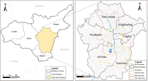
This paper takes the downtown area of Taiyuan as the research area because it is the place where social and economic activities occur most frequently. As of December 2018, it has a total area of about 1411.74 km2 (), 68 census units with 3.75 million populations, and an urbanization rate of 84.88%.
Figure 1. The study area in Taiyuan.
2.2. Data source
2.2.1. Parks
Parks are public facilities in the city that are open to the public and have certain recreational and service facilities, as well as ecological maintenance and environmental beautification. It is an important indicator to show the overall environmental level of the city and the quality of life of residents. In the Classification Standard of Green Space System Planning of Taiyuan (2015–2020)Footnote2, urban parks are divided into five categories: comprehensive park, district park, community park, theme park, and roadside green space according to different indices like function, area, and service radius (). With the rapidly expansion of urbanization and the surge in population, residents have higher demands for urban green space and the leisure facilities it provides. Considering that the parks in this study are closely related to residents’ daily leisure activities, emphasizing recreation and entertainment functions, we choose parks that are open to the public free of charge with large areas and relatively complete service facilities. Theme parks and roadside green space are not included in the scope of this study because of the charging policy or the lack of any service facilities. We mainly focus on three types of urban public parks:
Urban comprehensive parks (UPs) aim to provide city residents with weekend leisure, entertainment and sightseeing services. It is one of the main contents of urban construction and an important part of the urban ecological system and urban landscape;
District parks (DPs) are designated to provide rich activities and facilities for residents in a certain region;
Community parks (CPs) are generally arranged in combination with residential land and are divided into residential parks and community parks. They are designated to serve community residents with daily leisure purposes, such as walking after a meal, or weekend recreational sports.
Table 3. Relevant descriptions of parks in Taiyuan.
This study obtained the list and geographic distribution map of three types of parks in Taiyuan in 2018 from the Taiyuan City Planning Bureau, and manually extracted and edited the park patches in ArcGIS 10.2, including the shape (excluding water bodies) and attributes (e.g. name, area and location). And then Baidu MapsFootnote3 was used to update the geo-location and shape of three categories of parks, and extract the entrances and exits. Finally, the spatial distribution map of parks in the study area in 2018 was obtained (). Some previous studies used the central point of the park as the entrance to some open green spaces to calculate accessibility. In this study, entrances and exits are regarded as entrances to parks with walls or fences. For an open park, we chose the entrance or exit of its adjacent road or intersection. There are a total of 168 parks in the study area, including 39 UPs, 51 DPs, and 78 CPs. The entrances and exits of 106 public parks were obtained. The remaining parks used their adjacent roads or intersections as their entrances. The statistical values of parks in each district of Taiyuan are shown in .
Figure 2. Different types of parks in Taiyuan in 2018.
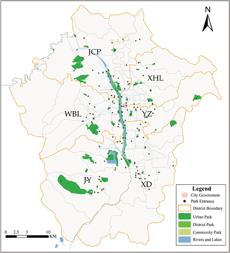
Table 4. Descriptive statistics of parks in Taiyuan’s districts in 2018.
2.2.2. Selected variables
Considering the availability of data, variables were selected against other related literature and previous studies in an attempt to examine Neutens et al. (Citation2010)’s hypothesis that people-based accessibility may be more accurate at detecting social equity. summarized all the variables and the general descriptive statistics employed in this study. The list of independent variables was divided into three dimensions:
Table 5. Descriptive statistics at the grid scale.
2.2.2.1. Demographic characteristic
The data comes from the Sixth National Population CensusFootnote4 in China and Statistical Yearbook of 2019 in TaiyuanFootnote5, describing general population characteristics. It includes the portion of people in the census block (sub-district level) under the age of 15, above the age of 65, men, women, with local city hukou, marriage rate, subsistence allowance households, the employed, the unemployed, as well as the population of local residents and migrants;
2.2.2.2. Social-spatial structure
It includes the population density of local residents and migrants, as well as the average housing price in 2018. Population density is the ratio of the number of residents to their living area (ha); Housing prices are calculated based on the average price of commercial housing in the region.
2.2.2.3. Socio-economic status
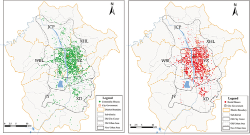
Since income level is not available in China’s census, housing type is then used as an indicator of socioeconomic status following Liao and Wong (Citation2015). Their studies found that the socioeconomic status of people is closely related to their housing type: wealthy families mostly live in commercial houses as homeowners, while low-income groups are more likely to choose to rent because of insufficient financial capacity. After 1998, China ended the welfare housing system, and commercial housing became the dominant source in the housing market. So people’s socioeconomic status has been shown to be profoundly attached to housing types (Li and Wu Citation2008). In this study, the general residential information of Taiyuan was obtained from the FangtianxiaFootnote6. It is one of China’s web-based housing deal platforms that can provide services for real estate and rental deals. We extracted the attributes of residential communities from the sectors of real estate in Fangtianxia website using the Python code on 12 January 2019. The data contains two housing types: commercial housing and rental housing. Commercial housing also includes the new and secondhand estate on sale. We obtained the 912,401 commercial housing of 3078 communities and 118,450 rental housing of 2041 communities in the study area, including the name, location, price, and the total number of households of the real estate (). Administrative divisions and street boundary data are collected from the Geographical Information Monitoring Cloud PlatformFootnote7.
Figure 3. Distribution of commercial housing and rental housing in the study area in 2018.
2.2.3. Research scale and data processing
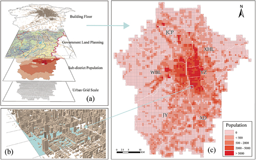
This study used a weighted population grid to capture the urban population pattern. Many of the previous geographical studies have been conducted at the sub-district level, which is treated as the smallest geographic unit in the Chinese census. But the obvious disadvantages are: (a) The accessibility calculated by using the center point method will not be objective enough if the sub-district area is too large; (b) The statistical data based on sub-district level assumes a unified population distribution, which does not conform to the actual population distribution. Tan and Samsudin (Citation2017) showed that the research scale can greatly affect the evaluation of parks and argued that exploring equity on a smaller scale would be highly rigorous and scientific. In view of the above analysis, this paper divides the census units into 500 m × 500 m square grid units (n = 5640) based on the previous studies(Xing et al. Citation2018). The accessibility measurements were performed at the grid scale, and changes and other analysis combined larger scales (such as district) based on the grid scale. Considering the general uneven distribution of population, we estimated the spatial distribution of population based on the weight of urban buildings and the construction land area (). The specific process is as follows:
The bottom areas and the corresponding number of floors of all buildings of Taiyuan in 2018 were obtained based on the Baidu Map API platform (https://lbsyun.baidu.com/). To accurately identify rural residential land in remote areas without building data coverage, we extracted the construction land from the “Land Use Planning in Taiyuan (2012-2020)” and superimposed satellite imagery to obtain the rural residential land in these blind areas as accurately as possible. Finally, urban buildings and rural residential areas are overlapped to obtain the final construction land;
Allocated the population of each sub-district to its construction land, and divided the sub-district area into 500 m × 500 m grids;
Superimposed the construction land population and the grid. The population weight was calculated by the ratio of the building area and the corresponding number of floors in each grid to the total building area in the sub-district. The population within each grid is estimated based on the population weight. The calculation is shown as formula 1:
(1)
Figure 4. Population estimation in the study area: (a) Database creation, (b) Building exhibition, and (c) Population distribution in space.
where is the potential ith type population of mth grid in nth sub-district;
is the base area of the jth building in the mth grid of nth blocks, and
is the corresponding number of floors of jth buildings;
is the total building area of the nth block where the mth grid is located;
is the number of ith type population in the nth block.
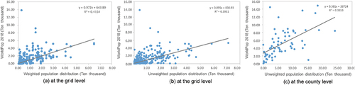
Due to the limitation of data acquisition, the basic population data used in the study is the sixth population census, which has a certain time lag. To verify the validity of the data and the rationality of our proposed population-weighting algorithm, we analyze the correlation between our dataset and the widely used WorldPop dataFootnote8 (WorldPop2018 was selected, describing the population density in China at a resolution of 1 km2). shows that the population data used in this study is significantly correlated with WorldPop2018 at the 0.01 level, and the weighted grid-based population distribution performs better. further shows their strong linear relationship. These results confirm the rationality and validity of our estimated population distribution. On this basis, we further counted the population of different social groups, the rental housing, the commercial housing and the corresponding total number of households within a grid. Due to China’s family planning policy (one-child policy), we estimated the population of high-income and low-income groups separately according to three persons per household. The final statistical results are shown in .
Table 6. The correlation coefficient between different types of population distribution and WorldPop2018.
Figure 5. Linear relationship between population distribution based on the sixth census and the WorldPop2018 in Taiyuan.
Before modeling, all variables were normalized by the logarithmic transformation to reduce heteroscedasticity (Kerkhoff and Enquist Citation2009). Such a step can make different features have the same scale and stabilize the distribution close to the normal distribution, which is conducive to the reliability of the results. The calculation is shown as formula (2):
where is the value of ith variables, and
is the value of ith variable after the logarithmic transformation.
3. Methodology
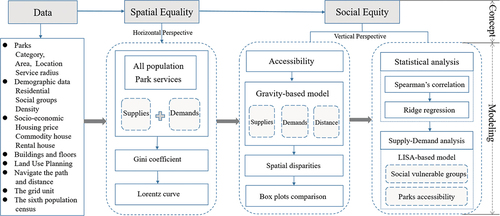
This paper explores the relationship between different social groups and the parks distribution in a given area, and to test whether urban parks are equally distributed among residents. The research methodology involves four steps, namely, (1) analyzing the equality of park allocation from a macro perspective, (2) measuring park accessibility, (3) exploring social equity in access to parks by different social groups, and (4) analyzing the spatial differences of supply and demand patterns of parks and their causes. presents the integrated methodological framework. The following sections explain these steps in detail.
Figure 6. Research flowchart.
3.1. Gini index and Lorenz curve
As the most widely used measures of inequality, we employ the Gini coefficient as a global evaluation index for park allocation equality and adopt the Lorentz curve to denote the rank-ordered cumulative distribution of park service levels. The percentages of population and parks are plotted separately on the x- and y-axes of the Lorentz curve, where each point represents the amount of the park services (y%) occupied by x% of the population. The Gini coefficient is computed as:
where Pm is the cumulative proportion of population variables in the region, and Rm is the cumulative proportion of parks variables. A higher Gini coefficient (i.e. closer to 1) indicates an extremely uneven park distribution.
3.2. Measuring spatial accessibility to parks
3.2.1. Gravity model
Accessibility can be measured in many ways. In this study, the Gravity model proposed by Hansen (Citation1959) is adopted for its two theoretical advantages. First, this model can sensitively reflect changes in travel time or distance because the interaction between two points decreases along with an increasing cost (travel time or distance). Second, this model can prevent the potential service generated by the service scope method from being equal to 0. Given that traditional “container” methods, such as 2SFCA, calculate accessibility based on a certain service range, the accessibility of the community outside the service scope of a facility becomes equal to 0 and ignores the movement of people (Kim and Nicholls Citation2016). However, the service provision of real public facilities should not be limited to specific geographic boundaries because in theory, a person can access all public facilities regardless of his/her location. Therefore, for all residents, the potential accessibility should always be greater than 0. In this case, the accessibility of parks can be reasonably compared and described by using the Gravity model. We assume that a community can interact with all parks in the study area, and we build the following unified evaluation indicator for different types of parks:
where Ai is the accessibility of the ith grid, j is the corresponding park, n is the number of each type of park, Sj and Vj are the area and demand of the jth park, respectively, dij is the shortest distance between the ith grid and jth park, Pk is the population of the kth grid, m is the number of grids, djk is the shortest distance between the jth park and kth grid, and β is the distance decay parameter.
3.2.2. Estimation of travel distance
Distance is a key indicator of spatial accessibility. Some previous studies used assumed speed of a network to calculate the distance related to accessibility (Xing et al. Citation2018). This study relies on Baidu Map Route Planning Application Programming Interface (API) (https://lbsyun.baidu.com/index.php?title=viewstatic) to obtain the traffic navigation distance between the starting point and the ending point. Baidu Map is a popular online map, navigation, and location service provider in China that use real-time data to provide more accurate and reliable results than previous planning-based for speed distribution. There are two obvious benefits of using the route planning service: First, it fully considers traffic obstacles and jams in path planning to reflect actual time consumption of residents. Second, large parks generally have multiple entrances. The real-time navigation map route planning services will enable the system to automatically select the entry point closest to the user’s current location. The specific process is as follows: (1) Register as a Baidu Map developer and obtain the secret key (AK); (2) Establish the path planning service of the starting point and the end point through the RouteMatrix API; (3) Select the shortest distance calculation strategy. Finally, we obtained 947,520 shortest path distances between 5640 starting points and 168 destinations by accessing the Baidu Map API.
3.2.3. Distance decay parameter
Zhengna and Wen (Citation2009) summarized the range of distance decay parameter (β) and found that the value of β is concentrated between [1, 2]. Dony, Delmelle, and Delmelle (Citation2015) also pointed out that when β is high, the demand for parks decreases faster along with an increasing distance. Given that the spatial relationship between different levels of parks and residents significantly varies along with distance (i.e. the spatial connection between comprehensive parks and residents is weakened along with changing distance), we follow the findings of previous research(Arbia and Petrarca Citation2013; Luo and Wang Citation2003) and assign attenuation coefficients of 1, 1.5 and 2 to UPs, DPs and CPs, respectively.
3.2.4. Violin and box plots
To further compare the accessibility levels of different types of parks in Taiyuan, we use violin and box plots to establish a baseline image of the distribution of park accessibility variables by block group. Specifically, we use the violin plot to display the data distribution and probability density, and use the box plot to compare the data. This study attempts to test for the uneven or unequal spatial distribution of parks in Taiyuan. To eliminate non-normal distribution and heteroscedasticity, we logarithmically transform all our data before generating the plots.
3.3. Statistical analysis
The statistical analysis is divided into three steps. First, we check for any variability in the relationship between accessibility and our variables. Second, we explore those indicators that affect accessibility changes and their relative contributions. Third, we analyze the spatial supply – demand contradiction between vulnerable groups and park distribution. The following sections explain these steps in detail.
3.3.1. Bivariate analysis
Considering the possible spatial autocorrelation of the explanatory variables, it is necessary to analyze whether there is multicollinearity among variables firstly. In general, the most direct representation of multicollinearity is that the correlation coefficient between explanatory variables is very large (close to 1). So Spearman’s correlations are used to check for the multicollinearity between variables, as well as variabilities in the relationship between park accessibility and statistical variables. It is a non-parametric indicator that measures the interdependence of two variables to assess whether the accessibility distribution of urban parks is statistically related to factors, such as age, gender, status, income, and social spatial structure, and to control the influence of other possible related explanatory factors.
3.3.2. Ridge regression
Spatial autoregressive analysis is used to identify the key variables related to the accessibility of urban parks. Given the possible spatial autocorrelation of the variables, the obtained multiple linear regression model is very unstable and unable to objectively and accurately reflect the actual situation. According to the decision rules recommended by Hoerl and Kennard (Citation1970), Ridge Regression is the most appropriate method to apply in this case. Ridge regression is a basic machine learning regression algorithm that prevents overfitting and improves the generalizability of the model. Compared with traditional linear and OLS regressions, ridge regression can improve the accuracy of the prediction model, remove the collinearity problem that the OLS estimation cannot overcome, and avoid autocorrelation interference between indicators (Christensen, Jorgenson, and Lau Citation1973). In this case, the estimated coefficients become in line with the objective reality. Based on the above analysis, we establish the following ridge regression model:
where x is an independent variable, y is a dependent variable, βj is the regression coefficient to be determined, β0 is a constant term, and k is a ridge regression parameter (k ≥ 0). As k increases, the coefficient vector β becomes more vociferously constrained toward 0. The most common method for selecting the value of k is the ridge map, which generally takes a smaller value when the ridge trajectory tends to be stable.
3.3.3. Spatial clusters of variables
Spatial distribution is generally studied from a statistical perspective by using spatial autocorrelation models (Dai et al. Citation2017), including global Moran’s I statistics and bivariate Moran’s I statistics. This study uses both of these models to solve for the correlations of spatially correlated disparity factors. Specifically, we use global Moran’s I to describe the spatial autocorrelation of park accessibility, and we obtain the spatial correlation local indicator (LISA) based on local Moran’s I (Forey, Lortie, and Michalet Citation2009) to analyze the local clustering characteristics of population and parks in space. The spatial distribution patterns can be classified into H-H, H-L, L-H, and L-L types according to the clustering results. Calculated as follows:
where xi and xj are accessibility values of grid i and j, respectively, is the average accessibility in the whole study area, n is the total number of grids, and Wij is the spatial weight matrix.
4. Results
4.1. Spatial equality of urban parks
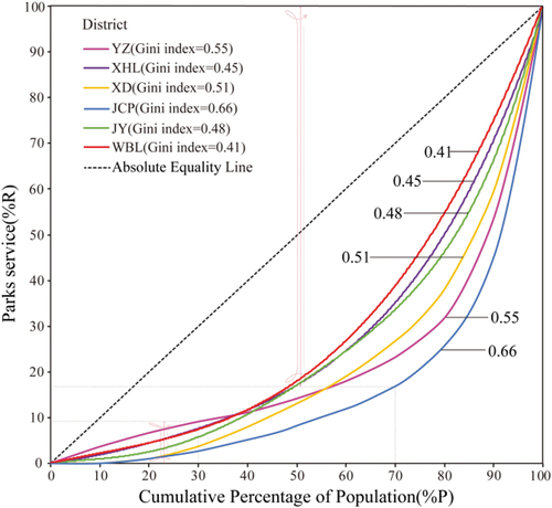
The Gini coefficient is used to evaluate the regional inequality of parks’ services in different urban areas of Taiyuan. The Lorentz curve indicates the distribution of parks among the residents. shows a serious inequality in parks distribution in six urban areas among the residents. First, the parks in the WBL district have the smallest deviation from the line of complete equality and the lowest Gini coefficient (0.41), whereas the JCP district has the largest Gini coefficient (0.66), indicating a highly unfair resource allocation. Second, 30% of the population in all urban areas enjoy less than 10% of the parks, while most parks are concentrated in the other 30% of the population, thereby reflecting an extreme mismatch between parks and population. It can be seen that parks in Taiyuan demonstrate an obvious regional inequality. While the Gini coefficient and Lorentz curve can only describe the equality level of parks distribution in each urban district as a whole, and cannot reflect the spatial matching pattern between the distribution of parks and residents.
Figure 7. Gini coefficient and Lorenz curve.
4.2. Spatial distribution of park accessibility
4.2.1. Spatial disparities in accessible parks
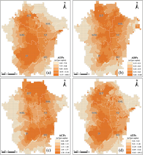
shows the spatial distribution of park accessibility in Taiyuan. It reveals the spatial matching pattern of parks distribution and population distribution. In general, the ATPs in the new urban area is better than that in the old urban area, and the old city center with the highest population density enjoys worse park resources. Specifically, AUPs and ACPs are highly in the new urban area of Taiyuan, where the distribution of high accessibility values is relatively concentrated. However, the old urban areas have better ADPs. Besides, the huge difference between the extreme values of accessibility of UPs and CPs also highlights a serious distribution mismatch of these two types of parks in space. (e.g. the lowest AUPs is 4.62 m2 per capita, whereas the highest is 1060.30 m2 per capita).
Figure 8. Spatial accessibility to different types of parks in Taiyuan (Quantile classification is used to divide the accessibility results into five categories): (a) is the accessibility to UPs (AUPs), (b) is the accessibility to DPs (ADPs), (c) is the accessibility to CPs (ACPs), and (d) is the total accessibility of parks (ATPs) in a certain area (the sum of the accessibility of three types of parks).
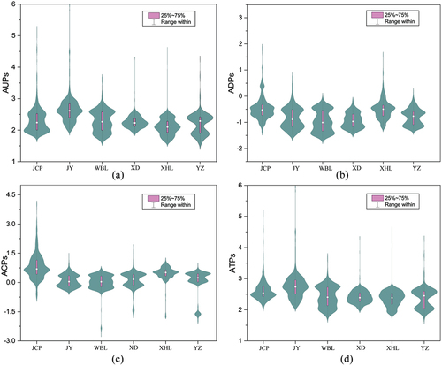
4.2.2. Violin and box plots comparison
The violin plot compares the accessibility levels of different types of parks in the six districts of Taiyuan. The distributions show high levels of variation in level and spread of all types of urban parks in the entire study area. reflects the differences in the level of park resources available in the six urban areas, among which the WBL district has the worst accessibility and the largest fluctuations. For different types of parks, the AUPs are highly concentrated below the median, thereby suggesting that half of the population’s AUPs are lower than the average; The ADPs is all multi-peaked, thereby revealing a highly uneven distribution of DPs in the six urban areas; The ACPs showed obvious long lower whiskers, thereby indicating that most residents in the area have poor CPs.
Figure 9. Accessibility of different types of parks per block group.
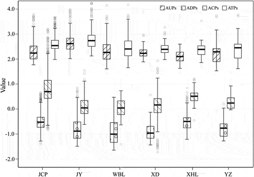
further compares the spatial distribution of the differences in the accessibility levels of different types of parks. In general, the ATPs are the highest in JY and the lowest in WBL. For the three types of parks, the AUPs are much higher than ADPs and ACPs in the same district with small fluctuations; the ADPs have the lowest average level; and the ACPs relatively show obvious fluctuations in space. These results suggest that parks are unevenly distributed among population in most urban areas of Taiyuan. In addition, the CPs are particularly inclined, and few residents can enjoy high-level community parks. The results motivate us to further explore whether urban parks are equally distributed among all people, and whether such spatial equity is related to certain factors, such as age, gender, class, wealth, and others.
Figure 10. Box plot comparison of park accessibility in different districts.
4.3. Relationship between park accessibility and social factors
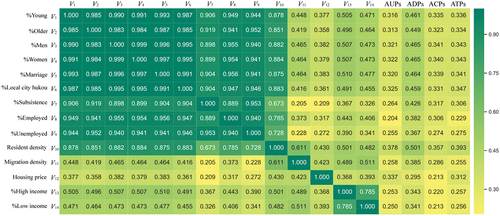
Spearman’s correlations are used to check for the multicollinearity between variables, as well as variabilities in the relationship between park accessibility and statistical variables. presents the results of bivariate analyses in a condensed format, and heat map coloring is used to indicate the relationship between different types of park accessibility and variables of social groups and the strength of correlations among the driving factors. All results are significantly correlated at p < 0.05. The large correlation coefficients (close to 1, the green-colored blocks in ) among the explanatory variables indicate the existence of multicollinearity. It will make the traditional multiple linear regression model very unstable, and unable to reflect the actual situation objectively. These results motivate us to build a better model to explore important indicators that affect accessibility changes and their relative contributions.
Figure 11. Spearman’s correlation coefficient results.
4.4. Significant metrics and relative contributions influencing accessibility variations
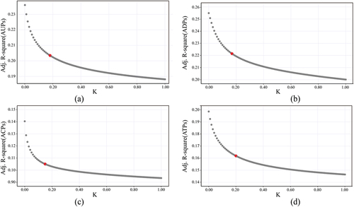
The entire research area is modeled via ridge regression, with AUPs, ADPs, ACPs, and ATPs serving as dependent variables to determine the relationship between the spatial distribution of park access and each variable. Starting from ridge value K = 0.01 and iterating in steps of 0.01, the optimal K value () is selected to obtain the regression results (). reflects the relationship between adjusted R-square and K values. All models have performed well and are significant at a 5% confidence level. The ADPs have obtained the highest adjusted R-square value and explain approximately 22% of the variations in the model.
Figure 12. Ridge plots for different types of parks and variables.
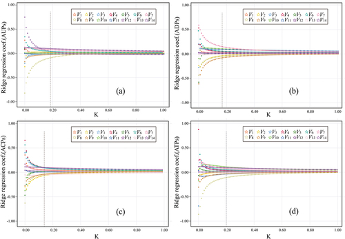
Table 7. Ridge regression results.
Figure 13. The relationship between adjusted R-square and K for different types of parks.
The model results in revel that the accessibility level of parks significantly varies among variables. Young people have better ADPs and ACPs, whereas the elderly have better AUPs. Compared with men, women are more willing to choose parks for recreational activities, and neighborhoods without parks have a higher proportion of married families. Citizens with local city hukou and subsistence allowances enjoy better park resources, while the employed and unemployed have poor park accessibility. Besides, the density of local resident has a significant advantage in access to parks in the model, while the internal migrants are at a statistically significant disadvantage. With regard to the relationship between socioeconomic status and park accessibility, those residents with commercial housing show a very weak relationship with parks, and those areas with high park accessibility have a high percentage of renters, especially near community parks. In addition, housing prices have a significant positive impact on park accessibility, suggesting that urban development is closely related to the allocation of public facilities. Obviously, a faster development of the city corresponds to a better construction and distribution of public resources.
4.5. Spatial pattern of contradiction between supply and demand of parks
The study used the bivariate LISA map further analyze the spatial pattern of supply and demand between the statistically disadvantaged variables in Section 4.4 and the distribution of parks in order to fully understand the core concepts of social equity. The park accessibility is used to represent its supply level, and the population density of different groups is regarded as their demand for parks. shows four types of spatial cluster pattern between different types of parks and statistically disadvantaged variables at the grid scale in Taiyuan. Statistically significant blocks are highlighted by different colors, with light blue indicating low demand and high supply and light pink indicating the opposite. Both of them have significant Moran’s I at the 0.001 level, thereby indicating a spatial correlation.
Figure 14. Bivariate LISA map of parks accessibility and statistically disadvantaged variables in Taiyuan (V2: %old; V5: %marriage; V8: %employed; V9: %unemployed; V11: Migration density).
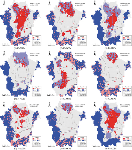
The LISA map () shows that the clustering pattern between the spatial distributions of different types of parks and social groups varies significantly across Taiyuan. Areas of H-H and H-L differed spatially, depending on different types of parks. For V2-ADPs, V5- ADPs, V9- ADPs, and V11- ADPs, the H-H areas are mainly concentrated in the core area of the old urban area, while the H-L areas are mainly concentrated in the north of the old urban area. The H-H areas for V2-ACPs and V5-ACPs are concentrated in the north of the old urban area and some core area of the new urban area, while the H-L is mainly distributed in the north of the city. The H-H areas of V8-ACPs and V9-ACPs are generally only concentrated in the urban-rural junction in the north of Taiyuan. For V8-AUPs, the H-H areas are distributed in the new urban area (mainly in JY District); The areas of L-L and L-H are concentrated in the urban-rural junction, especially dense in the northeast. Besides, Other types areas of L-L and L-H are basically concentrated in remote mountainous areas outside the urban area, especially in the south of the city.
5. Discussion
The results provide some important insights for assessing the parks’ inequity in Taiyuan and some guidance for urban park planning. This section further discusses the implications of these results, identifies the possible influencing factors, and highlights other areas for future research.
5.1. The significance of the results
reveals the accessibility level of parks significantly varies among social groups, thereby proving that the actual access level of people to parks is stratified according to their age, gender, status, wealth, and other characteristics. For example, young people under the age of 15 have better access to nearby district parks and community parks. We reasonably guess that teenagers may not be allowed by their parents to go to the farther comprehensive parks alone due to their young age, and small parks near home becomes their best choice. On the contrary, the elderly with sufficient time after retirement prefer to go to long-distance city parks to relax. After all, large parks can provide a better green environment and recreational facilities. In addition, as different people have different needs for public facilities, some groups cannot enjoy good parks. For example, compared with women, men are less sensitive to park accessibility, and the proportion of married families in blocks without parks is higher. It may be families with children prefer to live in areas with better schools or shopping facilities. Citizens with local city hukou and subsistence allowances can enjoy better parks, thereby suggesting that the distribution of parks is relatively equal among locals. While urban vulnerable groups such as the unemployed and internal migrants are at a statistically significant disadvantage in our model. It has long been believed that, compared with urban residents, the domestic floating population in China is discriminated in system (Li and Wu Citation2008). Our regression model validates this view. Both the unemployed and the migrants show significant disadvantages suggesting that the distribution of parks in Taiyuan is indeed not conducive to some social vulnerable groups. In the past, social factors were not fully considered in the planning and construction of parks, and the distribution of resources was obviously inclined to the locals.
Socioeconomic variables seem to be less relevant effects on parks than others as reflected in the weak correlation between socioeconomic factors and park accessibility. Those who own commercial houses have a very weak relationship with parks, and areas with high park accessibility have a high percentage of renters, especially near community parks. These results are surprising because according to China’s national conditions and people’s common sense, residents living in commercial housing are generally wealthy and have more choices in accommodation and surrounding facilities compared with the poor. The results may be ascribed to several factors. First, this finding may be related to the opportunity for each group to choose leisure. Groups with a favorable economic status can have more choices, whereas the low-income groups are dependent on public facilities due to economic constraints and tend to live in areas with convenient transportation. Second, we speculate that most closed communities of commercial housing may be provided with green spaces and entertainment facilities (Li, Zhu, and Li Citation2012), which can meet the daily community leisure activities of wealthy families. Besides, Jennings and Gaither (Citation2015) found that an unfair distribution of green areas was related to health differences and that low-income groups tended to experience poor living environments (Nesbitt et al. Citation2019). Full exposure to green vegetation can mitigate negative environmental impacts (Wolch, Byrne, and Newell Citation2014), so low-income residents may have more access to parks than others.
In our model, the elderly, married families, the employed and unemployed, and migrants are at a disadvantage in access to parks. further analyzes the spatial supply and demand relationship between parks and the above statistically disadvantaged variables. The cluster map shows that the supply-demand mismatch is mainly concentrated in three areas: the urban-rural junction, remote mountainous, and parts of new urban areas. Specifically, the mismatch areas between the elderly, the married, migrants and parks are mainly concentrated in the core urban area and the urban-rural fringe; the mismatch among the employed, the unemployed and parks is mostly distributed in remote mountainous areas. The primary reason for the spatial mismatch may be the high population density and insufficient parks in the urban area. Besides, new urban areas, as a product of urban evolution and development, has perfect public facilities. But the concentration of industrial parks and high-tech zones has produced many land benefits and results in high housing price. So the density of social vulnerable groups is low in those new urban area. These factors all lead to an imbalance in the supply of parks.
5.2. Is there social inequity in access to urban parks in Taiyuan?
This paper studies the distribution equity of urban parks in the public resource equity system. It includes not only spatial equality, but also the equity to meet the needs of different groups. That is, some citizens will not lose the opportunity to enjoy parks due to external reasons such as differences in socioeconomic conditions.
Some researches pointed out that the inequality in Chinese cities continues to worsen (Logan, Fang, and Zhang Citation2009; Li and Wu Citation2008). It has been fully recorded that citizens in different cities obtaining public resources (e.g. parks) usually related to the traditional privilege sign. For example, ethnic minorities (Comber, Brunsdon, and Green Citation2008) or poor groups (Lara-Valencia and Garcia-Perez Citation2015) are more likely to have limited access to parks. When parks distribution is combined with social systems, the degree to which different groups access parks in Taiyuan has obvious differentiation. Some social vulnerable groups such as the elderly, the unemployed and the migrants are given an unequal park supply because our model presents a negative result for park accessibility. Specifically, compared with local residents, the marginalized groups are at a disadvantage when entering urban parks. This finding also verifies the view that domestic migrants are discriminated institutionally.
Population density can be used as an alternative indicator of the building environment to a certain extent and plays a critical part in the distribution of urban parks. Consistent with previous studies, our findings show that local population density positively influences entrance to parks. For instance, Nicholls (Citation2001) pointed out that Bryan residents living in densely populated areas of Texas in the United States have better park services. The similar case can be observed in Taiyuan, where both the high values of population density and accessibility are distributed in the core circle of the city. However, the problem is that the number of people per unit of park area increases along with population density, thereby causing the potential traffic congestion and affecting some citizens to enter parks.
Since urban parks are agents of ecological space guided and constructed by the government, and have strong social welfare characteristics. Given that parks are generally scattered and sparsely distributed in cities, their unfair distribution can be widely regarded as a social problem and seems to be understood. However, Boyce, Zwickl, and Ash (Citation2016) pointed out that social equity, from the social welfare perspective, is a normative principle of equal opportunity that is not related to socio-economic status, gender, and race, among others. We should fully consider and maximize the needs of all social groups. Following this argument, we can conclude that parks in Taiyuan also exhibit social inequities.
5.3. Exploring the causes of inequities
The social inequity of different groups enjoying parks in Taiyuan may be ascribed to several reasons. First, the past development of the city may have a “legacy impact” on its current urban form. For example, due to the limited land resources in the old urban area of Taiyuan, creating new parks on the original built-up area becomes difficult even after multiple real estate renewals or redevelopments (Tan, Wang, and Sia Citation2013).
Second, such social inequity may be related to the urban development plan of Taiyuan. In recent years, Taiyuan has shifted its urban development and construction efforts southward. The land use and organization in the new urban area are different from those of the old area. It has the necessary land conditions to plan the construction of large and comprehensive parks. In addition to economic development, the government has also invested some of its energy and financial resources into measures to maintain urban ecology and to build a harmonious environment, such as the planning and reconstruction of Jinyang Lake and the construction and expansion of the Fen River Ecological Park. Therefore, public facilities in the new urban area are completely planned. But the concentration of industrial parks and high-tech zones has produced many land benefits and results in high housing price. So the density of social vulnerable groups is low in those new urban area. The efforts also indicate that the leading role of the government in urban planning may have a greater role in achieving a fair public resource allocation compared with other factors, such as poverty and floating population.
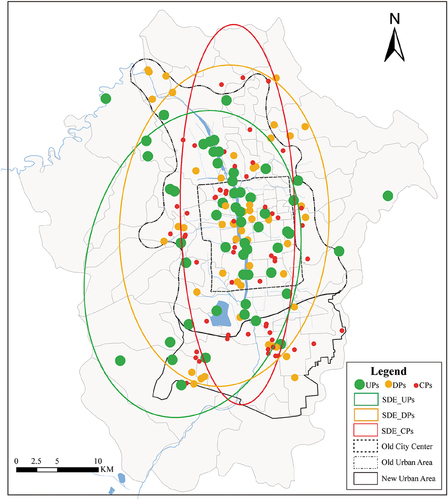
Third, the park planning department of Taiyuan has not paid enough attention to the planning of CPs. Following the release of the “Thirteenth Five-Year Plan” for the landscape greening of Taiyuan City in 2015 (2016–2020), the goal is to allow 90% of residents to see greening within 500 m travel distance by 2020, then some people have begun to focus on small-scale park construction. We use the Standard Deviation Ellipse (SDE) to identify the central, dispersion, and direction trends of parks and find that the long axis of CPs is the longest and the short axis is the shortest with polarization (), thereby suggesting that CPs are mostly concentrated in the old city, but their development direction toward the new city is obvious. These results further confirm our conclusion that the government has begun to attach importance to the construction of small-scale parks.
Figure 15. Spatial distribution of the center of gravity and direction of parks in Taiyuan.
Fourth, the government (Taiyuan Citation2015) and study have both acknowledged that the planning and construction of new parks lag behind those of residential buildings in Taiyuan. Given the rapid economic development over the past 10 years, many farmers and outsiders have flooded into cities to seek employment opportunities. From 2000, Taiyuan’s population has increased by 75.93% and its urbanization rate has reached 84.88%, which is close to that of developed cities in China, such as Beijing (86.5%), Shanghai (88.1%), and Guangzhou (86.38%). However, the construction of Parks in Taiyuan is relatively lagging, and the green space rate of the city has increased from 28.8% in 2000 to 37.74% at present. The serious imbalance between supply and demand is also an important factor that leads to an unfair distribution of park services in Taiyuan.
5.4. Innovations and limitations
Improving the spatial distribution of urban public facilities equity has always been an important topic in academic research. Compared with previous studies, this work provides new insights from both macro and micro perspectives. First, we use the Gini coefficient to analyze the equality level of parks in different urban districts of Taiyuan from a macro-level. Second, we simulate the spatial distribution of community populations at the micro-level to detect the possible relationship between equity in access to parks and social groups. In this process, the spatial distribution of population is estimated at the community level combining urban building and construction land, which is more reliable than ignoring population distribution or assuming uniform population distribution at a specific administrative boundary scales in previous studies. In addition, greater inequality can be observed at smaller spatial scales, which also facilitates further fine-grained analysis, and help planners more accurately locate areas with insufficient or excess supply of urban park facilities. Methodologically, ridge regression is used to test whether the values of park accessibility was related to any demographic variable, which can better avoid the estimation bias caused by the interdependence among demographic variables. This approach helps us understand the possible relationship between equality in access to parks and specific social groups. Besides, fine-scale supply-demand analysis also makes it easy to identify vulnerable groups with poor spatial resources and consider compensation in future planning to alleviate spatial inequity. In the case, taking Taiyuan as the research area also fills the gap for second-tier cities in this kind of research. Our proposed methods are based on open data and easy to implement. The framework also provides a new perspective for the future study of urban public resources, and can be used as a reference in follow-up research on accessibility and social equity in other city.
Several aspects need to be further considered in future research. First, the data deviation. This study used fine population classification data from the sixth census in 2010 due to the limitation of data acquisition, while other data were almost from 2018. Although we considered the spatial population distribution based on building scale and tested with the WorldPop2018 dataset to reduce errors, time lags can still introduce some potential bias. Similarly, the economic status identified by housing types may also differ from the actual economic spatial structure and lead to an inaccurate estimation result. Using absolutely accurate data for analysis is beyond our research capabilities, but given the importance of data precision in determining power and difference, future research needs to take this into account.
Second, the endogeneity of variables. The core of this paper is to explore the equity of different social groups in access to parks in Taiyuan. Although we carefully selected variables based on the published literature, there may still be missing variables or variables with some measurement errors, which may cause endogenous problems. Exploring the differences in access to public resources among different social groups may depend not only on their category and spatial distribution, but also possibly relate to their other characteristics (e.g. health status, vitality, personal preferences, etc.). However, such more sophisticated data acquisition is beyond our capabilities, but warrants further study in the future. Our accessibility-based analysis is a physical and mathematical expression, and future research can improve our understanding of social equity by considering the diverse characteristics and psychological choices of different users.
Third, we did not consider the role of public and private lands in the distribution of urban parks. With the rapid economic development of Chinese cities, owning green spaces gradually becomes a trend among the rich as reflected in the existence of green facilities in private commercial and residential communities (Xiao, Li, and Webster Citation2016). This trend may also explain why rich communities have poor access to parks in our results. Nesbitt et al. (Citation2019) pointed out that private land usually contains a large part of urban vegetation, thereby making this land an important contributor to solving the inequality in the allocation of green spaces. However, as we are unable to distinguish public from private lands except for the park area in Taiyuan, we cannot prove that the green spaces in private or public land are indeed the main cause of inequity. Future research may explore this problem further.
Last, we did not consider the edge effect of parks. As our research objects are parks in Taiyuan, the park outside the study area is not taken into consideration. While for those living near the edge of the city, the park outside the study area may be the nearest. This may also cause some bias in the results.
6. Conclusions
This paper presents a new refined methodological framework that integrates gini coefficient, lorentz curves, gravity model, ridge regression algorithm, and statistical methods to understand the equity in the spatial provision of urban parks. Compared with previous studies, we reveal the equity in access to parks from both urban macro and micro perspectives. From a macro perspective, the allocation of three types of parks among six urban areas in Taiyuan shows serious spatial inequality, especially for community parks. From a micro perspective, the actual level of people’s access to parks is also stratified by their characteristics, including their age, gender, identity, and socioeconomic status. Many social vulnerable groups are at a disadvantage in this case, and the supply – demand imbalance between them and parks is mainly observed in the urban – rural junction and the new urban area. Therefore, these areas warrant further attention. This paper reveals that an unfair distribution of public resources can also be observed in second-tier cities in China, and the social performance of basic public facilities and services is closely related to the spatial distribution of social groups. To a certain extent, our findings provide some references for the Taiyuan government to adjust its park layouts, alleviate social contradictions caused by injustice, and promote the harmonious and sustainable development of the city. These findings can also aid future research on the equity of public facilities in small- and medium-sized cities in China.
Disclosure statement
No potential conflict of interest was reported by the author(s).
Data availability statement
The data that support the findings of this study were derived from the National Bureau of Statistics at http://www.stats.gov.cn, the Taiyuan municipal government website at http://ylj.taiyuan.gov.cn/and other resources available in the public domain. Derived data are available from the corresponding author.
Additional information
Funding
Notes on contributors
Jing He
Jing He is now a PhD student at Wuhan University. Her research interests include spatial analysis and data mining.
Fu Ren
Fu Ren is a professor at the School of Resources and Environmental Sciences, Wuhan University. His main research interests are intelligent mapping, cartography and geographic information visualization.
Jiaxin Dong
Jiaxin Dong is now a PhD student at Wuhan University. Her main research interests are remote sensing and complex network analysis.
Huihui Zhang
Huihui Zhang received her PhD degree at Wuhan University in 2021. She is now a postdoctoral researcher at Humboldt University in Germany. Her research interests include geographic modelling and hydrology.
Wenhao Yan
Wenhao Yan is an engineer at the Land and Resources Technology Center of Guangdong Province. His research interests include spatiotemporal data mining and programming.
Jiping Liu
Jiping Liu is now a researcher at the Chinese Academy of Surveying and Mapping. He has long been engaged in the research of geographic condition monitoring, spatial data mining and geographic information service.
Notes
1. The New First-tier Cities Research Institute of China released a new classification list of Chinese cities on May 24, 2019. According to the five-dimensional index of commercial resource agglomeration, urban hub, urban activity, lifestyle diversity and future plasticity, Chinese cities are divided into six levels, which can be seen in https://yicai.smgbb.cn/live/100191414.html for detail.
2. The Classification Standard of Green Space System Planning of Taiyuan (2015–2020) can be found at http://ylj.taiyuan.gov.cn/.
3. Baidu Maps (https://map.baidu.com/), one of the famous commercial mapping service company in China.
4. The Sixth National Population Census in China can be found at http://www.stats.gov.cn/tjsj/tjgb/rkpcgb/.
5. The Statistical Yearbook in Taiyuan can be found at https://www.yearbookchina.com/.
6. Fangtianxia (https://taiyuan.fang.com/) is a professional network platform for China’s real estate industry, providing real estate services to 658 cities in 24 countries around the world.
7. Geographical Information Monitoring Cloud Platform (http://www.dsac.cn/).
8. The WorldPop data can be found at https://www.worldpop.org/.
References
- Arbia, G., and F. Petrarca. 2013. “Effects of Scale in Spatial Interaction Models.” Journal of Geographical Systems 15 (3): 249–264. doi:10.1007/s10109-013-0180-9.
- Boone, C. 2013. ”Social Dynamics and Sustainable Urban Design.” Resilience in Ecology and Urban Design, 47–61. Dordrecht: Springer.
- Boone, C. G., G. L. Buckley, J. M. Grove, and C. Sister. 2009. “Parks and People: An Environmental Justice Inquiry in Baltimore, Maryland.” Annals of the Association of American Geographers 99 (4): 767–787. doi:10.1080/00045600903102949.
- Boyce, J. K., K. Zwickl, and M. Ash. 2016. “Measuring Environmental Inequality.” Ecological Economics 124: 114–123. doi:10.1016/j.ecolecon.2016.01.014.
- Chan, K. W. 2009. “The Chinese Hukou System at 50.” Eurasian Geography and Economics 50 (2): 197–221. doi:10.2747/1539-7216.50.2.197.
- Christensen, L. R., D. W. Jorgenson, and L. J. Lau. 1973. “Transcendental Logarithmic Production Frontiers.” The Review of Economics and Statistics 55 (1): 28–45. doi:10.2307/1927992.
- Comber, A., C. Brunsdon, and E. Green. 2008. “Using a GIS-Based Network Analysis to Determine Urban Greenspace Accessibility for Different Ethnic and Religious Groups.” Landscape and Urban Planning 86 (1): 103–114. doi:10.1016/j.landurbplan.2008.01.002.
- Cui, X., W. Liu, Z. Hou, J. Sun, and Q. Pei. 2021. “Research on the Service Level of Urban Parks in Taiyuan City from the Perspective of Equity.” Landscape Architecture Academic Journal 39 (01): 73–81. doi:10.12193/j.laing.2022.01.0073.010.
- Dai, W., H. Huang, W. Huang, W. U. Xinhai, and J. Huang. 2017. “Features of Spatio-Temporal Differentiation of Landscape Ecological Security in Island Ecologically Fragile Zones in Haitan Island.” Ecological Science 36: 152–159. doi:10.1109/CJECE.2019.2917394.
- Dony, C. C., E. M. Delmelle, and E. C. Delmelle. 2015. “Re-Conceptualizing Accessibility to Parks in Multi-Modal Cities: A Variable-Width Floating Catchment Area (VFCA) Method.” Landscape and Urban Planning 143: 90–99. doi:10.1016/j.landurbplan.2015.06.011.
- Forey, E., C. J. Lortie, and R. Michalet. 2009. “Spatial Patterns of Association at Local and Regional Scales in Coastal Sand Dune Communities.” Journal of Vegetation Science 20 (5): 916–925. doi:10.1111/j.1654-1103.2009.01095.x.
- Han, X. P., X. Huang, H. Liang, S. Ma, and J. Y. Gong. 2018. “Analysis of the Relationships Between Environmental Noise and Urban Morphology.” Environmental Pollution 233: 755–763. doi:10.1016/j.envpol.2017.10.126.
- Hansen, W. G. 1959. “How Accessibility Shapes Land-Use.” Journal of the American Institute of Planners 25 (2): 73–76. doi:10.1080/01944365908978307.
- Hartig, T., R. Mitchell, S. de Vries, and H. Frumkin. 2014. “Nature and Health.” Annual Review of Public Health 35: 207–228. doi:10.1146/annurev-publhealth-032013-182443.
- Hipp, J. R., K. Kane, and J. H. Kim. 2017. “Recipes for Neighborhood Development: A Machine Learning Approach Toward Understanding the Impact of Mixing in Neighborhoods.” Landscape and Urban Planning 164: 1–12. doi:10.1016/j.landurbplan.2017.03.006.
- Hoerl, A. E., and R. W. Kennard. 1970. “Ridge Regression - Biased Estimation for Nonorthogonal Problems.” Technometrics 12 (1): 55–67. doi:10.1080/00401706.1970.10488634.
- Houlden, V., J. P. de Albuquerque, S. Weich, and S. Jarvis. 2019. “A Spatial Analysis of Proximate Greenspace and Mental Wellbeing in London.” Applied Geography 109. doi:10.1016/j.apgeog.2019.102036.
- Jennings, V., and C. J. Gaither. 2015. “Approaching Environmental Health Disparities and Green Spaces: An Ecosystem Services Perspective.” International Journal of Environmental Research and Public Health 12 (2): 1952–1968. doi:10.3390/ijerph120201952.
- Kabisch, N., and D. Haase. 2014. “Green Justice or Just Green? Provision of Urban Green Spaces in Berlin, Germany.” Landscape and Urban Planning 122: 129–139. doi:10.1016/j.landurbplan.2013.11.016.
- Kerkhoff, A. J., and B. J. Enquist. 2009. “Multiplicative by Nature: Why Logarithmic Transformation is Necessary in Allometry.” Journal of Theoretical Biology 257 (3): 519–521. doi:10.1016/j.jtbi.2008.12.026.
- Kim, J., and S. Nicholls. 2016. “Influence of the Measurement of Distance on Assessment of Recreation Access.” Leisure Sciences 38 (2): 118–139. doi:10.1080/01490400.2015.1071211.
- Lara-Valencia, F., and H. Garcia-Perez. 2015. “Space for Equity: Socioeconomic Variations in the Provision of Public Parks in Hermosillo, Mexico.” Local Environment 20 (3): 350–368. doi:10.1080/13549839.2013.857647.
- Liao, B. G., and D. W. Wong. 2015. “Changing Urban Residential Patterns of Chinese Migrants: Shanghai, 2000-2010.” Urban Geography 36 (1): 109–126. doi:10.1080/02723638.2014.988058.
- Li, Z. G., and F. L. Wu. 2008. “Tenure-Based Residential Segregation in Post-Reform Chinese Cities: A Case Study of Shanghai.” Transactions of the Institute of British Geographers 33 (3): 404–419. doi:10.1111/j.1475-5661.2008.00304.x.
- Li, S. M., Y. S. Zhu, and L. M. Li. 2012. “Neighborhood Type, Gatedness, and Residential Experiences in Chinese Cities: A Study of Guangzhou.” Urban Geography 33 (2): 237–255. doi:10.2747/0272-3638.33.2.237.
- Logan, J. R., Y. P. Fang, and Z. X. Zhang. 2009. “Access to Housing in Urban China.” International Journal of Urban and Regional Research 33 (4): 914–935. doi:10.1111/j.1468-2427.2009.00848.x.
- Longfeng, W., and S. Kyum Kim. 2021. “Exploring the Equality of Accessing Urban Green Spaces: A Comparative Study of 341 Chinese Cities.” Ecological Indicators 121. doi:10.1016/j.ecolind.2020.107080.
- Luo, W., and F. H. Wang. 2003. “Measures of Spatial Accessibility to Health Care in a GIS Environment: Synthesis and a Case Study in the Chicago Region.” Environment and Planning B-Planning & Design 30 (6): 865–884. doi:10.1068/b29120.
- Mears, M., P. Brindley, A. Jorgensen, E. Ersoy, and R. Maheswaran. 2019. “Greenspace Spatial Characteristics and Human Health in an Urban Environment: An Epidemiological Study Using Landscape Metrics in Sheffield, UK.” Ecological Indicators 106. doi:10.1016/j.ecolind.2019.105464.
- Mears, M., P. Brindley, R. Maheswaran, and A. Jorgensen. 2019. “Understanding the Socioeconomic Equity of Publicly Accessible Greenspace Distribution: The Example of Sheffield, UK.” Geoforum 103: 126–137. doi:10.1016/j.geoforum.2019.04.016.
- Nesbitt, L., M. J. Meitner, C. Girling, S. R. J. Sheppard, and Y. Lu. 2019. “Who Has Access to Urban Vegetation? A Spatial Analysis of Distributional Green Equity in 10 US Cities.” Landscape and Urban Planning 181: 51–79. doi:10.1016/j.landurbplan.2018.08.007.
- Neutens, T., T. Schwanen, F. Witlox, and P. De Maeyer. 2010. “Equity of Urban Service Delivery: A Comparison of Different Accessibility Measures.” Environment and Planning A-Economy and Space 42 (7): 1613–1635. doi:10.1068/a4230.
- Nicholls, S. 2001. “Measuring the Accessibility and Equity of Public Parks: A Case Study Using GIS.” Managing Leisure 6 (4): 201–219. doi:10.1080/13606710110084651.
- Nisbet, E. K., and J. M. Zelenski. 2011. “Underestimating Nearby Nature: Affective Forecasting Errors Obscure the Happy Path to Sustainability.” Psychological Science 22 (9): 1101–1106. doi:10.1177/0956797611418527.
- Olanrewaju, L., and F. E. Anyiam. 2019. “Modelling Geographic Accessibility to Primary Health Care Facilities: Combining Open Data and Geospatial Analysis.” Geo-Spatial Information Science 22 (3): 174–184. doi:10.1080/10095020.2019.1645508.
- Rigolon, A., M. Browning, K. Lee, and S. Shin. 2018. “Access to Urban Green Space in Cities of the Global South: A Systematic Literature Review.” Urban Science 2 (3): 67. doi:10.3390/urbansci2030067.
- Suhua, L. 2006. “Problems and Countermeasures in the Construction of Urban Landscaping in Taiyuan.” Forestry Education in China S1: 101–103.
- Sun, R. H., F. Li, and L. D. Chen. 2019. “A Demand Index for Recreational Ecosystem Services Associated with Urban Parks in Beijing, China.” Journal of Environmental Management 251. doi:10.1016/j.jenvman.2019.109612.
- Taiyuan. 2015. “Taiyuan Urban Green Space System Plan 2015–2020.” http://ghzy.taiyuan.gov.cn/.
- Tan, P. Y., and R. Samsudin. 2017. “Effects of Spatial Scale on Assessment of Spatial Equity of Urban Park Provision.” Landscape and Urban Planning 158: 139–154. doi:10.1016/j.landurbplan.2016.11.001.
- Tan, P. Y., J. Wang, and A. Sia. 2013. “Perspectives on Five Decades of the Urban Greening of Singapore.” Cities 32: 24–32. doi:10.1016/j.cities.2013.02.001.
- Watkins, S. L., and E. Gerrish. 2018. “The Relationship Between Urban Forests and Race: A Meta-Analysis.” Journal of Environmental Management 209: 152–168. doi:10.1016/j.jenvman.2017.12.021.
- Wen, C., C. Albert, and C. Von Haaren. 2020. “Equality in Access to Urban Green Spaces: A Case Study in Hannover, Germany, with a Focus on the Elderly Population.” Urban Forestry & Urban Greening 55. doi:10.1016/j.ufug.2020.126820.
- Wolch, J. R., J. Byrne, and J. P. Newell. 2014. “Urban Green Space, Public Health, and Environmental Justice: The Challenge of Making Cities ‘Just Green Enough’.” Landscape and Urban Planning 125: 234–244. doi:10.1016/j.landurbplan.2014.01.017.
- Wustemann, H., D. Kalisch, and J. Kolbe. 2017. “Access to Urban Green Space and Environmental Inequalities in Germany.” Landscape and Urban Planning 164: 124–131. doi:10.1016/j.landurbplan.2017.04.002.
- Wu, C., X. Y. Ye, Q. Y. Du, and P. Luo. 2017. “Spatial Effects of Accessibility to Parks on Housing Prices in Shenzhen, China.” Habitat International 63: 45–54. doi:10.1016/j.habitatint.2017.03.010.
- Xiao, Y., Z. G. Li, and C. Webster. 2016. “Estimating the Mediating Effect of Privately-Supplied Green Space on the Relationship Between Urban Public Green Space and Property Value: Evidence from Shanghai, China.” Land Use Policy 54: 439–447. doi:10.1016/j.landusepol.2016.03.001.
- Xiao, Y., D. Wang, and J. Fang. 2019. “Exploring the Disparities in Park Access Through Mobile Phone Data: Evidence from Shanghai, China.” Landscape and Urban Planning 181: 80–91. doi:10.1016/j.landurbplan.2018.09.013.
- Xiao, Y., Z. Wang, Z. Li, and Z. Tang. 2017. “An Assessment of Urban Park Access in Shanghai – Implications for the Social Equity in Urban China.” Landscape and Urban Planning 157: 383–393. doi:10.1016/j.landurbplan.2016.08.007.
- Xing, L., Y. Liu, X. Liu, X. Wei, and Y. Mao. 2018. “Spatio-Temporal Disparity Between Demand and Supply of Park Green Space Service in Urban Area of Wuhan from 2000 to 2014.” Habitat International 71: 49–59. doi:10.1016/j.habitatint.2017.11.002.
- Xu, M. Y., J. Xin, S. L. Su, M. Weng, and Z. L. Cai. 2017. “Social Inequalities of Park Accessibility in Shenzhen, China: The Role of Park Quality, Transport Modes, and Hierarchical Socioeconomic Characteristics.” Journal of Transport Geography 62: 38–50. doi:10.1016/j.jtrangeo.2017.05.010.
- Zekun, L., H. Wei, Y. Wu, S. Su, W. Wang, and C. Qu. 2019. “Impact of Community Deprivation on Urban Park Access Over Time: Understanding the Relative Role of Contributors for Urban Planning.” Habitat International 92. doi:10.1016/j.habitatint.2019.102031.
- Zhengna, S., and C. Wen. 2009. “Measuring Spatial Accessibility to Health Care Facilities Based on Potential Model.” Progress in Geography 28 (6): 848–854.
- Zheng, Z. C., W. Shen, Y. Li, Y. C. Qin, and L. Wang. 2020. “Spatial Equity of Park Green Space Using KD2SFCA and Web Map API: A Case Study of Zhengzhou, China.” Applied Geography 123. doi:10.1016/j.apgeog.2020.102310.