
ABSTRACT
In the rapidly evolving realm of remote sensing technology, the classification of Hyperspectral Images (HSIs) is a pivotal yet formidable task. Hindered by inherent limitations in hyperspectral imaging, enhancing the accuracy and efficiency of HSI classification remains a critical and much-debated issue. This review study focuses on a key application area in HSI classification: Land Use/Land Cover (LULC). Our study unfolds in fourfold approaches. First, we present a systematic review of LULC hyperspectral image classification, delving into its background and key challenges. Second, we compile and analyze a number of datasets specific to LULC hyperspectral classification, offering a valuable resource. Third, we explore traditional machine learning models and cutting-edge methods in this field, with a particular focus on deep learning, and spectral decomposition techniques. Finally, we comprehensively analyze future developmental trajectories in HSI classification, pinpointing potential research challenges. This review aspires to be a cornerstone resource, enlightening researchers about the current landscape and future prospects of hyperspectral image classification.
1. Introduction
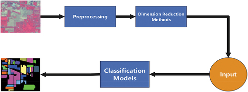
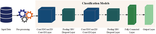
Due to the significant role of artificial Earth satellites in capturing and acquiring Earth image data globally, imaging technology has evolved into a dependable tool for studying Earth information. In traditional imaging methods, distinctions in optical properties are often discerned through the grayscale levels of black-and-white images. Hyperspectral imaging technology integrates spectral technology with imaging techniques to capture high-resolution image data. Initially, hyperspectral imaging technology was manifested as an airborne imaging spectrometer. Through continuous technological refinement, it has evolved into Advanced Visible and Infrared Imaging Spectrometers (AVIRIS) – many benchmark academic hyperspectral datasets now originate from this spectrometer. The general framework for Hyperspectral Image (HSI) processing is illustrated in .
Figure 1. Common frameworks for HSIs processing.
Hyperspectral remote sensing images have garnered considerable attention due to their high spectral resolution, numerous bands, and the capability to precisely delineate spectral characteristic curves of target objects. The progression of imaging technology is pivotal in endowing Hyperspectral Images (HSIs) with their inherent advantages. The advantage of rich spectral information in HSIs enables them to analyze the target scene effectively. Therefore, HSIs have been widely employed in various fields, including pathological diagnosis (Aboughaleb, Aref, and El-Sharkawy Citation2020; Goto et al. Citation2015; Vo-Dinh Citation2004), fruit decay detection (Min et al. Citation2023; Delia et al. Citation2013; Huang et al. Citation2016), wheat seed variety recognition and classification (Bao et al. Citation2019; Que et al. Citation2023; Zhao et al. Citation2022), egg freshness detection (Chen et al. Citation2023; Dai et al. Citation2020; Yao et al. Citation2020), Earth monitoring (Camps-Valls et al. Citation2014; Transon et al. Citation2018), and land cover classification (Hegde et al. Citation2014; Hemanth, Prasad, and Bruce Citation2010; Kwan et al. Citation2020; Priyadarshini et al. Citation2019; Stavrakoudis et al. Citation2012; Zomer, Trabucco, and Ustin Citation2009). Simultaneously, hyperspectral imaging is instrumental in acquiring detailed data for Land Use and Land Cover (LULC) analysis through remote sensing. Specialized remote sensing instruments like satellite imaging and airborne platforms obtain LULC hyperspectral images. This technology facilitates the classification of different land cover types and land use patterns, contributing to a comprehensive understanding of environmental dynamics and resource management. So, LULC hyperspectral image classification has been a particularly active study area. Numerous reviews (Chen et al. Citation2018; Kuras et al. Citation2021; Moharram and Meena Sundaram Citation2023; Vali, Comai, and Matteucci Citation2020) on LULC hyperspectral image classification have recently been published.
In terms of HSI classification, standard classifiers like K-Nearest Neighbor (KNN) and Support Vector Machine (SVM) do not perform well in processing hyperspectral images. On one hand, traditional classification methods fail to account for the abundant spatial information inherent in HSIs, resulting in inadequate feature extraction. On the other hand, most traditional classification methods focus on manual features and require a large amount of manual discrimination and annotation, significantly consuming manpower and time. These factors all contribute to the poor performance of traditional classification methods in classifying hyperspectral images. This has led to the exploration of new, precise classification techniques for hyperspectral image classification. Nowadays, machine learning methods, including advanced Deep Learning (DL) techniques, are widely employed for HSI classification techniques, and the classification performance has dramatically improved compared to previous technologies (Tao et al. Citation2023; Zhong et al. Citation2017).
The LULC can be broadly categorized into two major domains: land cover and land use (Masoumi and van Genderen Citation2023). Land cover pertains to the existing natural and human factors on Earth’s surface, constituting objects that form a covering. This encompasses the natural states of the Earth’s surface, such as forests, grasslands, farmland, soil, and roads. On the other hand, land use refers to the process of transforming the natural ecosystem of land into an artificial ecosystem – a comprehensive process influenced by natural, economic, and social factors. Examples include areas designated for transportation, commerce, residential use, and so forth. Hyperspectral images serve as valuable tools for extracting surface cover features in the context of land use/land cover classification. Furthermore, they facilitate ongoing monitoring of surface cover, enabling a comprehensive understanding of the land’s status and changes. This, in turn, empowers individuals to make optimized and targeted judgments for corresponding maintenance and processing. In the early stages of research on LULC spectral image classification, while many of these classification methods may not have excelled due to their age, they nonetheless demonstrated commendable classification results for their time. These early methods provided valuable insights that contributed to the evolution and improvement of subsequent classification techniques.
In (de Jong et al. Citation2001), the authors introduced the Spatial and Spectral Classifier (SSC) tailored for open natural land cover areas in the Mediterranean region. The SSC integrates the strengths of classification approaches that leverage both spectral and adjacent pixel context information. The SSC method initiates by partitioning HSIs into heterogeneous and homogeneous segments based on spectral changes within the kernel of pixels. Subsequently, a traditional per-pixel method is employed to classify homogeneous segments, while a combination of spectral information and adjacent pixel contextual details is utilized to classify heterogeneous components. Comparative analysis with other classification methods outlined in the article reveals an enhanced overall accuracy with the SSC method. Notably, the SSC method demonstrates proficiency in recognizing mixed pixels within the image, effectively assigning these mixed pixels to appropriate land cover categories. Nevertheless, a limitation of this method exists. Specifically, if the spatial pattern of land cover does not align with the pixel size of the sensors employed and the kernel size used in the analysis, the layering process may encounter impediments, hindering seamless progression. In order to classify multi-source remote sensing and geographic datasets, Gislason et al. (Citation2006) conducted an extensive study on the application domains of random forest classifiers in land cover classification, comparing their accuracy with other well-known ensemble methods. The experimental results highlighted the notable advantages of the random forest classifier. Firstly, in contrast to other ensemble methods, random forest classifiers demonstrated quicker training times without succumbing to overfitting or requiring external guidance. Secondly, the algorithm’s ability to estimate variable importance in classification proved valuable for feature extraction and weighting in remote sensing data classification. Lastly, the random forest algorithm showed proficiency in outlier detection, aiding in avoiding erroneous labeling in certain scenarios. Shao and Lunetta (Citation2012) assessed the classification performance of SVM for spectral images. They compared SVM with two traditional image classification methods – multi-layer perceptron Neural Network (NN) and Classification Regression Tree (CART) – using Medium Resolution Imaging Spectrometer (MODIS) time series data as input. Classification experiments focused on three crucial factors: the size of training samples, changes in training samples, and the impact of reference data point features. The experimental findings underscored that, in comparison to NN and CART methods, SVM achieved higher overall accuracy within a general training sample size range and significantly improved the Kappa coefficient. Moreover, SVM demonstrated superior generalization ability.
Over the past decade, owing to the relentless advancements in machine learning, the classification technology for land use/land cover HSIs has undergone continuous enhancement. Numerous classification methods documented in the relevant literature have demonstrated promising results. Carranza-García et al. (Citation2019) employed a universal convolutional neural network with a fixed structure and parameterization to achieve high accuracy in LULC classification. They also introduced a validation program to compare their method with other traditional classifiers, including random forests, SVM, and KNN. After testing, the results demonstrated that the convolutional neural network exhibited superior performance. Tan and Xue (Citation2022) proposed a new spectral, spatial multi-layer perceptron architecture. This architecture extracts more discriminative features and effectively fuses heterogeneous spatial and spectral features for joint land cover classification. Compared with traditional deep learning classification methods, it has better classification performance. Yang et al. (Citation2023) proposed a partially supervised deep reinforcement learning model to select hyperspectral bands, which exhibits better performance compared to other similar band selection methods. Furthermore, this method was utilized to select the most significant band in the spectral range, and the chosen spectral band exhibited a well-distributed profile across the dynamic range of the spectrum. As a result, the processed band aligns closely with the original hyperspectral data.
1.1. Paper main contribution
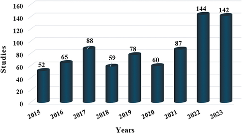
We observed a significant surge in publications after thoroughly examining recent literature on land use/land cover hyperspectral image classification. illustrates this trend, showcasing the latest Scopus-indexed works in the field. Our review evaluates both traditional machine learning models and some emerging technologies, particularly deep learning and spectral unmixing, providing a broader perspective. Despite the existing challenges highlighted in the literature, this surge in research activity has inspired us to collate and present this review. Our goal is to assist researchers in navigating and overcoming these prevalent challenges.
Figure 2. The number of recently published studies in the field of LULC using HSIs.
The contributions of this study are outlined as follows:
The review concentrates solely on the LULC HSI obtained by remote sensing instruments. Unlike broader hyperspectral classifications, our study provides a focused exploration into the specific domains of land cover and land use patterns within hyperspectral imagery. This focused approach enhances our understanding and application potential in environmental dynamics and resource management.
We describe the developmental trends and related challenges of hyperspectral image classification methods, elaborating on the relevant information of hyperspectral image classification and dimensionality reduction methods. Additionally, we summarize some challenges in dimensionality reduction techniques to help researchers gain a deeper understanding of the relevant knowledge in this field.
To enhance the comprehensiveness of this review, we synthesize a series of in-depth studies on the classification of land use/land cover hyperspectral data using traditional machine learning models, deep learning, and spectral unmixing. In summary, this review provides potential guidelines for future research work.
By searching for relevant literature on LULC classification, this review analyzes the advantages and limitations of traditional machine learning models and some promising technologies such as deep learning and spectral unmixing. The aim of this review is to assist researchers in the field of LULC classification in better understanding the performance of various advanced classification methods, aiding in the selection of the most effective classification method, and ultimately providing suggestions for the future direction of LULC classification.
Table 1. Relevant information on the review of land cover/land use hyperspectral image classification in recent years.
provides a detailed comparison of five pivotal review articles in HSI classification, highlighting available datasets, core analyses, and identified limitations within these studies. The distinct strengths of our review, setting it apart from these existing works, are as follows:
Extensive dataset compilation: Our review uniquely assembles 12 diverse remote sensing datasets. We provide not only their detailed parameters but also accessible links for each, thereby offering an unprecedented resource for researchers.
In-depth methodological analysis: We delve deeply into dimensionality reduction and classification techniques, providing a thorough exploration of these critical aspects in HSI classification.
Comprehensive technological scope: In addition to discussing the two common learning methods of traditional machine learning models and deep learning, our review also covers a series of cutting-edge technologies such as spectral unmixing and transformer technology. This breadth ensures a more holistic and complete understanding of the current and potential advancements in the field.
These enhancements underscore our commitment to delivering a review that is not only comprehensive but also practical and forward-looking, aiming to contribute significantly to the research community in hyperspectral image classification.
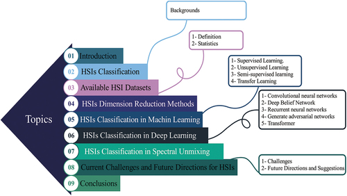
The subsequent sections of the paper are structured as follows: Section 2 examines the background of hyperspectral image classification. Section 3 provides insights into the definition and statistics of available datasets. Section 4 introduces the pertinent background, advantages, and limitations of hyperspectral dimensionality reduction methods. Section 5 and Section 6 respectively discuss the background, advantages, and limitations of traditional machine learning models (supervised, unsupervised, semi-supervised, and transfer learning) and deep learning (CNN, Deep Belief Network (DBN), Recurrent Neural Network (RNN), Generative Adversarial Network (GAN), and transformer) in hyperspectral classification. Additionally, Section 7 introduces the auxiliary technology of hyperspectral image classification – spectral unmixing technology and discusses its background, advantages, and limitations. Section 8 articulates the future development direction of hyperspectral technology, and finally, Section 9 consolidates the main conclusions and suggests potential avenues for further research. The overall structure diagram of this study is shown in .
Figure 3. Review directory.
2. HSIs classification: backgrounds
2.1. Backgrounds
The classification technology of HSIs found broad applications in various fields, including breast cancer screening (Li et al. Citation2022), potato late blight detection (Qi et al. Citation2023), Mengdingshan green tea detection (Zou et al. Citation2023), and crop classification (Hsieh and Kiang Citation2020). Hyperspectral image classification aims to predict and recognize the features of target objects to assist humans in observation and computational analysis.
Over the past decade, HSI classification technology has made significant strides, overcoming various challenges and enhancing processing outcomes. In 2001, Du and Chang introduced a novel discriminant analysis technique, Linear Constraint Distance Analysis (LCDA), which improved upon Fisher’s Linear Discriminant Analysis (LDA) (Du and Chang Citation2001). LCDA uniquely constrains the class center along an orthogonal direction, ensuring separation between all interested classes. This constraint mechanism makes LCDA particularly adept at detecting and classifying similar target information in HSIs with very high spatial resolution. Additionally, LCDA’s versatility allows its extension to unsupervised patterns in scenarios where prior feature knowledge is unavailable. This study (Senthil Kumar et al. Citation2010) proposed a spectral matching method that combines the Variable Interval Spectral Average (VISA) method with the Spectral Curve Matching (SCM) method. This hybrid technique capitalizes on the strengths of both methods: it enables multi-resolution analysis of spectral features and improves digital correlation in the least squares fitting model. The combined approach shows superior performance in classifying both pure and mixed-class pixels, outperforming other methods. Moreover, Du et al. (Citation2012) designed an adaptive binary tree SVM classifier, which incorporated inter-class separability measures with SVM criteria for hyperspectral data (Du, Tan, and Xing Citation2012). This classifier demonstrated enhanced performance compared to other multi-class SVM classifiers and traditional classification methods, showcasing its effectiveness in hyperspectral data analysis.
Recent advancements in deep learning have significantly propelled the field of HSI classification, yielding more precise and effective methods. Sellami et al. (Citation2020) introduced spatial classification methods utilizing spectral band clustering and a three-dimensional (3-D) CNN, including a fused 3-D CNN model (Sellami et al. Citation2020). These methods effectively navigate the challenges of high-dimensional feature space, numerous spectral bands, and limited labeled samples in HSIs. The model excels in extracting deep spectral and spatial features from clusters of similar spectral bands, efficiently mitigating redundancy. By employing spectral clustering to pinpoint the most discriminative and informative spectral bands, it achieves higher classification rates than other methods. The use of 3-D CNN further allows the simultaneous capture of spatial and spectral information, enhancing overall classification performance.
In (Wang, Li, and Zhang Citation2021), a Discriminative Graph Convolutional Network (DGCN) was developed to combat the challenges of intra-class diversity and inter-class similarity in HSI classification. DGCN integrates intra-class and inter-class scattering concepts into GCNs, optimizing feature extraction for enhanced discriminative power. By maximizing inter-class distances and minimizing intra-class distances, DGCN effectively separates different classes, leading to improved classification accuracy. Additionally, to further refine HSI classification, a Multi-Level Graph Learning Network (MGLN) was proposed (Wan et al. Citation2022). This network incorporates global contextual information into local convolutional operations, adaptively learning the graph’s structure to optimize both representation learning and graph reconstruction. MGLN captures contextual information at multiple levels during the graph convolution process, offering a more comprehensive solution than local GCN models by combining local spatial correlation with global image region correlations.
Addressing the limitations of traditional models and low classification accuracy in scenarios with scarce labeled samples, Wang et al. introduced the Capsule Vector Neural Network (CVNN). CVNN combines vector neuron capsule representation with a Vanilla Full Convolutional Network (FCN), enhancing classification methods and accuracy (Wang, Tan, et al. Citation2023). Particularly effective in situations with limited training samples, CVNN manages a balance between retaining secondary features and minimizing salt and pepper noise, demonstrating its efficiency in deep learning modeling. These developments represent the dynamic evolution of HSI classification, with deep learning technologies continually pushing the boundaries of accuracy and efficiency in the field.
The advancement of traditional machine learning models and advanced machine learning (deep learning) algorithms has significantly optimized the field of HSI classification. Despite these improvements, the pursuit of enhanced classification accuracy remains a pressing and dynamic area of research. Inherent limitations within HSIs, such as high dimensionality, spectral variability, and limited labeled samples, continue to pose challenges to classification accuracy. lists the specific information of above mentioned hyperspectral classification studies.
Table 2. Specific introduction to literature related to hyperspectral image classification.
3. Available HSI datasets: definition and statistics
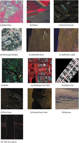
This review identified pertinent datasets from 20 literature sources, encompassing widely used datasets like Indian Pines, Pavia Center, Pavia University, and KSC, alongside several specialized datasets. Subsequently, the collected datasets will undergo definition interpretation and data statistics. We also visualized the pseudo-color maps of all the statistically analyzed hyperspectral datasets, allowing readers to more intuitively understand the overall contours of these datasets, as shown in .
Figure 4. Pseudo-color visualization of all hyperspectral datasets.
3.1. Definitions of the existing datasets
Indian Pines: This dataset was captured by an AVIRIS in Indiana, USA, in 1992, and was intercepted and labeled with a size of 145 × 145, which was used as an early hyperspectral image classification dataset. The Indian Pines dataset has a spatial resolution of approximately 20 m and has 220 spectral bands, of which 20 are noise bands affected by water absorption. In the actual training process, the actual band used is 200. In addition, the Indian Pines dataset contains 16 categories of ground objects, including Alfalfa, Corn-notill, Corn-mintill, Corn, Grass-pasture, Grass-trees, Grass-pasture-mowed, Hay-windrowed, Oats, Soybean-notill, Soybean-mintill, Soybean-clean, Wheat, Woods, Buildings-Grass-Trees-Drives, and Stone-Steel-Towers.
Salinas: This dataset was captured by AVIRIS sensors in the Salinas Valley region of California. The size of the dataset is 512 × 217, with a spatial resolution of 3.7 m and containing 224 spectral bands. Like the IP dataset, there are also 20 water absorption bands, and the actual bands used for training are 204. The SA dataset has 16 categories of ground objects, including Brocoli_green_weeds_1, Brocoli_green_weeds_2, Fallow, Fallow_rough_plow, Fallow_smooth, Stubble, Celery, Grapes_untrained, Soil_vinyard_develop, Corn_senesced_green_weeds, Lettuce_romaine_4wk, Lettuce_romaine_5wk, Lettuce_romaine_6wk, Lettuce_romaine_7wk, Vinyard_untrained, and Vinyard_vertical_trellis.
Pavia University: In 2003, images were obtained by a German airborne Reflectance Optical Spectrometer (ROSIS) while flying over the city of Pavia in northern Italy. The Pavia University and Pavia Center datasets were both acquired during flights over Pavia, northern Italy, but the two datasets are not identical. The Pavia University dataset has a size of 610 × 340 and a spatial resolution of 1.3 m. The PU uses 103 spectral bands for training. There are a total of 9 ground object categories in the PU, which are Asphalt, Meadows, Gravel, Trees, Painted metal sheets, Bare Soil, Bitumen, Self-Blocking Bricks, and Shadows.
Mississippi Gulfport: This dataset was collected in November 2010 at the University of Southern Mississippi Gulf Park Campus. The original Mississippi Gulfport dataset contains 325 × 337 pixels and has 72 bands. However, due to noise and the presence of an invalid area in the lower right corner of the original image, the resulting cropped image size is 325 × 220, with 64 remaining bands. The Mississippi Gulfport dataset has 11 land-cover categories, including Trees, Grass ground surface, Mixed ground surface, Dirt and sand, Road, Water, Buildings, Shadow of buildings, Sidewalk, Yellow curb, and Cloth panels.
HyRANK dataset: Obtained by Hyperion sensor. The spatial resolution of the HyRANK dataset is 30 m. The two hyperspectral datasets used for training in the HyRANK dataset are Dioni and Loukia, respectively. Both images have 176 spectral bands and 14 ground object categories. However, the sizes of the two images are not consistent. The Dioni image size is 250 × 1376, and the Loukia image size is 249 × 945. Among them, the categories are Dense urban fabric, Mineral extraction site, Non-irrigated arable land, Fruit trees, Olive groves, Broad-leaved forest, Coniferous forest, Mixed forest, Dense sclerophyllous vegetation, Sparse sclerophyllous vegetation, Sparsely vegetated areas, Rocks and sand, Water, and Coastal water.
Berlin: A dataset obtained by HyMap sensors over the city of Berlin. The spectral range of the Berlin dataset is from 0.4 to 2.5 μm. The pixel size of this dataset is 300 × 300, and it has 114 bands. The spatial resolution of this dataset is 3.5 m, and it has 5 categories, namely Vegetation, Build-up, Impervious, Soil, and Water.
Washington DC Mall: An aerial HSI obtained by Hydice sensors over the Washington shopping center. The spectral range of the Washington DC Mall dataset is from 0.4 to 2.4 μm. The pixel size of this dataset is 1208 × 307, and it has 191 bands. The spatial resolution of this dataset is 1.5 m, and it has 7 categories, namely Road, Grass, Water, Trail, Trees, Shadow, and Roofs.
Quebec City: A dataset collected by Hyper-Cam LWIR over Quebec City. The spectral range of the Quebec City dataset is from 7.8 to 12.5 μm. The pixel size of this dataset is 795 × 564, and it has 84 bands. The spatial resolution of this dataset is 1 m, and it has 6 categories, namely Road, Gray roof, Trees, Vegetation, Blue roof, and Concrete roof.
Pavia Center: The acquisition method is consistent with Pavia University. However, the pixel size, number of bands, and category names of the two are different. The size of the Pavia Center dataset is 1096 × 715, but Wang’s paper experiment uses 481 × 291. The band of the Pavia Center dataset is 102. The ground category in the Pavia Center dataset includes Water, Trees, Asphalt, Self-Blocking Bricks, and Bitumen, Tiles, Shadows, Meadows, and Bare Soil. The specific differences between these two datasets can be distinguished in detail by viewing the Pavia Centre and University in the relevant dataset link in .
KSC dataset: This dataset was imaged at the Kennedy Space Center in Florida, USA, in 1996. It was also captured using the AVIRIS infrared imaging spectrometer, and a 512 × 614 pixel section was intercepted and labeled as a hyperspectral dataset. The spatial resolution of the KSC dataset is 18 m. Due to the presence of water absorption bands and low signal-to-noise ratio bands in this dataset, the actual bands used for training are 176. The ground object categories in the KSC dataset are 13, which are Scrub, Willow swamp, Cabbage palm hammock, Cabbage palm/oak hammock, Slash pine, Oak/broadleaf hammock, Hardwood swamp, Graminoid marsh, Spartina marsh, Cattail marsh, Salt marsh, Mud flats, and Water.
Botswana: The Botswana data set was acquired by NASA EO-1 satellite in Botswana’s Okavango Delta in 2001, and its size is 1476 × 256. The spatial resolution of this dataset is about 30 m and it has 242 bands. Due to the presence of many noisy bands in the total band, it uses 145 bands in actual training. There are 14 types of features in this dataset, which are Water, Hippo grass, Floodplain grasses 1, Floodplain grasses 2, Reeds, Riparian, Firescar, island interior, Acacia woodlands, Acacia shrublands, Acacia grasslands, Short mopane, Mixed mopane, and Chalcedony.
WHU Hi LongKou data: This dataset was collected in Longkou Town, Hubei Province, China, in 2018 using hyperspectral imaging sensors on a drone platform. The area studied is an agricultural scene. The acquired hyperspectral image size is 550 × 400, and its spatial resolution is 0.463 m. The WHU-Hi-LongKou dataset has 270 bands and 9 categories, including Corn, Cotton, Sesame, Broad-leaf soybean, Narrow-leaf soybean, Rice, Water, Roads, houses, and Mixed weed.
3.2. Statistics
summarizes the datasets used in different hyperspectral classification studies, their parameters, and links to the datasets.
Table 3. The HSI datasets description and their sources.
4. HSIs dimension reduction methods
While HSI offers a wealth of spectral information, its inherent challenge lies in the excessive number of spectral bands. This not only leads to information redundancy but also escalates computational complexity, potentially undermining classification accuracy. Dimensionality Reduction (DR) methods emerge as a critical solution to this dilemma. They streamline HSIs by curtailing redundancy, thereby enhancing classification performance. Researchers across various HSI applications have embraced DR’s benefits. In winemaking, it aids in predicting the sugar content in grape berries (Silva and Melo-Pinto Citation2021; Silva, Gramaxo Freitas, and Melo-Pinto Citation2023), while in medical diagnostics, it assists in identifying malignant tumors (Lazcano et al. Citation2017; Zheludev et al. Citation2015) and in agriculture, it plays a key role in classifying vegetation and crops (Hidalgo, David, and Caicedo Bravo Citation2021).
Dimensionality reduction, often a preliminary step in processing high-dimensional feature data, branches into two primary techniques: feature extraction (Abd Citation2013; Dalal, Cai, et al. Citation2023; Lu et al. Citation2007) and feature selection (Li et al. Citation2011; Stavrakoudis et al. Citation2010). Feature extraction transforms hyperspectral images into a new feature space, using mathematical approaches to reduce and refine data dimensions. This process retains essential data for target improvement and discards superfluous information. LDA, Principal Component Analysis (PCA), and Singular Value Decomposition (SVD) are prominent methods here. In the realm of deep learning, the Stacked Automatic Encoder (SAE) frequently comes into play for HSI feature extraction, though its need to process numerous features simultaneously can complicate and limit its effectiveness. To address this, Zabalza et al. (Citation2016) introduced segmented SAEs, which simplify the original feature data into smaller segments for independent processing by various SAEs. This strategy reduces complexity and bolsters extraction and classification efficiency. However, its accuracy falters with classes having minimal sample sizes.
Further innovations in DR come from Dalal et al. (Citation2023), who introduced a triumvirate of innovative dimensionality reduction techniques, each methodically designed to refine the complex landscape of HSI data analysis. The first of these, Compression and Reinforced Variation (CRV) (Dalal et al. Citation2022) employs a sophisticated feature selection strategy, adeptly isolating the most critical bands from the HSI spectrum. Building upon this foundation, Improving Distribution Analysis (IDA) (Dalal, Al-qaness, et al. Citation2023) represents an advanced stage of feature extraction, further distilling the data to its most informative essence, thus enhancing classification accuracy. The third method, Enhancing Transformation Reduction (ETR) (Dalal, Cai, et al. Citation2023), masterfully integrates the strengths of both CRV and IDA. This method transcends its precursors in both efficiency and accuracy, showcasing an unparalleled ability to enhance and choose the most informative features and reduce the noise, mixed, and outlier pixels impact while retaining key features. Collectively, these methods – CRV, IDA, and ETR – not only mark a significant leap in the domain of dimensionality reduction but also set a new benchmark in HSI data processing, yielding unprecedented levels of accuracy and performance when compared to other established techniques.
In the realm of HSI, the juxtaposition of feature extraction and feature selection methods in dimensionality reduction offers distinct pathways for enhancing data processing. Feature selection, in particular, aims to distill the most pertinent subset of features from the original dataset, thereby augmenting classification performance by eliminating extraneous features and noise. This technique bifurcates into three primary types: filters, wrappers, and embedded systems.
Elmaizi et al. (Citation2019) proposed a Dimensionality Reduction Method (DRM) utilizing the information gain filter selection. This approach judiciously selects bands with the highest informational content, discarding those that are irrelevant or noisy. While this method demonstrated enhanced classification performance and reduced computational costs in comparative studies on two datasets, its optimal outcomes were confined to the specific image datasets and classifiers used in the research, indicating a potential limitation in broader applicability. Moreover, the CRV is one of the feature selection methods for HSIs and works to reduce the dimension of HSI and normalize its distribution (Dalal et al. Citation2022). The CRV eliminated the issue of noise values and mixed pixels without omitting any outliers. CRV first employs the dilation statistical procedure to narrow the gap between the smallest and largest values. Then, based on these results, CRV selects only the wealthy bands that can aid in HSI classification. The CRV was superior to ten other DR methods in terms of reducing the time required for the calculation and selection of the crucial bands.
Medical hyperspectral imaging also benefits from these advancements. Zhang et al. developed a band selection method for medical HSIs, termed Data Gravitation and Weak Correlation Based Sorting (DGWCR) (Zhang et al. Citation2023). This method effectively clusters signals containing bands and expurgates noisy bands, yielding a frequency band selection characterized by minimal redundancy and maximal discrimination. Despite its superiority over other methods, DGWCR’s precision in identifying the optimal number of bands requires further refinement.
The challenge of handling high-dimensional data in HSIs underscores the criticality of dimensionality reduction technologies in improving classification accuracy. Researchers have been diligently evaluating different dimensionality reduction techniques (Demarchi et al. Citation2014; Khodr and Younes Citation2011), fostering a progressive research landscape. The past decade has seen a proliferation of methods aimed at enhancing overall performance in the HSI domain, each method bringing its unique strengths and limitations. Future research endeavors will inevitably focus on addressing these limitations, propelling the field toward more refined and efficient data processing techniques. compares the performance of different dimensionality reduction methods on remote sensing datasets.
Table 4. Examples of dimensionality reduction literature.
5. HSIs classification using traditional machine learning models
The high-dimensional of hyperspectral remote sensing data is considered a major challenge in image classification. With the continuous advancement of Artificial Intelligence (AI) methods, this problem has been greatly improved due to the advantage of AI being able to handle a considerable amount of big data. Artificial intelligence is mainly composed of machine learning, including deep learning techniques. Machine learning is an advanced learning method that utilizes data to train corresponding models and then uses model predictions. It plays an important role in computer vision (Sánchez et al. Citation2023; Xu and Sun Citation2017), speech recognition (Liu et al. Citation2018), medicine (Gao et al. Citation2023; Urbanos et al. Citation2021), and land use/land cover (Boori et al. Citation2018; Damodaran and Rao Nidamanuri Citation2014; Li et al. Citation2016; Luo et al. Citation2016). The traditional machine learning models were considered early techniques for hyperspectral image classification, primarily divided into supervised, unsupervised, semi-supervised, and transfer learning. For a significant duration in the past, traditional machine learning models played a crucial role in LULC classification, where these algorithms extracted and utilized discriminative features from HSIs to classify LULC. This article aims to provide a summary and detailed exploration of the traditional machine learning methods employed in the literature on LULC classification, including their advantages and disadvantages. However, due to the limitations of traditional machine learning methods, there has been relatively little research on them. The article also introduces HSI classification techniques using traditional machine learning in alternative directions to supplement the existing body of research.
5.1. Supervised learning
Recent advancements in supervised machine learning have significantly enhanced LULC classification. Supervised learning, which involves training a model on labeled data for future predictions, primarily addresses classification and regression tasks. Prominent algorithms in this domain include KNN (Bo, Lu, and Wang Citation2018; Huang et al. Citation2016), decision trees (Pal and Mather Citation2003; Velásquez et al. Citation2017), random forest (Abe, Olugbara, and Marwala Citation2014; Clark Citation2017; Huang and Zhu Citation2013; Li et al. Citation2022), and SVM (Petropoulos et al. Citation2015; Petropoulos, Kalaitzidis, and Prasad Vadrevu Citation2012; Pullanagari et al. Citation2017; Sahithi, Iyyanki, and Giridhar Citation2022; Suresh and Lal Citation2020).
Studies like those by Petropoulos et al. have explored the combination of SVM and Artificial Neural Networks (ANN) in Hyperion HSIs for LULC in the Mediterranean, finding comparable classification accuracies between the two (Petropoulos, Arvanitis, and Sigrimis Citation2012). SVM, known for its effective class separation and low generalization error, tends to outperform ANN under certain conditions. However, both SVM and ANN face limitations in subpixel-level classification, particularly in images with coarse spatial resolution.
Advancements in classifier technology, such as the Rotation-based Object-oriented classification method (RoBOO) proposed by Shah et al. (Citation2016) which combines SVM and KNN, have improved HSI classification diversity and accuracy. While RoBOO demonstrates better performance compared to traditional methods, it incurs higher computational costs.
Superpixel segmentation, widely used in HSI classification, considers each superpixel region uniform but faces challenges when these regions contain different categories. Tu et al. introduced a KNN-based superpixel representation approach, combining superpixel segmentation and domain transform recursive filtering to extract spectral-spatial features (Tu et al. Citation2018). This method shows high classification accuracy, even with limited training samples, but its effectiveness hinges on the quality of segmentation and can be computationally intensive. compares the performance of different supervised learning methods on remote sensing datasets.
Table 5. Examples of supervised learning literature.
Dahiya et al. (Citation2021) analyzed the performance of three supervised classifiers, namely Random Forest (RF), neural network, and minimum distance classifier. They studied the regions of Haryana and parts of Uttar Pradesh, used the Hyperion EO-1 dataset downloaded from the online network platform of the United States Geological Survey’s Earth Probe, and then tested several supervised classifiers. The experimental results revealed that the classification accuracy of neural networks surpassed that of random forests and minimum distance classifiers. This superiority is attributed to the self-learning and improvement capabilities of neural networks, showcasing their effectiveness in LULC change maps using hyperspectral images. However, a well-known drawback of neural networks is their inability to observe the learning process between layers, leading to less explainable output results, potentially impacting the credibility and acceptability of the results.
Hyperspectral data can provide valuable information in many fields, and how to effectively utilize spectral and spatial information in the data has always been a concern for researchers in this field. Tong and Zhang (Citation2022) proposed the Spectral Space Cascaded Multilayer Random Forest (SSCMRF) method for classifying tree species in hyperspectral images. This method employs two classification stages to better utilize and integrate spatial information within superpixels and patches. The incorporation of spectral-spatial information in this approach significantly enhances classification performance. To validate the proposed method’s performance, the experiment utilized hyperspectral data from the Jiepai Forest Farm area of Gaofeng State-owned Forest Farm in Guangxi. The study compared the proposed method against various control technologies, including Extended Attribute Profiles (EAPs), Invariant Attribute Profiles (IAPs), SuperPCA, multiscale SuperPCA (MSuperPCA), 3D-CNN, and the Densely Connected Deep RF (DCDRF). Results indicated that the proposed method not only demonstrated the best classification performance but also exhibited relatively fast convergence speed. However, in the Pavia University (PU) dataset, the overall accuracy and Kappa coefficient of the proposed method were lower than those of the EAP method, suggesting potential areas for further improvement in the method’s performance.
In contemporary classification methods, the assumption that training and testing data share the same categories often results in neglecting unknown categories. Open Set Classification (OSC) addresses this issue by allowing the rejection of unknown categories. However, many current OSC methods face challenges where the feature space of known and unknown categories tends to be consistent, retaining redundant information. To enhance the classification accuracy of OSC, Li et al. (Citation2023) introduced a supervised contrastive learning-based open-set hyperspectral classification framework (OSC-SCL). This framework’s advantage lies in its incorporation of supervised contrastive learning for spectral and spatial feature learning separately, effectively aggregating samples of the same class and distinguishing between unknown and known categories. The framework underwent testing on PU and Houston datasets, with experimental results demonstrating its superior classification performance compared to advanced methods such as Classification-Reconstruction Learning for Open-Set Recognition (CROSR), Multitask Deep Learning Method for the Open World (MDL4OW), and Spectral-Spatial Latent Reconstruction (SSLR). However, it’s worth noting that the training time for the proposed method is relatively long.
In summary, while supervised learning has markedly advanced HSI classification, challenges such as computational burden, dependence on segmentation quality, and the need for distinct spectral features continue to guide ongoing research in this field.
5.2. Unsupervised learning
Unsupervised learning, which involves learning from unlabeled data to discern data distributions or relationships, primarily focuses on clustering and dimensionality reduction. Key algorithms include K-means clustering (Haut et al. Citation2017; Mancini, Frontoni, and Zingaretti Citation2016; Ranjan et al. Citation2017), PCA (Jiang et al. Citation2018; Ye et al. Citation2020), Gaussian Mixture Model (GMM) (Jiang et al. Citation2018; Ye et al. Citation2020), and Self-Supervised Learning (Qin et al. Citation2023; Yang et al. Citation2022), among which self-supervised learning is a popular framework in unsupervised learning and is more widely applied. In scenarios where acquiring labeled data is challenging, unsupervised learning becomes especially valuable. A notable application of GMM is Fauvel et al.‘s nonlinear feature selection algorithm, which selects features by maximizing posterior probability (Fauvel, Zullo, and Ferraty Citation2014). This method, tested on three hyperspectral datasets, demonstrated superior feature selection and classification accuracy over SVM. However, its reliance on statistical analysis demands further research to identify extracted features precisely.
Addressing the need for preserving boundaries in HSIs, Kang et al. introduced PCA-EPF, an edge-preserving feature method. This technique fuses Edge-Preserving Filters (EPFs) obtained under different parameters, enhancing class separability (Kang et al. Citation2017). Tested on three datasets, PCA-EPF showed higher classification accuracy than standard EPF methods, but it requires manual EPF parameter selection, limiting its practical application. On the other hand, for challenges like insufficient training data in HSI classification, a sparse representation framework using a label mutual exclusion dictionary learning algorithm under a sparse representation framework (ME-KSVD) algorithm was developed in (Xie et al. Citation2018). This extension of the K-means algorithm considers intra-class consistency and inter-class mutual exclusion, performing well on diverse sample sizes and achieving higher classification accuracy compared to advanced algorithms. The complexity of this algorithm and its relation to low-rank representations, however, remains an area for further exploration. To improve accuracy and generalization in HSI classification, the PLG-KELM method was proposed by (Chen et al. Citation2021). This approach combines PCA, Local Binary Mode (LBP), Grey Wolf Optimization (GWO), and Kernel Extreme Learning Machine (KELM). Demonstrating superior classification performance and generalization, especially with small sample data, PLG-KELM outperformed methods like BLS, SVM, PCA-CNN, CAE-CNN, and KELM in various datasets. Its limitation lies in lower operational efficiency.
Self-supervised learning represents a distinct branch of unsupervised learning and has gained popularity as a framework, albeit not falling entirely within the unsupervised learning category since it utilizes unlabeled samples. The primary advantage of self-supervised learning lies in its ability to leverage large amounts of unlabeled data, which is often more accessible than labeled data. Furthermore, self-supervised methods eliminate the reliance on manual labeling, mitigating the impact of label errors to some extent. Overall, the performance of self-supervised learning can nearly rival that of supervised learning, providing a significant advantage in addressing various practical problems. Self-supervised learning is typically categorized into generative methods, contrastive methods, and adversarial methods.
Hou et al. (Citation2021) drew inspiration from supervised learning and proposed a hyperspectral imagery classification model based on Self-supervised Contrastive Learning (SSCL). The main concept involves using unlabeled samples to address the challenge of insufficient labeled samples in hyperspectral images. The algorithm comprises two stages. In the first stage, self-supervised learning is employed for pre-training. During this phase, data augmentation is combined with a substantial number of unlabeled samples to construct positive and negative sample pairs, minimizing the distance between positive samples and maximizing the distance between negative samples. Subsequently, the pre-trained model parameters are retained, features are extracted from hyperspectral images for classification, and some labeled samples are used to fine-tune the features. The experiment was conducted on the Salinas, Pavia University, and Botswana datasets, revealing that the proposed method achieved higher overall classification accuracy compared to PCA-EPFs, extended morphological profile (EMP)-SVM (EMP-SVM), 2D-CNNs, Multi-Layer Perceptron (MLP)-CNNs (MLP-CNNs), ResNet50, and a shape-adaptive neighborhood information-based semi-supervised learning (SANI-SSL) methods, with scores of 99.7%, 97.21%, and 97.96%, respectively. Moreover, the proposed method demonstrated greater advantages in scenarios with fewer labeled samples, achieving commendable classification performance. However, it is worth noting that the proposed method exhibited the longest testing time, particularly on the SA dataset, taking 7408.9 seconds. This prolonged duration can be attributed to the incorporation of a large number of unlabeled samples for self-supervised learning.
Supervised-learning based methods are extensively utilized for hyperspectral classification owing to their robust feature extraction capabilities with sufficient labeled samples. However, the associated high cost of acquiring labeled samples poses challenges for practical applications. Addressing the need for hyperspectral classification with fewer labeled samples, Zhao et al. (Citation2022). introduced a contrastive self-supervised learning algorithm. This approach employs specific enhancement modules to generate sample pairs, followed by feature extraction through a Siamese network. The model parameters are then fine-tuned using labeled samples to enhance classification performance. Tested on the PU and Houston 2013 datasets, particularly focusing on scenarios with a limited number of labeled samples, the experiment demonstrated superior classification performance compared to other methods. Notably, the algorithm’s effectiveness relies on a small number of labeled samples to achieve optimal performance, and its network structure might be relatively simple to avoid overfitting with limited labeled samples.
For deep learning to excel in hyperspectral classification, sufficient labeled samples are crucial for training. Liu et al. (Citation2023) proposed a Spectrum Masking-based Self-supervised Learning (SSLSM) method, involving two stages: self-supervised pre-training and fine-tuning. The first stage employs spectral masking methods as an auxiliary task, while the second stage utilizes a cascaded encoder and decoder to extract deep semantic features. To verify the effectiveness of the proposed method, experiments were conducted on the Indian Pines, Pavia University, and Yancheng Wetlands datasets, where the training sets accounted for 5%, 0.8%, and 4% of the total samples, respectively. Nine methods (KNN, RF, HybridSN, PCA-ViT, SSGPN, 3-D Autoencoder and Siamese network (3DAES), Deep Few-shot Learning (DFSL), Deep MultiView Learning (DMVL), and unsupervised Spectrum Motion Feature Learning (SMF-UL)) were used to compare their performance with the proposed method. The experimental results show that the proposed method achieved the best classification performance on these three datasets, with values of 96.52 ± 0.40%, 97.03 ± 0.52%, and 96.70 ± 0.24%, respectively. However, for the time cost experiment, we can see that the proposed method requires a relatively long-time cost, which is 375.40 s, 847.41 s, and 124.62 s, respectively. To improve classification accuracy, the model parameters will also increase accordingly, leading to longer training time. However, due to the two-stage strategy of the proposed method, the training time cost is acceptable.
While many supervised learning methods demonstrate strong classification performance, their efficacy can be compromised in practical scenarios with limited labeled sample data. Liu et al. (Citation2023) proposed a novel unsupervised spatial-spectral hyperspectral classification method (PSSA) addressing scenarios with insufficient labeled sample data. PSSA integrates Entropy Rate Superpixel segmentation (ERS), PCA, and PCA-domain 2D Singular Spectral Analysis (SSA) to enhance feature extraction efficiency. The study assessed three common hyperspectral images (IP, SalinasA, and SA) and five aerial hyperspectral datasets (SC-1, SC-2, SC-3, SC-4, and SC-5). Supervised learning methods (KNN, SVM) and unsupervised learning methods (Spectral Clustering (SC), Nyström Extension Clustering (NEC), and Anchor-based Graph Clustering (AGC)) were employed as comparison benchmarks. Experimental results revealed that the proposed PSSA method demonstrated the best classification performance among unsupervised learning methods. However, in comparison to supervised methods, the overall classification performance of PSSA was not particularly strong, attributed to the absence of prior reference information in unsupervised methods. Nevertheless, unsupervised learning approaches align more closely with practical application requirements. provides a performance comparison of different unsupervised learning methods on remote sensing datasets.
Table 6. Examples of unsupervised learning literature.
Overall, unsupervised learning in HSI classification has made significant strides, offering innovative solutions to challenges posed by unlabeled data and complex image characteristics. However, issues like algorithmic complexity and operational efficiency continue to drive research in this field.
5.3. Semi-supervised learning
Semi-supervised learning aims to train classifiers using a large number of unlabeled samples and a small number of labeled samples to address the challenge of insufficient labeled samples. The main processing scenarios of this method are classification, regression, clustering, and dimensionality reduction. The common algorithms for semi-supervised methods include generative model algorithms, self-training algorithms, and graph theory-based methods, among others. Graph-based classification algorithms are highly valued in semi-supervised classification; they may not fully represent the inherent spatial distribution of data. Wang et al. (Citation2014) introduced a semi-supervised classification method for HSIs known as Spatial Spectral Label Propagation (SS-LPSVM). Experimental tests conducted on four hyperspectral datasets revealed that, in comparison to benchmark algorithms, the proposed SS-LPSVM method attained higher overall and individual category classification accuracy. However, a limitation of the method is its sensitivity to parameters related to spatial maps and spatial spectra, as well as adaptive methods, resulting in relatively prolonged computational times for label allocation. Due to the nonlinear mapping ability of deep learning, methods in this field have gained continuous attention in HSI classification. However, due to the many network parameters involved in deep learning, the training process of these related methods takes a relatively long time. Yi et al. (Citation2018) proposed an HSI classification model based on a semi-supervised generalized learning system (SBLS). This method first obtains the corresponding spectral space representation from the original HSI through hierarchical-guided filtering technology. Then, it combines the class probability structure with a generalized learning model to use many unlabeled samples with limited labeled samples. Finally, the ridge regression approximation method is utilized to calculate connection weights. Experimental tests conducted on three datasets – Indian Pines, Salinas, and Botswana – indicated that, in comparison to deep learning-based methods and traditional classifiers, the proposed method achieved higher classification accuracy, consumed less time, and demonstrated superior overall performance. However, the primary drawbacks of the proposed method include input sensitivity and, when too many nodes are set, increased memory space occupation.
The cross-modal feature learning challenge, specifically whether a limited amount of high-quality data can contribute to tasks related to a large amount of low-quality data, has garnered significant attention in the remote sensing field. Traditional semi-supervised popular alignment methods face limitations in addressing such problems, particularly because collecting hyperspectral data is relatively expensive. Hong et al. (Citation2019) introduced a semi-supervised cross-modal learning framework known as Learnable Popular Alignment (LeMA). This framework directly learns joint graph structures from data and subsequently captures data distribution based on graph labels to identify more accurate decision boundaries. The method underwent testing on three datasets: the University of Houston, Chikusei region, and DFC2018, utilizing two high-performance classifiers, Linear Support Vector Machines (LSVM), and Canonical Correlation Forest (CCF). Experimental results demonstrated that, compared to several state-of-the-art methods, the proposed LeMA method exhibited superior classification performance. Despite its high classification performance, LeMA is constrained by linear modeling methods, and this study lacked consideration of spatial information.
GCN is a widely utilized semi-supervised method known for its superior performance in small-sample environments. Xi et al. (Citation2021) introduced a novel Semi-supervised Graph Prototype Network (SSGPN). Distinguished from GCN, SSGPN incorporates a prototype layer, featuring a distance-based cross-entropy loss function and a time entropy-based regularizer. This layer enhances inter-class distance and intra-class compactness of embedded features, generating more representative prototypes for accurate recognition of diverse land cover categories. Additionally, the network employs graph normalization to expedite convergence. Experimental evaluation on benchmark datasets, IP and PU, demonstrated the superior classification performance of the proposed method compared to other techniques. However, the study did not provide a specific description of the training time required, and the framework may not exhibit the best training time compared to alternative methods.
Due to the limited number of labeled samples in hyperspectral images and the high cost of labeled samples, this problem has always limited the performance of many deep learning methods. Semi-supervised and self-supervised algorithms can effectively address this type of problem. Song et al. (Citation2022). combined self-supervised and semi-supervised methods to design a self-supervised assisted Semi-supervised Residual Network (SSRNet) framework. SSRNet is divided into two branches: self-supervised and semi-supervised. The semi-supervised branch relies on spectral feature shift to introduce hyperspectral data perturbations and improve performance. The self-supervised branch is mainly divided into masking band reconstruction and spectral order prediction, and its specific function is to remember the discriminative features of hyperspectral data. Moreover, compared to many deep learning methods, the proposed framework can better explore unlabeled samples, thereby improving classification accuracy. The author used IP, PU, SA, and Houston 2013 datasets as experimental subjects, and SVM, spectral-spatial LSTM (SSLSTM), Contextual Deep CNN (CDCNN), 3-Dimensional Convolutional Autoencoder (3DCAE), spectral-spatial residual network (SSRN), HybridSN, and Double-branch Multi-attention mechanism network (DBMA) as control groups. The experimental results show that the proposed method achieved the highest classification results on these four datasets, indicating the best classification performance. However, the reason why the proposed method has the highest classification accuracy is mainly because many unlabeled samples are used to improve classification performance, which makes the training time of the proposed method longer.
To address the challenges posed by multiple spectral bands and limited labeled samples in hyperspectral classification, Sellami et al. (Citation2023) proposed a hyperspectral classification method based on unsupervised band selection and Semi-supervised Hypergraph Convolutional Network (SSHCN). Firstly, the advantage of unsupervised band selection methods lies in their ability to automatically select relevant spectral features. Secondly, the advantage of semi-supervised hypergraph convolutional networks lies in their ability to preserve spectral-spatial features and effectively handle high correlations in classification. The method excels in automatically selecting relevant spectral bands, preserving spatial and spectral features, and improving classification performance with fewer labeled samples. Evaluation on real hyperspectral datasets, IP and Houston, demonstrated superior classification performance compared to other methods. However, there were some misclassified pixels in the classification map, and the training time of the proposed method was relatively long compared to alternative methods. provides examples of semi-supervised learning methods.
Table 7. Examples of semi-supervised learning literature.
5.4. Transfer learning
Transfer learning is a branch of machine learning that primarily involves transferring previously learned and trained model parameters to a new model to aid in its training. Since most data exhibits a certain degree of correlation, transfer learning allows the knowledge acquired from the original model to be shared with the new model. This process significantly accelerates and optimizes the learning efficiency of the model, avoiding the need to start training from scratch as is typical for many networks. However, it’s important to note that transfer learning models may have limitations, and in some cases, fine-tuning the network is necessary for new tasks.
Xie et al. (Citation2021) introduced a Superpixel Pooling convolutional neural network (SP-CNN) with transfer learning to address the challenge of limited training samples in hyperspectral image classification. The proposed network consists of three main stages. First, a spectral feature downsampling process is achieved through convolution and pooling operations. Next, the hyperspectral spatial information is explored by combining upsampling and superpixel pooling. Finally, the hyperspectral data of each superpixel is fed into a fully connected neural network. This framework excels in utilizing superpixel pooling to effectively integrate spectral and spatial information, and the incorporation of transfer learning enhances the efficiency of model training. To evaluate the proposed framework’s performance, experiments were conducted on the IP, PU, and SA datasets. Results indicate that, compared to other methods, the proposed method exhibits the highest overall classification accuracy. In various experiments with different labeled samples, the proposed method consistently demonstrates strong classification accuracy, highlighting its ability to handle limited labeled samples effectively. It’s worth noting that the optimization of a large number of parameters in the classification process prolongs the training time. However, the use of transfer learning significantly mitigates this training time. The classification accuracy of the proposed model is notably influenced by the number of superpixels, and determining the optimal number requires experimentation, making it challenging to predefine.
Due to the inadequate ability of CNN methods to obtain nonlocal topological relationships representing the underlying data structures of hyperspectral images, Zhang et al. (Citation2021) developed a Topology and Semantic Information Transmission Network (TSTNet) to address this issue. This network characterizes topological relationships by using graph structures and utilizes graph convolutional networks to handle cross-scene hyperspectral classification problems. The network incorporates Graph Optimal Transfer (GOT) and Maximum Mean Difference (MMD) – based techniques to align topological relationships, assisting in aligning the distribution between the source and target domains of MMD. TSTNet combines CNN and GCN, where CNN effectively merges semantic information and topological structure information by constructing graphs and extracting local spatial features, while GCN captures non-local spatial features. This combination enhances the model’s spatial perception ability. Experimental testing on three cross-scene hyperspectral datasets demonstrated that the proposed method not only reduces domain shift but also enhances the performance of cross-scene hyperspectral classification compared to other methods. However, the inclusion of the SACEConv layer in the proposed method results in more time-consuming data processing, thereby increasing the training time of the network.
To effectively identify and classify different crop categories in hyperspectral data, Hamza et al. (Citation2022). adopted squirrel search optimization with a deep transfer learning-enabled crop classification (SSODTL-CC) to accurately identify crop types in hyperspectral data. The proposed model initially derived a MobileNet with an Adam optimizer for feature extraction. Moreover, the proposed model also adopts the SSO algorithm with a bidirectional LSTM (BiLSTM) model for crop classification. The proposed method was evaluated on two benchmark hyperspectral datasets, demonstrating superior classification accuracy compared to other models. However, it’s noteworthy that there is limited information about the training time for the proposed method in the experimental results, which could impact a comprehensive assessment of the model’s performance.
In hyperspectral classification, there is often a lack of consideration for prior knowledge about land cover categories, especially in the form of textual information. Additionally, existing generalization methods in the field have not effectively addressed the extraction of knowledge from language modalities. To address this gap, (Li et al. Citation2023) proposed a Language-Aware Domain Generalization Network (LDGNet). This network is trained solely on the Source Domain (SD) and then transferred to the Target Domain (TD). The proposed method involves a dual-stream structure consisting of an image encoder and a text encoder to extract both visual and language features. Language features processed by the model are treated as shared semantic spaces across scenes, and alignment between visual and language features is achieved through supervised contrastive learning in the semantic space. Experimental evaluations on three datasets showed that, compared to other methods, the proposed LDGNet achieved the highest classification accuracy. However, it’s worth noting that the proposed method incurs a higher computational cost compared to other methods, primarily attributed to the three-layer converter used as the text encoder in the model. Additional details can be found in .
Table 8. Examples of transfer learning literature.
6. HSIs classification using advanced machine learning (deep learning) models
Deep learning is an advanced machine learning approach that replicates the structure and functionality observed in neural networks of the human brain. It uses multi-level neural networks to learn and extract features from data and uses these features for prediction and decision-making. Deep learning (Zhou et al. Citation2022) plays a vital role in fields such as computer vision, natural language processing, speech recognition, and game development. Deep learning has many advantages over other learning methods, such as handling large-scale and complex data, high accuracy, and the ability to extract features automatically. However, deep learning also has some drawbacks, such as requiring a large amount of data and computational costs for training, high requirements for data quality, and poor interpretability of models. The realm of deep learning encompasses various algorithms, with some of the most common ones being CNN, DBN, RNN, GAN, Transformers, and more. To provide a comprehensive understanding of the performance of these models in HSI classification, this review systematically gathered a significant number of studies on hyperspectral classification based on deep learning. The analysis focused particularly on techniques employed for land cover and land use classification in hyperspectral images. It’s important to note that, due to the specificity of the review’s focus on deep learning techniques for land cover and land use classification, the number of relevant studies retrieved in this particular domain was relatively limited. Consequently, the review extends its coverage to include literature on deep learning-based hyperspectral classification in other application areas to supplement the discussion.
6.1. Convolutional neural networks (CNNs)
CNNs are a type of feedforward neural network that involves convolutional computation and have a deep architecture. The basic structure of convolutional neural networks is composed of several parts, namely the input layer, convolutional layer, pooling layer, activation function layer, and fully connected layer. The traditional CNN structure diagram is shown in . CNNs have many advantages, such as automatic learning of image features, local perception, and processing of large datasets, which can achieve better accuracy and efficiency. Due to these advantages of CNN, convolutional neural network methods are constantly being applied in the field of HSI classification (Cao et al. Citation2018; Kalantar et al. Citation2022; Ramamurthy et al. Citation2020; Xu et al. Citation2019; Zhang et al. Citation2018). On the other hand, convolutional neural networks also have some drawbacks, such as high demand for computing resources, high data demand, and limited interpretability. Typical convolutional neural network models such as 1DCNN, 2DCNN, and 3DCNN have their advantages and disadvantages, and some researchers have combined them to achieve better performance (Ahmad et al. Citation2021; Fırat, Emin Asker, and Hanbay Citation2022).
Figure 5. Structure diagram of traditional convolutional neural networks.
Yang et al. (Citation2018) tackled the challenges of HSI classification by developing four deep-learning models. These models were tested on six HSI datasets, showcasing outstanding performance in comparison to other state-of-the-art methods. However, it’s crucial to acknowledge that the four proposed models have certain limitations. Unlike traditional machine learning methods, these models require a larger number of training samples. CNN in deep learning finds extensive use in classifying unstructured data. This versatile technology not only facilitates the classification of land use/land cover using image data but also enables the recognition of crops. To evaluate the performance of this technology, Bhose and Musander (Citation2019) introduced a CNN method for crop recognition utilizing HSI data. The primary advantage of this method is its proficiency in handling unstructured data and automatically extracting features essential for crop monitoring or land classification. The technology underwent testing on the Indian pine tree dataset and the study area dataset, with experimental results demonstrating that CNN can achieve commendable classification performance in both unstructured and small datasets. However, a limitation of this technology is that only spectral features were employed for classification in this study. It may perform even better if spectral space technology is incorporated or the CNN framework is enhanced. To improve the classification performance of HSIs, Sarker et al. (Citation2020) proposed a new multidimensional convolutional neural network based on regularized singular value decomposition (RSVD-MCNN). The main feature of this model is that it can extract advanced features from low dimensional spaces, and MCNN combines convolution operations of different dimensions, which can better perform complex representation learning. This model was tested on three hyperspectral datasets, and the experimental results showed that this method showed excellent advantages in overall classification accuracy. However, although this design has high accuracy, the training time is very long compared to other methods, which becomes the biggest drawback. Hyperspectral images can effectively distinguish various scenes on the Earth’s surface, but this is a challenging task due to the high dimensionality and rich spectral bands of hyperspectral data. Arun Solomon and Akila Agnes, (Citation2023) proposed a new 3D CNN-based model that can identify the most important spectral and spatial features from image datasets, thereby improving the accuracy of land cover classification; it mainly includes two steps: data preprocessing and classification. This method was tested on two typical hyperspectral datasets, Indian Pine and Pavia University, and the results showed that the proposed method exhibited the highest overall accuracy compared to other state-of-the-art classification methods (KNN, SVM, SAE, and 2DCNN). The limitation of the method used is that band selection needs further improvement, classification accuracy can still be improved, and this method has not been extended to applications with fewer labeled training samples.
Due to the high complexity and redundancy of hyperspectral images, these defects have always limited the performance of hyperspectral image classification. To this end, Yu et al. (Citation2021) proposed a CNN framework (FADCNN) that combines spatial-spectral dense connections and feedback attention mechanisms. This framework applies a feedback attention module, which aims to enhance attention maps and utilize multi-scale spatial information to enhance and expand spatial attention modules. In addition, this framework also utilizes a frequency band attention module to improve computational efficiency and feature representation capabilities. Moreover, to better refine the obtained features, the proposed framework densely integrates and mines spatial-spectral features. Test the proposed framework on the Purdue Indian Pines, Kennedy Space Center, and University of Pavia datasets, comparing nine methods (EPF, Iterative Target-constrained Interfere-ence-minimization Classifier (ITCIMC), MFASR, CNN with deconvolution and hashing method (CNNDH), PCA3-F, PCA5-F, FADC, Bidirectional recurrent neural networks (Bi-RNN), and Res-Net34) to better validate their effectiveness. The experimental results show that the proposed method has the highest overall accuracy on all three datasets, which is partly attributed to the frequency attention module (BA). Moreover, compared with the three methods (PCA3-F, PCA5-F, and feedback attention mechanism (FADC)), the proposed method has a relatively shorter time consumption. However, the average accuracy of the proposed method in the Purdue India Indian Pines dataset is not the highest, and a multiple-feature-based adaptive sparse representation (MFASR) method has the highest average accuracy at 97.20%.
Graph convolutional networks are widely used by researchers due to their powerful representation ability. However, most GCN methods overlook pixel-level spectral spatial features. To address this issue, Ding et al. (Citation2022) proposed a method that combines multi-scale GCN and multi-scale CNN (MFGCN). From a multi-scale GCN perspective, this branch can reduce computational costs and refine the multi-scale spatial features of hyperspectral data. From the multi-scale CNN perspective, this branch can extract local features at the multi-scale pixel level. This method also uses one-dimensional CNN to extract spectral features of superpixels. Finally, connect the two branches to fuse complementary multi-scale features. The method was evaluated on the PU, SA, and Houston 2013 datasets, demonstrating superior classification performance compared to six comparative methods. However, the classification accuracy is influenced by three hyperparameters: superpixel scale, number of epochs, and learning rate. Inappropriate settings can lead to negative effects such as reduced classification accuracy and longer training time.
Traditional convolutional neural networks, which mainly use 2D-CNN for feature extraction, cannot effectively handle the inter-band correlation of hyperspectral data. To overcome the shortcomings of 2D-CNN, Alkhatib et al. (Citation2023) proposed a method of fusing multi-scale 3D-CNN with three branch features, which is called Tri-CNN. This method uses PCA to reduce the dimensionality of the data and then uses 3D-CNN to extract hyperspectral features from different scales. Then, the three branches of multi-scale 3D-CNN are flattened and connected, and finally, the softmax and dropout layers are used to generate classification results. The proposed method was tested on three datasets: PU, SA, and GulfPort, and the experiment used 1% labeled training samples to train the model. The experimental results show that the classification accuracy of the proposed method is superior to the other six comparison methods, and the classification map of the proposed method is closer to the ground truth map of the dataset. The author also conducted experiments on training with labeled samples (1%, 2%, 3%, 4%, and 5%) consistently showed that the proposed method achieved the best classification accuracy. However, it’s worth noting that the method involves a substantial number of training parameters, leading to increased computational complexity. Additionally, the classification accuracy of the proposed method on the GulfPort dataset was relatively lower than that on the PU and SA datasets, suggesting room for improvement. lists a number of studies that employed CNNs.
Table 9. Examples of CNNs literature.
6.2. Deep belief network (DBN)
A deep belief network is a deep learning model composed of multiple stacked restricted Boltzmann machines. Compared with other models, DBN has the advantage of being able to pre-train through unsupervised learning and then fine-tune through supervised learning. DBN can better extract high-level abstract features for some complex feature-learning tasks. Due to the advantages of deep belief networks, many researchers have continuously applied them to the field of HSI classification (Chen, Zhao, and Jia Citation2015; Li et al. Citation2018; Mughees and Tao Citation2018). The structure of the deep belief network is shown in .
Figure 6. Structure diagram of a deep belief network, where H refers to a hidden layer, and V to a visible layer.
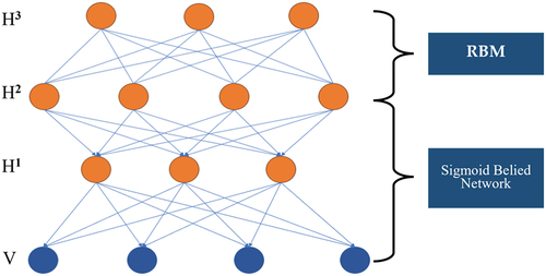
HSIs, characterized by high dimensionality and large data volumes, necessitate extensive computational analysis. Arsa et al. (Citation2016) introduced a Dimensionality Reduction Method (DRM) employing DBNs to enhance hyperspectral image classification. This approach utilizes a two-step DBN process: the first DBN reduces spectral band dimensionality, while the second extracts spectral-spatial features and functions as a classifier. Tested on the Indian Pines hyperspectral dataset, this method outperformed principal component analysis, demonstrating more consistent accuracy. However, the effectiveness of this DRM is heavily influenced by the chosen network depth and other parameters. Determining these optimal values involves extensive searching across combinations, which can lead to considerable computational complexity. Furthermore, the DBN methodology involves unsupervised pre-training on unlabeled samples, followed by supervised fine-tuning on labeled data. This process, while effective, often results in many DBN hidden units exhibiting similar behaviors, potentially impacting the network’s descriptive power and classification accuracy. This factor represents a key area for refinement in the method’s application to hyperspectral image analysis.
Zhong et al. (Citation2017) introduced an innovative diversity DBN model, integrating prior knowledge to boost the diversity of latent factors, significantly enhancing DBN’s performance in HSI classification. Tested on Indian Pines and Pavia University datasets, this method surpassed both the original DBN and several recent HSI classification methods. However, with additional model layers, its performance gains diminish due to the model’s complexity and descriptive capacity. The study’s reliance on a basic diversity-promoting prior hints at potential enhancements through more varied priors, further improving the model’s effectiveness.
In a related development, the evolution of high-resolution optical sensors has revitalized interest in ground object classification using multivariate optical sensors. Li et al. (Citation2019) proposed a novel DBN HSI classification method using multivariate optical sensors and a constrained Boltzmann machine. This approach combines spectral and spatial analysis, with unsupervised pre-training and fine-tuning enabling the DBN model to effectively learn features. A logistic regression layer further refines hyperspectral image classification. Tested on Indian Pines and the University of Pavia datasets, this method outstripped traditional and other deep learning classifications, owing to its deeper network structure and superior feature extraction capabilities. Nevertheless, its drawbacks include low accuracy and slower performance, with the original DBN failing to leverage prior knowledge of training samples, which hampers feature extraction and classification discrimination.
In DBN, each adjacent pair of layers consists of a Restricted Boltzmann Machine (RBM). The training process involves fully training the RBM of the previous layer before moving on to train the RBM of the current layer. This process continues until the last layer. In , there is one visible layer (V) and three hidden layers (H1, H2, and H3). While illustrates three hidden layers, in practice, there can be an arbitrary number of hidden layers in a DBN. Importantly, the last layer (n) and the second-to-last layer (n-1) of the DBN are connected by an undirected graph, while the connections between the other layers are represented by a directed graph. This structure allows DBNs to capture complex hierarchical representations in the data.
Addressing this, Li et al. (Citation2022) proposed the Multi-Deep Belief Network (MMDBN) method to enhance deep and discriminative feature extraction from hyperspectral images. MMDBN not only effectively extracts deep features from each HSI class but also maximizes the margin between categories in a low-dimensional space. Tested on Indian Pines, Salinas, and Botswana datasets, MMDBN demonstrated superior classification performance over several leading methods. However, its primary limitation is the exclusive focus on spectral information, suggesting room for incorporating spatial aspects to further bolster its classification efficacy.
Chen et al. (Citation2020) introduced a novel deep belief network called Conjugate Gradient Updating Algorithm-based Deep Belief Network (CGDBN). The DBN utilized two main steps: unsupervised pre-training and supervised fine-tuning. In the fine-tuning stage, the authors employed the conjugate gradient update algorithm to enhance the convergence speed of DBN. The process involved using spectral features from hyperspectral images as input vectors, computing update variables based on the CG algorithm and 2-norm, and updating parameters during the backpropagation operation in the proposed network. Two variants of CGDBN were explored: one based on the Polak-Ribiere-Polyak (PRF) algorithm and 2-norm DBN (PRP DBN), and the other based on the Fletcher-Reeves (FR) algorithm and 2-norm DBN (FR-DBN). The experimental evaluation, conducted on the PU dataset and the Yellow River Delta coastal wetland dataset, demonstrated that the proposed method achieved significantly higher classification accuracy compared to classical DBN. However, it was noted that the proposed method required more time for training.
To better utilize hyperspectral image information and apply deep confidence networks for land cover, Chintada et al. (Citation2021) proposed a spectral and spatial classification method that relies on deep belief networks. The study focused on testing the proposed method on the PU dataset, and the experimental results demonstrated high classification accuracy. The authors highlighted that DBN serves as a valuable feature extraction technique, particularly in reducing the impact of highlight elements that can affect classification accuracy. However, it’s important to note that the comparison methods employed were not explicitly listed, and the evaluation involved a single accuracy test, limiting the ability to conclusively establish the superiority of the proposed method. Additionally, the dataset used in the study was only one (PU dataset), and while the proposed method showed good performance on this specific dataset, its classification accuracy may vary on other hyperspectral datasets. in the source material provides information on various previous studies that utilized DBNs.
Table 10. Information related to DBN literature.
6.3. Recurrent neural networks (RNNs)
The RNN is a type of neural network designed to handle sequence data. It operates by recursively processing input data in the direction of sequence evolution, where all nodes (loop units) are interconnected in a chain. The structural representation of an RNN is illustrated in . RNN is mainly utilized for processing sequence data and exhibits particular strengths in learning nonlinear features in sequences.
Figure 7. Structure diagram of the recurrent neural network, where X refers to the input, h(t) refers to a hidden state at time t, and L refers to the output. U, V, and W refer to the weights.
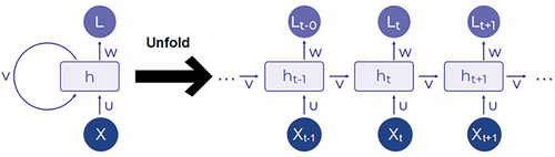
The use of CNNs in processing local features of hyperspectral images has been significant, but CNNs often overlook the spatial dependence between nonadjacent image blocks. RNNs address this by establishing relationships between nonadjacent blocks, but traditionally in one-dimensional sequences. Therefore, Shi and Pun (Citation2018) tackled this limitation by proposing a Multi-Scale Hierarchical Recurrent Neural Network (MHRNN), designed to learn spatial correlations of nonadjacent image blocks in a two-dimensional spatial domain. This method, which considers the local spectral-spatial features of HSIs and captures spatial correlations at various scales, was tested on the Pavia University, Pavia Center, and Salinas datasets. The results showed that MHRNN surpassed several advanced methods like SAE, spectral-spatial feature extraction (SSFC), and MCNN in classification accuracy. However, its downside is increased runtime due to its spatial independent learning approach.
Hang et al. (Citation2019) introduced a cascaded RNN model to enhance feature discrimination in HSIs. It comprises two RNN layers: the first reduces redundancy between adjacent spectral bands, and the second learns complementary information from nonadjacent bands. This model outperformed standalone RNNs but showed slightly lower performance on the Indian Pines dataset, possibly due to the complexity of small objects in the Pavia University dataset. Moreover, Paoletti et al. (Citation2020) developed an RNN model based on the Simple Recurrent Unit (SRU) architecture. This model maintains computational relationships between current and previous states with a decoupled network structure, reducing internal complexity. Tested on four benchmark HSI datasets, it demonstrated high classification accuracy and computational efficiency, though it is prone to overfitting.
Zhou et al. (Citation2021) proposed an RNN method incorporating a multi-scan strategy for HSI classification. This approach transforms local image blocks into complementary directional sequences, enhancing spatial-spectral learning. Tested on IP, PU, and Salinas datasets, this method achieved superior classification performance with fewer parameters. However, it lags in computational efficiency compared to CNN-based methods, despite requiring less training and testing time.
There are two important variants of RNN, namely Long Short-Term Memory (LSTM) and Gated Recurrent Unit (GRU). LSTM is a time-based recurrent neural network used to address vanishing and exploding gradients during long-term sequence training, performing better than conventional RNNs in longer sequences. The GRU model, with reset and update gates, addresses issues in RNN such as the inability to remember long-term information. While similar to LSTM in function, GRU is simpler and easier to train. Both LSTM and GRU are widely used in hyperspectral classification, though there is relatively little literature on hyperspectral classification of land cover and land use.
Gao et al. (Citation2022) proposed a multi-scale dense attention framework (MBDA Net) based on a bidirectional LSTM network (Bi LSTM). The advantage of this framework lies in its Multi-Scale Dense Attention Module (MCDA), which can use different convolutional kernels to obtain multi-scale features, and the Bi LSTM network can also better obtain contextual semantic information. Combine multi-scale features obtained from MCDA with contextual semantic information obtained from Bi LSTM to obtain deeper information. The proposed framework was tested on three datasets: Indian Pines, Pavia University, and Salinas Valley. The experimental results showed that compared with the nine methods, the proposed framework had the highest classification performance in the IP dataset, and its ability in feature mining was also superior to other methods. In datasets with dispersed shapes and positions of PU samples, the classification performance of the proposed method still reaches its optimal state. Finally, on the Salinas Valley dataset, the proposed method demonstrated the highest classification performance across all proportions of training samples. However, the training time of the proposed framework on these three datasets is not the lowest, and it incurs more additional costs than some methods.
To solve the problem of the insufficient ability of convolutional neural networks to extract global spatial information, Xu et al. (Citation2022) proposed a dual branch network consisting of a grouped bidirectional LSTM (GBiLSTM) network and multi-level fused convolutional transformer (MFCT) (GBiLSTM-MFCT). Among them, the GBiLSTM network is used for spectral feature extraction, while the MFCT network is used for spatial feature extraction. The proposed network can divide the sequence features and hidden units of the BiLSTM network into multiple separate groups, and then fuse the extracted features from different groups. DCE and BSCA modules are designed for each stage of the MFCT of the proposed network to improve classification accuracy. Finally, the spectral and spatial features extracted by GBiLSTM and MFCT are fused and classified. The proposed method was tested on the Indian Pines, University of Pavia, and Kennedy Space Center datasets, and the experimental results showed that compared with the eight methods, the overall accuracy, average accuracy, and Kappa coefficient of the proposed method were the highest. This is mainly due to the strong robustness of the MFCT network in feature extraction, and it can use large patches to extract highly discriminative features. Moreover, this network combines spectral features with the GBiLSTM network, resulting in better classification performance. However, the article as a whole focuses on discussing the superiority of the classification accuracy of the proposed method, without discussing or listing relevant information about the training time of the proposed method.
Because hyperspectral images are treated as sequence data, Wu et al. (Citation2023) proposed a three-dimensional softmax mechanism-guided bidirectional GRU network (TDS BiGRU). The bidirectional GRU module of this network can efficiently process sequential data, thereby reducing processing time. In addition, the three-dimensional softmax mechanism of this network uses three branches to capture cross-dimensional interactions and calculate the weight of softmax, to obtain deeper features with stronger discriminative power. The performance of the proposed method is verified through four hyperspectral datasets and six methods, The experimental results show that the classification performance of the proposed methods is the most outstanding. Moreover, the classification results of the proposed method are clearer and more able to demonstrate smoother local area classification than some comparative methods. In addition, the proposed method is better able to focus on the richest and most useful features. However, the relevant table in the literature does not describe of the training time of the proposed method, we cannot determine whether the proposed method also has excellent performance in terms of training time.
To solve the complexity problem caused by the high dimensionality and rich spectral-spatial information of hyperspectral data, Ablin and Prabin (Citation2023) proposed a lightweight convolutional neural network integrating random forest and gated recurrent units (Light CERG Network). The proposed method can use the Adaptive Mutation Quantum Inspired Squirrel Search Algorithm (AM-QSSA) to select compact and distinct feature subsets, thereby improving the processing of land cover categories for spectral features. In addition, this network uses random forests, deep learning, lightweight CNNs, and gated recurrent units to construct a Stacking architecture for HSI classification, which takes prior information as input variables. To minimize overfitting, the proposed method utilizes cross-validation to create inputs and iterates to the classifier in the second stage. The proposed method was tested on three datasets, and the experimental results showed that with the increase of training samples, the classification performance of the proposed method reached the best state, and it has the maximum recognition effect. However, the proposed method still needs to utilize more datasets and samples to validate its effectiveness and applicability. Moreover, lists several RNN studies.
Table 11. Examples of RNN literature.
6.4. Generate adversarial networks (GAN)
GAN is a generative model that learns by playing games between two neural networks. It can observe the distribution of many samples and simultaneously generate more equally distributed samples. In the basic GAN framework, there are two networks, namely the generator model and the discriminator model, which not only train simultaneously but also compete with each other. A generator is used to generate new images, while a discriminator is used to distinguish between true and false images. The generated adversarial network structure diagram is shown in .
Figure 8. Structure diagram of GAN.
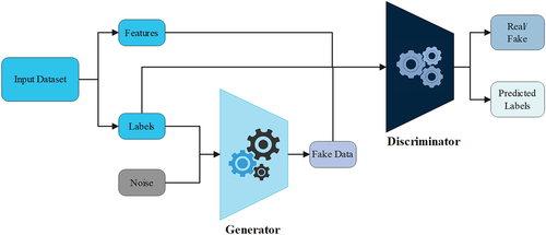
The use of GAN models for HSI classification has been explored, but the original single-discriminator GAN model faces issues like pattern collapse and limited diversity. To address this, Gao et al. (Citation2019) proposed a Multi-Discriminator Generative Adversarial Network (MDGAN). Their findings show that this approach not only stabilizes the training process compared to the original GAN but also significantly improves sample quality and classification performance of HSIs. Additionally, MDGAN shows enhanced classification accuracy over traditional methods like CNN and SVM. However, it also increases training time and requires further improvement in spatial feature extraction.
Another challenge in HSI classification is the limited number of training samples and the quality of labeled data. Addressing this, Zhao et al. (Citation2019) introduced a Cluster-based Conditional Generative Adversarial Network (CCGAN). This method excels in automatically identifying key features for sample generation and uses conditional GAN to generate realistic samples. Tested on the Pavia hyperspectral dataset, CCGAN markedly outperformed traditional classification methods. A drawback, however, is noise generation during sample creation, which can impact classification accuracy.
In land cover classification using deep learning, the need for extensive training data to achieve high accuracy is well-acknowledged. Ansith et al. (Citation2021) developed an improved GAN architecture for land use classification, leveraging deep learning’s capability for automatic feature extraction and thus reducing manual intervention. Tested on the UC Merced land use dataset, this method proved to be faster and more efficient than other deep learning approaches, offering a promising solution in the field.
Deep learning methods have shown promising results in HSI data classification, yet challenges remain, such as the scarcity of HSI data for complex scenarios and improving accuracy with limited samples. To address these issues, Chen et al. (Citation2022) developed a novel classification architecture, JAGAN, which integrates a channel space joint attention mechanism with generative adversarial networks. Tested on a complex land cover dataset using GF-5 AHSI images, JAGAN achieved the highest overall classification accuracy compared to other methods. It particularly improved classification accuracy in regions characterized by limited samples and complex features. However, JAGAN has its limitations. While it surpasses 3D-CNN and other methods in overall accuracy (OA), it falls slightly behind 3D-CNN in specific categories. The incorporation of attention mechanisms, while beneficial for accuracy, also results in longer training and testing times compared to methods like 3D-CNN, presenting a trade-off between accuracy and efficiency.
GAN models stand out in deep learning for their ability to perform effectively with limited datasets, and not heavily reliant on extensive training samples for maintaining classification performance. However, the accuracy of these models, while commendable, is not optimal and leaves room for improvement to further enhance precision.
Liang et al. (Citation2021) proposed a semi-supervised spectral-spatial attention feature extraction method based on GAN (SSAT-GAN), which mainly feeds data into deep learning model frameworks in an end-to-end manner. The first step of this method is to process the unlabeled data, which is fed into the discriminator to solve the problem of insufficient training samples. Meanwhile, utilizing adversarial training to provide reconstructed hyperspectral data distribution. The Spectral Spatial Attention Module (SSAT) in this method can effectively extract discriminative features, and this module can also effectively improve the discriminative power of feature representations. In addition, the unsupervised learning of the proposed method adopts an average minimization loss to avoid the collapse of GAN. Test the proposed method on IP, PU, and KSC datasets and compare it with 10 different methods. The experimental results show that the proposed method has better classification performance on all three datasets, and has a more uniform region, which means it can effectively suppress information that is not conducive to classification. In addition, the KSC dataset has relatively sparse features, which makes it difficult for traditional networks to interpret its spectral-spatial features. The excellent performance of the proposed method on KSC fully demonstrates its ability to achieve better robustness in terms of sparsity. However, GAN-based methods require alternating optimization of the discriminator and generator, resulting in a relatively long training time, and the proposed method is no exception.
Generative adversarial networks have attracted much attention due to their ability to effectively solve the problem of limited training samples in hyperspectral image classification. However, there is a problem of class imbalance in hyperspectral images, and GAN always associates a few class samples with false labels. To address this issue, He et al. (Citation2022) proposed a semi-supervised generative adversarial network called HyperViTGAN that includes Transformers. The semi-supervised classifier in this design can avoid contradictions in the discriminator’s handling of classification and discrimination tasks. Using skip-connected generators and discriminators for adversarial learning to generate hyperspectral blocks. Moreover, the proposed network can effectively capture relevant information, thereby reducing the loss of critical information. In addition, the proposed network can improve its generalization and stability through data augmentation. Test the proposed method on three publicly available hyperspectral datasets and compare it with nine different methods. The experimental results indicate that the proposed model has more advantages in classification performance. However, compared to the running time of other methods, the proposed method has a relatively longer running time.
To effectively process the spectral information of hyperspectral data and alleviate the problem of insufficient training samples for hyperspectral images, Hao, Xia, and Ye (Citation2023) proposed a Transformer with residual upscale GAN framework (TRUG) with a transformer. GAN can generate fake images similar to real data to alleviate the problem of insufficient training samples. In the generator, Residual Upscale (RU) can improve image resolution and generate high-quality samples. In the discriminator, the Transformer module is adopted, and the self-attention mechanism is used in the first layer to extract features and classify them. This framework was tested on two publicly available hyperspectral datasets using 10% of the training set, and several comparative methods were used to validate the proposed method. The experimental results show that the proposed method has the best classification performance on the IP dataset, but only the OA and Kappa coefficients are the highest on the PU dataset. Although the proposed method has good classification performance, it performs better than ordinary GAN methods. However, this does not mean that the proposed method is the best performing, as it has not been compared with more models related to hyperspectral classification. summarizes several GAN-based studies.
Table 12. Examples of GAN literature.
6.5. Transformer-based models
Transformer is a sequence model based on the attention mechanism. Compared to traditional RNNs and CNNs, the transformer model only uses a self-attention mechanism to process the input sequence and output sequence. Due to this feature, the Transformer model can be calculated in parallel, greatly improving the computational efficiency. The transformer model mainly consists of two parts: an encoder and a decoder. The Transformer structure diagram is shown in .
Figure 9. Structure diagram of transformer.
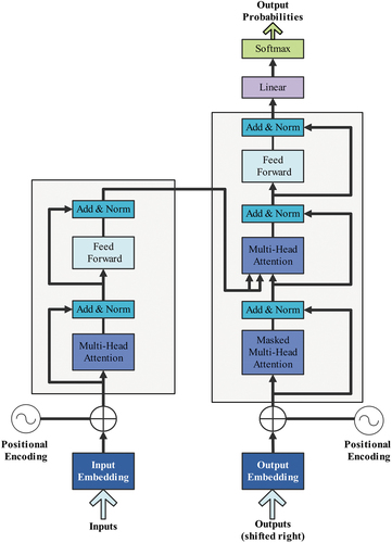
Deep learning has been pivotal in HSI classification, yet challenges persist, such as spectral information loss and limited extraction of continuous spectral features. The Transformer model, known for learning long-range relationships, offers a solution. The following studies highlight the evolving landscape of deep learning in HSI classification, showcasing the potential of Transformer models in addressing existing limitations and opening avenues for future research in large-scale and multimodal applications.
Ayas and Tunc-Gormus (Citation2022) introduced a spectral-swin transformer network that processes spatial and spectral features simultaneously. The network, when compared with various methods (KNN, RF, SVM, 1D/2D-CNN, RNN, miniGCN, ViT, SpectralFormer) on Indian Pines and Pavia University datasets, demonstrated superior performance. However, further improvements in classification performance are needed, particularly by integrating visual transformers in the network. Wang et al. (Citation2022) proposed a novel spectral space kernel with an improved visual transformer (ViT) to enhance spectral space feature extraction. This approach, combining PCA for dimensionality reduction and a heavy attention mechanism with local-global information utilization in the transformer, displayed superior urban land, crop, and mineral classification performance on four datasets. The high network complexity, however, somewhat limits its classification efficiency.
Zhang et al. (Citation2023) tackled the challenge of incomplete spectral-spatial feature extraction in HSIs with TransHSI, combining 3D CNN with a Transformer module for spectral features, and 2D CNN with a Transformer for spatial features. The method, tested against 11 algorithms on three datasets, achieved the highest overall accuracy and Kappa coefficient. Nonetheless, reducing network complexity to enhance performance remains a task for future research. Yao et al. (Citation2023) addressed the scalability issue in Transformer-based methods for remote sensing with their ExViT framework, adept at leveraging both modality-specific and cross-modal information. Tested on Houston 2013 and Berlin datasets, ExViT outperformed transformer and CNN-based models, although more diverse multimodal remote sensing datasets are needed for further validation. Wang et al. (Citation2023) introduced the SCSTIN, a spatial convolutional spectral transformer interaction network integrating 2D-CNN and Transformer into a dual-branch network for enhanced feature extraction. The network, tested on the ZY1-02D hyperspectral dataset, achieved high accuracy and efficiency, outperforming eight advanced classifiers. However, its application to large-scale hyperspectral refined land cover classification remains unexplored.
Convolutional neural networks are widely employed in hyperspectral image classification, offering excellent capabilities for local context modeling. However, CNNs may struggle to effectively explore and represent the sequential attributes of spectral features. In contrast, the Transformer model stands out for its proficiency in characterizing global sequence attributes. Hong et al. (Citation2021) introduced a transformer-based backbone network named SpectralFormer, emphasizing the extraction of spectral information. The proposed network excels at learning local spectral sequence features from hyperspectral images, enhancing the generation of grouped spectral embeddings. In addition, to mitigate the loss of important information during the hierarchical propagation process, SpectralFormer incorporates a cross-layer skip connection. This connection’s primary function is to adaptively learn and fuse “soft” residuals across layers, facilitating the transfer of components from shallow to deep layers. Experimental evaluations on the IP, PU, and Houston 2013 datasets, compared against eight existing methods, demonstrate that the proposed method achieves the best classification performance, surpassing the classical Transformer. However, it is crucial to address the relatively high overall network complexity of the proposed method and appropriately reduce it while ensuring minimal impact on classification accuracy.
Although CNN has a strong ability to extract local information, it also has many limitations. For example, it is difficult for CNN to capture contextual spectral-spatial features from long-range spectral-spatial relationships. Due to the large number of labeled samples, deep learning-based methods have particularly good performance, which is very time-consuming and expensive. To address these issues, Zhao et al. (Citation2023) proposed a hyperspectral classification framework based on Multiple Attention Transformers (MAT) and active learning based on adaptive superpixel segmentation (MAT-ASSAL). Firstly, use Transformer’s self-attention module to model long-range contextual dependencies in spectral space, and use Outlook’s attention module to obtain local features. Then, use MAT-ASSAL to select important samples for MAT to train a better model. Finally, an adaptive superpixel segmentation algorithm is adopted to incorporate irregular spatial similarity into active learning. This experiment tested the MAT and MAT-ASSAL methods on PU, Houston 2013, and Yellow River Estuary datasets, and compared them with 9 methods (SVM, 3D-CNN, HybridSN, a HSIC framework based on the encoder of Transformer (HSI-BERT), double-branch dual-attention mechanism network (DBDA (Mish)), attention-based adaptive spectral – spatial kernel improved residual network (A2S2K-ResNet), Superpixel Graph Learning (SGL), adaptive superpixel segmentation algorithm active learning (SSAL), and feature-oriented adversarial active learning (FAAL)). The experimental results show that the MAT-ASSAL method has the highest classification accuracy. However, MAT-ASSAL has not been tested on more datasets, and its generalization ability still needs further validation and improvement. Additionally, summarizes several studies that used Transformer architecture.
Table 13. Examples of transformer literature.
7. HSIs classification using spectral unmixing
Due to the spatial resolution limitation of remote sensing images, a single pixel in the image generally has multiple ground feature types, which affects the classification accuracy of the image. The main function of mixed spectral unmixing technology is to analyze spectral data, that is, to determine the proportion of different components within the same pixel and identify the additional components beyond the known component analysis. This technology model is divided into linear mixed spectral unmixing model and nonlinear mixed spectral unmixing model, of which linear spectral unmixing is more widely used.
The challenge of mixed pixels, resulting from low spatial resolution in HSI classification, significantly hampers the performance by blending multiple land cover types within a single pixel. Villa et al. (Citation2010) addressed this issue by combining soft classification techniques and spectral unmixing algorithms to determine fractional abundances. Additionally, they employed a simulated annealing algorithm for spatial regularization, enhancing the accuracy of land cover categorization within each pixel. Tested on three datasets, this method notably surpassed traditional classification techniques in scenes with mixed pixels. However, there’s a need for further research to more effectively differentiate between pure and mixed pixels. On the other hand, the intersection of spectral unmixing and classification algorithms in HSI analysis, a less explored area, was tackled by Villa et al. (Citation2011). They proposed a semi-supervised algorithm that merges a discriminative classifier with linear spectral unmixing. Testing on simulated and real hyperspectral datasets indicated promising performance, but the method requires validation on additional datasets for broader verification.
Dópido et al. (Citation2012) explored feature extraction in HSI processing, incorporating spectral unmixing technology as a novel strategy. They developed a technique that integrates unsupervised clustering and partial spectral unmixing for both spatial and spectral information extraction. When tested on four hyperspectral images, this approach yielded physically significant components from a spatial perspective, achieving robust classification accuracy. Nonetheless, the study was limited to linear feature extraction methods, omitting nonlinear approaches. Moreover, Dópido et al. (Citation2014) introduced a novel semi-supervised hybrid strategy that synergizes spectral unmixing and classification. This approach uniquely integrates a polynomial logistic regression classifier with various spectral unmixing chains, effectively bridging the gap between these two areas. To assess its efficacy, the method was applied to the IP and PU datasets, demonstrating commendable classification accuracy. However, its performance needs validation on larger datasets, and its applicability in practical scenarios remains untested.
In the context of biodiversity conservation and ecosystem monitoring, accurate generation of vegetation maps from remote sensing images is crucial. Mixed pixels pose a challenge in extracting reliable information, and spectral unmixing technology offers a viable solution. Ibarrola-Ulzurrun et al. (Citation2019) evaluated different spectral unmixing models in a complex mountain ecosystem with high spectral variation. Their approach categorized experiments into robust and non-robust endmembers, performing endmember variability analysis and measuring performance using root mean square error reconstruction and classification maps derived from abundance maps. The results indicated that spectral unmixing models accounting for spectral variability yield more accurate classification maps and mitigate the curse of dimensionality in hyperspectral data. However, the study lacked a comprehensive analysis of spectral variation.
Vibhute et al. (Citation2021) highlighted the significance of extracting spectral features from HSIs for land classification. Testing various endmember, demixing, and classification algorithms on HSIs, they found that the least squares linear demixing method achieved an accuracy of 94.19%, outperforming other methods in feature imaging. Yet, this study also suggests a need for more nuanced consideration of mixed pixel challenges in the classification process. These research efforts collectively underscore the potential and limitations of integrating spectral unmixing with classification approaches in hyperspectral image analysis.
Overall, while spectral unmixing and classification have been widely discussed, strategies effectively combining these two methods are relatively scarce, presenting opportunities for future research in HSI analysis.
8. Current challenges and future directions for hyperspectral images
8.1. Challenges
Due to the inherent deficiencies of HSIs, there are many challenges in LULC HSI classification:
The cost of hyperspectral imaging is very high. Compared to other remote sensing technologies, hyperspectral imaging requires higher costs and more time to collect hyperspectral data. Additionally, hyperspectral imaging requires higher computing power, which is due to the huge amount of hyperspectral data collected by hyperspectral imaging, which requires better storage and processing capabilities.
The limitation of labeled samples in HSIs greatly affects the performance of LULC HSI classification. Moreover, the acquisition of labeled samples in HSIs is also difficult, and the cost of manually labeling samples is high. These issues are factors that affect LULC HSI classification.
Due to the high spectral resolution of HSIs and the high correlation between adjacent bands, there is a high degree of data redundancy in HSI data, as well as the high dimensionality of HSIs themselves, which leads to longer computation time and higher complexity in the HSI processing process, further affecting the performance of LULC HSI classification.
Deep learning models, especially CNNs, which are often used for image analysis, require extensive computational resources. The complexity of these models can be particularly problematic when processing high-resolution HSIs, necessitating high-performance computing infrastructure that may not be readily available or affordable. Although transfer learning is a promising approach to overcome the limitation of scarce labeled data, it often underperforms in the context of HSIs due to the substantial differences in spectral and spatial characteristics between source and target domains.
Many hyperspectral sensors offer limited spatial resolution, which may be insufficient for identifying and distinguishing between land use/land cover types at a detailed level, particularly in heterogeneous landscapes. This can limit the applicability of deep learning models in practical scenarios where fine-grained classifications are essential.
The ability to process hyperspectral data in real-time is crucial for some applications, such as disaster response. However, the computational demands of deep learning models, coupled with the high dimensionality of hyperspectral data, pose significant challenges to real-time deployment.
8.2. Future directions and suggestions
To obtain a more effective and superior LULC classification model, the following aspects should be carefully considered:
Although using hyperspectral imaging can obtain a large amount of spectral and spatial information, hyperspectral imaging is not only expensive but also has very strict and complex collection conditions and preparation work for hyperspectral data. Therefore, developing a low-cost instrument for large-scale scene acquisition and analysis of HSIs is crucial. Future research may focus on developing advanced data fusion techniques that can effectively integrate hyperspectral data with other types of remote sensing data, such as LiDAR or multispectral imagery. This could enhance the classification accuracy by leveraging the complementary information available in different data sources.
According to the collection and comparison of literature on LULC classification using traditional machine learning and deep learning methods, we can see that compared to traditional machine learning methods, deep learning not only has higher performance and accuracy but also requires relatively less computation time. Traditional machine learning is more suitable for scenarios with small data sizes and relatively simple problems, while deep learning is more suitable for scenarios with large-scale data, complex problems, and high-dimensional features. Therefore, deep learning is more suitable for solving the problem of LULC HSI classification. Therefore, in the future, research on LULC classification should focus more on the application of deep learning. Thus, developing more sophisticated deep learning architectures, specifically tailored for hyperspectral data, is a key area of future research. These architectures would aim to efficiently handle the high dimensionality and spectral-spatial characteristics of hyperspectral images.
In recent years, as a type of technology in deep learning, Transformer has been continuously applied by researchers in LULC classification. It has the advantages of parallel computing, capturing global information, interpretability, scalability, processing multimodal data, and good pre-training effect. Compared to some traditional neural networks, it has higher computational efficiency. Therefore, transformer technology is a promising development direction for LULC classification. Thus, transfer learning would allow models trained on one dataset to be effectively applied to another, enhancing their generalizability and applicability.
In addition, previous studies on LULC classification only used one type of information in the spectrum and space for HSI classification. Although the previous studies were promising, the performance of classification could be further improved if the spectral and spatial features were analyzed together. Therefore, future LULC classification research should focus on using spectral and spatial information for experimental testing.
By addressing existing limitations and exploring the aforementioned future direction suggestions, the research community can make a significant contribution to the field of LULC classification using HSI.
9. Conclusions
Classification represents a pivotal aspect of HSI processing, with enhancing its performance constituting a significant research focus within this domain. HSI classification finds applications in diverse fields, with LULC emerging as particularly popular subjects. This paper explored the state-of-the-art methodologies, challenges, and innovations in hyperspectral image classification for LULC applications. First, it identified the available public datasets with their detailed description and characteristics. Then, this review provided a comprehensive overview of the development background of HSI classification, offering a brief introduction to dimensionality reduction techniques and discussing various classification strategies. The review delved into traditional machine learning approaches, encompassing supervised, unsupervised, semi-supervised, and transfer learning methods. Moreover, it explored advanced classification techniques, including deep learning (including CNN, DBN, RNN, GAN, and transformer architectures) and spectral unmixing. The paper also summarized the strengths and weaknesses gleaned from relevant literature on these diverse methodologies. Furthermore, the paper addressed and highlighted the main challenges in LULC hyperspectral image classification. Finally, potential future avenues and directions are highlighted to propose the progression of research in this evolving area.
Disclosure statement
No potential conflict of interest was reported by the author(s).
Data availability statement
This is a review paper. No data was used in this study.
Correction Statement
This article has been corrected with minor changes. These changes do not impact the academic content of the article.
Additional information
Funding
Notes on contributors
Chen Lou
Chen Lou graduated from Zhejiang Normal University Xingzhi College with a Bachelor’s degree in Electronic Information Engineering in 2022. He is currently pursuing a master’s degree in electronic information at the School of Physics and Electronic Information Engineering, Zhejiang Normal University. His research focuses on deep learning, machine learning, and hyperspectral image classification.
Mohammed A. A. Al-qaness
Mohammed A. A. Al-qaness received the B.S., M.S., and Ph.D. degrees from Wuhan University of Technology, in 2010, 2014, and 2017, respectively, all in information and communication engineering.,He was an Assistant Professor with the School of Computer Science, Wuhan University. He was also a Postdoc Researcher at the State Key Laboratory for Information Engineering in Surveying, Mapping, and Remote Sensing, Wuhan University. Now, he is a Professor at College of Physics and Electronic Information Engineering, Zhejiang Normal University. His current research interests include wireless sensing, mobile computing, machine learning, signal and image processing, and natural language processing
Dalal AL-Alimi
Dalal AL-Alimi received M.S. degree and Ph.D. degree from the University of Geosciences, Wuhan, China in 2020 and 2023 respectively. Her research interests include remote sensing images, image processing, object detection, image classification, hyperspectral images, deep learning, machine learning, and time series forecasting.
Abdelghani Dahou
Abdelghani Dahou received a B.S. degree in computer science and intelligent systems from the University of Ahmad Draia, Adrar, Algeria in 2012, and an M.S. degree in computer science and intelligent systems from University of Ahmad Draia, Adrar, Algeria in 2014. He graduated in 2019 with a Ph.D. degree in computer science at Wuhan University of Technology, Wuhan, Hubei, China. He is currently an assistant professor at University of Ahmad Draia, Adrar, Algeria. His research interests lie in the general area of machine learning, particularly in deep learning, neural architecture search and Neuro Evolution, as well as their applications in opinion mining, text classification, multitask and meta-learning, and Arabic natural language processing.
Mohamed Abd Elaziz
Mohamed Abd Elaziz received the B.S. and M.S. degrees in Computer science from the Zagazig University, in 2008 and 2011, respectively. He received Ph.D. degree in mathematics and computer science from Zagazig University, Egypt in 2014. From 2008 to 2011, he was Assistant lecturer in Department of computer science. He is associate professor at Zagazig university, Egypt. He is the author of more than 170 articles. His research interests include metaheuristic technique, security IoT, cloud computing machine learning, signal processing, image processing, and evolutionary algorithms.
Laith Abualigah
Laith Abualigah received the degree in computer information system and the master’s degree in computer science from Al Al-Bayt University, Jordan, in 2011 and 2014, respectively, and the Ph.D. degree from the School of Computer Science, Universiti Sains Malaysia (USM), Malaysia, in 2018. He is currently an Associate Professor with the Prince Hussein Bin Abdullah College for Information Technology, Al Al-Bayt University. His research interests include arithmetic optimization algorithm (AOA), bio-inspired computing, nature-inspired computing, swarm intelligence, artificial intelligence, meta-heuristic modeling, optimization algorithms, evolutionary computations, information retrieval, text clustering, feature selection, combinatorial problems, optimization, advanced machine learning, big data, and natural language processing.
Ahmed A. Ewees
Ahmed A. Ewees received the Ph.D. degree from Damietta University, Egypt, in 2012. He is currently an Associate Professor of computer science with Damietta University. He co-supervises the master’s and Ph.D. students and leads and supervises various graduation projects. He has published many scientific research papers in international journals and conferences. His research interests include machine learning, artificial intelligence, text mining, natural language processing, image processing, and metaheuristic optimization techniques.
References
- Abd, H. A. A.-R. 2013. “Feature Extraction and Based Pixel Classification for Estimation the Land Cover Thematic Map Using Hyperspectral Data.” The Land 3 (3).
- Abe, B. T., O. O. Olugbara, and T. Marwala. 2014. “Experimental Comparison of Support Vector Machines with Random Forests for Hyperspectral Image Land Cover Classification.” Journal of Earth System Science 123: 779–790.
- Ablin, R., and G. Prabin. 2023. “An Optimal Model Using Hybrid LCNN-GRU for Efficient Hyperspectral Image Classification.” International Journal of Information Technology 15 (6): 3335–3342.
- Aboughaleb, I. H., M. H. Aref, and Y. H. El-Sharkawy. 2020. “Hyperspectral Imaging for Diagnosis and Detection of ex-Vivo Breast Cancer.” Photodiagnosis and Photodynamic Therapy 31: 101922.
- Ahmad, M., S. Shabbir, R. Aamir Raza, M. Mazzara, S. Distefano, and A. M. Khan. 2021. “Artifacts of Different Dimension Reduction Methods on Hybrid CNN Feature Hierarchy for Hyperspectral Image Classification.” Optik 246: 167757. https://doi.org/10.1016/j.ijleo.2021.167757.
- Akbari, D., S. Homayouni, A. Safari, and N. Mehrshad. 2016. “Mapping Urban Land Cover Based on Spatial-Spectral Classification of Hyperspectral Remote-Sensing Data.” International Journal of Remote Sensing 37 (2): 440–454.
- Alkhatib, M. Q., M. Al-Saad, N. Aburaed, S. Almansoori, J. Zabalza, S. Marshall, and H. Al-Ahmad. 2023. “Tri-CNN: A Three Branch Model for Hyperspectral Image Classification.” Remote Sensing 15 (2): 316.
- Ansith, S., and A. A. Bini. 2021. “A Modified Generative Adversarial Network (GAN) Architecture for Land Use Classification.” In 2021 IEEE Madras Section Conference (MASCON), Chennai, India, 27-28 August 2021.
- Arsa, D. M. S., G. Jati, A. J. Mantau, and I. Wasito. 2016. “Dimensionality Reduction Using Deep Belief Network in Big Data Case Study: Hyperspectral Image Classification.” In 2016 International Workshop on Big Data and Information Security (IWBIS), Jakarta, Indonesia, 18-19 October 2016.
- Arun Solomon, A., and S. Akila Agnes. 2023. “Land-Cover Classification with Hyperspectral Remote Sensing Image Using CNN and Spectral Band Selection.” Remote Sensing Applications: Society & Environment 31: 100986. https://doi.org/10.1016/j.rsase.2023.100986.
- Ayas, S., and E. Tunc-Gormus. 2022. “SpectralSWIN: A Spectral-Swin Transformer Network for Hyperspectral Image Classification.” International Journal of Remote Sensing 43 (11): 4025–4044.
- Bao, Y., C. Mi, N. Wu, F. Liu, and Y. He. 2019. “Rapid Classification of Wheat Grain Varieties Using Hyperspectral Imaging and Chemometrics.” Applied Sciences 9 (19): 4119.
- Bera, S., V. K. Shrivastava, and S. Chandra Satapathy. 2022. “Advances in Hyperspectral Image Classification Based on Convolutional Neural Networks: A Review.” Cmes-Computer Modeling in Engineering & Sciences 133 (2).
- Bhosle, K., and V. Musande. 2019. “Evaluation of Deep Learning CNN Model for Land Use Land Cover Classification and Crop Identification Using Hyperspectral Remote Sensing Images.” The Journal of the Indian Society of Remote Sensing 47 (11): 1949–1958.
- Bo, C., H. Lu, and D. Wang. 2018. “Spectral-Spatial K-Nearest Neighbor Approach for Hyperspectral Image Classification.” Multimedia Tools & Applications 77: 10419–10436.
- Boori, M. S., R. Paringer, K. Choudhary, A. Kupriyanov, and R. Banda. 2018. “Land Cover Classification and Build Spectral Library from Hyperspectral and Multi-Spectral Satellite Data: A Data Comparison Study in Samara, Russia.” In CEUR Workshop Proceedings.
- Camps-Valls, G., D. Tuia, L. Bruzzone, and J. Atli Benediktsson. 2014. “Advances in Hyperspectral Image Classification: Earth Monitoring with Statistical Learning Methods.” IEEE Signal Processing Magazine 31 (1): 45–54. https://doi.org/10.1109/MSP.2013.2279179.
- Cao, Q., Y. Zhong, A. Ma, and L. Zhang. 2018. “Urban Land Use/Land Cover Classification Based on Feature Fusion Fusing Hyperspectral Image and Lidar Data.” In IGARSS 2018 - 2018 IEEE International Geoscience and Remote Sensing Symposium, Valencia, Spain, 22-27 July 2018.
- Carranza-García, M., J. García-Gutiérrez, and J. C. Riquelme. 2019. “A Framework for Evaluating Land Use and Land Cover Classification Using Convolutional Neural Networks.” Remote Sensing 11 (3): 274. https://doi.org/10.3390/rs11030274.
- Chen, C., Y. Ma, and G. Ren. 2020. “Hyperspectral Classification Using Deep Belief Networks Based on Conjugate Gradient Update and Pixel-Centric Spectral Block Features.” IEEE Journal of Selected Topics in Applied Earth Observations & Remote Sensing 13: 4060–4069.
- Chen, H., F. Miao, Y. Chen, Y. Xiong, and T. Chen. 2021. “A Hyperspectral Image Classification Method Using Multifeature Vectors and Optimized KELM.” IEEE Journal of Selected Topics in Applied Earth Observations & Remote Sensing 14: 2781–2795.
- Chen, S.-Y., S.-H. Hsu, C.-Y. Ko, and K.-H. Hsu. 2023. “Real-Time Defect and Freshness Inspection on Chicken Eggs Using Hyperspectral Imaging.” Food Control 150: 109716. https://doi.org/10.1016/j.foodcont.2023.109716.
- Chen, W., X. Li, H. He, and L. Wang. 2018. “A Review of Fine-Scale Land Use and Land Cover Classification in Open-Pit Mining Areas by Remote Sensing Techniques.” Remote Sensing 10 (1): 15. https://doi.org/10.3390/rs10010015.
- Chen, W., S. Ouyang, J. Yang, X. Li, G. Zhou, and L. Wang. 2022. “JAGAN: A Framework for Complex Land Cover Classification Using Gaofen-5 AHSI Images.” IEEE Journal of Selected Topics in Applied Earth Observations & Remote Sensing 15: 1591–1603.
- Chen, Y., X. Zhao, and X. Jia. 2015. “Spectral–Spatial Classification of Hyperspectral Data Based on Deep Belief Network.” IEEE Journal of Selected Topics in Applied Earth Observations & Remote Sensing 8 (6): 2381–2392.
- Chintada, K. R., S. Prakash Yalla, and A. Uriti. 2021. “A Deep Belief Network Based Land Cover Classification.” In 2021 Innovations in Power and Advanced Computing Technologies (i-PACT).
- Christovam, L. E., G. G. Pessoa, M. H. Shimabukuro, and M. L. B. T. Galo. 2019. “Land Use and Land Cover Classification Using Hyperspectral Imagery: Evaluating the Performance of Spectral Angle Mapper, Support Vector Machine and Random Forest.” International Archives of the Photogrammetry, Remote Sensing and Spatial Information Sciences 42: 1841–1847.
- Clark, M. L. 2017. “Comparison of Simulated Hyperspectral HyspIRI and Multispectral Landsat 8 and Sentinel-2 Imagery for Multi-Seasonal, Regional Land-Cover Mapping.” Remote Sensing of Environment 200: 311–325.
- Dahiya, N., S. Gupta, and S. Singh. 2021. “Quantitative Analysis of Different Land-Use and Land-Cover Classifiers Using Hyperspectral Dataset.” In 2021 Sixth International Conference on Image Information Processing (ICIIP).
- Dai, D., T. Jiang, W. Lu, X. Shen, R. Xiu, and J. Zhang. 2020. “Nondestructive Detection for Egg Freshness Based on Hyperspectral Scattering Image Combined with Ensemble Learning.” Sensors 20 (19): 5484.
- Dalal, A.-A., M. A. Al-qaness, Z. Cai, and E. Ahmed Alawamy. 2023. “IDA: Improving Distribution Analysis for Reducing Data Complexity and Dimensionality in Hyperspectral Images.” Pattern Recognition 134: 109096.
- Dalal, A.-A., Z. Cai, M. A. Al-qaness, E. Ahmed Alawamy, and A. Alalimi. 2023. “ETR: Enhancing Transformation Reduction for Reducing Dimensionality and Classification Complexity in Hyperspectral Images.” Expert Systems with Applications 213: 118971.
- Dalal, A.-A., Z. Cai, M. A. Al-qaness, A. Dahou, E. Ahmed Alawamy, and S. Issaka. 2022. “Compression and Reinforce Variation with Convolutional Neural Networks for Hyperspectral Image Classification.” Applied Soft Computing 130: 109650.
- Damodaran, B. B., and R. Rao Nidamanuri. 2014. “Assessment of the Impact of Dimensionality Reduction Methods on Information Classes and Classifiers for Hyperspectral Image Classification by Multiple Classifier System.” Advances in Space Research 53 (12): 1720–1734. https://doi.org/10.1016/j.asr.2013.11.027.
- de Jong, M. S, T. Hornstra, and H.-G. Maas. 2001. “An Integrated Spatial and Spectral Approach to the Classification of Mediterranean Land Cover Types: The SSC Method.” International Journal of Applied Earth Observation and Geoinformation 3 (2): 176–183. https://doi.org/10.1016/S0303-2434(01)85009-1.
- Delia, L., A. S. José Blasco, E. Soria-Olivas, N. Aleixos, and J. Gómez-Sanchís. 2013. “Comparison of ROC Feature Selection Method for the Detection of Decay in Citrus Fruit Using Hyperspectral Images.” Food and Bioprocess Technology 6: 3613–3619.
- Demarchi, L., F. Canters, C. Cariou, G. Licciardi, and J. Cheung-Wai Chan. 2014. “Assessing the Performance of Two Unsupervised Dimensionality Reduction Techniques on Hyperspectral APEX Data for High Resolution Urban Land-Cover Mapping.” Isprs Journal of Photogrammetry & Remote Sensing 87: 166–179.
- Ding, Y., Z. Zhang, X. Zhao, D. Hong, W. Cai, C. Yu, N. Yang, and W. Cai. 2022. “Multi-Feature Fusion: Graph Neural Network and CNN Combining for Hyperspectral Image Classification.” Neurocomputing 501: 246–257.
- Dopido, I., J. Li, P. Gamba, and A. Plaza. 2014. “A New Hybrid Strategy Combining Semisupervised Classification and Unmixing of Hyperspectral Data.” IEEE Journal of Selected Topics in Applied Earth Observations & Remote Sensing 7 (8): 3619–3629.
- Dópido, I., A. Villa, A. Plaza, and P. Gamba. 2012. “A Quantitative and Comparative Assessment of Unmixing-Based Feature Extraction Techniques for Hyperspectral Image Classification.” IEEE Journal of Selected Topics in Applied Earth Observations & Remote Sensing 5 (2): 421–435.
- Du, Q., and C. I. Chang. 2001. “A Linear Constrained Distance-Based Discriminant Analysis for Hyperspectral Image Classification.” Pattern Recognition 34 (2): 361–373. https://doi.org/10.1016/S0031-3203(99)00215-0.
- Du, P., K. Tan, and X. Xing. 2012. “A Novel Binary Tree Support Vector Machine for Hyperspectral Remote Sensing Image Classification.” Optics Communications 285 (13): 3054–3060. https://doi.org/10.1016/j.optcom.2012.02.092.
- Elmaizi, A., H. Nhaila, E. Sarhrouni, A. Hammouch, and C. Nacir. 2019. “A Novel Information Gain Based Approach for Classification and Dimensionality Reduction of Hyperspectral Images.” Procedia Computer Science 148: 126–134. https://doi.org/10.1016/j.procs.2019.01.016.
- Fauvel, M., A. Zullo, and F. Ferraty. 2014. “Nonlinear Parsimonious Feature Selection for the Classification of Hyperspectral Images.” In 2014 6th Workshop on Hyperspectral Image and Signal Processing: Evolution in Remote Sensing (WHISPERS).
- Fırat, H., M. Emin Asker, and D. Hanbay. 2022. “Classification of Hyperspectral Remote Sensing Images Using Different Dimension Reduction Methods with 3D/2D CNN.” Remote Sensing Applications: Society & Environment 25: 100694. https://doi.org/10.1016/j.rsase.2022.100694.
- Gao, J., X. Gao, N. Wu, and H. Yang. 2022. “Bi-Directional LSTM with Multi-Scale Dense Attention Mechanism for Hyperspectral Image Classification.” Multimedia Tools & Applications 81 (17): 24003–24020.
- Gao, H., M. Wang, X. Sun, X. Cao, C. Li, Q. Liu, and P. Xu. 2023. “Unsupervised Dimensionality Reduction of Medical Hyperspectral Imagery in Tensor Space.” Computer Methods and Programs in Biomedicine 240: 107724. https://doi.org/10.1016/j.cmpb.2023.107724.
- Gao, H., D. Yao, M. Wang, C. Li, H. Liu, Z. Hua, and J. Wang. 2019. “A Hyperspectral Image Classification Method Based on Multi-Discriminator Generative Adversarial Networks.” Sensors 19 (15): 3269.
- Gislason, P. O., J. Atli Benediktsson, and J. R. Sveinsson. 2006. “Random Forests for Land Cover Classification.” Pattern Recognition Letters 27 (4): 294–300. https://doi.org/10.1016/j.patrec.2005.08.011.
- Goto, A., J. Nishikawa, S. Kiyotoki, M. Nakamura, J. Nishimura, T. Okamoto, H. Ogihara, Y. Fujita, Y. Hamamoto, and I. Sakaida. 2015. “Use of Hyperspectral Imaging Technology to Develop a Diagnostic Support System for Gastric Cancer.” Journal of Biomedical Optics 20 (1): 16017–16017.
- Gu, Y., J. Chanussot, X. Jia, and J. Atli Benediktsson. 2017. “Multiple Kernel Learning for Hyperspectral Image Classification: A Review.” IEEE Transactions on Geoscience & Remote Sensing 55 (11): 6547–6565.
- Hamza, M. A., F. Alrowais, J. S. Alzahrani, H. Mahgoub, N. M. Salem, and R. Marzouk. 2022. “Squirrel Search Optimization with Deep Transfer Learning-Enabled Crop Classification Model on Hyperspectral Remote Sensing Imagery.” Applied Sciences 12 (11): 5650.
- Hang, R., Q. Liu, D. Hong, and P. Ghamisi. 2019. “Cascaded Recurrent Neural Networks for Hyperspectral Image Classification.” IEEE Transactions on Geoscience & Remote Sensing 57 (8): 5384–5394.
- Hao, S., Y. Xia, and Y. Ye. 2023. “Generative Adversarial Network with Transformer for Hyperspectral Image Classification.” In IEEE Geoscience and Remote Sensing Letters.
- Haut, J. M., M. Paoletti, J. Plaza, and A. Plaza. 2017. “Cloud Implementation of the K-Means Algorithm for Hyperspectral Image Analysis.” The Journal of Supercomputing 73: 514–529.
- Hegde, G., J. Mohammed Ahamed, R. Hebbar, and U. Raj. 2014. “Urban Land Cover Classification Using Hyperspectral Data.” International Archives of the Photogrammetry, Remote Sensing and Spatial Information Sciences 40: 751–754.
- Hemanth, K., S. Prasad, and L. M. Bruce. 2010. “Decision-Level Fusion of Spectral Reflectance and Derivative Information for Robust Hyperspectral Land Cover Classification.” IEEE Transactions on Geoscience and Remote Sensing: A Publication of the IEEE Geoscience and Remote Sensing Society 48 (11): 4047–4058. https://doi.org/10.1109/TGRS.2010.2072787.
- He, Z., K. Xia, P. Ghamisi, Y. Hu, S. Fan, and B. Zu. 2022. “Hypervitgan: Semisupervised Generative Adversarial Network with Transformer for Hyperspectral Image Classification.” IEEE Journal of Selected Topics in Applied Earth Observations & Remote Sensing 15: 6053–6068.
- Hidalgo, R., B. B. C. David, and E. Caicedo Bravo. 2021. “Dimensionality Reduction of Hyperspectral Images of Vegetation and Crops Based on Self-Organized Maps.” Information Processing in Agriculture 8 (2): 310–327. https://doi.org/10.1016/j.inpa.2020.07.002.
- Hong, D., Z. Han, J. Yao, L. Gao, B. Zhang, A. Plaza, and J. Chanussot. 2021. “SpectralFormer: Rethinking Hyperspectral Image Classification with Transformers.” IEEE Transactions on Geoscience & Remote Sensing 60: 1–15.
- Hong, D., N. Yokoya, N. Ge, J. Chanussot, and X. Xiang Zhu. 2019. “Learnable Manifold Alignment (LeMA): A Semi-Supervised Cross-Modality Learning Framework for Land Cover and Land Use Classification.” Isprs Journal of Photogrammetry & Remote Sensing 147: 193–205.
- Hou, S., H. Shi, X. Cao, X. Zhang, and L. Jiao. 2021. “Hyperspectral Imagery Classification Based on Contrastive Learning.” IEEE Transactions on Geoscience & Remote Sensing 60: 1–13.
- Hsieh, T.-H., and J.-F. Kiang. 2020. “Comparison of CNN Algorithms on Hyperspectral Image Classification in Agricultural Lands.” Sensors 20 (6): 1734.
- Huang, K., S. Li, X. Kang, and L. Fang. 2016. “Spectral–Spatial Hyperspectral Image Classification Based on KNN.” Sensing and Imaging 17: 1–13.
- Huang, R., and J. Zhu. 2013. “Using Random Forest to Integrate Lidar Data and Hyperspectral Imagery for Land Cover Classification.” In 2013 IEEE International Geoscience and Remote Sensing Symposium - IGARSS, Melbourne, VIC, Australia, 21-26 July 2013.
- Ibarrola-Ulzurrun, E., L. Drumetz, J. Marcello, C. Gonzalo-Martín, and J. Chanussot. 2019. “Hyperspectral Classification Through Unmixing Abundance Maps Addressing Spectral Variability.” IEEE Transactions on Geoscience & Remote Sensing 57 (7): 4775–4788.
- Jiang, J., J. Ma, C. Chen, Z. Wang, Z. Cai, and L. Wang. 2018. “SuperPCA: A Superpixelwise PCA Approach for Unsupervised Feature Extraction of Hyperspectral Imagery.” IEEE Transactions on Geoscience & Remote Sensing 56 (8): 4581–4593.
- Jin, S., W. Zhang, P. Yang, Y. Zheng, J. An, Z. Zhang, P. Qu, and X. Pan. 2022. “Spatial-Spectral Feature Extraction of Hyperspectral Images for Wheat Seed Identification.” Computers & Electrical Engineering 101: 108077.
- Jun, G., and J. Ghosh. 2011. “Spatially Adaptive Classification of Land Cover with Remote Sensing Data.” IEEE Transactions on Geoscience and Remote Sensing: A Publication of the IEEE Geoscience and Remote Sensing Society 49 (7): 2662–2673. https://doi.org/10.1109/TGRS.2011.2105490.
- Kalantar, B., S. Teymoor Seydi, N. Ueda, V. Saeidi, A. Abdul Halin, and F. Shabani. 2022. “Deep Ensemble Learning for Land Cover Classification Based on Hyperspectral Prisma Image.” In IGARSS 2022 - 2022 IEEE International Geoscience and Remote Sensing Symposium, Kuala Lumpur, Malaysia, 17-22 July 2022.
- Kang, X., X. Xiang, S. Li, and J. Atli Benediktsson. 2017. “PCA-Based Edge-Preserving Features for Hyperspectral Image Classification.” IEEE Transactions on Geoscience & Remote Sensing 55 (12): 7140–7151.
- Khodr, J., and R. Younes. 2011. “Dimensionality Reduction on Hyperspectral Images: A Comparative Review Based on Artificial Datas.” In 2011 4th international congress on image and signal processing, Shanghai, China, 15-17 October 2011.
- Kuras, A., M. Brell, J. Rizzi, and I. Burud. 2021. “Hyperspectral and Lidar Data Applied to the Urban Land Cover Machine Learning and Neural-Network-Based Classification: A Review.” Remote Sensing 13 (17): 3393. https://doi.org/10.3390/rs13173393.
- Kwan, C., D. Gribben, B. Ayhan, J. Li, S. Bernabé, and A. Plaza. 2020. “An Accurate Vegetation and Non-Vegetation Differentiation Approach Based on Land Cover Classification.” Remote Sensing 12 (23): 3880. https://doi.org/10.3390/rs12233880.
- Lazcano, R., D. Madroñal, R. Salvador, K. Desnos, M. Pelcat, R. Guerra, H. Fabelo, et al. 2017. “Porting a PCA-Based Hyperspectral Image Dimensionality Reduction Algorithm for Brain Cancer Detection on a Manycore Architecture.” Journal of Systems Architecture 77: 101–111. https://doi.org/10.1016/j.sysarc.2017.05.001.
- Li, B., Y. Liu, H. Xing, Y. Meng, G. Yang, X. Liu, and Y. Zhao. 2022. “Integrating Urban Morphology and Land Surface Temperature Characteristics for Urban Functional Area Classification.” Geo-Spatial Information Science 25 (2): 337–352.
- Li, C., Y. Wang, X. Zhang, H. Gao, Y. Yang, and J. Wang. 2019. “Deep Belief Network for Spectral–Spatial Classification of Hyperspectral Remote Sensor Data.” Sensors 19 (1): 204.
- Li, G., S. Ma, K. Li, M. Zhou, and L. Lin. 2022. “Band Selection for Heterogeneity Classification of Hyperspectral Transmission Images Based on Multi-Criteria Ranking.” Infrared Physics & Technology 125: 104317.
- Li, J., B. Xi, Y. Li, Q. Du, and K. Wang. 2018. “Hyperspectral Classification Based on Texture Feature Enhancement and Deep Belief Networks.” Remote Sensing 10 (3): 396.
- Li, S., H. Wu, D. Wan, and J. Zhu. 2011. “An Effective Feature Selection Method for Hyperspectral Image Classification Based on Genetic Algorithm and Support Vector Machine.” Knowledge-Based Systems 24 (1): 40–48. https://doi.org/10.1016/j.knosys.2010.07.003.
- Li, S., W. Song, L. Fang, Y. Chen, P. Ghamisi, and J. Atli Benediktsson. 2019. “Deep Learning for Hyperspectral Image Classification: An Overview.” IEEE Transactions on Geoscience & Remote Sensing 57 (9): 6690–6709.
- Li, X., T. Wu, K. Liu, Y. Li, and L. Zhang. 2016. “Evaluation of the Chinese Fine Spatial Resolution Hyperspectral Satellite TianGong-1 in Urban Land-Cover Classification.” Remote Sensing 8 (5): 438. https://doi.org/10.3390/rs8050438.
- Li, Z., K. Bi, Y. Wang, Z. Fang, and J. Zhang. 2023. “Supervised Contrastive Learning for Open-Set Hyperspectral Image Classification.” In IEEE Geoscience and Remote Sensing Letters.
- Li, Z., H. Huang, Z. Zhang, and G. Shi. 2022. “Manifold-Based Multi-Deep Belief Network for Feature Extraction of Hyperspectral Image.” Remote Sensing 14 (6): 1484.
- Liang, H., W. Bao, X. Shen, and X. Zhang. 2021. “Spectral–Spatial Attention Feature Extraction for Hyperspectral Image Classification Based on Generative Adversarial Network.” IEEE Journal of Selected Topics in Applied Earth Observations & Remote Sensing 14: 10017–10032.
- Liu, Q., D. Xue, Y. Tang, Y. Zhao, J. Ren, and H. Sun. 2023. “PSSA: PCA-Domain Superpixelwise Singular Spectral Analysis for Unsupervised Hyperspectral Image Classification.” Remote Sensing 15 (4): 890.
- Liu, Z.-T., M. Wu, W.-H. Cao, J.-W. Mao, J.-P. Xu, and G.-Z. Tan. 2018. “Speech Emotion Recognition Based on Feature Selection and Extreme Learning Machine Decision Tree.” Neurocomputing 273: 271–280. https://doi.org/10.1016/j.neucom.2017.07.050.
- Lu, S., K. Oki, Y. Shimizu, and K. Omasa. 2007. “Comparison Between Several Feature Extraction/Classification Methods for Mapping Complicated Agricultural Land Use Patches Using Airborne Hyperspectral Data.” International Journal of Remote Sensing 28 (5): 963–984.
- Luo, S., C. Wang, X. Xi, H. Zeng, D. Li, S. Xia, and P. Wang. 2016. “Fusion of Airborne Discrete-Return LiDAR and Hyperspectral Data for Land Cover Classification.” Remote Sensing 8 (1): 3. https://doi.org/10.3390/rs8010003.
- Mancini, A., E. Frontoni, and P. Zingaretti. 2016. “A Multi/hyper-Spectral Imaging System for Land Use/Land Cover Using Unmanned Aerial Systems.” In 2016 International Conference on Unmanned Aircraft Systems (ICUAS), Arlington, VA, USA, 07-10 June 2016.
- Masoumi, Z., and J. van Genderen. 2023. “Artificial Intelligence for Sustainable Development of Smart Cities and Urban Land-Use Management.” Geo-Spatial Information Science 1–25.
- Min, D., J. Zhao, G. Bodner, M. Ali, F. Li, X. Zhang, and B. Rewald. 2023. “Early Decay Detection in Fruit by Hyperspectral Imaging–Principles and Application Potential.” Food Control 152: 109830. https://doi.org/10.1016/j.foodcont.2023.109830.
- Moharram, M. A., and D. Meena Sundaram. 2023. “Dimensionality Reduction Strategies for Land Use Land Cover Classification Based on Airborne Hyperspectral Imagery: A Survey.” Environmental Science and Pollution Research 30 (3): 5580–5602.
- Mughees, A., and L. Tao. 2018. “Multiple Deep-Belief-Network-Based Spectral-Spatial Classification of Hyperspectral Images.” Tsinghua Science and Technology 24 (2): 183–194.
- Pal, M., and P. M. Mather. 2003. “An Assessment of the Effectiveness of Decision Tree Methods for Land Cover Classification.” Remote Sensing of Environment 86 (4): 554–565.
- Paoletti, M. E., J. M. Haut, J. Plaza, and A. Plaza. 2020. “Scalable Recurrent Neural Network for Hyperspectral Image Classification.” The Journal of Supercomputing 76: 8866–8882.
- Petropoulos, G. P., K. Arvanitis, and N. Sigrimis. 2012. “Hyperion Hyperspectral Imagery Analysis Combined with Machine Learning Classifiers for Land Use/Cover Mapping.” Expert Systems with Applications 39 (3): 3800–3809.
- Petropoulos, G. P., C. Kalaitzidis, and K. Prasad Vadrevu. 2012. “Support Vector Machines and Object-Based Classification for Obtaining Land-Use/cover Cartography from Hyperion Hyperspectral Imagery.” Computers & Geosciences 41: 99–107.
- Petropoulos, G. P., D. P. Kalivas, I. A. Georgopoulou, and P. K. Srivastava. 2015. “Urban Vegetation Cover Extraction from Hyperspectral Imagery and Geographic Information System Spatial Analysis Techniques: Case of Athens, Greece.” Journal of Applied Remote Sensing 9 (1): 096088–096088.
- Priyadarshini, K. N., V. Sivashankari, S. Shekhar, and K. Balasubramani. 2019. “Assessment on the Potential of Multispectral and Hyperspectral Datasets for Land Use/Land Cover Classification.” Multidisciplinary Digital Publishing Institute Proceedings 24 (1): 12.
- Pullanagari, R., G. Kereszturi, I. J. Yule, and P. Ghamisi. 2017. “Assessing the Performance of Multiple Spectral–Spatial Features of a Hyperspectral Image for Classification of Urban Land Cover Classes Using Support Vector Machines and Artificial Neural Network.” Journal of Applied Remote Sensing 11 (2): 026009–026009.
- Qi, C., M. Sandroni, J. Cairo Westergaard, E. Høegh Riis Sundmark, M. Bagge, E. Alexandersson, and J. Gao. 2023. “In-Field Classification of the Asymptomatic Biotrophic Phase of Potato Late Blight Based on Deep Learning and Proximal Hyperspectral Imaging.” Computers and Electronics in Agriculture 205: 107585.
- Qin, Y., Y. Ye, Y. Zhao, J. Wu, H. Zhang, K. Cheng, and K. Li. 2023. “Nearest Neighboring Self-Supervised Learning for Hyperspectral Image Classification.” Remote Sensing 15 (6): 1713.
- Que, H., X. Zhao, X. Sun, Q. Zhu, and M. Huang. 2023. “Identification of Wheat Kernel Varieties Based on Hyperspectral Imaging Technology and Grouped Convolutional Neural Network with Feature Intervals.” Infrared Physics & Technology 131: 104653. https://doi.org/10.1016/j.infrared.2023.104653.
- Ramamurthy, M., Y. H. Robinson, S. Vimal, and A. Suresh. 2020. “Auto Encoder Based Dimensionality Reduction and Classification Using Convolutional Neural Networks for Hyperspectral Images.” Microprocessors and Microsystems 79: 103280. https://doi.org/10.1016/j.micpro.2020.103280.
- Ranjan, S., D. Ranjan Nayak, K. Satish Kumar, R. Dash, and B. Majhi. 2017. “Hyperspectral Image Classification: A K-Means Clustering Based Approach.” In 2017 4th International Conference on Advanced Computing and Communication Systems (ICACCS).
- Sahithi, V. S., M. Iyyanki, and M. V. S. S. S. Giridhar. 2022. “Analysing the Sensitivity of SVM Kernels on Hyperspectral Imagery for Land Use Land Cover Classification.” Journal of Image Processing and Artificial Intelligence 8 (2): 15–23.
- Sánchez, C. N., M. Teresa Orvañanos-Guerrero, J. Domínguez-Soberanes, and Y. M. Álvarez-Cisneros. 2023. “Analysis of Beef Quality According to Color Changes Using Computer Vision and White-Box Machine Learning Techniques.” Heliyon 9 (7): e17976. https://doi.org/10.1016/j.heliyon.2023.e17976.
- Sarker, Y., S. R. Fahim, M. S. Hosen, S. K. Sarker, M. N. Islam Mondal, and S. K. Das. 2020. “Regularized Singular Value Decomposition Based Multidimensional Convolutional Neural Network for Hyperspectral Image Classification.” In 2020 IEEE Region 10 Symposium (TENSYMP), Dhaka, Bangladesh, 05-07 June 2020.
- Sellami, A., A. B. Abbes, V. Barra, and I. R. Farah. 2020. “Fused 3-D Spectral-Spatial Deep Neural Networks and Spectral Clustering for Hyperspectral Image Classification.” Pattern recognition letters 138: 594–600. https://doi.org/10.1016/j.patrec.2020.08.020.
- Sellami, A., M. Farah, and M. D. Mura. 2023. “SHCNet: A Semi-Supervised Hypergraph Convolutional Networks Based on Relevant Feature Selection for Hyperspectral Image Classification.” Pattern Recognition Letters 165: 98–106.
- Senthil Kumar, A., V. Keerthi, A. S. Manjunath, H. van der Werff, and F. van der Meer. 2010. “Hyperspectral Image Classification by a Variable Interval Spectral Average and Spectral Curve Matching Combined Algorithm.” International Journal of Applied Earth Observation and Geoinformation 12 (4): 261–269. https://doi.org/10.1016/j.jag.2010.03.004.
- Shah, M., Y. Liu, and H. Hayat. 2016. “Rotation-Based Object-Oriented Ensemble in Land Use Land Cover Classification of Hyperspectral Data.” In 2016 Sixth International Conference on Innovative Computing Technology (INTECH), Dublin, Ireland, 24-26 August 2016.
- Shao, Y., and R. S. Lunetta. 2012. “Comparison of Support Vector Machine, Neural Network, and CART Algorithms for the Land-Cover Classification Using Limited Training Data Points.” Isprs Journal of Photogrammetry & Remote Sensing 70: 78–87.
- Shi, C., and C.-M. Pun. 2018. “Multi-Scale Hierarchical Recurrent Neural Networks for Hyperspectral Image Classification.” Neurocomputing 294: 82–93.
- Silva, R., O. Gramaxo Freitas, and P. Melo-Pinto. 2023. “Boosting the Performance of SOTA Convolution-Based Networks with Dimensionality Reduction: An Application on Hyperspectral Images of Wine Grape Berries.” Intelligent Systems with Applications 19: 200252. https://doi.org/10.1016/j.iswa.2023.200252.
- Silva, R., and P. Melo-Pinto. 2021. “A Review of Different Dimensionality Reduction Methods for the Prediction of Sugar Content from Hyperspectral Images of Wine Grape Berries.” Applied Soft Computing 113: 107889. https://doi.org/10.1016/j.asoc.2021.107889.
- Song, L., Z. Feng, S. Yang, X. Zhang, and L. Jiao. 2022. “Self-Supervised Assisted Semi-Supervised Residual Network for Hyperspectral Image Classification.” Remote Sensing 14 (13): 2997.
- Stavrakoudis, D. G., G. N. Galidaki, I. Z. Gitas, and J. B. Theocharis. 2010. “Enhancing the Interpretability of Genetic Fuzzy Classifiers in Land Cover Classification from Hyperspectral Satellite Imagery.” In International Conference on Fuzzy Systems, Barcelona, Spain, 18-23 July 2010.
- Stavrakoudis, D. G., G. N. Galidaki, I. Z. Gitas, and J. B. Theocharis. 2012. “A Genetic Fuzzy-Rule-Based Classifier for Land Cover Classification from Hyperspectral Imagery.” IEEE Transactions on Geoscience and Remote Sensing: A Publication of the IEEE Geoscience and Remote Sensing Society 50 (1): 130–148. https://doi.org/10.1109/TGRS.2011.2159613.
- Sun, H., X. Zheng, and X. Lu. 2021. “A Supervised Segmentation Network for Hyperspectral Image Classification.” IEEE Transactions on Image Processing 30: 2810–2825. https://doi.org/10.1109/TIP.2021.3055613.
- Suresh, S., and S. Lal. 2020. “A Metaheuristic Framework Based Automated Spatial-Spectral Graph for Land Cover Classification from Multispectral and Hyperspectral Satellite Images.” Infrared Physics & Technology 105: 103172.
- Tan, X., and Z. Xue. 2022. “Spectral-Spatial Multi-Layer Perceptron Network for Hyperspectral Image Land Cover Classification.” European Journal of Remote Sensing 55 (1): 409–419.
- Tao, J., Y. Gu, X. Hao, R. Liang, B. Wang, Z. Cheng, B. Yan, and G. Chen. 2023. “Combination of Hyperspectral Imaging and Machine Learning Models for Fast Characterization and Classification of Municipal Solid Waste.” Resources, Conservation & Recycling 188: 106731.
- Tong, F., and Y. Zhang. 2022. “Spectral–Spatial and Cascaded Multilayer Random Forests for Tree Species Classification in Airborne Hyperspectral Images.” IEEE Transactions on Geoscience & Remote Sensing 60: 1–11.
- Transon, J., R. d’Andrimont, A. Maugnard, and P. Defourny. 2018. “Survey of Hyperspectral Earth Observation Applications from Space in the Sentinel-2 Context.” Remote Sensing 10 (2): 157.
- Tu, B., J. Wang, X. Kang, G. Zhang, X. Ou, and L. Guo. 2018. “KNN-Based Representation of Superpixels for Hyperspectral Image Classification.” IEEE Journal of Selected Topics in Applied Earth Observations & Remote Sensing 11 (11): 4032–4047.
- Urbanos, G., A. Martín, G. Vázquez, M. Villanueva, M. Villa, L. Jimenez-Roldan, M. ChavarríChavarríAs, A. Lagares, E. Juárez, and C. Sanz. 2021. “Supervised Machine Learning Methods and Hyperspectral Imaging Techniques Jointly Applied for Brain Cancer Classification.” Sensors 21 (11): 3827.
- Vali, A., S. Comai, and M. Matteucci. 2020. “Deep Learning for Land Use and Land Cover Classification Based on Hyperspectral and Multispectral Earth Observation Data: A Review.” Remote Sensing 12 (15): 2495. https://doi.org/10.3390/rs12152495.
- Velásquez, L., J. P. Cruz-Tirado, R. Siche, and R. Quevedo. 2017. “An Application Based on the Decision Tree to Classify the Marbling of Beef by Hyperspectral Imaging.” Meat Science 133: 43–50.
- Vibhute, A. D., S. V. Gaikwad, K. V. Kale, and A. V. Mane. 2021. “Hyperspectral Image Unmixing for Land Cover Classification.” In 2021 IEEE India Council International Subsections Conference (INDISCON).
- Villa, A., J. Chanussot, J. A. Benediktsson, and C. Jutten. 2010. “Spectral Unmixing for the Classification of Hyperspectral Images at a Finer Spatial Resolution.” IEEE Journal of Selected Topics in Signal Processing 5 (3): 521–533.
- Villa, A., J. Li, A. Plaza, and J. M. Bioucas-Dias. 2011. “A New Semi-Supervised Algorithm for Hyperspectral Image Classification Based on Spectral Unmixing Concepts.” In 2011 3rd Workshop on Hyperspectral Image and Signal Processing: Evolution in Remote Sensing (WHISPERS).
- Vo-Dinh, T. 2004. “A Hyperspectral Imaging System for in vivo Optical Diagnostics.” IEEE Engineering in Medicine and Biology Magazine 23 (5): 40–49.
- Wan, S., S. Pan, S. Zhong, J. Yang, J. Yang, Y. Zhan, and C. Gong. 2022. “Multi-Level Graph Learning Network for Hyperspectral Image Classification.” Pattern recognition 129: 108705. https://doi.org/10.1016/j.patcog.2022.108705.
- Wang, A., S. Xing, Y. Zhao, H. Wu, and Y. Iwahori. 2022. “A Hyperspectral Image Classification Method Based on Adaptive Spectral Spatial Kernel Combined with Improved Vision Transformer.” Remote Sensing 14 (15): 3705.
- Wang, H., W. Li, W. Huang, J. Niu, and K. Nie. 2020. “Research on Land Use Classification of Hyperspectral Images Based on Multiscale Superpixels.” Mathematical Biosciences and Engineering: MBE 17 (5): 5099–5119.
- Wang, L., S. Hao, Q. Wang, and Y. Wang. 2014. “Semi-Supervised Classification for Hyperspectral Imagery Based on Spatial-Spectral Label Propagation.” Isprs Journal of Photogrammetry & Remote Sensing 97: 123–137.
- Wang, X., J. Liu, W. Chi, W. Wang, and Y. Ni. 2023. “Advances in Hyperspectral Image Classification Methods with Small Samples: A Review.” Remote Sensing 15 (15): 3795.
- Wang, X., K. Tan, P. Du, B. Han, and J. Ding. 2023. “A Capsule-Vectored Neural Network for Hyperspectral Image Classification.” Knowledge-Based Systems 268: 110482.
- Wang, Y., X. Zhang, C. Huang, W. Qi, J. Wang, X. Yang, S. Ding, and S. Tao. 2023. “Spatial-Convolution Spectral-Transformer Interactive Network for Large-Scale Fast Refined Land Cover Classification and Mapping Based on ZY1-02D Satellite Hyperspectral Imagery.” Remote Sensing 15 (13): 3269.
- Wang, Z., J. Li, and T. Zhang. 2021. “Discriminative Graph Convolution Networks for Hyperspectral Image Classification.” Displays 70: 102114. https://doi.org/10.1016/j.displa.2021.102114.
- Wu, G., X. Ning, L. Hou, F. He, H. Zhang, and A. Shankar. 2023. “Three-Dimensional Softmax Mechanism Guided Bidirectional GRU Networks for Hyperspectral Remote Sensing Image Classification.” Signal Processing 109151.
- Xie, F., Q. Gao, C. Jin, and F. Zhao. 2021. “Hyperspectral Image Classification Based on Superpixel Pooling Convolutional Neural Network with Transfer Learning.” Remote Sensing 13 (5): 930.
- Xie, M., Z. Ji, G. Zhang, T. Wang, and Q. Sun. 2018. “Mutually Exclusive-KSVD: Learning a Discriminative Dictionary for Hyperspectral Image Classification.” Neurocomputing 315: 177–189.
- Xi, B., J. Li, Y. Li, and Q. Du. 2021. “Semi-Supervised Graph Prototypical Networks for Hyperspectral Image Classification.” In 2021 IEEE International Geoscience and Remote Sensing Symposium IGARSS.
- Xu, J.-L., and D.-W. Sun. 2017. “Identification of Freezer Burn on Frozen Salmon Surface Using Hyperspectral Imaging and Computer Vision Combined with Machine Learning Algorithm.” International Journal of Refrigeration 74: 151–164.
- Xu, Q., C. Yang, J. Tang, and B. Luo. 2022. “Grouped Bidirectional LSTM Network and Multistage Fusion Convolutional Transformer for Hyperspectral Image Classification.” IEEE Transactions on Geoscience & Remote Sensing 60: 1–14.
- Xu, Y., B. Du, L. Zhang, D. Cerra, M. Pato, E. Carmona, S. Prasad, N. Yokoya, R. Hänsch, and B. Le Saux. 2019. “Advanced Multi-Sensor Optical Remote Sensing for Urban Land Use and Land Cover Classification: Outcome of the 2018 IEEE GRSS Data Fusion Contest.” Journal of Selected Topics in Applied Earth Observations and Remote Sensing 12 (6): 1709–1724. https://doi.org/10.1109/JSTARS.2019.2911113.
- Yang, H., M. Chen, G. Wu, J. Wang, Y. Wang, and Z. Hong. 2023. “Double Deep Q-Network for Hyperspectral Image Band Selection in Land Cover Classification Applications.” Remote Sensing 15 (3): 682. https://doi.org/10.3390/rs15030682.
- Yang, M., L. Jiao, F. Liu, B. Hou, S. Yang, Y. Zhang, and J. Wang. 2022. “Coarse-To-Fine Contrastive Self-Supervised Feature Learning for Land-Cover Classification in SAR Images with Limited Labeled Data.” IEEE Transactions on Image Processing 31: 6502–6516.
- Yang, X. F., Y. Ye, X. Li, R. Y. Lau, X. Zhang, and X. Huang. 2018. “Hyperspectral Image Classification with Deep Learning Models.” IEEE Transactions on Geoscience & Remote Sensing 56 (9): 5408–5423.
- Yao, K., J. Sun, X. Zhou, A. Nirere, Y. Tian, and X. Wu. 2020. “Nondestructive Detection for Egg Freshness Grade Based on Hyperspectral Imaging Technology.” Journal of Food Process Engineering 43 (7): e13422.
- Yao, J., B. Zhang, C. Li, D. Hong, and J. Chanussot. 2023. “Extended Vision Transformer (ExViT) for Land Use and Land Cover Classification: A Multimodal Deep Learning Framework.” In IEEE Transactions on Geoscience and Remote Sensing.
- Ye, M., C. Ji, H. Chen, L. Lei, H. Lu, and Y. Qian. 2020. “Residual Deep PCA-Based Feature Extraction for Hyperspectral Image Classification.” Neural Computing & Applications 32: 14287–14300.
- Yi, K., X. Wang, Y. Cheng, and C. L. Philip Chen. 2018. “Hyperspectral Imagery Classification Based on Semi-Supervised Broad Learning System.” Remote Sensing 10 (5): 685.
- Yu, C., R. Han, M. Song, C. Liu, and C.-I. Chang. 2021. “Feedback Attention-Based Dense CNN for Hyperspectral Image Classification.” IEEE Transactions on Geoscience & Remote Sensing 60: 1–16.
- Yuan, D., J. Jiang, Z. Gong, C. Nie, and Y. Sun. 2022. “Moldy Peanuts Identification Based on Hyperspectral Images and Point-Centered Convolutional Neural Network Combined with Embedded Feature Selection.” Computers and Electronics in Agriculture 197: 106963.
- Zabalza, J., J. Ren, J. Zheng, H. Zhao, C. Qing, Z. Yang, P. Du, and S. Marshall. 2016. “Novel Segmented Stacked Autoencoder for Effective Dimensionality Reduction and Feature Extraction in Hyperspectral Imaging.” Neurocomputing 185: 1–10. https://doi.org/10.1016/j.neucom.2015.11.044.
- Zhang, B., C. Wang, Y. Shen, and Y. Liu. 2018. “Fully Connected Conditional Random Fields for High-Resolution Remote Sensing Land Use/Land Cover Classification with Convolutional Neural Networks.” Remote Sensing 10 (12): 1889.
- Zhang, C., Z. Zhang, D. Yu, Q. Cheng, S. Shan, M. Li, L. Mou, X. Yang, and X. Ma. 2023. “Unsupervised Band Selection of Medical Hyperspectral Images Guided by Data Gravitation and Weak Correlation.” Computer Methods and Programs in Biomedicine 240: 107721.
- Zhang, P., H. Yu, P. Li, and R. Wang. 2023. “TransHSI: A Hybrid CNN-Transformer Method for Disjoint Sample-Based Hyperspectral Image Classification.” Remote Sensing 15 (22): 5331.
- Zhang, Y., W. Li, M. Zhang, Y. Qu, R. Tao, and H. Qi. 2021. “Topological Structure and Semantic Information Transfer Network for Cross-Scene Hyperspectral Image Classification.” IEEE Transactions on Neural Networks and Learning Systems.
- Zhao, C., B. Qin, S. Feng, W. Zhu, W. Sun, W. Li, and X. Jia. 2023. “Hyperspectral Image Classification with Multi-Attention Transformer and Adaptive Superpixel Segmentation-Based Active Learning.” In IEEE Transactions on Image Processing.
- Zhao, L., W. Luo, Q. Liao, S. Chen, and J. Wu. 2022. “Hyperspectral Image Classification with Contrastive Self-Supervised Learning Under Limited Labeled Samples.” IEEE Geoscience & Remote Sensing Letters 19: 1–5.
- Zhao, W., X. Chen, Y. Bo, and J. Chen. 2019. “Semisupervised Hyperspectral Image Classification with Cluster-Based Conditional Generative Adversarial Net.” IEEE Geoscience & Remote Sensing Letters 17 (3): 539–543.
- Zhao, X., H. Que, X. Sun, Q. Zhu, and M. Huang. 2022. “Hybrid Convolutional Network Based on Hyperspectral Imaging for Wheat Seed Varieties Classification.” Infrared Physics & Technology 125: 104270.
- Zheludev, V., I. Pölönen, N. Neittaanmäki-Perttu, A. Averbuch, P. Neittaanmäki, M. Grönroos, and H. Saari. 2015. “Delineation of Malignant Skin Tumors by Hyperspectral Imaging Using Diffusion Maps Dimensionality Reduction.” Biomedical signal processing and control 16: 48–60. https://doi.org/10.1016/j.bspc.2014.10.010.
- Zhong, P., Z. Gong, S. Li, and C.-B. Schönlieb. 2017. “Learning to Diversify Deep Belief Networks for Hyperspectral Image Classification.” IEEE Transactions on Geoscience & Remote Sensing 55 (6): 3516–3530.
- Zhong, Y., X. Hu, C. Luo, X. Wang, J. Zhao, and L. Zhang. 2020. “WHU-Hi: UAV-Borne Hyperspectral with High Spatial Resolution (H2) Benchmark Datasets and Classifier for Precise Crop Identification Based on Deep Convolutional Neural Network with CRF.” Remote Sensing of Environment 250: 112012.
- Zhong, Z., J. Li, Z. Luo, and M. Chapman. 2017. “Spectral–Spatial Residual Network for Hyperspectral Image Classification: A 3-D Deep Learning Framework.” IEEE Transactions on Geoscience & Remote Sensing 56 (2): 847–858.
- Zhou, L., Z. Shao, S. Wang, and X. Huang. 2022. “Deep Learning-Based Local Climate Zone Classification Using Sentinel-1 SAR and Sentinel-2 Multispectral Imagery.” Geo-Spatial Information Science 25 (3): 383–398.
- Zhou, W., S.-I. Kamata, Z. Luo, and H. Wang. 2021. “Multiscanning Strategy-Based Recurrent Neural Network for Hyperspectral Image Classification.” IEEE Transactions on Geoscience & Remote Sensing 60: 1–18.
- Zomer, R. J., A. Trabucco, and S. L. Ustin. 2009. “Building Spectral Libraries for Wetlands Land Cover Classification and Hyperspectral Remote Sensing.” Journal of Environmental Management 90 (7): 2170–2177.
- Zou, Z., Q. Wu, T. Long, B. Zou, M. Zhou, Y. Wang, B. Liu, J. Luo, S. Yin, and Y. Zhao. 2023. “Classification and Adulteration of Mengding Mountain Green Tea Varieties Based on Fluorescence Hyperspectral Image Method.” Journal of Food Composition & Analysis 117: 105141.