

Abstract
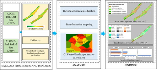
Potentiality of Synthetic Aperture Radar (SAR) based Radar Forest Degradation Index (RFDI) combined with field observations for monitoring spatio-temporal dynamics of intertidal mudflat vegetation was assessed in this study. Five vegetation zones were delineated in the Junput mudflat of eastern India with very high classification accuracy (Kappa coefficient ≥ 0.79). Fragmentation and coalescence patterns of different vegetation zones under two plantation initiatives were also analysed by different spatial metrics. Results reveal gradual degradation of tree dominated vegetation zones and growth of shrub dominated and herbaceous ones from 2007 to 2019. Plantation of exotic species like Eucalyptus globulus and Casuarina equisetifolia along the shoreline had been found to be less effective against storms and sea surges. Conversely, native mangrove plantations and associated herbs had demonstrated remarkable growth in the intertidal areas. Based on the findings, the study pointed out that a zone-wise cum site-specific plantation strategy is needed towards developing effective bio-shields.
Graphical Abstract
Acknowledgements
We are extremely grateful to the local villagers cum wetland users for providing valuable information during field investigations. We acknowledge the financial assistance provided by the Science and Engineering Research Board, Department of Science and Technology (DST-SERB), Government of India (SERB Sanction No. ECR/2017/003380, dated 26 November 2018) and RUSA 2.0, JU (Reference No. R-11/369/2019 dated 1 April 2019) to the Corresponding author as Major Research Projects.
Disclosure statement
The authors declare that they have no known competing interests that could have appeared to influence the work reported in this article.
Data availability statement
The data that support the findings of this study are available from the corresponding author, upon reasonable request.
Table 6. Comparison among class-level metrics of two plantation phases (2007 and 2019) of the five vegetation zones of the study site.