
 ?Mathematical formulae have been encoded as MathML and are displayed in this HTML version using MathJax in order to improve their display. Uncheck the box to turn MathJax off. This feature requires Javascript. Click on a formula to zoom.
abstract
The importance of ecological protection cannot be overlooked. Starting from the source area of the Yellow River, this study adopts a new "service-sensitive-security" assessment framework to assess the importance of ecological protection. The results showed that: (1) The areas with high ecological protection degree were distributed in the east, north and west, accounting for 73.41% of the source area. (2) Ecosystem services are mainly carbon sequestration and water conservation. (3) The main problem of ecological sensitivity is soil erosion. (4) The ecological safety zone is located in the middle of the study area, indicating that the ecological protection of the region is good, and it is necessary to continuously strengthen the protection measures to ensure the stability and sustainability of the ecosystem. The purpose of this study is to provide a reference for local and regional ecological protection and zoning improvement through the refinement of zoning through ecological protection.
projection
The ecological pattern of the source area is distributed along the east, north and west ends.
As a key ecological function area in China, the ecological protection of the source area of the Yellow River is extremely important due to the ecological sensitivity and vulnerability of the source area of the Yellow River.
A new ecological protection evaluation framework was constructed, and ecological security evaluation indicators were added on the original basis to make it more in line with the ecological background of the source area.
The new framework provides a theoretical basis for ecological planning and localized ecological protection measures in refined source areas.
1. Introduction
To evaluate the importance of ecological conservation, the ecological importance is ranked by a comprehensive index of the structural performance and functional importance of the ecosystem (Lin et al., Citation2018). At present, when assessing the importance of ecological conservation, foreign studies mainly use protected area systems (Lin and Grimm Citation2015; Théau et al. Citation2015), which is very different from domestic studies and is of little significance as a reference (Liu et al. Citation2015; Tao et al., Citation2022). In China, the importance of ecosystem services (hereinafter referred to as importance) and ecological sensitivity (hereinafter referred to as sensitivity) were taken as the main research indicators (Xiong et al., Citation2018; Yan et al., Citation2021; Chen et al., Citation2022). On the basis of the comprehensive analysis of the ecological environment of the source area, the evaluation index system of typical ecological service functions and main ecological problems in the source area was constructed, and the typical ecological service functions and main ecological problems in the area were pointed out, so as to make a better evaluation (Huang et al. Citation2020; Zhang and Ye, Citation2023).
Assessing the importance of ecological conservation can be seen as assessing the importance and assessing the sensitivity (Rong et al. Citation2019; Li et al., Citation2022). At the same time, the methods of assessing importance include the parametric method (Costanza et al. Citation1997), the model method (Zhao et al. Citation2017), and the quantitative index evaluation method (Lv et al. Citation2013). According to the actual situation in different places, different sensitive factors were selected for ecological sensitivity analysis (Shi et al. Citation2018; Chi et al., Citation2019; Luo et al., Citation2023).
At present, evaluation research in China is mainly conducted from two aspects. On the one hand, a small number of scholars have discussed the importance of ecological conservation and its spatial distribution in designated areas (Xu et al. Citation2008; Li et al., Citation2011; Huang et al. Citation2023) and explored the correlation between different ecological sensitivity indicators and ecosystem services based on the above analysis (Niu et al. Citation2022); On the other hand, a large number of scholars have taken the evaluation of the importance of ecological conservation as the basic information for related research on the construction of ecological security patterns (Gao et al. Citation2023; Xue et al., Citation2023), delineation of ecological protection redlines (Liu et al., Citation2023), delineation of ecological function zones (Sun et al., Citation2021), delineation of ecological spaces (Hong et al., Citation2023), etc. The research in this direction mainly focuses on the scientific planning of ecological space, the effective protection of important ecological functions, and the enhancement of the overall ecological carrying capacity of the region, so as to maintain the integrity of the ecosystem.
However, at present, most of the relevant studies focus on some specific issues, and there is no overall evaluation and functional zoning research, and the role of supporting regional and territorial spatial planning is less. Therefore, according to the high altitude characteristics of the source area, it is an important prerequisite to accurately evaluate the ecological environment and main problems in the target area. In view of this situation, the source area was taken as the research area, combined with the evaluation methods and methodological innovation practices proposed in the "double evaluation" guide, and the functional sensitivity was taken as the starting point, and the ecological security perspective was added to determine the key areas of ecological protection. The construction of ecological civilization is an inevitable requirement for the development of human civilization and social progress, and it is also an urgent need to improve the ecological environment.
The importance evaluation was evaluated from four aspects, and various factors generated by the evaluation method were analyzed, which could be used to evaluate the importance level of ecosystem service function in the source area. In this study, the ecological sensitivity of two typical ecological problems was evaluated, and the ecological sensitivity of these two problems was graded. In addition, this paper combines ecological security assessment with comprehensive analysis to obtain the importance level of ecological protection in the source area and analyze its spatial distribution. Finally, the study of "function-sensitivity-safety" zoning in the source area was carried out to provide support for the future spatial planning and ecological restoration of the source area, and to ensure the quality of regional ecological civilization construction.
2. Materials and methods
2.1. Source Region Overview
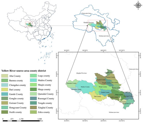
The source area is located in the northeastern part of the Tibetan Plateau (32°06′∼36°12′N, 95°48′∼103°24′E), accounting for 15% of the entire basin (Chen et al. Citation2023). The source area is ecologically fragile and has weak disaster prevention and mitigation capabilities (Han et al. Citation2021), originating from the Bayanhar Mountains, and the topography is high in the west and low in the east (Brierley et al. Citation2016).
Figure 1, the study area covers 2015 prefectures and 2018 counties in Qinghai, Sichuan, and Gansu provinces (Wu et al. Citation2015). It is an important water production and water retention area in the whole basin (Ye et al. Citation2018), which has an extremely important impact on the water content of the basin. The source area is about <> million kilometers2, with an average annual runoff of about 19.<> billion meters3(from 1956 to 2017). With the continuous development of social economy in the source area, human behavior has led to the gradual shrinkage of lakes and wetlands in the source area, the gradual reduction of local vegetation coverage, and the gradual degradation of glacial permafrost in the source area, which in turn leads to the gradual decline of water resource protection capacity in the source area. Due to the difficult living conditions, the economic development of the study area is relatively lagging behind. Therefore, the ecology is extremely fragile, and the ability of alpine wetland ecosystems to resist disturbance is weak.
Figure 1. Map of the study area.
2.2. Data sources
The data involved in this study mainly includes DEM (https://www.gscloud.cn/), which reflects the topographic features and generates slope and slope orientation data based on DEM. Meteorological data from the National Earth System Science Data Centre (http://gre.geodata.cn/). NPP data and NDVI data are from the Cloud Platform for Resource and Environmental Data of the Chinese Academy of Sciences (https://www.resdc.cn). Soil data from HWSD and socio-economic data from the statistical yearbooks of the Yellow River source area and cities and counties. All data were resampled at 30 m spatial resolution for the study.
2.3. Research methodology
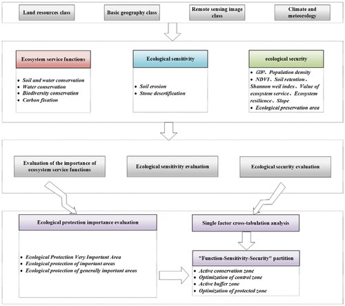
To ensure ecologically sustainable development that can generate social and economic benefits, it is necessary to evaluate the impact of human behaviors on ecosystems and reduce the negative impact of all types of development activities on ecosystems and their evolutionary processes (Ruiz et al. Citation2012). As ecological services going to higher levels, the risk of causing damage to ecosystem functions increases in the region. Therefore, the ecological resistance thereupon increases (Zhao et al. Citation2020). The stronger the ecological sensitivity, the poorer the self-restoration and self-renewal capacity of regional ecosystems to withstand disturbances, and the higher the risk of ecosystem degradation. Therefore, it becomes more difficult to work on ecological conservation and ecological restoration (Xu et al. Citation2023). Therefore, importance and sensitivity are usually used as key indicators to evaluate the importance of regional ecological protection. On this basis, ecological security is incorporated as a new evaluation index, and an evaluation index system is constructed for the typical ecological service functions and main ecological problems (Xu et al. Citation2021; Ma et al. Citation2023; Zhang et al. Citation2023). The ecological protection importance level is assessed based on the principle of the short-board effect of the carrying capacity of resources and the environment. On the basis of the evaluation results of individual indicators, the ecosystem service function (Max), ecological sensitivity (Max), and ecological security level (Max) are considered comprehensively, and the highest value in the results is superimposed and selected to determine the ecological protection importance level. This is a study on ecological conservation importance evaluation and its zoning research. The specific process is shown in .
Figure 2. Research process diagram.
2.3.1. Soil and water conservation
Evaluating soil and water conservation using the NPP method (Wang et al. Citation2022), As shown below:
(1)
(1)
Where represents soil and water conservation, represents the average annual net primary productivity of vegetation, represents the slope factor, and represents the soil erodibility factor.
2.3.2. Water conservation
Use of the NPP quantitative indicator method to assess water conservation (Wu and Meng Citation2022), As shown below:
(2)
(2)
Where represents Water Conservation, represents the mean annual Net Primary Productivity of vegetation, denotes the soil infiltration factor, represents the factor of average annual precipitation, and represents the slope factor.
2.3.3.Ity conservation
Assessment of Ecosystem Service Capacity Index for Biodiversity Maintenance (Peng et al. Citation2018), formula is as follows:
(3)
(3)
Where represents Biodiversity conservation, represents the mean annual Net Primary Productivity of vegetation, represents the factor of average annual precipitation, denotes the factor of average annual temperature, and represents the factor of elevation.
2.3.4. Carbon fixation
Evaluating carbon fixation using NPP (Wang et al. Citation2022), formula is as follows:
(4)
(4)
Where represents the carbon storage capacity index, represents the average net primary productivity of vegetation over multiple years, and represents the standard deviation of net primary productivity of vegetation within one year.
2.3.5. Soil erosion
The formula for calculating the soil erosion index (Jin et al. Citation2021), taking into account the characteristics of the source area background, is as follows:
(5)
(5)
Where stands for soil erosion index, and its evaluation factors include rainfall erosivity soil erodibility slope length and slope steepness index and surface vegetation Cover
2.3.6. Stone desertification
Studying the sensitivity to rocky desertification can be utilized to identify regions that are prone to the impacts of rocky desertification, thereby reflecting the local ecological sensitivity zones (Wang et al. Citation2022), is as follows:
(6)
(6)
where refers to the sensitivity index of stone desertification, refers to the percentage of exposed carbonate rock area, refers to the terrain slope, and represents vegetation coverage.
2.3.7. Ecological safety
Ecological security is measured by the superposition of factors that affect ecological security (Tang et al. Citation2023), as follows:
(7)
(7)
where represents ecological security, represents the weight of each indicator, and represents the normalized value of each indicator.
3. Results and analysis
3.1. Importance analysis
The results of the single-factor evaluation of the importance are shown in and . In the section, the ecosystem service function is dominated by water conservation and carbon fixation. In this case, the utmost important area of functional importance of carbon fixation accounts for 32.66% of the area of the source area. The areas with high importance of ecosystem function in general, which include Hongyuan County, Aba County, Ruoergai County, Luqu County and exclude a small part of Ruoergai County with low importance can basically conclude that the areas with high importance are distributed along the eastern part of the source area.
Figure 3. Single factor of ecosystem service functions in the source area: (a) soil and water conservation; (b) water conservation; (c) biodiversity conservation; (d) carbon fixation.
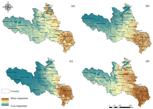
Table 1. Proportion of single factors of the importance in source area/%.
The areas with higher importance value of soil and water conservation function are distributed in Gonghe County, Guinan County, Ruoergai County, Hongyuan County, Aba County, and some areas in Maqu County, and the areas with lower importance are distributed in the western counties. In terms of the importance value of water resource conservation, the areas with high importance in the east are scattered among slightly weaker areas. The results of the importance of biodiversity maintenance function can indicate that the importance of western areas is generally low, and can conclude that the importance value of eastern areas is higher and that of western areas is lower. The areas with high importance value of biodiversity maintenance function, water resource conservation function and carbon fixation function are more concentrated, while the areas with high importance for soil and water conservation function are more scattered.
The evaluation of the importance is shown in and . Ecosystem service function is significantly important in the source area. The evaluation results show that the importance of ecological services in all counties in the eastern part of the source area is high, where the utmost important area generally covers more than 45%. By comparison, it can be seen that the utmost important areas in Maqu County, Aba County, Banma County, Ruoergai County, Hongyuan County, and Zeku County cover more than 75%, which is significantly higher than other counties. This indicates that their service functions as ecological barriers are extremely important in maintaining regional ecological functions and should be given priority attention.
Figure 4. Ecosystem service functions in source area.
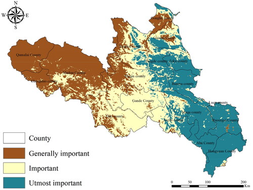
Table 2. Statistics on the importance of ecosystem service functions.
Luqu County is not included because of its small proportion in the source area. The area of utmost important areas in the counties of Dari, Maduo, Qumalai, and Chengduo is 0 km2. However, the important areas in Dari and Maduo counties take up 8482.69km2and 3451.27 km2, respectively. The results show that these two counties should be attached more importance for their significant roles in maintaining regional ecological functions although there is no utmost area in the counties. The priority of ecological service function for Qumalai and Chengduo counties can be lower than that of highly important areas such as Maduo County. Overall, the importance in the source area shows an even distribution at three levels.
3.2. Ecological sensitivity evaluation
As shown in and , from the single-factor evaluation of ecological sensitivity, the sensitivity of stony desertification is not high in general. The most of the source area is located in the area with weak sensitivity, where the general sensitivity accounts for 80.41% of the total area, and utmost sensitive area only accounts for 10.20%. From the perspective of spatial distribution, it shows a trend of decreasing from the northeast to the southwest. Soil erosion plays a dominant role in ecological sensitivity, and the extremely sensitive area accounts for 30.70% of the source area. The areas with strong sensitivity are distributed in Qumalai County, Mado County, Chengduo County, Ruoergai County, and other areas, where the soil is vulnerable to erosion, and the industrial structure of the source area is simple with the dominance of animal husbandry. In recent years, the rising global temperature has led to the rapid melt of permafrost and the increased water volume in the watershed, which has caused a series of soil erosion problems. In addition, anthropogenic activities can also lead to the emergence of this phenomenon.
Figure 5. Ecologically sensitive monofactor in the source area: (a) soil erosion; (b): stone desertification.
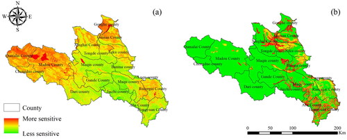
Table 3. Proportion of single factors of the sensitivity in source area/%.
As shown in and , comparing the ecological sensitivity distribution status of each county, the eighteen counties can be divided into three categories. The first category includes five counties such as Maduo County, Qumalai County, and Chengduo County, the area of ecologically utmost sensitive areas within the county area is more than 50%, and the risk of soil erosion and rock desertification in the region is high. Due to the location of Maduo County in the west of the source area and in the core area of the three river source (Yangtze, Yellow, and Lancang rivers) Nature Reserve, it is more important to focus on other types of ecological problems that can be represented by water environment quality, which should also be a key area of ecological restoration. The second category includes nine counties such as Ruoergai County, Hongyuan County, Aba County, and Maqu County. The area of ecologically utmost sensitive areas exceeds 20%, and some areas show a particular concentration of utmost sensitive areas. The third category includes the rest of the counties with a relatively low proportion of utmost sensitive areas and the average proportion of general sensitive areas. However, in general, the risk of ecosystem degradation is relatively low. Jiuzhi County has a small percentage of both utmost sensitive areas and sensitive areas, the comparison shows the low ecological sensitivity in this county.
Figure 6. Ecologically sensitive results in the source area.
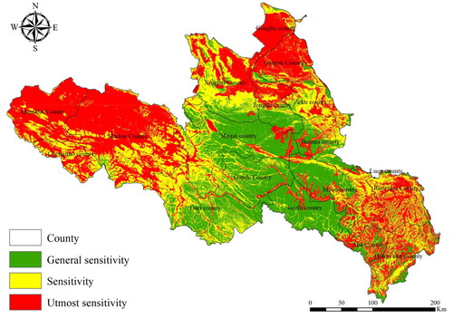
Table 4. Ecological sensitivity classification statistics.
3.3. Ecological safety evaluation
This study applies the PSR model for ecological security evaluation in the source area. In terms of the selection of the ecological security evaluation indexes in the source area, population density and gross national product are selected as pressure indicators because pressure refers to the impact of human behaviors on ecological security. The NDVI, Shannon Weil index, ecosystem service value, ecosystem elasticity, slope, and soil conservation amount are selected as state indicators because state refers to the condition of the ecological environment from all perspectives. The ecological protection zones should be taken as response indicators because the response refers to the initiatives made to maintain ecological security and promote coordinated ecological and economic development. In this paper, the entropy value method is used to assign different weights, as shown in .
Table 5. Ecological security evaluation indicators/%.
Each index data was normalized individually to ensure the values of data are between [0,1], and the normalized indexes were superposed and analyzed to calculate ecological safety. Then the ecological safety evaluation results are divided into three levels: safe, generally safe, and unsafe. The higher the ecological safety level in the evaluation results, the safer a certain area in the Source Area. The spatial distribution of ecological safety in the source area in 2005, 2010, 2015, and 2020 is shown in and . In recent years, most of the source area is in the general security level, compared to the higher security level of the area, which accounts for less. Therefore, it is still necessary to strengthen ecological security protection in the source area.
Figure 7. Changes in ecological security in the source areas from 2005 to 2020.
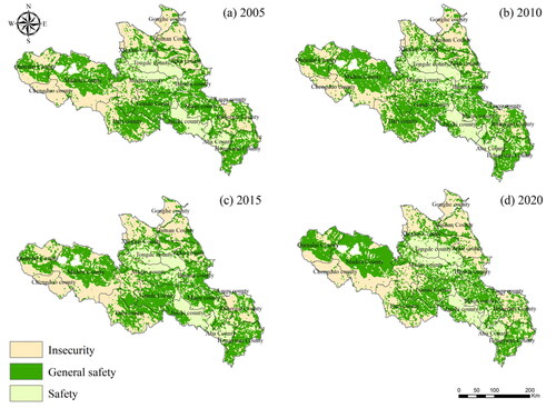
Table 6. Ecological security as a percentage of the area of the source area statistics/%.
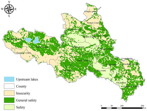
The above results were overlaid and analyzed to obtain the ecological security of the source area, as shown in . In general, the safety level of the western counties in the source area is low, and some areas such as Chengduo County and Maduo County are ecologically insecure. Maqin County, Banma County, Maduo County, Jiuzhi County, etc., most of these counties have a high level of ecological security. The main reason for this phenomenon is that these areas are all in the core ecological reserve of the source area, the population density is relatively small, the biodiversity is good, and the impact of human activities is less. It is worth mentioning that there is more forest land in Ruoergai area, the natural ecological environment is good, and the overall ecological security level is basically at the general safety level.
Figure 8. Ecological security distribution in the source area.
3.4. Ecological Conservation Importance Assessment and "Functional-Sensitive-Safe" Zoning
3.4.1. Assessment of the importance of ecological conservation
Most of the source areas are located in the most important areas and important areas of ecological protection, and it is necessary to strictly implement ecological protection in the development process to prevent ecological degradation. As shown in and .
Figure 9. The importance of ecological protection in the source area. type
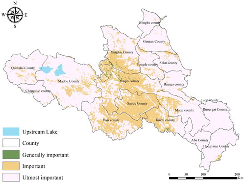
Table 7. Evaluation of the importance of ecological protection in the source area. type
Overall, the most important area for ecological protection covers an area of 92.300 million kilometers2, accounting for 73.41% of the area. In this case, 12 counties, including Ruoergai County, Aba County, Maqu County, Banma County, Hongyuan County and Maduo County, accounted for more than 80% of the county's area. 32,900 kilometers of important areas for ecological protection2, accounting for 26.19% of the source area. A small number of areas of overall importance with ecological protection are distributed in the vicinity of Maqin County, Xinghai County and Jiuzhi County, covering an area of about 511.03 km2, accounting for about 0.41%. In general, the importance value of ecological protection in the source area is high, accounting for more than 80% of the most important areas, and the proportion of general important areas is relatively low, less than 5%. In addition, land use types with weak ecological functions are scattered in the most important areas of ecological protection, which may have certain adverse effects on the ecosystem.
3.4.2. One-way cross-tabulation analysis
There may be some spatial correlation in the single-factor ecological assessment, Figure 10.
Figure 10. Univariate crossover analysis.
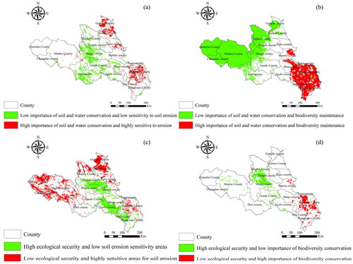
An overlay analysis was performed on Figure (a). The analysis showed that the areas with high importance of soil and water conservation (the most important) and high sensitivity to soil erosion (the most sensitive) were concentrated in the vicinity of Ruoergai County, Gonghe County and Guinan County. The areas with low importance of soil and water conservation (general importance) and low sensitivity to soil erosion (general sensitivity) were concentrated near Dali County and Maqin County, indicating that there was a strong correlation between soil erosion sensitivity and soil erosion conservation in spatial distribution.
An overlay analysis was performed on Figure (b). From the perspective of spatial distribution, the areas with high importance of biodiversity conservation (the most important) and the high importance of water resources dialogue (the most important) were concentrated in the vicinity of Aba County, Ruoergai County and Maqu County. Therefore, the management and restoration of the main wetlands in the area should be strengthened. On the basis of improving the quality of existing forest resources, the hillside should be closed, which is conducive to afforestation, restoration of natural vegetation, and expansion of the effective coverage rate of forest vegetation. The regions with low values of importance for biodiversity conservation function (general importance) and weak water resources dialogue function (general importance) are distributed in the western region. This is due to the low vegetation cover in the area, which affects the functioning of the water dialogue and the maintenance of biodiversity.
The superposed results of ecological safety and water and soil erosion sensitivity evaluation show that the areas with high ecological safety (safe) and low erosion sensitivity (general sensitivity) are concentrated in the vicinity of Maqin County, Tongde County, Jiuzhi County, and Aba County, which accords with the above conclusion. This is because this area belongs to the core protection zone of the source area. The areas with low ecological safety (general safety and unsafety) and high sensitivity to soil erosion (utmost sensitivity) are mainly located in the counties near the source and the areas near Gonghe County and Guinan County. Therefore, it is necessary to strengthen the protection of the ecological environment in these areas.
The ecological safety and biodiversity evaluation results are superposed and analyzed. The areas with low ecological safety (general safety and unsafety) and high importance value of biodiversity maintenance (utmost importance) are mainly located near Ruoergai County. Therefore, ecological protection and restoration should be implemented for important water resource conservation and ecological function areas such as the Ruoergai Grassland in the upper reaches of the Yellow River. The areas with high ecological safety (safe) and low importance value of biodiversity maintenance (general importance) are concentrated near Xinghai County and Maqin County, where biodiversity maintenance in both counties needs to be strengthened.
3.4.3. Collaborative ‘function-sensitivity-security’ partition identification
Ecological function zoning starts with determining the natural background of the Source Area and the current ecological problems, along with the combination of ‘Function-Sensitivity-Security’. This is done by standardizing the z-score for the three evaluations. This is a process of dividing the difference between the score and the mean by the standard deviation, which shows the relative position of a particular value in the data set and truly reflects the relative standard deviation of a value to the mean. The calculation formula is shown below (Xu et al. Citation2022).
(8)
(8)
In the formula, is the result obtained after standardization, is the observed value of the data, is the mean value of the overall data, and is the standard deviation of the overall data.
The z-score standardization was used to partition the source area. The more intuitive way () of guiding the partition can be seen from the importance of ecological service function on the axis, the evaluation of ecological security on the axis and the three-dimensional scatter diagram of ecological security evaluation on the axis.
Figure 11. Source region ‘function-sensitivities - safety’ three-dimensional scatter plot.
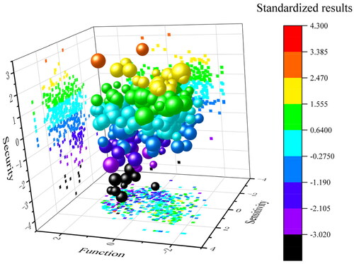
In this study, the spatial analysis method is applied for zoning according to the normalization of each index. Based on the Natural Breaks method, the zoning result can be seen as the following four zones ().
Table 8. Source zone zoning standard.
The active conservation zone is an area with a standardized posterior value less than 0.3097. Since the overall ecological environment of the source area is relatively fragile, this zone takes up a small area and is distributed in the central part of the Source Area near Xinghai County, Maqin County, Gande County, and Dari County. This zone contains several counties, including the planning area of the Sanjiangyuan National Park. In the future, it will still be necessary to strengthen ecological protection and restoration in this area.
The optimization of the control zone is an area with standardized posterior values between 0.3097 and 0.8636, which are distributed within most of the Source Area, accounting for 31.09% of the source area (, ). It is an area dominated by grassland in the south, central, and north. This is a large agricultural and animal husbandry zone in the Source Area with a large population and beautiful natural scenery. Based on ecological protection, it is potential to develop characteristic industries such as green agriculture, animal husbandry, and ecological tourism in this zone. Meanwhile, green tourism resources should be shared, soil erosion, desertification control, and vegetation recovery should be improved. The optimization of the control zone embraces the ecological protection zone in good ecological condition. To protect the ecological protection zone in a better way, the residents should be clearly regulated on the scope of activities and the way of living and production, apart from the necessary ecological treatment and restoration projects as well as infrastructure.
Figure 12. The ‘functional-sensitive-security’ partition of the source area.
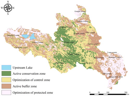
Table 9. ‘Functional-sensitive-secure’ zoning results as a percentage of the area of the source area/%.
The active buffer zone is the area with a standardized posterior value between 0.8636 and 1.4175, mainly concentrated in the eastern, northern, and western regions of the Source Area, accounting for 30.39% of the source area. Based on the intact ecosystem structure and ecological function, the area is suitable for the construction of ecological protection projects, and for the construction of ecological agriculture and animal husbandry on a certain scale to enhance the ecosystem service function in this area.
The optimization of protected zone is an area with standardized values between 1.4175 and 3.1780, that is distributed in the eastern, northern, and western parts of the source area. The eastern part is mainly distributed in an area dominated by wetland type. Combined with the cross-analysis of single-factor evaluation results, it can be concluded that the eastern part should be the area of water resource conservation and biodiversity maintenance function, while the western part should be the area of ecological protection and soil erosion protection. Therefore, the Source Area and Sanjiangyuan National Park should be regarded as important bases for improving ecological security maintenance, the ecosystem function of resource conservation, and biodiversity protection. Ecological conservation, wetland ecosystem protection and natural and artificial vegetation restoration should be strengthened in this area, and the construction of ecological source areas should be given more attention to expand the ecological source areas.
4. Discussion
4.1. Constructing new research methods for necessary ecological conservation
Ecosystems are the basis of human life and progress, constantly providing ecological goods and services to humans, and are indispensable natural resources and wealth (Mufungizi et al. Citation2023). However, natural ecosystems are now facing unprecedented pressure and various degrees of degradation (Xu et al. Citation2007; Newbold et al. Citation2015). Ecological conservation is an important way to improve the ecological environment, enhance ecosystem services and maintain ecological security (José et al. Citation2009). Usually, the identification and delineation of protection and restoration areas follow the basic principles of whole area, whole process, and whole element, with the construction of a zoning indicator system adapted to the geographical characteristics as the main research method (Zhai et al. Citation2019; Wang et al. Citation2021). Among them, ecosystem service function is a common ecological function indicator (Li et al. Citation2021). In addition, some studies have built regional ecological sensitivity evaluation on this basis, combined with socio-economic development factors, to assess the priority of regional ecological protection and restoration by considering ecosystem service function and ecological sensitivity. This method has been widely used. However, research methods in this area are still limited, and to fill the gap, this study integrates ecosystem service function and ecological sensitivity, and proposes a new method for identifying ecologically critical areas in the context of ecological security. The rationale for including ecological security as part of the assessment framework is that it has the potential to make ecological conservation evaluations more precise and to ensure sustainable regional development.
4.2. Source area ecological management zoning recommendations
Space resources are not unlimited, and we should manage or regulate their use. The complexity of human activities in recent years (Huang et al. Citation2023), after clarifying the scope of ecological space, it is necessary to put forward appropriate control measures or recommendations according to the development direction and objectives of each region. Ecological functional zones are a key component in maintaining the sustainability of ecosystems (Li et al. Citation2023).
In recent years, different studies will have different perspectives on the delineation of priority conservation areas, and therefore different methods may be chosen to identify priority conservation areas. There are studies that designate higher ecosystem service areas as ecological priority conservation areas (Shao and Yang Citation2023), the phenomenon of three-level classification of ecological zones exists (Huang et al. Citation2023), and there is also model-based ecological zoning (Chen et al. Citation2022). This study adds innovation to this field by performing ecological zoning based on ecological protection as well as superimposed results between two single elements, and the zoning results are combined with actual national as well as local policies to provide theoretical support for the development of regional management. Therefore, in the future development process of the Yellow River source area, it is especially important to carry out ecological protection work according to local conditions by combining theory with practice.
4.3. Limitations of the study
The evaluation method of this study needs to be improved. On the one hand, the theoretical and scientific evaluation and grading of the three evaluation indexes need to be improved. On the other hand, the accuracy of the data should be improved because a wide variety of data is involved in the evaluation process, with different types and scales of data, and some data has been missed. Although a uniform spatial resolution has been obtained through methods such as resampling, its impact on the accuracy of the spatial details in the evaluation results has not been thoroughly studied. On the basis of following the laws of system operation, this study should apply local practice for scientific evaluation and provide a reference for similar regions in terms of the importance evaluations of ecological conservation. When evaluating the importance of ecological protection, regional differentiation characteristics should be clarified and combined with local natural geographical characteristics. The basic data at appropriate scales can be selected with the application of scientific evaluation methods to ensure the accuracy and reliability of the evaluation results. Based on the evaluation and grading of ecological protection importance, and the combination with local planning policies (Xiao et al. Citation2022), suggestions could be proposed to the delimitation of ecological protection space and to provide support for territorial spatial planning.
5. Conclusion
By evaluating the importance of ecological protection, a new method of identifying ecologically critical areas based on the use of ecological indicators is proposed. A new assessment framework based on function-sensitivity-safety is constructed following the current mainstream dual evaluation research paradigm. Considering the current ecological background and local policies of the ecological source area comprehensively, the study on the identification of ecologically critical areas for ecological protection is carried out. The study can provide support for the ecological management and sustainable development of the Yellow River source area. The results show that the overall ecological environment of the source area is relatively fragile, and the ecological protection of the east, north, and west of the source area is extremely important. The ecosystem service function is generally stronger, showing a decreasing trend from the southeast to the west. The risk of soil erosion and rocky desertification in some of the counties in the source area is higher, and Maduo County should be the key area for ecological restoration. The central part of the source area has a higher level of ecological safety, with better biodiversity, lower population density, and less anthropogenic impact. It is recommended that the counties should also implement ecological protection priorities. Therefore, this paper can refine the spatial ecological restoration zoning of the source area and provide suggestions for small-area ecological restoration management. On this basis, corresponding protection measures are proposed according to different regions to provide a basis for regional ecological management.
In summary, this study proposes a new method for identifying ecologically critical areas by reconstructing the ecological protection importance evaluation index system, so that the method is more compatible with the background ecological conditions of the source area. In terms of methodology, this study introduces the ‘function-sensitivity-security’ framework, which enriches the existing research framework.
Authors’ contributions
Haoxiang Zhang and Qian Song were involved in the conception and design of the study. Data collection and analyses were carried out by Haoxiang Zhang, the first draft of the manuscript was written by Haoxiang Zhang, resources were handled by Jianyun Zhao and Qian Song, the survey was carried out by Peijia Liu, Zhibo Lu, and Shiru Wang, and all authors read and approved the manuscript.
Acknowledgments
We thank the editors and reviewers of Geocarto International for their critical guidance. All authors have been informed of and agreed to the inclusion of the manuscript.
Disclosure statement
The authors declare that there are no competing interests relevant to this article to declare.
Data availability statement
The first author may provide the required data upon reasonable request ([email protected]).
Additional information
Funding
References
- Brierley GJ, Li XL, Cullum C, Gao J. 2016. Introduction: landscape and ecosystem diversity in the yellow river source zone, 1–34. doi: 10.1007/978-3-319-30475-5_1.
- Chen J, Wang SS, Zou YT. 2022. Construction of an ecological security pattern based on ecosy-stem sensitivity and the importance of ecological services: a case study of the Guanzhong Plain urban agglomeration, China. Ecol Indic. 136:108688. doi: 10.1016/j.ecolind.2022.108688.
- Chen MJ, Tian F, Cao XY, Zhang WY, Plessen B, Mischke S. 2023. Hydrological variations in the Yellow River Source area (NE Tibetan Plateau) during the last 7.4 ka inferred from stable isotopes of ostracod valves. CATENA. 232:107328. doi: 10.1016/j.catena.2023.107328.
- Chen Z, Zhang H, Xu M, Liu Y, Fang J, Yu X, Zhang S. 2022. A study on the ecological zoning of the Nantong coastal zone based on the Marxan model. Ocean Coastal Manag. 229:106328. doi: 10.1016/j.ocecoaman.2022.106328.
- Chi Y, Zhang ZW, Gao JH, Xie ZL, Zhao MW, Wang EK. 2019. Evaluating landscape ecological sensitivity of an estuarine island based on landscape pattern across temporal and spatial scales. Ecol Indic. 101:221–237. doi: 10.1016/j.ecolind.2019.01.012.
- Costanza R, d‘Arge R, de Groot R, Farber S, Grasso M, Hannon B, Limburg K, Naeem S, O'Neill RV, Paruelo J, et al. 1997. The value of the world’s ecosystem services and natural capital. Nature. 387(6630):253–260. doi: 10.1038/387253a0.
- Gao MH, Li C, Zhao J, Zhao H. 2023. Identification of ecological security pattern based on ecosystem service supply and demand in the Yangtze River Delta, China. Geocarto Int. 38(1):1. doi: 10.1080/10106049.2023.2252787.
- Han LY, Zhang Q, Ma PL, et al. 2021. Characteristics of drought disasters risk in the Yellow R-iver Basin under the climate warming. J Desert Res. 41:225–234. doi: 10.7522/j.issn.1000-694X.2021.00082.
- Hong WY, Liao CC, Guo RZ, An Q, Li XM, Ma T. 2023. Predicting the minimum scale of urban ecological space based on socio-ecological systems analysis. Sci Total Environ. 863:160912. doi: 10.1016/j.scitotenv.2022.160912.
- Huang F, Zuo L, Gao J, Jiang Y, Du F, Zhang Y. 2023. Exploring the driving factors of trade-offs and synergies among ecological functional zones based on ecosystem service bundles. Ecol Indic. 146:109827. doi: 10.1016/j.ecolind.2022.109827.
- Huang H, Lu W, Zuo G, Liu Z, Liu C, Wang X, Li X, Ma Y, Yu J. 2023. Ecological distribution patterns in Chinese seas and adjacent waters: marine ecological zones. Sci Total Environ. 905:167259. doi: 10.1016/j.scitotenv.2023.167259.
- Huang J, Qu JF, Chen Y. 2023. Research on evaluation of the importance of land spatial ecological protection of resource-exhausted cities: a Case of Jiawang District, Xuzhou City. Terr Nat Resou Study. 2023(3):51–54. doi: 10.16202/j.cnki.tnrs.2023.03.011.
- Huang XY, Zhao XM, Guo X, Jiang YF, Lai XH. 2020. The natural ecological spatial management zoning based on ecosystem service function and ecological sensitivity. Acta Ecologica Sinica. 40:1065–1076. doi: 10.5846/stxb201811152474.
- Jin XX, Wei LY, Wang Y, Lu YQ. 2021. Construction of ecological security pattern based on the importance of ecosystem service functions and ecological sensitivity assessment: a case study in Fengxian County of Jiangsu Province, China. Environ Dev Sustain. 23(1):563–590. doi: 10.1007/s10668-020-00596-2.
- José M, Rey Benayas JM, Newton AC, Diaz A, Bullock JM. 2009. Enhancement of biodiversity and ecosystem services by ecological restoration: a meta-analysis. Science. 325(5944):1121–1124. doi: 10.1126/science.1172460.
- Li H, Yang SH, Yao WJ, Wang SQ, Yi N, Liu DB. 2011. Evaluation of ecological conservation importance via GIS approach in the middle reaches of Nujiang watershed. Chin J Eco-Agricult. 19(4):947–953. doi: 10.3724/SP.J.1011.2011.00947.
- Li H-R, Ma S, Zhang M, Yin Y-K, Wang L-J, Jiang J. 2023. Determinants of ecological functional zones in the Qinghai-Tibet Plateau ecological shelter at different scales in 2000 and 2015: from the perspective of ecosystem service bundles. Ecol Indic. 154:110743. doi: 10.1016/j.ecolind.2023.110743.
- Li X, Yu X, Wu K, Feng Z, Liu Y, Li X. 2021. Land-use zoning management to protecting the Regional Key Ecosystem Services: a case study in the city belt along the Chaobai River, China. Sci Total Environ. 762:143167. doi: 10.1016/j.scitotenv.2020.143167.
- Li ZG, Zhong JL, Yang J, Zhang D, He S. 2022. Assessment framework and empirical analysis of the ecological protection importance for key town agglomerations in China. J Cleaner Prod. 372:133682. doi: 10.1016/j.jclepro.2022.133682.
- Lin T, Grimm NB. 2015. Comparative study of urban ecology development in the U.S. and China: opportunity and Challenge. Urban Ecosyst. 18(2):599–611. doi: 10.1007/s11252-014-0413-9.
- Lin ZY, Xiao Y, Shi XW, Rao EM, Zhang P, Wang LY. 2018. Assessment of the ecological im-portance patterns in southwest China. Acta Ecologica Sinica. 38(24):8667–8675. doi: 10.5846/stxb201805241139.
- Liu D, Lin NF, Zou CX, You GY. 2015. Development of foreign ecological protected areas and linkages to ecological protection redline delineation and management in China. Biodiversity Science. 23(6):708–715. doi: 10.17520/biods.2015131.
- Liu YG, Wang L, Lu YF, Zou Q, Yang L, He Y, Gao WJ, Li Q. 2023. Identification and optimization methods for delineating ecological red lines in Sichuan Province of southwest China. Ecol Indic. 146:109786. doi: 10.1016/j.ecolind.2022.109786.
- Luo QY, Bao Y, Wang ZT, Chen XT, Wei WF, Fang ZY. 2023. Vulnerability assessment of urban remnant mountain ecosystems based on ecological sensitivity and ecosystem services. Ecol Indic. 151:110314. doi: 10.1016/j.ecolind.2023.110314.
- Lv YH, Zhang LW, Wang JL. 2013. Assessment of ecosystem and its services conservation: ind-icators and methods. Chin J Appl Ecol. 24:1237–1243. doi: http://ir.rcees.ac.cn/handle/311016/8755.
- Ma W, Zhang WX, Wang HR, Jin F, Du B, Wu FQ. 2023. Land use change and ecological se-curity in Aksu. J Beijing Norm Univ (Nat Sci). 59(1):113–124. doi: 10.12202/j.0476-0301.2021317.
- Mufungizi AA, Musakwa W, Chanza N. 2023. Shifting ecosystems, past, current, and emerging trends: a bibliometric analysis and systematic review of literature. Ecol Indic. 156:111175. doi: 10.1016/j.ecolind.2023.111175.
- Newbold T, Hudson LN, Hill SLL, Contu S, Lysenko I, Senior RA, Börger L, Bennett DJ, Choimes A, Collen B, et al. 2015. Global effects of land use on local terrestrial biodiversity. Nature. 520(7545):45–50. doi: 10.1038/nature14324.
- Niu XN, Ni H, Chen GG, Zhang DY, Zhang J, Zhang J, Wu JY. 2022. Evaluation of ecological conservation importance of Fujian Province. Acta Ecol Sinica. 42(3):1130–1241. doi: 10.5846/stxb202012153187.
- Peng CC, Cai YM, Bian ZX. 2018. Delineating an ecological red line in Yantai, Shandong Province. J Zhejiang A&F Univ. 35(5):818–828. doi: 10.11833/j.issn.2095-0756.2018.05.005.
- Rong YJ, Guo XY, Du SX, Li X, Ning T, Zhang MY. 2019. The spatial analysis of Ecologica-l carrying capacity of psr model based on ecosystem service function and ecological sensitivity. Bul Soil Water Conversat. 26(1):323–329. doi: 10.13869/j.cnki.rswc.2019.01.047.
- Ruiz MC, Romero E, Pérez MA, Fernández I. 2012. Development and application of a multi-criteria spatial decision support system for planning sustainable industrial areas in Northern Spain. Autom Constr. 22:320–333. doi: 10.1016/j.autcon.2011.09.009.
- Shao S, Yang Y. 2023. Identification of ecological improvement zones in different ecological functional zones in northwest Hubei, China. Ecol Indic. 155:111032. doi: 10.1016/j.ecolind.2023.111032.
- Shi YS, Li JQ, Xie MQ. 2018. Evaluation of the ecological sensitivity and security of tidal flats in Shanghai. Ecol Indic. 85:729–741. doi: 10.1016/j.ecolind.2017.11.033.
- Sun MY, Yang RJ, Li XH, Zhang L, Liu Q. 2021. Designing a path for the sustainable development of key ecological function zones: a case study of southwest China. Global Ecol Conserv. 31:e01840. doi: 10.1016/j.gecco.2021.e01840.
- Tang HJ, Hou K, Wu SQ, Liu JW, Ma LX, Li XX. 2023. Interpretation of the coupling mechanism of ecological security and urbanization based on a Computation-Verification-Coupling framework: quantitative analysis of sustainable development. Ecotoxicol Environ Saf. 263:115294. doi: 10.1016/j.ecoenv.2023.115294.
- Tao PF, Li P, Ding Y, Liu J, Yang GP, Xiao H. 2022. Construction of ecological security pattern based on ecological importance assessment and minimum cumulative resistance model in Chongqing city. Bul Surve Map. 38(1):15–20. doi: 10.13474/j.cnki.11-2246.2022.0003.
- Théau J, Bernier A, Fournier RA. 2015. An evaluation framework based on sustainability-related indicators for the comparison of conceptual approaches for ecological networks. Ecol Indic. 52:444–457. doi: 10.1016/j.ecolind.2014.12.029.
- Wang C, Liu Y, Yu C, Liu X. 2021. Research progress on the arrangement of territorial ecological restoration. Prog Geogr. 40(11):1925–1941. doi: 10.18306/dlkxjz.2021.11.011.
- Wang SY, Zhao MM, Diao YJ, Ma X, Fu L, Wang XQ, Liu T, Chen G, Guo P. 2022. Evaluation method study and application of ecological protection importance of Changdu city in the eastern Qinghai-Tibet Plateau. GeoChina. 2022:1–19.
- Wu XF, Li GX, Pan XP, Wang YF, Zhang S, Liu FG, Shen YJ. 2015. Response of vegetation coverage to temperature and precipitation in the yellow river source region. Resource Sci. 37(03):512–521. http://www.resci.cn/CN/Y2015/V37/I3/512.
- Wu YD, Meng JJ. 2022. Quantifying the spatial pattern for the importance of natural resource e-cosystem services in China. J Nat Resour. 37(1):17–33. doi: 10.31497/zrzyxb.20220102.
- Xiao Y, Xiao Q, Zhang JD. 2022. Balancing the international benefits and risks associated with implementation of ecological policy on the Qinghai-Tibet Plateau, China. Gondwana Res. 115:183–190. doi: 10.1016/j.gr.2022.10.006.
- Xiong SG, Qin CB, Yu L, Lu L. 2018. Methods to identify the boundary of ecological space based on ecosystem service functions and ecological sensitivity: a case study of Nanning City. Acta Ecol Sinica. 38(22):25–37.
- Xu C, Liu M, An S, Chen JM, Yan P. 2007. Assessing the impact of urbanization on regional net primary productivity in Jiangyin County, China. J Environ Manage. 85(3):597–606. doi: 10.1016/j.jenvman.2006.08.015.
- Xu HQ, Li CQ, Shi TT. 2022. Is the z-score standardized RSEI suitable for time-series ecological change detection? Comment on Zheng et al. (2022). Sci Total Environ. 853:158582. doi: 10.1016/j.scitotenv.2022.158582.
- Xu WH, Ouyang ZY, Wang XZ, Wang WJ, Dong RC, Bai Y. 2008. Assessment of ecological protection importance for ecological conservation in Wenchuan Earthquake hard-hit disaster areas. Acta Ecol Sinica. 28(12):5820–5825. doi: 10.3321/j.issn:1000-0933.2008.12.005.
- Xu Y, Liu R, Xue CB, Xia ZH. 2023. Ecological sensitivity evaluation and explanatory power analysis of the giant panda national park in China. Ecol Indic. 146:109792. doi: 10.1016/j.ecolind.2022.109792.
- Xu YD, Liu ZJ, Huang S, Li ZR, Zhao ZH. 2021. Analysis on ecological security evolution of soil and water environment in artificial oasis in arid area. Water Resour Hydrop Eng. 052(001):105–115. doi: 10.13928/j.cnki.wrahe.2021.01.011.
- Xue J, Li ZX, Feng Q, Gui J, Zhang BJ. 2023. Construction of ecological conservation pattern based on ecosystem services of Three River Headwaters, Western China. Global Ecol Conserv. 44:e02491. doi: 10.1016/j.gecco.2023.e02491.
- Yan Z, Wang ZZ, Zhou CJ, Li PH. 2021. Construction of ecological security pattern in Ruijin City of Jiangxi Province based on importance of ecological protection. Bul Soil Water Conversat. 41(01):260–266. doi: 10.13961/j.cnki.stbctb.2021.01.036.
- Ye H, Zhang TB, Yi GH, Li JJ, Bie XJ, Liu D, Luo LL. 2018. Spatio-temporal characteristics of evapotranspiration and its relationship with climate factors in the source region of the Y-ellow River from 2000 to 2014. Acta Geographica Sinica. 73(11):2117–2134. doi: 10.11821/dlxb201811006.
- Zhai T, Wang J, Fang Y, Qin Y, Huang L, Chen Y. 2019. Assessing ecological risks caused by human activities in rapid urbanization coastal areas: towards an integrated approach to determining key areas of terrestrial-oceanic ecosystems preservation and restoration. Sci Total Environ. 708:135153. doi: 10.1016/j.scitotenv.2019.135153.
- Zhang HL, Ye CS. 2023. Importance evaluation of ecological protection and spatial pattern of Urba agglomeration around Poyang lake. Bul Soil Water Conservat. 43(01):224–234. doi: 10.13961/j.cnki.stbctb.20230224.002.
- Zhang Y, Zang P, Guo H, Yang G. 2023. Wetlands ecological security assessment in lower reaches of Taoerhe river connected with Nenjiang river using modified PSR model. Hydro Res. 6:156–165. doi: 10.1016/j.hydres.2022.12.003.
- Zhao YN, Chen D, Fan J. 2020. Sustainable development problems and countermeasures: A ca-se study of the qinghai-tibet plateau (QTP). Geogr Sustainab. 1(4):275–283. doi: 10.1016/j.geosus.2020.11.002.
- Zhao YS, Liu CX, Li YC, et al. 2017. The importance evaluation of ecosystem service function in Chongqing. J Chongqing Norm Univ (Nat Sci). 34(3):11.