Abstract
Concerns over India's dualistic patterns of urban-regional development and the complex issues surrounding them have been of concern for decades, and attracted much research interest, especially in the wake of the New Economic Policy of the 1990s. The current research, based on 13 selected states of India, explores the association of a number of developmental indicators with urbanization across three disaggregated size groups. Principal component analysis was used to extract four components followed by a cluster analysis to view the states' commonalities and differences. The findings are indicative of the perpetuation of past patterns as well as signs of a reconfiguration in the urban regional landscape of India, but must await further research.
Introduction
In the six decades since its independence from colonial rule, India has made impressive gains in urban population and economic development. However, its regional disparities – including uneven concentrations of population and developmental levels – have been matters of concern for decades. A spate of excellent volumes in the recent years have offered valuable perspectives on the many complex and interconnected socioeconomic, demographic, and policy planning issues related to urban and regional development in India (see, for example, Chapman et al. Citation1999, Bose Citation2001, Mukherji Citation2001, Mohan Citation2002, Kant et al. Citation2004, Hust and Mann Citation2005, Debroy and Bhandari Citation2006, Guruswami et al. 2006, Sivaramakrishnan et al. Citation2007, Shaw Citation2007). A number of theory-oriented empirical studies (e.g., Chakravorty et al. Citation2003, Chakravorty Citation2003, Citation2000) with specific focus on facets of urban regional development have also emerged in recent years. Together, these studies have found significant evidence of continuing disparities – a ‘dualistic pattern’ or an emergence of a two-tier hierarchy – in India's urban regional system. While a perusal of the theories is beyond the scope of this paper, it is worth noting that there is an emerging recognition that the theories that evolved (primarily in the West) over the past decades and influenced India's urban and regional development policies and plans are no longer tenable; the outlook that ushered in the reforms of the 1990s has made the inherent assumption of policy continuity invalid (Chakravorty Citation2000). “As a result, it is now necessary to formulate a new theoretical framework for the analysis of regional development” (2000, p. 368) and “pragmatic answers” to the emerging questions related to development are needed for effective planning and building new theories for the future.
Despite a sizable literature involving large cities (e.g., Chapman Citation1983, Misra and Chapman Citation1991, Chapman and Pathak Citation1999, Lahiri-Dutt Citation2001, Bhandari Citation2006, Shaw Citation2007), studies on the small and intermediate urban centers have remained relatively unexplored in India. Urbanization at all levels is an integral part of development; therefore, a holistic approach is essential for a thorough understanding of the urban-regional development phenomenon as well as theory building for the future. In this vein, our current study seeks answers to the question of how the patterns of urban and developmental linkages vary across the urban structural spectrum of different size groups, and we hope that our effort, based on selected states of India on a limited data set, will add to the literature. The following sections offer some perspectives on the urban regional disparities, followed by an account of the data and methods, a discussion of our research findings, and some concluding thoughts.
Urban-regional dualism: some perspectives
Along with the regional or inter-state developmental disparities, Indian urbanization during the post-independence period has also been described as a “dualism” (Kundu Citation2007, Sivramakrishnan et al. 2007, p. 62) wherein the “developed states attracted migrants in their urban centres due to industrialization and infrastructural investment, while the backward states experienced rapid urban growth due to push factors operating in rural areas” (p. 54). This situation changed drastically in the 1990s when the developed states started to register urban growth faster than the national average while the backward states lagged behind or stayed at the same level; the “urbanization process was, thus, concentrated in developed regions and larger cities” (p. 54). Obviously, from this standpoint it is apparent that although its form has changed, the dualistic path of the urban-developmental phenomenon has continued.
The urban-regional development scenario is a complex and “synergy-laden”Footnote1 system that may show variations according to a lone factor, or an interplay of many factors, such as national and state policies and programs, market demands, and differences in “ideological affirmation of the values of urbanism and its equation with development” (Patel and Deb Citation2006, p. 25). Therefore, it is reasonable to assume that in a democratic country like India, with its varied geographies and historical experiences, the patterns of urbanization and development will vary across spatial contexts. However, such an assumption notwithstanding, balanced development has always been a priority for India. As Chakravorty (Citation2000, pp. 372–373) recounted, disparities in urban-regional development were a matter of concern as early as the 1950s; this concern was reflected in India's First Five Year Plan (1951–1956), as well as the Industrial Policy resolution of 1956. Guided by the prevailing “nationalist” theories of urban and regional development, attempts to mitigate disparities focused on a number of policies and programs by the federal government that primarily focused on urban and industrial decentralization, encouraging industries away from the metropolitan centers and the developed regions, and toward location in the lagging areas. Despite such efforts, the dualism, in the form of regional imbalance, and large-city dominance, continue.
The New Economic Policy (NEP), instituted in the early 1990s, drastically changed the guiding principles or theories of urban and regional development, such as from the “cumulative causation” rationale of the previous era to one of free market economy, inter-state and intra-state competition, and economies or diseconomies of scale (for an excellent summary of the theories, as well as a succinct comparison of the pre-reform versus the post-reform models in the Indian context, see Chakravorty Citation2000). As noted earlier, such a ground shift in policies and programs sparked a spate of descriptive and analytical studies in recent years that found evidence of the persistence of regional disparities. Research on industrial concentrations of large cities and their adjoining areas also revealed a perpetuation of “spatial inequality' and “regional disparity” (Banerjee-Guha Citation1999). Kant (Citation2004, p. 332) noted a “significant bias for states having big metropolitan centres, well-developed physical and social infrastructure, political stability, and high return potential” in competing for proposed foreign direct investment, as well as a widening of regional inequalities in economic growth, and the expansion of political and economic divides between urban and rural areas (pp. 342–343). He did, however, note that the “high performance states” were not “polarized” but fairly well distributed regionally (p. 345). In context of urban infrastructural development, Kundu (Citation2002, p. 62) commented that with the changes brought forth in the post-reform era, such as drastically reduced government subsidies and greater reliance on “combinations of locally generated resources”, evidence for an accentuation of the “inequality across regions and between different sizes or class of urban settlements” was beginning to accumulate. Kundu worried that “it may also increase intra-urban disparity and lead to segmentation, particularly in India's metropolis and other large cities” (p. 62).
As apparent from this brief review of recent literature, researchers – coming from diverse viewpoints and working with a variety of variables, scales, and methods – have reached conclusions that are remarkably similar and that underscore a concern over India's continuation in the dualistic urban and regional trajectory.
Data and method
We selected 13 states with comparable data sets for 2001 for this study. Indian states, as self-governing administrative entities, have played a major role in the planning, policy making, allocation of resources, and implementation of national programs and have assumed a greater role since the inception of the NEP. A conviction that “we need to be able to explain the reasons for these [inter-state] differences on the basis of relevant state specific characteristics which may be economic, institutional, socio-economic, or even socio-political” (Ahluwalia Citation2002, p. 247) has led to the common use of states as units of study in urban developmental research in India.
In keeping with the complexities of the developmental process, research on development has encompassed a wide range of indicators in many dimensions – urban, industrial, human, social, economic, cultural, and political – varying according to the definition employed and the purpose of the research at hand.Footnote2 For our purpose, in addition to five urbanization variables (urban degree, urban agglomerationsFootnote3, and three size groups), we selected a set of 10 variables to represent four facets of development ().
Table 1. Variables index.
Data for the urbanization variables were derived from the Census of India (2001, 2004). The Indian census classifies the urban centers into six size groups based on populationFootnote4. The largest group (Class I) comprises centers of 100,000 population and over (designated as cities), while Class VI, the smallest class (“towns”), defines population below 5,000. While useful, this classification schematic has many limitations, and therefore, it is often necessary to disaggregate or regroup the data in accordance with the study objective for a better understanding of the urban developmental characteristics. For example, it can be argued that Class I, the topmost class in the census, spanning population range of 100,000 to the mega cities of over 10 million population, is too broad, and obfuscates the distinctive functional and structural features of the larger cities. As such, we divided the Class I centers into two groups for the current analysis.
Conversely, on the other end of the spectrum, the Census division of the urban centers with population below 20,000 into three size groups (IV, V, and VI) may conceal or distort the pattern of “urbanness” of the small towns. We agree with Bose (Citation1994, p. 17) that these centers are more “quasi or pseudo urban” than “truly urban” in the traditional sense and do not demonstrate clear inter-group variations and distinctive urban characteristics in function and morphology other than in the size of population concentration. Therefore, we excluded the below-20,000 population sizes from this analysis.
In keeping with the class size regroupings in previous research on differential urbanization and growth trends in India (Mookherjee Citation2003), we termed the cities of over one million population as “Large”, those with 100,000 to one million as “Medium”, and those with 20,000 to 100,000 as “Small”.
We divided the developmental variables into four groups, namely, demographic, human-social, economic, and physical infrastructural. Migration and natural increase, two of the basic indicators of urban growth, comprise the Demographic group. Per capita income and literacy, two variables we put under the Human-Social group, are frequently utilized as indicators of social capital. The five variables included in the Economic group represent the labor force in the “main workers”Footnote5 category, foreign investment – an indication of external economic impetus, and state domestic products derived from agriculture (primary), industry (secondary), and service (tertiary) sector activities. The Physical Infrastructure group, an aggregate index comprising three infrastructural indices, namely, communication (9 variables), transportation (6 variables), and power (9 variables), was selected to represent the basic amenities improving livability.
The Principal Component Analysis (PCA) was utilized to identify the structural components of the selected states. Ward's hierarchical cluster analysis was used to identify groups of states according to their attributesFootnote6.
Findings and discussion
The results of the Principal Component Analysis, with four components accounting for 87% of the total variance, are presented in ; and present the component (factor) scores for the four dimensions. With higher loadings on the urban industrial variables such as FDI, degree of urbanization, net inter-state migration, and proportion of net state domestic product in the industrial sector (), and with the four most industrialized coastal states of Maharashtra, Gujarat, Karnataka, and Tamil Nadu as those with the highest scores (), Component 1 (33% variance) appears to validate the concern about dualism that have historically characterized the urban-developmental status of the Indian states. Obviously, these states continue to be the urban-industrial magnets that attract disproportionate shares of both foreign investment and migrants. On the other end of the spectrum, states such as Kerala, Bihar, UP, and Punjab – with lowest loadings on these urban-industrial variables – demonstrate a stronger agricultural sector, generating a higher proportion of state domestic product in agriculture.
Table 2a. Principal components analysis.
Table 2b. Factor scores.
Figure 1. Component scores and Clusters of states.
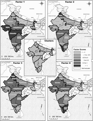
However, the second component (28% of total variance) appears to show signs that the trajectory of the dualistic urban-developmental pattern of Indian states, which associates development with states housing primarily metropolitan or large urban bases, is changing. The positive loadings of the infrastructural (communication, power, and transportation) and human-social development (literacy and per capita income) variables in this component () do not appear to be associated with a particular level of urbanization, contrary to what the notion of dualism would suggest. As revealed in , among the states with the highest positive scores, with the exception of Maharashtra, the urban system of the other three states – namely, Kerala, Punjab, and Haryana – primarily comprised “Medium” and/or “Small” centers. It should be noted, however, that the stereotypical lot of some states on the other end of the spectrum did not seem to change. Those with the highest negative scores (), depicting a high natural increase of population and low infrastructure, net migration and human/social developmental indicators, continued to be the four states of Bihar, Madhya Pradesh (M.P), Rajasthan, and Uttar Pradesh, grouped, as traditionally less developed states, by the acronym BIMARU (meaning “sick” in Hindi) (Bose Citation2001, Citation1991).
Component 3 (14% variance) polarizes the states among those with predominantly medium-sized urban centers (100,000 to 1 million population size group), and those with an amalgam of urban size bases but with a relatively strong service sector as the common characteristic (). Haryana, Punjab, Karnataka, and Rajasthan emerged as states with relatively strong medium-sized urban base, while five states – West Bengal, Kerala, Tamil Nadu, Maharashtra, and Bihar – emerged as states with a weaker urban base of medium centers, but with a stronger service sector as measured by a relatively high proportion of the net domestic product in this sector (). Notably, these latter five states also appear to point towards an emerging pattern that transcends urban size (from Maharashtra, the metropolitan giant, to Kerala, a prime example of a small-city oriented urban system).
Component 4 (12% variance) appears to pick up the association of the “Small” urban centers (population 20,000 to 100,000) with the industrial sector (), and polarizes the states accordingly. It is noteworthy that Maharashtra, one of the most industrialized and urbanized states, with a high level of industrial, social, and infrastructural resources associated with Large or metropolitan centers, emerged as neither associated with industrialization (as per proportion of net domestic products in industrial sector) in the Medium (component 3) nor in the Small centers (component 4). Paradoxically, it showed a commonality with West Bengal, Bihar, and Haryana, states with a divergent array of strengths and weakness, which also seemed relatively deficient in industrialization associated with the Small urban centers ().
Two points can be surmised from the above findings. First, as Components 1, 3, and 4 show, urban size class at different levels appears to show distinct associations with certain developmental traits or indicators: the “Large” or metropolitan cities with FDI, net migration, and proportion of net domestic product (NDP) in the industrial sector; the “Medium” centers with NDP in the service sector (negative); the “Small” centers with the NDP in the industrial sector (positive). These findings, especially in context of the metropolitan states, are not unusual, although the pattern for the Medium centers is harder to explain for us at this point. However, it is worth noting that, contrary to such association of the “economic” development indicators with specific size groups, the “human” developmental variables (in Dimension 2 and their related factor scores) show a pattern that appears to transcend urban size, at least in some of the states.
Based on the factor scores of the four components, we performed a hierarchical cluster analysis ( inset map). The dendrogram results, as presented in , suggest multiple cluster solutions. We have chosen the seven-cluster solution as these clusters appear to be plausible groups conforming to the component analysis results, as well as to our understanding of the traits of the Indian states. Using more condensed cluster solutions would have allowed for broad generalizations to be made about the states contained therein, but the collapsing would have ultimately obscured the salient characteristics of the groups of states. The general characteristics of the seven-cluster solution, including some of the within-group commonalities are offered below:
Cluster 1: (Andhra Pradesh, Karnataka, Gujarat) – Two of these states are spatially contiguous. Good performer on large and medium urban centers; high urban degree, urban agglomerations, and strong foreign direct investment.
Cluster 2: (Bihar, Uttar Pradesh) – Low performer on all or most urbanization and developmental indicators with highest natural increase and out-migration rates. Primarily agricultural, highest in the proportion of net domestic product in the agricultural sector. These states are spatially contiguous; two of the four former BIMARU (“sick”) states. Despite some progress, the two states in this cluster have remained at the bottom of the 13 selected states in most urban and developmental variables.
Cluster 3: (Haryana, Punjab) – Best performer on medium urban centers. Highest in per capita income, second highest in infrastructure index, high literacy; poor performer in the service sector. Spatially contiguous states.
Cluster 4: (Kerala) – Holds a unique position. Compared to the other clusters, best performer on human/social and infrastructural development status: highest literacy rate and infrastructure index, as well as high per capita income; lowest natural increase. Although not an industrialized state with large urban centers, Kerala's proportion of net domestic product in the industrial sector is associated with its small centers.
Cluster 5: (Madhya Pradesh, Rajasthan) – Low performer on the indicators of large economic centers and human development status components. The two spatially contiguous states in this cluster are two of the four former BIMARU states at the lowest level of development. A relatively high proportion of net domestic product in the industrial sector in this cluster is associated with small urban centers, possibly one of the factors related to its emerging divide from the BIMARU states.
Cluster 6: (Maharashtra and West Bengal) – This cluster is at the top or among the top performers on the variables on both of the large economic center and the human development indicators. However, this clustering is relatively hard to explain, because individually, the two spatially non-contiguous states in this cluster are not quite at the same level of urbanization and development, with Maharashtra far ahead of West Bengal in many areas including degree urban, net migration, per capita income, and foreign direct investment. Their commonalities include relatively low proportions of medium and small centers, low proportion of net domestic product in the industrial sector as related to the small centers, and relatively high proportions of the net domestic product in the service sector.
Cluster 7: (Tamil Nadu) – The one-member state in this cluster is characterized by the highest degree of urbanization, highest proportion of population concentration in the “small” centers, and a relatively less robust concentration in the medium centers. It is at or among the top in literacy, per capita income, FDI investment, and infrastructure development. Best performer in the industrial sector among the cluster. Notably, one of the factors contributing towards the uniqueness of this cluster-of-one is the fact that in addition to the relatively common trait of the association of the large centers with net domestic product in industrial sector, the state NDP in Tamil Nadu is also revealed to be associated with its small centers, not a common occurrence among Indian states.
Figure 2. Cluster formation using Ward's method.
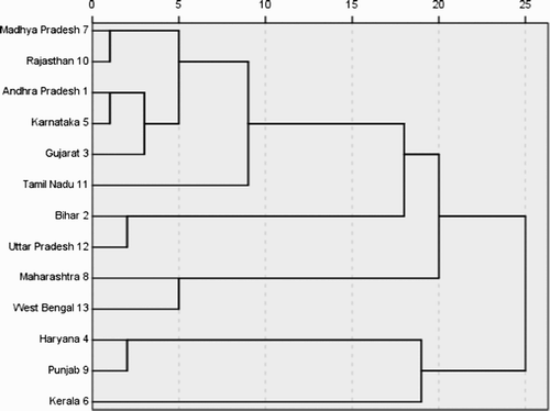
The clustering exercise as presented above serves the purpose of looking at the states beyond the uni-dimensional focus of the components (Large, Medium, Small Centers, and Human Development Status) in the Component Analysis, and helps us surmise a two-fold spatial pattern: one that is less discrete and more spatially diffused across the regions than expected in a dualistic framework, and the second showing more spatial contiguity, in the form of the emergence of contiguous states in the same cluster. States such as Maharashtra and West Bengal in Cluster 6, and Andhra Pradesh and Gujarat in Cluster 1, as well as Clusters 4 and 7 – Kerala and Tamil Nadu, the two single-member “clusters” with distinctive characteristics – are examples of the first pattern, while Clusters 2, 3, and 5 demonstrate the second.
Conclusion
Given the importance of states in India's sociopolitical and economic environment, their relative status, strengths and weaknesses – as well as their commonalities and diversities – have continued relevance and deserve ongoing scrutiny. Our efforts to explore the dualism of the Indian urban growth phenomenon have revealed two concurrent patterns. On one hand, urban-regional dualism is evident in the results of both component and cluster analyses; as the BIMARU states continue to be the worst performers, the best performers hold on to their positions, and about half of the clusters show spatial contiguity. On the other hand, an opposite pattern – that we conceptualize as a relatively “lesser state of dualism” – has also emerged. This second pattern is suggested by several findings: the strong showing of states with a divergent urban base in the human-status dimension; the association of an industrial sector with the “Small” size group; the separation of two of the former BIMARU states from the BIMARU cluster; the spatial distribution and unique single-state standing of some of the clusters. Thus we surmise that while dualism still continues, its trajectory appears to be changing. Our findings on this state-level research, with a limited data set, can be suggestive at best; validation of these observations will require robust research with a comprehensive set of data at different geographical scales. Such empirical research is necessary to build the foundation for new, timely, and context-specific developmental theories, and is also essential for future policy formulations. While theoretical implications are beyond the scope of our study, we hope that our effort will offer a new terrain for launching future research.
Acknowledgement
The authors would like to thank Stephan Freelan, GIS Specialist, Western Washington University, for the final drawing of the map, and Dr. Patrick Buckley, Professor of Geography, for providing helpful comments on an earlier draft. We also thank Dr. Donggen Wang, Editor, and the anonymous reviewers, for valuable comments, which improved this article from its original form. The authors remain responsible for any errors.
Notes
An apt description by Scott and Storper Citation2003, p. 379, to characterize regional economies.
As Lee (in Johnston et al. Citation1994) noted, “the state of development may be defined by such variables… They may also be used to calibrate a scale of development against which comparisons of the level and changes in the level of development within each nation-state may be made” (pp. 128–129).
Census of India 2001 basically defines an Urban Agglomeration as a continuous urban spread with a town or contiguous towns and the adjoining areas.
Class I: Population 100,000 and Over; Class II: 50,000 – 99,999; Class III: 20,000 – 49,999; Class IV: 10,000-19,999; Class V: 5,000-9,999; Class VI: Less than 5,000.
Those workers who had worked for the major part of the reference period (i.e. 6 months or more) are termed “Main Workers” in the Census of India.
This is a minimum distance hierarchical method that calculates the sum of squared Euclidean distances from each case in a cluster to the mean of all variables. This approach maximizes between-group differences and minimizes within-group distances, optimizing the F-statistic, and tends to create clusters of small size (Lattin et al. Citation2003, p. 283).
Related Research Data
References
- Ahluwalia , M. S. 2002 . “ Economic performance of the States in post reform period ” . In Facets of the Indian economy: the NCAER golden jubilee lecture , Edited by: Mohan , R. 215 – 247 . New Delhi : Oxford University Press .
- Banerjee , D. 2010 . Economic and human development in contemporary India , New York : Routledge .
- Banerjee-Guha , S. 1999 . “ Pattern of urbanization and development in India in the 1990s ” . In Urban growth and development in Asia , Edited by: Chapman , G. P , Dutt , A. K. and Bradnock , W. 154 – 162 . Aldershot : Ashgate .
- Bhandari , L. 2006 . The city skyline of India 2006 , New Delhi : Indicus Analytics Private Limited .
- Bose , A. 1991 . Demographic diversity of India: 1991 census , New Delhi : BR Publishing Corporation .
- Bose , A. 1994 . India's urban population , New Delhi : Wheeler Publishing .
- Bose , A. 2001 . India's billion plus people , New Delhi : B.R. Publishing Company .
- Chakravorty , S. 2003 . Industrial location in post-reform India: patterns of inter-regional divergence and intra-regional convergence . The Journal of Development Studies , 40 ( 2 ) : 120 – 152 .
- Chakravorty , S. 2000 . How does structural reform affect regional development? Resolving contradictory theory with evidence from India . Economic Geography , 76 ( 4 ) : 367 – 394 .
- Chakravorty , S. , Koo , J. and Lall , S. V. 2003 . Metropolitan industrial clusters: patterns and progresses . World bank policy research working paper 3073 , : 1 – 35 .
- Chapman , G. P. 1983 . The growth of large cities in India. 1961–1971 . Geoforum , 14 ( 2 ) : 149 – 159 .
- Chapman , G. P. , Dutt , A. K. and Bradnock , W. 1999 . Urban growth and development in Asia , Edited by: Chapman , G. P. , Dutt , A. K. and Bradnock , W. Vol. 1 , Aldershot : Ashgate .
- Chapman , G. P. and Pathak , P. 1999 . “ Indian urbanization and the characteristics of large Indian cities revealed in the 1991 census ” . In Urban growth and development in Asia , Edited by: Chapman , G. P. , Dutt , A. K. and Bradnock , W. 135 – 153 . Aldershot : Ashgate .
- Debroy , B. and Bhandari , L. 2006 . The state of the states . India Today , Special Issue, 18–31
- Guruswamy , M. , Abraham , R. J. and Natarajan , U. 2006 . Socioeconomic security of penninsular India , Chennai : EastWest Books .
- Hust , E. and Mann , M. 2005 . Urbanization and governance in India , New Delhi : Manohor .
- Kant , S. 2004 . “ Regional development in post-reforms India ” . In Reinventing regional development , Edited by: Kant , S. , Singh , N. , Singha , J. and Mukerji , A. B. 229 – 346 . New Delhi : Rawat Publications .
- Kant , S. , Singh , N. , Singha , J. and Mukerji , A. B. 2004 . Reinventing regional development , Edited by: Kant , S. , Singh , N. , Singha , J. and Mukerji , A. B. New Delhi : Rawat Publications .
- Kundu , A. 2002 . “ Institutional innovations for urban infrastructural development: the Indian scenario ” . In Development and cities: essays from development in practice , Edited by: Westendorff , D. and Eade , D. Oxford: Oxfam .
- Kundu , A. 2007 . “ Urbanization and urban governance: search for a perspective beyond neo-liberalism ” . In Indian cities in transition , Edited by: Shaw , A. Chennai : Orient Longman .
- Lahiri-Dutt , K. 2001 . Growth and occupational structures of million cities of India . Asian Geographer , 20 ( 1–2 ) : 153 – 167 .
- Lattin , J. M. , Carroll , J. D. and Green , P. E. 2003 . Analyzing multivariate data , Toronto : Brooks/Cole .
- Lee , R. 1994 . “ Development ” . In The dictionary of human geography , Edited by: Johnston , R. J. , Gregory , D. and Smith , D. M. Hoboken, NJ : Blackwell .
- Misra , H. N. and Chapman , G. P. 1991 . Patterns of growth in India's class I cities . Geoforum , 22 ( 3 ) : 271 – 286 .
- Mohan , R. 2002 . The facets of the Indian economy: the NCAER golden jubilee lectures , India : Oxford University Press .
- Mookherjee , D. 2003 . Differential urbanization model: the case of a developing country, India 1961–1991 . Tijdschrift voor Economische en Sociale Geografie , 94 ( 1 ) : 38 – 48 .
- Mukherji , S. 2001 . Causal linkages between migration, urbanisation and regional disparities in India: required planning strategies , Bombay : International Institute for Population Science .
- Patel , S. and Deb , K. 2006 . Urban studies , New Delhi : Oxford University Press .
- Scott , A. J. and Storper , M. 2003 . Regions, globalization, development . Regional Studies , 37 ( 6–7 ) : 579 – 593 .
- Shaw , A. 2007 . Indian cities in transition , Edited by: Shaw , A. Chennai : Orient Longman .
- Sivaramakrishnan , K. C. , Kundu , A. and Singh , B. N. 2007 . Handbook of urbanization of India , New Delhi : Oxford University Press .