
Abstract
This paper investigates the role of teacher agency for those who were trained in using an innovative Geographic Information Systems (GIS) approach and incorporated GIS into their teaching. While national curricula increasingly emphasise STEM and sustainability approaches, there has been limited analysis of how teachers can bring new software, including GIS, and new approaches into the classroom. Through an evaluation of a teaching initiative “5*S: Space, Surveyors and Students – STEM and the Sustainable Development Goals” designed to bring GIS technology, satellite data, and the Sustainable Development Goals (SDGs) into classrooms as activities and resources for teachers and students in Ireland, we examine how teachers can introduce new teaching strategies and platforms into their classrooms. In interviews and a focus group, teachers expressed eagerness for GIS teaching resources for the classroom and identified effective ways they were able to draw on their own teaching philosophy in introducing new concepts around sustainability and STEM education in the classroom. We argue that teacher agency and autonomy play an important role in the ability and development of teachers, departments, and schools to bring new approaches and GIS into the classroom, and we identify key learnings from teachers who were able to utilise the 5*S resources.
Keywords:
Introduction
New tools are critical to embed the United Nations Sustainable Development Goals (SDGs) in the classroom, an ongoing commitment by the Irish Government in Education for Sustainable Development (ESD) to 2030: Second National Strategy on Education for Sustainable Development (Irish Department of Education, Citation2022). In this paper, we present an exploration of outcomes for teachers who engaged with and expressed an interest in a number of geospatial (i.e. data with location) technologies in their classrooms. These technologies were made available through the design of new and innovative resources and datasets which utilise satellite data to support the delivery of the SDGs. 5*S: Space, Surveyors, and Students—STEM and the Sustainable Development Goals is a teacher-agency based educational project funded by Science Foundation Ireland (SFI) and the European Space Education Research Office Ireland (Esero Ireland). The project’s purpose is to bring space data, particularly earth observation (EO) satellite imagery, and other survey data to secondary school classrooms. 5*S (5 Star S) accomplishes this aim by creating, delivering, and continuously improving resources, workshops, and interactive activities that use Geographical Information Systems (GIS), satellite data, and survey data to connect real-life issues around sustainability and UN SDGs to specific learning outcomes in the Junior Cycle (lower secondary school, abbreviated as JC) curriculum in Ireland.
As one core outcome, we investigated how teachers engaged with 5*S work and content, which brought together new technologies from workplace settings, STEM concepts, and real-world examples and applications. We also analysed how teachers integrated SDGs into their classrooms using 5*S resources and approaches. We used the framework of teacher agency (Biesta, Priestley, & Robinson, Citation2015; Parker, 2015; Wilches, Citation2007) to understand why teachers are interested in developing new teaching material related to SDGs, why they adopted new tools offered by 5*S, and particularly, how they adapted these resources considering their own teaching philosophies and approaches. A qualitative analysis incorporating interviews and a focus group with three teachers who had participated in 5*S training, workshops, and school visits focussed on our three key research questions: (i) why did teachers choose to incorporate GIS and the 5*S content into their classes and how did they use these resources to address national curriculum and SDG requirements?; (ii) how did teachers’ own teaching philosophies inform how they brought new resources into the classroom?; and (iii) what, if any, were the constraints or challenges for teachers using 5*S and other resources in their classrooms?
Research suggests that while GIS-integrated teaching can have a “significantly positive impact compared to conventional teaching methods in enhancing participants’ intrinsic motivation [to study geography]” (Bikar et al., Citation2022), there is an over-emphasis on technical information when training teachers to teach "learning about GIS." This teaching of GIS as Information and Communication Technology results in excessive technical information about the software and datasets (Rød, Larsen, & Nilsen, Citation2010, p. 64). Instead, teachers need resources and support for methodological approaches to integrate "teaching with GIS" into existing lessons and curriculum (Akinyemi, Citation2015; Höhnle, Schubert, & Uphues, Citation2013; Oda, Herman, & Hasan, Citation2020; Roulston, Citation2013). Literature highlights teachers consistently mentioning challenges when teaching GIS including time constraints teaching new software and developing new materials; technical aspects of the software; lack of infrastructure and technical support within schools; and lack of teaching materials and resources in various studies (Höhnle et. al, 2013; Kerski, Demirci, & Milson, Citation2013; Oda et al., Citation2020 Roulston, Citation2013). Höhnle et al. (Citation2013) suggest collaboration among teachers as a strategy to deal with these challenges. There is also potential for collaboration to go beyond single subject teachers (e.g. geography) and involve multi-subject teachers (e.g. science and mathematics) enabling integration of various subject-specific teaching strategies and highlighting the common core elements and skills in the school curriculum (Baker et al., Citation2015; Rød et al., Citation2010). For instance, organising and analysing data, problem solving, and spatial thinking are common skills taught in science and mathematics classes. MaKinster, Trautmann, and Barnett (Citation2013) expand on this in recommending an inquiry-based approach, which is a prominent instructional strategy in science teaching, to “teach using GIS” to construct student-led maps, to make scientific arguments using spatial data, and to identify meaningful patterns in the dataset. Another possible collaboration could be achieved between "real-world experts" and teachers to emphasize the relevance of GIS in understanding today’s global issues through everyday applications (Healy & Walshe, Citation2020).
In this qualitative study using interviews and a focus group with teachers in Ireland who participated in 5*S training and school classroom workshops, we found that teachers participating in 5*S were eager to integrate GIS into their classrooms but wanted and needed confidence in their understanding of the new software and data to integrate new knowledge and approaches into their teaching, informed by their personal teaching philosophy. We also found obstacles to teachers further developing these approaches in the classroom, not least due to the lack of resources caused by the Covid lockdowns of 2020 and 2021; which was the main time period when 5*S workshops and interviews took place. During Covid lockdowns, we observed that teachers were more willing to try new digital teaching approaches, and as in other contexts, found teachers prioritised student well-being and motivation over subject matter (Lepp, Aaviku, Leijen, Pedaste, & Saks, Citation2021). By bringing teachers interested in this approach together in spaces to share their lessons and approaches, especially teachers at different career stages and in different subjects, we were also able to discuss ways of overcoming various structural, practical, and technical obstacles.
In this paper, we first contextualise the national Junior Cycle (JC) curriculum in Ireland and of the current teaching of SDGs at JC level (designed for ages 12–15). We then describe how the 5*S project, and how it aimed to bring new and innovative techniques of satellite observation into the classroom and to make surveying and GIS, as tools to help with achievement of the SDGs, accessible for teachers and students. Secondly, we provide an overview of the theoretical approaches of 5*S in providing resources for teachers to use within their own agency in their schools and in the classrooms and we provide a brief overview of the literature around teacher agency. Thirdly, we describe how we carried out interviews and a focus group, and how we analysed interviews using qualitative coding methodologies in a collaborative robust process within our team—involving expertise from academics in education, in geography, and professionals in surveying and GIS. We found that teachers with interested in integrating SDGs into their classrooms engaged with 5*S using their own personal philosophies of teaching and leveraged new tools, approaches, and datasets in the classroom. We also found that teachers encountered some practical obstacles and conclude the paper with a discussion of possible ways to overcome these and other obstacles.
Educational context in Ireland
In Ireland, 2015 reforms of lower secondary level JC Curriculum (Department of Education and Skills (DES), 2015) reduced the excessive importance of the JC examination, introducing various continuous assessment practices throughout the three years of JC (NCCA, Citation2014). For instance, classroom-based assessments (CBAs) are introduced in different subjects at pre-defined times in a school year, and teachers are critical in encouraging and facilitating students in these tasks (MacPhail, Halbert, & O’Neill, Citation2018). According to Erduran and Dagher (Citation2014), the revised curriculum offers teachers more opportunity to make pedagogical decisions through formative assessments and students have more control over their learning.
Another distinctive feature of the Irish Secondary Education System is the presence of the Transition Year (TY) between JC and Senior Cycle. Nearly 75% of schools offer TY programmes with various options for students to explore their personal and potential future professional interests. These are supported through work placement/apprenticeship experiences, short courses for vocational training, or further academic studies (NCCA, Citation2022).
The final component is a focus on Key Skills in the JC Framework. The eight key skills are linked with learning outcomes for each subject and are intended to guide teaching and student learning (DES, Citation2015). Being numerate, being literate, communicating, being creative, and managing information and thinking are the most relevant key skills identified by the 5*S project. These key skills bridge geography and science subjects, core subjects for 5*S.
The 5*S project
5*S is a Science Foundation Ireland (SFI) Discover project with a main goal of encouraging people of all ages and all walks of life to be informed about, inspired by, and involved in STEM. A specific goal of SFI Discover awards is to reach new audiences not normally engaged with STEM. The 2019 SFI Discover call particularly encouraged projects with a space context, and these were reviewed in association with the European Space Education Resource Office (ESERO) Ireland.
This project aims to support surveyors in connecting with local schools, teachers, and students, with a specific focus towards JC and TY. In this context, surveyors are geospatial professionals (sometimes known as engineering surveyors or geospatial engineers) with expertise in creating, managing, and analysing spatial (location-based) data. The project funds the production of materials (e.g. lesson plans), the training of surveyors, and supports engagement and training of interested teachers through educator-focused workshops. Project staff also directly deliver lesson plans to students in classrooms. 5*S is a collaboration between Maynooth University (Geography and Education Departments), Technological University Dublin (Geospatial Surveying Group), Ordnance Survey Ireland (OSi), Esri Ireland (Environmental Systems Research Institute), and the Society of Chartered Surveyors Ireland (SCSI). The project builds on two existing country-wide school-based programmes to target a national audience: Esri Ireland’s award winning, "ArcGIS for Schools" programme and the SCSI’s "Day in the Life" work-placement programme, which connects a national network of volunteers with existing data/training infrastructure in Irish schools. Esri Ireland provides free software and data to schools across Ireland since 2018 and their cloud-based infrastructure facilitates major outreach schemes including 5*S. The Maynooth University Education Department connects the initiative to student teachers in undergraduate and postgraduate teaching degrees, enabling co-creation of lesson plans tailored for different age-groups.
5*S lesson plans are created using Esri StoryMaps. A StoryMap presents spatial data, maps and other media—text, video, audio and more—to create interactive stand-alone resources built primarily around narratives and story structure. StoryMaps are made within ArcGIS Online, an online platform for GIS developed by Esri. StoryMaps are usually linear; a user usually scrolls through elements from a beginning to an end, and they often include nonlinear elements, such as maps that can be explored and investigated. Various web apps can be integrated into StoryMaps: some of them are developed by Esri within the ArcGIS Online platform including swipe-to-compare features and others; external apps can also be embedded within Storymaps. Each 5*S lesson plan focuses and links at least one spatial dataset, learning objective, and SDG. The plan provides teachers and students with supporting information so that StoryMaps can also be used as a stand-alone resource. Esri StoryMaps can integrate maps, legends, text, photos, and video and advanced web-GIS functionality, all helping to enhance student learning experiences (see for a selection of 5*S StoryMap activities; all the 5*S StoryMaps can be found here: <anonymised>). For example, in one 5*S StoryMap class workshop activity, designed to align with the Irish Junior Cycle Science Curriculum, students learn about and explore a multi-criteria evaluation for identifying possible sites for wind farms in County Cork, Ireland. The activity includes an examination of possible criteria that could be and are used in the evaluation of where wind turbines could be placed, and students virtually explore sites they identify as suitable (see ). This StoryMap activity highlights the application of satellite data in sustainability studies and connects SDG 7 “Affordable and Clean Energy” to science curriculum learning outcomes including to “research different energy sources; formulate and communicate an informed view of ways that current and future energy needs on Earth can be met” (NCCA, Citation2015).
Figure 1. The interactive StoryMapping activity evaluating suitable windfarm locations in Co. Cork, Ireland.
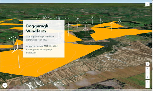
Table 1. A selection of 5*S StoryMap activities and associated subject, SDG and learning outcome from the Irish National Curriculum.
Teachers’ decision making and teacher agency
Some teachers are interested in learning new software, using new forms of spatial data (including satellite data) in their teaching, and collaborating with teachers and researchers from different disciplines. It is worth studying why these teachers have this willingness to learn and implement new strategies in their classes through an exploration of the literature about teacher agency. Agency is associated with the likelihood of taking action. However, agency should be perceived as something beyond personal attributes and relating to how people make decisions and act upon them. Perceptions and past experiences affect how people make decisions and act. In addition to past experiences and present actions, intentions bring about the future aspects of agency that involve being aware of the options and considering the choices in detail (Biesta, Citation2015).
Biesta, Priestly, and Robinson (2015; p.624) define teacher agency as teachers’ "active contribution to shaping their work and conditions," and teacher agency is often associated with feelings of autonomy and teachers’ abilities to take initiative. There is some disagreement about whether teacher agency causes problems or is invaluable and necessary in the complex school system (ibid). Parker (2015) and Wilches (2007) argue that teachers who identified as having more autonomy in their teaching were less likely to experience burn out and/or quit the teaching profession. Salokangas, Wermke, and Harvey (Citation2020) identified links between control regimes within the schooling system and teachers’ decision-making. In curricular regimes focused on student outcomes, including Ireland, there are more control mechanisms for teachers outside of the school through quantitative investigations and high-stakes exams. In these regimes, teachers make decisions "on less important issues" while senior administrators play more important roles in decision-making processes. Salokangas and their colleagues (2019) found that both Irish and Finnish teachers feel independent in their teaching strategies and materials although assessment-related issues still cause some pressure for Irish teachers.
One highly recognized model in teacher agency is the ecological approach proposed by Biesta et al. (Citation2015). This multi-dimensional model includes references to past, present, and future aspects and identifies various factors related to teacher agency. These factors include an iterational dimension including teachers’ life histories and professional histories; a practical-evaluative dimension including teachers’ cultural, structural, and material aspects and resources; and a projective dimension including teachers’ orientation towards the future in some combination of short and long-term objectives. Biesta (Citation2015) highlights the importance of the practical-evaluative dimension in achieving teacher agency. To develop teacher agency, agency should be introduced as an integral part of initial teacher education and professional programmes. Based on the ecological model, however, it should be noted that structures of schooling systems and cultures of schools also play important roles for teachers to achieve agency (Biesta et al., Citation2015).
Teaching SDGs
In 2014, Ireland’s National Strategy on Education for Sustainable Development set goals of ensuring that the education system would contribute to sustainable development and that students in Ireland would “become informed, active citizens who take action for a more sustainable future” (DES, 2014; p.3). This effort has mostly been framed through the UN SDGs, 17 inter-linked global goals designed to be a blueprint to achieve a better and more sustainable future for all. These already feed into many third-level programmes in Ireland (Murphy, Citation2022). The importance of the SDGs at secondary level is less recognized however, despite clear parallels with existing concepts such as "Sustainability" already well-established as a sole strand linked to geography, chemistry, biology, physics, and earth science themes in Junior Cycle Science Syllabus (NCCA, Citation2015).
Sustainability is a complex and nested concept to teach, and the SDGs serve as an effective instructional agenda (Zamora-Polo, Sánchez-Martín, Corrales-Serrano, & Espejo-Antúnez, Citation2019) to help students understand sustainability in different contexts. However, the literature indicates that further research is needed to evaluate how universities prepare student-teachers about SDGs (García-González et al.,, Citation2020) and what teachers know about SDGs (Agirreazkuenaga, Citation2020). Improving how SDGs are embedded in the curriculum and understood by students will also contribute strongly to positive global citizenship, and further recent research on the specific connections between geography education and global citizenship (Al-Maamari, Citation2022). Teaching ideas of "global citizenship" connected to UN SDGs could create meaningful contexts for more integrated global citizenship education taught in different subjects in schools.
The 5*S team identified an opportunity to highlight how spatial data and GIS can be used to meet the SDGs and can become integral in teaching about the SDGs. This effort further enhances work at the international level where the OSi collaborates with the Irish Central Statistics Office and many international peers on the development of 14 Fundamental Geospatial Data Themes. The role of satellite data in sustainability is often overlooked, and 5*S as a project works to communicate the role of satellites and earth observation in helping achieve the SDGs.
Methodology
In evaluating the 5*S project, we took a qualitative approach of semi-structured interviews with three teachers individually, followed by a focus group with the same three teachers together. Participants had experienced either training or classroom workshops by the 5*S team and indicated a willingness to participate in interviews and focus groups. The rationale for combining individual interviews and focus groups with the same individuals lies in increasing the richness and depth of the data. In the current study, we incorporated this methodology for data completeness (Adami & Kiger, Citation2005) by exploring different aspects of ArcGIS experiences through individual lenses and group dynamics.
The individual interviews and the focus group included questions about the ArcGIS workshops attended, previous experience and current practice with GIS, with a special focus on teaching SDGs. Teachers were asked about recent JC curriculum and about enablers and barriers in implementing ArcGIS at their schools. Finally, teachers were asked about teaching SDGs.
The goal of the recruitment of teachers for interviews and focus groups on this project was to speak to teachers who had an interest in bringing the tools and topics of satellites, GIS, and SDGs into their classrooms. Thus, our recruitment methods resulted in participation by some of the most motivated teachers interested in the project. Semi-structured interviews provide a space for the interviewee to answer questions on topics related to the research questions, and for interviewees to expand on questions in ways not previously anticipated by researchers (Lambert & Loiselle, Citation2008; Rosenthal, Citation2016). The teachers had different backgrounds in terms of subjects, teaching experience, exposure to GIS, and different levels of interactions with the 5*S team and content, as summarized in . A focus group prompted interactions between the participants, to deepen the discussion and to explore whether teachers in different contexts were amenable to collaborating with colleagues.
Table 2. Information about participant teachers.
The ethical considerations of the project were explained to the participant teachers before the interviews and focus groups both verbally and with reference to information sheets. Participants gave informed consent regarding their participation in the individual interviews and focus groups. Responses were anonymised and pseudonyms were assigned participants.
An interdisciplinary team of six members carried out a qualitative coding of the transcriptions. Each team member first carried out an exploratory open coding of two transcripts. The team discussed preliminary findings and reflections, and together created a set of closed codes. Each team member then carried out a closed coding of two transcripts so that each transcript was coded four times—twice in open coding, and twice in closed coding - by at least three researchers. This research design allowed for a robust analysis of the key themes and findings from the qualitative dataset.
Results
In the analysis of the interviews and focus groups with teachers involved in the 5*S project, we present our results in three major categories of responses from the teachers using the 5*S approach in the classroom. These three categories were; (i) trends we found in how teachers voiced their integration of technology and SDGs into their classrooms and how 5*S and the GIS teaching materials fitted into their teaching; (ii) the different ways the teachers engaged with 5*S, and how they spoke about their background to inform their engagement with the project and use of teaching materials; and (iii) the obstacles they spoke about when integrating technology and SDGs into their classrooms. Overall, we found that the participant teachers had positive intention to integrate GIS, satellite data, and SDGs into their classrooms and were able to link their own personal philosophies of teaching to use new materials, strategies, and datasets in the classroom.
"Thinking like a scientist" - trends in interviews and focus group
Generally, participant teachers were interested in how new initiatives using technology such as ArcGIS StoryMaps would help students to gain skills in independent learning, critical thinking, and in bringing these skills to the workplace. These are what make up the aspects of teaching for what one participant called "twenty first century learners:"
You do want to kind of help foster independent learning. You do want to create 21st century learners, you want students bring[ing] the skill sets into the workplace that they already have (Jack).
For the participants, the challenge in bringing new initiatives into the classroom was in introducing the new skills at an approachable level for students while connecting the skills to the national JC curriculum and national learning outcomes.
All participant teachers voiced how the 5*S resources were useful in teaching critical thinking and independent thinking skills. All teachers spoke about how they could integrate the 5*S teaching materials and approach into the new learning outcomes and around the key skills identified in the revised JC curriculum. Especially, there was a highlighting of how the GIS approaches provided a way to teach the key skill of "thinking like a scientist," as one participant called it—making calculations and observations, searching for, gathering, and evaluating evidence, and learning about this process in different ways and using different real-world skills. As participant Catherine described it:
At the moment the new Junior Cycle is that it’s not just knowledge based, it’s also very skills acquisition and is [about] thinking like a scientist. And what does a scientist look like? Kids think you know it’s a white coat and you’re in the lab, but it’s not necessarily that. It’s like you said these skills about thinking about the environment, but also thinking about the economy which you mentioned earlier. Thinking about those kinds of implications. But not all scientists wear white coats. (Catherine)
Teaching to "think like a scientist" was particularly apparent when teachers highlighted the "real-world" applications in 5*S activities. Catherine specifically highlighted the 5*S Windfarm activity, described earlier, for how it drew in the students and how it trained teachers about the subject material and its potential as a learning activity:
I think I might pick the wind farm because I think it was just so well told… [A]t the end the kids themselves were drawn in. … You know they’ve driven by wind farms. They’ve probably seen them with friends, and they probably wouldn’t have given it a second thought as to why it’s there. And I think something that they could kind of nearly discover themselves and come up with, you know, a place if they were to decide where you would actually put the windfarm, I think would be really, really good. (Catherine)
In the focus group especially, the three participant teachers discussed the unique interdisciplinary opportunities in the 5*S activities, especially in exploring the role of data in real world activities. Participant Aislinn said:
It’s about making maths real. As well as physics as well as geography really. And then it’s about the ownership of the conflict [regarding climate change] at the end. Then, these students can see we collected these numbers and these numbers actually reflect the impact of climate change on a particular region. (Aislinn)
I think it’s really important to when we’re looking at this is that it’s not just, it doesn’t pertain to one particular area because it hits so many key skills. It can hit so many subjects and that’s the whole purpose of junior cycle… They’re not stand-alone subjects, that you’re learning key skills that are transferable to loads of different areas… GIS really hits that. (Catherine)
Different approaches among participant teachers
The participants also differed in their opinion to parts of 5*S, partly influenced by their background, teaching subjects, and experience. Aislinn and Catherine both spoke to how their experience gave them confidence and ability to experiment with different approaches in the classroom. Catherine spoke about how her teaching experience allowed her to have confidence with the material despite a lack of GIS experience:
I suppose I’m probably the every-man teacher in this field. You know, someone who doesn’t have a lot of experience but will be very much interested in trying to link to the learning outcomes for the junior cycle science…. I think this is where GIS really comes to the fore because you’re kind of ticking off a lot of boxes and a lot of learning outcomes all at once. (Catherine)
Obstacles and challenges
The participant teachers also identified how they thought other teachers would perceive 5*S activities and what obstacles there were to other teachers signing up to 5*S. They identified that most teachers could benefit from 5*S teacher training workshops to use the resources in the classroom for multiple reasons. Aislinn mentioned that “teachers are averse to change [and] don’t like a challenge,” that “teachers need to see the value of something before integrating into your classroom” (Aislinn), and that there was an appetite for collaboration, but teachers are acutely aware of the risks of using a classroom resource that was not effective or that runs into technological problems. In the 5*S project, our close collaboration with Esri Ireland was designed to address this. ArcGIS is a well-established software and has been developed for industry and education since 1999, including the provision of a wide range of supports, especially in educational contexts.
Other obstacles and challenges we found include technical problems with software or use of software in the classroom. These problems included teachers lacking experience in using the GIS and ArcGIS software and issues with the school IT resources and infrastructure, which differed in all three schools.
Discussion
This sample of three teachers provided a view from teachers very interested in bringing GIS and new teaching tools and resources into the classroom to address their curriculum learning outcomes and SDGs. The participants were eager to cooperate—eager to engage with 5*S and to learn and spend time with the ArcGIS Online software to bring satellite content and data into the classroom around themes of SDGs. The teachers identified these elements as very relevant to the key curriculum goals of JC curriculum in Ireland, and that using GIS in the classroom can bring together diverse learning goals and topics: “teaching ArcGIS can always tick more than one box” (Catherine). There is a clear relevance within the Irish geography curriculum for using GIS software including ArcGIS in the classroom, and also a science teacher in the study - with little ArcGIS experience– found relevance and made many connections between the 5*S teaching resources and activities on the science curriculum. Science teachers making these connections is also supported by literature (Gilette, 2015; Hagevik & Stubbs, Citation2011; MaKinster et al., Citation2013).
In their ecological approach to teacher agency, Biesta et al. (Citation2015) referred to past, present, and future aspects of agency. In this study, participants performed different levels of agency including participating in teacher training programmes and supporting students’ participation in workshops.As a science teacher, Catherine was able to make links between use of GIS and the science curriculum with little prior exposure to GIS. She was aware of available options and intended to include GIS in her science classroom, demonstrating agency in the manner indicated by Biesta (Citation2015). Aislinn, with extensive GIS experience, collaborated with a Physics teacher and designed a TY module integrating geography and physics in the ArcGIS platform. In addition, all three teachers also mentioned that they related topics to the and taught the SDGs "in the background." As the SDGs are not clearly defined in the learning outcomes of both the Irish Geography and Science Junior Syllabuses, this also represents a kind of teacher autonomy where teachers synthesize their cognitive interactions with sustainability and the SDGs and integrate them into their teaching practices (Alexandre, Citation2016).
There are limitations to this study. By focusing in-depth with interviews and a focus group on the experiences of a small group of very engaged teachers, we were able to explore and investigate how teachers succeeded in introducing connections between GIS and sustainability to their classrooms. The very different backgrounds of the teachers provided a wide range of viewpoints, with an interesting mix of experience and expertise similar to what is found among groups of teachers at schools. This approach provides important exploratory research, and future research on the emergent themes from this study with larger sample sizes and use quantitative methods could assess the applicability of these finding on a larger scale.
From the results of this study, we argue there should be encouragement for more teacher agency in schools and for teachers to work autonomously. This study also shows that teachers’ ability to bring in new resources and approaches may also be reliant on their ability to use existing resources (Oda et. al, 2020) and infrastructure in their schools; especially, technological limitations such as the availability of a reliable IT infrastructure can limit teachers’ ability to try new approaches. The participants were able to use the resources provided by 5*S to inform their teaching and to accomplish goals that are part of their own teaching philosophy, part of national and school-level priorities, and especially part of integrating SDGs into their teaching. They especially highlighted how their teaching about SDGs happens "in the background" and requires connecting concepts of sustainability and responsibility to existing concepts and subjects in the established curriculum. GIS in the 5*S project teaching approach provides a unique way to make these connections, as real-world spatial data can be used to teach curriculum topics through the lens of sustainability and the SDGs.
Another finding of the study relates to collaboration of teachers at different levels as another indication of teacher agency. There are marked benefits and positive aspects in trying to bring about collaboration and new ways of approaching teaching and curriculum and content, including collaboration at all levels—within departments, across departments, across different schools, and with different institutions. As supported in the literature (Baker et al., Citation2015; Healy & Walshe, Citation2020; Höhnle et al., Citation2013), we found that there were opportunities within curriculum frameworks for different ways of making connections between subjects and bringing GIS tools into the classroom.
The 5*S project provides scope for students to "think like a scientist" and use scientific methods to understand real-world problems, a unifying theme in the revised JC Science Curriculum (Erduran & Dagher, Citation2014). The 5*S lessons provide an opportunity for students to experience "doing science" through spatial data and provide a model for employing the scientific method with spatial thinking. This approach introduces students into GIS through the scientific method, and to the GIS tools that are used in industry and real-life applications. Moreover, inquiry-based teaching was also emphasized by our teachers and is echoed in literature (Bush, Sieber, Seiler, & Chandler, Citation2016; Kerski et al., Citation2013; MaKinster et al., Citation2013; Oda et al., Citation2020).
The contribution in this project explores some ways that approaches to teacher agency can be further developed. Future research could explore the ability of larger groups of teachers to introduce new teaching resources and GIS into their classroom. 5*S engages with more teachers, and it is clear from the findings in this article that further research and engagement with teachers could provide additional insight into how 5*S approaches can best add to teacher agency, providing new and innovating ways teach SDGs and sustainability in the classroom. The interviews and the focus group in this study provided in-depth data, and the study reviews outcomes achieved by teachers who are eager to bring in new and useful approaches and tools into their classroom. It will be important in further studies to gain an understanding of the capabilities and approaches of a larger number of teachers and to examine student perceptions and outcomes for students. Further research could engage with larger groups of teachers and with students around how GIS and 5*S resources can be implemented in the classroom, following up on further preliminary emergent findings, including such concerns as the "learning time" in engaging with GIS software in competition with other demands and pressures from the national curriculum.
Disclosure statement
The authors report there are no competing interests to declare.
Additional information
Funding
References
- Adami, M. F., & Kiger, A. (2005). The use of triangulation for completeness purposes. Nurse Researcher, 12(4), 19–29.
- Agirreazkuenaga, L. (2020). Education for agenda 2030: What direction do we want to take going forward? Sustainability, 12(5), 2035.
- Akinyemi, F. O. (2015). An assessment of GIS use for teaching in Rwandan secondary school. The Geography Teacher, 12(1), 27–40.
- Al-Maamari, S. N. (2022). Developing global citizenship through geography education in Oman: Exploring the perceptions of in-service teachers. International Research in Geographical and Environmental Education, 31(1), 22–37. Available at:
- Alexandre, F. (2016). The standardization of geography teachers’ practices: A journey to self-sustainability and professional identity development. International Research in Geographical and Environmental Education, 25(2), 166–188.
- Baker, T. R., Battersby, S., Bednarz, S. W., Bodzin, A. W., Kolvoord, B., Moore, S., … Uttal, D. (2015). A research agenda for geospatial technologies and learning. Journal of Geography, 114(3), 118–130.
- Biesta, G. (2015). Understanding teacher agency. In Priestley M., Robinson S.(Eds.), Teacher agency: An ecological approach (pp. 19–36). Bloomsbury Academic, an imprint of Bloomsbury Publishing, Plc. London, UK.
- Biesta, G., Priestley, M., & Robinson, S. (2015). The role of beliefs in teacher agency. Teachers and Teaching, 21(6), 624–640.
- Bikar, S. S., Rathakrishnan, B., Rabe, Z., Mahat, H., Sharif, S., & Talin, R. (2022). The impact of geography information system integrated teaching on underachieving students’ intrinsic motivation. International Research in Geographical and Environmental Education, 31(4), 304–319. Available at:
- Bush, D., Sieber, R., Seiler, G., & Chandler, M. (2016). The teaching of anthropogenic climate change and earth science via technology-enabled inquiry education. Journal of Geoscience Education, 64(3), 159–174.
- Department of Education and Skills. (2015). A Framework for Junior Cycle 2015. Dublin: Department of Education and Skills.
- Erduran, S., & Dagher, Z. R. (2014). Regaining focus in Irish Junior Cycle Science: Potential new directions for curriculum and assessment on Nature of Science. Irish Educational Studies, 33(4), 335–350.
- García-González, E., Jiménez-Fontana, R., & Azcárate, P. (2020). Education for sustainability and the sustainable development goals: Pre-service teachers’ perceptions and knowledge. Sustainability, 12(18), 7741.
- Hagevik, R. A., & Stubbs, H. S. (2011). Five steps to success: Implementing geospatial technologies in the science classroom. Journal of Curriculum and Instruction, 5(1), 34–53.
- Healy, G., & Walshe, N. (2020). Real-world geographers and geography students using GIS: Relevance, everyday applications and the development of geographical knowledge. International Research in Geographical and Environmental Education, 29(2), 178–196.
- Höhnle, S., Schubert, J. C., & Uphues, R. (2013). What are the constraints to GIS usage? Selected results of a teacher survey about constraints in the school context. International Research in Geographical and Environmental Education, 22(3), 226–240.
- Irish Department of Education (2022). 2nd National Strategy on Education for Sustainable Development – ESD to 2030. Dublin: DoE.
- Kerski, J. J., Demirci, A., & Milson, A. J. (2013). The global landscape of GIS in secondary education. Journal of Geography, 112(6), 232–247.
- Lambert, S. D., & Loiselle, C. G. (2008). Combining individual interviews and focus groups to enhance data richness. Journal of Advanced Nursing, 62(2), 228–237.
- Lepp, L., Aaviku, T., Leijen, Ä., Pedaste, M., & Saks, K. (2021). Teaching during COVID-19: The Decisions Made in Teaching. Education Sciences, 11(2), 47–68.
- MacPhail, A., Halbert, J., & O’Neill, H. (2018). The development of assessment policy in Ireland: A story of junior cycle reform. Assessment in Education: Principles, Policy & Practice, 25(3), 310–326.
- MaKinster, J., Trautmann, N., & Barnett, M. (Eds.). (2013). Teaching science and investigating environmental issues with geospatial technology: Designing effective professional development for teachers. Springer Netherlands.
- Murphy, R. (2022). Sustainable Development in the Surveying Profession. Society of Chartered Surveyors Ireland. Retrieved on 3rd June from: https://scsi.ie/wp-content/uploads/2022/03/SCSI_SustainableDevelopment_30-03-22_web.pdf.
- National Council for Curriculum and Assessment. (2014). Key Skills of the Junior Certificate. Dublin: NCCA.
- National Council for Curriculum and Assessment. (2015). Junior Cycle Science- Curriculum Specifications. Dublin: NCCA.
- National Council for Curriculum and Assessment. (2022). Transition Year. Retrieved on 1st June from: https://ncca.ie/en/senior-cycle/programmes-and-key-skills/transition-year/.
- Oda, K., Herman, T., & Hasan, A. (2020). Properties and impacts of TPACK-based GIS professional development for in-service teachers. International Research in Geographical and Environmental Education, 29(1), 40–54.
- Rosenthal, M. (2016). Qualitative research methods: Why, when, and how to conduct interviews and focus groups in pharmacy research. Currents in Pharmacy Teaching and Learning, 8(4), 509–516.
- Roulston, S. (2013). GIS in Northern Ireland secondary schools: Mapping where we are now. International Research in Geographical and Environmental Education, 22(1), 41–56.
- Rød, J. K., Larsen, W., & Nilsen, E. (2010). Learning geography with GIS: Integrating GIS into upper secondary school geography curricula. Norsk Geografisk Tidsskrift - Norwegian Journal of Geography, 64(1), 21–35.
- Salokangas, M., Wermke, W., & Harvey, G. (2020). Teachers’ autonomy deconstructed: Irish and Finnish teachers’ perceptions of decision-making and control. European Educational Research Journal, 19(4), 329–350.
- Teaching Council (2020). Céim Standards for Initial Teacher Education. Retrieved 3rd June 2022 from: https://www.teachingcouncil.ie/en/teacher-education/initial-teacher-education/ceim-standards-for-initial-teacher-education/.
- Wilches, J. U. (2007). Teacher autonomy: A critical review of the research and concept beyond applied linguistics. Íkala, Revista De Lenguaje y Cultura, 12(18), 245–275.
- Zamora-Polo, F., Sánchez-Martín, J., Corrales-Serrano, M., & Espejo-Antúnez, L. (2019). What do university students know about sustainable development goals? A realistic approach to the reception of this UN program amongst the youth population. Sustainability, 11(13), 3533.