
Abstract
Maps are spatial representations of environments and are thus inherently geographical. As such, attaining map skills necessitates fostering students’ cartographic- and language-related abilities when using maps, which represent a characteristic role in geography education. However, to our knowledge, there is no empirical research on the cartographic- and language-related abilities required when using maps in geography education classrooms. To gain more profound insights into the linkages between cartographic concept knowledge and language skills regarding maps, a qualitative study among students is conducted. Upper secondary students drew a sketch map using a digital pen of a familiar route in the school area, while simultaneously being recorded thinking aloud. Students’ representations of the cartographic concept in their sketch maps and their cartography-specific/-unspecific language use in think-aloud protocols were analyzed qualitatively. Despite the high heterogeneity within the sample, results show linkages between the cartographic concept representation and cartography-specific language use among the participants. In addition, students who use cartography-specific language at a medium or high level paraphrased less and represented cartographic concepts more appropriately.
Students perceive their everyday home and school environments as interrelated spatial objects and from a particular perspective. This stored spatial information is then organized into conceptual structures as mental representations (Kimerling et al., Citation2016; Rovine & Weisman, Citation1989). Thus, students’ physical experiences in their environment, such as their perceptions and memorizations of spatial objects, scenes, and routes, contribute to the storing of spatial information as a mental map (Saeed, Citation2015; Tversky & Lee, Citation1998). In addition, studies argue that linguistic knowledge is closely connected to stored spatial representations (Halliday, Citation1999), where mental representations of concepts serve as an interface among language, spatial perception, and cognition (Eschenbach et al., Citation1998). Language involves complex mental processes and, in this sense, externalizes the mentally stored representations of knowledge and concepts (Gersmehl & Andrews, Citation1986; Tversky & Lee, Citation1998).
In response, geography education classrooms form the basis for objectifying students’ individual spatial perceptions and mental representations for dealing with them as cartographic concepts on maps. In addition, it is essential to enable students to externalize the knowledge linguistically in a written as well as a spoken format. Thus, it becomes evident that in geography education classrooms, cartographic concepts on a map must be cartographically and linguistically acquired to gain proficiency in map use.
Researching students’ cartographic and language-related abilities when using maps is of utmost importance, as these represent either enablers of or barriers to students’ acquisition of map skills, which are crucial. This is because map skills are regarded as an educational life skill in both the private and public sectors, e.g., the ability to read and use weather forecasts and street and public transportation maps (Kimerling et al., Citation2016). However, empirical studies and data in this research field are lacking. Thus, the overarching aim of this study is to research empirically the link between students’ cartographic concept abilities and cartography-specific language use to develop a more multilayered understanding of learning barriers, as well as to support the needs of students when working with maps. A qualitative research design was thus applied to shed light on students’ cartographic and language-related realizations of cartographic concepts, as well as on the respective linkages, and the study implications include contributing to language-aware map use in geography education classrooms.
Theoretical Framework
According to the aforementioned overarching research topic, the two educational strands concerning maps—the study of maps as either mental or cartographic representations and the study of cartography-specific language use—are conceptualized as follows. These conceptualizations are depicted separately and then combined following the investigation of resulting linkages.
Maps as Mental and Cartographic Representations
From a geographical perspective, maps are graphical representations of environments having varying scales and geographical foci (Kidman & Chang, Citation2023; Kimerling et al., Citation2016). How individuals think about space, act within space, and communicate space entails a cognitive construction that results in the formation of a mental map (Kitchin & Freundschuh, Citation2000; Pinheiro, Citation1998). These mental maps represent a transformation from individuals’ perception of physical space into an abstract representation of stored and decoded spatial information (Uttal & Wellman, Citation1989; Whittington et al., Citation2022). They are not static but dynamic, evolving as individuals gather new experiences and information about their surroundings. Furthermore, these mental maps show how spatial information about environments is processed, structured, and stored (Chiodo, Citation1997; Gärling et al., Citation1986; Richter et al., Citation2012). Each person’s mental map is inherently incomplete and varies significantly based on exposure to environments, personal experiences, social interactions, as well as individual perception, cultural background, and cognitive processes (Gieseking, Citation2013; Kitchin & Freundschuh, Citation2000; Thommen et al., Citation2010). Thus, mental maps reflect a biased nature specific to the inherent subjectivity and distortions each individual possesses (Troffa et al., Citation2009). According to Hemmer et al. (Citation2013), it is necessary to distinguish between respective internal mental spatial representations (mental maps) and external spatial representations on cartographic maps (Bar, Citation1998; Chiodo, Citation1997; Thommen et al., Citation2010; Troffa et al., Citation2009).
Cartographers encode spatial information into cartographic concepts in maps (Bar, Citation1998), the characteristics of which encompass a plan view; a reduced size, including a scale; and generalizations and simplifications of geographical objects using symbols and a legend. In addition, maps can be characterized by the orientation displayed by a system of cardinal directions (Harwood & Usher, Citation1999; Kimerling et al., Citation2016). Thus, the ability to deal with these universal characteristics, present across diverse maps, constitutes a map skill, the attainment of which is a binding duty in the study of geography, as maps represent spatial information. Therefore, students’ acquisition of map skills is included in national and international education standards, creating the basis for geography education curricula (German Geographical Society, Citation2012; Kidman & Chang, Citation2023; Rawling, Citation2022).
Other than decoding, reading, and interpreting maps, map drawing is also considered a map skill (Frank et al., Citation2010; Pétera et al., Citation2016), and it involves externalizing internal representations of spatial information, such as cartographic representations, and it is linked to an individual’s perceptions, storage, and structuring of this information. To draw a map, students must have cartographic abilities, because the spatial information of perceived environments must be encoded as abstract spatial representations. The required awareness of content selection in maps is important, as it includes bias (Pinheiro, Citation1998).
Thus, the products of map drawings in geography classrooms are mostly mental maps or sketch maps if concrete cartographic elements are present. They also involve objectified spatial perceptions with respect to the selection of features and graphic elements (Golledge, Citation1997; Pétera et al., Citation2016). Still, sketch maps are highly individual, predominantly reflecting a subjectively selected collection of spatial content encoded into graphical elements as well (Pinheiro, Citation1998; Troffa et al., Citation2009). Thus, students’ map drawings bear a high diagnostic value, as they represent externalized cartographic knowledge decoded into cartographic concepts (Taketa, Citation1996; Umek, Citation2003). According to Harwood and Usher (Citation1999), concrete cartographic concepts represented in sketch maps and relevant to this study include the representation of the spatial arrangement, scale and proportion, perspective, abstraction and symbolization, and content. These are conceptualized in , forming a holistic illustration of the priorly described basic characteristics of maps and map skills assessable from sketch maps (see ).
These cartographic concepts constitute quality characteristics and must be present as mental representations to be produced on sketch maps. In addition, the respective cartography-specific language is necessary to externalize accurately the knowledge of cartographic concepts and skills in geography classrooms.
Cartography-Specific Language Use
According to Kimerling et al. (Citation2016) and Pinheiro (Citation1998), good map users think in map-like terms. There is a cartography-specific language connected to maps, including a terminology, and it must be explicitly acquired in geography education classrooms. In addition, the process of the graphic encoding and decoding of spatial elements represented on a map is similar to the reading and writing process (Frank et al., Citation2010; Gersmehl & Andrews, Citation1986). According to the PISA study, maps are even categorized as non-continuous texts, with diagrams, tables, and plans contributing to their language-related notion of encoded elements, e.g., graphical elements (OECD, Citation2000).
Generally, subject-specific language in geography education is more complex than everyday language, as it involves lexical diversity, conciseness, and density at the word, sentence, and text levels (Schleppegrell, Citation2004; Snow & Uccelli, Citation2009). With respect to subject-specific language at the word level, such as characteristic terminology, the greater complexity is due to the associated abstract geographical or cartographic concepts that must be cognitively accessed from a subject-specific and linguistic perspective (Schleppegrell, Citation2004; Spires et al., Citation2018). The cartographic concepts in students’ internal representations must thus be translated through their linguistically produced counterparts in the form of cartography-specific language (Denis, Citation1997), where the process of translating conceptual structures and their semantic representations into linguistically accessible production is called microplanning. This constitutes the grammatical and phonological encoding of stored spatial information in the mental lexicon to produce language in form of words (Denis, Citation1997). The interface between cartography-specific concepts and language, especially the terminology used, contributes to more profound insights into the levels of conceptual understanding (Eschenbach et al., Citation1998; Tversky & Lee, Citation1998). Thus, it is of utmost importance to develop a conceptual framework of cartography-specific language at the word level to determine subject-specific terms related to cartography and the cartographic concepts. This would contribute to the investigation of the linkages between students’ conceptual understanding and their cartography-specific language use. Geography teachers must become aware of the mental representations of cartographic concepts through cartography-specific language use to assist properly in overcoming subject-specific or language-related learning barriers when working with maps (Cox et al., Citation2020).
The Encyclopedic Dictionary of Cartography in 25 languages was included to provide a basis for the classification scheme to determine cartography-specific terminology (Neumann, Citation2011). An exemplary selection for cartography-specific terminology is portrayed in to enable a collective understanding of cartography-specific terminology.
Paraphrased cartography-specific terminology was included in the assessment and labelled as cartography-unspecific language.
Following the depiction of the theoretical frameworks, we realize there are evident research desiderata of, first, the conceptual literature on cartography-specific language in particular and, second, empirically researched constructs to measure the linkages between students’ cartographic concept representation and their cartography-specific language use (Spires et al., Citation2018). Thus, the research questions were derived and empirically investigated based on the conceptual frameworks priorly depicted, as follows:
RQ 1: To what extent …
1a: are cartographic concepts represented in sketch maps?
1b: is cartography-specific language use represented in think-aloud protocols?
RQ 2: Are there linkages among cartographic concept production, concept understanding, and cartography-specific language use?
Method
A qualitative research design was applied to students who participated in a think-aloud sketch map research task. As this is the first study to collect empirical data on cartographic concept representations, cartography-specific language use, and their linkages, we developed an explorative, qualitative research design, which will be depicted as follows:
Sample
The sample consists of 10 sketch maps and 548 thought units produced by 10 grade 12 upper secondary students resembling ISCEDFootnote1 III, aged between 17 and 18 years, and who individually participated in the study (UNESCO Institute for Statistics, Citation2012). There was an equal distribution in terms of gender representing the sample, and all students are native speakers, whereas three indicated a mixed background but did not specify their ethnic heritage.
The students were members of the same high school located in Northern Germany, and they attended 90-min geography lessons each week from grade 5 onwards. The participants of the study attended an A-level geography class, and all students followed the same internal school geography curriculum, including the respective textbooks. Due to this being a complex and uncommon task for the students, convenience sampling was applied, and 10 students responded and were all included in the study. The education board, headmaster, respective students, and their guardians officially agreed to the study implementation.
Data Collection
To gain more profound insights into students’ cartographic concept skills and cartography-specific language use, students verbalized their thoughts by thinking aloud while sketching maps (Gilhooly & Green, Citation1996; Scott & Dreher, Citation2016). Numerous studies have proven that sketch maps are a reliable method of collecting data on skills connected to map use (Blades, Citation1990; Rovine & Weisman, Citation1989). The basis of producing sketch maps or map-related tasks is often simplified base maps of 1:5,000 (Thommen et al., Citation2010), whereas thinking aloud is an externalization of participants’ mental concepts and processes while following or engaging in a task (Ericsson & Simon, Citation1998). The participants verbalized their thoughts simultaneously to ensure the highest validity, and both sketching and verbal expressions were recorded simultaneously with the use of a digital penFootnote2. A non-reactive research setting was implemented, so the participants felt comfortable thinking aloud while sketching the map. Participants were only encouraged to verbalize their thoughts if needed (Russo et al., Citation1989).
The process of the empirical study took approximately 1 h and was structured into the following phases:
Participants were orally informed individually of the research process of thinking aloud while sketching a map of a familiar route in the school area. It was broadly mentioned that cognitive- and language-related processes were at the center of the research aim. However, concrete research questions of the study were not explicitly mentioned to reduce bias in the obtained data.
As the task of thinking aloud was unfamiliar to the students, a 2-minute simulation video was shown of a researcher thinking aloud while solving a task independent of sketching a map. In addition to watching the video and answering emerging questions, participants engaged in a practice exercise to think aloud while solving a crossword puzzle.
Then, the participants were given this task in a written format:
Your exchange student from America lives at […] bridge and needs a base map to school:
Draw the route from the […] bridge to the entrance of the school.
Draw an appropriate, subject-specific map with all elements belonging to a map.
Think aloud and say everything that comes to your mind while solving the tasks.
It is important that you speak freely what you think (and not what you do).
Just imagine that you are alone in the room and talk to yourself.
Participants were instructed to use a digital pen and sketch the map on digital paper. Through a connected app, the sketching process was digitalized and stored as video and image. The think-aloud task was simultaneously recorded and stored as sound for the video and individual recording.
The participants indicated when they were finished solving the task and to stop the recording.
Finally, the participants were asked to complete a questionnaire on demographic survey.
Data Analysis
The think-aloud protocols were derived from think-aloud recordings and transcribed according to McLellan et al. (Citation2003). Fine segmentation was applied, structuring the transcripts into thought units based on one strain of thought, and it was mostly completed with a full stop. provides an overview of the participants’ information of their time, units, and words in the think-aloud protocols.
Think-aloud protocols and sketch maps were embedded in MAXQDA 2022 to be analyzed. First, the 10 sketch maps were coded based on the cartographic assessment framework (see ). The cartographic elements in the assessment frameworks concerning the produced sketch maps differ among scholars, and research questions focusing either on map types or rather on detailed abilities related to the production and placement of landmarks, paths, and buildings (Appleyard, Citation1970; Blades, Citation1990; Pétera et al., Citation2016; Rissotto & Tonucci, Citation2002; Rovine & Weisman, Citation1989; Thommen et al., Citation2010). However, in this study, the assessment framework to evaluate the sketch maps of Harwood and Usher (Citation1999) was applied. In Harwood and Usher (Citation1999), the levels of applied accuracy of these cartographic concepts were coded based on a rating scale from zero (= not accurately represented) to five (= fully appropriately represented).
An independent interrater was instructed also to code the sketch maps based on the cartographic assessment framework (see ). We found that the interrater reliability resulted in an agreement of ϰ = 0.94, indicating near-perfect agreement (Brennan & Prediger, Citation1981). The discrepancies could be resolved through discourse, and an agreement could be found. The summarized results were valued into a high (5–4), medium (3–2), and low (1–0) cartographic concept production range. shows an example of an assessment of the cartographic concept abstraction and symbolization in one sketch map.
Then, the think-aloud protocols were analyzed based on the notion of a qualitative content analysis according to Mayring (Citation2014). Therefore, the predefined assessment framework of cartography-specific language (see ) provided the basis for coding cartography-specific language at the word level. Thereafter, the paraphrased cartography-specific terminology in cartography-unspecific language was analyzed, and the concept-driven coding scheme not only enabled the quantification of qualitative data, but it also ensured the transparency, replicability, and objectivity of the analysis (Chi, Citation1997; Gilhooly & Green, Citation1996). Cartography-specific language use was divided into three even-sum ranges based on the highest cartography-specific language use of 69 terms by Student E: high (69–46) medium (45–23), and low (22–0). provides an overview over an exemplary assessment of the cartography-specific language use of Student E.
Above all, a qualitative analysis was included to contribute to a richer and more profound interpretation of the results, particularly those regarding the linkages among cartographic concept representations and their understanding and cartography-specific language use (Patton, Citation2014; Saldana, Citation2021). For this, exemplary phrases of transcript units, including embedded coded cartography-specific language, were provided as quotes.
Results
The students produced 10 sketch maps and 548 thought units in total in the think-aloud protocols. The following section will depict the results and data linkages within the study’s sample, which is an initial approach to contribute to evidence-based insights in this particular research field.
RQ 1a: To what extent are cartographic concepts represented in sketch maps?
provides an overview over the study’s results regarding distinct cartographic concept production on sketch maps. There was great variability in the cartographic concepts accurately produced by participants, and the assessment results of the produced cartographic concepts on the sketch maps display that the participants mainly produced cartographic concepts at a medium or low level.
Perspective, however, was appropriately applied by nine participants, irrespective of their skills related to the production of other cartographic concepts. Meanwhile, spatial arrangement was represented heterogeneously among participants and was either represented at a medium level by six participants or high level by four participants. No participant realized this particular cartographic concept at a low level. The sketch map of Student B (see ), however, shows an exemplary high-range spatial arrangement, including accurate positions of spatial details.
Scale and proportion is another concept represented at a medium level by three participants and mainly at a low level by six participants. Participants were challenged in realizing the reduction of spatial objects in environments, the relation of spatial objects, and an accurate scale. The characteristic feature with regards to scale and proportion, e.g., word scales, which were generally produced by a minority of participants, as only three participants included a word scale, although it was only applied correctly by Student A, who indicated a scale of 1:5,000, as seen in .
Abstraction and symbolization was assessed, resulting in the highest heterogeneity and the highest discrepancy among participants to represent either the spatial information of the familiar route as abstract graphic elements, including a color scheme (∑5 participants), or void abstraction and symbolization production (∑4 participants).
Participants who applied consistent coloring and symbolization schemes in their sketch maps showed greater skill in appropriately producing the respective cartographic concept of abstraction and symbolization. This was further supported by their transparent descriptions of their intuitively developed coloring and symbolization schemes in the included legend, as represented in . Spatial objects, such as bodies of water, trees, green space, and buildings, were each represented as an abstract symbol, including a consistent color scheme produced on the sketch map, as well as the produced legend. Participants lacking symbolization and a color scheme did not include a legend on their sketch map. However, understanding the cartographic concept of abstraction and symbolization necessitates an understanding of how to produce a coherent legend on the sketch map in this sample. In addition, participants with a greater ability to apply this cartographic concept also applied every other cartographic concept either at a high or a medium level.
Content, including additional spatial features on the route map (I) of the task and the wider area (II), were rather less distinctive with a clear majority at the low and medium levels among the participants. The content of the route map and the wider area referred to a set of street names, restaurants, and bus stops on the set route. However, this was the only cartographic concept that has not been represented at a high level by the participants.
RQ 1b: To what extent is cartography-specific language use represented in think-aloud protocols?
portrays cartography-specific and -unspecific language use as a sum, as well as the great variability in the sample results, whereas most of the distribution is concentrated in the medium and low range. In terms of cartography-specific language use, the highest sum is 69 cartography-specific terms used by Student E and the lowest sum of 0 cartography-specific terms used by Student I. Concerning the think-aloud protocols, a significant result is that the total number of uses of the word draw, including drawing (∑35 in think-aloud protocols of 7 participants), and the word map (∑33 in think-aloud protocols of 6 participants) were highest. Furthermore, the cartography-specific nouns legend (∑13 in think-aloud protocols of 5 participants), color (∑6 in think-aloud protocols of 4 participants), word scale (∑6 in think-aloud protocols of 5 participants), and plan view (∑5 in think-aloud protocols of 2 participants) were mentioned a similarly described frequencies. also shows the most frequently reported cartography-specific language. Participants with a high or medium level of cartography-specific language use also showed a higher lexical diversity of cartography-specific language within their think-aloud protocols. Furthermore, this lexical diversity also resulted in the use of distinct cartography-specific language, which differed from most of the terminology in the sample, e.g., bird’s-eye view, three-dimensional, and enlargement by Student E. Meanwhile, greater distinct and exemplary diversity is shown by Student D, including exceptional cartography-specific language use, e.g., outline, to structure, line, lined. Above all, the results highlight a trend that participants who often used cartography-specific language at a high or medium level less frequently paraphrase cartography-specific terminology, as indicated by Students A, C, D, and E.
RQ 2: Are there linkages among cartographic concept production, concept understanding and cartography-specific language use?
is a cross-tabulation illustrating linkages between cartography-specific language use and cartographic concept production within our sample. For instance, in the first column, it is shown that cartography-specific language used at a high, medium, or low level is linked to the cartographic concept of spatial arrangement. Here, as demonstrated, one participant who used cartography-specific language at a high level represented this cartographic concept at a high level as well. An exemplary interpretative analysis of the results is represented in , showing linkages among cartographic concept production, concept understanding, and cartography-specific language use.
Our overall findings indicate that void cartography-specific language use is generally intertwined with a reduced ability to produce cartographic concepts on the sketch maps of participants within the sample. For example, the sketch map of Student H (see Appendix 1) emphasizes this finding, demonstrating an almost void of cartography-specific language and characteristic cartographic concepts, such as the appropriate positions of spatial arrangements; proportion and scale; abstraction and symbolization, including a color scheme; and content on the route and wider area, which are not represented as underlining linkages among participants’ neglect of cartographic concept production, concept understanding, and cartography-specific language use.
Moreover, the results of participants demonstrating a medium or high level of cartography-specific language use produced cartographic concepts resembling a high or medium range. This also shows consistencies between the ability to produce cartographic concepts and to use cartography-specific language in this sample. In particular, these participants, having a high or medium level of cartography-specific language use, have not produced cartographic concepts at a low production level, a finding that can be highlighted regarding cartography-specific language and the cartographic concept of symbolization and abstraction (see ). For instance, the following quote from Student C’s think-aloud protocol emphasizes the appropriate understanding of the concept of abstraction and symbolization, as well as of cartography-specific language use:
Um, and I’m now trying to roughly draw the outlines of the streets, then I’ll produce a legend, um meadows, water, maybe any special features and then maybe draw in buildings and then of course the school, which I’ll then also draw in the legend. […] Let’s keep it simple and symbolic. (Student C)
Within the results of our study, we found one discrepancy in the linkage among cartographic concept use, concept understanding, and cartography-specific language use, especially in linguistic concept realization. While most participants mentioned the term word scale in their think-aloud protocols, only Student A applied it properly on the sketch map (see ).
Discussion
The purpose of this study was to gain a better understanding of upper secondary students’ cartographic concept representations on sketch maps and cartography-specific language use in think-aloud protocols, as well as the linkages among cartographic concept production, concept understanding, and cartography-specific language use. Overall, there are four key findings of the present study. First, participants heterogeneously represented cartographic concepts on sketch maps, except the cartographic concept of perspective, which was applied at a high level. This first finding highlights that most participants could appropriately apply a plan view to their sketch maps, emphasizing participants’ understanding that three-dimensionally perceived and stored spatial information should be represented from a bird’s-eye-view, rather than a side view or pictorial view (Harwood & Usher, Citation1999; Umek, Citation2003). Students’ ability to transition from an internal mental map to a two-dimensional cartographic map strongly aligns with the assumption proposed by Harwood and Usher (Citation1999). It was also demonstrated that there is a rapid transition from side-view to plan-view, which can be attributed to both age progression and culturally based exposure to plan-view maps, such as those found in atlases (German Geographical Society, Citation2012; Rawling, Citation2022). Despite of the fact that the plan view as one component of sketch maps seems universal, its implementation may culturally vary (Harwood & Usher, Citation1999).
Second, participants’ appropriate representation of the cartographic concept abstraction and symbolization at a high level served as an indicator of other cartographic concepts to be represented at a medium or high level. This finding merits comment. It highlights that participants could transfer the perceived, processed, and stored spatial information of the route into a graphic representation. In addition, they could reduce the complexity of detailed spatial features using intuitive symbolizations, visualizing spatial information in a generalized and abstract way to emphasize the predominant universal spatial patterns on a map. Moreover, a consistently applied color scheme added to a characteristic design of a high-level representation of abstraction and symbolization on the sketch maps (Harwood & Usher, Citation1999; Kimerling et al., Citation2016). Participants who had a profound understanding of the respective cartographic concepts also demonstrated greater overall map skills across cartographic concepts, where the transition from an internal mental representation of cartographic concepts encoded into abstraction and symbolization indicated better map skills. While the study’s small sample size prevents us from making broad generalizations, this finding suggests that proficiency in abstraction and symbolization is crucial. Participants in our sample demonstrated that these skills are essential prerequisites for effectively implementing encoded spatial information into maps (Pinheiro, Citation1998; Thommen et al., Citation2010).
Third, cartography-specific language was used heterogeneously, and participants who used cartography-specific language at a medium or high level mainly used less cartography-unspecific language and thus paraphrased less. Participants who used cartography-specific language at a medium or high level paraphrased less, indicating an ability to use more concise cartography-specific language consistently throughout the think-aloud protocol. As cartography-specific terms represent more abstract mentally stored cartographic concepts, these participants showed more advanced and complex cartography-specific language abilities, highlighting that respective abilities contribute to greater subject-specific and, thus, academic language skills at the word level in geography education (Schleppegrell, Citation2004; Snow & Uccelli, Citation2009). In addition, it is noteworthy that these participants exhibited greater lexical diversity in cartography-specific language, coupled with heightened complexity, as well as diversity in their linguistic expressions of mental representations of cartographic concepts. This finding aligns with the existing literature that underscores the interconnectedness between mental and linguistic representations. (Denis, Citation1997; Eschenbach et al., Citation1998).
Fourth, participants who used cartography-specific language in their think-aloud protocols at a medium or high level also represented cartographic concepts on their sketch maps at a medium or high level, indicating linkages among cartographic concept production, concept understanding, and cartography-specific language use, except with respect to the word scale. Our results confirm linkages among cartographic concept production, concept understanding, and cartography-specific language use by the study participants, whose utilization of cartography-specific language at a medium or high level is in accordance with cartographic concept representation at a medium or high level. In particular, participants who verbalized concrete cartographic concepts, e.g., legends, symbols, color schemes, also showed an appropriate cartographic understanding of these concepts and represented the respective concepts correctly on their sketch maps. This finding highlights the linkages between participants’ mental concepts and their linguistic representations, as well as emphasizes that the use of cartography-specific language indicates the depth of participants’ mental encoding of cartographic concepts (Eschenbach et al., Citation1998; Tversky & Lee, Citation1998). This may be explained by the notion of microplanning, as participants translated mentally stored cartographic concepts into a linguistically accessible production of cartography-specific language at the word level (Denis, Citation1997; Dörnyei & Kormos, Citation1998). However, it is also noteworthy that this particular finding does not align with cartography-specific language use of the term word scale, as well as the understanding and correct production of this term. This result underscores that while most participants in the sample recognized the significance of incorporating a scale into their sketch maps and linguistically referenced the term in their think-aloud protocols, they lacked the proficiency to produce the scale correctly. One interpretation of this finding suggests a deficiency in mathematical understanding regarding word scales. Specifically, while most participants attempted to include a scale in the correct format, they often provided incorrect scale values. Taken together, our findings indicate that cartography-specific language use in think-aloud protocols and cartographic concept representation on sketch maps is highly interrelated, as concrete linkages are evident within the underlying study’s sample.
The study provides some first insights into linking the understanding of cartographic concepts and cartography-specific language use, but some limitations concerning the results of this study were encountered. One significant limitation is that the think-aloud map drawing task represents a highly artificial form of qualitative data collection, and this task operates under the assumption that participants can verbalize their thoughts while producing a sketch map. However, it is important to note that students may unintentionally omit information during this process, leading to biases in the data collected (Ericsson & Simon, Citation1998). Furthermore, students’ unfamiliarity with this task format could have contributed to feelings of overwhelm, and the level of cognitive load experienced by participants may have varied, impacting their performance. Despite efforts to reduce this load by thoroughly explaining and practicing the task beforehand, as previously described, the cognitive load remained a limitation of the study. In addition, while the study included upper secondary geography students, who were the oldest students in the school at the time and presumably displayed the maturity necessary to handle the task complexity, this sample does not represent a diverse enough population to generalize the findings. It is conceivable that students with diverse cultural and educational backgrounds or map skill levels may have responded differently to the task. Despite the universality of cartographic concepts across maps, the form of sketch map may vary culturally across different societies. A further limitation pertains to the number of participants, contributing to the notion that the results of this study cannot be generalized. Regardless, they should be considered part of an initial evidence-based exploration that addresses linkages between the understanding of cartographic concepts and cartography-specific language use, which is crucial to language awareness in acquiring map skills within geography education.
Despite these limitations, these results suggest several theoretical and practical implications. Within this sample, our findings underscore the importance of explicitly addressing the cartographic concept of abstraction and symbolization as a prerequisite for decoding encoded spatial information and analyzing a map in geography education, which is crucial for students’ acquisition of map skills. It is imperative for educators to incorporate instructions for translating encoded spatial information and critically evaluating content selection, particularly in light of the potential bias inherent in predominantly Eurocentric map representations, aiming to empower students to discern and resist manipulation (Pinheiro, Citation1998). The creation of sketch maps serves as a valuable tool for students to contemplate their mental organization of spatial information, spatial perceptions, and choices made in content selection and representation, including reflecting on resulting bias. Furthermore, geography educators must recognize the interconnections between the linguistic and conceptual storage of cartographic concepts. Hence, explicit instruction in a cartography-specific language is essential, alongside the teaching of cartographic concepts. This notion of language-aware geography education on a world level regarding maps is crucial for students to articulate the decoded spatial information of maps using precise cartography-specific terminology. Such an approach contributes to more profound map skill acquisition, as proficiency in cartography-specific language is linked to an understanding of cartographic concepts. Furthermore, this fosters an inclusive understanding of geography education, ensuring all students, regardless of their linguistic backgrounds, to acquire both language and concepts related to maps. In terms of future research, expanding on the current findings by investigating larger and more culturally, as well as more linguistically diverse participant samples across various educational levels and societies would be beneficial. This could shed light on potential variations in results concerning students’ cartographic concept representations in sketch maps, as well as linked language use, providing deeper insights into the dynamics of map skill acquisition and contributing towards higher proficiency in geography education.
Although generality among the current results must be established by future research, the present study can be considered a first step toward integrating two lines of research, cartographic concept representation and cartography-specific language use, as, to our knowledge, they have not been directly linked. Our initial evidence from the qualitative content analysis suggests linkages between participants’ use of cartography-specific language and their production of cartographic concepts in sketch maps, underscoring the importance of fostering map skills within a language-aware geography education setting. Thus, our study findings indicate that students’ language use may additionally serve geography teachers as an indicator of cartographic concept knowledge. Finally, the acquisition of map skills in geography education necessitates awareness of the interrelated language. By adopting a language-aware teaching and learning approach, educators can better support students in developing proficiency in map skills and foster inclusive learning environments.
Disclosure statement
No potential conflict of interest was reported by the authors.
Notes
1 International Standard Classification of Education.
2 The digital pen writes like an ordinary pen, but it has an embedded infrared camera and can therefore recognize movements in a fine pattern on the corresponding paper. The production process includes coloring and design possibilities and is automatically digitalized and stored in an app via Bluetooth (Cox et al., Citation2020).
3 Translation from German to English: Maßstab: Word scale.
4 Translation from German to English: Häuser/Gebäude: Buildings, Weg zur Schule: Way to school, Grünfläche: Green space, Bäume: Trees, Gewässer: Bodies of water.
References
- Appleyard, D. (1970). Styles and methods of structuring a city. Environment and Behavior, 2(1), 100–117. https://doi.org/10.1177/001391657000200106
- Bar, S. L. V. (1998). Starting abilities required to learn mapping skills related to physical maps. International Research in Geographical and Environmental Education, 7(1), 50–66. https://doi.org/10.1080/10382049808667558
- Blades, M. (1990). The reliability of data collected from sketch maps. Journal of Environmental Psychology, 10(4), 327–339. https://doi.org/10.1016/S0272-4944(05)80032-5
- Brennan, R. L., & Prediger, D. J. (1981). Coefficient kappa: some uses, misuses, and alternatives. Educational and Psychological Measurement, 41(3), 687–699. https://doi.org/10.1177/001316448104100307
- Chi, M. T. (1997). Quantifying qualitative analyses of verbal data: A practical guide. Journal of the Learning Sciences, 6(3), 271–315. https://doi.org/10.1207/s15327809jls0603_1
- Chiodo, J. J. (1997). Improving the cognitive development of students’ mental maps of the world. Journal of Geography, 96(3), 153–163. https://doi.org/10.1080/00221349708978777
- Cox, M., Elen, J., & Steegen, A. (2020). Fostering students geographic systems thinking by enriching causal diagrams with scale. Results of an intervention study. International Research in Geographical and Environmental Education, 29(2), 112–128. https://doi.org/10.1080/10382046.2019.1661573
- Denis, M. (1997). The description of routes: A cognitive approach to the production of spatial discourse. Current Psychology of Cognition, 16, 409–458.
- Dörnyei, Z., & Kormos, J. (1998). Problem-solving mechanisms IN L2 communication: A psycholinguistic perspective. Studies in Second Language Acquisition, 20(3), 349–385. https://doi.org/10.1017/S0272263198003039
- Ericsson, K. A., & Simon, H. A. (1998). How to study thinking in everyday life: Contrasting think-aloud protocols with descriptions and explanations of thinking. Mind, Culture, and Activity, 5(3), 178–186. https://doi.org/10.1207/s15327884mca0503_3
- Eschenbach, C., Habel, C., Kulik, L., & Leßmöllmann, A. (1998). Shape nouns and shape concepts: A geometry for ‘corner. In C. Freksa, C. Habel & K. F. Wender (Eds.), Spatial Cognition. An Interdisciplinary Approach (pp. 176–202). Springer.
- Frank, F., Obermaier, G., & Raschke, N. (2010). Kompetenz des Kartenzeichnens–Theoretische Grundlagen und Entwurf eines Kompetenzstufenmodells. Zeitschrift Für Geographiedidaktik-ZGD, 38(3), 191–200.
- Gärling, T., Böök, A., & Lindberg, E. (1986). Spatial orientation and wayfinding in the designed environment: a conceptual analysis and some suggestions for postoccupancy evaluation. Journal of Architectural and Planning Research, 3(1), 55–64. http://www.jstor.org/stable/43028787.
- German Geographical Society. (2012). Educational Standards in Geography for the Intermediate School Certificate with sample assignments. https://geographiedidaktik.org/download/educational-standards-in-geography-for-the-intermediate-school-certificate-with-sample-assignments-3-edition-2014/?wpdmdl=821&refresh=6634a653b03cd1714726483.
- Gersmehl, P. J., & Andrews, S. K. (1986). Teaching the language of maps. Journal of Geography, 85(6), 267–270. https://doi.org/10.1080/00221348608979428
- Gieseking, J. J. (2013). Where we go from here: The mental sketch mapping method and its analytic components. Qualitative Inquiry, 19(9), 712–724. https://doi.org/10.1177/1077800413500926
- Gilhooly, K., & Green, C. (1996). Protocol analysis: Theoretical background. Handbook of Qualitative Research Methods for Psychology and the Social Sciences, 14, 43–54.
- Golledge, R. G. (1997). Spatial behavior: A geographic perspective. Guilford Press.
- Halliday, M. A. (1999). The notion of "context" in language education. In M. Ghadessy (Ed.), Text and Context in Functional Linguistics (pp. 1–24). John Benjamin Publishing Company
- Harwood, D., & Usher, M. (1999). Assessing progression in primary children’s map drawing skills. International Research in Geographical and Environmental Education, 8(3), 222–238. https://doi.org/10.1080/10382049908667613
- Hemmer, I., Hemmer, M., Kruschel, K., Neidhardt, E., Obermaier, G., & Uphues, R. (2013). Which children can find a way through a strange town using a streetmap? – results of an empirical study on children’s orientation competence. International Research in Geographical and Environmental Education, 22(1), 23–40. https://doi.org/10.1080/10382046.2012.759436
- Kidman, G., & Chang, C.-H. (2023). Maps and geographical education to encourage the joy of learning for all. International Research in Geographical and Environmental Education, 32(3), 177–180. https://doi.org/10.1080/10382046.2023.2231282
- Kimerling, A. J., Muehrcke, P. C., Muehrcke, J. O., & Muehrcke, P. (2016). Map use: Reading, analysis, interpretation. ESRI Press Academic.
- Kitchin, R., & Freundschuh, S. (2000). Introducing cognitive mapping. In Cognitive mapping: Past, present and future (pp. 9–23). Psychology Press.
- Mayring, P. (2014). Qualitative content analysis: Theoretical foundation, basic procedures and software solution.
- McLellan, E., MacQueen, K. M., & Neidig, J. L. (2003). Beyond the qualitative interview: Data preparation and transcription. Field Methods, 15(1), 63–84. https://doi.org/10.1177/1525822X02239573
- Neumann, J. (2011). Enzyklopädisches Wörterbuch Kartographie in 25 Sprachen. Walter de Gruyter.
- OECD. (2000). Measuring student knowledge and skills: The PISA 2000 assessment of reading, mathematical and scientific literacy. OECD Publishing Paris.
- Patton, M. Q. (2014). Qualitative research & evaluation methods: Integrating theory and practice. Sage publications.
- Pétera, B.-S., Dulamăb, M. E., Ilovanc, O.-R., Kosinszkid, S.-A., & Răcășane, B. S. (2016). Exploring map drawing skills of geography teacher training students. The European Proceedings of Social & Behavioral Sciences, Romania, 12, 41–47. https://doi.org/10.15405/epsbs.2016.12.6
- Pinheiro, J. Q. (1998). Determinants of cognitive maps of the world as expressed in sketch maps. Journal of Environmental Psychology, 18(3), 321–339. https://doi.org/10.1006/jevp.1998.0100
- Rawling, E. (2022). A framework for the school geography curriculum. Geographical Association. https://geography.org.uk/wp-content/uploads/2023/07/GA-Curriculum-Framework-2022-WEB-final.pdf.
- Richter, D., Marin, F., & Decanini, M. M. S. (2012). The sketch maps as a language to analyze geographic reasoning. Procedia Social and Behavioral Sciences, Spain, 46, 5183–5186. https://doi.org/10.1016/j.sbspro.2012.06.405
- Rissotto, A., & Tonucci, F. (2002). Freedom of movement and environmental knowledge in elementary school children. Journal of Environmental Psychology, 22(1-2), 65–77. https://doi.org/10.1006/jevp.2002.0243
- Rovine, M. J., & Weisman, G. D. (1989). Sketch-map variables as predictors of way-finding performance. Journal of Environmental Psychology, 9(3), 217–232. https://doi.org/10.1016/S0272-4944(89)80036-2
- Russo, J. E., Johnson, E. J., & Stephens, D. L. (1989). The validity of verbal protocols. Memory & Cognition, 17(6), 759–769. https://doi.org/10.3758/BF03202637
- Saeed, J. I. (2015). Semantics. John Wiley & Sons.
- Saldana, J. (2021). The coding manual for qualitative researchers. SAGE Publications Ltd.
- Schleppegrell, M. J. (2004). The language of schooling: A functional linguistics perspective. Routledge.
- Scott, D. B., & Dreher, M. J. (2016). Student thinking processes while constructing graphic representations of textbook content: What insights do think-alouds provide? Reading Psychology, 37(2), 286–317. https://doi.org/10.1080/02702711.2015.1052602
- Snow, C. E., & Uccelli, P. (2009). The challenge of academic language. The Cambridge Handbook of Literacy, 112, 112–133. https://doi.org/10.1017/CBO9780511609664.008
- Spires, H. A., Kerkhoff, S. N., Graham, A. C. K., Thompson, I., & Lee, J. K. (2018). Operationalizing and validating disciplinary literacy in secondary education. Reading and Writing, 31(6), 1401–1434. https://doi.org/10.1007/s11145-018-9839-4
- Taketa, R. (1996). Using Field sketch mapping to teach basic mapping concepts in elementary school geography. Journal of Geography, 95(3), 126–130. https://doi.org/10.1080/00221349608978704
- Thommen, E., Avelar, S., Sapin, V. Z., Perrenoud, S., & Malatesta, D. (2010). Mapping the journey from home to school: A study on children’s representation of space. International Research in Geographical and Environmental Education, 19(3), 191–205. https://doi.org/10.1080/10382046.2010.496975
- Troffa, R., Mura, M., Fornara, F., & Caddeo, P. (2009). Cognitive mapping analysis and regional identity. Cognitive Processing, 10 Suppl 2(S2), S328–S330. https://doi.org/10.1007/s10339-009-0306-7
- Tversky, B., & Lee, P. U. (1998). How space structures language. Spatial cognition.
- Umek, M. (2003). A comparison of the effectiveness of drawing maps and reading maps in beginning map teaching. International Research in Geographical and Environmental Education, 12(1), 18–31. https://doi.org/10.1080/10382040308667510
- UNESCO Institute for Statistics. (2012). International standard classification of education ISCED 2011. https://uis.unesco.org/sites/default/files/documents/international-standard-classification-of-education-isced-2011-en.pdf.
- Uttal, D. H., & Wellman, H. M. (1989). Young children’s representation of spatial information acquired from maps. Developmental Psychology, 25(1), 128–138. https://doi.org/10.1037/0012-1649.25.1.128
- Whittington, J. C. R., McCaffary, D., Bakermans, J. J. W., & Behrens, T. E. J. (2022). How to build a cognitive map. Nature Neuroscience, 25(10), 1257–1272. https://doi.org/10.1038/s41593-022-01153-y
Appendix 1.
Sketch Map of Student H
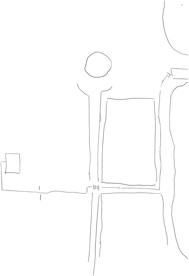
Figure 1. Extract from Word Scale of Sketch MapFootnote3. Source: Student A.
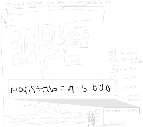
Figure 2. Extract from Legend of Sketch MapFootnote4. Source: Student B.
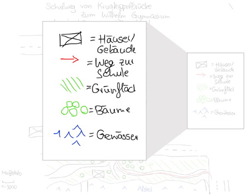
Table 1. Representation of Cartographic Concepts in Sketch Maps.
Table 2. Assessment of Cartography-Specific Language.
Table 3. Overview of the Think-Aloud Protocols of the 10 Participants.
Table 4. Assessment of Sketch Maps.
Table 5. Assessment of the Cartographic Concept Abstraction and Symbolization in an Exemplary Sketch Map (source: Student B).
Table 6. Assessment of Cartography-Specific Language Use in an Exemplary Think-Aloud Protocol.
Table 7. Results of Coding Cartographic Concepts in Sketch Maps of Students (n = 10).
Table 8. Results of Coding Cartography-Specific/-Unspecific Language in Think-Aloud Protocols of Students (n = 10).
Table 9. Frequently reported Cartography-Specific Language (n = 10).
Table 10. Cross-Tabulation of Cartography-Specific Language Use with Cartographic Concept Productions of Students (n = 10).