Abstract
The Colorado River is one of the most highly developed watersheds in the United States and has relatively unique long-term datasets for both recreational visitation and water levels from Lake Mead and Lake Powell, the 2 largest reservoirs in the United States. Previous efforts to model the relationship of recreation and reservoir water levels have primarily relied on survey-based estimates of visitor response to past actual or future hypothetical water levels. We provide the first major reservoir-recreation study based entirely on long-term observed data that also include observed economic impacts. Models of volume and visitation had significant estimated parameters for lake volume explanatory variables, with an R2 of 0.97 for the Lake Powell model and 0.71 for Lake Mead. These models predicted that 100,000 additional acre-feet of water over a year are associated with 5280 additional recreational visits to Lake Powell and 13,490 visits to Lake Mead. A second model of Lake Powell volume and local area tourist spending also had a highly significant volume parameter, with an R2 of 0.91. This model predicted that a 100,000 acre-foot increase in Lake Powell volume over a year is associated with $374,000 in additional visitor spending in tourism-related sectors in Coconino County, Arizona. The Lake Powell volume-visitation and volume-spending models imply the average visitor to Lake Powell spends $71 in lodging, restaurant and bar, and amusement/recreation sectors in Coconino County. This estimate is generally consistent with independent estimates of visitor spending derived from prior National Park Service visitor surveys.
This work presents the case study results of time-series models of Lake Powell and Lake Mead recreational visitation and visitor spending as a function of reservoir volume, based on monthly data. The study contributes to the literature on the use of long-term visitation and water level data using month-level time steps to specifically identify season-level volume–visitation relationships. Additionally, the analysis directly models a reservoir volume–economic activity relationship using observed water volume and local area tax data. Finally, the analysis presents 2 methods of model validation using both within-sample and out-of-sample prediction to assess the predictive power of the estimated models.
Reservoirs serve as popular recreational destinations throughout the United States, providing recreational activities from swimming and boating to fishing and picnicking. Management decisions related to reservoir levels can have a large impact on the attractiveness of a water body for recreation, and predicted effects on water-based recreation are often considered in federal and state agency decisions related to reservoir management (Platt and Munger Citation1999). Reservoirs on the Colorado River, including Lake Powell and Lake Mead, receive millions of visitors every year, most attracted to water-based recreational activities. In recent years, however, a combination of low precipitation years and downstream water delivery obligations has led to reservoir levels at Powell and Mead significantly below historic levels. In the same period of declining reservoir levels, recreational visitation to the 2 National Park Service (NPS) National Recreation Areas (NRA) associated with the reservoirs (Lake Mead NRA, and Glen Canyon NRA for Lake Powell) has also been generally declining. This study explored the statistical relationship between water levels and aggregate recreational use at these 2 Colorado River reservoirs.
Many site-specific estimates of the relationship between recreational use and water levels found in the literature are based on original visitor survey data (e.g., Allen et al. Citation1996, Bergstrom et al. Citation1996, Cameron et al. Citation1996). User surveys have the advantage of flexibility of design, allowing researchers to estimate changes in both participation levels and trip quality associated with changing water levels (Duffield et al. Citation1992). Survey administration is, however, costly and time consuming. Additionally, survey-based models relating water levels to recreation are often based on stated preference responses to hypothetical or past water levels, alone or in combination with short-term actual visitation and water level data (Cameron et al. Citation1996). Eiswerth et al. (Citation2000) used a repeat-contact mail survey of resource users to estimate changes in recreation values associated with declining water levels at a large western lake (Walker Lake, NV) that was drying up. In contrast to most of the literature, Huszar et al. (1999) did not directly survey visitors, but used detailed data collected over a 17-year period by resource managers on reservoir visitor numbers and visitor residency to develop and estimate a joint model of fish catch and recreation demand, both of which depend on water levels, to assess the losses and gains from water-level changes tied to events in the Humboldt River Basin of northern Nevada.
A direct relationship is generally assumed between reservoir levels and recreational use levels (Cordell and Bergstrom Citation1993, Hanson et al. Citation2002, Daugherty et al. Citation2011). Within the Colorado River Basin, Booker and Colby (Citation1995) noted that use of reservoirs is assumed to be a declining function of reservoir area or volume. In another study of reservoir levels in the southwestern United States, Ward and Fiore (1987) estimated changes in visitation across New Mexico reservoir sites as a function of the square root of reservoir area.
Platt and Munger (Citation1999) authored a report for the US Bureau of Reclamation (BOR) reviewing a series of methods for evaluating the effect of changing reservoir water elevations on recreation use and value. Included in this review were suggestions for models based on observed visitation and lake level data. In a follow-up BOR study, Platt (Citation2001) presented a series of use-estimation models developed to address recreational impacts from fluctuating water levels at 2 Kansas reservoirs using available visitation and water level data. The analysis included models of both water-based recreational activities such as boating, fishing, and swimming, and water-associated activities such as picnicking at reservoir sites.
This study utilized a general structure for models to estimate monthly use suggested by Platt and Munger (Citation1999) and applied it to the case of 2 high-profile western reservoirs. The analysis used monthly water volume and recreational use data to fit linear regression models and to assess the predictive power of the fitted models. Additionally, the study used local area monthly tax data and reservoir levels to estimate a linear model explaining changes in tax receipts (visitor spending) as a function of varying reservoir levels. This use of previously collected data on water level, recreational use, and taxes allowed the efficient estimation of marginal effects of alternative reservoir levels on both reservoir visitation and visitor spending.
Unlike models of visitor demand functions (e.g., Weber et al. Citation2012), the water volume–visitation models estimated here are based on aggregate visitation data (e.g., visitors per month) that have no spatial disaggregation. Accordingly, the models demonstrate straightforward statistical relationships between water volume and visitation at the lakes rather than a more comprehensive visitor demand model.
Study sites
This analysis examined 2 national recreation areas administered by the NPS, Glen Canyon NRA (Lake Powell) and, 277 miles downstream, Lake Mead NRA (). Because the relationships estimated in this study are specific to changing reservoir levels and associated recreational use levels, where appropriate, NPS visitation data have been disaggregated to isolate only recreational visitation specific to the target reservoir areas (upstream of Glen Canyon Dam for Lake Powell and Hoover Dam for Lake Mead).
Figure 1 Vicinity map of lakes Mead and Powell and the Colorado River Corridor (color figure available online).
Lake Powell is the second largest man-made reservoir in the United States, behind Lake Mead. On average, it stores about 16 million acre-feet of water, with a maximum capacity of about 26 million acre-feet. It covers about 13% of Glen Canyon NRA, or about 162,500 acres (254 square miles). The dam that holds Lake Powell, Glen Canyon Dam, was completed in 1963, although the lake did not fill completely until 1980. It is 710 feet high, and the hydroelectric power plant within the dam has 1.021 gigawatts of generating capacityFootnote 1 .
The Glen Canyon NRA was established by Congress in 1972, and is run by the NPS. It covers 1.25 million acres (or 1953 square miles)Footnote 2 . In 2011 Glen Canyon NRA received 2.27 million recreational visits (NPS Citation2012). Approximately 175,000 visits were to a short section of the Colorado River downstream of Glen Canyon Dam, and the remaining 2.08 million visits were to the Lake Powell Area upstream of the dam.
Located on the Arizona–Nevada state line, Lake Mead is the largest man-made reservoir, by volume, in the United States. At a lake surface elevation of 1229 feet a.s.l., Lake Mead has the ability to store nearly 29 million acre-feet of water. The reservoir covers 158,500 acres (248 square miles) or about 10% of the Lake Mead NRA. Lake Mead reaches 112 miles up the Colorado River, and when full creates 550 miles of shoreline. Hoover Dam, which creates Lake Mead, was first named Boulder Dam, and then later renamed in 1947. The Boulder Canyon Project-Hoover Dam was completed in 1935 and was the first dam on the Colorado River. Hoover Dam is 726 feet high and 1244 feet long at the crest. The hydroelectric power plant at Hoover Dam has 2.074 gigawatts of generating capacity and provides energy to a wide geographical area in the Southwest.Footnote 3
In 1964, Congress established the first and largest NRA, Lake Mead, administered by the NPS. The Lake Mead NRA covers 1.49 million acres (or 2337 square miles) and also includes the smaller reservoir Lake Mohave. With year-round visitation, it received more than 5 million recreational visits in 2011 (NPS Citation2012).
Table 1 Comparison of characteristics of Lake Powell and Lake Mead.
Table 2 Lake Mead and Lake Powell recreational visitation model explanatory variables (1996–2011 data).
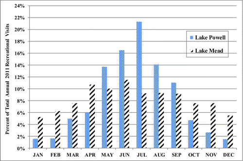
While lakes Mead and Powell are both located on the Colorado River and share many characteristics, there are key differences in the reservoirs and the recreational visitation they receive. Lake Powell at 3700 feet a.s.l. has a full pool elevation 2500 feet above that of Lake Mead (). Accordingly, the mean daily high temperature for Lake Powell is 4.3 C cooler than for Lake Mead. These elevation and climatological differences also manifest themselves in the distribution of recreational reservoir use throughout the year. While the higher, cooler Lake Powell receives more than 50% of its annual use in the summer months of June, July, and August, Lake Mead receives only 30% of its use in these 3 months (; ). Equally important, Lake Mead is much closer to a large population center, Las Vegas, Nevada. A greater share of visits to Lake Mead are 1-day trips, and the proximity to Las Vegas also leads to a more stable use level over the year, while use at the higher elevation, more remote Lake Powell is more concentrated in the summer and shoulder seasons.
Lake visitation and visitor expenditure model methods
The statistical relationship between recreational visitation levels and reservoir volume at the 2 Colorado River reservoirs was modeled through linear regression of time series data on lake use and water volume. The time-step modeled was monthly data, and the period examined was 1996–2011. To estimate participation effect functions for recreational use associated with the reservoirs, 2 primary data series were necessary: data on recreational visitation, and corresponding data on reservoir water levels. Recreational visitation data for the modeling came from NPS visitation statistics (NPS Citation2012), and water level data were drawn from the BOR historical data (USBR Citation2012).
Figure 2 Monthly percentages of 2011 recreational visits to Lake Powell and Lake Mead National Recreation Areas (color figure available online).
Selecting a measure of water level involved choosing between reservoir contents (measured in acre-feet) and surface level of the reservoirs. Visitors to the 2 reservoirs are likely most familiar with levels denominated in surface elevation; however, within the range of data used in the current analysis, surface elevation and reservoir volume were nearly perfectly collinear (e.g., for Lake Powell the 2 metrics had a simple correlation coefficient of 0.9964; for Lake Mead, the correlation was even closer at 0.9979). The nature of the geographical setting of the reservoirs within generally V-shaped canyons suggests that throughout the entire range of possible lake levels there could be significant differences between measurements of surface elevation and volume. Within the data observed over a period of wide variation at both reservoirs and generally declining water levels, however, this relationship was highly collinear, suggesting that no matter which water level reference metric visitors use in making visitation decisions, the 2 alternatives considered are nearly equally suited for modeling the relationship. A sensitivity analysis of alternative specification of the key water-level/volume variable (presented in the results section for the case of Lake Powell) suggests no clear statistical justification for choosing one metric over the other. Within the context of operating the dams, however, downstream water delivery obligations are all denominated in acre-feet of water. To be consistent with this nomenclature, the primary water variable metric used in the following analysis is acre-feet (a.f.) of water held in the reservoirs.
The volume–participation regression model uses time of year and reservoir volume to explain observed variation in recreational visitation. The base linear model was
Scatterplots of monthly visitation by average monthly reservoir contents were initially examined for indications of the functional form for the volume–visitation relationship at each reservoir. In the case of Lake Powell, the plot showed 3 distinct horizontal bands of data points (). Examination of the underlying data showed the observations within the bands were divided into winter month observations (Nov–Mar) in the lowest band, shoulder month (Apr, May, Sep, and Oct) observations in the middle band, and summer month (Jun–Aug) observations in the upper band.
Figure 3 Plot of Glen Canyon NRA visitation by Lake Powell water volume. Monthly data 1996–2011 (simple linear trend lines shown for each series) (color figure available online).
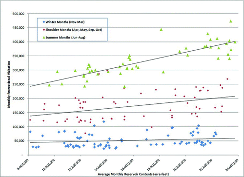
The Powell volume–visitation plot () also shows simple linear trendlines for the 3 horizontal data bands, which suggest that summer visitation is more responsive to changing reservoir levels than shoulder season or winter season visitation. Based on this result, the model for Lake Powell was estimated by regressing monthly recreational visitation on indicator variables for the months March through November, average monthly reservoir volume (a.f.), and interaction terms for volume in the core summer months and in the shoulder season ().
In the case of Lake Powell, separate models were estimated for data from 1996 to 2006, and from 1996 to 2011 to check for stability in the estimated parameters. Additionally, the 1996–2006 model was used to predict out-of-sample visitation for the period 2007–2011, and these predictions were compared to actual observed visitation levels.
The volume–visitation plot for Lake Mead (1996–2011) indicates that while there is some level of banding of data points by season, as was clear in the Powell plot, the distinction between seasons is much less clear (). The large degree of overlap between the summer and shoulder season observations is consistent with Lake Mead visitation being much more evenly distributed across the year than in the case of Powell. For Lake Mead, monthly (1996–2011) recreational visitation was also regressed on month indicator variables (Mar–Nov), monthly volume, and summer and shoulder season interaction terms.
The Lake Powell volume–expenditure model used time of year and volume along with explanatory variables for an annual trend and monthly unemployment rate (as a measure of general economic vitality) to explain observed variation in monthly gross sales in Coconino County, Arizona, for several key tourism-related sectors. An additional explanatory variable in the model is monthly recreational visitation to Grand Canyon National Park (NP), the largest single driver of tourism spending within Coconino County (NAU Citation2005). As such, inclusion of the NP visits within the model provides a more complete representation of the key drivers of tourism spending within the county. Inclusion of this variable also reduces the chance of the Lake Powell water variable capturing some share of omitted variable bias. The functional form of the estimated expenditure–volume relationship is identical to that specified in Equationequation 1, where ![]() . is estimated visitor spending for month, and i; x
i1, …, xiK
. are the time of year, reservoir volume, Grand Canyon NP visitation, annual trend, and national unemployment rate for month i.
. is estimated visitor spending for month, and i; x
i1, …, xiK
. are the time of year, reservoir volume, Grand Canyon NP visitation, annual trend, and national unemployment rate for month i.
Results
Estimated lake visitation model
The estimated parameters were reported for linear regression models explaining Lake Powell and Lake Mead monthly recreational visitation as a function of reservoir volume and monthly indicator and interaction variables (). The models here utilize lake volume (a.f.) as the primary explanatory variable. The estimated R2 statistics show the Lake Powell models as specified explain approximately 97–99% of the variation in observed visitation. Models for the 1996–2006 period and the 1996–2011 period demonstrate the stability of the VOLUME parameters over time periods. All parameters in the 2 models remained significant in the extended dataset, parameter values remained highly stable, and all variables have the expected sign. The key variables and coefficients for explaining the relationship between changing lake levels and changing visitation are the VOLUME, SUMMER*VOLUME interaction, and SHOULDER*VOLUME interaction variables. The coefficient on Lake Powell VOLUME (0.00116) indicates that throughout the year there is a positive statistically significant relationship between water volume and visitation. This coefficient indicates that for every 100,000 a.f. of additional water volume in Lake Powell there are an associated 116 additional recreational visits per month to the reservoir (). The marginal change of 100,000 a.f. of storage is used for computational convenience in demonstrating marginal effects. For both the Lake Powell and Lake Mead data, 100,000 a.f. represents (on average) a bit less than a foot of reservoir storage (10.3 inches at Powell and 9.3 inches at Mead). This marginal unit is used not to suggest visitation decisions would necessarily be based on a change of 100,000 a.f., but to illustrate the average demonstrated responsiveness to changes of this level within the entire data time series.
Table 3 Estimated Lake Powell and Lake Mead recreational visitation models.
Figure 4 Plot of Lake Mead NRA visitation by Lake Mead water volume. Monthly data 1996–2011 (simple linear trend line shown) (color figure available online).
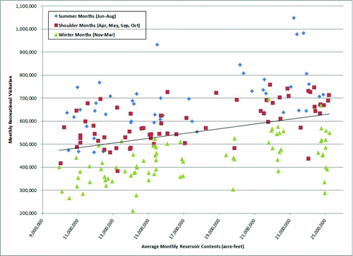
Table 4 Estimated marginal impact of reservoir elevation changes, Lake Powell.
The other water level variables, SUMMER*VOLUME representing levels in June–August, and SHOULDER* VOLUME representing levels in April–May and September–October, are highly statistically significant (at the 99% level of confidence). The Lake Powell (1996–2011) SHOULDER*VOLUME coefficient (0.003) indicates that during the 4 shoulder season months, 100,000 a.f. of storage is associated with an additional 300 visits per month. This effect is additive to the baseline effect relationship indicated by the VOLUME coefficient. The SUMMER*VOLUME coefficient (0.00895) shows that during the June–August period, an additional 100,000 a.f. of Lake Powell storage is associated with an additional 895 recreational visitors per month ().
Overall, the Lake Powell model provides a statistically significant estimate of the marginal impact of varying lake levels on visits. As would be generally expected, the greatest impact is found in the high-use summer months. The shoulder season showed the next largest marginal impact, and the winter season a smaller marginal impact (). Within the range of data used, an additional 100,000 a.f. of water in Lake Powell over an entire year would be associated with an increase in recreational visitation to Glen Canyon NRA of 5280 visits.
In addition to the explanatory variables (), other variables were modeled for both reservoir datasets, including monthly regional gasoline prices, an indicator variable for months in which the US economy was in official recession, an indicator variable for months beginning in January 2008 (to test for a significant structural change in the nature of the volume–visitation relationships from before to after the onset of the “great recession”), and indicator variables for critical lake levels that impact visitor use (such as the lake level at which the Lake Powell “Castle Rock Cut” becomes passable, or the level at which the Hite Marina access [now closed] was accessible).
While models including only reservoir volume or only a critical-level indicator variable were individually significant, models including both variables were not. The 2 models can be viewed as alternative ways of modeling use. The explanatory models presented () describe marginal changes in visitation throughout the full range of observed lake levels, while a model including only indicator variables for the critical lake levels describes a step function showing only 2 water level-dependent levels of visitation. The continuous model had more explanatory power and general applicability. The additional variable, regional fuel price, was not statistically significant. Additionally, none of the indicator variables for recession months or pre- and post-onset of the “great recession” were statistically significant.
Within the literature, most studies utilize lake elevation rather than volume (a.f.) as a measure of water level (e.g., Jakus et al. Citation2000, Hansen et al. Citation2002). As noted, the correlation between surface elevation and water volume for both Mead and Powell is nearly perfect (r = 0.9964 at Powell, and r = 0.9979 at Mead). Were the correlations perfect (r = 1.0), the choice of an appropriate metric would be irrelevant, and akin to choosing between measuring land area in acres or hectares. Despite the close correlation, as a test of sensitivity to the choice of water measures, a model for the reservoir with the lower correlation (Lake Powell) was reestimated using surface elevation for the key water variables. A comparison between the key estimated water variable parameters under the 2 measurement metrics () shows that, as expected given the high correlation, the implied marginal changes in visitation associated with an average 1-foot change in reservoir level is very close between the 2 models. The R2 statistics are identical, and parameters are significant at the same general levels of significance. These results provide no clear basis for choosing one specification over the other.
Table 5 Comparison of Lake Powell recreational visitation models between alternative specifications of the key reservoir volume/level variables.
Figure 5 Out-of-sample predictions of monthly Lake Powell visitation, 2007–2011, based on model fitted to 1995–2006 data (color figure available online).
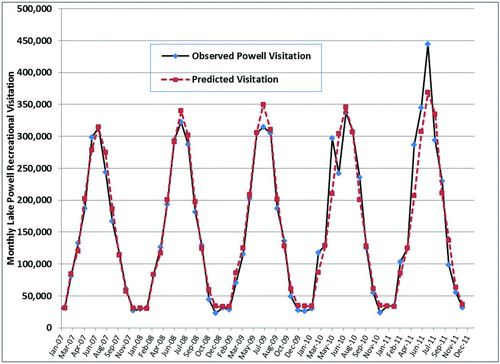
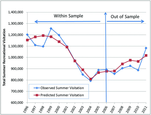
Figure 6 Lake Powell summer season average volume and total visitation. Within and out-of-sample predictions vs. observed (color figure available online).
The Colorado River is managed and operated under numerous compacts, federal laws, court decisions and decrees, contracts, and regulatory guidelines collectively known as the “Law of the River” (USBR Citation2005). This collection of decisions and agreements apportion the water and regulate the use and management of the Colorado River among the 7 basin states and Mexico. Downstream water delivery obligations that constrain the operation of both Glen Canyon and Hoover Dams are denominated in acre-feet of water (rather than as surface elevations of the reservoirs); however, management of the reservoirs is often determined by lake elevation. The closing of boat ramps, movement of marinas, and drinking water withdrawal structures are all local policy decisions based on elevation, not volume. A key consideration of the choice of a water metric in our models was cross-site comparability. While an acre-foot of water is consistent across sites (not only Mead and Powell, but across hundreds of reservoirs and lakes in the US), a foot of elevation implies vastly different volumes of water at different sites. Because water in the Western United States is generally sold, leased, and measured in acre-feet or acre-feet equivalents, the models and results reported here also denominate marginal water impacts in changes per acre-foot to be consistent with other uses and sites.
Table 6 Coconino County, NM tourism sales model explanatory variables.
As discussed, the observed volume–visitation plot for Lake Mead suggested that distinct summer season and shoulder season relationships were not obviously present in the data (as was the case for the Lake Powell observations). A specification for Lake Mead that included summer and shoulder season interaction terms showed these terms were not statistically significant while the simple VOLUME term was highly statistically significant (). A reduced specification of the Lake Mead model without the interaction terms showed a stable and significant VOLUME term. This Lake Mead reduced model implies that an additional 100,000 a.f. of volume is associated with 1124 additional recreational visits per month, or 13,490 visits over the entire year ().
The time-series nature of the reservoir volume–visitation data and associated models was tested for the presence of autocorrelation of residuals. When model residuals are serially correlated, the ordinary least squares estimator is still unbiased, but not efficient. Both the Mead and Powell volume–visitation models showed marginal but statistically significant first-order autocorrelation. Correcting for this serial correlation with an autoregressive error model resulted in model fits and parameter estimates that were virtually unchanged in magnitude, and parameter t-values that were still highly statistically significant (at the 95% level of confidence or higher). Based on the stability of the models, the untransformed estimates are presented.
Table 7 Estimated Coconino County, NM tourism sales model.
Estimated visitation model predictive power
Two tests of the predictive power of the estimated volume–participation models were conducted. For both the Lake Powell and Lake Mead models, observed monthly recreational visitation was compared to the 95% prediction intervals for the individual monthly data points. For Lake Powell, only 5 of the 192 observations fell outside the 95% prediction interval; in the Lake Mead model, 8 of 192 observations fell outside the prediction interval. A second predictive test, an out-of-sample test, was applied to the Lake Powell model. The model was estimated on only two-thirds of the available data (1996–2006), and this model was used to predict visitation using observed 2007–2011 reservoir levels. In 11 of the 60 out-of-sample months (18.3% of observations), the model predicted recreational use levels outside the 95% prediction interval. The plot of observed recreational visitation and out-of-sample predictions for 2007–2011 () shows the variation in visitation levels across months is dominated by seasonally driven changes in visits. An example of predictions versus observations for the aggregated summer months (Jun–Aug) was controlled for seasonal variation (), and thus all predicted changes in visitation were driven by changes in average lake volume for the 3 months. Clearly, the model predictions track closely to actual observed participation levels both within- and out-of-sample.
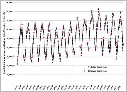
Figure 7 Coconino County, NM, predicted vs. observed gross sales based on Lake Powell average volume from 1997 to 2011 (sales in tourism-related sectors in 2011 $) (color figure available online).
Model of lake level: visitor expenditure impacts
Changes in recreational visitation to lakes and reservoirs do not occur in a social and economic vacuum; they may have significant regional economic impacts. Visitors to lakes and reservoirs within NPS units spend money within the local economy, which drives park-related effects on gateway communities (Stynes et al. Citation2000). Prior work on this issue has been largely based on survey methods used to measure visitor expenditures. We introduce an estimate of recreational visitor expenditure impacts based on a direct link between water levels and visitor spending as measured through taxes on tourism-related spending.
The visitor expenditure impact of varying Lake Powell water levels was estimated by comparing monthly gross tourism-related sales (M. Bradford, Northern Arizona University, 30 Nov 2012, pers. comm.) reported in Coconino County from January 1997 to December 2011 (2011 $) to average monthly Lake Powell storage. Amusement, restaurant and bar, and hotel/motel sales, as reported by the county from tax receipts, were aggregated for this analysis () and were used in the regression (). The results show a highly significant estimated coefficient on Lake Powell volume, implying a 100,000 a.f. increase in storage in Lake Powell leads to an increase in Coconino County sales of $31,200 (2011 $) per month, or $374,000 per year. The highly significant estimated coefficient for Grand Canyon NP visitation implies that each visitor to Grand Canyon NP spends $73.41 on lodging, restaurant and bar, and amusement services within Coconino County. These results are generally consistent with independent estimates of Grand Canyon visitor spending in the county by Northern Arizona University (NAU Citation2005). The model also shows highly significant shoulder season effects, a significant positive annual trend, and an expected negative (and highly significant) effect of the average monthly unemployment rate on gross sales (, ). The model has an R2 of 0.912.
On average, a 100,000 a.f. increase in Lake Powell water levels would lead to an increase in recreational visitation to Lake Powell of 5280 visits (), and a 100,000 a.f. increase over a year in Lake Powell would be associated with an additional $374,000 spent in Coconino County on lodging, restaurant and bar, and amusement and recreation spending (). These models imply that an average visitor to Lake Powell spends $70.90 in these spending categories within Coconino County. In 2007, the NPS Visitor Services Program (Holmes et al. Citation2008) surveyed Glen Canyon NRA visitors and estimated that spring visitors spend about $102 (2011 $) per visitor for lodging, restaurant and bar, and recreation or amusement, and summer visitors spend an average of $118 in these categories. The NPS survey estimate of $102–$118 per visitor included some spending that occurred outside of Coconino County. The implied spending per visitor from the model of $70.90 () is appropriately smaller, yet in the general range of the Holmes et al. estimate. Additionally, the model expenditure implications for Lake Powell visitors (at $70.90) and Grand Canyon NP visitors (at $73.41) show consistency.
Only a small portion of Lake Powell (and the adjacent community of Page, AZ) lies within Coconino County (); however, this is the most commercially developed section of Lake Powell. While Lake Powell visitor spending represents a minor segment of total tourism-related spending within Coconino County, the estimated statistical relationship between Lake Powell volume and visitor spending shown in the model is strong, underscoring the robust nature of models based on long term consistently collected time series data.
Conclusions
Estimating the marginal impacts—both to recreational visitation and to visitor spending—of changing reservoir levels is more than an academic exercise. Agencies such as the BOR and Army Corps of Engineers have played a large role in dam building in the United States and routinely consider effects on recreation in reservoir management decisions (e.g., Platt and Munger Citation1999, Allen et al. Citation2010). Given the cost and sometimes infeasible time constraints required to conduct original visitor survey research for every reservoir management decision, the ability to obtain robust estimates of recreational impacts from data already collected and organized provides managers with an additional tool for analysis and decision making. Additionally, because our revealed preference models are based entirely on long-term observed data, they may have greater credibility with managers. A limitation of visitor survey data is the possible introduction of nonresponse bias, given the impossibility of obtaining 100% response rates. Further, surveys are often administered over a relatively short time period (weeks or months) and may not be entirely representative of a full year or of the long term.
The combination of BOR-managed reservoirs and NPS-administered recreation areas provides a data-rich opportunity to estimate models for marginal effects of changing water levels in the cases of Lake Powell and Lake Mead. The BOR maintains daily data on reservoir contents, and the NPS reports detailed monthly visitation estimates. All these data are readily available online (NPS Citation2012, USBR Citation2012). The case studies of Lake Powell and Lake Mead were made even more interesting by large variation in reservoir levels over recent years. Over the study period, both reservoirs had generally consistently declining average annual water levels. The combination of these factors facilitated the estimation of highly explanatory and statistically robust models of both recreational visitation and visitor spending as a function of reservoir levels at these the 2 largest man-made reservoirs in the United States.
While both the visitation and expenditure models presented provide valuable predictions of the impacts of varying reservoir levels at lakes Mead and Powell on recreational visitation and visitor spending, current contractual responsibilities for downstream water deliveries may severely limit the latitude of reservoir managers to consider these visitor-based impacts in reservoir management decisions. As a fully appropriated system tightly controlled by the existing Law of the River, recognizing significant ties between water levels and recreational use and spending does not necessarily imply that these factors could be considered fully within current reservoir management constraints.
This analysis is a case study demonstration of the feasibility of using existing data to estimate water level-participation models, or even water level-visitor expenditure models. The estimates perform well in terms of statistical significance, both within- and out-of-sample predictive power, as well as in terms of consistency with independent visitor expenditure estimates derived from visitor surveys. These results provide encouragement for expanding and employing this method of analysis at other sites with similar data availability. The Colorado River corridor itself has a number of similar sites, but any site with consistent time series data associated with water levels and visitation or local-area tourism-related spending is a potential candidate. Where data allow, the models provide an extremely efficient alternative to costly and time-consuming visitor surveys for estimating key water level-related parameters.
For the sake of brevity and focus, this analysis was limited to demonstrating the underlying empirical relationships in the visitation-lake level data. A natural extension of the results for Lakes Mead and Powell would be to analyze the different policy implications of alternative reservoir management scenarios at the 2 sites in terms of regional economics or consumer surplus. Further extensions could include impacts on hydroelectric production values at the 2 dams.
Acknowledgments
Primary funding for this research was a grant from the National Park Service Social Science Program. The study benefited substantially from comments on a draft report by Dr. Bruce Peacock. Significant assistance in data collection, analysis, and organization was given by Amy Harvey and Joel Dalenberg. The paper benefited significantly from the comments and suggestions of 3 anonymous reviewers. Any remaining errors or omissions are solely the responsibility of the authors.
Notes
Statistics from www.USBR.gov/projects/Facility.jsp?fac_Name=Glen Canyon Dam. Accessed 12 July 2013.
NPS.gov/glca/naturescience/index.htm. Accessed 12 July 2013.
Statistics from, USBR.gov/projects/Project.jsp?proj_Name=Bo ulder±Canyon±Project±-±Hoover±Dam. Accessed 12 July 2013.
References
- Allen , D S , Jackson , R S and Perr , A . 1996 . Alabama-Coosa and Alabama Chattahoochee-Flint comprehensive study: draft report , Vicksburg , (MS) : US Army Engineer Waterways Experiment Station .
- Allen , J S , Carey , R T , Dickes , L A , Saltzman , E W and Allen , C N . 2010 . An economic analysis of low water levels in Harwell Lake: final report , Clemson , (SC) : US Army Corps of Engineers Savannah District .
- Bergstrom , J C , Teasley , R J , Cordell , H K , Souter , R and English , D B . 1996 . Effects of reservoir aquatic plant management on recreational expenditures and regional economic activity . J Agric Appl Econ. , 28 : 409 – 422 .
- Booker , J F and Colby , B G . 1995 . Competing water uses in the southwestern United States: valuing drought damages . Water Resour Bull. , 31 ( 5 ) : 877 – 888 .
- Cameron , T A , Shaw , W D , Ragland , S E , Callaway , J M and Keefe , S . 1996 . Using actual and contingent behavior data with differing levels of time aggregation to model recreation demand . J Agric Resour Econ. , 21 ( 1 ) : 130 – 149 .
- Cordell , H K and Bergstrom , J C . 1993 . Comparison of recreation use values among alternative reservoir water level management scenarios . Water Resour Res. , 29 : 247 – 258 .
- Daugherty , D , Buckmeier , D and Kokkanti , P . 2011 . Sensitivity of recreational access to reservoir water level variation: an approach to identify future access needs in reservoirs . American Journal of Fisheries Management , 31 : 63 – 69 .
- Duffield , J , Neher , C and Brown , T . 1992 . Recreation benefits of instream flow: application to Montana's Big Hole and Bitterroot Rivers . Water Resour Res. , 28 ( 9 ) : 2169 – 2181 .
- Eiswerth , M E , Englin , J , Fadali , E and Shaw , W D . 2000 . The value of water levels in water-based recreation—a pooled revealed preference/contingent behavior model . Water Resour Res. , 36 ( 4 ) : 1079 – 1086 .
- Hanson , T R , Hatch , U and Clonts , K C . 2002 . Reservoir water level impacts on recreation, property, and nonuser values . J Am Water Resour Assoc. , 38 : 1007 – 1018 .
- Holmes , N C , Manni , M , Eury , D and Hollenhorst , S . 2008 . Glen Canyon National Recreation Area visitor study: spring and summer 2007 , 186 Moscow , (ID) : Park Studies Unit Visitor Services Project Report .
- Huszar , E , Shaw , D W , Englin , J and Netusil , N . 1999 . Recreational damages from reservoir storage level changes . Water Resour Res. , 35 ( 11 ) : 3489 – 3494 .
- Jakus , P , Dowell , P and Murray , N . 2000 . The effect of fluctuating water levels on reservoir fishing . J Agric Resour Econ. , 25 ( 2 ) : 520 – 532 .
- [NAU]. Northern Arizona University . 2005 . Grand Canyon National Park Northern Arizona Tourism Study. Arizona Hospitality Research and Resource Center , Flagstaff , (AZ) : Northern Arizona University, School of Hotel and Restaurant Management .
- [NPS] National Park Service . 2012 . Visitor use statistics; [cited 15 Oct 2012] . Available from: https://irma.nps.gov/stats
- Platt , J. 2001 . Reservoir recreation use estimation modeling with water level fluctuation , Denver , (CO) : Bureau of Reclamation, Technical Service Center .
- Platt , J and Munger , D . 1999 . Impact of fluctuating reservoir elevation on recreation use and value , Denver , (CO) : Bureau of Reclamation, Technical Service Center .
- Stynes , D , Propst , D , Chang , W and Sun , Y . 2000 . Estimating regional economic impacts of park visitor spending: money generation model version 2 (MGM2) , East Lansing , (MI) : Michigan State University, Department of Parks, Recreation and Tourism Resources .
- [USBR] US Bureau of Reclamation . 2005 . Law of the River; [cited 15 Oct 2012] . Available from: http://www.usbr.gov/lc/region/pao/lawofrvr.html
- [USBR] US Bureau of Reclamation . 2012 . Upper Colorado Region Reservoir Operations, Lake Powell; [cited 15 Oct 2012] . Available from: http://www.usbr.gov/uc/crsp/GetSiteInfo
- Ward , F and Fiore , J . 1987 . Managing recreational water resources to increase economic benefits to anglers in the arid Southwest , 609 Las Cruces , (NM) : New Mexico State University, New Mexico Agricultural Experiment Station Research Report .
- Weber , M , Mozumder , P and Berrens , R . 2012 . Accounting for unobserved time-varying quality in recreation demand: An application to a Sonoran Desert wilderness . Water Resources Research , 48 : W05515 doi: 10.1029/2010WR010237