
Abstract
Lake George (NY) water temperature increased significantly between 1980 and 2009, leading to a longer aquatic growing season and increased degree-days. Surface water (0–10 m) temperatures increased by 0.063 and 0.051 C/yr, and degree-days increased by 229 and 195 degree-days in the North and South basins, respectively. The aquatic growing season increased by ∼2 weeks, with extensions in both the spring and fall. The rate of warming, degree-days, and the duration of the growing season were consistently greater in the North Basin, due in part to a greater input of groundwater in the South Basin. Weather variables over the same time period changed significantly with wind speed and cloud cover decreasing, humidity and precipitation increasing, and no significant change identified for air temperature. Wind and cloud cover were correlated to the onset of the growing season and degree-days in both the North and South basins, suggesting they are influencing the lake thermal regime through reduced evaporative cooling in the fall, diminished spring mixing and increased solar radiation absorption. Warmer water temperatures have a myriad of consequences for aquatic ecosystems from increased primary production and shifting species composition to uncoupling of trophic dynamics and increased mineralization of organic carbon. While management practices are available for some of these issues, others have no management protocols, creating a foreseeable problem for lake managers in the future.
Key words:
Lakes have warmed throughout most of the world, with the most consistent and largest temperature increases observed in the northern hemisphere. The average surface water temperature of large lakes (>500 km2) in North America and Northern Europe increased by 0.07 and 0.08 C/yr between 1985 and 2009, respectively (Schneider and Hook Citation2010). These warming trends have been attributed to warmer air temperatures (King et al. Citation1997, Livingstone Citation2003, Arhonditsis et al. Citation2004, Stainsby et al. Citation2011), reduced ice cover (Austin and Colman Citation2007, Mishra et al. Citation2011), decreased evaporative cooling (Lenters et al. Citation2013, Spence et al. Citation2013), and oceanic weather patterns (Arhonditsis et al. Citation2004, Dokulil et al. Citation2006). Typically, lakes experiencing warming trends exhibit warmer water temperatures early in the year, resulting in an advanced onset of stratification. Earlier stratification allows the epilimnion to warm faster than the hypolimnion, producing increased thermal stability that requires additional energy to initiate fall turnover. The result is an extension of stratification in both the spring and fall (King et al. Citation1997, Livingstone Citation2003, Mishra et al. Citation2011, Stainsby et al. Citation2011).
The 2003 European heat wave demonstrated how a particularly warm year affected water temperature in 2 Swiss lakes. The mean summer air temperature in Switzerland was ∼4.5 C warmer than the 50+ year average (Luterbacher et al. Citation2004, Jankowski et al. Citation2006), which compares to the postulated global increase by the end of the 21st century based on Intergovernmental Panel on Climate Change (IPCC) emission scenarios (IPCC 2014). Water temperature in the epilimnion/metalimnion exceeded the mean summer water temperatures (50+ years) by 2 C in Lake Zurich (2.87 km3) and 1.5 C in Greifensee (0.15 km3; Jankowski et al. Citation2006). The epilimnion warmed more extensively than the hypolimnion, resulting in greater thermal stability and exceptionally severe hypolimnetic oxygen depletion in both lakes, potentially leading to deep-water anoxia (Jankowski et al. Citation2006). The deleterious conditions observed during a single season of extraordinary warm air temperatures would likely become exacerbated if air temperatures of this magnitude were a regular occurrence.
Climate in the northeastern United States has become more conducive to lake warming in the past several decades with warmer air temperatures and reduced ice cover, conditions that are projected to worsen (Hayhoe et al. Citation2006, Frumhoff et al. Citation2007, Stager and Thill Citation2010). Here we assess the temperature increase already evident in Lake George and how it has altered the growing season and degree-days. Potential explanatory variables (weather and discharge) are identified and possible mechanisms responsible for the earlier growing season and increased degree-days are proposed. We question what these changes will mean to the health and management of lake ecosystems.
Study site
Lake George, located in the southeast portion of the Adirondack Park, New York, has a heavily forested watershed with small areas of urbanization primarily found in the southern half of the watershed. Lake George is a long lake (51.5 km), oriented on a north-northeast axis with mountains on the east and west shores, resulting in prevailing winds along the length of the lake. The lake is separated into 2 major basins (North and South) by a shallow sill (∼15 m) located in the Narrows, about one-third of the way up the lake (). A narrow, deeper (25 m) channel along the east side of the sill exists and may provide the only connection for hypolimnetic water to flow between basins during stratification. The volume and maximum depths in the North and South basins are similar at 1.093 and 1.017 km3, respectively, with maximum depths of ∼60 m (Boylen and Kuliopulos Citation1981). The land to lake area ratio is 4.6, with the lake's hydrologic budget originating from stream discharge (57%), precipitation directly on the lake (25%), and groundwater discharge into the lake (18%). The water residence time is estimated at 5.5 years (Shuster Citation1994). Soil composition is markedly different between the North and South basins due to the melting and retreat of the Wisconsinan Glaciation. The North Basin is composed of finer sediments and clays associated with a final glacial retreat, while the South Basin is composed of a greater proportion of sand from delta formations (Shuster Citation1994). The average daily lake level (USGS 04278000) during the study was 95.9 (±0.11 SD) m above the National Geodetic Vertical Datum of 1929 (USGS 2013).
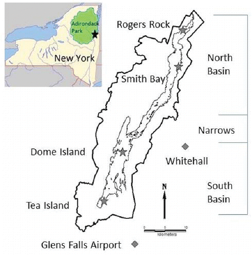
The 4 deep-water sites analyzed for water temperature changes include Tea Island and Dome Island in the South Basin, and Rogers Rock and Smith Bay in the North Basin (). Tea Island (43°26′0′′N; 73°41′29′′W) is the southernmost sampling location with a maximum depth of 31 m. Dome Island (43°32′20′′N; 73°38′08′′W) is located in the South Basin, north of Tea Island, with a maximum depth of 21 m. Smith Bay (43°43′20′′N; 73°28′11′′W) and Rogers Rock (43°48′03′′N; 73°27′26′′W) are both located in the North Basin with maximum depths of 26 m.
Methods
Lake thermal regime
Temperature profiles were collected throughout the length of Lake George from April to November beginning in 1980 as part of an offshore chemical monitoring program (Eichler et al. Citation2010). Profile measurements began in mid/late-April, ∼2 weeks after ice-out, at 2-week intervals until thermocline establishment in mid-June. Monthly sampling was conducted during the summer with 2-week interval sampling resuming in October (Eichler et al. Citation2010). The increased sampling frequency during the establishment and destabilization of the thermocline allowed a finer temporal resolution during these dynamic periods of temperature change.
Temperature measurements were taken at fixed depths of 0, 1, 2, 5, 10, 15, and 20 m, with additional measurements taken at depths with dynamic vertical change. Temperature was recorded with a Yellow Springs Instruments temperature probe, various models (YSI, Yellow Springs, OH). Probes were routinely checked against National Institute of Standards and Technology (NIST) thermometers to verify measurement accuracy. The thermocline normally established in mid-June at ∼10 m and subsequently deepened until turnover in late October/early November.
Average water temperature was calculated for the North and South basins for depth intervals 0–10 m and 11–20 m. Two depth intervals were chosen because the thermocline initially established at ∼10 m, therefore the 0–10 m water temperatures were not influenced by thermocline establishment. The 11–20 m depth interval was included because it represents ∼30% of the water volume in each basin. The top 20 m of the water column account for ∼70% of the water volume in the entire lake (Boylen and Kuliopulos Citation1981). Temperature was calculated for individual days at 1 m resolution between 1 May and 31 October by linear interpolation vertically within the water column and between profile dates, similar to work conducted by Arhonditsis et al. (Citation2004). Daily values were averaged to obtain monthly means utilized in the trend analysis. Mean basin water temperature was an average of the daily water temperature in each basin between 1 May and 31 October. Water temperatures presented for the North Basin are the average of Rogers Rock and Smith Bay while the South Basin water temperatures are the average of Tea Island and Dome Island. Temperature profile data for 1994 were missing and therefore not included in the analyses.
In addition to water temperature, growing season and degree-days were assessed in each basin. The growing season was defined as the number of days the water temperature (0–10 m) was ≥15 C. The date the water temperature reached 15 C in the spring and fall was determined for each year to assess changes in the onset, duration, and end of the growing season between 1980 and 2009. To better assess the duration and magnitude of the warming in the 0–10 m depth interval, degree-days were calculated between 1 May and 31 October as the sum of the daily water temperature difference from 15 C (eq. 1). In this regard, earlier warming, later cooling, and higher summer water temperatures influence the measurement, making it more representative of the thermal change than simply temperature or duration of growing season alone.
(1)
The length of ice cover on Lake George was defined as the duration of time one could traverse the length of the lake without crossing open-water. In years with incomplete ice cover, most of the lake froze with the deepest portions remaining open. The 2 deepest locations in the North and South basins were typically the last areas to freeze completely; both had maximum depths approaching 60 m. Typically the South Basin area froze slightly earlier than the North Basin, presumably due to the larger immediate volume and slightly warmer water temperature in the North Basin. While ice cover is believed to be an important factor affecting water temperature, it could not be incorporated into the analysis because there was no metric, such as fractional ice cover, to utilize in years with incomplete ice cover.
Discharge data from Northwest Bay Brook (USGS 04278300) were used to represent stream discharge into the lake. Northwest Bay is the largest sub-watershed of Lake George encompassing ∼76 km2 (15% of land area) and is primarily forested (Shuster Citation1994). Data utilized were a combination of historical data collected by the United States Geological Survey (USGS 2008) and data collected by Darrin Fresh Water Institute (DFWI). Daily discharge prior to 30 September 1997 was obtained from USGS (USGS 2013). Average daily discharge after 30 September 1997 was calculated from the 15-minute data recorded using a Telog pressure transducer. Traditional stream gauging was conducted using a Brinkman electromagnetic flow meter with measurements taken at 40% of total depth at 1-foot (0.3 m) increments across the width of the stream to establish a discharge rating curve (Gordon et al. Citation1992).
Climate
Two long-term weather stations were located near Lake George at Glens Falls Airport (NOAA-KGFL) and Whitehall (National Weather Service-KNYWHITE7; ). Air temperature data presented are an average of the 2 stations; monthly temperatures at the in-basin atmospheric deposition station (Cedar Lane) were significantly different from individual weather station data (Mar 1992–Dec 2008; t-test, P < 0.01). Glens Falls Airport air temperature was slightly below and Whitehall air temperature was slightly above Cedar Lane air temperature; the average of the 2 stations was not significantly different (t-test, P = 0.881) from Cedar Lane and is presented and utilized in the analyses. Records of cloud cover, humidity, wind, and precipitation were only available from the Glens Falls Airport NOAA station. Cloud cover was based on a 0–8 scale, with 0 representing clear skies and 8 being complete cloud cover. All weather data were reported as daily averages. Glens Falls Airport records were missing for 2000 and therefore were not included in the analyses.
Statistical analysis
Trend analysis was conducted on water temperature and weather data using the USGS Computer Program for the Kendall Family of Trend Tests (Helsel et al. Citation2005). The seasonal Kendall trend test utilized is a Mann-Kendall trend test on the monthly values, which are then combined to provide an overall Kendall tau. The values reported are the correlation coefficient (Kendall τ), the Kendall test statistic (S), the standard normal deviation determined from S and its variance (z), and the significance of the trend (P).
Linear regression on monthly water temperature data over time was conducted in SPSS. Individual monthly temperatures between 1980 and 2009 were normally distributed, but normality failed when using all monthly data between 1980 and 2009. Segmented linear regressions computed with SegReg were used to identify breakpoints that provided significant additional explanation of the data compared to straightforward linear regression (Oosterbaan Citation2009). Analyses were run omitting missing data for weather variables (2000) and water variables (1994). To ensure that breakpoints were not artifacts of missing data, the missing weather variables during 2000 were estimated based on measurements at the National Weather Service station in Albany, New York (∼68 km south). The monthly measurements for each variable were compared between 2000 and 1999/2001; the relative difference between 2000 and the pre- and post-years were used to estimate the missing 2000 data for the Glens Falls Airport data. Utilizing the estimated data showed the same breakpoints as omitting them from the analysis, providing additional assurance that omitting missing data did not bias the analysis.
Table 1 Seasonal Kendall trend analysis of monthly temperature data for the North and South basins at both the 0–10 m and 11–20 m depth intervals from 1980 to 2009. Significant warming trends detected in the top 10 m of the South Basin and the top 20 m in the North Basin. No breakpoints detected. Sample size (N), seasonal Kendall's tau correlation (sK tau), Kendall test statistic (S), standard normal deviate (Z), significance (p) and temperature trend (C/yr) are listed.
Table 2 Linear regressions of monthly water temperature (0–10 m) in the North Basin (NB) and South Basin (SB) from 1980 to 2009.
Kendall tau correlations were run to identify possible explanatory variables that changed in relation to the onset of the growing season or degree-days. Explanatory variables for the onset of the growing season included monthly variables (Nov–Jun) for weather and discharge along with the water temperature (0–10 m) on 31 October of the previous year. By including the water temperature at the end of the monitoring period and then monthly data until the onset of the growing season, variables that would possibly impact the onset of the growing season were included. Similarly, explanatory variables for degree-days included monthly variables (May–Oct) for weather and discharge along with the 1 May water temperature.
Results
Lake thermal regime
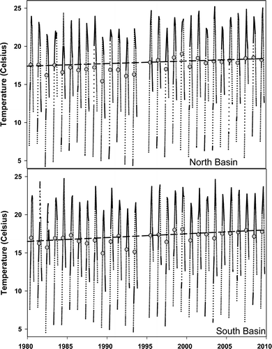
Water temperature (0–10 m) in Lake George significantly increased between 1980 and 2009, with a more pronounced effect in the North Basin. Trend analysis (seasonal Kendall) of monthly water temperature (0–10 m) indicated significant warming in the North and South basins at rates of 0.063 and 0.051 C/yr, respectively (, ). The warming rate was attenuated between 11 and 20 m and was only significant for the North Basin. Individual monthly water temperatures (0–10 m) in the North Basin increased significantly in all months except October, while the South Basin water temperature only increased significantly in June, July, and September (). The greatest warming rate in the North Basin occurred during August, with rates between June and September ≥0.065 C/yr; rates this high only occurred in the South Basin during June and July. The South Basin warming rate in August was similar to May and October, 0.035–0.039 C/yr.
Annual warming patterns were slightly different between basins. The South Basin water temperature was normally warmer during initial sampling, with water temperature in the North Basin warming faster and surpassing the South Basin; water temperature in the North Basin remained warmer throughout the sampling period (). During the 1980s and 1990s, maximum water temperatures were similar between basins, with consistently greater maximum temperatures in the North Basin during the 2000s.
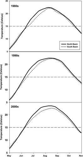
Water temperature increases began earlier in the year, extending the growing season in both basins between 1980 and 2009 with a breakpoint after 1993. The growing season was generally longer in the North Basin, with onset occurring a few days before the South Basin and lasting a few days later in the fall (). The North Basin breakpoint after 1993 equally lengthened the growing season in both the spring and fall, extending the growing season by 14 days (). The South Basin exhibited a breakpoint during the fall and a linear trend during spring, resulting in a 10-day advancement of the growing season over the 30 years. Overall, the South Basin growing season extended ∼12 days comparing the average length of the growing season between pre- and post-breakpoints.
Assessing both duration and magnitude of the water temperature increases with degree-days showed that the North Basin exceeded the South Basin in all but 2 years and exhibited a breakpoint in both basins after 1993. Annual degree-days were significantly (t-test, P = 0.011) greater in the North Basin than the South Basin. Degree-days increased significantly both in linear trends and comparing pre- and post-breakpoint. Linear regressions of annual degree-days (data normally distributed) showed significant trends of 10.8 and 9.2 degree-days/yr in the North (P < 0.001) and South (P = 0.003) basins, respectively; however, comparing pre- and post-breakpoint (t-test) explained more of the variance than linear regressions, with significant increases from 329 to 561 (71%) in the North Basin (P < 0.001) and from 239 to 434 (82%) in the South Basin (P < 0.001, ).
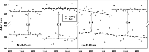
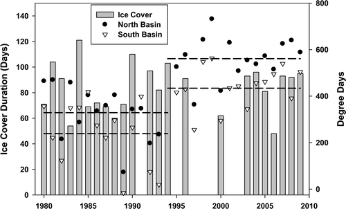
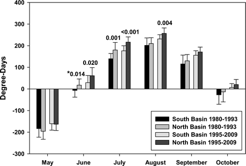
Table 3 Average (standard deviation) monthly degree-days in the North and South basins comparing 1980–1993 to 1995–2009. Significant differences were detected during all months in the North Basin and in all months except May in the South Basin based on t-test. Asterisk indicates data were non-normal and comparison conducted using Mann-Whitney Rank Sum, median values reported.
Analyzing degree-days by month showed significant increases in both basins when comparing pre- and post-breakpoint. All monthly increases were significant in the North Basin, while all months except May were significant in the South Basin (). Examining the difference between basins before and after the breakpoint showed that between 1980 and 1993 degree-days in June and July were significantly different between basins, with significant differences extending into August between 1995 and 2009 ().
The highest number of degree-days in a single season occurred in 1999, with additional high years in 1998 and 2001 that coincided with several years of incomplete ice cover. Between 1995 and 2003, 6 of the 8 years did not have complete ice cover, with only one other year (1991) documented in the 30 years of monitoring. The ice cover records for Lake George agreed well with Lake Champlain. With the exception of 2001, any year Lake George exhibited incomplete ice cover, Lake Champlain also had incomplete ice cover (NWS 2015).
Climate
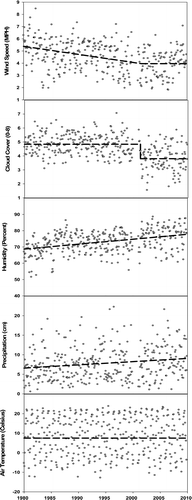
Trend analysis (seasonal Kendall) indicated that wind and cloud cover have significantly decreased, humidity and precipitation have significantly increased, and temperature has not changed significantly between 1980 and 2009 (, ). Wind speed and cloud cover exhibited decreasing trends that were significantly enhanced by breakpoints in 2001; no significant breakpoints were detected for humidity or precipitation. Because mean air temperature showed no significant change, both maximum and minimum air temperatures were additionally analyzed with no significant changes detected in either measurement.
Climate-lake thermal regime relationships
Monthly variables significantly correlated with the onset of the growing season in the North and South basins included wind speed, cloud cover, and stream discharge (). The onset of the growing season was positively correlated to wind speed and cloud cover and negatively correlated to stream discharge. Humidity in the North Basin and air temperature and precipitation in the South Basin were also significantly correlated to the onset of the growing season in their respective basins. The water temperature at the end of the monitoring period (31 Oct) was not correlated to the onset of the growing season in the following year.
Degree-days in both basins were significantly correlated to wind, cloud cover, and 1 May water temperature (0–10 m, ). Degree-days were negatively correlated to wind and cloud cover and positively correlated to 1 May water temperature. In the North Basin, humidity was positively correlated to degree-days.
Discussion
Lake George water temperature has clearly increased between 1980 and 2009, leading to a longer growing season and increased degree-days. The warming effect is more evident in the North Basin than the South Basin. We focus on how the increase in water temperature relates to other lakes, possible explanations for why the thermal regime differs between basins, why the effects of warming are more evident in the North Basin, possible mechanisms responsible for warming of the lake, and, finally, changes and management implications associated with warmer water temperatures.
Lake thermal regime
Water temperature (0–10 m) has increased at a rate of 0.063 and 0.051 C/yr in the North and South basins of Lake George, respectively. These rates are within the range reported for lake warming in the region and throughout the world. Since 1985 inland lake surface water temperatures of large lakes (>500 km2) around the world have increased between 0.018 to 0.13 C/yr; lakes with significant warming trends exhibited a rate of 0.065 ± 0.011 C/yr (Schneider and Hook Citation2010). Regionally, the Great Lakes have experienced increases in surface water temperatures ranging from 0.01 C/yr in Lake Erie to 0.11 C/yr in Lake Superior between 1979 and 2006 (Austin and Colman 2007, 2008). Lake Champlain, which receives Lake George discharge, has increased surface water temperatures in August as much as 3.8 C since 1964 (LCBP 2012). Much of lake warming data originates as surface water temperatures because the data are collected using surface buoys or satellite imagery.
In Lake Washington, which has a similar surface area, volume, and depth to Lake George, warming rates were calculated for the 0–10 m depth and the whole lake. A depth interval of 0–10 m was chosen for their study, as it was in ours, because the thermocline normally developed at or below 10 m. Both lakes had water temperatures >15 C from June to October. Between 1964 and 1998 the warming rates were 0.045 and 0.026 C/yr in the 0–10 m depth and whole lake, respectively (Arhonditsis et al. Citation2004). The rates were slightly less in the epilimnion of Lake Washington compared to Lake George, but that may be due to the shifted sampling period. Lake Washington analysis ended in 1998 when Lake George was experiencing incomplete ice cover and exceptionally high annual degree-days.
Within Lake George, the annual thermal regime differed slightly between the North and South basins, with the North Basin slightly warmer than the South Basin at the end of the monitoring period each year but cooler the following spring. The difference in thermal regime between basins and the more pronounced warming effect in the North Basin may partially be explained by a greater input of groundwater to the South Basin. The south end of Lake George has a larger proportion of sand compared to the rest of the watershed. The quantity of sand diminishes moving north, with the northern end of the lake characterized by finer clay sediments with reduced hydraulic conductivity (McLelland and Isachsen 1986, from Shuster Citation1994). Water temperature in major streams oriented around the south end of the lake exhibit attenuated temperature extremes, with winter temperatures consistently warmer (1–5 C) and summer temperatures consistently cooler (2–4 C) compared to other major streams (Swinton MW, DFWI, unpublished). The transition from warmer to cooler temperatures in the spring and vice versa in the fall occurred within a few degrees of groundwater temperature for the region, ∼8.3 C (USEPA 2013).
A larger input of groundwater would also help explain the more pronounced effects of warming in the North Basin. As meteorological conditions change and enhance thermal absorption and retention in lakes, the warming effect of groundwater will be attenuated. The hydrologic budget of Lake George attributes ∼18% to groundwater inputs directly to the lake (Shuster et al. Citation1994), and with greater hydrologic conductivity in the South Basin, more groundwater is expected to enter the South Basin. This would help explain the lower annual warming rate and lack of significant temperature increases in various months, including August.
Climate
Numerous studies on long-term lake warming indicate increased air temperature as a significant factor leading to increased water temperature; therefore, the lack of a significant change to the minimum, mean, or maximum air temperature in the Lake George region was unexpected but not uncommon for the region. Stager et al. (Citation2009) documented a lack of significant warming throughout the Adirondacks between 1927 and 2005. They proposed that the lack of a significant trend reflected the region's unique climatic condition, which has been documented as one of the most variable in the country, presumably due to the topography, lake effect from the Great Lakes, and a dynamic jet stream (Thaler Citation2006).
Table 4 Seasonal Kendall trend analysis on monthly averages indicates weather variables except temperature have trends significantly different from zero between 1980 and 2009. Sample size (N), seasonal Kendall's tau correlation (sK tau), Kendall test statistic (S), standard normal deviate (Z) and significance (p) are listed.
Table 5 Kendall tau correlations are reported for explanatory monthly variables that significantly correlated to the onset of the growing season in the North and South basins. Monthly (Nov–Jun) weather variables and discharge along with the water temperature at the end of the monitoring period in the previous year were included in the analysis.
Table 6 Kendall tau correlations are reported for explanatory monthly variables that significantly correlated to degree-days in the North and South basins. Monthly (May–Oct) weather variables and discharge along with the water temperature on 1 May in each basin were included in the analysis.
Climate-lake thermal regime relationships
To identify possible mechanisms for the advancement of the growing season and increased degree-days, correlations were conducted using possible explanatory variables. For the purpose of this analysis, an explanatory variable must correlate to the onset of the growing season or degree-days in both basins for it to be considered an influencing variable. Otherwise, the correlations can be considered to be local or an artifact of the sample size or correlations between explanatory variables. The onset of the growing season was correlated to wind, cloud cover, and stream discharge in both basins. The positive correlation between wind and the onset of the growing season during the fall and winter suggest that the decreased wind speed may result in greater thermal retention due to reduced evaporative cooling. Evaporative cooling requires large temperature differences between the water and air, low humidity, and high wind. Conditions during late fall and early winter result in the highest evaporative cooling rates of the year, and reduction in wind would lead to greater thermal retention in the lake. This phenomenon has been documented on Lake Superior as a driving force for water temperature and ice formation (Lenters et al. Citation2013, Spence et al. Citation2013).
The positive correlation between onset of the growing season and cloud cover in May is more straightforward with fewer clouds documented, allowing a greater absorption of solar radiation, the dominant factor influencing warming. Ice-out normally occurred in early/mid-April, and thus May cloud cover would be important in the initial warming of the lake. The lack of any significant relationship between the onset of the growing season and water temperature at the end of October of the previous year implies that conditions occurring in the 6 months between the end of one sampling season and beginning of another overshadow the influence of water temperature at the end of the previous monitoring period. The negative relationship between onset of the growing season and January discharge is likely not a cause and effect relationship but rather an artifact of 2 factors being influenced by a change in climate. Initially, it was thought that the increased January discharge resulted in decreased snowpack and thus decreased spring snowmelt. The diminished spring input, which is near 0 C, would result in warmer water temperatures, but there was no relationship between January and spring discharge as individual months (Mar, Apr, May) or combined. Therefore, it is more likely that both factors were simply influenced by a changing climate, and discharge is not directly influencing water temperature.
Degree-days seem similarly influenced by cloud cover and wind along with the water temperature on 1 May. Cloud cover was negatively correlated to degree-days in both basins throughout the sampling period, implying that less cloud cover results in warmer water temperatures due to enhanced absorption of solar radiation. The positive relationship to 1 May water temperature is also a direct relationship, with warmer water at the start of the sampling period resulting in a greater number of degree-days during a given year.
The negative correlation between degree-days and early summer wind may be a result of a deeper surface mixed layer. Prior to the establishment of the thermocline, higher wind speed results in a deeper surface mixed layer. Once the thermocline establishes, the surface mixed layer continues to mix vertically; therefore, the larger volume would require more energy to increase water temperature compared to a shallower surface mixed layer. Because degree-days were only calculated for the 0–10 m depth interval, the same amount of energy absorption would result in a greater number of degree-days with a shallow mixed layer compared to a deeper surface mixed layer. If this is the case, early summer winds may not result in warmer water temperatures but may simply be an artifact of the measurement.
Impact to lake managers
Warmer water temperatures facilitating a longer growing season and increased degree-days raise concerns for lake managers. Warmer temperatures enhance primary production, which can lead to greater phytoplankton and macrophyte biomass. If primary production becomes too great, additional management effort may become necessary. Additionally, cyanobacteria possess a competitive advantage over other phytoplankton in water temperatures >25 C (Jöhnk et al. Citation2008, Paerl and Huisman Citation2008). Cyanobacteria produce nuisance blooms that can inhibit recreational lake use and toxic blooms that can prohibit all lake use.
At the top of the food web, warmer water temperatures have shifted fish dominance toward eurythermal species in European lakes (Jeppesen et al. Citation2012). With a warming rate of 0.15–0.3 C/yr a profound change in fish assemblages and size has been documented. Additional shifts in community structure, life history traits, body size, feeding mode, and survival are all expected to affect fish communities under warmer conditions (Jeppesen et al. Citation2010). While changes within a single trophic level are well established, interactions between trophic levels are more difficult to identify. In Lake Washington, warming has advanced the spring diatom bloom but not Daphnia, creating an offset between predator and prey interactions and creating a clear disconnect between trophic levels (Winder and Schindler Citation2004).
An initially overlooked area of study associated with climate change is the potential to increase mineralization rates of organic carbon in lakes, which increases dissolved organic carbon (DOC) in surface water. When DOC concentrations increase, the water browns in color, altering macrophyte establishment and phytoplankton biomass (Carpenter et al. Citation1998) while enhancing the absorption of solar radiation (Roulet and Moore Citation2006). Applying the likely warming scenarios (1.8–4 C) for the end of the 21st century predicted by the IPCC, carbon production from lakes could increase by 6.4 Tg/yr (Gudasz et al. Citation2010) creating a positive feedback loop similar to that found in northern peatlands (Dorrepaal et al. Citation2009). Lakes are often overlooked when considering their impact on climate change; however, lakes account for ∼42 Tg/yr of organic carbon burial while only accounting for ∼0.5% of the Earth's surface compared to the ∼97 Tg/yr buried in oceans that account for ∼71% of the Earth's surface (Dean and Gorham Citation1998).
The observed water temperature increase in Lake George is likely already affecting temperature dependent factors, such as primary production and organic carbon mineralization. With maximum summer temperatures near 25 C, a shift to cyanobacteria dominance may be occurring and is the focus of current research on Lake George. Whether the temperature increase has impacted individual species or their interactions is unclear because biotic data collection has been sparse and each project is designed to answer different questions, so the lack of continuity prevents any valid comparisons. Understanding the threats to our water resources in a changing climate is paramount to minimizing the deleterious effects and should be at the forethought of lake managers.
Acknowledgments
The dedicated role of our many contributors has been essential to the progress we have made in understanding Lake George. The authors would like to acknowledge the time and effort of the peer reviewers whose comments and suggestions resulted in a more clear and concise manuscript.
Funding
The DFWI Offshore Chemical Monitoring Program has been jointly funded by Rensselaer Polytechnic Institute and The FUND for Lake George. DFWI is grateful for the steadfast support of the David M. & Margaret A. Darrin and United Parcel Service endowments.
References
- Arhonditsis GB, Brett MT, DeGasperi CL, Schindler DE. 2004. Effects of climatic variability on the thermal properties of Lake Washington. Limnol Oceanogr. 49(1):256–270.
- Austin JA, Colman SM. 2007. Lake Superior summer water temperatures are increasing more rapidly than regional air temperatures: a positive ice-albedo feedback. Geophys Res Lett. 34:L06604.
- Austin JA, Colman SM. 2008. A century of temperature variability in Lake Superior. Limnol Oceanogr. 53(6):2724–2730.
- Boylen CW, Kuliopulos A. 1981. Further studies on the bathymetry of Lake George. In: Boylen CW, editor. . The Lake George Association, Lake George (NY). pp. 47–52.
- Carpenter SR, Cole JJ, Kitchell JF, Pace ML. 1998. Impact of dissolved organic carbon, phosphorus, and grazing on phytoplankton biomass and production in experimental lakes. Limnol Oceanogr. 43(1):73–80.
- Dean WE, Gorham E. 1998. Magnitude and significance of carbon burial in lakes, reservoirs, and peatlands. Geology. 26(6):535–538.
- Dokulil MT, Jagsch A, George GD, Anneville O, Jankowski T, Wahl B, Lenhart, B, Blenckner T, Teubner K. 2006. Twenty years of spatially coherent deepwater warming in lakes across Europe related to the North Atlantic Oscillation. Limnol Oceanogr. 51(6):2787–2793.
- Dorrepaal E, Toet S, van Logtestijn RSP, Swart E, van de Weg MJ, Callaghan TV, Aerts R. 2009. Carbon respiration from subsurface peat accelerated by climate warming in the subartic. Nature. 460:616–619.
- Eichler LW, Ahrens-Franklin L, Boylen CW. 2010. Report on the Lake George Offshore Chemical Monitoring Program 2009. Bolton Landing (NY): Darrin Fresh Water Institute. DFWI technical report #2010-02.
- Frumhoff PC, McCarthy JJ, Melillo JM, Moser SC, Wuebbles DJ. 2007. Confronting climate change in the U.S. Northeast: science, impacts, and solutions. Synthesis report of the Northeast Climate Impacts Assessment (NECIA) Cambridge (MA): Union of Concerned Scientists (UCS).
- Gordon ND, McMahon TA, Finlayson BL. 1992. Stream hydrology: an introduction for ecologists. West Sussex (UK): John Wiley & Sons.
- Gudasz C, Bastviken D, Steger K, Premke K, Sobek S, Tranvik LJ. 2010. Temperature-controlled organic carbon mineralization in lake sediments. Nature. 466:478–481.
- Hayhoe K, Wake CP, Huntington TG, Luo L, Schwartz MD, Sheffield J, Wood E, Anderson B, Bradbury J, DeGaetano A, et al. 2006. Past and future changes in climate and hydrological indicators in the U.S. Northeast. Clim Dynam. 28(4):381–407.
- Helsel DR, Mueller DK, Slack JR. 2005. Computer program for the Kendall Family of trend tests; [cited 6 Feb 2015]. Available from: pubs.usgs.gov/sir/2005/5275/
- [IPCC] Intergovernmental Panel on Climate Change. 2014. Climate Change 2014: synthesis report; [cited 12 Feb 2015]. Available from: http://ipcc.ch/report/ar5/syr
- Jankowski T, Livingstone D, Bührer H, Forster R, Niederhauser P. 2006. Consequences of the 2003 European heat wave for lake temperature profiles, thermal stability, and hypolimnetic oxygen depletion: implications for a warmer world. Limnol Oceanogr. 51(2):815–819.
- Jeppesen E, Meerhoff M, Holmgren K, González-Bergonzoni I, Teixeira-de Mello F, Declerck SAJ, De Meester L, Søndergaard M, Lauridsen TL, Bjerring R, et al. 2010. Impacts of climate warming on lake fish community structure and potential effects on ecosystem function. Hydrobiologia. 646:73–90.
- Jeppesen E, Mehner T, Winfield IJ, Kangur K, Sarvala J, Gerdeaux D, Rask M, Malmquist HJ, Holmgren K, Volta P, et al. 2012. Impacts of climate warming on the long-term dynamics of key fish species in 24 European lakes. Hydrobiologia. 694:1–39.
- Jöhnk KD, Huisman J, Sharples J, Sommeijer B, Visser PM, Stroom JM. 2008. Summer heatwaves promote blooms of harmful cyanobacteria. Glob Change Biol. 14:495–512.
- King JR, Shuter BJ, Zimmerman AP. 1997. The response of the thermal stratification of South Bay (Lake Huron) to climatic variability. Can J Fish Aquat Sci. 54:1873–1882.
- [LCBP] Lake Champlain Basin Program. 2012. State of the lake and ecosystem indicators report 2012; [cited 10 March 2015]. Available from: http://sol.lcbp.org/index.html#.VQwoFeFBnnd
- Lenters JD, Anderton JB, Blanken P, Spence C, Suyker AE. 2013. Assessing the impacts of climate variability and change on Great Lakes evaporation. In: Brown D, Bidwell D, Briley L, editor. 2011 project reports. Available from: http://glisaclimate.org/media/GLISA_Lake_Evaporation.pdf
- Livingstone DM. 2003. Impact of secular climate change on the thermal structure of a large temperate central European lake. Clim Change. 57:205–225.
- Luterbacher J, Dietrich D, Xoplaki E, Grosjean M, Wanner H. 2004. European seasonal and annual temperature variability, trends and extremes since 1500. Science. 303:1499–1503.
- Mishra V, Cherkauer KA, Bowling LC. 2011. Changing thermal dynamics of lakes in the Great Lakes region: role of ice cover feedbacks. Global Planet Change. 75:155–172.
- [NWS] National Weather Service. 2015. Date of Lake Champlain closing; [cited 4 March 2015]. Available from: http://weather.gov/btv/lakeclose
- Oosterbaan RJ. 2009. SegReg: segmented linear regression with breakpoint and confidence intervals; [cited 17 Feb 2015]. Available from: http://waterlog.info/segreg.htm
- Paerl HW, Huisman J. 2008. Blooms like it hot. Science. 320:57–58.
- Roulet N, Moore TR. 2006. Browning the waters. Nature. 444:283–284.
- Schneider P, Hook SJ. 2010. Space observations of inland water bodies show rapid surface warming since 1985. Geophys Res Lett. 37:L22405.
- Shuster EL. 1994. Hydrogeology of the Lake George drainage basin, southeastern Adirondack Mountains, New York. [dissertation]. [Troy (NY)]: Rensselaer Polytechnic Institute.
- Shuster EL, LaFleur RG, Boylen CW. 1994. The hydrologic budget of Lake George, southeastern Adirondack Mountains of New York. Northeast Geol. 16(2):94–108.
- Spence C, Blanken PD, Lenters JD, Hedstrom N. 2013. The importance of spring and autumn atmospheric conditions for evaporation regime of Lake Superior. J Hydrometeorol. 14:1647–1658.
- Stager JC, McNulty S, Beier C Chiarenzelli. 2009. Historical patterns and effects of changes in Adirondack climates since the early 20th century. Adirondack J Envir Stud. 15(2):22–38.
- Stager JC, Thill M. 2010. Climate change in the Champlain Basin. The Nature Conservancy.
- Stainsby EA, Winter JG, Jarjanazi H, Paterson AM, Evans DO, Young JD. 2011. Changes in the thermal stability of Lake Simcoe from 1980 to 2008. J Great Lakes Res. 34:55–62.
- Thaler JS. 2006. Adirondack weather: history and climate guide. Yorktown Heights (NY): Hudson Valley Climate Service.
- [USEPA] US Environmental Protection Agency. 2013. Average temperature of shallow groundwater; [cited 26 May 2014]. Available from: http://www.epa.gov/athens/learn2model/part-two/onsite/ex/jne_henrys_map.html.
- [USGS] National Water Information System. 2008. Northwest Bay Brook; [cited 15 Jan 2009]. Available from: http://nwis.waterdata.usgs.gov/nwis/inventory/?site_no=04278300&agency_cd=USGS&
- [USGS] National Water Information System. 2013. Lake George at Rogers Rock NY; [cited 16 Apr 2013]. Available from: http://nwis.waterdata.usgs.gov/nwis/uv/?site_no=04278000&agen-cy_cd=USGS&referred_module=sw
- Winder M, Schindler DE. 2004. Climate change uncouples trophic interactions in an aquatic ecosystem. Ecology. 85(8):2100–2106.