
ABSTRACT
Anderson JP, Paterson AM, Reavie ED, Edlund MB, Rühland, KM. 2017. An introduction to Lake of the Woods – from science to governance in an international water body. Lake Reserv Manage. 33:325–334.
Lake of the Woods (LOW), a vast lake covering over 3850 km2, is a waterbody of current and historical significance that spans the borders between Minnesota and the Canadian provinces of Ontario and Manitoba. Over the past 2 decades, there has been concern for the water quality of LOW, sparked by anecdotal evidence of increased intensity and frequency of algal blooms by the public and resource managers. Minnesota's waters of LOW were declared impaired in 2008 due to exceedances of eutrophication criteria, initiating a Total Maximum Daily Load study. LOW's impairment declaration spurred several contrasting challenges and opportunities for water quality management across this diverse lake and basin. Governance challenges are emphasized by the large number of government agencies (>25) with land or water authorities in the 70,000 km2 basin, the variability in phosphorus standards applicable to LOW between Minnesota, Ontario, and Manitoba, and unequal funding resources allocated to LOW's water quality management agencies. Despite these challenges, there is a long history of international cooperation among agencies, recent funding increases, and the formation of a new International Joint Commission Board with the mandate to monitor ecosystem health in the entire LOW basin. As highlighted by the studies in this issue, the science of nutrient and algal dynamics in LOW is complex, and water quality restoration may take years to decades because major sources of nutrients to the lake are not subject to reductions by conventional lake restoration methods. An overview of papers in this special issue is provided.
KEYWORDS:
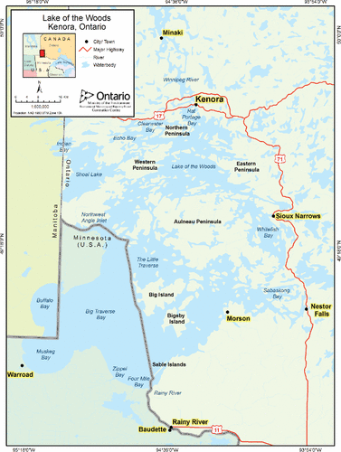
Lake of the Woods (LOW), a morphologically and hydrologically complex large lake covering over 3850 km2, is a waterbody of current and historical significance that spans the borders between Minnesota and the Canadian provinces of Ontario and Manitoba (). LOW provides the drinking water supply for more than 750,000 people, including the city of Winnipeg, Manitoba, and is a premier summer cottage, fishing, and tourism destination with annual economic impact worth tens of millions of dollars. The lake is composed of several distinct basins with varying water quality characteristics (see reviews in Clark and Sellers Citation2014, DeSellas et al. Citation2009). In general, the southern basin is shallow, relatively uniform in depth, has a predominately well-mixed water column due to a large fetch, and is mesotrophic to eutrophic. In contrast, the northern portion, characterized by exposed Precambrian Shield bedrock, is more heterogeneous in nature with numerous bays and thousands of islands, and is deeper and generally less productive (Pla et al. Citation2005). Hydroelectric dams at the lake's outlet in Kenora, Ontario, have controlled lake elevations since the late 1800s.
Figure 1. Lake of the Woods (from DeSellas et al. Citation2009).
The International Joint Commission (IJC), a US and Canadian transboundary organization that regulates shared water uses, investigates transboundary issues and recommends solutions (IJC Citation2015), regulates lake levels and outflows in LOW and other large upstream lakes. The Rainy River, LOW's primary tributary, enters the lake from the southeast () and has a median annual flow of 288 m3 per second (USGS Citation2013). The Rainy River contributes about 70% of the lake's inflow (Kallemeyn et al. Citation2003) and 75% of the external phosphorus load (Hargan et al. Citation2011). From approximately 1910 to the late 1970s, the River experienced severe impacts by discharge from industrial pulp and paper and domestic sewage facilities (IJC Citation1918, Citation1965, Citation1970). However, the Rainy River is currently a high-quality water, due to mandated improvements in wastewater treatment, exemplified by the recovery of its lake sturgeon (Acipenser fulvescens) population (Heinrich and Friday Citation2014).
LOW drains a very large watershed of nearly 70,000 km2, a landscape dominated by boreal forest, wetlands, and lakes (Olmanson and Bauer Citation2017), including the Boundary Waters Canoe Area Wilderness, Voyageur's National Park (Minnesota), and Quetico Provincial Park (Ontario). The area was a main waterway of the fur trade era from the early 18th to the mid-19th centuries (Nute Citation1941, Morse Citation1969, Lund Citation1975). The region's vast timber resources drove permanent settlement of the area starting in the late 19th century (Drache Citation1983, Citation1992); timber harvesting and the forest products industry currently remain fundamental sectors of the economy. Agricultural land use, principally pastureland, makes up about 2% of the basin, and is concentrated along the lower portions of the Rainy River and the southern shore of LOW (Olmanson and Bauer Citation2017).
LOW is challenging to monitor due to its vast size, large fetch, frequent high winds, navigational hazards, hydrologic complexity, and cross-border regulations. Therefore, water quality sampling has often been a cooperative effort between many groups, including the Minnesota Pollution Control Agency (MPCA), Minnesota Department of Natural Resources, Lake of the Woods County Soil and Water Conservation District, US Geological Survey, the Red Lake Band of Chippewa Indians, First Nations, Ontario Ministry of Natural Resources and Forestry, Ontario Ministry of the Environment and Climate Change (OMECC), Environment and Climate Change Canada (ECCC), and citizen volunteers. Over the past 2 decades, there has been concern for the water quality of LOW, sparked by anecdotal evidence of increased intensity and frequency of algal blooms by both the public and resource managers, and an increase in media reports on nuisance blooms that included one dog death (http://www.mprnews.org/story/2016/05/24/water-toxic-algae-dogs-climate-change). Remote sensing research documenting bloom aerial extent supports these concerns (Binding et al. Citation2011, Heiskary et al. Citation2006).
The MPCA led a water quality sampling program in 1999, 2005, and 2006 and declared the Minnesota portion of LOW as impaired for recreational use in 2008, due to exceedances of eutrophication criteria (Heiskary and Wilson Citation2008). In 2009, a Total Maximum Daily Load (TMDL) study was initiated, bringing further attention to the water quality of LOW. The MPCA's TMDL study, scheduled for completion in 2018, will identify water quality goals for the Minnesota portion of LOW, recommend nutrient allocations and reductions to achieve the TMDL goals, and provide opportunities for stakeholders to engage in the broader watershed management plan, encompassing both protection and restoration practices (https://www.pca.state.mn.us/sites/default/files/wq-iw1-54.pdf).
Challenges to water quality management in the Lake of the Woods basin
LOW's impairment declaration spurred a productive period for monitoring and science activities in the basin. However, several challenges must be overcome if management activities are to be effective moving forward. Some of these challenges are discussed below.
Governance
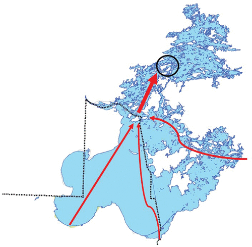
There are more than 25 government agencies and organizations with land and water authorities in the LOW basin (IJC Citation2015), with jurisdictions including federal, state, provincial, tribal, Metis, First Nations, county (United States only), and municipal. The regulation and implementation of Minnesota's Impaired Waters (i.e., TMDL) study applies to the Minnesota waters of LOW only; there are no parallel programs in Ontario or Manitoba. This presents challenges for setting water quality goals in this international lake for 2 fundamental reasons: (1) water flow in LOW is complex and crosses jurisdictional boundaries, controlled by wind-driven circulation and river flow (Zhang et al. Citation2013), but principally flows north from Minnesota's more eutrophic waters toward more dilute Canadian waters (); (2) no single total phosphorus (P) objective is prudent for LOW with its basins ranging in trophic status from oligotrophic to eutrophic (Pla et al. Citation2005, DeSellas et al. Citation2009, Hyatt et al. Citation2011, Clark and Sellers Citation2014, Environment Canada Citation2014). Although MPCA's authorities technically end at the international border, the TMDL's realistic water quality management endpoint is the outlet of Little Traverse Bay, adjacent to Minnesota's Northwest Angle peninsula, a natural constriction of water flow that integrates conditions in all US and Canadian basins to the south, central, and east (). Via the TMDL's technical advisory and civic engagement committees, the MPCA has shared and vetted key communication messages regarding TMDL governance and implementation to partner agencies, organizations, and the public.
Figure 2. Generalized water flow paths in the southern and central basins of Lake of the Woods. Dotted black line is international border, circle is hydrologic outlet of southern basins in the Big Narrows vicinity.
Funding for water quality management
Financial resources are not allocated equally among water quality management agencies within the LOW basin. Citizens of Minnesota passed the Clean Water Land and Legacy Amendment in 2008, which increased sales tax revenue to provide about $90 million (US) annually for 25 yr to protect drinking water sources, and to protect, enhance, and restore lakes, rivers, streams, and groundwater (Eshenaur et al. Citation2014). From 2004 to 2016, the State of Minnesota spent over $19 million within the Minnesota waters of the LOW basin on watershed monitoring and modeling, planning, and wastewater infrastructure improvements.
The IJC has recently (2012) formed a new Board, the International Rainy-Lake of the Woods Watershed Board, with the mandate to monitor ecosystem health in the LOW basin. The Board petitioned the development of a Water Quality Plan of Study (IJC Citation2015) to improve understanding of water quality issues in the basin. The Plan of Study includes the following priority issues: nutrient enrichment and harmful algal blooms, aquatic invasive species, surface and groundwater contamination including heavy metals and other contaminants, and crosscutting features of climate change and hydrologic regulation (IJC Citation2015). The Plan of Study is much broader in scope and geography than the MPCA's TMDL study. In 2016, the Canadian government allocated ∼$5.5 million to help fund ongoing research and management efforts within the Rainy-LOW Basin. With binational partners, ECCC is using this funding over 4 yr to prepare and implement their Science Plan for the Rainy River and Lake of the Woods Watershed—an integrated research and monitoring program designed to provide the necessary science to support future binational decisions and actions (Veronique Hiriart-Baer, ECCC, Nov. 2016, pers. comm.). ECCC previously allocated over $18 million on its LOW and Lake Winnipeg Basin Initiatives from 2012 to 2017.
Variation in water quality standards
A fundamental challenge to management in LOW is the variability in P water quality standards across jurisdictions (). Specific to LOW, P standards or objectives vary from 20 µg/L to 30 µg/L between Ontario, Manitoba, and Minnesota, although the water quality goal among governments is analogous—to prevent nuisance algae and protect aquatic life. Only Minnesota has corresponding standards for chlorophyll a (Chl-a) and Secchi transparency to measure a lake's response to elevated P, potentially impairing lake recreational use (Heiskary and Wilson Citation2008). There are no federal P standards or objectives in either the United States or Canada because the regulation of water quality standards is delegated to the states and provinces, although ECCC and the US Environmental Protection Agency provide recommendations and guidance (USEPA Citation2000, Canadian Council of Ministers of the Environment Citation2004).
Table 1. Lake total phosphorus guidelines, standards, or objectives for Manitoba, Ontario, and Minnesota waters of Lake of the Woods.
A history of international cooperation
Despite the many challenges inherent to water quality management of this large international lake, tremendous progress in lake management has occurred in the LOW basin over the past 2 decades.
| • | The work conducted by water quality and natural resource management agencies within the LOW basin has been recognized by the IJC as a successful example of cooperative watershed management. As a result, the International Rainy-Lake of the Woods Watershed Board was selected as one of the first IJC boards with a watershed mandate in 2013. | ||||
| • | In 2009, 4 yr before the establishment of the International Rainy-Lake of the Woods Watershed Board, 9 government organizations signed the International Multi-Agency Working Arrangement. The agreement aims to foster trans-jurisdictional coordination and collaboration on science and management activities that enhance or restore water quality in the LOW watershed between Ontario, Manitoba, Minnesota, the Red Lake Band of Chippewa Indians, and the United States (https://lowwsf.com/our-work). This working agreement is still in effect today. | ||||
| • | In 2012, the International Watershed Coordination program was established by the Lake of the Woods Water Sustainability Foundation in partnership with the IJC and other management agencies. The program's coordinator works to link agencies and communities with science, civic engagement, and resource management across the basin, including promotion of binational involvement in Minnesota's TMDL study and citizen science efforts such as Minnesota's citizen lake and stream monitoring programs and Ontario's Lake Partner program. | ||||
| • | Fisheries in LOW and other upstream international lakes, such as Rainy Lake and the Namakan Reservoir, have been cooperatively managed by the Ontario and Minnesota natural resource departments since the 1980s (Minnesota Department of Natural Resources and Ontario Ministry of Natural Resources Citation2004). | ||||
| • | Since 2004, water quality and resource management research in the LOW basin has been shared annually at the International Rainy-Lake of the Woods Watershed Forum in International Falls, Minnesota. This is an annual face-to-face meeting of more than 100 resource managers, scientists, and other interested parties working on science and management issues within the Rainy-Lake of the Woods basin. | ||||
| • | Several citizen groups and nonprofit organizations have long been active in an advocacy role for water quality and natural resource issues in LOW and its international watershed. These include the Lake of the Woods District Property Owners Association, the Lake of the Woods Water Sustainability Foundation, the Rainy Lake Conservancy, the White Iron Chain of Lakes Association, and the Voyageur's National Park Association. | ||||
Overview of papers in this issue
This special issue starts with Olmanson and Bauer (Citation2017), who describe the methods and results of land cover classification in the Lake of the Woods-Rainy River Basin. They apply a uniform method for the ∼1990 and ∼2010 time periods to assess land cover and associated changes over time, with the results now available for hydrologic modeling. With the finalized maps, they tabulated the area and calculated percent of area by land-use class at the sub-basin and total Lake of the Woods-Rainy River Basin. The Basin is dominated by forest, wetlands, and lakes which comprise 96.3% of the basin. Developed areas increased slightly in the basin from 1.36% in 1990 to 1.41% in 2010.
Next are 2 papers by James describing estimates of internal phosphorus loading in the southern basin of LOW. The first paper (James Citation2017a) describes a set of sediment cores collected in 2011 for determination of sediment textural and chemical characteristics, and rates of diffusive and equilibrium P fluxes from bottom and resuspended sediments in LOW. Sediment total P concentrations were modest, ranging between 0.64 mg/g and 0.76 mg/g. Biologically labile P (subject to recycling and biological uptake) accounted for ∼30–50% of the total P, and iron-bound P represented ∼45–60% of this biologically labile fraction. Diffusive P fluxes from sediment were relatively high under anaerobic conditions (8.3–12.5 mg/m2/day) and coincided with moderately high concentrations of iron-bound P in the sediment. In contrast, aerobic diffusive P fluxes were over 20 times lower (0.2–0.6 mg/m2/day). However, equilibrium P flux during resuspension represents a potential P source for algal uptake and growth and could be significant when ambient soluble reactive P concentrations fall below the equilibrium P concentration. The second paper (James Citation2017b) describes sediment cores from Big Traverse Bay that were incubated at 3 different temperatures, under anaerobic and aerobic conditions, for laboratory determinations of diffusive P flux. James (Citation2017b) developed regression relationships between P flux and temperature to increase accuracy of internal P loading estimates in LOW. Under aerobic conditions, mean diffusive P fluxes varied between 0.05 mg/m2/day (0.01 SE) at 5 C and 0.36 mg/m2/day (0.06 SE) at 25 C. Summer aerobic diffusive P fluxes for Big Traverse Bay sediment were moderate and fell near the median relative to P fluxes measured for other Minnesota lake sediments. Vertical sediment P profiles also suggested that past P accumulation has exceeded diagenesis and burial, resulting in the modest buildup of P that may drive future internal P loading.
Reavie et al. (Citation2017) analyzed sediments from 6 sites to reconstruct the environmental history of LOW's southern basin to quantify the magnitude and direction of historical trophic change, and evaluate reasons for the lake's lack of recovery. They report major changes in the algal community during and following peak nutrient loading in the mid-20th century, and more recent increases in colonial cyanobacteria and diatom taxa with higher nutrient preferences. Fossil indicators reflect an anthropogenically enriched system that has undergone substantial ecological change, particularly since ∼1980, due to multiple drivers including recent climate change. These drivers may be exacerbating internal P release and enhancing cyanobacteria abundance.
Edlund et al. (Citation2017) describe historical phosphorus dynamics and, using a paleolimnological approach, construct a historical P budget for the southern basin of LOW. Sediment cores from 7 bays were dated and analyzed for geochemistry, diatoms, and pigments, and models were used to explore historical P loading scenarios and in-lake nutrient dynamics. Modeling results suggest that water column P was much higher in the past (1950s–1970s) than it is currently. LOW is very sensitive to changes in external load because P losses from burial and outflow are large fluxes. Following nearly a decade of consistent external loading, the lake is rapidly moving to a new steady state with regard to water column P and size of the active P pool; legacy loads may no longer be responsible for current lake conditions. Algal community changes that have occurred after reduction of external P loads are in part counterintuitive and they suggest other drivers including variation in the seasonality of P loading, shifting nutrient limitation, and climate change may be affecting the modern limno-ecology of LOW.
Paterson et al. (Citation2017) explore the importance of total P concentrations and recent climate change (warming and changes in precipitation) on long-term trends in primary production across the northern regions of LOW. They examine spectrally inferred Chl-a from sediment cores retrieved from five impacted sites and one reference site to explore the apparent disconnect between reported increases in cyanobacterial blooms and declines in external nutrient loading in recent decades. The oligotrophic reference site showed no trend in inferred Chl-a over the past ∼100 yr. In contrast, an increase in inferred Chl-a was noted at all impact sites, beginning in the late 1970s. The increases in inferred Chl-a were not significantly correlated to diatom-inferred P concentrations, but were significantly and positively correlated to climatic variables, including mean annual air temperature at all sites and total annual precipitation at 4 sites. Furthermore, these increases in sedimentary Chl-a occurred despite significant reductions in external nutrient loading from the Rainy River since the 1970s, and during a period when measured P concentrations at these LOW sites were stable or in decline. Their data suggest that recent warming may have exacerbated algal blooms through changes in lake physical properties and related changes in water column nutrient cycling or internal P loading.
Watson and Kling (Citation2017) evaluate the phytoplankton and trophic status of LOW, and provide a detailed species listing and the first evaluation of the smaller planktonic size fractions (bacteria, picocyanobacteria, and nanoplankton). The predominant bloom species are nitrogen-fixing cyanobacteria with average total phytoplankton biomass varying spatially and across years, and with the highest biomass recorded in the shallower, more eutrophic southern zones of LOW. The authors note that while P ultimately limits phytoplankton biomass in LOW, community composition may also be influenced by short-term deficiencies in nitrogen and silica. The differing sampling techniques (surface vs. depth integrated samples) used by the various partners to monitor the lake may result in dissimilarities in reported algal species composition and abundance; this finding has important implications for database integration and interpretation of spatial and temporal patterns.
In a pair of papers, Zastepa et al. (Citation2017a and Citation2017b) examine spatial and temporal trends of microcystin (MC) in LOW. The first paper (Zastepa et al. Citation2017a) describes spatial–temporal patterns of particulate and dissolved MC toxins in LOW. MC concentrations measured in offshore whole water samples were consistently low despite high Chl-a levels (e.g., 0.7 µg/L MC-LR equivalents/L at 126 µg/L Chl-a), with only 2 cases exceeding the World Health Organization microcystin guideline for recreational contact (20 µg/L). MC-LR was the dominant congener in LOW with MC-LA present in minor amounts. Compared to offshore sites, shoreline samples contained much higher microcystin concentrations, with 33% and 25% of the samples testing >20 µg/L in 2006 and 2009, respectively (with a peak measure of >600MC-LR equivalents/L). Algal composition and abundance suggested several sources of MC, including several species of Dolichospermum and Microcystis, consistent with other lakes in Canada. The second paper by Zastepa et al. (Citation2017b) measures the flux of MC congeners from LOW sediments, with dated sediment cores used to examine the historical occurrence of MC. MC was found to be below detection limits in sediments prior to the 2000s; the most abundant congeners were MC-LA and MC-LR with a greater diversity of congeners observed in upper core sections. Diffusion from sediments was estimated from the concentration gradient between the pore water of surficial sediments and overlying water using Fick's first law. Overall, burial rates were low across sites (0.1–10.9 ng/cm/yr) when compared to diffusion of MC from sediments to overlying water (11.1–39.3 ng/cm/yr), suggesting sediments may be a source of MC to the water column.
In the final paper of this Special Issue, McDaniel and Pascoe (Citation2017) describe a study on benthic macroinvertebrates as indicators of environmental change in LOW. The goal of the study was to assess areas of potential anthropogenic impact in LOW using a benthic macroinvertebrate reference condition approach, and to identify factors correlated with these impacts. The paper also provides baseline information on sediment chemistry prior to the initiation of increased mining activity in the basin. Concentrations of both nutrients and metals exceeded Ontario provincial and Canadian federal low-effect levels at many sites and, in some cases, probable and severe effect levels for aquatic life. High concentrations of metals and nutrients in sediments were often found in deep sites in the center of basins and were sometimes associated with low dissolved oxygen. The benthic community at both Poplar Bay and Bigstone Bay was found to be highly divergent from reference sites, with substantial reductions in diversity and abundance. Other sites with impacts to the benthic community included Deception Bay, Whitefish Bay, and the central northern basin of the lake. In general, benthic invertebrate diversity appeared to be most affected at sites that were deep, thermally stratified, high in nutrients and metals (such as lead and arsenic), and had low concentrations of dissolved oxygen in the hypolimnion.
Managing Lake of the Woods: Moving forward
As highlighted by the studies in this issue, the science of nutrient and algal dynamics in LOW is complex. Thus, understanding the spatial and temporal context of these parameters will be key when setting water quality and restoration goals for LOW. For example, while P concentrations in Minnesota's LOW waters exceed water quality standards (), the Rainy River, LOW's primary inflowing tributary (Hargan et al. Citation2011), is meeting the MPCA's river eutrophication standards for P and sestonic Chl-a (Heiskary and Bouchard Citation2015). Moreover, recent millennial-scale studies suggest that the lake is naturally, moderately productive (Teller et al. Citation2017). In southern waters, historical accounts of algal blooms were recorded during the fur trade and exploration era, decades before the beginning of European settlement. For example, in July 1823, LOW was described as “foul, frequently covered with a green scum of vegetable matter” (Keating Citation1824, McElroy and Riggs Citation1943), and “always greenish” (Bigsby Citation1850). In August 1857, LOW's southern basin was described as “tinged with green deriving its colour from a minute vegetable growth, until it gave the appearance to the lake of a vast expanse of dirty green mud” (Canada Provincial Secretary's Office Citation1859, Hind Citation1860). New modeling efforts (e.g., Minnesota's TMDL study goals and reduction strategies) must consider these historic trophic state conditions and include a “margin of safety” to account for uncertainty in the relationship between pollutant loads and receiving water quality (USEPA Citation1999).
Paleoecological analysis and modeling results suggest that the lake is sensitive to changes in external nutrient loading, as shown by elevated P concentrations in the mid-20th century in response to higher nutrient flux from municipal and industrial discharges to the Rainy River (Hargan et al. Citation2011, Edlund et al. Citation2017, Reavie et al. Citation2017). Thus, further opportunities for nutrient reductions should be explored, although statistically significant declines in P concentration have already been documented at long-term (>50 yr) monitoring sites on the Rainy River (Minnesota Pollution Control Agency Citation2014), and land-use assessments (e.g., Olmanson and Bauer Citation2017) suggest that much of the watershed is relatively pristine. Importantly, decades of elevated loading have left a legacy load of P in lake sediments, and currently internal loading represents a significant P source to LOW (James Citation2017a, Citation2017b). Given its size, conventional lake restoration methods (e.g., P inactivation or dredging) are unlikely to be effective in LOW. The good news is that the legacy P load from lake sediments is slowly diminishing (Edlund et al. Citation2017) and a new steady-state may soon be reached.
Climate change will likely complicate recovery in LOW, as toxic algal blooms may increase in frequency and severity with warming, and increased water temperatures, thermal stability, and duration of the ice-free season may exacerbate internal P release from lake sediments (James Citation2017b, Paterson et al. Citation2017, Reavie et al. Citation2017). This region of North America has already shown significant increases in air temperature and precipitation since the late 1970s, particularly in the winter and spring months for air temperature. Climate change, and its influence on primary producers and nutrient loading, must be considered in future modeling and management efforts.
As outlined in the State of the Basin Report for the Lake of the Woods and Rainy River Basin (DeSellas et al. Citation2009), significant knowledge gaps on biological condition have existed for LOW, including data on the distribution and composition of algal communities and algal toxins. As severe algal blooms have been identified as a primary concern for local stakeholders, an improved understanding of the factors that control the formation and distribution of toxic algae is needed to develop effective management strategies for LOW. New data on phytoplankton (Watson and Kling Citation2017) and the distribution and flux of algal toxins (Zastepa et al. Citation2017a, Citation2017b) have significantly improved our understanding of algal community structure and function in LOW. Moreover, data on benthic macroinvertebrate communities (McDaniel and Pascoe Citation2017) provide a new tool for assessing changes in lake biota in response to multiple stressors, including metal contamination. These biological studies also provide the baseline data needed to track the effectiveness of future management initiatives, or changes that may occur as new stressors emerge (e.g., mining, climate change).
In closing, management solutions will require the continued cooperation of many groups, including an engaged public, if they are to be effective at a local scale. Successful water quality management in this complex, international basin is incumbent on cooperation, inclusion, and transparency and the history learned over the >100 yr of managing shared waters on the Canada and US border.
Acknowledgments
We thank Todd Sellers, Kelli Saunders, Dan Engstrom, Pam Anderson, Mike Kennedy, Pat Carey, Suzanne Hanson, and Nolan Baratono for ongoing support and suggestions for this manuscript. We also thank 2 anonymous reviewers, who greatly improved this manuscript. The authors of this paper (i.e., the Special Issue's associate editors) express thanks to Editor-in-Chief of Lake and Reservoir Management (LRM), Al Sosiak, and LRM's publisher Taylor & Francis Group, for supporting this Special Issue.
References
- Bigsby JJ. 1850. The shoe and canoe or pictures of travel in the Canadas illustrative of their scenery and of colonial life. London (UK): Chapman and Hall.
- Binding CE, Greenberg TA, Bukata RP. 2011. Time series analysis of algal blooms in Lake of the Woods using the MERIS maximum chlorophyll index. J Plan Res. 33:1847–1852.
- Canada Provincial Secretary's Office. 1859. Papers relative to the exploration of the country between Lake Superior and the Red River settlement. London: George Edward Eyre and William Spottiswood, Her Majesty's Stationary Office. Available from https://babel.hathitrust.org/cgi/pt?id=hvd.32044072259203;view=1up;seq=7
- Canadian Council of Ministers of the Environment. 2004. Canadian water quality guidelines for the protection of aquatic life: phosphorus: Canadian guidance framework for the management of freshwater systems. Winnipeg: Canadian environmental quality guidelines, 2004, Canadian Council of Ministers of the Environment. Available from http://ceqg-rcqe.ccme.ca/download/en/205
- Clark BJ, Sellers TJ, editors. 2014. Rainy-Lake of the Woods state of the basin report. 2nd edition. Available from http://ijc.org/files/publications/R-LOW_SOBR_2014_web-res.compressed.pdf
- DeSellas AM, Paterson AM, Clark BJ, Baratono NG, Sellers TJ. 2009. State of the Basin report for Lake of the Woods and Rainy River Basin. Lake of the Woods Water Sustainability Foundation. Available from https://lowwsf.com/sobr/19-2009-sobr-webres/file
- Drache H. 1983. Koochiching, pioneering along the Rainy River frontier. Danville (IL): Interstate Printers and Publishers.
- Drache H. 1992. Taming the wilderness, the northern border country 1910–1939. Danville (IL): Interstate Printers and Publishers.
- Edlund MB, Schottler SP, Reavie ED, Engstrom DR, Baratono NG, Leavitt PR, Heathcote AJ, Wilson B, Paterson AM. 2017. Historical phosphorus dynamics in Lake of the Woods (USA–Canada) — does legacy phosphorus still affect the southern basin? Lake Reserv Manage. 33:386–402.
- Environment Canada. 2014. Environment Canada's Lake of the Woods science initiative 2008–2011. Available from http://publications.gc.ca/collections/collection_2017/eccc/En164-49-1-2014-eng.pdf
- Eshenaur T, Wagner M, Westerlund J, editors. 2014. Minnesota's clean water roadmap. State of Minnesota. Available from http://www.legacy.leg.mn/sites/default/files/resources/Clean_Water_Report_web2.pdf
- [IJC] International Joint Commission. 1918. Final report of the International Joint Commission on the pollution of Boundary Waters Reference. Available from http://www.ijc.org/files/publications/ID33.pdf
- [IJC] International Joint Commission. 1965. Report of the International Joint Commission on the pollution of Rainy River and Lake of the Woods. Available from http://www.ijc.org/files/dockets/Docket%2073/Docket%2073%20Final%20Report%201965.pdf
- [IJC] International Joint Commission. 1970. Report to the International Joint Commission on the Rainy River water use and water quality. Available from http://www.ijc.org/files/publications/T8.pdf
- [IJC] International Joint Commission. 2015. A water quality plan of study for the Lake of the Woods Basin. Available from http://www.ijc.org/files/publications/LOWPOS_EN_01282015.pdf
- Hargan KE, Paterson AM, Dillon PJ. 2011. A total phosphorus budget for the Lake of the Woods and Rainy River catchment. J Great Lakes Res. 37:753–763.
- Heinrich T, Friday M. 2014. A population assessment of the Lake of the Woods – Rainy River lake sturgeon population. Minnesota Department of Natural Resources and Ontario Ministry of Natural Resources and Forestry. Available from http://www.ijc.org/files/publications/RainyRiver_LakeWoods_SturgeonPop2014.pdf
- Heiskary SA, Wilson CB. 2008. Minnesota's approach to lake nutrient criteria development. Lake Reserv Manage. 24:282–297.
- Heiskary SA, Bouchard RW. 2015. Development of eutrophication criteria for Minnesota streams and rivers using multiple lines of evidence. Freshw Sci. 34:574–592.
- Heiskary S, Olmanson L, Gitelson A, Chipman J. 2006. Remote sensing: does it have a role?. N Am Lake Manag Soc Lakeline. Spring 2006:27–35.
- Hind HY. 1860. Narrative of the Canadian Red River exploring expedition of 1857 and of the Assinniboine and Saskatchewan exploring expedition of 1858. London (UK): Longman, Green, Longman and Roberts. Available from https://catalog.hathitrust.org/Record/008688401
- Hyatt CV, Paterson AM, Rühland KM, Smol JP. 2011. Examining 20th century water quality and ecological changes in the Lake of the Woods, Ontario, Canada: a paleolimnological investigation. J Great Lakes Res. 37:456–469.
- James W. 2017a. Internal phosphorus loading contributions from deposited and resuspended sediment to the Lake of the Woods. Lake Reserv Manage. 33:347–359.
- James W. 2017b. Diffusive phosphorus fluxes in relation to the sediment phosphorus profile in Big Traverse Bay, Lake of the Woods. Lake Reserv Manage. 33:360–368.
- Kallemeyn LW, Holmberg KL, Perry JA, Odde BY. 2003. Aquatic synthesis for Voyageur's National Park. US Geological Survey Information and Technology report 2003–0001. Available from http://www.cerc.usgs.gov/pubs/center/pdfdocs/ITR2003-0001.pdf
- Keating WH. 1824. Narrative of an expedition to the source of St. Peter's River, Lake Winnnepeek, Lake of the Woods, in two volumes. 1823. Philadelphia (PA): H.C. Carey & I. Lea.
- Lund DR. 1975. Lake of the Woods yesterday and today. Staples (MN): Nordell Graphic Communications.
- Manitoba Water Stewardship. 2011. Manitoba water quality standards, objectives, and guidelines. Manitoba Water Stewardship Report 2011–01. Available from https://www.gov.mb.ca/waterstewardship/water_quality/quality/pdf/mb_water_quality_standard_final.pdf
- McDaniel T, Pascoe T. 2017. Applying the reference condition approach to Lake of the Woods: sediment and benthic invertebrate community assessment for lake wide management. Lake Reserv Manage. 33:452–471.
- McElroy R, Riggs T. 1943. The unfortified boundary, a diary of the first survey of the Canadian boundary line from St. Regis to Lake of the Woods by Major Joseph Delafield. New York (NY): privately printed.
- Minnesota Department of Natural Resources and Ontario Ministry of Natural Resources. 2004. Minnesota-Ontario Boundary Waters fisheries atlas for Lake of the Woods, Rainy River, Rainy Lake, Namakan Lake, Sand Point Lake.
- Minnesota Pollution Control Agency. 2014. Water quality trends for Minnesota rivers and streams at Milestone Sites. St. Paul (MN). Available from https://www.pca.state.mn.us/sites/default/files/wq-s1-71.pdf
- Morse EW. 1969. Fur trade canoe routes of Canada/ then and now. Ottawa: Government of Canada. Available from http://parkscanadahistory.com/publications/fur-trade-canoe-routes.pdf
- Nute GL. 1941. The voyageur's highway, Minnesota's border lake land. St. Paul (MN): Minnesota Historical Society.
- Olmanson L, Bauer M. 2017. Land cover classification of the Lake of the Woods/Rainy River Basin by object-based image analysis of Landsat and lidar data. Lake Reserv Manage. 33:335–346.
- Ontario Ministry of the Environment and Energy. 1994. Provincial water quality objects of the Ministry of Environment and Energy. Available from https://dr6j45jk9xcmk.cloudfront.net/documents/3016/moeprovincialwaterqualityobjectivesen.pdf
- Ontario Ministry of the Environment. 2010. Ontario's lakeshore capacity assessment handbook; Appendix A - rationale for a revised phosphorus criterion for Pre-Cambrian shield lakes in Ontario. Toronto (ON). Available from https://dr6j45jk9xcmk.cloudfront.net/documents/1155/87-lakeshore-capacity-assessment-handbook-fr-2.pdf
- Paterson AM, Rühland KM, Anstey CV, Smol JP. 2017. Climate as a driver of increasing algal production in Lake of the Woods, Ontario, Canada. Lake Reserv Manage. 33:404–414.
- Pla S, Paterson AM, Smol JP, Clark BJ, Ingram R. 2005. Spatial variability in water quality and surface sediment diatom assemblages in a complex lake basin: Lake of the Woods, Ontario, Canada. J Great Lakes Res. 31:253–266.
- Reavie E, Edlund M, Andersen N, Engstrom D, Leavitt P, Schottler S, Cai M. 2017. Paleolimnology of the Lake of the Woods southern basin: continued water quality degradation despite lower nutrient influx. Lake Reserv Manage. 33:369–385.
- Teller JT, Rühland KM, Smol JP, Mellors TJ, Paterson AM. 2017. Holocene history of Lake of the Woods: Ontario, Manitoba and Minnesota. GSA Bull. doi:10.1130/B31790.1.
- [USEPA] United States Environmental Protection Agency. 1999. Protocol for development of nutrient TMDLs. first edition. Washington (DC): US EPA report 841-B-99-007. Available from https://nepis.epa.gov/Exe/ZyPDF.cgi/20004PB2.PDF?Dockey=20004PB2.PDF
- [USEPA] United States Environmental Protection Agency. 2000. Nutrient criteria technical guidance manual. Washington (DC): US EPA Report EPA-822-B000-001. Available from https://www.epa.gov/nutrient-policy-data/criteria-development-guidance-lakes-and-reservoirs
- [USGS] United States Geological Survey. 2013. Annual data report for Rainy River at Manitou Rapids. Available from http://wdr.water.usgs.gov/wy2013/pdfs/05133500.2013.pdf
- Watson SB, Kling H. 2017. Lake of the Woods phyto- and picoplankton: spatiotemporal patterns in blooms, community composition, and nutrient status. Lake Reserv Manage. 33:415–432.
- Zastepa A, Watson S, Kling H, Kotak B. 2017a. Spatial and temporal patterns in microcystin toxins in Lake of the Woods surface waters. Lake Reserv Manage. 33:434–443.
- Zastepa A, Pick F, Blais J. 2017b. Distribution and flux of microcystin congeners in lake sediments. Lake Reserv Manage. 33:444–451.
- Zhang W, Watson S, Rao Y, Kling H. 2013. A linked hydrodynamic, water quality and algal biomass model for a large, multi-basin lake: a working management tool. Ecol Model. 269:37–50.
