Abstract
Landfill fugitive methane emissions were quantified as a function of climate type and cover type at 20 landfills using U.S. Environmental Protection Agency (EPA) Other Test Method (OTM)-10 vertical radial plume mapping (VRPM) with tunable diode lasers (TDLs). The VRPM data were initially collected as g CH4/sec emission rates and subsequently converted to g CH4/m2/day rates using two recently published approaches. The first was based upon field tracer releases of methane or acetylene and multiple linear regression analysis (MLRM). The second was a virtual computer model that was based upon the Industrial Source Complex (ISC3) and Pasquill plume stability class models (PSCMs). Calculated emission results in g CH4/m2/day for each measured VRPM with the two approaches agreed well (r 2 = 0.93). The VRPM data were obtained from the working face, temporary soil, intermediate soil, and final soil or synthetic covers. The data show that methane emissions to the atmosphere are a function of climate and cover type. Humid subtropical climates exhibited the highest emissions for all cover types at 207, 127, 102, and 32 g CH4/m2/day, for working face (no cover), temporary, intermediate, and final cover, respectively. Humid continental warm summers showed 67, 51, and 27 g CH4/m2/day for temporary, intermediate, and final covers. Humid continental cool summers were 135, 40, and 26 g CH4/m2/day for the working face, intermediate, and final covers. Mediterranean climates were examined for intermediate and final covers only and found to be 11 and 6 g CH4/m2/day, respectively, whereas semiarid climates showed 85, 11, 3.7, and 2.7 g CH4/m2/day for working face, temporary, intermediate, and final covers. A closed, synthetically capped landfill covered with soil and vegetation with a gas collection system in a humid continental warm summer climate gave mostly background methane readings and average emission rates of only 0.09 g CH4/m2/day flux when measurable.
The OTM-10 method is being proposed by EPA to quantify surface methane emissions from landfill covers. This study of 20 landfills across the United States was done to determine the efficacy of using OTM-10 for this purpose. Two recently published models were used to evaluate the methane flux results found with VRPM optical remote sensing. The results should provide a sense of the practicality of the method, its limitations at landfills, and the impact of climate upon the cover's methane flux. Measured field data may assist landfill owners in refining previously modeled methane emission factor default values.
Introduction
Landfills become anaerobic within months of the placement of municipal waste. This is due to the rapid depletion of oxygen by aerobic bacteria. This is followed by the development of anaerobic bacteria that predominate from that point forward. Landfill gas, generated by the biological degradation of waste by anaerobic bacteria, is a mixture of 50% carbon dioxide and 50% methane. Each of these gases is greenhouse a gas. However, methane is of great concern due to its higher global warming potential (GWP) and is believed to have 23 times the GWP of carbon dioxide (CitationIntergovernmental Panel on Climate Change, 2001). The amount of methane emitted from landfills to the atmosphere is controlled by the type of cover on the landfill and the effectiveness of the gas collection system. Emitters of potent greenhouse gases, such as methane, will need to make reasonable estimates of their effect on atmospheric burdens with the advent of mandatory greenhouse gas reporting in the United States. For sanitary landfills, a methane mass balance is the best way to completely constrain such estimates, and requires accurate measurement of the landfill gas collected, the methane oxidized by the landfill cover soils, and the methane lost as emissions (CitationSpokas et al., 2006). The sum of these measurements is essentially equivalent to the total methane produced by the landfill (CitationSpokas et al., 2006), then the landfill's gas collection efficiency can be calculated as the methane collected divided by the methane produced (CitationBarlaz et al., 2009; CitationBogner and Spokas, 1993; CitationSpokas et al., 2006). Overall, landfill carbon should ultimately be accounted for as collected, oxidized, emitted, or sequestered. This study only addresses the measurement of methane emissions from landfill covers.
A variety of methods, such as dynamic and static mobile plume monitoring, inverse plume modeling, differential adsorption LiDAR (light detection and ranging), and radial plume mapping, exist to estimate the emissions of methane from the landfill surface (CitationBabilotte et al., 2008). However, none of these methods has been sufficiently field tested to resolve uncertainties and develop best implementation practices. An accurate and cost-effective method of determining landfill gas emissions must be proven and adopted to support regulatory programs. This study afforded an opportunity for the scientific community, working in collaboration with landfill operators and the U.S. Environmental Protection Agency (EPA), to evaluate the vertical radial plume mapping technique (VRPM) as described by EPA OTM-10 (Other Test Method-10) (EPA, 2006) for its efficacy in the quantification of methane emissions from various landfill cover types and environments.
Optical remote sensing employing a tunable diode laser (TDL) was used to estimate the methane flux from the landfill surface by VRPM (CitationHashmonay and Yost, 1999; CitationU.S. Environmental Protection Agency, 2006, Citation2007) at 20 landfills across the United States during a 4-year effort (2006–2009). The EPA OTM-10 was originally developed to determine the mass of gas that crosses a VRPM plane of lasers that is located downwind from the emissions source on a flat surface (CitationU.S. Environmental Protection Agency, 2006). The concentration measurements are combined with local wind speed and wind direction data to derive the flux (mass per time) across the vertical measurement plane. The flux data are then used to estimate the gas emission rate from the upwind source. Typically, the area contributing to the measured flux is smaller than the length of the VRPM measuring plane, for example, a hog-waste lagoon (CitationShores et al., 2005). In this case, the area contributing to the emissions passing through the VRPM plane can be clearly identified. In contrast, landfills are significantly larger than the VRPM plane measuring the source. The size of the area (m2) contributing to the emissions quantified in the VRPM g/sec flux measurement is not clearly defined. Using this method to measure landfill emissions represents a change from the original technique.
To express the methane flux as a mass flux per unit surface area per unit time (g/m2/day), a technique was needed to generate the upwind surface footprint that was captured by the VRPM plane that intercepted the surface emissions plume. Two models have been been published that estimate the area contributing to flux (ACF). The multiple linear regression method (CitationThoma et al., 2010) (MLRM) presents one equation for flat surface ACF determination and a second equation for the ACF determination of a flat surface followed by a sloped surface (flat surface upwind of the VRPM with a sloped surface further upwind and both contributing). The MLRM method is based upon the release of methane and acetylene in the field at measured distances and angles from the VRPM plane and the measured capture efficiency of the released gases by the VRPM plane. The ISC3-PSCM (Industrial Source Complex Dispersion Model and Pasquill Stability Class Model)/U.S. EPA OTM-10 virtual method (CitationAbichou et al., 2010; U.S. Environmental Protection Agency, 1995) is the second. This model will be referred to as PSCM. The PSCM method is a virtual computer model that simulates area source methane emissions and capture by the VRPM plane. Both models were used to calculate the ACF for use with collected flux data as g methane/sec to allow conversion to g methane/m2/day.
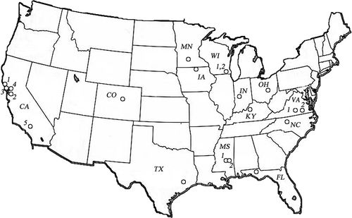
Final soil covers, intermediate soil covers, temporary soil covers, working face (no cover), and synthetic covers were studied during this research with the goal of providing information to allow method evaluation and quantification of methane emissions for studied cover types. Intermediate and final soil covers were the predominant cover type studied, as these offered the best chance to make measurements at an active landfill without interfering with operations and comprised the majority of the cover at the landfills studied. These studies included predominantly flat landfill tops. The study locations are shown in and specific site and climate information are given in (The Weather Channel).
Table 1. Categorization of landfill study sites for methane emissions
Figure 1. Optical remote sensing study locations across the United States. The sites spanned climate types ranging from semiarid in the western USA to humid subtropical in the southern USA.
Once field tested and adopted with implementation guidance, an accurate and reliable measurement technique can be used to evaluate methane emissions from landfills. It would be advantageous to the landfill owner to use actual methane emission measurements as opposed to emission factors based upon modeling techniques such as those found in AP 42 (EPA, 1998). AP 42 is a EPA document that provides emission factors for air pollutants. The area source emission factors for landfill methane found in this document are based upon modeled assumptions. Sound field measurements can augment or refine these fugitive methane emission factors. For example, EPA protocols define the amount of methane recovered by the gas collection system as 75% of the methane produced within most landfills (CitationU.S. Environmental Protection Agency, 1998). Methane emitted to the atmosphere is defined as 22.5% of the LandGEM (U.S. Environmental Protection Agency, 2005)(Landfill Gas Emissions Model)–produced quantity, and oxidized methane as 2.5% (10% of the emitted value). Recent literature indicates that the 75% value is an underestimate of methane capture efficiency in many cases and well-managed landfills currently perform better than the guidelines suggest (CitationSpokas et al., 2006). Moreover, the oxidation capacity of the soil used in landfill covers has been found to be much greater than 10% (CitationAbichou et al., 2006; CitationAbichou et al., 2006; CitationChanton et al., 2009; CitationChanton et al., 2010).
Materials and Methods
Optical remote sensing using vertical radial plume mapping (VRPM)
The EPA OTM-10 optical remote sensing (ORS) approach was used to capture methane concentration within a wind intercepting VRPM plane. The VRPM ORS method was evaluated during this study. A TDL was used as the ORS, since methane absorbs strongly in the infrared portion of the electromagnetic spectrum. The basic OTM-10 VRPM setup is shown in with a hypothetical ACF footprint. The configuration was arranged in the field as shown in Two lasers defined four VRPM planes to intercept the wind through the study area. Plane length ranged from 75 to 300 m. The landfills studied were considerably larger than the areas defined by these planes. Upwind of the planes were large flat areas followed by sloped areas. It should also be noted that the four-plane configuration of OTM-10 is a revision of the described method to minimize the movement of equipment to capture the methane plume during changing wind directions. The OTM-10 method describes the use of only one VRPM setup.
Figure 2. Schematic of the OTM-10 setup with an expected ACF from a perpendicular wind to the VRPM plane. Percentages represent the simulated methane surface emissions recovery with distance (11).
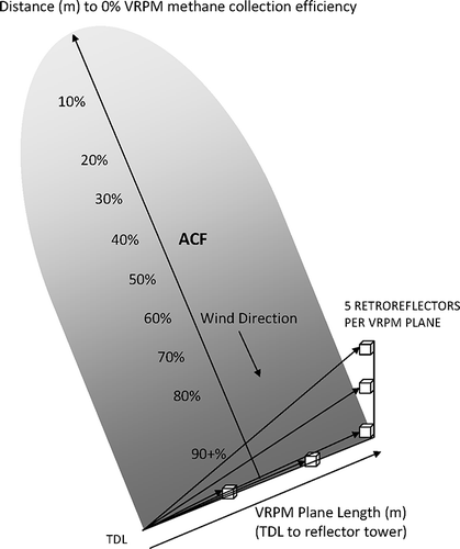
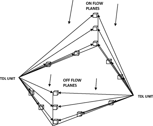
Figure 3. VRPM measurement layout for most study sites. Each side of the box is referred to as a “leg.” Multiplane setup allows efficient collection of data.
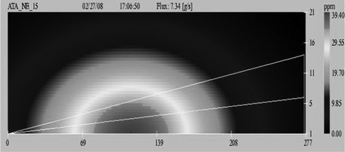
Each VRPM plane for this study was a five-beam configuration as depicted in The results were calculated by ARCADIS software (CitationARCADIS U.S., Inc., 2007) from the OTM-10 equations. Briefly, the OTM-10 VRPM method uses a computational algorithm. This algorithm utilizes a two-phase smooth basis function minimization (SBFM) for plume reconstruction where a one-dimensional SBFM reconstruction procedure is applied to reconstruct the smoothed ground level and crosswind concentration profile. The reconstructed parameters are substituted into the bivariate Gaussian function before applying the two-dimensional SBFM procedure. The VRPM procedure calculates the concentration values for each square elementary unit in a vertical plane. These values are integrated and incorporated with wind speed data at each height to compute the flux. Concentration values in ppmv are converted to g/m3 considering the molecular weight of the gas being tested. An anemometer determined wind direction and velocity at 2 and 12–15 m above the surface. The software integrates the values, incorporating wind speed data at each height level to calculate flux in g/sec through the VRPM plane to generate a time-averaged plot, as shown in
Figure 4. Example of a VRPM concentration gradient map. The x-axis represents the cross wind distance (TDL to tower in meters). Note that the concentration decreases with height. TDL located on lower left.
Each laser in scanned two legs (10 reflectors). Three reflectors were placed along a surface transect from the laser to the lift at 1/3 and 2/3 and total distance. The total distance reflector on the ground was placed at the base of the lift, the fourth at the vertical midpoint of the lift and the fifth at the top of the lift. The laser dwell time for each retro-reflector was 30 sec and with laser movement between dwell points resulted in a total run time per scan of approximately 4 min. Each computer-recorded result was the moving average of three complete VRPM plane scans. The majority of the measurements utilized four VRPM planes so that the methane swept from the study area surface (ACF) was generally intercepted regardless of the wind direction. This offers the best-case scenario for efficient data collection in a relatively short amount of time without moving the setup to intercept the wind, as would be the case with a single plane approach. Typically, two legs of the four will be receiving wind from outside the rectangle and referred to as on-flow. Two more legs will be receiving wind from inside and outside the rectangle and referred to as off-flow (). With on-flow and off-flow winds, there is the opportunity to have eight data sets during a measurement session. There is some distance and surface area upwind that is contributing methane that passes through the measuring plane(s). It was often the case that some of these legs collected more data than other legs. One of the purposes of this study is to examine ways of combining the data from these individual segments.
The four-plane approach was utilized at the majority of the landfills studied due to shifting winds throughout the day and this provided the most efficient approach for data collection, since no repositioning of the equipment was necessary with this method. Only two planes were necessary for five of the landfills studied, since the prevailing winds were from one direction. The layout of VRPM test areas began with the examination of contour maps of the landfill followed by visual surveillance to determine appropriateness. The area to be evaluated with this technique requires open continuous lines of sight to allow the lasers to reflect back to themselves from the reflectors to collect the data. Major field method restrictions are irregular surfaces, precipitation, fog, operating wind speed from 1 to 8 m/sec, and that the wind angle should not exceed 60° from perpendicular to the intercepting VRPM plane. Final processed data produce a VRPM output as shown in with the concentration gradient going from a higher concentration at the surface to a lower concentration at the top. The flux in g/sec is calculated as previously described by the ARCADIS Flux Calculator (CitationARCADIS U.S., Inc., 2007) software for each VRPM plane over time and averaged to produce the final daily result per leg (plane).
Two significant problems with applying OTM-10 to landfills exist. First, rough and/or irregular topography contribute to unusual wind currents, which often result in unusable data due to plume mixing and is given as a method restriction (CitationBabilotte et al., 2008). Secondly, a method for properly defining the upwind surface area contributing to the flux (CitationGoldsmith et al., 2008) for landfills had not been addressed until recently. As previously stated, this is an issue that is particularly important for the application of this technique to landfills, as they are larger than the flux-area captured by the VRPM plane. The precise area (m2) captured by the VRPM plane is a parameter that must be defined. That is, a result of g/sec produced by VRPM methodology must at some point be assigned a contributing surface weighted upwind distance and/or VRPM plane capture efficiency to obtain a result of g/m2/day of methane emissions. This will allow an assignment of flux values for each type of landfill cover and ultimately an estimate of total surface emissions.
Recent work (CitationAbichou et al., 2010; CitationThoma et al., 2010) allowed for some analysis and resolution of this problem, as discussed next.
Area contributing to flux (ACF) calculations
The discussed limitations of OTM-10 for landfills resulted in the development of a method for estimating the surface area of the landfill contributing to the amount of methane measured in the downwind VRPM plume. The multiple linear regression method (CitationThoma et al., 2010) is based upon controlled releases of methane and acetylene tracer gases in an area with no known interfering emissions. The measurement of these tracer gases released at multiple distances and wind angles from the VRPM plane determined how much of the original released gas is collected (measured). All, a portion, or none of the original tracer gas plume may be measured at certain distances and angles from the VRPM plane. The plume may pass completely over the plane or some or all of the plume may be carried beyond the bounds of the VRPM path length. The VRPM collection efficiency data were based upon an analysis of 1161 data points from 48 releases and the model is a multiple linear regression fit of VRPM collection efficiency data, the wind-adjusted release distance (WARD) from the measurement plane, and wind speed. A collection efficiency factor (CEF) of zero suggests that none of the released emissions were measured by the VRPM plane. The model authors believed that a distance where the methane mass capture=0% (no released emissions pass through VRPM plane) would underestimate the emissions per unit area. They defined the calculation of area contributing to the flux (ACF) as the product of the VRPM plane length (laser to reflector tower) and one-half the wind adjusted release distance at which the collection efficiency factor is equal to zero as determined by the multiple linear regression model Equationeq 1(1) for a flat surface.
where CEF is the normalized VRPM plane collection efficiency factor, WARD (m) is the distance from the release point to the VRPM plane divided by the cosine of the wind angle measured from a vector perpendicular to the VRPM plane, and WS is the wind speed (m/sec). The coefficients in the CEF equation were based upon the tracer gas release data generated for a flat landfill surface. The tracer gas data resulted in a figure where wind speed is related to the distance at which there would be 0% recovery of emissions. For example, at 2 and 7 m/sec wind speed, the model predicts a distance to zero point emissions recovery of 295 and 460 m, respectively. For a laser length of 150 m, the associated ACF would be 22,125 m2 at 2 m/sec (150 × 295/2) and 34,500 m2 at 7 m/sec (150 × 460/2).
Tracer gas releases were also made from slopes beyond flat areas and the mathematical evaluation by multiple linear regression was performed on the VRPM capture. A flat surface followed by a sloped surface would be described as follows (Equationeq 2(2)) and making note that the paper describes the field data for slopes as not sufficient for a standalone analysis.
The CEF equations were then used, based upon the tracer gas release results, to predict the upwind distance and width of the surface that was contributing methane to the VRPM plane measuring the methane molecules emitted from the surface. At each site all the required data were collected for wind angle, speed, etc., for model application. The g/sec VRPM flux results were divided by the modeled ACF footprint in m2 to generate results in g CH4/m2/day. Note that the MLRM method does not account for a step function fall off in capture efficiency with distance from the VRPM plane to the point where at distance CE=0%.
The second method of estimating the ACF is a virtual computer model and was developed from the ISC3 and Pasquill Stability Class Model (CitationAbichou et al., 2010). The paper provides an approximation of the area contributing to the flux (ACF) for application to the VRPM measurements made in landfill applications. The method mimics the same measurement processes that occur in the field. The simulations are based on plume dispersion analysis combined with a virtual VRPM analysis that reproduced the same mass flux estimation scheme described in OTM-10. The ISC3 model was used to generate a virtual reality of a dispersing plume caused by a continuous release on a flat surface (CitationU.S. Environmental Protection Agency, 1995). ISC3 is a popular steady-state Gaussian plume model that has been used to assess pollutant concentrations from a wide variety of sources associated with industrial atmospheric emissions. This model can estimate pollutant concentrations at any point in space, C(x, y, z), from point, area, line, and volume sources based on atmospheric conditions and mass flux of pollutant from the source itself. For a point source, the Gaussian plume model as shown below in Equationeq 3(3), the concentration at a point C(x, y, z) is as follows:
where x is the downwind distance, y is the cross-wind distance, z is the height (m), u is wind speed (m/sec), Q is the mass flux at the source, and σ y(x) and σ z(x) are the horizontal half-width of the plume (m). The ISC3 model obtains the functions σ y(x) and σ z(x) according to the Pasquill atmospheric stability class and whether the plume spreading is in rural or urban conditions. The plume parameters σ y and σ z are driven by atmospheric turbulence and are influenced by the state of convection in the atmosphere. The Pasquill Stability Class (A–F) is based upon atmospheric conditions of wind speed and solar radiation (cloud cover, darkness) and when combined with the ISC3 assists in predicting plume shape.
With the exception of the ISC3 modeling, the steps follow the OTM-10 procedure for generating a VRPM flux (concentration gradient from ground to 21 m). In this regard, extended source simulations, small point simulations, and small point sources embedded in extended source simulations were evaluated to assess the uncertainty of the VRPM technique. This model can assign a percentage of methane capture for each emission at distance from the VRPM plane. Emissions near the VRPM plane will be effectively captured (90+%). The percentage of capture falls with distance to 0% as shown in and the ACF is the integration of this weighted area. Large uncertainties were reported associated with the OTM-10 method due to the mixing of the individual plumes before they cross the VRPM plane (CitationAbichou et al., 2010). The best-case scenarios were considered to have an uncertainty of 10–30% depending upon the plume stability class at the time of measurement. Higher uncertainties are expected under field conditions.
In summary, the MLRM was based upon controlled releases of known amounts of tracer gases (methane and acetylene) in the field. The PSCM was based upon the ISC3-Pasquill modeled simulation of the landfill surface, with the contributing area being weighted with distance from the VRPM receptor plane and subsequent estimation of the amount of the plume captured. Just as with the MLRM method, g/sec VRPM flux results were divided by the ACF footprint estimate in m2 to generate flux results in g CH4/m2/day.
Finally, an important measurement for either method is the distance to the waste boundary from the VRPM plane. If the ACF distance is beyond the filled waste area, then this area should not be counted as contributing surface area in the calculations. As such, these corrections were meticulously made for each site as necessary.
Results and Discussion
The survey of landfill surface emissions was performed to determine the quantity of fugitive methane emission from landfill surfaces under various climatic conditions, cover conditions, and cover types. Many variables may impact the flux result, including current methane production rate, effectiveness of gas collection, cover maintenance and the presence of methane emissions from outside the study area. This investigation provided an analysis of method efficacy across these various parameters. Landfills with intermediate and final covers had operating landfill gas collection systems. Temporary, daily, or working face covers were not under gas collection.
During the course of the study, 72,581 scans were made and 49,819 of those did not meet the required qualifying VRPM criteria for a valid result, as previously described. This gave a VRPM scan acceptance rate of 31.4%. Two approaches to handling the data were evaluated.
Methods comparison
In the MLRM method, the overall CEF (VRPM capture efficiency factor) was lower for slopes than for flat surfaces. Methane emissions on a flat surface were found to be more efficiently captured (CitationThoma et al., 2010). Emissions far from the VRPM plane or from slopes were only partially captured or not at all as there is a decreasing probability of the plume passing through the VRPM plane and below the maximum integration height. Both the flat surface equation and flat surface followed by a slope equation were evaluated. This method of determining the ACF tended to yield smaller ACF areas (m2) than the virtual PSCM (CitationAbichou et al., 2010).
Two methods of examining the collected data were compared. These were based upon 1) VRPM leg results, i.e., finding the mean of the scans for each leg and then averaging the mean leg results and 2) taking the average of all VRPM scans collected for all legs at a site (combining all of the measurements and weighting each one equally), which is referred to as data binning.
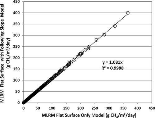
VRPM legs. Let us consider Four VRPM planes or legs of the rectangle are available to collect wind from the landfill surface in several directions as long as the method qualifying criteria for acceptance are met. As noted previously, many conditions make a VRPM scan result unacceptable. The number of acceptable scans per leg may vary from as few as 10 to as many as 200 or more, for example. In this approach, each leg result was an average of the scan data collected by each leg daily regardless of the number of data points. This would give equal weight to a leg with 20 daily data points and one with 200 daily data points. A comparison of 547 individual leg daily averages across 20 landfills and various cover types for the ACF formulas used is shown in The comparison of the two MLRM model equations for generating an ACF and resulting flux demonstrates that the inclusion of the coefficients for sloped surfaces in the CEF equation causes the flux result to be 8% higher. This is simply because this equation generates a smaller ACF footprint due to poor collection efficiency by the VRPM leg receiving wind from sloped surfaces. The correlation between the two model equations is strong (r 2 = 0.99), as would be expected, as they are based upon the same data for the flat portion tracer gas CEF data, with the difference being the inclusion of the CEF data collected from sloped tracer gas releases upwind of a flat surface (CitationThoma et al., 2010).
Figure 5. Comparison of the flux calculated from MLRM flat surface equation ACF to the flux calculated from the MLRM flat surface followed by a sloped surface equation ACF for all daily VRPM plane results.
Alternatively, campaign results for legs, that is, the representative result for a site over a 2–5-day period, were the average of all individual leg daily results. First, individual daily VRPM leg results (say there were four legs, two with five viable scans and two with 150 viable scans) were averaged with equal weight given to each. For example, the four legs would give average flux results of 35 (5 scans) + 52 (5 scans) + 60 (150 scans) + 28 (150 scans) = 175/4 = 43.75 g CH4/m2/day for the VRPM leg daily average. All the daily averages were then combined to give a campaign average. The advantage to looking at individual leg averages is that it allows the investigator to determine if some unusual condition associated with a particular portion of the cover is influencing the result.
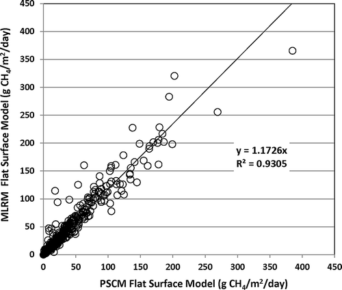
A comparison of the MLRM flat surface model to the ISC3-PSCM flat model for generating the ACF is shown in The PSCM flat model yields flux results that are 17% lower than the MLRM flat surface model. The PSCM flat model indicated that the VRPM plane was able to detect sources from more than twice the upwind distance as the MLRM flat surface model under certain stability class situations, for example on cloudy days. This model then generates a larger contributing ACF footprint and, therefore, a smaller flux result on a per square meter basis (flux result in g/sec divided by the model generated ACF (m2) to arrive at g CH4/m2/day). It is important to know that the OTM-10 approach does not include stability class estimation and this is a significant consideration for large area source applications. The ISC3-PSCM model paper (CitationThoma et al., 2010) utilizes the ability of a virtual computer program that allows for the creation of source releases of several strengths and distances under all atmospheric stability classes.
Figure 6. Comparison of the flux calculated by the MLRM flat surface model ACF to the flux calculated by the PSCM flat surface model ACF for daily VRPM plane results.
Data binning. The second method of data analysis is referred to as binning. All accepted VRPM scans from all VRPM legs (planes) at a site and specific cover type were “binned” together and averaged to get a representative flux. In other words, consider two VRPM planes that may have had five qualifying scans each. Another two VRPM planes at the site may have had 150 qualifying results each. The binned approach averaged the 310 scans (5 + 5 + 150 + 150 scans) for a daily result for that cover type. A campaign average for a cover type would simply combine all the scans made for each day on site for a single campaign average result.
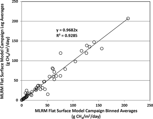
The MLRM flat surface model was used to calculate the ACF and resultant flux for the following comparisons of daily leg averages to daily binned averages. shows that the comparison of the two methods for daily averages compare well (r 2 = 0.95) and differ by just over 1%. Further examination was done using the same approach except that all the VRPM leg results for a week long campaign at one site and cover type were averaged and compared to campaign binned scan averages, as shown in Once again the techniques for campaigns gave comparable results (r 2 = 0.92) with the binned scan results being 3.2% higher than the leg averages. This suggests that the leg averaging method slightly reduces the result. These data indicate that the simplest approach is to let a VRPM plane or planes operate over a period of time and bin the results for a representative flux. The binned campaign results for all site visits with observations (n) and standard errors are given in
Table 2. Binned flux (g CH4/m2/day) results by campaign and cover types of working face, temporary soil, intermediate soil, final soil, and final synthetic
Figure 7. Comparison of daily VRPM plane daily leg averages to daily binned scan averages for the MLRM flat surface model calculation as g CH4/m2/day flux.
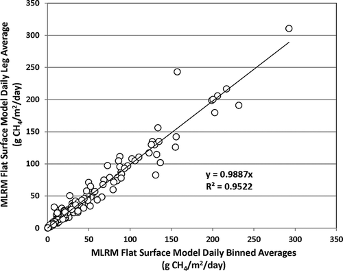
Figure 8. Comparison of campaign VRPM leg averages to campaign (3–5 days) binned averages using the MLRM flat surface model equation to calculate ACF to determine g CH4/m2/day flux.
Landfill methane emissions
The results from across the United States are presented as binned scan campaign averages (generally 3–5 days of data collection per cover type per site visit) using the MLRM flat surface model to generate the ACF and resultant flux for comparative purposes. The cover types presented are the working face (no cover), temporary soil cover (15–30 cm), intermediate soil cover (0.6–1.2 m), final soil cover (1–2 m), and one example of a synthetic geomembrane with an overlying soil cover at a landfill with gas collection. It was observed early in the research that there were differences in flux measurements for different parts of the United States. Additionally, as a result of previous landfill bioreactor studies (CitationReinhart and Townsend, 1998), the researchers were aware of the impact of moisture content on gas production. Examination of the results demonstrated trends in the fugitive methane emissions between various climatic areas. Although not all landfills use the same soil type, soil thickness and operating practices for their cover, some inferences can still be made to characterize the performance of different landfill covers and the methane emissions that might be expected from each. The discrete surface areas of each cover type at a landfill can be measured in m2 and a methane flux applied to that area. This would enable a whole landfill fugitive emission estimate to be made based on the proportional contribution of each cover type.
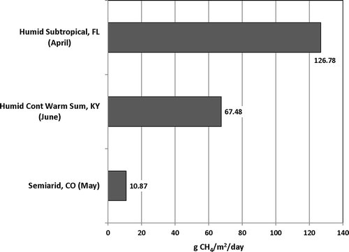
depicts the campaign results for the working face sites. These areas were difficult to access and most often were studied on weekends so as to not interfere with landfill operations. The measured fluxes from the working face were approximately 85 g CH4/m2/day in a semiarid Colorado climate, with humid continental cool summer Wisconsin climates ranging from 116 to 156 g CH4/m2/day and a humid subtropical Mississippi climate at 207 g CH4/m2/day. Temporary soil covers were nearly as difficult to access but three evaluations were accomplished as presented in Once again, the semiarid climate had the lowest emission rate at approximately 11 g CH4/m2/day, followed by the humid continental warm summer Kentucky site at 67 g CH4/m2/day and finally the humid subtropical at just under 127 g CH4/m2/day. The data suggest that temporary cover of soil alone can reduce methane emissions by about 50% over noncovered waste.
Figure 9. Working face flux results for three climate types based upon the MLRM flat equation to calculate ACF for binned campaign averages.
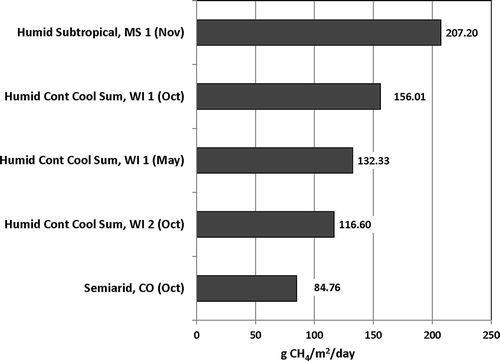
Figure 10. Temporary soil cover flux results for three climate types based upon the MLRM flat equation to calculate ACF for binned campaign averages.
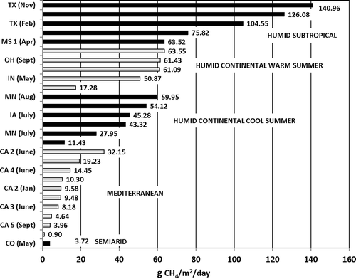
Significant measurements were conducted on intermediate soil covers due to ease of availability and the fact that they often constitute the majority of the landfill cover. indicates that there is a correlation between climate type, that is, average annual temperature and rainfall, and the amount of methane lost from the landfill surface. Waste is exposed to the elements both in transport and following placement. Drier waste results in slower methane production and this is reflected in the data. The only semiarid site studied in Colorado was found to be 3.72 g CH4/m2/day. The four California Mediterranean sites ranged from 0.90 to 32.15 g CH4/m2/day. The Lancaster, CA, site received by far the least precipitation at 7.4 inches/year and the campaign average of 0.90 g CH4/m2/day flux from the intermediate soil cover was the lowest measured. The humid continental cool summer locations in Minnesota, Iowa, and Wisconsin ranged from 11.43 to 59.95 g CH4/m2/day, the humid continental warm summer locations in Indiana, Ohio, and Virginia ranged from 17.28 to 63.55 g CH4/m2/day, whereas the humid subtropical sites, receiving the highest annual rainfall, ranged from 63.52 to 140.96 g CH4/m2/day.
Figure 11. Intermediate soil cover flux results for five climate types based upon the MLRM flat equation to calculate ACF for binned campaign averages.
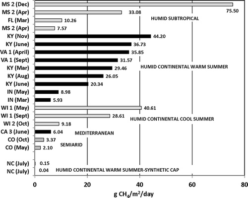
Final soil covers are shown in Once again the order of increasing methane emissions are semiarid (2.10–3.37 g CH4/m2/day), Mediterranean (6.04 g CH4/m2/day), humid continental cool summer (9.18–40.61 g CH4/m2/day), humid continental warm summer (5.93–44.20 g CH4/m2/day), and finally humid subtropical (7.57–75.50 g CH4/m2/day). It is important to note that the one closed landfill with a geosynthetic plastic cap covered with soil in North Carolina generally showed atmospheric background methane levels and the generation of a measurable methane flux is difficult under these conditions. Two data sets at that site gave results of 0.04 and 0.15 g CH4/m2/day.
Figure 12. Final soil cover flux results for five climate types based upon the MLRM flat equation to calculate ACF for binned campaign averages. The NC location is a synthetically covered closed site with gas collection.
The variation in these data may well be explained by the type of soil used for cover (sand vs. clay, for example), soil cover thickness, and landfill operational practices. The western Mediterranean landfills, for example, generally used just 30–45 cm of sandy clay soil for intermediate cover, as compared to 0.6 m loam to clay soils for most of the humid continental sites. Final soil covers ranged from 1 to 2 m in soil thickness at all landfills. The data suggest that higher temperatures and rainfall result in higher methane emissions.
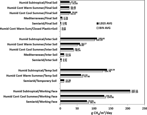
Finally, a comparison was made by combining and averaging all the results for the VRPM average leg results within a climate and cover type and comparing to the same using binned scans results. Most importantly, the plot in shows that the two data averaging methods resulted in little difference in the overall flux estimate for a climate type category. shows that within each cover type there is an increase in methane lost to the atmosphere going from the working face to final cover. The better the cover, the lower the flux becomes. The lowest emissions came from semiarid landfills and the highest from humid subtropical. The only exception is for final soil covers where there seems to be emission control equalization for humid continental cool and warm summer and humid subtropical climates at 25–30 g CH4/m2/day. For the final cover, semiarid climate is lowest at <3g CH4/m2/day and Mediterranean is about 6 g CH4/m2/day following the pattern for the other cover types. Once again, it can be pointed out that a synthetically covered landfill in North Carolina gave the lowest flux results for the entire study with leg results at 0.2 g CH4/m2/day and binned results at 0.9 g CH4/m2/day.
Figure 13. Comparison of all campaign leg flux averages and all campaign binned flux averages for all climate types.
Conclusions
Optical remote sensing using OTM-10 is a method that may have application for the landfill industry. However, the fact that only 31% of the data collected fulfilled the quality assurance/quality control (QA/QC) requirements for qualifying data is a concern. The method is at times not easy to apply to the complex topography of a landfill and there are areas of landfills that are not accessible to the technique. Nonetheless, the research helped to identify measurement difficulties and possible approaches to resolve them. The work also added to the understanding of key factors affecting landfill methane emissions. The models used to estimate the surface area contributing to the measured g/sec VRPM emissions and conversion to g CH4/m2/day were useful and the results agreed reasonably well, although the basis for each approach was quite different. The multiple linear regression model was based upon field releases of tracer gases, whereas the Pasquill stability-ISC3/U.S. EPA OTM-10 simulation model was virtual, but also accounted for atmospheric stability. The averaging of all results for a specific site cover type over the course of a day for all VRPM results (binning) may prove to be the most unbiased method for handling data. The OTM-10 method may be used to examine specific cover types on a landfill surface with an individual VRPM plane or may be used in certain situations to collect data for and entire landfill. The data collected and evaluated here, even with the obvious variability among landfills, strongly indicates that climate plays an important role in landfill methane emissions, as does cover type. The collection of optical remote sensing data for each cover type at a specific landfill combined with the associated surface area might allow approximation of the surface methane emissions for the total landfill surface. However, other methods, such as the tracer gas correlation technique, exist for estimating total landfill methane emissions (CitationCzepiel et al., 1996; CitationGalle et al., 2001; CitationScheutz et al., 2011).
Related Research Data
References
- Abichou , T. , Chanton , J. , Powelson , D. , Fleiger , J. , Escoriaza , S. , Lei , Y. and Stern , J. 2006 . Methane flux and oxidation at two types of intermediate landfill covers . Waste Manage. , 26 : 1305 – 1312 .
- Abichou , T. , Clark , J. , Tan , S. , Chanton , J. , Hater , G. , Green , R. , Goldsmith , D. , Barlaz , M. and Swan , N. 2010 . Uncertainties associated with the use of OTM-10 to estimate surface emissions in landfill applications . J. Air Waste Manage. Assoc. , 60 : 460 – 470 . doi: 10.3155/1047-3289.60.4.460
- Abichou , T. , Powelson , D. , Chanton , J. , Escoriaza , S. and Stern , J. 2006 . Characterization of methane flux and oxidation at a solid waste landfill . J. Environ. Eng. , 132 : 220 – 228 .
- ARCADIS U.S., Inc . 2007 . ARCADIS Flux Calculator Software for VRPM Analysis,Version 1.09 Beta
- Babilotte , A. , Lagier , T. , Fianni , E. and Taramini , V. 2008 . Fugitive methane emissions from landfills: a field comparison of five methods on a French landfill . Proceedings of the Global Waste Management Symposium; Copper Mountain, CO , September : 8 – 10 . 2008
- Barlaz , M.A. , Chanton , J.P. and Green , R.B. 2009 . Controls on landfill gas collection efficiency: instantaneous and lifetime performance . J. Air Waste Manage. Assoc. , 59 : 1399 – 1404 . doi: 10.3155/1047-3289.59.12.1399
- Bogner , J. and Spokas , K. 1993 . Landfill CH4: rates, fates and role in global carbon cycle . Chemosphere. , 26 : 369 – 386 .
- Chanton , J. , Abichou , T. , Langford , C. , Hater , G. , Green , R. , Goldsmith , D. and Swan , N. 2010 . Landfill methane oxidation across climate types in the U . S. Environ. Sci. Technol. , 45 : 313 – 319 .
- Chanton , J.P. , Powelson , D.K. and Green , R.B. 2009 . Landfill cover methane oxidation, is a 10% default value reasonable? J . Environ. Qual. , 38 : 654 – 663 .
- Czepiel , P. , Mosher , B. , Harris , R. , Shorter , J. , McManus , J. , Kolb , C. , Allwine , E. and Lamb , B. 1996 . Landfill CH4 emissions measured by enclosure and atmospheric tracer methods . J. Geophys. Res. , 101 : 16711 – 16719 .
- Galle , B. , Samuelsson , J. , Svensson , B.H. and Borjesson , G. 2001 . Measurements of methane emissions from landfills using a time correlation tracer method based on FTIR absorption spectroscopy . Environ. Sci. Technol. , 35 : 21 – 25 .
- Goldsmith , C.D. , Hater , G. , Green , R. , Abichou , T. , Barlaz , M. and Chanton , J. 2008 . Comparison of optical remote sensing with static chambers for quantification of landfill methane emission . Proceedings of the Global Waste Management Symposium , Copper Mountain, CO, September 8–10, 2008
- Hashmonay , R.A. and Yost , M.G. 1999 . Innovative approach for estimating gaseous fugitive fluxes using computed tomography and remote optical sensing techniques . J. Air Waste Manage. Assoc. , 49 : 966 – 972 .
- Intergovernmental Panel on Climate Change . 2001 . Climate Change 2001: The Scientific Basis , Edited by: Joos , F. , Ramirez-Rojas , A. , Stone , J.M.R. and Zillman , J. 46 – 47 . Cambridge : Cambridge . Press
- Reinhart , D. and Townsend , T. 1998 . Landfill Bioreactor Design & Operation , Boca Raton , FL : Lewis Publishers .
- Scheutz , C. , Samuelsson , J. , Fredenslund , A.M. and Kjeldsen , P. 2011 . Quantification of multiple methane emissions sources at landfills using a double tracer technique . Waste Manage. , 31 : 1009 – 1017 .
- Shores , R. , Harris , D. , Thompson , E. , Vogel , C. , Natschke , D. and Hashmonay , R. 2005 . Plane-integrated open-path Fourier transform infrared spectrometry methodology for anaerobic swine lagoon emission measurements . Appl. Eng. Agric. , 21 : 487 – 492 .
- Spokas , K. , Bogner , J. , Chanton , J. , Morcet , M. , Aran , C. , Graff , C. , Moreau-Le Golvan , Y. and Hebe , I. 2006 . Methane mass balance at three landfill sites: what is the efficiency of capture by gas collection systems? . Waste Manage. , 26 : 516 – 525 .
- The Weather Channel, 2011 http://www.weather.com/weather/wxclimatology/monthly/USCA0783 (http://www.weather.com/weather/wxclimatology/monthly/USCA0783) (Accessed: 6 June 2011 ).
- Thoma , E. , Green , R. , Hater , G. , Goldsmith , C. , Swan , N. , Chase , M. and Hashmonay , R. 2010 . Development of EPA OTM-10 for landfill applications . J. Environ. Eng. , 136 : 769 – 776 .
- U.S. Environmental Protection Agency, 1995. User's Guide for the Industrial Source Complex (ISC3) Dispersion Models. Version 2. U.S. Environmental Protection Agency; Research Triangle Park, NC: Office of Air Quality Planning and Standards Emissions http://www.epa.gov/scram001/userg/regmod/isc3v2.pdf (http://www.epa.gov/scram001/userg/regmod/isc3v2.pdf) (Accessed: 22 February 2011 ).
- U.S. Environmental Protection Agency, 1998. AP-42 Emission Factors for Municipal Solid Waste Landfills—Supplement E. Washington, DC: U.S. Environmental Protection Agency http://www/epa.gov/ttn/chief/ap42/ch02/final/c02s04.pdf (http://www/epa.gov/ttn/chief/ap42/ch02/final/c02s04.pdf) (Accessed: 22 February 2011 ).
- U.S. Environmental Protection Agency, 2005. Landfill Gas Emissions Model (LandGEM) Version 3.02. Research Triangle Park, NC: U.S. Environmental Protection Agency http://www.epa.gov//ttncatc1/dir1/landgem-v302-guide.pdf (http://www.epa.gov//ttncatc1/dir1/landgem-v302-guide.pdf) (Accessed: 22 February 2011 ).
- U.S. Environmental Protection Agency, 2006. EPA Test Method (OTM-10): Optical Remote Sensing for Emission Characterization from Non-Point Sources. U.S. Environmental Protection Agency; Research Triangle Park, NC: Technology Transfer Network Emission Measurement Center http://www.epa.gov/ttn/emc/prelim/otm10.pdf (http://www.epa.gov/ttn/emc/prelim/otm10.pdf) (Accessed: 22 February 2011 ).
- U.S. Environmental Protection Agency . 2007 . Evaluation of Fugitive Emissions Using Ground-Based Optical Remote Sensing Technology. EPA/600/R-07/032 , Research Triangle Park , NC : U.S. Environmental Protection Agency .