ABSTRACT
The Maderö wreck was discovered in the 1960s in the Stockholm Archipelago, Sweden. An archaeological investigation undertaken in 2022 included the inspection and documentation of visible ship parts, sampling for dendrochronological analysis and sampling for ICP analysis from the brick cargo. The results show that the wood originates from the Baltic Sea area and was felled after 1467, while the clay for the brick originates from the Mecklenburg-Vorpommern area. The ship's technical analysis shows that it is a large clinker-built merchant ship. Traces of iron on a recovered stone shot indicate that the ship was armed when it sank.
RESUMEN
El pecio Maderö fue descubierto en la década de 1960 en el archipiélago de Estocolmo en Suecia. Una investigación arqueológica llevada a cabo en 2022 incluyó la inspección y documentación de partes visibles del barco, la toma de muestras para análisis dendrocronológico y para análisis ICP del cargamento de ladrillos. Los resultados muestran que la madera proviene del área del mar Báltico y que fue talada después de 1467, mientras que la arcilla del ladrillo tiene su origen en el área de Mecklemburgo-Pomerania. El análisis técnico de la embarcación muestra que es un barco mercante construido a tingladillo. Los rastros de hierro en un proyectil de piedra recuperado indican que el barco iba armado cuando se hundió.
摘要
马德罗号沉船于 20 世纪 60 年代在瑞典斯德哥尔摩群岛被发现。 2022 年进行的考古调查包括检查和记录船体可见部分、木材取样以便进行树木年代学分析,以及提取砖块货物样本做 ICP 检验。其结果表明,船材来自波罗的海地区,砍伐时间在 1467 年之后,而砖块的粘土则来自梅克伦堡-前波莫瑞地区。对该船的技术分析表明,它是一艘大型鳞状搭接商船。打捞出的石弹上的铁质痕迹表明,该船沉没时装备有武器。
摘要
馬德羅號沉船於 20 世紀 60 年代在瑞典斯德哥爾摩群島被發現。 2022 年進行的考古調查包括檢查和記錄船體可見部分、木材取樣以便進行樹木年代學分析,以及提取磚塊貨物樣本做 ICP 檢驗。其結果表明,船材來自波羅的海地區,砍伐時間在 1467 年之後,而磚塊的粘土則來自梅克倫堡-前波莫瑞地區。對該船的技術分析表明,它是一艘大型鱗狀搭接商船。打撈出的石彈上的鐵質痕跡表明,該船沉沒時裝備有武器。
المُستخلص
تم اكتشاف حُطام ماديرو في أرخبيل ستوكهولم بالسويد في الستينيات. ولقد تضمن التحقيق الأثري الذي تم إجراؤه في عام ٢٠٢٢ فحص وتوثيق الأجزاء المرئية من السفينة، إلي جانب أخذ عينات لتحليل تاريخ الأخشاب المستخدمة في بناء السفينة وأخذ عينات من حمولة القرميد لإجراء تحليل البلازما المقترنة حثياً. ولقد أظهرت النتائج أن منطقة بحر البلطيق كانت مصدر الأخشاب والذي تم القيام بتقطيعه بعد عام ١٤٦٧، في حين أن منطقة مكلنبورغ-فوربومرن كانت مصدر الطين الخاص بالقرميد. ولقد أظهر التحليل التقني للسفينة أنها كانت سفينة تجارية كبيرة بُنيت بطريقة الكلنكر. وتشير آثار الحديد الموجودة على طلقة حجرية تم انتشالها، إلى أن السفينة كانت مسلحة عندما تعرضت للغرق .
PALABRAS CLAVE:
Background
That there is an old wreck in the waters outside Maderö in the Stockholm Archipelago has been known for a long time in local tradition. The earliest reliable account that divers have visited the site is from 1969 when Stockholms Sportdykarklubb (Stockholm Recreational Diving Club) made an inventory of the natural harbour Kohamn, in which the wreck is located (). The divers recovered ship timbers and three stone cannon balls. In 1967 the Swedish Heritage Act was extended to include old shipwrecks, however, throughout the 1960s it does not seem to have been consequently enforced. Only one of the three stone shot found its way into the collections of the Swedish Maritime and Transport Museums (SMTM) (see for instance Cederlund, Citation1983, pp. 224–225; Eriksson, Citation2014, p. 28).
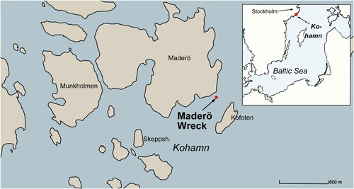
Figure 1. Location map (Niklas Eriksson).
The divers who found the wreck also made a sketch of the site, which is kept in the SMTM archives. It shows a large, partly disintegrated clinker-built hull laden with bricks. In the sketch the keelson is preserved in situ. With its large mast step, the keelson provides an impression of a medieval vessel. In 2003 diving at the wreck revealed further observations underlining the medieval dating, such as a crossbeam with notches at its ends, revealing that it protruded the hull side, but also that the cargo consists of medieval bricks. Documentation of the site was carried out by the corresponding author together with volunteer divers from the now-decommissioned Diving Club Dykvännerna. The archaeological documentation was not completed nor published at that stage and it was not until recently that the opportunity to continue the investigation at the site arose.
A new survey
In 2020, the Centre for Maritime Studies (CEMAS), which is a collaboration between Stockholm University (SU) and SMTM, received a grant from Riksbankens jubileumsfond for the research programme The Lost Navy, Sweden’s “Blue” Heritage circa 1450–1850. The programme is a collaboration between historians, ethnologists and archaeologist both at SMTM and at SU. The programme includes 11 different sub-projects, of which the corresponding author has a sub-project entitled A History of Swedish Naval Architecture 1450–1850.
Chronologically, the study has its departure before the introduction of the purpose-built warships in Northern Europe (see, for instance, Adams, Citation2013; Bill, Citation2002; Eriksson, Citation2021a). Knowledge of large late medieval combined merchant and fighting ships is limited. As stone shot have been recovered from the otherwise brick-laden ship, the Maderö wreck appears as an illustrative and interesting example of a merchant vessel that was large and sturdy enough to carry artillery. It was thus decided to have a new, closer look at the site.
This new survey of the Maderö wreck had the following objectives:
To gather information in the form of plans and drawings of the preserved parts of the hull structure that is exposed above the seabed. This recording of the coherent hull structure could be used to make a tentative assessment of the ship’s architecture, the construction techniques involved and the main dimensions of the hull.
To take wood samples for dendrochronological analysis and brick samples for inductively coupled plasma mass atomic emission spectrometry (ICP-MA/ES) analysis in order to learn more about the vessel’s date, origin and societal context.
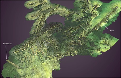
Due to limited time in the field, recording and photography were concentrated on areas with concentrations of ship timbers, leaving out the areas of empty seabed in between as well as the parts covered with sea growth or sediments (). The 3D file served as the basis for creating hand-drawn 2D drawings of the site, incorporating notes and measurements collected during the 2003 fieldwork as well.
Figure 2. Photogrammetric model of the dramatic Maderö wreck. The foremost end of the keel rests in 17 m of water whereas the stern is located at 22 m. Due to limited time the fieldwork photography was concentrated in the areas with ship timbers, leaving out the empty spaces of seabed in between (Jim Hansson/SMTM).

Description of the wreck site
The Maderö wreck rests on a slope with the bow pointing diagonally towards the shoreline of the Maderö island, hence the wreck’s working name (). The bow has totally disintegrated but the keel is preserved in its entire length. The foremost end of the keel is located in 17 m of water whereas the depth at the stern is 23 m. Astern of the wreck the seabed slopes down to more than 30 m, which means that parts of the now disintegrated bow might have fallen down towards the stern, but also that parts of the vessel may be located in deeper water. The present survey focused on the concentrated wreck area.
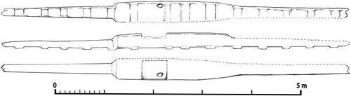
Figure 3. Site plan compiled from photogrammetry and underwater measurements (Niklas Eriksson).
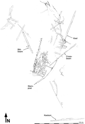
The sternpost reveals that the coherent portion of the hull has an approximately 30-degree list to port. The port quarter is preserved almost all the way up to the gunwale, but is covered by remains of the cargo, sediments and loose ship parts. The forward part of the portside has disintegrated. The starboard side is almost entirely gone, except for the lowest strakes of planking, which are still attached to the sternpost, and a few floor timbers.
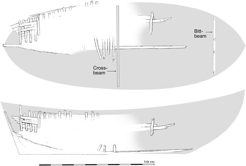
An accumulation of planks and frames are located south of the coherent hull area and might derive from the bow or the starboard side. Just south of the coherent hull side there is a so-called bitt beam, originally placed in the ship’s bow, which illustrates the site formation process where the missing parts of the forward hull have fallen down the slope.
Together with several other islands, Maderö forms the natural harbour basin of Kohamn which is frequently used by anchoring vessels. This activity has recurrently affected the wreck during the more than 500 years that has passed since it sank. The most visible recent damage that anchorage has caused to the wreck is that the keelson, depicted in situ on the sketch from 1969, has moved more than 15 m out of place and is now located east of the coherent hull. It was already located at this spot in 2003 but has since then been rotated 90 degrees. Other recent traces on the wreck are fishing nets and a modern sailing boat anchor as well as several fishing nets stuck in the hold.
Description of the hull
Despite the frequent use of the harbour basin and extensive traces of anchoring, substantial portions of the Maderö wreck are still intact (compare ). All observed timbers and planks in the hull appear to be made of oak. The forward end of the T-shaped keel rests on an exposed rock and the keel has bent under the weight of the brick cargo. The forward end of the keel has a pronounced scarf, where the lowest end of the stem was attached. Unfortunately the scarf is heavily eroded so it is not possible to determine if it was shaped with a hook or not. The aft end of the keel is embedded in sediment together with the lower end of the sternpost. The upper end of the sternpost has a T-shaped cross-section, indicating a round and wide stern.
Figure 4. Plan of the coherent hull structure with the bow pointing to the right. The numbers correspond to the dendro samples; D1 and D2 are samples from tangentially converted hull planks whereas D6, D7 and D9 are radially converted hull planks; D4 and D5 are ceiling planks; D3 is a floor timber; and D8 is probably a crossbeam. T five samples used for ICP analyses: 1, 3 and 4 are tiles, whereas 2 and 5 are bricks (Niklas Eriksson).
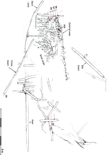
The hull is clinker-built from the keel all the way up to the uppermost preserved strake and the planks are attached to each other using iron nails with square rivets between 22–25 mm in size. The strakes of planking are between 32 and 35 cm wide. The metal has corroded away but traces are clearly visible on the surface of the wood. The frames are made of compass timbers and attached to the planking with dowels.
Two ceiling planks are visible at the stern of the ship relatively high up on the hull side. They are spaced and separated far apart and it seems likely that originally there was another ceiling plank between the two. On the outside of the planking there is an external wale that runs on the outside of the planking, to fender it off and protects it from wear.
Even though the portside is preserved almost all the way to the gunwale in the stern, not much is preserved of the crosswise construction, except for the above-mentioned bitt beam and what appears to be a loose crossbeam, located diagonally across the keel.
The bitt beam was found loose on the seabed just south of the coherent portside ( and ) but the shape and angle of the ends of this timber indicates that it was originally placed towards the forward end of the hull. The ends of the beam also reveal that it has fitted, inset into the hull planking, with the ends protruding through the hull side.
Figure 5. The bitt beam discovered loose on the seabed. Note the ends with notches to be secured in the hull planking and the standing bitt (Niklas Eriksson).
On the upper side of the timbers a short standing bitt is attached in a mortise and secured with a dowel. Another mortise is located in symmetry with this standing bitt, which means that originally there was another short standing timber on the beam. Such bitt beams are known from several late medieval and early modern ships and are usually located in or just above deck-level in the bow of the ship. The two standing bitts were used to belay the anchor cable. On clinker-built hulls the bitt beams usually protrude from the hull planking, for instance on the Ringaren wreck (Svenwall, Citation1994, p. 60), a feature also visible on the 15th-century Ebersdorff ship model (Christensen & Steusloff, Citation2012). Some early carvel-built ship-finds in the Baltic area also reveal protruding bitt beams (Adams, Citation2013, p. 83; Eriksson, Citation2015, p. 23). Another example of a carvel-built hull with a protruding bitt beam is the Mataró Model at the Maritime Museum Rotterdam, from around 1450 (De Meer, Citation2009).
The loose crossbeam is almost exactly 7 m long and provides an indication of the breadth of the hull. It appears as if the beam ended inside the hull rather than protruding through the planking in the same way as the bitt beam.
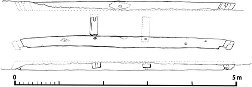
As mentioned above, the 7 m-long keelson has been removed since divers first discovered the wreck. The timber was tilted over at some point during the last 15 years and it now rests with the square notch for the mast covered in sediment, though fortunately the square notch was photographed and measured in 2003. The keelson is made from a single piece of oak, around 50 cm wide at the most, narrowing towards both ends and rebated onto the top of the floor timbers ().
Figure 6. The keelson which has been moved since the wreck was discovered in the 1960s (Niklas Eriksson).
Hull dimensions
One of the objectives of the survey was to assess the general characteristics of the ship’s architecture and the main dimensions of the hull. The bow of the Maderö ship has disintegrated and the stem together with the entire bow is missing. However, the length of the keel provides an impression of the ship’s original length. Whereas the foremost end of the keel is visible, the aftermost end is buried in the seabed. The sternpost is still attached to the keel and it is possible to determine its approximate extension in the stern. The length of the keel is estimated at 15.6 m.
The only preserved crossbeam was found loose, but as it is 7 m long it appears likely that it was placed in the vicinity of the greatest breadth amidships. The bitt beam was originally located towards the forward end of the hull and thus does not provide information regarding the maximum breadth. Under sediment and the brick cargo, the portside quarter of the hull side is coherent and well preserved. To what extent the hull side has deformed and altered shape is difficult to tell without removing the brick cargo. The impression is that the distortion to the hull side does not appear to be very severe. The aftermost part of the preserved hull side has fallen out slightly, but just aft of amidships the hull appears to have kept its original curvature. At this part the hull is slightly less than 8 m wide, which fits well with the crossbeam’s length (compare ).
Figure 7. Interpretation and reconstruction to visualise the possible original dimensions of the hull and the approximate location of the crossbeam and the bitt beam, compiled from 3D photogrammetry and underwater measurements (Niklas Eriksson).
Several large late medieval ships reveal long curved stems with a considerable rake (see Auer & Maarleveld, Citation2013, p. 35, with references) and shipbuilding treatises from the late 16th and early 17th centuries that describe the construction of carvel-built warships indicate that the radius of the stem should be more or less equal to the width of the hull (cf. Bellamy, Citation2006, p. 10; Eriksson, Citation2021a, p. 122; Eriksson, Citation2023, pp. 326-327). If the Maderö ship was built with such proportions, the overall length between stem and sternpost would be close to or even slightly more than 20 m.
Dendrochronological analysis
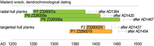
Ten samples for dendrochronological analysis, all oak (Quercus sp.), were sawn from the hull structure. The distribution of these samples is shown in . Sample 3, which is a floor timber, and sample 8, from the crossbeam, only contained 21 and ca 40 tree rings, respectively, and were not examined further. Samples 4 and 5, which were sawn from the ceiling planks, contained 47 and 45 tree rings, respectively, and sample 10, also a ceiling, contained 54. These three samples, which all derive from the interior of the ship, were analysed through dendrochronology but could not be dated due to the short tree-ring series (Daly, Citation2022).
The remaining five samples, all from the outer planking, were dated. Four of these contain more than 100 tree rings. Among these samples two groups were identified dendrochronologically. Two tangentially converted planks form one group while three radial planks indicate a separate group. The samples from the two tangentially converted planks are from the forward part of the preserved hull structure, which means that they were originally placed amidships (D1 and D2 in ), whereas the samples from the radially converted planks are located near the stern (D6, D7 and D9 in ).
Unfortunately none of the samples contained sapwood. The outermost complete ring is sample 6, which is one of the radially converted planks in the stern. This ring was formed in AD 1457 and one additional partial ring is observed outermost on the sample. Allowing for missing sapwood, the felling of the tree can be placed at after AD 1467. (For estimating the felling date of the oak trees that were used for the radial planks, a sapwood average for northern Poland [15 years -6/+9; Wazny, Citation1990, p. 213] was used). For the two tangential planks, however, we used the slightly longer estimate for northern Germany (ca 20 sapwood years -5/+10; Hollstein, Citation1980). As shown in , the felling date estimates for the trees that each plank was made from are terminus post quem; the dendrochronology does not give a fine enough resolution to allow us to state that they are all parts of the original structure of the ship rather than repairs.
Figure 8. The chronological position of the dated samples from the Maderö wreck. The green and orange bars represent the position in time of the preserved tree rings in each sample. No sapwood is preserved on the samples, so the interpretation of the felling date for each sample, allowing for missing sapwood, is indicated with an arrow.
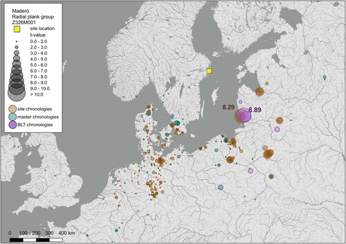
It is interesting, however, that the provenance of the wood differs between the two groups. The radial outer planking, used for the curved planking close to the sternpost, correlates best with site chronologies for the eastern Baltic region (), in that the average for these correlates best with a site chronology from Klaipeda on the Lithuanian Baltic coast (Vitas, Citation2020), and with a master chronology built from painted oak panels, identified as having their origin in coastal Lithuania (Daly & Tyers, Citation2022). These planks also correlate strongly with tree ring datasets for other late 15th and early 16th century shipwrecks, but also with ecclesiastical artworks that were made of oak from the eastern Baltic region.
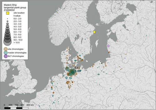
Figure 9. Map showing the distribution of the correlations achieved between the average for the radial plank group from the Maderö wreck and a network of oak chronologies for Northern Europe. The correlation statistic used is Student’s t-test, where the tree ring data is normalised according to Baillie and Pilcher (Citation1973). The circle on the map is sized according to the t-value. The underlying tree ring dataset is described in Daly (Citation2007), but recent additions to this dataset for Lithuania, Latvia, Belarus and Russia have been added. The purple dots represent art-historical chronologies (Daly & Tyers, Citation2022). The background map is from the Global Administrative Areas project (gadm.org; https://geodata.ucdavis.edu/gadm/gadm4.1/work/ downloaded on 10 January 2023). The river data are from Lehner and Grill (Citation2013) (www.hydrosheds.org, accessed 3 March 2020). The map is generated using QGIS software (QGIS.org, Citation2021). (Aoife Daly/dendro.dk).
In contrast, the two samples from the tangential converted planks amidships correlates with chronologies for Lübeck (). The correlations with site chronologies from Lübeck give a maximum t-value of 7.42, while a master chronology for the city correlated with the tangential plank tree ring curve at t = 8.09. This group was also kindly checked with chronologies from further east, along the Southern Baltic coastal region, and the highest correlations still presented with chronologies from the Lübeck environs (Karl-Uwe Heuβner, pers. comm.).
Figure 10. Map showing the distribution of the correlations achieved between the average for the tangential plank group from the Maderö wreck and a network of oak chronologies for Northern Europe. The correlation statistic used is Student’s t-test, where the tree ring data is normalised according to Baillie and Pilcher (Citation1973). The circle on the map is sized according to the t-value. The underlying tree ring dataset is described in Daly (Citation2007), but recent additions to this dataset for Lithuania, Latvia, Belarus and Russia have been added. The purple dots represent art-historical chronologies (Daly & Tyers, Citation2022). The background map is from the Global Administrative Areas project (gadm.org; https://geodata.ucdavis.edu/gadm/gadm4.1/work/ downloaded on 10 January 2023). The river data is from Lehner and Grill (Citation2013) (www.hydrosheds.org, accessed 3 March 2020). The map is generated using QGIS software (QGIS.org, Citation2021) (Aoife Daly/dendro.dk).
No scarfs in the planking have been observed at the Maderö wreck but there is no doubt that each strake of planking has been built up of several boards scarfed together. Radially converted planks are stronger and more flexible, thus allowing bending, which is a likely reason why they are found in the stern where the hull side is very curved, and the boards are bent in a complex manner. That the dendrochronology finds that these radial planks are from an eastern Baltic source suggests that the long straight-grained trees from this region were specifically sought after, exactly for the bending quality that they provided.
The place where the ship was built could thus be in the vicinity of Lübeck, considering the frequency with which we have evidence for transport of planks from the eastern Baltic (Daly, Citation2021; Daly et al., Citation2021; Færch-Jensen & Daly, Citation2023; Von Arbin et al., Citation2022). However, considering that there are undated timbers from the wreck, particularly a frame with only 21 tree rings, it cannot be ruled out that the ship was built in a third region, using planks imported from two sources. The different origin of the wood suggests that the Maderö ship was built at a shipyard that brought in and imported material from a larger area, rather than relying on locally grown wood. The shipbuilders were able to select which boards were suitable to use in different parts of the planking.
The dendrochronological analysis of the Maderö wreck suggests that the ship is approximately contemporary with remains of a wreck found at Vejdyb (Bill, Citation1997; Daly, Citation1997; Rieck, Citation1986), and the eastern Baltic group from Maderö correlates well with one of the plank groups from Vejdyb. Dendrochronology of the planks from the Vejdyb ship demonstrated that it was built from trees felled ca AD 1465–75 and that its planks are from three Baltic sources. One group is from coastal Lithuania while another correlates best with a chronology that represents oaks from the Vistula River or its tributaries, in current-day Poland (Daly & Tyers, Citation2022). One of this ship’s framing timbers, made from a younger tree (47 tree rings), remains undated. A detail in the method of construction of the Vejdyb ship, where wooden pins were used to join the clinker planks, subsequently reinforced with rivets, prior to the addition of the frames, points to a building site in the Low Countries, where this method was employed within the first half of the 16th century (Overmeer, Citation2007). A shipwreck in Køge in Denmark, completed in the winter of 1526–27, also displays this feature, and is made with Eastern Baltic planking but framing timber from the Low Countries, again demonstrating the transport of planks for shipbuilding from the Eastern Baltic to the Netherlands (Daly, Citation2019; Færch-Jensen & Daly Citation2023). The Køge wreck has both radially and tangentially converted planking from a homogeneous Baltic source. The Vejdyb wreck clearly demonstrates the transport of timber planks from the Baltic, in the 1460–70s, and, indeed, represents an earlier occurrence of the combined wooden pin and rivet clinker plank fastenings.
The Eastern Baltic region became an enormously exploited source for oak for artwork and sculpture from the mid-14th century onwards, and is particularly represented in the dendrochronological record, from analysis of painted oak panels. This source was equally utilised for ship planking, as a growing number of wrecks from Northern Europe can be shown to have utilised this straight-grained planking for their hulls.
Origin of the cargo
The coherent port side is to a large extent covered by the cargo consisting of a mix of conventional rectangular bricks and specially shaped and profiled bricks used in niches around doors and windows in medieval buildings (). Among the cargo there are also a substantial amount of monk and nun roof tiles. Despite attempts during fieldwork and analysis of gathered material it has not been possible to establish any particular proportion between the different tiles or bricks, nor to discern a specific order in which they were loaded or stacked in the hold. The cargo likely moved aft and to the port side as the ship sank and landed on the seabed. Moreover, the continuous disturbance through anchoring vessels and the disintegrating of the hull has further moved the cargo around.
Figure 11. The Maderö wreck rests with a list and the bow pointing up towards land, which has caused the brick cargo to slide aft and to port (Jim Hansson/SMTM).
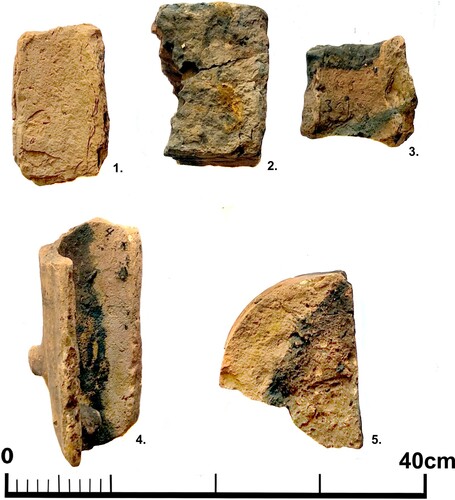
In order to attain knowledge about the origin of the cargo, five brick samples were analysed (). These were selected so that they represent different types of bricks and roof tiles. The samples were analysed through ICP-MA/ES. The aim of this method of analysis is to determine the geographical origin of the clays used for producing pottery, bricks, roof tiles, stove tiles, etc. (see for example Brorsson, Citation2013; Little et al., Citation2004). ICP-MA/ES is a chemical analysis that provides information on the chemical identity of a sherd by measuring a vast spectrum of elements down to extremely low concentrations (Golitko & Dussubieux, Citation2016). Twelve trace elements in particular (Al, Ca, Ce, Co, Cr, Ga, La, Mg, Mn, Ma, Sr and V) were measured and the result used to identify the origin of the clay from which each brick and tile is made. The selection was based on previous experience that demonstrated a reliable discriminating processing (see for example Thompson & Walsh, Citation1989).
Figure 12. Five samples were raised from the cargo to be used for ICP analysis. 1: roof tile; 2: brick; 3: roof tile; 4: roof tile; 5: profile brick. The location of the samples is shown in (Niklas Eriksson).
The ICP-MS analysis provides a large amount of data that can be statistically processed. The data are therefore organised in a factor analysis and a cluster analysis, which combine samples of the same chemical composition, and thus likely geological and geographical origin (see for example Little et al., Citation2004). It is important to note that the ICP-MS analysis is not biased by the treatment of the clay. In other words, a coarsely or finely worked clay that was originally taken from the same place will be placed into the same ICP group, while two fine clays from different places will be separated. The raw data for the ICP analysis of the bricks from the Maderö wreck are shown in .
Table 1. ICP analysis of bricks from the Maderö wreck. The elements form the basis for the interpretation of the provenance of the brick cargo (Torbjörn Brorsson).
The five samples can be divided into four groups, as the roof tiles Maderö 1 and Maderö 5 are identical (). These two would thus have been made in the same area. The other three samples that deviate might also be from the same area, or they may have another provenience. In order to establish this it is necessary to use a reference material from different areas of Europe in the analysis. The samples has been compared with the Ceramic Studies database of clays and ceramics from mainly Europe (created by T. Brorsson). The database contains of more than 14,000 samples.
Figure 13. The samples Maderö1 and Maderö5 have the same chemical composition. None of the five samples from the wreck have any similarities with ceramics from the Stockholm region (Torbjörn Brorsson).
As the wreck is located in the Stockholm Archipelago a possible provenience could be Stockholm. However, comparisons to bricks and ceramics made in the vicinity of Stockholm reveal that the material from the Maderö wreck deviates from this material (), which makes it possible to exclude Stockholm as a possible place of production.
The samples were also compared to reference material from other parts of Sweden, Denmark, The Netherlands, Germany and Poland. Of these, the only matches are from northern Germany. Samples 1 and 5, paired together, match a sample from Büssow in Mecklenburg-Vorpommern in north-eastern Germany (). Sample 2 corresponds with a sample from Penkun, in the vicinity of Büssow in Mecklenburg-Vorpommern. Samples 3 and 4 are similar to samples from Neubrandenburg, ca 60 km south of Greifswald in north-eastern Germany, also located in Mecklenburg-Vorpommern.
Figure 14. The bricks from the Maderö wreck have similarities with material from pottery and bricks from north-eastern Germany (Torbjörn Brorsson).
The analysis shows that a Scandinavian provenience of the bricks can be wholly excluded and that the five samples derive from products produced in Mecklenburg-Vorpommern. It appears likely that all samples are from products produced at a few brickyards and that both the roof tiles and the bricks have the same place of origin in the eastern parts of Mecklenburg-Vorpommern (see also Brorsson, Citation2022).
The increasing demand for bricks in medieval Stockholm is usually discussed in terms of increased domestic production (see Ljung et al., Citation2013, pp. 7–10, with references). The provenience of the cargo aboard the Maderö wreck sheds new light on this topic as it clearly reveals that bricks were imported.
Stone shot
The so-called Skanör Cog, dated to around 1390, is the earliest known example of a wreck with stone shot aboard in Scandinavian waters. A total of 14 stone shot were recovered, representing at least two calibres: 70–84 mm (7 shot) and 110 mm (7 shot) (Alopaeus, Citation1996, p. 51). The decades surrounding the turn of the 15th century were turbulent and saw a lot of piracy, and it is thus not surprising that cannons appear both in the historical and archaeological record around this time (Barfod, Citation1990, pp. 21–83). During the 15th century the use of artillery aboard ships increased dramatically (see for example De Vries, Citation1998, for overview).
It is known that large merchant ships could be used as fighting ships in connection to a specific conflict in the Middle Ages. For instance, the Hanseatic towns could muster a fleet to fend off enemies or pirates. To what extent medieval merchant ships were armed on their ordinary trading voyages is not known. As the Skanör Cog was found without any traces of cargo or ballast it is difficult to tell if it should be understood as a fighting ship or a merchant ship. This is why the stone shot from the heavily brick laden Maderö ship is so interesting.
As mentioned initially, at least three stone shot were recovered from the wreck in 1969 and 1970. According to reports from recreational divers two more stone shot were looted from the site during the summer of 1990 (Raä Fornsök, SMTM archive), which brings the total number of observed cannon balls to five. As diving has never been restricted or regulated at the site it is impossible to assess the original number of shot, as these may have been removed by unscrupulous divers or disappeared for other reasons without further trace. Unfortunately there is no information that reveals where aboard the ship the shot were observed or their calibre.
One single stone shot is preserved in the collections of the SMTM () and thus accessible for closer examination. It consists of a rock which is carved into a nearly perfect spherical shape, with a calibre of around 78 mm. Without information concerning the archaeological context where the stone shot were found aboard the ship it is difficult to be certain whether they were part of the cargo together with the bricks and tiles or if they derive from the ship’s own artillery.
Figure 15. Two views of the stone shot from the Maderö wreck in SMTM’s collection. Note the brownish colouring that surrounds the entire ball. The calibre is approximate 78 mm (Susanna Allesson-Nyberg/SMTM).
There is a brownish band that looks similar to rust around the entire outer circumference of the stone shot. The surface of the stone shot is darker in colour on one side of this band and lighter on the other. In order to obtain clues as to what might have caused these different colourations, they were analysed at the Archaeological Research Laboratory, Sweden, using a portable X-ray fluorescence detector (XRF). Three different spots on each of the three different coloured surfaces were analysed and the means of the detected elements were calculated and compared. The brownish rust band and the dark-coloured side gave a distinctively lower signal from silicon then the light-coloured side. This indicates that the coloured parts of the rock are indeed covered in a surface of a different composition since the silicon most probably reflects the minerals of the rock. The XRF signals from two elements in particular stand out in the analysis: iron and sulphur ().
Figure 16. Means of the relative XRF signals (mass percent) recorded on the differently coloured surfaces of the cannonball (Sven Isaksson).
The distinctively higher iron signal from the surface of the brownish band suggests that it is indeed traces of contact with metal iron. However, the conditions for preservation of iron are very poor at the wreck site. For instance, the iron nails and rivets that attach the strakes of planking together have all corroded away. The question is what kind of now totally corroded iron artefact could have left these traces on the stone shot? One possible explanation is that the rust is the remains of an attached iron and that it could have formed a part of an early bar or chain shot. However, we have been unable to find parallels to such shot made of stone. But perhaps there is another explanation?
Rust is a mixture of iron oxides, hydrous iron oxides and iron oxide-hydroxides, reddish to brownish in colour. Since the brownish band on the stone shot is also the surface highest in sulphur it is very likely that ferrous sulphides contribute as main components. Iron sulphides are formed in low-oxygen, low-pH environments; they are black or brown in colour and are insolvable in water, explaining why this band has been preserved. The varying signal from sulphur between the different surfaces is also revealing. Sulphides may form naturally in low-oxygen zones of lakes and oceans through sulphate-reducing bacteria. But if that would have been the cause here, one would expect the sulphur to be evenly distributed over the surface of the stone shot. In this case, one side – the dark-coloured side – shows a distinctively higher sulphur signal than the light-coloured side. This shows that this side of the stone shot has been exposed to a more sulphur-containing environment than the light-coloured side. Since sulphur is a main ingredient in gun powder a plausible inference from these observations is that this is a cannonball that was situated in the iron barrel of a loaded gun when the ship sank.
When the Maderö wreck sank the most commonly used cannons were wrought iron guns. These were usually chamber loaded which means that the charge of gunpowder was loaded into a loose chamber attached to the breech of the cannon when preparing for fire. The advantage of this system was that every cannon could be equipped with several chambers that could be switched and hence increased the rate of fire.
There are some examples of medieval cannons found loaded in a maritime context. The Marstrand bombard, for example, was discovered with an intact charge (von Arbin et al., Citation2023), but perhaps the most illustrative example is the so-called Riddarholmen ship, where three wrought iron breech loaded cannons were found together with no less than 43 chambers, of which several were loaded with both black powder and projectile (Eriksson, Citation2023, p. 318, 330–331; Fischer, Citation1983, pp. 33–38). It is thus not too far-fetched that the iron and sulphur on the cannon ball might derive from a cannon or a chamber that has been completely corroded away. A parallel is the late medieval ship Gribshunden, which is located in a similar environment and more or less contemporary with the Maderö wreck, where all the metal from the wrought iron cannons has rusted away, leaving empty stocks (Einarsson & Wallbom, Citation2002).
No empty stocks have been observed at the Maderö wreck, but on the other hand, swivel guns made entirely of wrought iron were in use by the end of the 15th century. Such a swivel gun would leave very few traces after more than 500 years at the site.
The question about the armament aboard merchant ships in general and the Maderö ship in particular must be left open for now, even if it seems likely that the ship actually had guns aboard. Future research on this and other wrecks will most likely provide new insights and arguments to this discussion.
The Kohamn area
The Maderö ship sailed and sank in the decades before or around the turn of the 16th century. By this point in time portolan maps were produced, depicting the sailing routes along the coasts of the Mediterranean and Africa with compass courses between larger mercantile centres and other important places. These maps are very accurate and reliable (for instance Blake, Citation2005, pp. 20–35).
In the late Middle Ages sea route descriptions on the Baltic were still communicated orally. From the late 16th century, these oral descriptions were compiled into printed books, such as or Laurentz Benedicht’s Søkartet offuer Øster og Vester Søen (Citation1568) or Lucas Janszzonz Waghenaer’s The Mariner’s Mirrour (Waghenaer & Ashley, Citation1588), which provide images and texts of such sea route descriptions.
The earliest printed sea route descriptions end abruptly in the southern part of the Stockholm Archipelago, about 100 km from the final destination and about 50 km from Kohamn where the Maderö ship sank. This may seem surprising as the sea route north of this point is very complicated and hazardous. Sailing to Reval (present day Tallinn), Visby, Stralsund, Kalmar or many other centres in the Baltic is fairly straightforward, as tall merchant houses, church towers and similar buildings are visible even from far out on the open sea. Sailing to Stockholm required a different strategy as the town is hidden behind a barricade of islands and rocks, impossible to map with available methods. Navigating was conducted through visual contact with land and the position of the ship was established using distinguishable and recognisable features on land, such as the colour of the cliffs, characteristic buildings, specific trees or other features.
Ships heading for Stockholm from Lübeck or any other departure in the Southern Baltic entered the archipelago through the Danziger Gatt strait. Small vessels could reach the city though the shallow passage through Baggenstäket, whereas larger vessels – like the Maderö ship – would have to make a U-turn around the archipelago and approach Stockholm from the north. The Dutch diplomat Antonis Goeteeris described it as follows: ‘you will have to circumnavigate the entire compass in order to sail out or in among the islands’ () (Goeteeris, Citation1917, p. 187, author’s translation; see also Eriksson, Citation2021b, p. 20; Eriksson, Citation2022, p. 119). It almost goes without saying that it is rare to have fair winds to transport a square-rigged cargo vessel on such a manoeuvre. This is why the natural harbours, such as Kohamn, formed by sheltering islands, are so important.
Figure 17. A ship sailing from Lübeck would enter the archipelago from the south through the Danziger Gatt strait. Small vessels could use the shallow passage though Baggenstäket whereas a large vessel – such as the Maderö ship – would have to make a U-turn left and enter Stockholm from the north. Kohamn, where the ship sank, is a natural harbour basin along the sea route (Niklas Eriksson).
As it was only possible to sail during daylight, ships were moored in natural harbours along the sea route. The most renown is Dalarö, which developed into a seaside entrance to the Swedish empire with a fortification and a customs office during the 17th century. Together with places like Älvsnabben, Djurhamn, Berghamn and not least Kohamn, these formed natural harbours where ships anchored while waiting for daylight or suitable winds. Kohamn is mentioned in Dutch cartographer Willem Janszoon Blaeu’s (1571–1638) description of the sea route through the archipelago outside Stockholm (Blaeu, Citation1625, p. 101), which illustrates the importance of this natural harbour basin. The Maderö ship may have sunk while at anchor, from coming adrift, from ice movements, leakage or something else. Several other wrecks are located in the Kohamn harbour basin but the Maderö ship appears to be the oldest.
Conclusions
The recording of the hull structure has revealed that the original length of the Maderö ship between stem and stern was around or slightly more than 20 m, whereas the breadth of the hull was approximately 8 m. This makes the Maderö ship a relatively large vessel by late medieval standards, even if there are several ships that are bigger.
The dendrochronological analysis revealed that the wood was felled after 1467, but as there were no sapwood in the samples the year of construction and sinking may be closer to the turn of the 16th century. The provenience of the wood, from different areas, indicates that the ship was – at least partly – built from imported wood rather than relying solely on local supply. It was built at a shipyard with a wood supply that was large enough to choose from different qualities for different parts of the vessel.
The ICP analysis of the cargo revealed that the clay in the bricks and tiles were similar to samples from Büssow, Neubrandenburg and Penkun, all in the Mecklenburg-Vorpommern area, which is not more than 20 km from Lübeck. It is thus tempting to suggest that the Maderö ship had its home port in either Mecklenburg-Vorpommern or Schleswig-Holstein and the city of Lübeck. The ship was probably built in this area as well.
Judging from the location of the wreck the Maderö ship was heading towards Stockholm when it sank. The provenience of the cargo appears a bit surprising in this context as it has been assumed that the domestic production of bricks and tiles could meet the demand of construction works. The cargo from the Maderö wreck opens up for new research regarding the import of building materials. Further studies and ICP analysis of material from standing medieval buildings in Stockholm may shed new light on this matter.
The large cargo of bricks and roof tiles reveals that the ship sank on a trading voyage. Despite this, there is information that at least five stone shot for cannons have been observed at the wreck. It is tempting to see these as evidence for the ship being armed. The rust and the sulphur observed on the one preserved stone shot may indicate that it was loaded into a cannon or a breech chamber when the ship sank. The question about the Maderö ship’s armament remains open to some extent. Further research on medieval shipwrecks will hopefully provide interesting comparisons and additional insights.
Authors contributions
Niklas Eriksson: research definition, interpretation of ship structure and landscape analysis, wrote original draft. Torbjörn Brorsson made analysis and wrote the part about the brick analysis, Aoife Daly made dendrochronological analysis and wrote the part on origin of timber, Jim Hansson photographed and processed 3D model and Sven Isaksson carried out and wrote the part about the XRF analysis on the stone shot.
Permission statement
Permission to take samples for dendrochronology and ICP-analysis from the Maderö Wreck was given to Niklas Eriksson at the Department of Archaeology and Classical Studies at Stockholm University by the Stockholm County Administration. Decision no. 431-8453-2021.
Acknowledgments
Thanks to ‘Lost Navy’ colleagues Patrik Höglund and Mikael Fredholm as well as members of the now decommissioned Diving Club Dykvännerna (DKD) for participation in diving and recording at the wreck site in 2003. Thanks also to Susanna Allesson-Nyberg for great help with the stone shot.
Disclosure statement
No potential conflict of interest was reported by the authors.
Additional information
Funding
References
- Adams, J. R. (2013). A maritime archaeology of ships: Innovation and social change in late medieval and early modern Europe. Oxbow Books, Limited.
- Alopaeus, H. (1996). Koggen från Skanör. Populär arkeologi, 51, 48–51.
- Auer, J., & Maarleveld, T. (2013). Skjernøysund 3 Wreck 2011, Esbjerg Maritime Archaeology Reports 5. University of Southern Denmark.
- Baillie, M.G.L., & Pilcher, J.R. (1973). A simple cross-dating program for tree-ring research. Tree-Ring Bulletin, 33, 7–14.
- Barfod, J. (1990). Flådens fødsel. Marinehistorisk Selskabs skrift nr. 22.
- Bellamy, M. (2006). David Balfour and early modern Danish ship design. The Mariner's Mirror, 92(1), 5–22.
- Benedicht, L. (Ed.) 1568, Søkartet offuer Øster og Vester Søen. Aff Laurentz Benedicht.
- Bill, J. (1997). Small scale seafaring in Danish waters AD 1000–1600 [PhD thesis]. University of Copenhagen, Denmark.
- Bill, J. (2002). Castles at sea: The warship of the high middle ages. In A. Nørgård Jørgensen (Ed.), Maritime warfare in Northern Europe: Technology, organisation, logistics and administration 500 BC–1500 AD: Papers from an international research seminar at the Danish National Museum, Copenhagen, 3–5 May 2000 (pp. 47–56). National Museum.
- Blaeu, W.I. (1625). The sea-mirrour containing, a briefe instruction in the art of navigation; and a description of the seas andMarinarkeologisk undersökning 2013–2015 coasts of the easterne, northerne, and vvesterne navigation. Amsterdam.
- Blake, J. (2005). The sea chart: The illustrated history of nautical maps and navigational charts. London: Conway.
- Brorsson, T. (2013). A new method to determine the provenance of pottery – ICP analyses of pottery from Viking age settlements in Northern Europe. In S. Kleingärtner, U. Müller & J. Scheschkewitz, (Eds.), Kulturwandel im Spannungsfeld von Tradition und Innovation. Festschrift für Michael Müller-Wille (pp. 59–66). Neumünster.
- Brorsson, T. (2022). ICP-analys av tegel från Maderövraket, Värmdö, Stockholms skärgård. Kontoret för Keramiska Studier, Rapport 204, Landskrona.
- Cederlund, C.O. (1983). The old wrecks of the Baltic Sea: Archaeological recording of the wrecks of carvel-built ships. BAR.
- Christensen, A. E., & Steusloff, W. (Eds.) (2012). Das Ebersdorfer Schiffsmodell von 1400: Ein authentisches Sachzeugnis des spätmittelalterlichen Schiffbaus in Nordeuropa = The Ebersdorf ship model of 1400. Dt. Schiffahrtsmuseum.
- Daly, A. (1997). Dendrokronologisk undersøgelse af skibsvrag fra Vejdyb udfor Hals, Aalborg Amt. Nationalmuseets Naturvidenskabelige Undersøgelser rapport 1997:12, Copenhagen.
- Daly, A. (2007). Timber, trade and tree-rings: a dendrochronological analysis of structural oak timber in Northern Europe, c. AD 1000 to c. AD 1650 [Unpublished PhD dissertation]. University of Southern Denmark. https://doi.org/10.5281/zenodo.3349667.
- Daly, A. (2019). Dendrochronological analysis of timbers from a ship found at Køge Harbour, KNV804, Denmark. Dendro.dk report 2019:72, Copenhagen.
- Daly, A. (2021). Timber supply for Vasa – New discoveries. Archaeonautica, 21, 261–266.
- Daly, A., & Tyers, I. (2022). The sources of Baltic oak. Journal of Archaeological Science, 139, 105550. https://doi.org/10.1016/j.jas.2022.105550
- Daly, A. (2022). Dendrochronological analysis of timbers from the Maderö shipwreck. Dendro.dk report 2022:65, Copenhagen.
- Daly, A., Domínguez-Delmás, M., & van Duivenvoorde, W. (2021). Batavia shipwreck timbers reveal a key to Dutch success in 17th-century world trade. PLoS ONE, 16(10), e0259391. https://doi.org/10.1371/journal.pone.0259391
- De Meer, S. (2009). The Mataró-model: World’s oldest ship model yields its secrets. Maritime History, the Scale Model as Reconstruction, 7, 28–49.
- De Vries, K. (1998). The effectiveness of fifteenth-century shipboard artillery. The Mariner's Mirror, 84(4), 389–399.
- Einarsson, L., & Wallbom, B. (2002). Fortsatta Marinarkeologiska undersökningar av ett fartygsvrak beläget vid St. Ekö, Ronneby kommun, Blekinge län. Kalmar läns museum.
- Eriksson, N. (2015). Skeppsarkeologisk analys. In J. Rönnby (Ed.), Gribshunden (1495) Skeppsvrak vid Stora Ekön, Ronneby, Blekinge, Marinarkeologisk undersökning 2013–2015 (pp. 13–32). MARIS Södertörn Univerity/Blekinge Museum.
- Eriksson, N. (2014). Urbanism under sail: An archaeology of fluit ships in early modern everyday life [Unpublished PhD thesis]. Södertörn University, Södertörn, Sweden.
- Eriksson, N. (2021a). The Bellevue Wreck: A recent survey of a large Late Medieval shipwreck in Dalarö Harbour, Sweden: A possible hulk?, International Journal of Nautical Archaeology, 50(1), 116–129.
- Eriksson, N. (2021b). The architecture of the early modern sea routes into Stockholm. In Ekström, S. & Müller, L. (Eds.), Facing the sea: Essays in Swedish maritime studies (pp. 15–40). Nordic Academic Press.
- Eriksson, N. (2022). Stormaktsskärgård – Marin landskapshistoria utmed farlederna mot Stockholm. Nordic Academic Press.
- Eriksson, N. (2023). Recent advancements in the Riddarholmen Ship puzzle: A new interpretation of the architecture of an early 16th-century clinker-built gun-carrying warship. International Journal of Nautical Archaeology, 52(2), 317–335.
- Færch-Jensen, J., & Daly, A. (2023, in press) Køge 2. A clinker-built shipwreck from the Medieval harbour of Køge, Zealand, Denmark, Acta Archaeologica, 94(1).
- Fischer, A. (1983). Riddarholmsskeppet: En skeppsarkeologisk beskrivning och bedömning [Unpublished bachelor's thesis]. Stockholm University, Stockholm, Sweden.
- Goeteeris, A. (1917) En holländsk beskicknings resor i Ryssland, Finland och Sverige 1615–1616: Trenne reseberättelser. Ôversätta och utgivna av S. Hildebrand, Stockholm.
- Golitko, M., & Dussubieux, L. (2016). Inductively Coupled Plasma-Mass Spectrometry (ICP-MS) and Laser Ablation Inductively Coupled Plasma-Mass Spectrometry (LA-ICP-MS). In A. Hunt (Ed.), The Oxford handbook of archaeological ceramic analysis (pp. 399–423). Oxford University Press.
- Hollstein, E. (1980). Mitteleuropäische Eichenchronologie. Trierer Grabungen und Forschungen 11. Mainz am Rhein.
- Lehner, B., & Grill, G. (2013). Global river hydrography and network routing: Baseline data and new approaches to study the world's large river systems. Hydrological Processes, 27(15), 2171–2186.
- Little, N. C., Kosakowsky, R., Speakman, R. J., Glascock, M. D. & Lohse, J. C. (2004). Characterization of Maya pottery by INAA and ICP-MS. Journal of Radioanalytical and Nuclear Chemistry, 262(1), 103–110.
- Ljung, J-Å., Strucke, U., Vinberg, A., & Risberg, J. (2013), Tegelugnen I Boo: Medeltida tegeltillverkning i större skala. UV Rapport 2013:27. Riksantikvarieämbetet.
- QGIS.org (2021). QGIS geographic information system. Open Source Geospatial Foundation Project. http://qgis.org
- Overmeer, A.B.M. (2007). Searching for the missing link? A research on clinker-built ships in the 15th and 16th centuries. SOJA-bundel 2006. Amsterdam, 63–72.
- Rieck, F. (1986). Undersøgelser på havbunden, 389 Vejdyb. Arkæologiske udgravninger i Danmark 1985, 136.
- Svenwall, N. (1994). Ett 1500-talsfartyg med arbetsnamnet Ringaren [Unpublished PhD thesis]. Stockholm University, Stockholm, Sweden.
- Thompson, M., & Walsh, J. N. (1989). A handbook of inductively coupled plasma spectrometry. Chapman & Hall.
- Vitas, A. (2020). Medieval oak chronology from Klaipėda, Lithuania. Dendrochronologia, 64, 125760. https://doi.org/10.1016/J.DENDRO.2020.125760
- Von Arbin, S., Skowronek, T., Daly, A. Brorsson, T., Isaksson, S., & Seir, T. (2022). Tracing trade routes: examining the cargo of the 15th-century Skaftö wreck. International Journal of Nautical Archaeology, 51(1), 112–144, DOI: 10.1080/10572414.2022.2076518
- Von Arbin, S., Smith, K. D., & Skowronek, T. B. (2023), The Marstrand cannon: The earliest evidence of shipboard artillery in Europe. The Mariner´s Mirror, 109(3), 260–282.
- Wazny, T. (1990). Aufbau und Anwendung der Dendrochronologie für Eichenholz in Polen [Unpublished PhD thesis]. Universität Hamburg, Hamburg, Germany.
- Waghenaer, L., & Ashley, A. (1588). The mariners mirrour wherin may playnly be seen the courses, heights, distances, depths, soundings, flouds and ebs, risings of lands, rocks, sands and shoalds, with the marks for th'entrings of the harbouroughs, havens and ports of the greatest part of Europe. John Charlewood.
