ABSTRACT
Where are the harbour structures of the thriving Hellenistic and Roman city of Dor? Recent underwater and coastal surveys and excavations, together with geoarchaeological and geophysical studies, provide strong evidence of the devastating impact of a sea level rise in Hellenistic Dor, as well as of recovery and renewed resilience in the Roman Period. This evidence includes two previously unknown new harbour installations: a very large maritime structure, tentatively identified as a Roman quay (in the North Bay), and a Hellenistic coastal fortification system protecting an anchorage (in the South Bay).
RESUMEN
¿Dónde están las estructuras portuarias de las prósperas ciudades helenística y romana Dor? Las recientes prospecciones y excavaciones subacuáticas y costeras, junto con estudios geoarqueológicos y geofísicos, aportan fuertes pruebas del impacto devastador del ascenso del nivel del mar en la Dor helenística, así como de la recuperación y renovada resiliencia durante el periodo romano. Esta evidencia incluye dos nuevas instalaciones portuarias previamente desconocidas: una estructura marítima de gran tamaño, identificada tentativamente como un muelle romano (en la Bahía Norte), y un sistema helenístico de fortificación costera que protegía un fondeadero (en la bahía sur).
摘要
古希腊罗马时期繁荣的多尔城的港口建筑在何处?最近水下和海岸的调查与发掘以及地质考古和地球物理的研究,为海平面上升对希腊时期的多尔造成的破坏性影响以及罗马时期城市的恢复和复兴提供了有力的证据。这些证据包括两个以往未知的新港口设施:一个初步确认为罗马时期码头(位于北海湾)的大型海岸结构,以及为一个保护锚地(位于南海湾)的古希腊时期海岸防御工事系统。
摘要
古希臘羅馬時期繁榮的多爾城的港口建築在何處?最近水下和海岸的調查與發掘以及地質考古和地球物理的研究,為海平面上升對希臘時期的多爾造成的破壞性影響以及羅馬時期城市的恢覆和覆興提供了有力的證據。這些證據包括兩個以往未知的新港口設施:一個初步確認為羅馬時期碼頭(位於北海灣)的大型海岸結構,以及為一個保護錨地(位於南海灣)的古希臘時期海岸防禦工事系統。
المُستخلص
أين توجد مباني الميناء الخاصة بمدينة دور الهلينستية والرومانية المزدهرة؟ تُقدم المسوحات وأعمال الحفائر والتنقيب التحتمائية والساحلية الحديثة، إلى جانب الدراسات الجيولوجية الأثرية والجيوفيزيائية، أدلة قوية على التأثير المدمر لارتفاع مستوى سطح البحر على مدينة دور الهلينستية، بالأضافة إلى دلائل الإصلاح والمرونة المتجددة التي شهدتها في العصر الروماني. وتشتمل هذه الأدلة على منشأتين جديدتين لم تكن معروفة من قبل للميناء: مبني بحري كبير جداً والذي تم تحديده بشكل مبدئي على أنه رصيف روماني (في الخليج الشمالي)، ونظام تحصين ساحلي هلينستي يحمي مرسى (في الخليج الجنوبي).
PALABRAS CLAVE:
الكلمات الدلالیة:
Environmental Stress and Harbours in Antiquity
Relative sea level changes are one of the major natural pressures on harbours, both ancient and contemporary, side by side with floods, storms and sedimentary inputs (e.g., Christodoulou et al., Citation2019; Giaime et al., Citation2019; Portillo Juan et al., Citation2022; Yasur-Landau et al., Citation2021). As harbour infrastructure became more elaborate from the Bronze Age and Iron Age, through the Classical to Roman and Byzantine Periods in the Levant (Marriner et al., Citation2014), it became more costly to build and harder to maintain. Harbours – that is, the physical interface together with the port city and community or authority operating them – are a complex adaptive system (Preiser-Kapeller, Citation2015). The intricate decision-making processes undertaken to determine the location, construction techniques and type of harbour facilities to be built involved careful calculations that considered the physical properties of the coast or bay (e.g., high or low wave energy), the economic costs and benefits and the available technological abilities. Once it was constructed, the actions taken to maintain or modify harbour infrastructure were dictated by a feedback mechanism in which the decision makers took into account the sedimentation and natural degradation processes of the harbour basin as well as the carrying capacity and productivity of the port city and its hinterland (Preiser-Kapeller, Citation2015, pp. 4–8). Sometimes, however, different political and economic agendas clashed between different levels of decision makers (e.g., the city institutions, the patrons, the empire) in questions of constructing and maintaining harbours (Arnaud, Citation2015; Nakas, Citation2022, pp. 5–6). At the same time, a decision can be made not to build harbour infrastructure at all, using ‘opportunistic ports’ (Leidwanger, Citation2013, pp. 1–2), such as those serving rural communities as part of an urban system, or to employ ‘selective coastal tramping’ in which an integrated system of anchorages and harbours belonging to a single emporion are used according to wind conditions (Zarmakoupi, Citation2018, pp. 37–38).
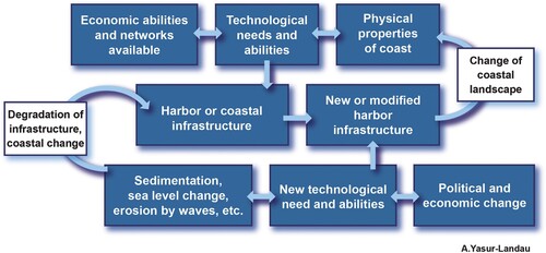
An example of the combined action of co-occurring environmental pressures and economic and political factors once a maritime infrastructure is built, can be seen in the series of harbours excavated at Burgaz/Old Knidos, in modern-day Türkiye (Greene et al., Citation2019). The process of silting, the expansion of the Classical city and the broadening of maritime networks resulted in the massive expansion of the existing harbour facilities in 400 BCE. In the Early Hellenistic Period (4th–3rd centuries BCE), the existing harbour facilities were no longer maintained, following a change in the political circumstances and the continuing silting. Instead, a new, massive infrastructure was built in a different location, away from the city centre (Greene et al., Citation2019, pp. 118–120). Similarly, throughout history, changing circumstances have affected decision-making processes also in the Carmel Coast settlements, resulting at times in the cessation of investment in the development of coastal infrastructure. Here we present a feedback model for diachronic changes in the adaptive use of anchorages along the Carmel Coast, in which political, economic and technological parameters join environmental variables (). Changes in each of the parameters – for example, the availability of new construction techniques, new ship types, gradual blocking of the basin by sediments or a rise in sea levels – would have required the port city or the polity to adapt in order to maintain its maritime connectivity or to change the nature of its maritime networks. Furthermore, this feedback mechanism can be used to understand adaptive cycles of a socio-ecological system facing either a specific crisis or co-occurring multiple pressure factors (Bradtmöller et al., Citation2017; Menegat, Citation2022).
Figure 1. Simplified feedback model for diachronic changes in the adaptive use of anchorages suggested for this study (prepared by A. Yasur-Landau).
The Missing Maritime Infrastructure of Hellenistic and Roman Dor
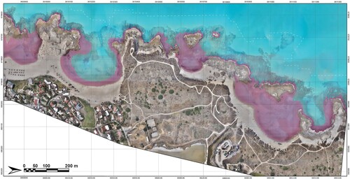
Dor, the focus of this study, is an ancient coastal tell (artificial mound) located 21 km south of Haifa and 13 km north of Caesarea, Israel. The site has four bays, from south to north: Dor/Tantura Lagoon, South Bay, Love Bay and North Bay (). Initially settled at the end of Neolithic Period (Shtienberg et al., Citation2020), it was only in the 2nd millennium BCE that an extensive period of uninterrupted habitation began at Dor that would be maintained for 2300 years: from its first large-scale settlements in the Middle and Late Bronze Ages (ca. 2000–1200 BCE), through the Iron Age (ca. 1200–550 BCE), the Persian (ca. 550–330 BCE) and Hellenistic (ca. 330–40 BCE) Periods, up to at least the Late Roman Period (3rd–4th centuries CE), with ample evidence of maritime connectivity (Gilboa et al., Citation2008; Nitschke et al., Citation2011; Stern, Citation1994).
Figure 2. Tel Dor, its bays and location of main features mentioned in this article: (1) Tantura Lagoon; (2) South Bay; (3) Love Bay; (4) North Bay; (5) Tel Dor (note dashed line for the current boundaries of the Tel). Main features: (a) Area T, submerged Hellenistic fortification; (b) Tombolo, FDEM survey and possible tower; (c) Iron Age submerged fortification and mole; (d) Area D, Iron Age and Hellenistic structures; (e) Coastal Roman temples; (f) Slipways/shipsheds; (g) Love Bay underwater excavations; (h) Love Bay land excavations and Hellenistic structures; (i) North Bay Roman rectangular structure; (j) Area X, submerged Roman mole; (k) Area W, Roman and earlier anchorage (prepared by M. Runjajić, A. Tamberino and A. Yasur-Landau).

Despite our discovery of an 11th–7th-centuries BCE Iron Age harbour in South Bay of Dor and of evidence for Roman era activity in North Bay (Arkin Shalev, Gambash, et al., Citation2019; Arkin Shalev, Gilboa, et al., Citation2019), geophysical surveys of South Bay (Lazar et al., Citation2018, Citation2020), detailed geoarchaeological studies of the coastal sedimentary history of Dor (Shtienberg et al., Citation2021, Citation2022) and a comprehensive study of sea level changes between the Bronze Age and the Roman Period (Yasur-Landau et al., Citation2021), until recently, two main lacunae remained in the study of the maritime interface of Dor: the absence of either a Hellenistic or Roman harbour or coastal features at the site.
In the Hellenistic Period, Dor experienced an economic boom, reflected in well-built 3rd-century fortifications, rich private dwellings, an agora and a massive, monumental complex – possibly a duo of temples – overlooking South Bay. The extensive commercial contacts of the city are attested not only in the copious amounts of imported pottery, including wine amphoras (Rosenthal-Heginbottom, Citation1995; Stern, Citation1994, pp. 226–246) and finds from under water in most bays by the tell (Arkin Shalev, Gambash, et al., 2019, table 6), but also by the incorporation of Hellenistic art forms such as statuary and a mosaic (Nitschke et al., Citation2011, pp. 143–145). Leading into Love Bay from the south are three narrow 30 m long parallel rock-cut features that Raban referred to as ‘slipways’ and attributed to a ‘ship shed’ that was constructed in the 5th century BCE and went out of use in the Hellenistic Period (Baika, Citation2018, pp. 335–339; Raban, Citation1995, pp. 307–309). If this was indeed a ship shed, where are the harbour structures from this thriving Hellenistic city? Until recently, we found no evidence for these nor for any other coastal features, including fortifications, from this period.
The lack of Roman harbour infrastructure at Dor is also puzzling because coins minted at Dor during the reign of Trajan bear maritime symbols, as well as the prestigious title ‘Holy Dor, asylum, autonomous, ruler of the seas/fleet’, ΔΩP(A) IEP(A) ACYΛ(OC) AYTON(OMOC) NAYAPXIC (Meshorer, Citation1995). Is it likely that a city with no harbour would bear such a title? Indeed, the town plan of Dor in the Roman Period does not include a harbour (Nitschke et al., Citation2011, fig. 15). Roman Period remains indicative of maritime activity have been found under water in all of Dor’s bays, from Dor/Tantura Lagoon (including shipwrecks and cargoes), through South Bay and Love Bay and to North Bay (Arkin Shalev, Gambash, et al., Citation2019, table 6). We excavated a structure in North Bay that Raban suggested was a quay (Raban, Citation1995, pp. 294–295), and it was found to be a terrestrial structure, likely a paved street or road of the Roman Period. We concluded therefore that a pragmatic approach of the leaders of the polis of Dor led them to refrain from investing in a massive, costly and fragile maritime infrastructure (Arkin Shalev, Gambash, et al., Citation2019) of the type seen in Caesarea (Raban & Holum, Citation1996, pp. xxviii–xxxi). Rather, they used the existing bays for all their maritime needs, with a coastal administrative building overseeing the activity in North Bay – the Rectangular Structure, perhaps a storage facility (Raban, Citation1995, p. 290, fig. 9.9; Raban & Galili, Citation1985, p. 339).
Sea Level Changes from the Hellenistic to Roman Periods
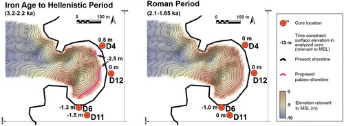
In Israel, the Holocene sea level reconstructions are especially robust for the last 2000 years, as data are abundant (see, e.g., Dean et al., Citation2019). Earlier studies, based on archaeological indications, included a limited number of indicators with large uncertainties for the period between 2000 and 100 BCE (Galili et al., Citation1988, Citation1993, Citation2019; Raban & Galili, Citation1985; Sivan et al., Citation2001.). In a recent article (Yasur-Landau et al., Citation2021) we addressed the lacuna in the study of relative sea levels (RSL) during this long time span, re-assessing previously published data from Dor as well as Yavneh Yam, ‘Akko and Caesarea, and incorporating significant new field data from archaeological sea level indications at Dor, primarily for the Iron Age, but also for the Hellenistic and Roman Periods. Most of the structures presented in the overall reconstruction are currently at or below sea level (BSL). Because the majority provide terrestrial limiting data, we concluded that the sea level position for 1800–200 BCE was 3.0–2.0 m BSL. Most significantly, the Hellenistic dataset indicates an abrupt sea level rise of ca. 2 m in the 200 years sometime before the Early Roman Period (Yasur-Landau et al., Citation2021, fig. 5). After this rise, excluding the Crusader Period, with an attested sea level drop of up to 50 ± 20 cm (Toker et al., Citation2012), sea levels remained mostly similar to current day levels, with fluctuations of a magnitude smaller than 0.2 m. Accordingly, this sea level change affected the seascape of Dor significantly, with a possibly devastating impact on Hellenistic coastal structures and society. Dor’s inhabitants in the Early Roman Period faced a reality in which two terrestrial areas were inundated: the vast area to the north of the tell turned into shallow North Bay, and the area to the west of the tell’s centre turned into shallow Love Bay. South Bay, to the south of the tell, grew deeper by up to 4 m, and larger in area by a third ( and ).
Figure 3. Map of the bays of Dor with purple contour line marking 2 m BSL points (prepared by A. Tamberino and M. Runjajić).
A Submerged Hellenistic Fortification Line in South Bay?
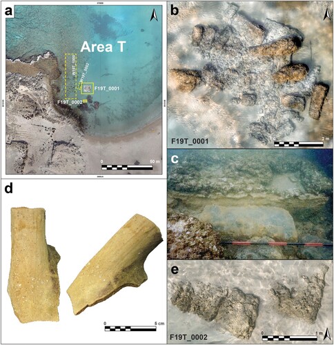
A series of submerged and buried features discovered in the southern part of South Bay, immediately north of a sandy isthmus or tombolo separating South Bay from the lagoon. These may be the remains of the Hellenistic fortifications that protected an anchorage in this bay and were impacted by sea level rise during the Roman Period. A 2018 underwater archaeological survey in this area (Area T) revealed a structure made of large ashlar stones. Following this discovery, a 2019 underwater excavation to the east and north of this structure indicated that it was part of a much larger artificial feature oriented north-east–south-west (F19T_0001; b). To date, an area of ca. 4 × 5 m has been excavated, which has not revealed the boundaries of the feature. It is composed of at least two courses of ashlar stones, the top one at a depth of 1.2–1.5 m BSL. The stones are of two sizes, with the larger measuring 1.45–1.50 m in length and 0.4–0.5 m in width, and the smaller, 0.95–1.00 m in length and 0.4 m in width. Several rectangular notches may be dowel holes cut into the stones. An E-shaped cut stone may have been the base for a wooden device, perhaps a winch (c). The few ceramic finds recovered include a handle of a basket-handled amphora (L19T_0007, B19T_0012; d), likely from Cyprus or the Aegean Islands, dating to the Persian or Hellenistic Periods. The stones rested on a dark clay sediment deposited during the Neolithic Period (see below). As the base of the structure is at a depth not sufficient for mooring boats even today, it is likely a submerged fortification, perhaps a tower, rather than a maritime structure. This feature is one in a series of submerged walls built of massive ashlars, identified during underwater and aerial surveys in Area T. Ten metres south of the excavation area, an additional wall, W19T_0002, composed of ashlar stones in articulation, may indicate a corner. The find that provides a context for all submerged structures near the tombolo is Wall W19T_1000 (), a monumental wall, 5 m wide, its visible extent measuring over 20 m. It is located 5 m west of the excavation square and continues north. Its dimensions, location and orientation indicate it may have been part of a fortification closing off South Bay from the south.
Figure 4. (a) Location map of Area T in South Bay; (b) Remains of Tower(?) F19T_0001 and wall F19T_1000; (c) Detail of E-shaped stone-cut feature in tower wall; (d) Basket-handled amphora sherd; (e) Wall (F19_0002) east of the tower (prepared by E. Arkin Shalev, A. Tamberino, M. Runjajić and J.J. Gottlieb).
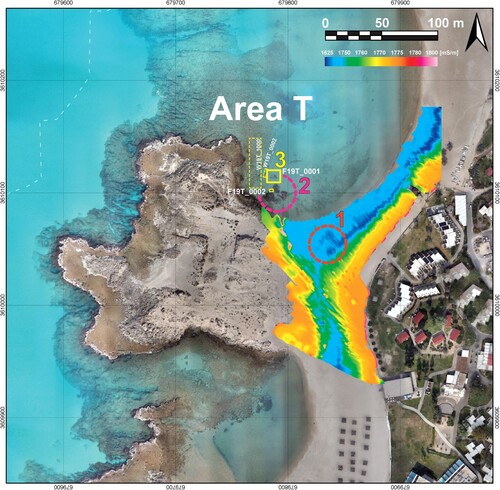
While our excavation is ongoing, some indications for the construction period may be ascertained already. The building technique of the walls is Hellenistic and can be dated even more precisely to the 3rd century BCE. The use of ashlar stones of two sizes, as well as the use of dry masonry, is similar to that in the construction of the Hellenistic fortifications on Tel Dor itself, just north of South Bay, and especially to that of the Hellenistic towers in Areas A and C, dated to the 3rd century BCE (Sharon, Citation1995, plans 5.11, 5.22, 5.31, photo 5.43). The use of ashlars and dry masonry in a marine context, with somewhat smaller stones, is seen in the Hellenistic harbour of ‘Akko, with its quays and ship shed dating to the 3rd century BCE (Sharvit et al., Citation2013). Iron Age harbour builders used large ashlars, as seen in the late Iron Age harbour of ‘Atlit, north of Dor (Haggi & Artzy, Citation2007; Yasur-Landau et al., Citation2018), though without a combined use of large and small ashlars. Furthermore, the stones used near the tombolo are considerably smaller than the same-sized ashlar blocks used in the Iron IB coastal fortifications in the northern part of South Bay (Arkin Shalev, Gambash, et al., Citation2019). A geophysical frequency domain electromagnetic (FDEM) survey of the coast to the east of the tombolo identified a large rectangular anomaly, parallel to the submerged structure that includes F19T_0001 and F19T_0002 (Lazar et al., Citation2020; ). This may be the buried remains of a tower, in the same line of the possible Hellenistic fortification line, blocking the land access to South Bay from the south.
Figure 5. Location map of FDEM survey and underwater remains related to possible Hellenistic fortification. (1) Possible tower under coastal sand, found in FDEM survey; (2) Possible submerged tower; and (3) Parts of fortification excavated and surveyed (prepared by A. Tamberino and M. Runjajić; geophysical data after Lazar et al., Citation2018).
Sedimentation in South Bay and the Impact of Sea Level Rise
Geoarchaeological studies of Dor's South Bay (Shtienberg et al., Citation2021, Citation2022) may provide some hints to the date of the end of the sea level rise in the vicinity of the proposed Hellenistic port. Core D6 from the northern edge of the tombolo () provided an OSL date of 1.8 ± 0.2 ka for the top of the aforementioned dark clay level at 1.5 m BSL (Shtienberg et al., Citation2022, fig. 9). This means that the surface of this clay unit was last exposed before being covered with pebble-abundant Nile-derived quartz sand (Shtienberg et al., Citation2020, supplement 2) during the Roman Period. No deposits with Hellenistic or earlier dates were found below it, likely indicating that sea activity during the period of heightened sea level rise eroded them all the way down to the Neolithic deposits, as indicated by a 9.8 ± 0.8 ka age from the same core, at 2 m BSL.
Figure 6. The locations of the cores and diagram of the chrono-stratigraphy of the coast of Dor, including Core D. The OSL dates of the sediments in each core were used to reconstructs coastlines in the Hellenistic and Roman Periods (). (Kadosh et al., Citation2004) and Cores D8, D11, D6, D12 and D4 (Shtienberg et al., Citation2021) (prepared by G. Shtienberg, A. Tamberino and M. Runjajić).
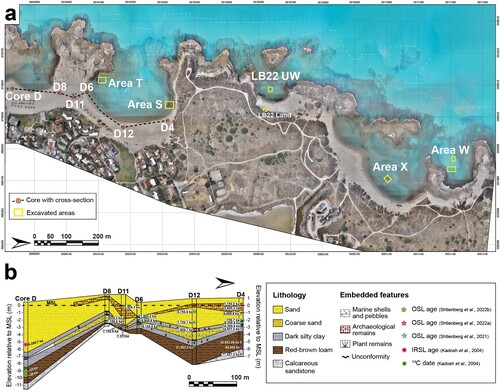
Core D11, drilled 80 m south of Core D6 (), in an inner, more protected area of the tombolo, produced an age of 2.5 ± 0.3 ka in a deposit of shell-abundant quartz sand in an elevation of the current sea level (Shtienberg et al., Citation2022, fig. 9), indicating that this poorly sorted marine sand unit was deposited between the end of the Iron Age and the Hellenistic Period. Thanks to its protected location, it was not disturbed during the sea level rise in the Roman Period (Shtienberg et al., Citation2022, fig. 9). The age and elevation of the deposit relative to palaeo-sea level (Sivan et al., Citation2004; Yasur-Landau et al., Citation2021) also indicate that there was no available sailing channel east of the tombolo, leading from the Dor/Tantura Lagoon into South Bay. Further possible evidence for an erosion of sediment post-dating the Iron Age comes from Core D4 (), located in the north-eastern part of South Bay, on the ancient coast, to the east of the Iron Age port. There, an age of 2.8 ± 0.3 ka at 0.3 m BSL in a sand layer may indicate the end of the use of the Iron Age port. It is topped not by a Hellenistic layer, but by a sand layer dating to the Middle Ages, with an age of 1.1 ± 0.2 ka at an elevation of 0.3 m above sea level (ASL). This may represent a period of lower sea level during the Middle Ages, which would have enabled sedimentation, following a higher sea level in the Roman and Byzantine Periods (Toker et al., Citation2012). The combined data from these cores and the marine sand layer identified in them, as well as sea level proxies from the Iron Age, may help reconstruct a ‘before and after’ picture of South Bay at Dor demonstrating a post-Iron Age sea level rise, from the Late Hellenistic to the Early Roman Periods, the deeper parts of South Bay becoming up to 4.5 m deep ( and ).
Figure 7. Time-constraint surface maps of the shallow marine-terrestrial coastal area of Dor and shoreline location changes during the Hellenistic and Roman Periods. The red dots mark core locations with their surface elevation relative to modern mean sea level for each time-constraint map (see also for the location of cores and OSL dates). The thick pink contour line marks the proposed shoreline location in the Iron Age and Hellenistic Period (prepared by G. Shtienberg, A. Tamberino and M. Runjajić).
Underwater Excavations at Love Bay and the Question of the Slipways
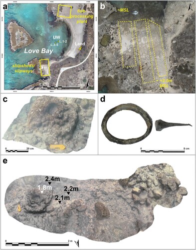
Underwater excavations undertaken in 2022 in the centre of Love Bay have confirmed the suggestion of previous surveys conducted since 2013 regarding the shallow nature of this bay, and demonstrated that the bay’s depth does not exceed 2–2.4 m. A large sub-rectangular perforated mooring stone, ca. 0.7 × 0.8 m in size, was located at the centre of the bay, in its deepest part. Near the mooring stone were numerous stones, ca. 20 cm in diameter, possibly a concentration of ballast stones (c, ). A 3 × 10 m trench (b) was excavated near the mooring stone, revealing alternating layers of round stones (ballast?) and shells at 2.0–2.4 m BSL (L.1, L.2). A second 3 × 10 m trench was opened 13 m to the west, in what was thought to be the deepest part of the bay and excavated from 1.9 m to 2.4 m BSL (L.3–5), down to bedrock. Two lead finds were recovered, connected with maritime activity (d): a sail ring (L.4) and a nail (L.5). The discovery of bedrock indicated that the area could not have been used as an anchorage during the Hellenistic Period or earlier. Rather, it was only in the Roman Period that the bay was inundated, and its water depth enabled mooring of boats. This observation raises the question of the ship sheds/slipways south of Love Bay. Raban interpreted these three parallel rock-cut features – 30 m long, 3.8–4.5 m wide and divided by partition walls ca. 1.5 m high and 0.6–0.8 m thick – as 5th-century BCE slipways or ship sheds, based on their typology (Baika, Citation2018, pp. 335–339; Raban, Citation1995, p. 307). In the absence of direct means of dating, Yasur-Landau et al. (Citation2018, p. 47) suggested that these features were closely related to the intense building activity in the Roman temples to their south, facilitating the transportation of building material for their construction from the sea to the construction site. When these temples were built, in the second half of the 2nd century CE (Nitschke et al., Citation2011, pp. 146–147), the sea level had already stabilised approximately at its current level, as indicated by archaeological sea level proxies from wells in Caesarea (Dean et al., Citation2019) and a fishpond or fish-processing plant at Dor (Yasur-Landau et al., Citation2021, table 1). Therefore, the construction and use time of these slipways likely dates to the Roman Period, in which they faced a water-filled bay, rather than to the Hellenistic Period or earlier, when Love Bay did not yet exist.
Figure 8. (a) General view of remains in the Love Bay mentioned in the text; (b) Aerial and land view of the ship sheds/slipways; (c) Underwater excavations showing mooring stone; (d) Finds from the underwater excavation; (e) Mooring stone and associated ballast stones (prepared by A. Tamberino, M. Runjajić and J. Gottlieb).
Evidence from Love Bay of the Impact of Sea Level Rise
Evidence of a Hellenistic structure likely impacted by the sea level rise was found in the 2022 land excavations at Love Bay. Two adjoining walls, W22L.005 and W22L.006, creating a corner () were built of headers – a typical Hellenistic construction method known at Dor in other contexts as well (compare with Sharon, Citation1995, plan 5.22, wall 572). Wall 22L.006 was built on top of artificially flattened aeolianite bedrock. A deep rock cut feature, with straight edges and a corner was associated with the wall, contained within W22L.005 and W22L.006A. To understand the nature of the feature, we excavated a test trench to the north of the cut bedrock below W22L.006 (L22L.021 and L22L.28). The sediment, a mixture of sand and reddish silt with burnt patches, containing much pottery, was excavated to a level of 0.4 m ASL, where a layer of large stones was encountered. It is likely that the rock-cut feature continues farther down. The sediment containing Hellenistic pottery (no later pottery was found) may have been a deliberate fill laid in antiquity (). A single charcoal sample from L22L.021 (sample DLB-L21B81 analysed by the University of Georgia Center for Applied Isotope Studies, UGAMS#61052) provided an uncalibrated radiocarbon age of 2090 ± 20 BP. The 2 sigma (95.4% probability) calibrated age (using IntCal 20.14c; Reimer et al., Citation2020) is 166–46 BCE, a range well within the Late Hellenistic Period. With sea level rise in the Late Hellenistic Period, it is possible that this feature, either a rock-cut cellar or another semi-subterranean space, was inundated by both the sea and the coastal freshwater aquifer that ‘floats’ on top of the saline water (Shtienberg et al., Citation2022), suggesting the area was therefore backfilled with sediment from Hellenistic domestic dumps.
Figure 9. Land excavations in Love Bay and location of the Hellenistic walls and rock-cut feature (prepared by M. Runjajić and A. Yasur-Landau).
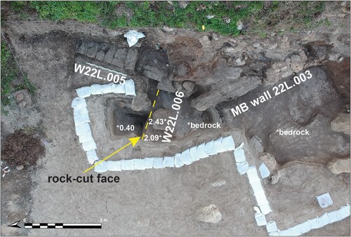
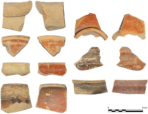
Figure 10. Land excavations in Love Bay; Hellenistic pottery from L22L.028 (prepared by Chandler Houghtalin, M. Runjajić and J. Gottlieb).
A Roman Maritime Structure in North Bay
Dor's North Bay has two areas (): its north-west is deeper, with a water depth of 4–6 m. Previous surveys by our team have located stone anchors and pottery from the Bronze Age and Iron Age to the Middle Ages. The south-eastern part of the bay (or the ‘small bay’) is shallow with a water depth of up to 2 m. Our surveys have discovered extensive evidence for maritime activity in the Roman and Byzantine Periods, including architectural elements such as column drums and marble fragments, deposited under water (Arkin Shalev, Gambash, et al., Citation2019). During May–June and November 2021, we excavated in both parts of North Bay.
Figure 11. Location of excavations in North Bay (aerial photograph by A. Tamberino, prepared by M. Runjajić).
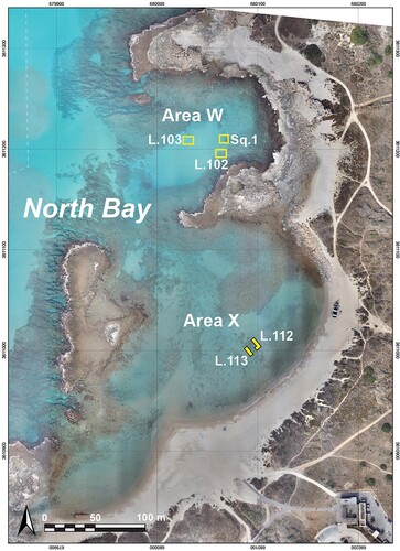
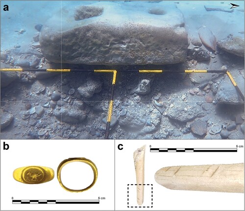
We excavated five 1 × 1 m squares in the north-western part (Area W), using a metal grid, adjacent to a stone anchor we identified previously in a survey conducted to understand the anchorage’s stratification (Arkin Shalev, Gambash, et al., Citation2019, fig. 13:4; Figures 11 and 12): one in square 1, one in L. 102 and three 1 × 1 squares in L. 103. In all squares the sedimentation included alternating layers of rounded stones and shells. In L. 103, with the lowest level of rounded stones and shells rested on a layer of greyish clay (top level of excavation 3.8 m BSL; bottom level 5.3 m BSL). These layers yielded a mixed pottery assemblage belonging mainly to the Hellenistic and Roman/Byzantine Periods. However, some finds from the Neolithic Period were also recovered, such as a sickle blade that had not been water worn, indicating the possibility of a Neolithic site in the area, predating the inundation and formation of a natural anchorage. This being the case, the alternating shell layers may represent natural deposits brought by currents and storms, between the anthropogenic deposits of the anchorage, represented by the rounded stones, likely ballast stones, as well as pottery. Evidence of the use of this anchorage in the Roman Period from L.103 (3.8–4.3 m BSL) includes cooking ware sherds with soot marks, as well as bones with cut-marks and a gold ring, possibly from the Roman Period (). The sherds and bones may be the remains of cooking activity on board of a boat moored in the bay. The ring had probably been lost by its owner.
Figure 12. Finds from the excavations of Area W in North Bay (all from L.103): (a) Stone anchor; (b) Gold ring; (c) Bone with cut-marks (prepared by J. Gottlieb).
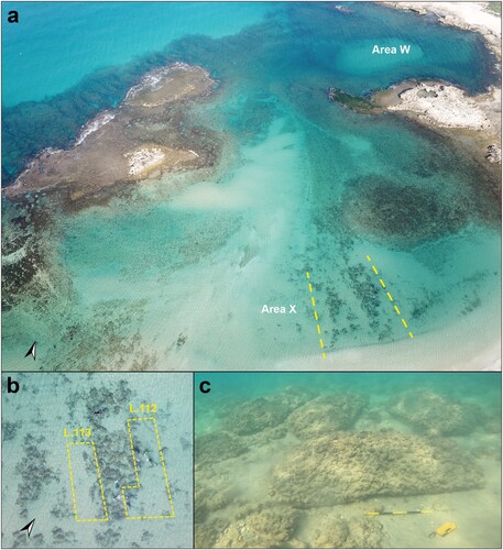
We opened a second area of excavation (Area X) in the southern part of North Bay, focusing on a large stone-built feature we discovered in a survey. It is located ca. 30 m from the coast, at a bottom depth of ca. 2 m BSL, and is ca. 40 m long and 10 m wide, with a roughly east–west orientation (). The rectangular hewn stones that comprise this feature measure ca. 1.8 × 1.0 m. They are not arranged in rows or courses, but rather laid side by side, sometimes with 20–50 cm spaces between them. We began excavating adjacent to this feature’s northern face (L.112). The topmost sand layer was removed, revealing that the stones rested directly on the clay bed, and there were no indications for a barge, pointing to an intentional placement rather than a wreckage. A similar picture emerged when we excavated adjacent to the feature’s southern face. While only further excavations will enable to understand this feature fully, its overall layout is of a ca. 40 m long structure perpendicular to the coastline, indicative of a quay. The depth of 2 m and the lack of reefs in this area would have made it a safe docking location for ships during the Roman Period. Pottery recovered during this excavation and in a previous survey (Arkin Shalev, Gambash, et al., Citation2019) indicates intensive activity in the bay during the Roman Period, strengthening this suggestion. However, a built Roman harbour has not yet been identified in this bay. Nonetheless, the stone sizes are dissimilar to the much smaller ones used in the Hellenistic structures at Dor, and identical to the ones used in the construction of the Roman temples on Tel Dor (Nitschke et al., Citation2011, p. 149), as well as other Roman structures, such as the Rectangular Structure overlooking North Bay, both dating to the 2nd century CE (Raban, Citation1995, pp. 289–291). Thus, the rising water that filled the southern part of North Bay in the Late Hellenistic Period may have made it a well-protected shallow anchorage during the Roman Period, fit for barges and small boats. At the same time, the deeper, less protected small bay continued to be used. This reconstruction provides the first potential indication for a Roman pier, quay or dock of Tel Dor. The current finds are likely only the foundation of this structure, whose top stones were likely robbed during the time (Byzantine or post Byzantine era) when North Bay became a hub for shipping out building blocks removed from the tell (Gambash & Yasur-Landau, Citation2018).
Figure 13. Roman Period quay in North Bay (aerial photographs by A. Ben Zaken and A. Tamberino; underwater photograph by A. Yurman).
Environmental and Technological Feedback Mechanisms
The results of the coastal and underwater excavations, as well as geoarchaeological and geophysical studies in the bays of Dor, allow now to assess the environmental and technological aspects of the diachronic changes in the adaptive use of anchorages, according to the feedback mechanism presented in . Such an assessment is benefited from the study of Giaime et al. (Citation2019) on the impact of different forcing agents (floods, storms, sedimentary inputs, RSL changes, dredging and harbour structures) on the geomorphological evolution of harbour sites in deltaic environment during antiquity. This approach is also useful in assessing the change in the quality of each bay of Dor as an anchorage in the transition between the Hellenistic and Roman Periods. presents sedimentary inputs, storm impact and infrastructure in the different bays, as well as changes they underwent from Hellenistic to Roman times. It can be seen that while sedimentation is minimal, the main factors affecting the quality of the bays are sea level rise and resulting elevated exposure to storms. Furthermore, the factors of sea level rise and storm impact create their own feedback mechanism, as the first increases the negative impact of the second on maritime installation and the ability to anchor safely. Two pressure factors used by Giaime et al. (Citation2019) are likely to be minimal to negligible in the non-deltaic environment of Dor. Unlike in deltaic ports, flood impact is minimal in all of the bays, as there is no significant wadi or river issuing into them. As for the technological part of the adaptive feedback mechanisms, there is no evidence that the main Roman Period innovation in harbour construction, the use of hydraulic cement, was used in any of the maritime structures of Dor. Furthermore, it is also likely that due to the minimal sedimentation observed in each of the bays, no dredging effort was needed, and indeed, no signs of dredging were detected in any of the bays in the underwater excavations. Therefore, technological innovation does not seem to have been a key factor in the maritime adaptive cycle of Dor.
Table 1. Diachronic environmental pressure at the different bays of Dor.
We can see, through our new discoveries at Dor, that the residents of the city have with the new environmental reality. The maritime infrastructure of the Hellenistic Period of South Bay, which included a fortified anchorage or harbour, became less suitable for anchoring in the Roman Period due to sea level rise. South Bay was then supplemented with secondary shallow anchorages in North Bay and in Love Bay, both formed by the sea level rise, and both equipped with infrastructure designed to facilitate maritime activity. What remains to be evaluated is the input of the local and regional political factors into the adaptive feedback mechanism of loss of maritime infrastructure and the use of new anchorages ().
Conclusion
Dor: Maritime Resilience Lost and Gained
To complete our assessment of the way Dor adapted its maritime interface between the Hellenistic and Roman Periods, our finds on the coast and underwater should be contextualised together with local political and economic decisions reflected in monumental architecture of the city, as well as with wider political considerations attested in historical sources. The result is comprised in a narrative of an adaptive cycle of maritime resilience lost and gained.
The line of fortifications east of Dor was built in the 3rd century BCE (Stratum IVb; Stern, Citation1995, pp. 276–277), and we would therefore tentatively ascribe the newly discovered construction of the fortification line to the south of the South Bay, now underwater, to the same period. At first, in the 3rd and 2nd centuries BCE, the Hellenistic fortifications of Dor functioned well. They were strong enough to withstand the siege of Antiochus III in 219 BCE (Polybius, Historiae 5.66: Dahl, Citation1915, p. 65; Stern, Citation1994, p. 206; Stewart & Martin, Citation2003, p. 131). In the years 138–137 BCE, very likely still predating the beginning of the rapid sea level rise, the coastal fortifications of Dor seem to have been solid enough to withstand a massive land and sea siege by the joint forces of Antiochus VII and Simon against the usurper Tryphon (see also Gera, Citation1995, p. 493; Stern, Citation1994, p. 206):
And Antiochus encamped against Dor and with him were 120,000 warriors and 8000 horse. And he surrounded the city, and the ships joint the attack from the sea; and he worried the city by land and sea, and allowed no one to go out or in. … But Antiochus the King encamped against Dor on the second (day), continually bringing his forces up to it, and making engines of war, and he shut up Trypho so that he could neither go in nor go out. And Simon sent him 2000 picked men to fight with him; and silver and gold and many implements. (1 Maccabees 15:13–14, 25; Transl. Dahl, Citation1915, p. 67 see also Josephus, Antiquitates Judaicae 8.7.2)
The rise of the sea level and the loss of maritime infrastructure at Dor co-occurred with the expansion of the Hasmonean state and the conquest of Dor by Jannaeus in ca. 100 BCE (Stern, Citation1994, p. 260), and later with the incursion of Rome into the Hellenistic East in the 1st century BCE. A historical watershed event occurred in 64/3 BCE, when Pompey the Great tore the city of Dor from the Hasmonean Kingdom, made it an autonomous polis and annexed it to the province of Syria. This event was commemorated by the minting of coins with the inscription ‘year 1’, noting the re-foundation of the city, or at least a new count of years for it (Meshorer, Citation1995, p. 355; Stern, Citation1995, p. 261). To our mind, the reduced resilience of the city, caused by the sea level rise, would have diminished the city’s ability to object first to the Hasmonean conquest and then to Roman intervention.
The sea level rise in the 1st century BCE may have resulted in the lack of safe harbours available for mooring before Herod the Great began the construction of Caesarea in 22 BCE, on the likely destroyed remains of Straton’s Tower:
This city [Straton’s Tower] is situated in Phoenicia, on the sea-route to Egypt, between Joppa and Dora, which are lesser maritime cities, and not fit for havens, on account of the impetuous south-western winds that beat upon them, which rolling the sands that come from the sea against the shores, do not permit smooth landing; but the merchants are generally forced to ride unsteadily at their anchors in the sea itself. (Josephus, Antiquitates Judaicae 15.333)
It may have taken up to two centuries before Dor’s resilience was rehabilitated and before its residents began using the inundated areas as new, protected anchorages. For a long period of time, from the days of Vespasian and Titus to the reign of Trajan, Dor minted no coins (Meshorer, Citation1995, p. 359). Maritime themes related to Dor’s administration first appeared on a lead weight showing an oared galley, which bears the city name, Dora, and the year 162 to its 63 BCE foundation (100 CE; Meshorer, Citation1995; Stern, Citation1994, pp. 311–312). Maritime themes appeared also on coins when minting resumed under Trajan, with a massive issue of coins with these themes accompanied by the inscription ‘Ruler of the seas’, mentioned above, on an 111/12 CE coin (Meshorer, Citation1995, p. 359). Coin minting at Dor continued during the reigns of Hadrian and Antoninus Pius.
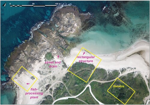
We may accredit the revival of Dor in the 2nd century CE to the support of Gargilius Antiquus, governor of Judea in 123–125 CE. Two different statue bases with dedicatory Greek inscriptions to this governor have been found at Dor, one by the eastern gate and the other, by our team, under water in North Bay (Gambash & Yasur-Landau, Citation2018). This is the only person thus honoured by the city of Dor in the Roman Period. The latter inscription reads: ‘(In honour of) Marcus Paccius, son of Publius … Silvanus Quintus Coredius Gallus Gargilius Antiquus, imperial governor with praetorian rank of the province of Judea and of Syria, the patron (a statue was erected)’ (Gambash & Yasur-Landau, Citation2018, p. 159). Calling Gargilius ‘the patron’ may indicate gratitude shown for his support in the turbulent years between the Jewish Diaspora Revolt and the Bar-Kokhba Revolt (Gambash & Yasur-Landau, Citation2018, p. 164). The findspot of the inscribed statue base, in the shallow part of North Bay, may hint at its possible original location near the 2nd-century CE administrative building – the Great Rectangular Structure, built just west of the Roman theatre (Arkin Shalev, Gambash, et al., Citation2019; Raban, Citation1995, p. 290; ). We suggest that the quay in North Bay could have been in use already during this phase, enabling the moving of stones from coastal quarries to the north of Dor for the building projects in North Bay and its environs. These included the above-mentioned administrative structure, a street and a drainage channel running towards the coast (Arkin Shalev, Gambash, et al., Citation2019, figs 3, 4) and an industrial area, including the main phase of the ‘purple dye factory’ (actually a fish processing plant; Raban, Citation1995, pp. 296–301). Stones of similar size were used for the construction of the Roman theatre, immediately south-east of North Bay (Stern, Citation1994, pp. 295–296).
Figure 14. Roman structures in the southern part of North Bay (aerial photograph by A. Ben Zaken; data by A. Yasur-Landau).
Dor’s maritime recovery continued later in the 2nd century CE. The construction of the gargantuan temples in the second half of the same century was clearly related to the efforts of Dor to reconnect to maritime activity, visible on its coinage:
Visibility to passing ships was perhaps a key component in deciding to install these precincts in this location, at the expense of the sea-view houses already in place. (Nitschke et al., Citation2011, p. 150)
The renewed maritime prosperity of Dor may have been short-lived. This is reflected also in the city’s coins, the last of which, still bearing maritime symbols, were minted no later than the reign of Septimius Severus and Julia Domna (211–212 CE) (Meshorer, Citation1995, pp. 359–360; Stern, Citation1994, p. 266). By the 3rd century CE, no new structures were being built on the tell, and coins post-dating the reign of Severus Alexander (222–235 CE) are rare (Nitschke et al., Citation2011, p. 152). In the 4th century CE, Eusebius noted that the city lay in ruins (Onomasticon 376; Gambash, Citation2015; Stern, Citation1994, p. 263).
Permission Statement
The 2018 underwater archaeological survey in Area T was carried out under IAA Underwater Survey Permit no. S828/2018 (permit holders: A. Yasur-Landau and A. Gilboa; area supervisor: E. Arkin Shalev). The subsequent underwater excavation in 12–21 February 2019 was conducted under IAA Permit no. G-14/2019 as a study excavation of the Department of Maritime Civilizations. A. Yasur-Landau (permit holder) and T. E. Levy directed it, with E. Arkin Shalev as Field Director.
Underwater and land excavations were carried out simultaneously in the centre of Love Bay in 2–14 February 2022 (IAA Permit no. G-12/2022 and IAA Permit no. G-14/22, respectively) as part of the study excavation of the Department of Maritime Civilizations, Haifa School of Archaeology and Maritime Cultures. R. Shahack-Gross (permit holder) directed the land excavations, with the assistance of C. Houghtalin (Area Supervisor), while A. Yasur-Landau directed the underwater excavations with the assistance of Silvana Kreins and Marko Runjajić.
The excavation of North Bay in 25 May–1 June and 7–18 November 2021 was conducted under IAA Permit no. G-6/2021 and was directed by A. Yasur-Landau (permit holder) and T. E. Levy, with R. Nickelsberg as Field Director.
Acknowledgments and Funding
The new data from the environs of Tel Dor presented here are a research product of the underwater excavations and coastal surveys directed by A. Yasur-Landau and T. E. Levy (in 2018–22), as part of a collaboration between the Tel Dor Underwater Excavations Project of the University of California, San Diego, and the University of Haifa Koret Foundation as well as a part of the Tel Dor Joint Expedition; and by a land excavation directed by R. Shahack-Gross (in 2022). We are grateful to the RIMS Maritime Workshop, headed by A. Yurman and M. Bachar. We would like to express our gratitude to the National Parks Authority and to Y. Uzan, site manager of Tel Dor National Park, for his extensive ongoing cooperation and assistance, and to Y. Bordowitz for facilitating the permit process. We would like to thank additional members of the underwater team: T. Sokolsky (registrar and lab director), A. Pietraszek and S. Kreines (shift supervisors), S. McAvoy, L. Clark and J. Reese (mapping and modelling by UCSD). This study was financed by a Koret Foundation grant (Grant ID, 190295 P.I. T. E. Levy) and grants from the Israel Science Foundation (Grant ID 495/18 P.I. A. Yasur-Landau for the Maritime Interface in the Bronze and Iron Ages: An Underwater Study of Tel Dor Anchorages and Harbor Infrastructure Project; Grant ID 697/20 P.I. R. Shahack-Gross).
Disclosure statement
No potential conflict of interest was reported by the author(s).
Additional information
Notes on contributors
Assaf Yasur-Landau
AYL: Conception, general project design, supervision of data acquisition, analysis and interpretation, writing, acquisition of funding.
Anthony Tamberino
AT: data acquisition underwater and on land, writing.
Ehud Arkin Shalev
EAS: data acquisition underwater and on land, writing.
Roey Nickelsberg
RN: data acquisition underwater and on land, writing.
Marko Runjajić
MR: data acquisition underwater and on land, writing.
Gilad Shtienberg
GS: Analysis and interpretation (geoarchaeology), writing
Gil Gambash
GG: Analysis and interpretation (historical sources), writing
Ruth Shahack-Gross
RSG: Data acquisition of Love Bay land excavation, writing, acquisition of funding.
Thomas E. Levy
TEL: Conception, general design, supervision of data acquisition, analysis and interpretation, writing, acquisition of funding.
References
- Arkin Shalev, E., Gambash, G., & Yasur-Landau, A. (2019). Disheveled tenacity: The North Bay of Roman and Byzantine Dor. Journal of Maritime Archaeology, 14, 205–237. https://doi.org/10.1007/s11457-019-09235-y
- Arkin Shalev, E., Gilboa, A., & Yasur-Landau, A. (2019). The Iron Age maritime interface at the South Bay of Tel Dor: Results from the 2016 and 2017 excavation seasons. International Journal of Nautical Archaeology, 48(2), 439–452. https://doi.org/10.1111/1095-9270.12360
- Arnaud, P. (2015). The interplay between practitioners and decision-makers for the selection, organisation, utilisation and maintenance of ports in the Roman Empire, In J. Preiser-Kapeller, & F. Daim (Eds.), Harbours and maritime networks and complex adaptive systems (pp. 61-82). Schnell & Steiner.
- Baika, K. (2018). Dor. In D. Blackman, B. Rankov, K. Baika, H. Gerding, & J. Pakkanen. Shipsheds of the ancient Mediterranean (pp. 335–339). Cambridge University Press.
- Bradtmöller, M., Grimm, S., & Riel-Salvatore, J. (2017). Resilience theory in archaeological practice – An annotated review. Quaternary International, 446, 3–16.
- Christodoulou, A., Christidis, P., & Demirel, H. (2019). Sea – level rise in ports: A wider focus on impacts. Maritime Economics & Logistics, 21, 482–496. https://doi.org/10.1057/s41278-018-0114-z
- Dahl, G. 1915. The materials for the history of Dor. Transactions of the Connecticut Academy of Arts and Sciences, 20, 1–181. https://doi.org/10.1016/j.quaint.2016.10.002
- Dean, S., Horton, B. P., Evelpidou, N., Cahill, N., Spada, G., & Sivan, D. (2019). Can we detect centennial sea-level variations over the last three thousand years in Israeli archaeological records? Quaternary Science Reviews, 210, 125–135. https://doi.org/10.1016/j.quascirev.2019.02.021
- Galili, E., Benjamin, J., Eshed, V., Rosen, B., McCarthy, J., & Kolska Horwitz, L. (2019). A submerged 7000-year-old village and seawall demonstrate earliest known coastal defence against sea-level rise. PLoS One, 14(12), e0222560. https://doi.org/10.1371/journal.pone.0222560
- Galili, E., Dahari, U., & Sharvit, J. (1993). Underwater surveys and rescue excavations along the Israeli coast. International Journal of Nautical Archaeology, 22(1), 61–77.
- Galili, E., Weinstein-Evron, M., & Ronen, A. (1988). Holocene sea-level changes based on submerged archaeological sites off the northern Carmel Coast in Israel. Quaternary Research, 29(1), 36–42. https://doi.org/10.1016/0033-5894(88)90069-5
- Gambash, G. (2015). Maritime activity in the ancient southern Levant – The case of late antique Dor. ARAM, 27, 61–74.
- Gambash, G., & Yasur-Landau, A. (2018). ‘Governor of Judea and Syria’. A new dedication from Dor to Gargilius Antiquus. Zeitschrift für Papyrologie und Epigraphik, 205, 158–164.
- Gera, D. (1995). Tryphon’s sling bullet from Dor. In E. Stern, J. Berg, A. Gilboa, B. Guz-Zilberstein, A. Raban, R. Rosenthal-Heginbottom, & I. Sharon, Excavations at Dor, final report: Vol. 1B. Areas A and C: The finds (pp. 491–496). Institute of Archaeology, Hebrew University of Jerusalem.
- Giaime, M. Marriner, N. & Morhange, C. (2019). Evolution of ancient harbours in deltaic contexts: A geoarchaeological typology. Earth Science Reviews, 191, 141–167.
- Gilboa, A., Sharon, I., Raban-Gerstel, N., Shahack-Gross, R., Karasik, A., & Eliyahu-Behar, A. (2008). Between the Carmel and the sea: Tel Dor’s Iron Age reconsidered. Near Eastern Archaeology, 71, 146–171.
- Greene, E. S., Leidwanger, J., & Tuna, N. (2019). Archaeological investigations in the harbours of Burgaz, Turkey: 2011–2015 field seasons. International Journal of Nautical Archaeology, 48(1), 103–122. https://doi.org/10.1111/1095-9270.12334
- Haggi, A., & Artzy, M. (2007). The harbor of Atlit in northern Canaanite/Phoenician context. Near Eastern Archaeology, 70, 75–84.
- Kadosh, D., Sivan, D., Kutiel, H., & Weinstein-Evron, M. (2004). A late Quaternary paleoenvironmental sequence from Dor, Carmel coastal plain, Israel. Palynology, 28, 143–157.
- Lazar, M., Engolz, K., Basson, U., & Yasur-Landau, A. (2018). Water saturated sand and a shallow bay: Combining coastal geophysics and underwater archaeology in the South Bay of Tel Dor. Quaternary International, 473, 112–119.
- Lazar, M., Himmelstein, A., Levy, T. E., Arkin Shalev, E., Basson, U., & Yasur-Landau, A. (2020). The door to Dor: Tracing unseen anthropogenic impact in an ancient port. Georachaeology, 36(2), 202–212. https://doi.org/10.1002/gea.21825
- Leidwanger, J., (2013). Opportunistic ports and spaces of exchange in Late Roman Cyprus, Journal of Maritime Archaeology, 8, 221-243
- Marriner, N., Morhange, C., Kaniewski, D., & Carayon, N. (2014). Ancient harbour infrastructure in the Levant: Tracking the birth and rise of new forms of anthropogenic pressure. Scientific Reports, 4, 5554. https://www.nature.com/articles/srep05554
- Menegat, S. (2022). From panarchy to world-ecology: Combining the adaptive cycle heuristic with historical-geographical approaches to explore socio-ecological systems’ sustainability. Sustainability, 14(22), 14813. https://doi.org/10.3390/su142214813
- Meshorer, Y. (1995). The coins from of Dora. In E. Stern, J. Berg, A. Gilboa, B. Guz-Zilberstein, A. Raban, R. Rosenthal-Heginbottom, & I. Sharon, Excavations at Dor, final report: Vol. 1A: Areas A and C: Introduction and stratigraphy (pp. 355–365). Institute of Archaeology, Hebrew University of Jerusalem.
- Nakas, I., (2022). The Hellenistic and Roman harbours of Delos and Kenchreai. Their construction, use and evolution. BAR International Series 3099, Nautical Archaeology Society Monograph Series 6). Oxford.
- Nitschke, J., Martin, R., & Shalev, Y. (2011). Between the Carmel and the sea: Tel Dor: The late periods. Near Eastern Archaeology, 74(3), 132–154.
- Portillo Juan, N., Negro Valdecantos, V., & del Campo, J. M. (2022). Review of the impacts of climate change on ports and harbours and their adaptation in Spain. Sustainability, 14(12), 7507. https://doi.org/10.3390/su14127507
- Preiser-Kapeller, J. (2015). Harbours and maritime networks as complex adaptive systems – A thematic introduction. In J. Preiser-Kapeller, & F. Daim (Eds.), Harbours and maritime networks and complex adaptive systems (pp. 1–24). Schnell & Steiner.
- Raban, A. (1995). Dor-Yam: Maritime and coastal installations at Dor in their geomorphological and stratigraphic context. In E. Stern, J. Berg, A. Gilboa, B. Guz-Zilberstein, A. Raban, R. Rosenthal-Heginbottom, & I. Sharon, Excavations at Dor, final report: Vol. 1A: Areas A and C: Introduction and stratigraphy (pp. 286–354). Institute of Archaeology, Hebrew University of Jerusalem.
- Raban, A., & Galili, E. (1985). Recent maritime archaeological research in Israel: A preliminary report. International Journal of Nautical Archaeology, 14(4), 321–356. https://doi.org/10.1111/j.1095-9270.1985.tb00536.x
- Raban, A., & Holum, K. (1996). Introduction. In A. Raban, & K. Holum (Eds.), Caesarea Maritima: A retrospective after two millennia (pp. xxvii–xliv). Brill.
- Reimer, P.; Austin, W. E. N.; Bard, E.; Bayliss, A.; Blackwell, P. G.; Bronk Ramsey, C.; Butzin, M.; Edwards, R. L.; Friedrich, M.; Grootes P. M.;, et al. (2020). The IntCal20 Northern Hemisphere Radiocarbon Age Calibration Curve (0–55 cal kBP). Radiocarbon, 62(4). http://doi.org/10.1017/RDC.2020.41
- Rosenthal-Heginbottom, R. (1995). Imported Hellenistic and Roman pottery. In E. Stern, J. Berg, A. Gilboa, B. Guz-Zilberstein, A. Raban, R. Rosenthal-Heginbottom, & I. Sharon, Excavations at Dor, final report: Vol. 1B. Areas A and C: The finds (pp. 183–288). Institute of Archaeology, Hebrew University of Jerusalem.
- Sharon, I. (1995). The stratigraphy of Areas A and C. In E. Stern, J. Berg, A. Gilboa, B. Guz-Zilberstein, A. Raban, R. Rosenthal-Heginbottom, & I. Sharon, Excavations at Dor, final report: Vol. 1A: Areas A and C: Introduction and stratigraphy (pp. 49–234). Institute of Archaeology, Hebrew University of Jerusalem.
- Sharvit, J., Baxton, B., & Planer, D. (2013). Preliminary findings from archaeological excavations along the foot of the southern seawall at Akko, 2008–2012. Michmanim, 24, 39–52.
- Shtienberg, G., Cantu, K., Mischke, S., Sivan, D. Norris, R. D. Rittenour, T. M., Edelman-Furstenberg, Y., Yasur-Landau, A., Sisma-Ventura, G., & Levy T. E. (2022). Holocene sea-level rise and coastal aquifer interactions: Triggering mechanisms for environmental change and impacts on human settlement patterns at Dor, Israel. Quaternary Science Reviews, 294, 107740. https://doi.org/10.1016/j.quascirev.2022.107740
- Shtienberg, G., Gadol, O., Levy, T. E., Norris, R. D., Rittenour, T. M. Yasur-Landau, A., Tamberino, A., & Lazar, M. (2021). Changing environments and human interaction during the Pleistocene–early Holocene from the shallow coastal area of Dor, Israel. Quaternary Research, 105, 64–81. https://doi.org/10.1017/qua.2021.30
- Shtienberg, G., Yasur-Landau, A., Norris, R. D., Lazar, M., Rittenour, T. M., Tamberino, A., Gadol, O., Cantu, K., Arkin Shalev, E., Ward, S. N., & Levy, T. E. (2020). A Neolithic mega-tsunami event in the eastern Mediterranean: Prehistoric settlement vulnerability along the Carmel Coast, Israel. PLoS ONE, 15(2), e0243619. https://doi.org/10.1371/journal.pone.0243619
- Sivan, D., Eliyahu, D., & Raban, A. (2004). Late Pleistocene to Holocene wetlands now covered by sand, along the Carmel Coast of Israel, and their relation to human settlement – An example from the coastal site of Dor. Journal of Coastal Research, 20(4), 1035–1048.
- Sivan, D., Wdowinski, S., Lambeck, K., Galili, E., & Raban, A. (2001). Holocene sea-level changes along the Mediterranean coast of Israel, based on archaeological observations and numerical model. Palaeogeography, Palaeoclimatology, Palaeoecology, 167(1–2), 101–117. https://doi.org/10.1016/S0031-0182(00)00234-0
- Stern, E. (1994). Dor ruler of the seas: Twelve years of excavations at the Israelite-Phoenician harbor town on the Carmel Coast. Israel Exploration Society.
- Stern, E. (1995). Historical conclusions. In E. Stern, J. Berg, A. Gilboa, B. Guz-Zilberstein, A. Raban, R. Rosenthal-Heginbottom, & I. Sharon, Excavations at Dor, final report: Vol. 1A: Areas A and C: Introduction and stratigraphy (pp. 271–284). Institute of Archaeology, Hebrew University of Jerusalem.
- Stewart, A. F., & Martin. S. R. (2003). Hellenistic discoveries at Tel Dor, Israel. Hesperia, 72, 121–145.
- Toker, E., Sivan, D., Stern, E., Shirman, B., Tsimplis, M., & Spada, G. (2012). Evidence for centennial scale sea level variability during the Medieval Climate Optimum (Crusader period) in Israel, eastern Mediterranean. Earth and Planetary Science Letters, 315–316, 51–61. https://doi.org/10.1016/j.epsl.2011.07.019
- Yasur-Landau, A., Arkin Shalev, E., Zajak, P. R., & Gambash, G. (2018). Rethinking the anchorages and harbours of the southern Levant 2000 BC–600 AD. In C. von Carnap-Bornheim, F. Daim., P. Ettel, & U. Warnke (Eds.), Harbours as objects of interdisciplinary research: Archaeology + history + geosciences (pp. 73–89). Verlag des Römisch-Germanischen Zentralmuseums.
- Yasur-Landau, A., Shtienberg, G., Gambash, G., Spada, G., Melini, D., Arkin Shalev, E., Tamberino, A., Reese, J., Levy, T. E., & Sivan, D. (2021). New relative sea-level (RSL) indications from the eastern Mediterranean: Middle Bronze Age to the Roman Period (∼3800–1800 y BP) archaeological constructions at Dor, the Carmel Coast, Israel. PLoS ONE, 16(6), e0251870. https://doi.org/10.1371/journal.pone.0251870
- Zarmakoupi, M. (2018). The urban development of the late Hellenistic Delos. In Martin-McAuliffe, S.L.and D.M. Millette (Eds.), Ancient urban planning in the Mediterranean. New research directions (pp. 28–49). Routledge.