
ABSTRACT
This paper demonstrates that a shift from a purely technical to a more socio-technical perspective has significant implications for the conceptualization, design, and implementation of smart city technologies. Such implications are discussed and illustrated through the case of an emerging urban analytics tool, the City-scale Digital Twin. Based on interdisciplinary insights and a participatory knowledge co-production and tool co-development process, including both researchers and prospective users, we conclude that in order to move beyond a mere “hype technology,” City-Scale Digital Twins must reflect the specifics of the urban and socio-political context.
Introduction
How does a shift in focus from a purely technical towards a socio-technical perspective influence the design and implementation of smart city technologies? This is the central question we address through investigating the emerging concept of City-scale Digital Twins (CDTs) as digital representations of cities and the next generation of urban models. Using the case of a CDT prototype of the Cambridge city region in the United Kingdom, the study demonstrates how a two-pronged strategy combining social (urban governance) and technical (data and modeling) insights can support the conceptualization, design, and implementation of data-driven solutions and digital tools within the broader urban “smartification” agenda.
Similarly to many other smart city technologies, the current discourse around digital twins – including their city-scale counterparts—is largely confined to a technology-centric view with a main purpose of demonstrating technical functionality. CDTs may in fact offer certain benefits—for example, in terms of contributing to achieving urban sustainability goals through providing improved insights for more effective and efficient city planning and management. However, based on the current technology-driven perspective on digital twins focusing on real-time sensory data, big data analytics, 3D visualization, and automation (see, for example, cityzenith.com/smartworldpro/digital-twin-solutions), it remains unclear how exactly these proposed benefits will be delivered and sustained.
Building on the literature that views smart city development through the lenses of socio-technical innovation and transitions (Carvalho, Citation2015; Mora and Deakin, Citation2019; Kitchin Citation2015), we propose that the realization of such benefits is not “automatic” or “natural” especially considering the origins of digital twins. Instead, conceptualizing what digital twins of cities could and should represent, and how, requires interdisciplinary insights and deliberative and participative processes that involve “prospective users” (i.e., those planning and managing cities and those living and working in them) in addition to researchers and technology suppliers (Ku and Kwok, Citation2015). Such insights can (and should) in turn be used to shape the emerging concept of CDTs, in order to ensure meaningful contribution to policy and practice and increase the chance of successful implementation. This interdisciplinary approach informed by a socio-technical perspective can also help move beyond the technology hype that currently surrounds the digital twin concept (Carvalho, Citation2015; Verbong et al., Citation2008).
The paper is structured as follows: the next section introduces the contemporary discourse on City-Scale Digital Twins and outlines the research agenda; that is followed by a discussion of the research design and methodology. Based on the analysis of the local governance context, the next section presents the social and organizational requirements for the Cambridge CDT tool; that is followed by a discussion of the technical design of the CDT and illustrates its use through a scenario drawn from the local air quality policy agenda (electrification of transport). Conclusions drawn from the Cambridge case, including reflections and suggestions for future research, are summarized in a final section.
Conceptualizing City-Scale Digital Twins
Definition and Research Agenda
City-Scale Digital Twins (CDTs) are digital representations, or “virtual replicas” of cities that can be used as simulation and management environments to develop scenarios in response to policy problems. In other words, CDTs are realistic digital representations of cities (including their assets, processes, and systems) that aid decision-making aimed at delivering city-level outcomes (urban planning, management, and associated services) and provide improved insights for decision-making (Bolton et al., Citation2018).
We argue that this definition is a good starting point for conceptualizing CDTs but that further refinement and scrutiny based on interdisciplinary insights from both the physical and social sciences is required. Of particular interest are the following interconnected issues:
unpacking the meaning and content of “realistic” digital representation
identifying which city-level decision-making processes can benefit from implementing CDTs and which cannot
in order to provide “improved insights” for decision-making, there is need to investigate the status quo.
Digital Twins of the Built Environment
Despite the current hype surrounding digital twin technologies, their core concept is not new. NASA experimented with digital replica-based simulation environments “mirroring” physical assets (space vehicles) as early as the 1960s. The term “digital twin” was coined more recently, in the context of Product Lifecycle Management in manufacturing (Grieves and Vickers, Citation2017). Today, the digital twin technology has become one of the prevailing buzzwords associated with Industry 4.0. However, despite the enthusiasm and high expectations attached to digital twins, a variety of issues remain insufficiently addressed in terms of data collection, processing, and modeling (Tao and Qi, Citation2019).
Following the influential “Data for the Public Good” report published by the National Infrastructure Commission in 2017, the potential of using digital twin technology in planning and managing the built environment has received much interest. The report calls for the development of a UK national infrastructure digital twin to enable better informed decision-making and improve the performance, quality of service, and value delivered by assets, processes, and systems in the built environment (NIC, Citation2017). In response, built environment digital twins have been defined as “realistic digital representations of physical things” (assets, systems, processes) that “unlock value by enabling improved insights that support better decisions” and “enable better use, operation, maintenance, planning and delivery of national and local assets, systems and services” (Bolton et al., Citation2018: 6).
The context for developing digital twins of the built environment, however, differs significantly from that of digital twins in manufacturing. First, much of the built environment data feeding digital twins are not readily available or producible due to dispersed asset and data ownership, a lack of data sharing frameworks, the commercial interests involved, and security and privacy concerns. There is also a lack of clarity in terms of viable value propositions that could facilitate and justify the required data collection, data sharing, and collaboration across multiple societal actors to realize the benefits offered by built environment digital twins. In addition, the role of people and social systems—e.g., in terms of treatment, representation, and involvement—is under-researched and under-conceptualized in the digital twin agenda focusing on the convergence of physical and digital systems (Tomko and Winter, Citation2019). Consequently, replicating the success of manufacturing digital twins in the context of the built environment is not straightforward.
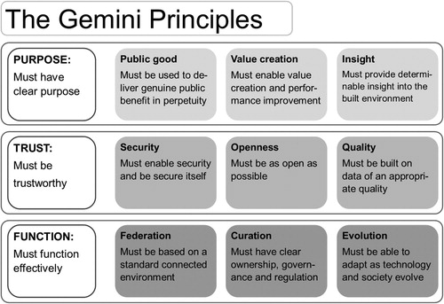
In a first step towards creating appropriate theories and frameworks to guide the application of the digital twin technology in the built environment, the Centre for Digital Built Britain’s Digital Framework Task Group devised a set of “Gemini Principles” (Bolton et al., Citation2018). Developed in support of the UK’s efforts to develop a national infrastructure digital twin, the Gemini Principles reject the option of a singular, centralized system. Instead, the vision promotes a federated system-of-systems approach (“ecosystem of digital twins”) in which the realism of the representation and the purpose it serves are interdependent. It also asserts that built environment digital twins must be developed based on nine principles centered on three key themes of purpose, trust, and function (See ).
Figure 1. The Gemini Principles for built environment digital twins. Source: Bolton et al., 2018.
Many cities around the world are also exploring the potential of using similar digital technologies in the planning and management of urban infrastructures and improving the delivery of associated services. Singapore has been developing a “Virtual Singapore” platform which features a three-dimensional model of the city’s built environment based on geospatial and geometrical data sourced from public agencies as well as infrastructure sensors (NRF, Citation2018). Virtual Singapore’s key function is to “help officials make the best urban planning decisions and communicate with citizens by sharing information visually” (Dassault Systèmes, Citation2018).
In the United Kingdom, notable examples of experimenting with City-Scale Digital Twins sprang out of the so-called “urban observatories” set up as part of the portfolio of the Collaboratorium for Research in Infrastructure and Cities (UKCRIC), for example in Newcastle-upon-Tyne (www.urbanobservatory.ac.uk); or the Here East Campus Digital Twin pilot (as part of the Queen Elizabeth Olympic Park Smart District) by University College London (Dawkins et al., Citation2018). Most of these initiatives have a common focus on exploring the usefulness of near-real-time sensory data and 3D visualization to support management (and to a lesser extent, planning) decisions. They, however, are limited either in terms of their spatial (UCL Here East) or systems (Newcastle) coverage. Singapore’s efforts to integrate city-scale data from a multiplicity of sources for simulation and city planning and management stand out—made possible largely by its unique city-state status.
This pioneering work has so far been mainly concerned with demonstrating the technical functionality of digital twin approaches to modeling, planning, and managing urban systems. Critical reflections on how these emerging digital tools are expected to contribute to delivering desired policy outcomes as part of comprehensive solution packages are still underdeveloped (Nochta et al., Citation2018). So are the roles of different societal actors, including local authorities, in developing (in terms of content and coverage) and operating (in terms of organizations and processes) CDTs.
Urban Modeling and City-Scale Digital Twins
CDTs represent a new wave of urban modeling tools aiming to inform city planning and management. However, urban simulation models aimed at informing policy and decision-making for sectoral infrastructure systems (e.g., transport) have been around since the 1960s (Lowry, Citation1964). Land-use and transport have traditionally been the main foci of applied urban modeling (Wegener, Citation1994, Citation2004). Over the past decades, significant research went into improving the operationality, comprehensiveness, and representativeness of urban models, informed by real-world applications of established models in various cities across the globe (Anas and Liu, Citation2007; Waddell, Citation2011; Jin et al., Citation2013; Wan and Jin, Citation2017). Applied urban models have played an important role in not only informing policy and interventions for cities and infrastructure, but also establishing a new science of cities through academic research (Batty, Citation2013).
The currently unfolding “Fourth Industrial Revolution” marks a major transition from a period of relative data scarcity to an era of digital abundance. It is at this point where traditional urban models and the concept of City-Scale Digital Twins (CDTs) become intertwined. On the one hand, the emerging data-driven approaches appear as distinct methodological deviation from theory-based conventional urban modeling. On the other hand, as new patterns are discovered using urban big data sets often based on associations rather than causality, theories about cities and human agents are needed more than ever in order to articulate such patterns and subsequently develop predictive capability—if possible at all—to inform practice (Batty, Citation2015). In parallel to the growing evidence base demonstrating the complementarity between big data and urban systems modeling (Wan et al. Citation2018), the consolidation of traditional approaches and the new data-driven methods calls for further research and interdisciplinary insights.
While technological advancement can make a substantial contribution to enhancing the representativeness and predictive capabilities of models in a techno-scientific sense, it does not guarantee a more successful utilization of model outputs as evidence in planning decision-making processes (Davoudi, Citation2006). The ways in which model outputs, and the policy recommendations based on them, are produced and used in complex decision-making processes involving multiple actors—each with different backgrounds, perceptions, and interests—are influenced by social and political questions. Such inherent complexities, however, often remain obscure for modelers. In turn, sociopolitical actors and processes are rarely addressed, at least not explicitly, in the technical design of conventional models. In turn, the lack of early-stage stakeholder consultation on model segmentations, assumptions, and scenario design may lead practitioners and other societal actors to question model outputs and recommendations.
At this stage of development, it is premature to claim that CDTs represent a paradigm shift in urban modeling. Batty (Citation2018) contends that the digital twin, as an exact mirror of the physical system eliminating the need for any abstractions, is distinct from conventional urban models in which abstraction remains a core element to enable the construction and operation of said models. Tomko and Winter (Citation2019) further argue that defining digital twins as digital replicas or mirror images of physical systems is simplistic and inherently ill-conceived. Instead, digital twins—of cities or the built environment—are better characterized as cyber-physical-social eco-systems, analogous to organisms “with a brain” (Tomko and Winter, Citation2019). This interpretation highlights the complexities of applying the digital twin concept to the built environment due to bi-directional coupling across the digital, physical, and social spheres.
This study, therefore, aims to move beyond the purely technical discourse that focuses exclusively on the convergence of the physical and digital spheres. We consider the development of CDTs as a socio-technical process driven by a need for a more strategic, policy-outcome orientation. Through the case of developing a CDT prototype for the Cambridge city region we present one option for, and demonstrate the viability of, such an approach—including the benefits it can offer for smart(er) digitalization in urban planning and management.
The Principles of a Socio-Technical Perspective on CDTs
As previously outlined, the interdisciplinary approach, informed by a socio-technical perspective, focuses not only on improving the quality of modeling evidence through more complete and dynamic representation but also on its usefulness and use in policy decision-making. The socio-technical perspective on developing CDTs, therefore, must emphasize the following aspects.
First, the need to go beyond demonstrating technical functionality to articulate aspects of purpose and trustworthiness (Bolton et al., 2018). The usefulness of CDTs in decision-making depends on the success of reframing of high-level policy goals into practical policy problems to which the model can suggest solution options. This reframing exercise must be informed by in-depth local knowledge and preferences and thus requires a participatory approach. Facilitating a more successful utilization of the model and its recommendations in this manner may also lead to improved use of evidence (including model outputs, as well as other types) in city planning and management.
Second, the technical design of the CDT must reflect specific characteristics of the local context (e.g., governance structures and processes) in order to facilitate successful implementation. While the technology-focused approach to CDTs often culminates in a vision of a centralized “single-source-of-truth” platform integrating data from various sources, several issues remain unaddressed. These include, for example, questions regarding the organizational setup required to operate, maintain, and update such a platform; the real-world viability of integrating it into currently existing governance systems; as well as the potential unintended consequences of doing so.
Third, the purely technology-focused approach overlooks the necessity and costs of individual (upskilling) and organizational (collaboration) learning required to adopt and integrate CDTs into policy decision-making structures and processes. Such costs (including both monetary and social) are expected to be covered by the prospective users (i.e., organizations, local actors, urban citizens) (for another example, see also Wiig, Citation2016). In contrast, we argue that such needs be incorporated into the design and implementation of CDTs. Also important is the consideration of skills and capability gaps, as input for educational outcomes, to enable a more meaningful digitalization as part of smart urban development.
In the remainder of this paper we explore the implications of these principles—which provide the framework for our socio-technical perspective—on the conceptualization, design, and implementation of CDTs.
Designing an Interdisciplinary, Socio-Technical Approach to CDTs
Adding the “Social” Element Through Participatory Case Study Research
This study contributes to addressing the following question: How does a shift in focus from a purely technical towards a socio-technical perspective influence the design and implementation of smart city technologies? In order to do so, we focus on the case of the emerging concept of City-Scale Digital Twins (CDTs). Based on a case study research design, we devised a participatory process for developing a CDT prototype for the Cambridge city region, involving a variety of prospective users. In the first instance, users were identified from different departments from various local public sector bodies. The aim of the participatory process was two-fold. First, to develop practice-informed evidence to influence and potentially redirect the development of the CDT concept. In other words, to “contextualize” CDTs and seek insights to refine the concept beyond the current technology-driven status quo. Second, to assess the potential and role of the CDT tool developed via participation in supporting public policy and decision-making in cities. The main focus of the participatory research was, therefore, co-producing knowledge (Campbell et al., Citation2016; Maiello et al., Citation2013) rather than enhancing research impact on practice (Darby, Citation2017). We acknowledge that this participatory approach also comes with certain limitations (Flinders et al., Citation2016; Polk, Citation2015), and, therefore, the insights developed through this study are most likely not exhaustive. Nevertheless, we contend that it represents a significant step towards a more democratic development and implementation of CDTs (and other digital simulation and management tools) within the broader smart city agenda.
The Participatory Research Methodology
The core of the participatory process for knowledge co-production and tool co-development consisted of three workshops held between December 2018 and July 2019. The workshops were organized jointly by the research group at the Centre for Smart Infrastructure and Construction and Cambridgeshire County Council’s Smart Cambridge team. Participants attending the workshops were recruited from the following local and regional public sector bodies: Cambridge City Council, Cambridgeshire County Council, Greater Cambridge Partnership, and Cambridge and Peterborough Combined Authority. They included representatives of different departments and units from built environment sectors such as spatial (land-use) planning, transport, energy, and air quality, in addition to the smart city team and the researchers. Workshops involved between 10 and 15 people, depending on participant availability.
The goal of Workshop 1, held on December 3, 2018, was to establish a purpose for the Cambridge CDT. Workshop 2, held on April 4, 2019, focused on exploring user requirements and collecting feedback on an initial prototype of the CDT model in a hands-on manner. Workshop 3, held on July 15, 2019, was dedicated to discussing the findings in terms of local organizational structural and procedural context and change drivers and constraints.
In addition to the workshops, the study also built on further secondary and primary data sources which provided input for the discussions and information on the broader context to interpret participant responses and workshop outcomes. These included local policy documents and municipal publications (purpose), a series of semi-structured interviews (social-organizational context), various publicly accessible open datasets (CDT prototype), as well as previous studies on transport and land-use modeling in Cambridge.
The Cambridge Case: A Purposeful CDT for the City Region
Cambridge is a historical university town located in the region of East Anglia in England, approximately 50 miles north of London. It is a relatively small city with an estimated population of just over 125,500 (Cambridgeshire Insight, Citation2018) of which about one fifth are university students. In addition to the universities (University of Cambridge, Anglia Ruskin University), the city region is also a global center of industry and associated research and development, in particular bioscience and information and communication technologies.
The initial screening of policy documents and municipal publications (Cambridge City Council, Citation2018; Cambridgeshire County Council, Citation2015; Cambridgeshire and Peterborough Combined Authority, Citation2017) highlighted a variety of challenges with a relevance to city planning and management in Cambridge. Of these, a key challenge of addressing four interconnected problems was deemed particularly pressing—and potentially inadequately handled—by the participants in Workshop 1: congestion, air pollution, housing shortage, and the limited capacity of the local energy infrastructure. The transport-related challenges of tackling congestion and improving air quality result in a knock-on effect on the electricity infrastructure due to the dominant strategy of electrifying transport to improve air quality. The limited capacity of the electricity grid, however, acts as a barrier to developing appropriate charging infrastructure. Furthermore, grid capacity also hinders new residential and commercial developments, with wide-ranging implications for the local economy. The discussion among workshop participants concluded that current and expected patterns of private car use is the key factor shaping the practical outcomes of policy and implementation (See ).
Figure 2. Purpose and framework for the Cambridge City-scale Digital Twin
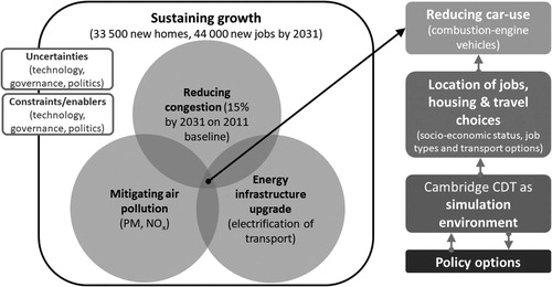
Local commitments exist to reduce car use by 10 to 15 percent between 2011 and 2031 (Greater Cambridge Partnership, Citation2018), while improving air quality and keeping pollutant concentrations (NOx and Particulate Matter) within the safety limits set by national policy. These improvements will need to take place against a projected 25.9 percent population growth in Cambridgeshire, and other economic and spatial development targets (Cambridgeshire Insight, Citation2015). Workshop participants highlighted that delivering on these targets will require additional support for coordination and joint working across various local government levels (city/district, county, metropolitan, national); the public sector and private sector actors (e.g., University of Cambridge, service providers, consultancies, employers), citizen activist groups (e.g., Smarter Cambridge Transport, CamCycle) and residents (e.g., Federation of Cambridge Residents’ Associations – FeCRA). This is important because strategic, tactical (long- and mid-term), and operational decision-making authority and responsibilities in the relevant infrastructure sectors and policy domains—including land-use, transport, energy, and air quality—are dispersed across different organizations.
Urban Governance and Its Implications for the Cambridge CDT
Research Agenda and Methods
CDTs, as virtual simulation and management environments, cannot “solve” contemporary urban challenges of growing population (and growing needs to be served), increasing spatial inequality, social exclusion, economic stagnation, and climate change mitigation and adaptation. That said, they can be designed and implemented in ways to contribute to capacity building in local governance systems for improved urban responses to such complex problems.
The participatory workshops helped to build a baseline understanding of the problems that are perceived as particularly pressing in Cambridge, including the associated shortcomings, limitations, and opportunities. In order to complement and validate the information collected via the workshops, an initial round of semi-structured interviews was organized with the workshop participants between December 2018 and April 2019. Further informants were identified via snowball technique, asking interviewees to identify other informants with diverse perspectives on, and roles in, decision-making processes relevant to the problem identified in Workshop 1. Snowball sampling was deemed to be the most appropriate to select informants in a context-sensitive manner who could be conceptualized as prospective users of the CDT model under development. Overall, 27 semi-structured interviews were conducted with officers at all four public sector bodies from the city region, employers, self-employed professionals, councilors, urban modelers, and community group representatives (residents’ associations, activist groups) (See ).
Table 1. Summary of the interviews conducted with local actors
The semi-structured interviews lasted between 45 and 90 minutes with only open-ended questions asked. Interviews were recorded and subsequently transcribed. Transcriptions were coded using specialized software, separately by the three researchers involved in the study. The findings were developed through comparing and discussing the individual results. This thematic analysis focused on mapping the societal actors, and their relations to one another, relevant to the identified problem situated at the nexus of specific policy domains (land-use, transport, energy, and air quality); the practices of using (modeling and other) evidence in the different organizations, units, departments, and citizen groups; and the influence of different types of evidence on their decisions, including but not limited to the recommendations based on data and modeling.
Findings: The Governance Context in Cambridge
The findings are summarized in terms of structural and procedural characteristics of local governance systems, and the role of (modeling and other) evidence within, in addressing the interconnected challenges of congestion, air pollution, growth management, and the limited capacity of the local energy infrastructure in the Cambridge city region. The term “governance” is used to denote the dispersed, multi-actor character of decision-making in public policy and implementation (Pierre, Citation2005; Meuleman, Citation2008).
The Structural Characteristics
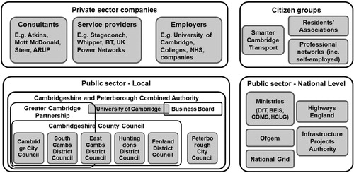
The analysis of structural characteristics of urban governance relevant to issues of congestion, air quality, energy supply, and growth management required the mapping of societal actors with an influence on decision-making processes in these domains (for a high-level overview see ). The mapping exercise revealed a high number of potentially relevant and influential societal actors from diverse backgrounds. It also highlighted the importance of considering the role of “siloedness,” and the impact of the fragmented organizational landscape, on developing urban responses to nexus problems.
Figure 3. Actor overview—Cambridge CDT ‘prospective users’
In public policy and administration, organizational fragmentation and its impacts are traditionally considered along two dimensions (Hooghe and Marks, Citation2001). First, vertically between different levels of government (e.g., sub-national, national, supra-national). Second, horizontally between different societal spheres (public, private, and third sector/community). Reduced coordination capacity to deal with complex problems that cut across institutional-organizational boundaries along these two dimensions is often cited as a key negative consequence of fragmentation (Skelcher, Citation2000; Pollitt and Bouckaert, Citation2011). In addition, interdisciplinary research and city planning and management practice also highlight problems caused by fragmentation across sectoral-systemic silos at the urban scale (Rogers, Citation2018). City systems (e.g., infrastructures and services) are typically vertically organized and function relatively autonomously. Coordination among them on the city scale is, therefore, inherently problematic. The results of the analysis of relevant structural characteristics of urban governance in Cambridge are presented in .
Table 2. Organizational fragmentation and siloed decision-making in Cambridge
The Procedural Characteristics
Fragmentation along the vertical, horizontal, and sectoral dimensions can have important implications for the use of evidence derived from modeling in policy-making and implementation in city planning and management. In the Cambridge case, such implications could be summarized in terms of trust (validity and transparency) and legitimacy (democratic quality and oversight). The associated problems in turn lead to confusion regarding the value of model outputs and recommendations as evidence for policy decision-making; city and infrastructure planning and management being driven by divergent political preferences at different government levels; and the lack of a comprehensive evidence-base constructively combining different types of data and knowledge (e.g., model outputs, citizen preferences, and feedback). The results of the analysis of relevant procedural characteristics of urban governance are presented in .
Table 3. The role of modeling evidence in policy decision-making
Implications for the Conceptualization, Design, and Implementation of the Cambridge CDT
The analysis of structural and procedural characteristics of local governance—relevant to issues of congestion, air quality, growth management, and energy supply—highlights a number of key considerations for the conceptualization, design, and implementation of CDTs. Despite having been derived from the perceptions of local societal actors in Cambridge, such considerations are likely to be relevant in many other cities with similar urban governance characteristics. Workshop 3 provided opportunity for discussing and validating the recommendations developed from Workshops 1 and 2, and the interviews (“participant validation”: Bryman, Citation2016).
The findings highlighted an apparent need for better collaboration and participation mechanisms across the city region’s fragmented governance landscape, informed by systemic interdependencies and pressing problems situated at the nexus of various policy domains. In the digital sphere, “black-box” modeling and a siloed evidence base also hinder the development of comprehensive responses to cross-cutting problems, and the negotiation of responsibilities and accountability relationships across a wider set of societal actors. While inherent problems with the centralization of powers, data, and responsibilities were cited by many interviewees, the need for developing ways to improve integration and interoperability across silos (e.g., through appropriately designed data sharing agreements) was also expressed.
Cambridge citizens do not reject evidence-informed policy-making and implementation as such: many respondents expressed a need for up-to-date, more accurate, and locally relevant databases to be developed, and stated that many of the emerging applications based on these data (e.g., developed by Smart Cambridge) are successful. However, with the continued and growing manifestation of economic development targets on citizens’ everyday lives, they require more and better options for public scrutiny. At present, citizens and community groups are faced with various difficulties in trying to engage with city planning and management processes. Developing inclusion strategies throughout the modeling process can, therefore, decrease re-planning costs and negotiation time and increase the perceived legitimacy of evidence derived from modeling exercises. It can also facilitate democratic debate and engagement and improved intermediation across various actor groups, within the public sector as well as among the public, market, and third sectors. Similarly, decreasing imbalances in terms of access to information, and increasing capability to make sense of it (upskilling), are equally important. User perspectives and requirements for the Cambridge CDT, developed through engagement with local societal actors, are summarized on .
Table 4. Overview of technical requirement for the Cambridge CDT according to local actors’ requirements
By addressing the requirements detailed in , the Cambridge CDT can help to improve policy decision-making at the nexus of the identified challenges. The specific requirements are as follows:
It should contribute to a more effective use of evidence in city planning and management through enabling a better understanding of cross-cutting problems and the communication of data-driven decisions.
For commissioning of modeling contracts to become more time and resource efficient, the CDT needs to support the development of modeling and sense-making capabilities both in-house (local authorities) as well as among urban citizens.
Broader accessibility improves the democratic quality of evidence-informed decision-making through enhancing transparency and accountability.
Developing a City-Scale Digital Twin for Cambridge
Research Agenda and Methods
The key methodological considerations for developing the CDT model for the Cambridge city region are based on outcomes of the participatory process and respond to the requirements derived from the analysis of local governance systems. The discussion of these methodological considerations is followed by a brief introduction of the modeling framework.
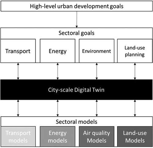
The first consideration pertains to the relationship between a CDT and existing urban models. A CDT is not a generic technology nor a singular modeling technique that can replace all existing modeling tools for the built environment. Instead, its role has been identified as one of coordinating across sectoral goals and policies and informing the use of sectoral models (See ).
Figure 4. Conceptualizing the relationship between the CDT and existing sectoral models
Conventional modeling evidence production for policy decision-making most often features long turnaround and siloed thinking (i.e., searching for solutions within sectoral limits, without addressing potential interdependence across sectors). This practice could be significantly improved by positioning the CDT in between policy decision-making and sectoral models. The CDT in this case could support the early stages of the policy decision-making process by:
helping to identify potential inconsistencies and conflicts between sectoral policies (e.g., electrification of transport to improve air quality versus limited capacity of the energy systems)
supporting interdisciplinary thinking in policy design
informing on where and when detailed modeling efforts are required, improving the efficiency and effectiveness of commissioning modeling exercises involving highly specialized yet resource-consuming sectoral models.
The second consideration regards the potential sources of data to develop the CDT. The primary focus of the CDT development at this pilot stage is to explore how existing data sourced from various sectoral silos could be connected to develop more comprehensive responses to the challenges of congestion, air quality, growth management, and energy supply. As such the development of the CDT prototype does not incorporate a large-scale data collection exercise but rather focuses on using readily available public data (e.g., UK Census series, Business Register and Employment Survey, Labor Force Survey, and open data from local governments). Insights from collating and analyzing existing data is expected to inform future data collection and data sharing initiatives. Importantly, it also alleviates the financial, technical, and administrative burden for developing the CDT prototype.
The third consideration relates to the spatial-temporal resolution of the CDT prototype. The participatory process revealed a need for multi-scale modeling, i.e., modeling apparatus with varying spatial-temporal resolution according to specific policy questions and goals. This is likely to be better achieved through linking models of different scales rather than developing a singular, scale-agnostic model of the whole built environment (i.e., following the “single-source-of-truth” approach currently favored by digital twin technology providers). In terms of temporal scale, the CDT prototype focuses on long-term strategic planning, as opposed to short-term operational management. At a first glance, the CDT prototype, with a strategic focus and using existing data, may appear significantly different from the mainstream interpretation of digital twins. The latter is typically seen as featuring (near-)real-time coupling between the digital and the physical system. Arguably, however, real-time is a relative term. The temporal scale of the CDT must reflect the rate of change in the subject system/process it aims to represent (Wan et al., Citation2019).
Based on the above considerations, the modeling framework of the Cambridge CDT prototype is presented in . The model prototype features a discrete choice model for simulating people’s choice on first, place of work (e.g., fixed workplace, mainly work at/from home, or no fixed workplace, based on the UK Census 2011 definition); and second, method of travel for commuting journeys. Both choice models are estimated using the 2011 Census Microdata (individual sample at local authority level) in STATA, using a multinomial logit model specification.Footnote1
Figure 5. Modeling framework for the Cambridge CDT prototype for journeys to work
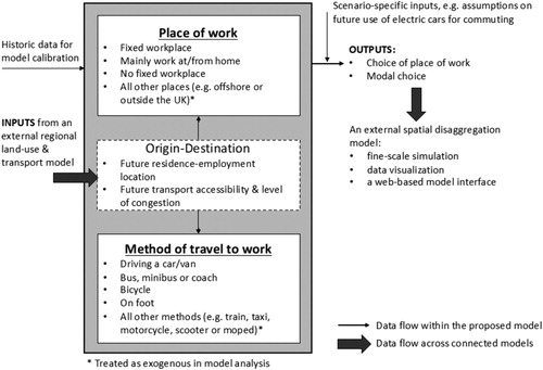
The CDT prototype is embedded into an existing suite of specialized models: It takes inputs from an external land-use and transport model developed for the Cambridge sub-region.Footnote2 Furthermore, it also provides the Middle layer Super Output Area (MSOA) level model outputs to another external spatial interaction model,Footnote3 which disaggregates the MSOA-level outputs to Lower layer Super Output Area (LSOA) level. This setup corresponds to the identified need for multi-scale modeling.
Cambridge CDT development
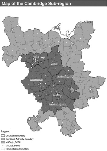
In the pilot stage of the CDT development process the core study area considered covers the Cambridgeshire and Peterborough Combined Authority (CPCA), which consists of six local authority districts (See ). Given the relatively large commuting catchment of Cambridge, the data collection and modeling area is expanded to cover the former Greater Cambridge and Greater Peterborough (GCGP) Local Enterprise Partnership area, which consists of 14 local authority districts.
Figure 6. Local and regional authorities in the Cambridge and Peterborough Combined Authority area
In order to demonstrate possible uses of the CDT model in real-world policy decision-making, we explored its potential to support scenario development and analysis for electrifying transport in the city region. This use case was chosen jointly by the participants of Workshop 2 (April 2019) due to the opportunity it offers to quantify the cross-sectoral linkages in local infrastructure planning.
Workshops and interviews with local authority representatives revealed that the promotion of shifting to electric vehicles (EVs) from traditional combustion-engines is considered as a major part of the local air quality policy agenda. However, the large-scale take-up of EVs is subject to the capacity of local electricity grid. In the Cambridge city region, the electricity infrastructure is already under considerable strain—highlighting the need for considering interdependencies among sectoral and local policies and interventions.
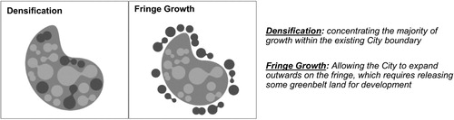
The modeling exercise started with the assumption that all vehicles commuting to Cambridge, including those commuting within Cambridge, will be EVs. From the perspective of the local policy agenda for improving air quality this can be considered as the best-case (although utopian) scenario. To simplify the energy simulation, we did not differentiate the types of EVs and assumed a uniform electricity consumption per km travelled by EVs (0.151 kWh per km; ref: A1.3.8 in DfT [Citation2018]). Neither was the electricity charging demand for non-commuting use of EVs considered. A key variable relevant to policy decision-making is the spatial distribution of future housing and employment growth in the study region (See ). Two alternative spatial development strategies were tested, which are in line with the scenarios presented in the recent Cambridge and Peterborough Independent Economic Review report: Densification and Fringe Growth (CPIER, Citation2018). The Cambridge CDT prototype predicts how alternative spatial strategies may affect the distribution of EV charging demand across the study area.
Figure 7. EV charging scenario: Alternative spatial development strategies for Cambridge and the environs
Model outputs are presented in and . To highlight the potential impacts of a more proactive approach from local and regional authorities (e.g., based on incentives or regulation), two variations are considered. The first assumes that all commuting EVs charge exclusively at work locations (left diagram in ) and the other assumes a home-charging only scenario (right diagram in ).
Figure 8. Model output of EV charging scenario I: Densification
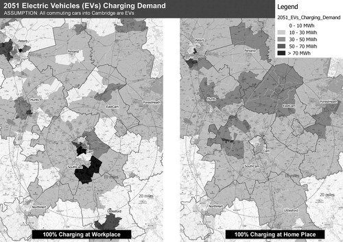
Figure 9. Model output of EV charging scenario II: Urban Fringe
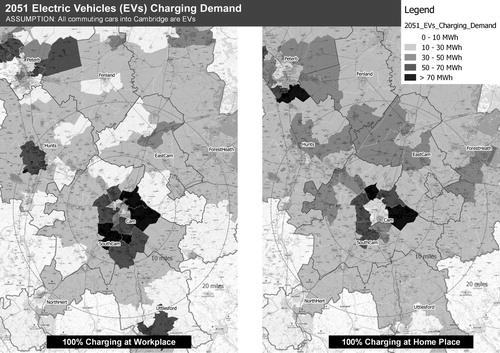
The results point out that further concentration of employment in Cambridge () would result in soaring charging demand within the city limits if all commuting EVs would charge at the workplace. This is likely to pose considerable problems because upgrading the energy infrastructure in the dense center of the city will require a comparatively high investment, accompanied with severe disruption to local businesses and communities. However, the comparison between all EVs charging at the workplace versus home indicates that part of the demand increase may be shifted away from the center to locations where there is less demand (especially in the short term) through, for example, offering incentives for charging at home and/or disincentives for charging and/or parking at workplace. shows that, in the Fringe Growth case, the potential of such a load-shifting policy would be less effective due to the close proximity of home and work locations. However, the different scenarios illustrate the potential use of the CDT prototype to address interdependence across the policy domains of land-use planning, transport, energy, and air quality.
Conclusions: A Socio-Technical Perspective on Smart City Technologies
The research question that this study aimed to address was: How does a shift in focus from a purely technical towards a socio-technical perspective influence the design and implementation of smart city technologies? To answer this question we used the case of the digital twin concept as applied to the urban scale (City-Scale Digital Twin), the development of which has so far mainly been driven by the supply-side with a focus on technical functionality. While the recommendations listed below are derived from the CDT case, they also highlight important considerations for various ongoing digitalization processes in the urban built environment as part of the smart city agenda.
The interdisciplinary approach, informed by a socio-technical perspective, highlights the need for a more nuanced conceptualization, design, and implementation of digital twins (including CDTs) based on the purpose they aim to serve and the context in which they need to operate. In terms of purpose, there is a need to bring together traditional urban modeling and the new opportunities that the digital twin idea offers through a challenge-led agenda. In terms of context, characteristics of urban governance, including the use of model outputs as evidence in policy decision-making must be considered.
The development of the Cambridge CDT prototype through a participatory process highlights a number of issues which future research on digital twins needs to address. First, developing CDTs requires collating data from both conventional (e.g., census, structured surveys) and emerging (e.g., sensory technology) sources. Working with prospective users, however, made it explicit that collecting and linking data from different sources must be driven by specific policy and practical questions. There is urgent need for a shift towards a challenge-led approach for collecting data from, and sharing data with, specific societal actors, due to the resources (financial and human) required and the risks involved (e.g., changing power dynamics, privacy, and security issues).
However, adopting a challenge-led approach and identifying the purpose of CDTs is not straightforward. The participatory process called attention to the difficulties involved in reframing broad policy goals into targets which CDTs can address, and in translating model outputs into relatable and actionable narratives. A need has, therefore, been identified for prospective users to better understand the functioning and the boundaries of data-driven decision-making support tools (including CDTs) in terms of opportunities, limitations, risks, and uncertainties. Moreover, modelers (and the supply side more generally) must engage with a diverse set of societal actors, as well as a wider spectrum of policy alternatives and modeling approaches, in order to be able to provide contextually relevant and appropriate insights and recommendations.
In conclusion, the socio-technical perspective adopted in this study points to the potential and benefits of conceptualizing, designing, and implementing CDT systems (involving the digital tools as well as their governance) organically as assemblages reflecting local contextual opportunities and constraints, by utilizing and gradually updating and expanding existing tools, processes, and expertise. From a technical perspective, loosely coupling specialist models representing different infrastructure systems through small “boundary” modules developed to address pressing local challenges allows for phased development and continuous evolution of CDTs. In turn, this process represents an opportunity for continued demonstration of value of this type of evidence in planning policy-making and implementation—which is essential to justify the costs involved and ensure the delivery of the promised benefits.
Despite the encouraging results, this pilot study has a number of limitations. First, the study was conducted over a relatively short time period (nine months) with modest resources. As such, issues of long-term continuity and function expansion remain uncertain. Opportunities for post-implementation feedback collection and evaluation were also limited in this pilot phase. Second, it focused on a specific problem with a limited scope covering only policy domains of land-use, transport, energy, and air quality. Third, the CDT prototype in its current stage of development is largely based on open-source and static data sets. Understanding the implications involved in linking dynamic data streams to the analytical model is yet to be explored.
Batty (Citation2019) uses the analogy “a map is not the territory (or is it)” to describe the intertwined relationship between the digital twin and the physical system it aims to represent. Inevitably, any CDT will always remain an incomplete map of the physical city. This inevitability lies not only in that creating digital twins, as a scientific enquiry, always involves certain abstractions, but also in the changes in our ability and motivation to create representations of cities at any given point in time. Nevertheless, digital representations are (or can become) integral parts of the city as efforts made at evolving them may well contribute to improving the social systems making those efforts.
Acknowledgments
The authors are grateful for the support of local authority partners in Cambridge, in particular Daniel Clarke and Gemma Schroeder from the Smart Cambridge team. The authors would like to acknowledge Noura Wahby, Nicole E. Badstuber, and Tianren Yang for their assistance on data collection and analysis.
Disclosure Statement
No potential conflict of interest was reported by the authors.
Additional information
Funding
Notes on contributors
T. Nochta
T. Nochta is a research associate in urban systems in the Department of Engineering, University of Cambridge, Cambridge, United Kingdom
L. Wan
L. Wan is a university lecturer in the Department of Land Economy, University of Cambridge, Cambridge, United Kingdom
J. M. Schooling
J. M. Schooling is the director of the Centre for Smart Infrastructure and Construction in the Department of Engineering, University of Cambridge, Cambridge, United Kingdom
A. K. Parlikad
A. K. Parlikad is a reader in the Department of Engineering, University of Cambridge, Cambridge, United Kingdom
Notes
1 Formulation of the respective model for place of work and method of travel can be found in the Supplemental material.
2 The LUISA model is a land-use and transport interaction model developed for the Cambridgeshire and Peterborough Independent Economic Review (CPIER, Citation2018).
3 The multi-scale simulation is achieved through coupling the CDT prototype with the Quant model developed at the Centre for Advanced Spatial Analysis, UCL (http://quant.casa.ucl.ac.uk)
References
- A. Anas and Y. Liu, “A Regional Economy, Land Use, and Transportation Model (RELU-TRAN©): Formulation, Algorithm Design, and Testing,” Journal of Regional Science 47: 3 (2007) 415–455. doi: 10.1111/j.1467-9787.2007.00515.x
- M. Batty, The New Science of Cities (Cambridge: MIT Press, 2013).
- M. Batty, “Models Again: Their Role in Planning and Prediction,” Environment and Planning B: Planning and Design 42: 1 (2015) 191–194. doi: 10.1068/b4202ed
- M. Batty, “Digital Twins,” Environment and Planning B: Urban Analytics and City Science 45: 5 (2018) 817–820.
- M. Batty, “A Map Is Not the Territory, or Is It?” Environment and Planning B: Urban Analytics and City Science 46: 4 (2019) 599–602
- A. Bolton, L. Butler, I. Dabson, M. Enzer, M. Evans, T. Fenemore, F. Harradence, et al., The Gemini Principles. Report of Cambridge: Centre for Digital Built Britain, 2018. <www.cdbb.cam.ac.uk/DFTG/GeminiPrinciples> Accessed March 26, 2020.
- A. Bryman, Social Research Methods (Oxford: Oxford University Press, 2016).
- Cambridge City Council, Cambridge Local Plan (2018–2031) (Cambridge: Cambridge City Council, 2018) <www.cambridge.gov.uk/sites/default/files/docs/Local Plan 2006.pdf> Accessed March 26, 2020.
- Cambridgeshire and Peterborough Combined Authority, Cambridgeshire and Peterborough Interim Local Transport Plan (Cambridge: CPCA, 2017) <https://cambridgeshirepeterborough-ca.gov.uk/assets/Transport/Interim-Transport-Plan-170628.pdf> Accessed March 26, 2020.
- Cambridgeshire County Council, Cambridgeshire Local Transport Plan (2011–2031): Long Term Transport Strategy (Cambridge: Cambridgeshire County Council, 2015) <https://www.cambridgeshire.gov.uk/residents/travel-roads-and-parking/transport-plans-and-policies/local-transport-plan> Accessed March 26, 2020.
- Cambridgeshire Insight, Cambridgeshire: 2015-Based Population Forecasts by District and Ward (Cambridge: Cambridgeshire Insight, 2015) <https://cambridgeshireinsight.org.uk/population-estimates-old/> Accessed March 26, 2020.
- Cambridgeshire Insight, Population – Population Reports (Cambridge: Cambridgeshire Insight, 2018) <https://cambridgeshireinsight.org.uk/population/report/view/f7de925f5608420c825c4c0691de5af2/E07000008/> Accessed March 26, 2020.
- L. K. Campbell, E. S. Svendsen, and L. A. Roman, “Knowledge Co-Production at the Research–Practice Interface: Embedded Case Studies from Urban Forestry,” Environmental Management 57:6 (2016) 1262–1280. doi: 10.1007/s00267-016-0680-8
- L. Carvalho, “Smart Cities from Scratch? A Socio-Technical Perspective,” Cambridge Journal of Regions, Economy and Society 8: 1 (2015) 43–60. doi: 10.1093/cjres/rsu010
- CPIER, The Cambridgeshire and Peterborough Independent Economic Review: Final Report (Cambridge: CPIEC, 2018) <https://www.cpier.org.uk/final-report/> Accessed March 26, 2020.
- S. Darby, “Making Space for Co-Produced Research ‘Impact’: Learning from a Participatory Action Research Case Study,” Area 49: 2 (2017) 230–237. doi: 10.1111/area.12321
- Dassault Systèmes, Meet Virtual Singapore, the City’s 3D Digital Twin (2018) <https://govinsider.asia/digital-gov/meet-virtual-singapore-citys-3d-digital-twin/> Accessed March 26, 2020.
- S. Davoudi, “Evidence-Based Planning,” DisP: The Planning Review 42: 165 (2006) 14–24.
- O. Dawkins, A. Dennett, and A. Hudson-Smith, “Living with a Digital Twin: Operational Management and Engagement Using IoT and Mixed Realities at UCL’s Here East Campus on the Queen Elizabeth Olympic Park,” in Proceedings of the 26th Annual GIScience Research UK Conference: GISRUK 2018. (Leicester, 2018) <https://discovery.ucl.ac.uk/id/eprint/10056521/> Accessed March 26, 2020.
- DfT. 2018. Transport Analysis Guidance (UK: Department for Transport, 2018) <www.gov.uk/guidance/transport-analysis-guidance-webtag> Accessed March 26, 2020.
- M. Flinders, M. Wood, and M. Cunningham, “The Politics of Co-Production: Risks, Limits and Pollution,” Evidence and Policy: A Journal of Research, Debate and Practice. 12: 2 (2016) 261–279. doi: 10.1332/174426415X14412037949967
- Greater Cambridge Partnership, City Access and Bus Service Improvements Update (Cambridge: GCP, 2018) <https://scambs.moderngov.co.uk/documents/s108578/7-City Access.pdf> Accessed March 26, 2020.
- M. Grieves and J. Vickers, “Digital Twin: Mitigating Unpredictable, Undesirable Emergent Behavior in Complex Systems,” in Transdisciplinary Perspectives on Complex Systems: New Findings and Approaches (Cham: Springer International, 2017), 85–113.
- L. Hooghe and G. Marks, “Types of Multi-Level Governance,” European Integration Online Papers (EIoP) 5: 11 (2001) <https://papers.ssrn.com/sol3/papers.cfm?abstract_id=302786> Accessed March 26, 2020.
- Y. Jin, M. Echenique, and A. Hargreaves, “A Recursive Spatial Equilibrium Model for Planning Large-Scale Urban Change,” Environment and Planning B: Planning and Design 40: 6 (2013) 1027–1050. doi: 10.1068/b39134
- R. Kitchin, “Making Sense of Smart Cities: Addressing Present Shortcomings,” Cambridge Journal of Regions, Economy and Society 8: 1 (2015) 131–136. doi: 10.1093/cjres/rsu027
- H. B. Ku and J. Y. C. Kwok, “The Action Research Practice of Urban Planning: An Example from Hong Kong,” in The SAGE Handbook of Action Research, edited by Hilary Bradbury (London: Sage, 2015) 118–130.
- I. S. Lowry, A Model of Metropolis, Report (Rand Corporation, Santa Monica, CA, USA, 1964)
- A. Maiello, C. V. Viegas, M. Frey, and J. D. Ribeiro, “Public Managers as Catalysts of Knowledge Co-Production? Investigating Knowledge Dynamics in Local Environmental Policy,” Environmental Science and Policy 27 (2013) 141–150. doi: 10.1016/j.envsci.2012.12.007
- L. Meuleman, Public Management and the Metagovernance of Hierarchies, Networks and Markets (Heidelberg: Physica-Verlag, 2008).
- L. Mora and M. Deakin, Untangling Smart Cities: From Utopian Dreams to Innovation Systems for a Technology-Enabled Urban Sustainability (Amsterdam: Elsevier, 2019).
- NIC, Data for the Public Good (London: National Infrastructure Commission, 2017) <https://www.nic.org.uk/publications/data-public-good/> Accessed March 26, 2020.
- T. Nochta, L. Wan, J. M. Schooling, L. Lemanski, A. K. Parlikad, and Y. Jin, “Digitalisation for Smarter Cities: Moving from a Static to a Dynamic View,” Proceedings of the Institution of Civil Engineers - Smart Infrastructure and Construction 171:4 (2018) 117–130. doi: 10.1680/jsmic.19.00001
- T. Nochta, N. E. Badstuber, and L. Wan, “Evidence-Informed Decisionmaking in Multi-Stakeholder Settings: The Case of City Digital Twins for Planning and Management,” paper presented at Data for Policy 2019 (London, 11–12 June, 2019a)
- T. Nochta, N. E. Badstuber, and N. Wahby, “On the Governance of City Digital Twins: Insights from the Cambridge Case Study,” CDBB Working Papers 12 (Cambridge: Centre for Digital Built Britain, 2019b) <www.repository.cam.ac.uk/handle/1810/293984> Accessed March 26, 2020.
- T. Nochta, A. Parlikad, J. M. Schooling, N. E. Badstuber, and N. Wahby, “The Local Governance of Digital Technology: Implications for the City-Scale Digital Twin,” Report (Cambridge: Centre for Digital Built Britain, 2019c) <www.repository.cam.ac.uk/handle/1810/296276> Accessed March 26, 2020.
- NRF, Virtual Singapore (Singapore: National Research Foundation, November 7, 2018 ) <https://www.nrf.gov.sg/programmes/virtual-singapore> Accessed March 26, 2020.
- J. Pierre, “Comparative Urban Governance: Uncovering Complex Causalities,” Urban Affairs Review 40: 4 (2005) 446–462. doi: 10.1177/1078087404273442
- M. Polk, “Transdisciplinary Co-Production: Designing and Testing a Transdisciplinary Research Framework for Societal Problem Solving,” Futures 65 (January 2015) 110–122. doi: 10.1016/j.futures.2014.11.001
- C. Pollitt and G. Bouckaert, Public Management Reform: A Comparative Analysis: New Public Management, Governance, and the Neo-Weberian State (Oxford: Oxford University Press, 2011).
- C. D. F. Rogers, “Engineering Future Liveable, Resilient, Sustainable Cities Using Foresight,” Proceedings of the Institution of Civil Engineers: Civil Engineering 171: 6 (2018) 3–9.
- C. Skelcher, “Changing Images of the State: Overloaded, Hollowed-out, Congested,” Public Policy and Administration 15: 3 (2000) 3–19. doi: 10.1177/095207670001500302
- F. Tao and Q. Qi., “Make More Digital Twins,” Nature 573: 7775 (2019) 490–491. doi: 10.1038/d41586-019-02849-1
- M. Tomko and S. Winter, “Beyond Digital Twins: A Commentary,” Environment and Planning B: Urban Analytics and City Science 46: 2 (2019) 395–399.
- G. Verbong, F. W. Geels, and R. Raven, “Multi-Niche Analysis of Dynamics and Policies in Dutch Renewable Energy Innovation Journeys (1970–2006): Hype-Cycles, Closed Networks and Technology-Focused Learning,” Technology Analysis & Strategic Management 20: 5 (2008): 555–573. doi: 10.1080/09537320802292719
- P. Waddell, “Integrated Land Use and Transportation Planning and Modelling: Addressing Challenges in Research and Practice,” Transport Reviews 31: 2 (2011) 209–229. doi: 10.1080/01441647.2010.525671
- L. Wan and Y. Jin, “Assessment of Model Validation Outcomes of a New Recursive Spatial Equilibrium Model for the Greater Beijing,” Environment and Planning B: Urban Analytics and City Science 46: 5 (2017) 805–825.
- L. Wan, S. Gao, C. Wu, Y. Jin, M. Mao, and L. Yang, “Big Data and Urban System Model: Substitutes or Complements? A Case Study of Modelling Commuting Patterns in Beijing,” Computers, Environment and Urban Systems 68 (2018) 64–77. doi: 10.1016/j.compenvurbsys.2017.10.004
- L. Wan, T. Nochta, and J. M. Schooling, “ Developing a City-Level Digital Twin: Propositions and a Case Study,” in International Conference on Smart Infrastructure and Construction 2019 (ICSIC) (London: ICE, 2019) 187–194.
- M. Wegener, “Operational Urban Models State of the Art,” Journal of the American Planning Association 60: 1 (1994) 17–29. doi: 10.1080/01944369408975547
- M. Wegener, “Overview of Land-Use Transport Models,” Handbook of Transport Geography and Spatial Systems 5 (2004) 127–146. doi: 10.1108/9781615832538-009
- A. Wiig, “The Empty Rhetoric of the Smart City: From Digital Inclusion to Economic Promotion in Philadelphia,” Urban Geography 37: 4 (2016) 535–553. doi: 10.1080/02723638.2015.1065686