
Using the United States border with Mexico, the Spanish barrier around Melilla in Morocco, and Israel’s walls in Palestine, Up Against the Wall is a visual exploration of nation-state imposed borders as they become physical and evolve.
The project first took root in 2002 as I stood alongside Palestinian farmers who were losing their land as Israel began construction on what is now a nearly 500-mile long, largely 25-foot high concrete wall inside the West Bank of occupied Palestine. I watched from the first groundbreaking as this structure—called a security barrier by some, the apartheid wall by others—cut its way through the orchards and groves, through the villages and through the hearts of the people who lived here.
Initially, I was astounded by such a political maneuver, but soon came to realize that the idea of building a structure to keep the “Other” out or lock “Them” in was not so unusual a reality, and that in many cases, people by the scores were willing to risk imprisonment or death in attempt to cross.
I found a great deal of documentation focused on the people impacted by such policy but a lack of focus on the structures themselves—and even less on the juxtaposition of multiple structures in different regions. Comparing these structures gives us space to visually comprehend global relationships of power. Considering these structures allows us to ask why these structures exist, who builds them, what ends they serve, and whom they impact. Visualizing these structures offer those of us who are not forced up against walls in this world a glimpse of the reality we are building.
Up Against the Wall allows us to also investigate the role of Israel in the development of the southern U.S. border. Since at least 2004, contracts for several U.S.-Mexico border security developments have gone to Israeli security entities, such as Elbit Systems, who boast that their technology is superior because they are able to test and develop it in real time on a live Palestinian population. An Israeli Defense Forces soldier has even been quoted referring to Gaza as a “great laboratory.”
These developments involve more than simply building up the actual structured border itself, but the construction of a virtual border miles from the border itself, incorporating drones, cameras, and radar and motion sensors connected to control rooms hundreds of miles away. Israeli security companies, with former IDF officers in leadership positions, also train U.S. Department of Homeland Security immigration agents, expanding their partnerships beyond technology and funding to include hand-to-hand combat training. In this way, the testing grounds initiated in Gaza and the West Bank expand to the southern United States border region in an ever-increasing global project of militarization and policing the “Other.”
The border at Melilla, a Spanish enclave on the northern coast of Morocco, meanwhile, gives us the opportunity to scrutinize the outsourcing of border policing. As one of the only European Union land borders on the African continent, migrants who succeed to set foot in this enclave are, at least in theory, able to apply for asylum. In reality, migrants are physically and violently deterred from doing so. In 2005, at least six migrants were shot dead trying to cross. In response, to avoid human rights scrutiny, the European Commission has allocated over 40 million euros a year for Morocco to secure the border.
Up Against the Wall is also about making community connections, and creating a canvas for collaboration across social movements, and a space where grassroots organizations, communities, and activists can highlight and build from our intersections. In this way, that which divides us is subverted, turning walls into bridges that connect. Through these collaborations, we seek a different kind of solution.
Figure 1: Playas de Tijuana, Mexico, 2014 The southern United States border runs approximately 1,960 miles. Roughly 700 miles of it contains physical structures.
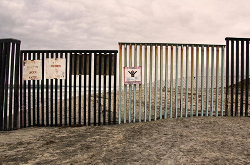
Figure 2: Jerusalem, 2008 Israel’s wall in the West Bank was first constructed in 1992 during the Oslo Accords. That series of small concrete slabs expanded starting in 2002 when Israel first broke ground for what is now a near-continuous barrier close to 500 miles long.
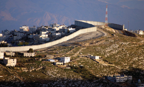
Figure 3: Melilla, 2007 Melilla is a Spanish enclave on the northern coast of Morocco. As one of the only European Union land borders on the African continent, migrants who succeed to set foot in this enclave are, according to international law, able to apply for asylum. In reality, Moroccan soldiers physically and violently deter migrants from reaching the border at all.
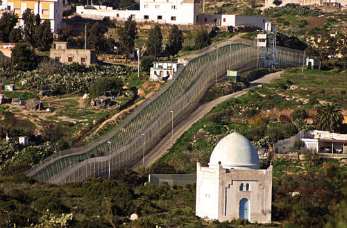
Figure 4: Erez Crossing, Gaza, 2008 The structure built around Gaza broke ground in 1994 and was completed in 2005 with a final section on the Gaza/ Egyptian border. This barrier, alongside a strip of sea also controlled by Israel, leaves Gaza completely surrounded.
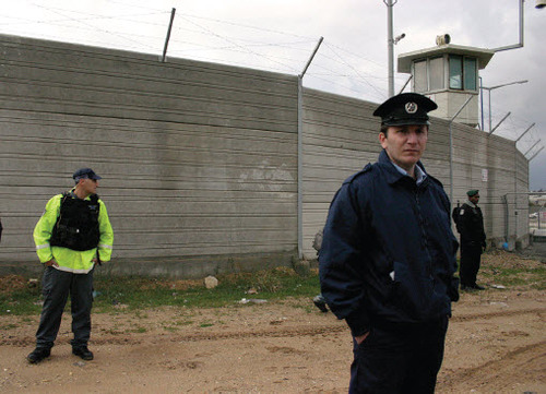
Figure 5: Tijuana, Mexico, 2014 One section of the wall between Tijuana, Mexico and the United States is currently a double-layer structure—the first section of the barrier was built in the mid-1990s and consists of 14 miles of welded steel. In the early 2000s, a secondary, 14 to 18-foot high structure was added 130 feet north of the first.
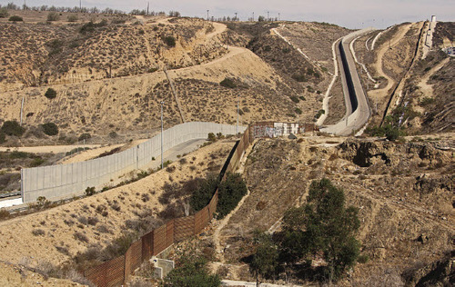
Figure 6: West Bank, Palestine, 2005 Israel’s wall in Palestinian agricultural areas is made up of a triple-layer fence, with barbed wire along the top and sides, patrol roads on both sides, and a series of gates. Palestinians with agricultural land on the other side of the wall are required to apply for permits in order to cross.
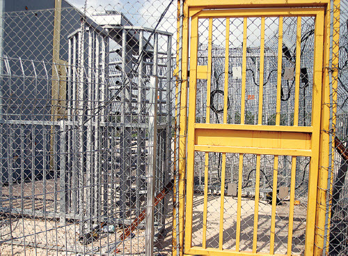
Figure 7: Melilla, 2007 Migrants sometimes travel for four to six years to reach the Spanish side of the border. Some attempt to cross via the sea, swimming for hours to avoid detection, some attempt to smuggle themselves in the engine compartments of trucks, and some simply try to climb over the barrier. Others still succeed in crossing only to be held in Spanish-government-run temporary migrant holding centers, some for years, awaiting the legal system to either award them papers or deport them.
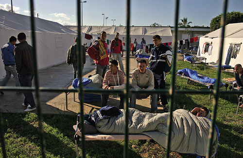
Figure 8: West Bank, Palestine, 2005 The majority of this wall is built deep within the West Bank, effectively annexing an additional 12% of Palestinian West Bank land not previously held by Israel.
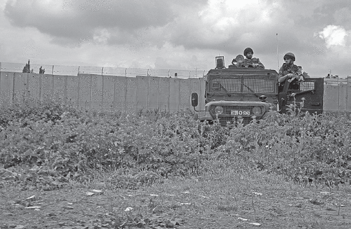
Figure 9: Nogales, Sonora, Mexico, 2006 Several hundred migrants a year die due to exposure attempting to cross the southern U.S. border—and these are only the reported deaths, leaving an untold number of abandoned bodies unknown.
Figure 10: Melilla, 2007 Until 1999, the border separating Melilla, Spain from Morocco was not much more than a roll of barbed wire. Today this border consists of seven miles of three 20-foot high fences running parallel to each other topped with barbed wire, regular watch posts, and a patrol road running in between. Underground cables connect spotlights, noise and movement sensors, and video cameras to a central control booth. If a migrant or asylum-seeker succeeds in scaling the first section of the Spanish border fence, they land in a mess of razor-wire rods designed to inflict grave damage.
Figure 11: Nogales, Arizona, U.S., 2006 As with most structures built for similar purposes, the southern United States border does not deter migrants from attempting to cross, but instead only pushes them to take riskier and more deadly routes.
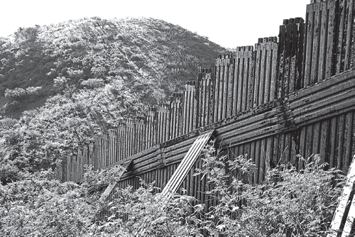
Figure 12: Looking into Bethlehem, Palestine, 2005 The International Court of Justice has found this structure to be illegal based on the Fourth Geneva Convention, a treaty on the treatment of civilians living in war zones.
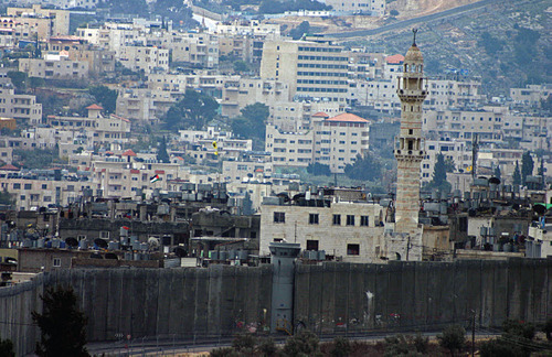
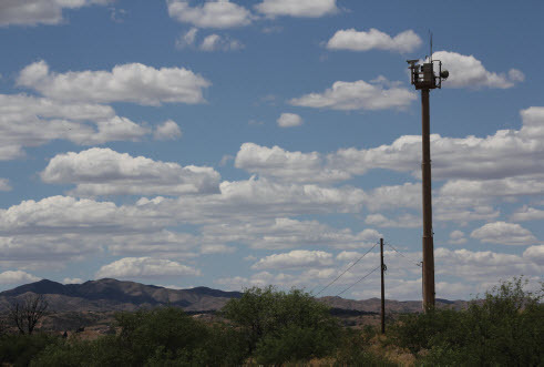
Figure 13: Nogales, Arizona, U.S., 2014 Concretely highlighting the global connections of power and control, Israeli security firms who develop their technology on the occupied Palestinian population have tested out technologies that they later employ through lucrative contracts on the southern U.S. border.
Additional information
Notes on contributors
K. Flo Razowsky
K. Flo Razowsky, currently located in Los Angeles, is a photographer who has supported liberation movements and photographed in Palestine, Bahrain, Serbia, Ukraine, Berlin, the United States and Mexico, and many of the borderlands in between. Razowsky works to combine art with activism, which they believe can move people to act. See K.’s work at http://www.flowalksfree.com/.