
ABSTRACT
When responding to an incident, Norwegian rescue services in the Arctic have to consider weather conditions, surface features, infrastructure scarcity, and technological availability. To some extent, safe navigation is based on the use of digital maps. In this article, I analyze how maps are assembled for their role as navigation tools and how this interlinks with the capacity for timely incident response in the Arctic context. My study is based on new materialism, which pays attention to interactions. I investigate maps as processes, focusing on how they are constituted through practices. Therefore, I follow heterogeneous entanglements of more-than-human actors. In this article, I focus on localities related to the Svalbard archipelago, including incident response on land, the Joint Rescue Coordination Centre, and information support services. I explore the assemblages of maps through three aspects: institutional mapping of Svalbard, avalanche observations around Longyearbyen, and mapping practices of the local rescue services on land. I argue that safe navigation, and consequently a timely incident response, is embedded in more-than-human networks and depends on their flexibility and durability. Divergence of mapping practices between those in Svalbard and on the mainland further highlights the need for an analysis of socio-technological entanglements in the Arctic.
Introduction
But if you’re getting into bad weather, and visibility is low, you have to use the tracks. […] Because in bad weather you can’t see, so you have to have maps then. And a GPS’. (Participant 1 from Field Operations, 2021)
Coupled with the quote from a rescue responder, this rescue story from Svalbard reveals the complexity of search-and-rescue (SAR) operations in Arctic settings. Weather and terrain conditions have to be considered by responders, as they can significantly hinder the efforts of rescuers, limiting movement and navigation. Furthermore, low visibility can require rescuers to rely on their maps as the only means of navigation. Thus, emphasizing the importance of the availability of updated maps and knowledge regarding the area’s terrain and its changes. I center this article around mapping practices in Svalbard to better understand the interplay between these more-than-human interactions and response capacity in the Arctic. I argue that analyzing maps as processes allows to notice wider networks of heterogeneous actors interlinked with a safe and timely response.
More-than-human interactions are underexplored in both, the SAR operational and the Arctic regional contexts. Studies regarding SAR to date mostly relate to emergency preparedness, risk mitigation, or disaster management. They analyze experiences of Norwegian–Russian cooperation through political and operational dimensions (Sydnes et al., Citation2017); disaster diplomacy between Norway and Russia (Duda et al., Citation2022; Kelman et al., Citation2020); safety management in relation to shipping in the Arctic (Mileski et al., Citation2018); SAR operational management (Andreassen et al., Citation2020; Andreassen & Borch, Citation2020); risk assessments on increasing traffic (Marchenko et al., Citation2018); and existing SAR response capacity and infrastructure (Christodoulou et al., Citation2022; Dalaklis & Drewniak, Citation2020; Kruke & Auestad, Citation2021). SAR response on land in the Norwegian High North has been analyzed based on the unprecedented avalanches in Longyearbyen in 2015 and 2017, with attention to the role of unorganized volunteers (Tengesdal & Kruke, Citation2018) and organizational learning processes as a part of crisis management triggered by these incidents (Sydnes et al., Citation2021). Studies repeatedly note the challenges posed by the Arctic environment (harsh climate, long distances, and scarce infrastructure) and emphasize the need for integrating and exchanging more high-quality maritime data for maritime rescue efficiency (e.g. Kvamstad et al., Citation2009). While analyses regarding SAR efforts are mostly focused on the availability of the infrastructure, inter-organizational cooperation, and management roles, more-than-human interactions are underexplored.
From the regional aspect, heterogeneous interactions in the Arctic are analyzed in relation to use or placement of technologies and knowledge production. For example, attention is given to how technological infrastructure, such as data centers, is entangled with the surroundings and communities in Iceland (Johnson, Citation2019) and northern Sweden (Vonderau, Citation2019). From the perspective of avalanche risk assessment, Solli and Ryghaug (Citation2014) analyzed how local practices of knowing interlink with the landscape in northern Norway. A study about the testing of driverless vehicles in Arctic Norway (Ryghaug et al., Citation2022) has shown the importance of testing technology in different environments. Authors note that the use of Global Positioning System (GPS) in the Arctic can be challenged by specific elements, such as the Northern Lights. These studies emphasize the messy entanglements of social and technological – socio-technological – practices and the unexpected ways they can turn out, thereby highlighting the need for such critical inquiry. Outside of the Arctic region, analyzing socio-technological entanglements allows to better understand hybrid structures and their failure in light of compound disasters (Fortun et al., Citation2017). Furthermore, this mode of inquiry can show how the crisis management is practiced daily in the control rooms, connecting more-than-humans through various spatialities (November & Créton-Cazanave, Citation2016).
With this article, I explore more-than-human networks interlinked with the movement of Norwegian rescue services on land in Svalbard. In particular, I pay attention to the use of digital maps and how they are assembled for a specific role as a navigational aid. As shown, previous inquiries into SAR or socio-technological entanglements do not cover this particular area of interest. With technological advancement, digital maps play a more active role in decision making, information communication, and shared situational awareness. Norwegian rescue services are based on collaboration between public, private, and volunteer sectors (Justis- og beredskapsdepartementet, Citation2018). Therefore, maps have the potential to significantly enhance a collaborative rescue action. However, even with growing attention towards the operational environment of SAR efforts in the Arctic, more-than-human networks are underexplored, leaving such tools as maps in the margins. When analyzing the use of maps in Svalbard, I noticed that they are mostly used as navigational aid for land operations, making them indispensable in tight situations. However, study participants emphasized that the available maps do not include all the necessary information for safe navigation. Therefore, certain practices involving more-than-human networks are in place to collect the missing data. The availability of these practices underlines the necessity of inquiring into the socio-technological entanglements that enable maps to be used as a navigation tool.
In this paper, I present information about Norwegian rescue services in the Svalbard archipelago. I discuss my theoretical framework, methods, and data. While focusing on land SAR efforts, I follow one of the roles assumed by maps when employed by rescue services, that of a navigation tool, and how they are assembled. I do so by analyzing three aspects of mapping: land mapping, avalanche mapping, and local practices of mapping. I finish with a concluding discussion about how maps interlink with the SAR response capacity. I argue that following the processual aspect of maps – how they are assembled for a particular function – allows for the noticing of heterogeneous actors interlinking with rescuers’ capacity for a timely response.
Rescue services in svalbard
The Svalbard archipelago, part of the Kingdom of Norway, is situated in the High North, where the climate can be challenging. With an average annual temperature of −4°C in the town of Longyearbyen, the region challenges the performance of responders, as cold can affect both humans and equipment (Albrechtsen & Indreiten, Citation2021). Furthermore, climate change on Svalbard is experienced through changing weather patterns, such as extreme precipitation events (Müller et al., Citation2022). This is added to other climatic conditions, which have a significant impact on safe navigation: atmospheric icing, rapid weather change, lack of daylight, or excessive daylight (Albrechtsen & Indreiten, Citation2021).
Navigation in the archipelago is complicated by other factors. First, the high latitude of the region affects navigation and communication systems (Kruke & Auestad, Citation2021). Second, the scarcity of infrastructure adds to the reduced availability of navigational aids or seamarks (Kruke & Auestad, Citation2021). This is further emphasized by the long distances between the settlements with no connecting roads (Duda et al., Citation2022). Third, with the archipelago spreading over 61,022 square kilometers (Kruke & Auestad, Citation2021), and with only a handful of settlements, the rescue response capacity is stretched. The largest town and administrative center is Longyearbyen, which is also experiencing growing tourism traffic (Hovelsrud et al., Citation2021). Other settlements include Barentsburg and Pyramiden, Hornsund, and Ny-Ålesund (Statistics Norway, Citation2023). In addition to difficult navigation, the increasing presence of tourists and other visitors in the Svalbard archipelago adds to the pressure for rescue services. Thus, SAR responders have to consider large distances, the limited capacity of the rescue services, and communication and navigation challenged by the scarcity of infrastructure and the complexity of the terrain.
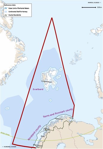
Norwegian rescue services are responsible for a large area of the Arctic region. In 2011, the Arctic Council signed the Agreement on Cooperation on Aeronautical and Maritime Search and Rescue in the Arctic. The Agreement is intended to ‘strengthen aeronautical and maritime search and rescue cooperation and coordination in the Arctic' (Arctic Council, Citation2011, Article 2). It promotes cooperation and SAR preparedness and delineates search-and-rescue regions for each party. Accordingly, Norway is committed to oversee an area from the North Pole to 66°33′44″N, the current Arctic Circle (Arctic Council, Citation2011, Annex 1). The responsibility for overall coordination of SAR operations in this region falls under the command of the Joint Rescue Coordination Centre in northern Norway (henceforth JRCC), situated in Bodø. Its areal responsibility is marked by the crimson border in . The JRCC closely communicates with local authorities in Svalbard (the police at the office of the Governor of Svalbard) and coordinates actions with other governmental institutions which are able to assist in a SAR effort in the North (Ministry of Justice and Public Security, Citation2016).
Figure 1. Area of responsibility assumed by the JRCC in Northern Norway. Adapted from Barentswatch (Citationn.d.) and Hovedredningssentralen (Citationn.d.).
The Governor of Svalbard in Longyearbyen is tasked with coordinating SAR efforts regionally and with maintaining the capability of the services to respond (Kruke & Auestad, Citation2021). To fulfill the latter, the Governor’s office owns a service vessel, Polarsyssel; has an agreement with a private company, Lufttransport AS, to hire two helicopters if a situation occurs; and, along with the JRCC, is in close communication with the NCA and the NCG (Ministry of Justice and Public Security, Citation2016). The Coast Guard, however, is more focused on fishing vessels and can be far away from a ship in distress (Kruke & Auestad, Citation2021). In addition to these resources, there is a voluntary rescue service provided by the Red Cross Auxiliary Corps (Ministry of Justice and Public Security, Citation2016).
SAR incidents around Svalbard happen on land, at sea, and in the air, in varying proximity to settlements. These can include immobilized ships (Andreassen et al., Citation2020); crashed aircraft (Duda et al., Citation2022); or any outdoor activity, such as skiing or snowmobiling (Kelman et al., Citation2020). In the summer, most incidents can be resolved with helicopter service, while in the winter, weather conditions can make this difficult (Participant 2 from Field Operations, 2021). With this article, I focus on land operations. I investigate mapping practices by responders on land and by related information support services. The analysis includes how the land maps are modelled, how the police and volunteers practice the maps, and what additional sources of information ensure safe navigation.
Theoretical framing
The theoretical framework of this study is inspired by the vibrant field of new materialism, and more precisely, by actor-network theory (ANT). This approach focuses on interactions between heterogeneous actors as their constitutive force (Mol, Citation2010). ANT calls for a thorough examination of interactions – actor-networks – to understand a phenomenon (Latour, Citation1996). While actors can be anything and anyone involved in interactions, ANT does not assume symmetry over human and nonhuman actors (Latour, Citation2005). Instead, ANT calls for going beyond dialectics, such as social and natural, or intentional and causal, and paying attention to how the actors are associated (Latour, Citation2005). Contrary to its name, ANT is not a theory, at least, not in a classical sense; it does not provide explanations, it is concerned about tracing effects rather than causes, and it is open to surprises (Mol, Citation2010). It is a framework that spurs thinking about ‘matter in relation’, rather than ‘matter itself’, where matter always acts in concert and should be investigated as such (Abrahamsson et al., Citation2015). Exploring an entity in its relationality opens up to its multiplicity – various constellations of interactions (Pyyhtinen, Citation2016) – allowing the researcher to spot differences in the assemblages. This angle applies to various material-semiotic networks, for example tracing the process of providing food supplements (Abrahamsson et al., Citation2015), or inquiring about a failure of the stock market (Pyyhtinen, Citation2016). It allows the noticing of the interplay between discourses and matter without presupposing the superiority of one over the other.
Applying ANT to my study means maps are perceived as processes – as assemblages – of heterogeneous actors, acting and being enacted through actor-networks. While paper maps are not yet obsolete, they are not preferred by responders as the primary source of information; therefore, I focus on the use of digital maps. I investigate how maps assemble, reassemble, or disassemble when they are employed by Norwegian rescue services. Assemblage here notifies an unfixed ‘process of bundling' (Law, Citation2004, p. 42), leading to the stabilization of networks, their durability, and their fluidity (Müller & Schurr, Citation2016). This means I focus on the situational use of maps and what comes into play when maps act the way they do – whether they are interlinked with organizational practices, regulations, funding, infrastructure availability, or landscape features. I see this approach fitting, because digital maps assume different roles during SAR operations, influencing decision making processes, information communication and situational awareness. Focusing on one feature (such as representation) would be reductive regarding maps. They are an intrinsic part of a SAR effort, connecting localities from modelling to employment sites. Following maps as processes entails looking into heterogeneous assemblages, stretching beyond the human–computer interface. Therefore, they cannot be analyzed independently of the socio-material interactions where they are practiced.
Attention to how maps are practiced is aligned with critical cartography, which in recent decades has experienced a critical shift from maps as representations towards discussions about power and knowledge (Del Casino & Hanna, Citation2005), and to a post-representational turn (Rossetto, Citation2019), moving away from analyzing maps as being determined to represent or perform. Instead, maps are enacted, and therefore, they assume roles through material-semiotic practices where they are in constant becoming as ‘mappings' (Kitchin & Dodge, Citation2007, p. 335), with unpredictable ways of employment (Perkins, Citation2008). However, while paying attention to mapping practices – how maps are practiced – a division is maintained between inquiries about producing maps and employing them (e.g. Cosgrove, Citation2008; Dodge et al., Citation2009). Here, I focus on both of these aspects without making a clear distinction. Following maps as processes and inquiring about the production of maps and their employment by rescue services allows me to notice how these practices interlink.
More-than-human interactions are the constitutive entanglements in the process of mapping. In this article, I use the term ‘more-than-human' to emphasize actors that are not necessarily human. While using another concept, ‘nonhuman’, would seem more straightforward, delineating between human and nonhuman elements enhances the dichotomous perspective by objectifying what is outside a human (Whatmore, Citation2002). Therefore, invoking ‘more-than-human' bypasses the dichotomy of human–nonhuman and allows for the exploration of inter-corporeal practices without othering or objectification (Whatmore, Citation2002). Additionally, it does not distinguish what is necessarily human. Therefore, I use this term when discussing interactions between actors with or without human presence.
Data collection and method
Aligned with my goal to explore the assemblages of land maps, this article is based on a qualitative study of 11 semi-structured research interviews with nine study participants, all of whom were associated with Norwegian rescue services or with information support services, such as map modelling and avalanche tracking. Included organizations were the police at the Governor of Svalbard, the JRCC, the volunteer organization in Longyearbyen, Svalbard mapping services at the Norwegian Polar Institute, and the avalanche tracking services at the Norwegian Water Resources and Energy Directorate (NVE) and the Norwegian Public Road Authority (NPRA). The organizations were chosen based on an initial document review, with a continuous selection based on information provided by the study participants during the research interviews. To ensure the anonymity of the study participants, they were given codenames clustered in groups, emphasizing their connections to maps or to SAR operational settings: Field Operations, Information Support Services, and Operation Coordination.
Data collection was structured according to my theoretical framework, with an emphasis on how maps are assembled through practices. Study participants related to rescue services were asked when, where, and how they used (or did not use) maps, and alternative means of collecting information about the terrain. Participants involved with information support services were asked how maps played a role in their work, how information was collected and processed for maps, and how it was communicated to rescue services. For the analysis of heterogeneous networks, all participants were asked to comment on what is necessary for the provision of maps, or for maps to work the way they do when employed by the rescue services. The data was supplemented by observations from visiting SAR-related facilities (the JRCC in Bodø, and the police office and Red Cross office in Longyearbyen), as well as from observing controllers at the JRCC during the ARCSAR LIVEX 2022 mass rescue operation exercise in Svalbard. Data sets were further supplemented by data collected from document analysis (reports, guidelines, a handbook, and a white paper).
Collected interviews were transcribed and later analyzed with the help of the software designed for qualitative data analysis, the NVivo program. Applying a methodological symmetry (Jasanoff, Citation2017), where I made no assumptions about more-than-human networks before mapping them out, I analyzed the data focusing on relationality within mapping assemblages. While the focus was theory-driven, codes changed according to the data I worked with. I analyzed how maps were practiced by land-based SAR responders and what assemblages emerged. This allowed me to notice similarities, overlaps, and divergences of practices, and unfolding more-than-human networks that initially were not evident.
Mapping practices in Svalbard
In this section, I follow the use of maps by land rescue services with a focus on maps as tools for navigation. I do so by analyzing three aspects of mapping. First, I inquire into mapping conducted by the responsible institution, the Norwegian Polar Institute (NPI). Second, I analyze the provision and use of smaller-scale maps with a particular purpose: avalanche maps, with a focus on how they function around Longyearbyen. Third, I focus on how maps are practiced by the local rescue services (voluntary and police) in Svalbard and how these rescue services compensate for their knowledge gaps.
Land maps
The official institution in Norway tasked with mapping the land of the Svalbard archipelago is the Norwegian Polar Institute (Norwegian Polar Institute, Citationn.d.). The Institute is tasked with providing maps and mapping data sets for the region, and for naming locations. The NPI produces topographical and geological maps (Jenssen, Citation2022). In 2021, it continued working on data collected with digital sensors, producing topographic models and orthophotography, and providing place names (Jenssen, Citation2022). I include the institution in my study because the NPI provides the TopoSvalbard map used by responders in Svalbard. Published maps can be used on personal phones, alongside a GPS, and are preferred by volunteers because they provide the most details (Participant 2 from Field Operations, 2021). To produce Svalbard maps, the NPI collects data in two ways: flyovers and fieldwork (Participant 1 from Information Support Services, 2021). Both methods are challenging and require cooperation.
Data collection through flyovers depends on weather conditions and the sun angle; if it is too low, the shadows cast can skew data processing. As one interlocutor pointed out, it is an intricate process, requiring certain conditions:
Because the weather changes so fast that you just have a few hours with good weather in a certain area. Which means that you might have to wait for some days to get the next opportunity. And between, let’s say it goes one week over large areas or glaciers. The glaciers have changed slightly already, so … (Participant 1 from Information Support Services, 2021)
Mapping the landscape requires cooperation between institutions. For example, given the conditions outlined above, a small area was left uncovered during the last flyover between 2008 and 2012. Thus, the NPI had to contract an air transportation company in Svalbard, with the right equipment for high-resolution data, mapping it out only in 2021 (Participant 1 from Information Support Services, 2021). Another example is the maintenance of basic points in the ground. In addition to flyovers, the NPI is responsible for putting these points into solid ground in Svalbard for use as base stations for GPS measurements. While they are stable and do not require maintenance, their condition can be reported by other people using the base points during fieldwork (Participant 1 from Information Support Services, 2021). Therefore, maintenance of the ground points and provision of high-quality data can involve other organizations.
After data is procured, it needs to be processed and produced into relevant data sets or visualizations through a series of processes requiring time and personnel. Collecting and processing information takes time and requires hands on deck – something the NPI has been lacking (Participant 1 from Information Support Services, 2021). In accordance, some areas in Svalbard in 2021 were still mapped based on data from the 1990s and earlier (Jenssen, Citation2022). The complexity of data collection entails high costs and therefore leads to optimization of flyovers, so they are not conducted often. At the time of the interview in 2021, the NPI was still analyzing data collected back in 2008–2012. Because glaciers and rivers change faster than they are mapped, their movement creates knowledge gaps in maps. Thus, responders have to find other ways to collect the missing information for safe navigation.
Producing topographical maps for the Svalbard archipelago entails complex more-than-human networks and multiple temporalities. The availability and quality of captured and processed information depends on equipment, personnel, weather windows, allocated funds, several institutions, and the angle of the sun, among other actors. This process of finding the right constellation takes time, producing divergences between the land masses and the data sets, resulting in information gaps. In this case, following more-than-human networks reveals the multiple temporalities at work – the pace of collecting and processing data is not aligned with the pace of changes in the surroundings, further emphasizing the multi-sidedness of the topographical maps of Svalbard.
Avalanche maps
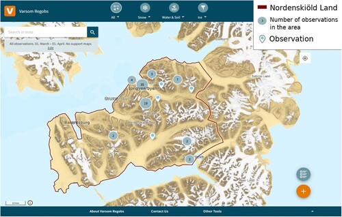
An additional source of information is an avalanche terrain map (see for illustration). Responders on land are called in mostly during snow season, thus they use a publicly available source of information: maps provided by NVE, in cooperation with the NPRA and the Norwegian Meteorological Institute, called Regobs. This is a tool for registering naturally occurring hazards, such as landslides, snow avalanches, floods, and lake ice (Varsom Regobs, Citationn.d.-a). In addition, it shows the steepness of the terrain. Anyone can log an observation into a given mapping platform. Ice and avalanche forecasting are mainly ‘relying on manual observations from the field to assess the stability of the snow' (Participant 2 from Information Support Services, 2022). This platform has several sources of data input and serves diverse purposes, one of which is safe navigation in avalanche terrain.
Figure 2. The extent of observations during 2023 March. Adapted from Varsom Regobs (Citationn.d.-b) and Øien Ørvoll (Citation2019).
An avalanche warning service in Svalbard was launched quite recently and has its limitations. Avalanche forecasting in Svalbard is limited due to a short history of snow observations, with the first official regional warning for avalanches issued only on 21 January 2016 (Engeset et al., Citation2020). Limited records of avalanches along with changing weather patterns contribute to the uncertainty of avalanche forecasting (Hancock et al., Citation2018). Furthermore, initial forecasting lacked the integration of information from different sources and with inadequate placement of the automated snow monitoring systems, it resulted in a failure to predict a snow avalanche in Longyearbyen in 2017 (Hancock et al., Citation2018). This led to placing more monitoring systems in areas where avalanche release threatens infrastructure. While the monitoring systems generate continuous data about snow depth, precipitation, wind, surface temperature, short wave radiation, and soil temperature (Engeset et al., Citation2020), they focus mainly on the exposed infrastructure in and around Longyearbyen, thus are quite static. To complement this, information on snow conditions is also collected through manual observations.
A substantial number of entries in Regobs comes from observers: contractors and private persons (Participant 3 from Information Support Services, 2021). The NVE recruits people who are already aware of safety in an avalanche terrain (Landrø et al., Citation2016). The contractors are given instructions on what information should go into snow observations, with pre-defined routes for observation designed with safety in mind (Participant 2 from Information Support Services, 2022). Thus, making observation capacity dependent on the risk factor. In the case of Svalbard, observations are provided for the Nordenskiöld Land (see ). Observers have seven pre-defined routes for snow monitoring, based on 23 avalanche paths with a focus on the safety of the observers and data collection on snow and avalanches (Engeset et al., Citation2020).
Avalanche terrain observations in Svalbard have limitations. At the beginning of the dark season, there is still not enough snow to use a snowmobile to move around, limiting capacity for observing snow conditions (Participant 2 from Field Operations, 2021). Additionally, not all avalanches are recorded, which might lead to unnecessary confusion. For example, a helicopter was called in three times to check the same avalanche (Participant 1 from Information Support Services, 2022). Furthermore, avalanche terrain varies from valley to valley (Participant 2 from Field Operations, 2021), and limited areal observations result in geographical limitations. For this reason, before going out, volunteers assess the situation with additional information from people who might have observed an avalanche and from their members who frequent surrounding areas (Participant 2 from Field Operations, 2021).
Avalanche maps are assembled through a series of heterogeneous interactions, interlinking safe navigation over the avalanche terrain with the durability and flexibility of these networks. Areal assessments depend on the availability and placement of automated systems; previous knowledge of avalanche events; predefined paths, which in turn are interlinked with knowledge and safety; and the capability to move around the area. Both the production and use of avalanche maps involve navigating between what is evident through maps and the existing knowledge gaps. Placing the monitoring systems, defining observation paths, creating alternative networks for information, and providing accessible visualizations is a matter of integrating new knowledge, sustaining the networks, and reacting to the changes in the surroundings. Thus, assembling avalanche maps requires flexibility and durability.
Local practices
Who will respond to a SAR incident depends on the weather, the relevant proximity to Longyearbyen, and the type of emergency (air, land, or sea). Usually, helicopters are the prime response source. When the police send out a helicopter, they look for information on weather conditions: ‘Weather is always important for our operations' (Participant 1 from Field Operations, 2021). The winter season can be more challenging for air operations, as the police experienced when a whiteout prevented a helicopter from landing (Participant 1 from Field Operations, 2021). This contrasts with the summer season when most people in distress can be reached by helicopter. Therefore, land responses, including voluntary services, are mostly used during the snow season. When a SAR incident happens within reasonable proximity to Longyearbyen, the police mobilize both land and air resources, as illustrated by the incident described in the Introduction.
Mapping platforms used by rescue services on the mainland are not used by their counterparts in Longyearbyen. The police in Svalbard have access to the main mapping platform used by the police service, Telus. It is a digital mapping solution designed specifically for police needs, for example, for coordination between moving vehicles (Participant 4 from Information Support Services, 2022). However, the police in Longyearbyen tend not to use it. One reason might be because the officers in Longyearbyen have only one car (Participant 1 from Field Operations, 2021). With snowmobiles being the main transport mode and mobile coverage being limited to the settlements, tracking the movement of units is neither an option nor a necessity; the operative leader just needs to know that dispatched units have reached their destination (Participant 1 from Field Operations, 2021). Therefore, they opt to use other platforms with other functionalities.
Similarly, volunteers in Longyearbyen use a different mapping platform from the one used by volunteers on the mainland, SARTopo. Volunteers have very specific needs when it comes to maps due to Svalbard’s landscape:
Searching on Svalbard is very different from searching on mainland. Because we don’t have trees. We have very wide and open valleys and we don’t have any vegetation, so […] you will have quite a good sight. (Participant 2 from Field Operations, 2021)
The police in Longyearbyen use several mapping platforms. One of these is preferred for SAR incidents because of integrated sea charts; land maps; a map with registered resources, which can provide rescue services; and a direct communication line with the JRCC, NCG, and NCA (Participant 1 from Operation Coordination, 2021). The platform connects the abovementioned organizations and can be used by coordinators along with responders in the field. However, its use by the field units is limited due to scarce mobile coverage (Participant 1 from Field Operations, 2021). For internal use, the police in Svalbard use an additional mapping platform, which allows for mission planning and prioritizing (Participant 1 from Field Operations, 2021). In addition, the police use expert knowledge collected through experience for assessing where most accidents happen.
Limited mobile coverage challenges coordination between field units and the command post. Instead of using SARTopo with integrated live tracking, which can result in battery drain, volunteers use the tracking feature of their GPS trackers. People at the command post rarely have a good overview of how the teams are moving, especially when trackers stop updating information on responders’ whereabouts: ‘You have to wait until they take the contact back with you. […] the satellite phone most likely will be turned off […] to save battery' (Participant 2 from Field Operations, 2021). A limited inflow of information from the command post leaves communication fragmented and one-sided. At the time of the interviews, volunteers only had three trackers available for their teams. Trackers, like any other professional equipment, are a volunteer organization’s prerogative and depend on the organization’s capability to allocate funds. Therefore, coordination capacity between field units and the command post is limited due to infrastructure and funding availability.
In the field, police responders rely on several maps, their tangibility, and tracklogs. When out on snowmobiles, the police use two pieces of hardware. One gives a larger overview to understand the surroundings, and the second one, with a larger screen, provides access to detailed information necessary for safe navigation: ‘Because, when we are crossing ravines and so on, you have to have a track from whoever rode before you and made it' (Participant 1 from Field Operations, 2021). Access to navigable and informative maps is important also during poor visibility, when track logs can become the only source of navigation, as mentioned by the volunteers: ‘But, of course, in a rescue operation we try to […] we push limits a little bit […] some people, that are very good in driving in bad visibility, and they only drive on their GPS’ (Participant 2 from Field Operations, 2021). While the digital maps provided by the NPI are preferred by rescuers, volunteers find it challenging to get TopoSvalbard maps on certain GPS devices due to software incompatibility (Participant 2 from Field Operations, 2021). In addition to being informative, maps in the field must also be tangible. For example, the hardware used by police officers has buttons, so there is no need for them to remove their gloves and risk freezing their limbs (Participant 1 from Field Operations, 2021). Therefore, the maps used in the field must be navigable and must have storage for track logs and detailed visualization of the surroundings.
To have the most updated information related to navigating in the surroundings, rescue services in Longyearbyen make preparations every year at the beginning of the snowmobile season. The interlocutors mentioned two ways of collecting more data. The first is aimed at the police when they do specific patrols around the most popular routes to record track logs: ‘[G]laciers, they change, over time, rivers change, so the two people in front find the best route and then the third person goes slowly and follows the best route' (Participant 1 from Field Operations, 2021). As shown in the opening quote, the recorded track logs can later be used as the basis for navigation. In addition to making these logs, police are careful to locate and record other changes in the landscape, notably crevasses. Every October they organize helicopter flyovers together with the volunteers over the most used routes, where they look for crevasses. Collected information then is written down and distributed to responders in a form of a list. These preparations are intrinsic to response capacity because they provide the most recent information for navigation along the main routes.
The mapping practices of Norwegian rescue services in Svalbard differ from those on the mainland and rely on different functionalities. Given the specific needs, landscape features, infrastructure, and weather conditions in Svalbard, rescue services do not use the same mapping platforms as their counterparts elsewhere in Norway. Maps, which are widely used by the police (Telus) and by volunteers (SARTopo) cannot offer well-adapted functionalities for Svalbard. For example, they offer tracking capabilities irrelevant to the archipelago due to limited coverage. In the same manner, the command post does not have a full overview of the units in the field, thus hampering situational awareness and coordination. Instead, maps are used mostly for navigation purposes.
The responders in Svalbard have certain practices in place to compensate for the limitations of available mapping platforms. These practices entail complex more-than-human networks, adding to those constituting avalanche and terrain maps. The employment of maps interlinks with the needs of the responders, the available infrastructure, the tangibility of hardware, software restrictions, the specifics of the landscape, the capacity to set up alternative sources for collecting information, and decisions made on the mainland. It is evident that the use of maps as navigation tools is embedded in wider material-semiotic networks, therefore linking safe navigation with the flexibility and durability of these networks.
Concluding discussion
Analyzing maps as processes allowed me to notice the multiple layers of more-than-human interactions enabling maps to function as a navigational aid. Some of these networks are directly involved in assembling maps, such as airplane flyovers or avalanche monitoring systems. Some occur as a proactive action to a lack of information within maps, such as helicopter flyovers or track logging. These practices of assembling maps for their use are directly related to those of producing topographic maps. The multiple temporalities within the assemblages of maps require more-than-human networks to be durable and flexible for maps to assist in navigation.
Furthermore, assembling maps is spatially diverse. The functionalities of maps employed by the Norwegian rescue services in Svalbard are interconnected with what happens on the mainland, from map modelling to decision making regarding which mapping platforms to use. As shown with the NPI example, the production of maps requires the involvement of different institutions for the collection of high-quality topographic data. Additionally, a very important aspect of incident response, timely access to a person in distress, is challenged by changes in the terrain. Thus, responders refer to alternative sources of information to help them safely navigate over the landscape. Avalanche maps are produced by institutions on the mainland, with information inflow from local sources, spreading heterogeneous networks between the mainland and the archipelago. Durability and flexibility of these networks are matters of concern, especially as mapping platforms used on the mainland are not applicable in Svalbard’s settings.
The role of maps as a navigation tool entails continuous proactive more-than-human interactions. Maps are increasingly becoming an integrated action support tool, upon which responders rely, for example, for safe navigation. Therefore, maps must contain the relevant information before an incident happens, to enhance a timely response. However, due to the fluidity of landscape features, this goal is hard to achieve in Svalbard. Gaps are filled in with knowledge collected through more-than-human networks. With the increasingly evident change in weather patterns and the limited predictability of navigation conditions or avalanche forecasting models, the settlement’s capacity for a timely response depends on the flexibility and durability of these networks. The growing inflow of automated data into maps can provide a better overview of the surroundings for navigation safety. However, it is limited by a lack of historical knowledge. Additionally, static automated systems of data provision and the routes of avalanche terrain observations must be up-to-speed with climatic changes. To improve the durability of the networks, long-term solutions, such as knowledge-keeping structures for mapping terrain and related climatic changes, could be developed.
Focusing on maps as processes and going beyond the dichotomy of producing and using maps allows me to notice wider spatial and temporal networks at play. This angle reveals interlinked practices and suggests reasons why they are in place. Although the heterogeneity of mapping assemblages is far from being listed fully, this inquiry reveals the vastness of the networks. In certain cases, the inapplicability of mapping assemblages calls for context-specific solutions. Furthermore, the listed differences in mapping practices underline the complexity of socio-technological assemblages in the Arctic, emphasizing the need for such critical inquiry into the operational capacity of Norwegian rescue services and for further technological development in the region.
Disclosure statement
No potential conflict of interest was reported by the author(s).
References
- Abrahamsson, S., Bertoni, F., Mol, A., & Martín, R. I. (2015). Living with omega-3: New materialism and enduring concerns. Environment and Planning D: Society and Space, 33(1), 4–19. https://doi.org/10.1068/d14086p
- Albrechtsen, E., & Indreiten, M. (2021). Editorial: Arctic safety. Safety Science, 137, 105165. https://doi.org/10.1016/j.ssci.2021.105165
- Andreassen, N., & Borch, O. J. (2020). Co-ordination of emergency response systems in high-complexity environments: Structuring mechanisms and managerial roles. In N. Andreassen, & O. J. Borch (Eds.), Crisis and emergency management in the Arctic (pp. 126–159). Routledge.
- Andreassen, N., Borch, O. J., & Sydnes, A. K. (2020). Information sharing and emergency response coordination. Safety Science, 130, 104895. https://doi.org/10.1016/j.ssci.2020.104895
- Arctic Council. (2011). Agreement on cooperation on aeronautical and maritime search and rescue in the Arctic. Arctic Council Secretariat. http://hdl.handle.net/11374/531
- Barentswatch. (n.d.). [Areal map of northern Norway]. Retrieved September 27, 2023, from https://kart.barentswatch.no/arealverktoy?epslanguage=no
- Christodoulou, A., Dalaklis, D., Raneri, P., & Sheehan, R. (2022). An overview of the legal search and rescue framework and related infrastructure along the Arctic Northeast Passage. Marine Policy, 138, 104985. https://doi.org/10.1016/j.marpol.2022.104985
- Cosgrove, D. (2008). Geography and vision: Seeing, imagining and representing the world. IB Tauris.
- Dalaklis, D., & Drewniak, M. (2020). Search and rescue capabilities in the Arctic: Is the high north prepared at an adequate level? In N. Andreassen & O. J. Borch (Eds.), Crisis and emergency management in the Arctic (pp. 43–60). Routledge.
- Del Casino, V. J. D. C. J. J., Jr. & Hanna, S. P. (2005). Beyond the ‘binaries’: A methodological intervention for interrogating maps as representational practices. ACME: An International Journal for Critical Geographies, 4(1), 34–56. https://acme-journal.org/index.php/acme/article/view/727
- Dodge, M., Perkins, C., & Kitchin, R. (2009). Mapping modes, methods and moments: A manifesto for map studies. In M. Dodge, R. Kitchin, & C. Perkins (Eds.), Rethinking maps: New frontiers in cartographic theory (pp. 220–243). Routledge.
- Duda, P. I., Kelman, I., Glick, N., Sokolenko, V., Poussenkova, N., & Nikitina, E. (2022). Disaster risk perceptions and multinational cooperation in Barentsburg, Svalbard. Polar Record, 58(6), 1–13. https://doi.org/10.1017/S003224742200002X
- Engeset, R. V., Landrø, M., Indreiten, M., Müller, K., Mikkelsen, O. A., & Hoseth, K. I. A. (2020). Avalanche warning in Svalbard (NVE Rapport Nr 35/2020). Norwegian Water Resources and Energy Directorate. https://doi.org/10.25607/OBP-933
- Finnset, K. A., & Thomessen, J. K. (2023, March 11). Skigåer reddet fra Rabotbreen på Svalbard [Skier rescued from the Rabot glacier in Svalbard]. NRK. https://www.nrk.no/tromsogfinnmark/redningsaksjon-etter-skigaer-pa-svalbard-1.16331250
- Fortun, K., Knowles, S. G., Choi, V., Jobin, P., Matsumoto, M., de la Torre, P., Liboiron, M., & Murillo, L. F. R. (2017). Researching disaster from an STS perspective. In U. Felt, R. Fouché, C. A. Miller, & L. Smith-Doerr (Eds.), The handbook of science and technology studies (pp. 1003–1028). The MIT Press.
- Hancock, H., Prokop, A., Eckerstorfer, M., & Hendrikx, J. (2018). Combining high spatial resolution snow mapping and meteorological analyses to improve forecasting of destructive avalanches in Longyearbyen, Svalbard. Cold Regions Science and Technology, 154, 120–132. https://doi.org/10.1016/j.coldregions.2018.05.011
- Hovedredningssentralen. (n.d.). Ansvarsområde [Area of Responsibility]. https://www.hovedredningssentralen.no/om-hrs/ansvarsomrade/
- Hovelsrud, G. K., Veland, S., Kaltenborn, B., Olsen, J., & Dannevig, H. (2021). Sustainable Tourism in Svalbard: Balancing economic growth, sustainability, and environmental governance. Polar Record, 57(47), 1–7. https://doi.org/10.1017/S0032247421000668
- Jasanoff, S. (2017). Science and democracy. In U. Felt, R. Fouché, C. A. Miller, & L. Smith-Doerr (Eds.), The handbook of science and technology studies (pp. 259–287). The MIT Press.
- Jenssen, E. V. (2022). Annual Report 2021. Norwegian Polar Institute. https://hdl.handle.net/11250/3015797
- Johnson, A. (2019). Data centers as infrastructural in-betweens: Expanding connections and enduring marginalities in Iceland. American Ethnologist, 46(1), 75–88. https://doi.org/10.1111/amet.12735
- Justis- og beredskapsdepartementet. (2018). Håndbok for redningstjenesten. Systembeskrivelse – prinsipper – verdier. Nivå 1 [Handbook for the rescue service. System description – principles – values. Level 1]. https://www.hovedredningssentralen.no/wp-content/uploads/2018/09/Den-norske-redningstjenesten.pdf
- Kelman, I., Sydnes, A. K., Duda, P. I., Nikitina, E., & Webersik, C. (2020). Norway–Russia disaster diplomacy for Svalbard. Safety Science, 130, 104896. https://doi.org/10.1016/j.ssci.2020.104896
- Kitchin, R., & Dodge, M. (2007). Rethinking maps. Progress in Human Geography, 31(3), 331–344. https://doi.org/10.1177/0309132507077082
- Kruke, B. I., & Auestad, A. C. (2021). Emergency preparedness and rescue in Arctic waters. Safety Science, 136, 105163. https://doi.org/10.1016/j.ssci.2021.105163
- Kvamstad, B., Fjørtoft, K. E., Bekkadal, F., Marchenko, A. V., & Ervik, J. L. (2009). 2 A case study from an emergency operation in the Arctic Seas. In A. Weintrit (Ed.), Marine navigation and safety of sea transportation (pp. 481–486). CRC Press.
- Landrø, M., Engeset, R., Haslestad, A., Aasen, J., & Orset, K. I. (2016). The Norwegian avalanche observer corps: Safety, quality, training, procedures and culture. In International snow science workshop proceedings (pp. 922–928.
- Latour, B. (1996). On actor-network theory: A few clarifications. Soziale Welt, 369–381. https://www.jstor.org/stable/40878163
- Latour, B. (2005). Reassembling the social: An introduction to actor-network-theory. Oxford University Press.
- Law, J. (2004). After method: Mess in social science research. Routledge.
- Marchenko, N., Andreassen, N., Borch, O. J., Kuznetsova, S., Ingimundarson, V., & Jakobsen, U. (2018). Arctic shipping and risks: Emergency categories and response capacities. TransNav, the International Journal on Marine Navigation and Safety of Sea Transportation, 12(1), 107–114. https://doi.org/10.12716/1001.12.01.12
- Mileski, J., Gharehgozli, A., Ghoram, L., & Swaney, R. (2018). Cooperation in developing a disaster prevention and response plan for Arctic shipping. Marine Policy, 92, 131–137. https://doi.org/10.1016/j.marpol.2018.03.003
- Ministry of Justice and Public Security. (2016). Svalbard–Meld 32 (2015–2016). https://www.regjeringen.no/en/dokumenter/meld.-st.−32-20152016/id2499962/
- Mol, A. (2010). Actor-network theory: Sensitive terms and enduring tensions. Kölner Zeitschrift für Soziologie und Sozialpsychologie, 50(1), 253–269.
- Müller, M., Kelder, T., & Palerme, C. (2022). Decline of sea-ice in the Greenland Sea intensifies extreme precipitation over Svalbard. Weather and Climate Extremes, 36, 100437. https://doi.org/10.1016/j.wace.2022.100437
- Müller, M., & Schurr, C. (2016). Assemblage thinking and actor-network theory: Conjunctions, disjunctions, cross-fertilisations. Transactions of the Institute of British Geographers, 41(3), 217–229. https://doi.org/10.1111/tran.12117
- Norwegian Polar Institute. (n.d.). What we do. https://www.npolar.no/en/about-us/
- November, V., & Créton-Cazanave, L. (2016). Inquiry in control rooms. An analysis through the lenses of space, time and practice. In A. Tapia, P. Antunes, V. A. Bañuls, K. Moore, & J. Porto (Eds.), Proceedings of the 13th international conference on information systems for crisis response and management.
- Øien Ørvoll, O. (2019). Nordenskiöld Land. Norwegian Polar Institute. https://www.npolar.no/nyhet/nordenskiold-land/.
- Perkins, C. (2008). Cultures of map use. The Cartographic Journal, 45(2), 150–158. https://doi.org/10.1179/174327708X305076
- Pyyhtinen, O. (2016). More-than-human sociology: A new sociological imagination. Palgrave Macmillan. https://doi.org/10.1057/9781137531841.0003
- Rossetto, T. (2019). Object-oriented cartography: Maps as things. Routledge.
- Ryghaug, M., Haugland, B. T., Søraa, R. A., & Skjølsvold, T. M. (2022). Testing emergent technologies in the Arctic: How attention to place contributes to visions of autonomous vehicles. Science & Technology Studies, 35(4), 4–21. https://doi.org/10.23987/sts.101778
- Solli, J., & Ryghaug, M. (2014). Assembling climate knowledge. The role of local expertise. Nordic Journal of Science and Technology Studies, 2(2), 18–28. https://doi.org/10.5324/njsts.v2i2.2151
- Statistics Norway. (2023, September 14). Population of Svalbard. https://www.ssb.no/en/befolkning/folketall/statistikk/befolkningen-pa-svalbard
- Sydnes, A. K., Sydnes, M., & Antonsen, Y. (2017). International cooperation on search and rescue in the Arctic. Arctic Review on Law and Politics, 8(0), 109–136. https://doi.org/10.23865/arctic.v8.705
- Sydnes, A. K., Sydnes, M., & Hamnevoll, H. (2021). Learning from crisis: The 2015 and 2017 avalanches in Longyearbyen. Safety Science, 134, 105045. https://doi.org/10.1016/j.ssci.2020.105045
- Tengesdal, S. M., & Kruke, B. I. (2018). Urban avalanche search and rescue operations in Longyearbyen: A study of public-private cooperation. In S. Haugen, A. Barros, C. Gulijk, T. Konsvik, & J. E. Vinnem (Eds.), Safety and reliability–safe societies in a changing world (pp. 407–415). CRC Press.
- Varsom Regobs. (n.d.-a). About Varsom Regobs. https://Regobs.no.
- Varsom Regobs. (n.d.-b). [Map selection from March 1 to April 1, 2023, for Nordenskiöld Land in Svalbard]. Retrieved October 5, 2023, from https://Regobs.no
- Vonderau, A. (2019). Scaling the cloud: Making state and infrastructure in Sweden. Ethnos, 84(4), 698–718. https://doi.org/10.1080/00141844.2018.1471513
- Whatmore, S. (2002). Hybrid geographies: Natures, cultures, spaces. Sage.