Abstract
This paper examines the relative source contribution to ground-level concentrations of carbon monoxide (CO), nitrogen dioxide (NO2), and PM10 (particulate matter with an aerodynamic diameter <10 μm) in a coastal urban area due to emissions from an industrial complex with multiple stacks, quarrying activities, and a nearby highway. For this purpose, an inventory of CO, oxide of nitrogen (NOx), and PM10 emissions was coupled with the non-steady-state Mesoscale Model 5/California Puff Dispersion Modeling system to simulate individual source contributions under several spatial and temporal scales. As the contribution of a particular source to ground-level concentrations can be evaluated by simulating this single-source emissions or otherwise total emissions except that source, a set of emission sensitivity simulations was designed to examine if CALPUFF maintains a linear relationship between emission rates and predicted concentrations in cases where emitted plumes overlap and chemical transformations are simulated. Source apportionment revealed that ground-level releases (i.e., highway and quarries) extended over large areas dominated the contribution to exposure levels over elevated point sources, despite the fact that cumulative emissions from point sources are higher. Sensitivity analysis indicated that chemical transformations of NOx are insignificant, possibly due to short-range plume transport, with CALPUFF exhibiting a linear response to changes in emission rate. The current paper points to the significance of ground-level emissions in contributing to urban air pollution exposure and questions the viability of the prevailing paradigm of point-source emission reduction, especially that the incremental improvement in air quality associated with this common abatement strategy may not accomplish the desirable benefit in terms of lower exposure with costly emissions capping.
The application of atmospheric dispersion models for source apportionment helps in identifying major contributors to regional air pollution. In industrial urban areas where multiple sources with different geometry contribute to emissions, ground-level releases extended over large areas such as roads and quarries often dominate the contribution to ground-level air pollution. Industrial emissions released at elevated stack heights may experience significant dilution, resulting in minor contribution to exposure at ground level. In such contexts, emission reduction, which is invariably the abatement strategy targeting industries at a significant investment in control equipment or process change, may result in minimal return on investment in terms of improvement in air quality at sensitive receptors.
Introduction
Air quality management (AQM) is an integrated approach necessitated by the multidimensional impacts of air pollution on public health, the physical environment, and community welfare (CitationLonghurst et al., 2001; CitationCheung et al., 2005; World Health Organization [WHO], 2006). Despite economic and social considerations, scientific evidence of the contribution of a particular emission source to deteriorated air quality often constitutes the fundamental basis for regulatory decision-making, especially in contexts where several sources with different characteristics contribute to ambient air pollution. As such, establishing adequate spatial and temporal source–receptor relationships conveys a better understanding on what sources need to be targeted for mitigation measures (CitationLaupsa et al., 2009). Although the latter is particularly important from a risk assessment and environmental justice perspective, the fact that higher source emissions is not necessarily associated with higher contribution to ground-level concentrations has driven regulatory agencies to establish standards on ambient concentrations in addition to those on emissions (CitationLeksmono et al., 2006; CitationBehera et al., 2011). For instance, industrial emissions occurring at high release heights experience greater atmospheric dilution capacity than ground-level releases, and thus air quality may not respond any better to costly point-source emission reduction. From a public policy perspective, although the latter has invariably been the obvious abatement strategy targeting industrial activity at a significant investment in control equipment or process change, ground-level area sources require equally closer examination, especially that these are becoming a common occurrence in urban regions, are often close to populated centers, and experience weak atmospheric dispersion leading to elevated exposure levels.
Nevertheless, industrial emissions in urban areas continue to be under scientific scrutiny, given their association with aggravated air quality in these areas (CitationKrishna et al., 2005; CitationEl-Fadel et al., 2009; El-Fadel and Abi Esber, 2012), and their relative contribution to ambient air pollution assists decision-makers in implementing cost-effective management plans (CitationWang et al., 2005). However, working from measured pollutant concentrations at a particular receptor back to emissions requires an understanding of those processes that dictate plume evolution and transport, namely, the release height, meteorological factors, and chemical transformations. As such, source apportionment is not a straightforward activity and several approaches have been adopted to study the relative contribution of emission sources to ambient air pollution. Receptor modeling can be relied upon in such cases (CitationWatson and Chow, 2004) using inverse dispersion modeling, source profiling, principal component analysis (PCA), and chemical mass balance (CMB) approaches. The latter can be resource demanding, are spatially limited to the studied receptor (CitationLaupsa et al., 2009), and exhibit variable degrees of uncertainty (CitationHueglin et al., 2000). On the other hand, emission inventories in conjunction with atmospheric dispersion models are also used in this context (CitationIslam, 1999; CitationCrabbe et al., 2000; CitationFushimi et al., 2005), with the advantage of addressing the critical limitation of low spatial resolution that characterizes air quality monitoring at discrete receptors.
In this context, the current study aims at analyzing source apportionment to ambient air quality in a coastal urban area with emissions from an industrial complex, quarrying activities, and a nearby highway. Emission sources were broadly categorized as elevated point sources (i.e., industries) and ground-level area sources (i.e., highway and quarries) to examine the contribution of each source group to local air pollution in relation to precursor emissions and source characteristics, which therefore reflects on the efficacy of point-source emission control as the most common abatement strategy in mitigating air pollution. For this purpose, an inventory of carbon monoxide (CO), oxide of nitrogen (NOx), and PM10 (particulate matter with an aerodynamic diameter <10 μm) emissions was developed using the U.S. Environment Protection Agency (EPA) EPA-AP42 and European Environment Agency (EEA) emission factor guidelines (CitationEPA, 1994; CitationEEA, 2009). The resulting source emissions were tested for their representativeness by statistical analysis of CALPUFF simulations against year-round field measurements. The emission inventory was then coupled with the non-steady-state Mesoscale Model 5 (MM5)/CALPUFF model to simulate the dispersion of individual source emissions at several spatial and temporal scales. In order to establish the equivalence of two methods in estimating source contribution (namely, “emissions-in” and “emissions-out”), CALPUFF was tested for its sensitivity to input emissions and linearity in responding to changes in emission rates. A sensitivity analysis of CALPUFF simulations to chemical transformations was also conducted. Note that the linearity of CALPUFF in responding to input emissions has not been examined to date, particularly in contexts of short-range regulatory assessments where source groups have different geometry and are spatially stretched leading to rapid plume overlapping.
Methodology
Study area
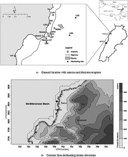
The study area lies along the eastern Mediterranean (latitude 34˚27′N and longitude 35˚34′E), at around 60 km to the north of Beirut City (). The area is urban/semiurban to the west, and rural to the east, with a relatively complex terrain setting (). The general climate is of the subtropical, Mediterranean type with warm and dry summers and falls, and moderately cold and wet winters. The area hosts major cement and fertilizer industries clustered in and around the coastal town of Chekka. The characteristics of the industrial plants are summarized in , including type of activity, production rate, energy source, and reported control measures. Other significant emission sources in the area include vehicular emissions (highway) and quarrying sites. The spatial distribution of the emission sources over the study area, their different geometry, and distance to receptors (monitoring sites) () are likely to lead to complex source–receptor relationships and plume mixing. summarizes the physical characteristics of these sources relative to each other, which reveals that ground-level sources occupy considerable areas as opposed to spatially confined point-source stacks.
Table 1. Characteristics of the main plants in the study areaFootnote a
Table 2. Physical characteristics of modeled source groups
Figure 1. Characteristics of the study area (colour figure avilable in online).
Field measurements
shows the location of the monitoring sites at five towns, namely, Enfeh (LO1), Chekka (LO2), Fih (LO3), Kfarhazir (LO4), and Kefraya (LO5). The terrain elevations show that LO1 and LO2 lie on a flat terrain close to the coastline, whereas LO3, LO4, and LO5 are located in hilly areas at 200 to 400 m above sea level. Ambient concentrations of CO and nitrogen dioxide (NO2) were monitored using an environmental monitoring station (EMS). PM10 readings were recorded using an SKC Split 2 real-time dust monitor. Daily average concentrations of air quality indicators were computed using 30-min or 10-min instantaneous EMS readings and 10-s and 1–5-min average PM10 readings. The field data set was examined for discrepancies that could be attributed to measurement errors. For instance, although CO and NO2 were monitored simultaneously, some NO2 records showing repetitive trends where measurements infrequently meander around a constant value were excluded from the analysis. PM10 measurements were conducted at discrete days during each period. summarizes the monitoring periods at each location along with the total number of daily average records available for statistical analysis upon quality assurance. The periods cover 10 months including the two dominant meteorological regimes of the study area, namely, the warm and dry season that usually spans from May to October, and the wet season that spans from November to April.
Table 3. Summary of field monitoring campaign for CO, NO2, and PM1 0
Model description
The MM5/CALMET/CALPUFF modeling system was used to simulate the dispersion of CO, NOx, and PM10 from various sources. The system is recommended by the EPA for long-range transport regulatory modeling and, on a case-by-case basis for near-field applications where non-steady-state assumptions are significant (CitationEPA, 2008). It includes a meteorological processor (CALMET), a dispersion model (CALPUFF), and a post-processor (CALPOST). CALMET is a diagnostic wind field model with micrometeorological modules for overwater and overland boundary layers (CitationScire et al., 2000). CALPUFF is a multilayer, multispecies non-steady-state Gaussian puff dispersion model that simulates the effects of time- and space-varying meteorological conditions on pollutant transport, transformation, and removal. Unlike traditional Gaussian plume models, CALPUFF simulates the continuous plume from a source as a series of discrete “puffs” (packets of pollutants) (CitationScire et al., 2000) that are transported and dispersed through a three-dimensional wind and micrometeorological field. The CALPUFF system has been applied in contexts of exposure assessments (Macintosh et al., 2010), health impacts (Levy et al., 2002), and source apportionment studies (CitationYim et al., 2010). This study couples the Mesoscale Model 5 (MM5) with CALMET to drive the CALPUFF simulations. Four-kilometer-resolution MM5 data were initially used to generate large-scale wind fields, which were adjusted afterwards using CALMET to reflect the high-resolution terrain and land use data in the area. The meteorological and computational grids were 50 × 50 km with a resolution of 0.5 × 0.5 km. Dispersion options were set to model defaults.
Emission factors
In the absence of representative local emission factors (EFs), ranges of internationally reported values were considered and adjusted to account for case-specific conditions (quality of raw material, processing, and fuel types, etc.) (CitationEl-Fadel and Abi-Esber, 2012; CitationWhyatt et al., 2007). Emission rates (ERs) (mass of pollutant per unit time) were then derived based on the EFs (mass of pollutant per mass or volume of product) and the activity rate (AR) (mass of product per unit time), taking into consideration the percent reduction (R) associated with the presence of control equipment.
summarizes the ranges of emission rates (g/sec) derived for the pollutants (CO, NOx, and PM10) (CitationEl-Fadel and Abi-Esber, 2012). The range of the EPA emission factors (EPA, 1994) was determined depending on the performance of control devices, fuel composition, and source operational characteristics. As such, efficiencies of PM10 control devices were considered to range between 90% and 99% for electrostatic precipitators, 95% and 99% for bag house filters, 75% and 95% for cyclones, and 85% and 97% for wet scrubbers. In the context of emissions from fuel combustion, nitrogen contents ranging from 0.5% to 0.6% (the used range of nitrogen mass content was based on values collected during field interviews with the industries) were assumed for residual oil. CO emission factors were assumed to vary by up to a factor of 10. Average vehicle speeds ranging between 55 and 60 miles per hour were used to determine highway emissions.
Table 4. Range of emission factors (g/sec)
On the other hand, the ranges of EEA emission factors (EEA, 2009) were calculated based on Tier 1 and 2 emission factors and corresponding 95% confidence intervals. The emission factors, which are reported in g/ton of product, were multiplied by the size of production of individual industries (eq 1) to yield a g/sec total emission rate. In cases where emission factors are reported in g/GJ of energy consumed, heat values of 29.3, 45.0, and 32.6 GJ/ton of gas oil, fuel oil, and petcoke, respectively, were used along with the industries' total process fuel consumption to compute emission rates. Whenever Tier 2 emission factors were used, emissions from storage, handling, and transport of product were calculated separately and added to the final emission factor (this type of emissions is implicitly accounted for in Tier 1 emission factors). In the case of cement, lime, and plaster production, 99%, 95%, and 90% reduction in minimum, average, and maximum PM10 emission factors were considered because the EEA emission factors assume that only electrostatic precipitator (ESP) control is in place, whereas field interviews with the industries showed that bag house filters are also being used (CitationEl-Fadel et al., 2009).
Statistical analysis
A total of 13 monitoring periods (see ) coupled with five emission factors (EEAmin, EEAavg, EEAmax, EPAmin, EPAmax) resulted in 65 simulations (13 simulations at each emission factor) and provided sufficient spatial and temporal variability to evaluate the representativeness of each emission factor. As such, model performance at each emission factor was evaluated using several statistical indicators (fractional bias [FB], geometric mean bias [MG], normalized mean square error [NMSE], and the fraction of predictions within a factor of 2 of observations [FAC2]) and data plots correlating model predictions with corresponding field measurements (Chang and Hanna, 2004). FB is a linear measure, and reflects the degree of matching between the predicted and observed mean of the concentration distribution. It ranges between −2 and +2, with a perfect model resulting in FB = 0. MG is also linear, and reflects the degree of bias of the geometric mean rather than the arithmetic mean. A perfect model would result in MG = 1. NMSE measures the relative scatter of the concentration distribution and a perfect model would result in an NMSE = 0. FAC2 is the most robust measure, as it reflects the percentage of predicted concentrations lying within a factor of 2 of observations. Scatter and Q-Q plots were also used to provide visual insight into model's performance. Scatter plots are intended to reveal the scatter about the 1:1 (y = x) line by plotting predicted (y-axis) against the corresponding observed (x-axis) concentrations, which indicates model tendency towards under/overpredictions. Q-Q plots start with the same set of predicted and observed concentrations, but rather ranks these from smallest to greatest so that the 1st, 2nd, …, nth highest predicted concentrations would be plotted against the corresponding 1st, 2nd, …, nth highest observed concentrations, revealing thus model biases in matching the upper end of the concentration distribution. The latter is of particular interest in regulatory contexts of air quality modeling.
Source apportionment
At the estimated emission factors, source apportionment was conducted at various receptors to assess the contribution of each source category to ambient concentrations of air quality indicators at several locations and the likelihood of under/overestimations of source emissions. In the interest of comparative assessment, the sources were categorized as point (Industrial facilities in ) and area (highway and quarrying sites) sources. Source apportionment was conducted by designing a set of emission sensitivity simulations to test the linear response of the model to gross changes in the emission rate (CitationBarna et al., 2006). With the “base-case simulations” at hand (simulations where all source categories were included and considered to be emitting), the contribution of a particular source group to the pollutant concentration at a certain receptor was evaluated in two ways:
| 1. | “Emissions-in” approach: This scenario for a simulation sets the emission rate of all sources to zero, except for the source to be assessed. The contribution of this particular source to the receptor is the predicted concentration. | ||||
| 2. | “Emissions-out” approach: This scenario is the same as the “base case” (all sources emitting), but removes only the emissions from the source to be assessed. The source contribution is thus the difference between the predicted concentration in the “base case” and the predicted concentration in the “emissions-out” simulation. | ||||
This process is intended to test the linearity of the model in responding to changes in precursor emissions, and provides an insight on its response to rescaling of emission factors. In essence, for a given source, the model is assumed to be linear if the predicted concentration contributed by this source is the same when simulated via the two scenarios. In other words, the sum of the concentration predicted in the “emissions-in” and “emissions-out” simulations has to be equal to that predicted in the “base case.” However, this might not be valid for reactive pollutants, which are subject to chemical transformations in the atmosphere that are dependent on their relative ambient mass available for chemical reactions. For this purpose, uncertainty in the results of CALPUFF response to changes in emission rates is also discussed in the context of sensitivity analysis to chemical transformations of NOx to nitrate aerosols. The chemistry model MESOPUFF II scheme within CALPUFF utilizes first-order reaction kinetics for these transformations, and computes daytime and nighttime conversion rates for chemical reactions. The NOx conversion rate is proportional to the ambient ozone concentration and plume NOx concentration, and inversely proportional to a stability index (ranging between 2 and 6 based on five PG stability classes). Due to the lack of ambient ozone concentrations in the study area, model defaults of ozone and ammonia background concentrations (80 and 10 ppb, respectively) were used, and were considered to be uniform throughout the year. As for nighttime conversion rates, model defaults of NOx conversion rate at 2% per hour was used.
The contribution of source groups to the total concentration was evaluated using long-time averages and time series of the 24-hr averages to provide a contribution assessment over finer temporal scales. In a sampling period of more than 1 week, the peak (maximum) week-average concentration was considered. The percent contribution of each source group to this concentration was then calculated to evaluate source contribution at peak levels. Furthermore, one typical time period at each location was analyzed, namely, those where the model exhibited relatively better performance, as these are considered the most reliable for such analysis.
Results and Discussion
Estimation of emission factors
For the purpose of brevity, the current section presents statistical analysis and model performance evaluation at emission factors that showed best correlations with observational data. For instance, CALPUFF simulations using the emission factors EEAmin, EEAavg, and EPAmin exhibited weak agreement with field measurements at all locations and for all indicators. In contrast, simulations using EEAmax exhibited an acceptable match with CO observations most frequently, whereas those with EPAmax matched better with NO2 and PM10 observations. summarizes the statistical analysis of CALPUFF predictions against observations for CO (using EEAmax emission factor) and NO2 (using EPAmax emission factor). Except at LO3 (Fih), the statistical parameters indicate satisfactory to good agreement between simulated and observed CO concentrations. At LO1 (Enfeh), LO2 (Chekka), and LO5 (Kefraya), the FB ranges between 0.04 and 1.2 with an average of 0.24, indicating excellent to acceptable matching of the mean concentration. The average FAC2 value at these locations is 48%, suggesting a reasonable match between predicted and observed concentrations, particularly at LO5 (Kefraya) and LO2 (Chekka) where predictions lie within a factor of 2 of observations for 75% and 67% of the times, respectively. MG and NMSE values further indicate that CALPUFF simulations reproduced measured CO concentrations fairly well, with best MG of 0.97 (perfect value is 1) occurring at LO1 (Enfeh) and best NMSE of 0.3 (perfect value is 0) occurring at LO2 (Chekka). Despite weaker correlations, statistical analysis at LO4 (Kfarhazir) reflects acceptable agreement between CO predictions and corresponding observations, with an overall tendency towards underprediction. NO2 predictions reveal a similar trend, with best matching of observations at LO1, LO2, and LO5, which are the closest locations to the sources (), particularly highway emissions. Simulated NO2 concentrations at LO3 and LO4 show weaker agreement with observations, with a tendency towards underpredictions.
Table 5. Statistical analysis of model simulations against field measurements for CO and NO2
Overall, noticeable matching between predicted and observed CO and NO2 concentrations occurred at LO1, LO2, and LO5 where the source groups considered in model simulations may dominate the contribution to pollutant concentrations, particularly that these are the closest receptors to highway and point-source emissions. On the other hand, weaker correlations occurring at the farther locations (LO4 and LO5) can be attributed to the fact that other unaccounted for sources (domestic generators used during electricity blackouts, arterial roads, open burning of residual waste, etc.) may contribute to significant background concentrations, or otherwise to errors in simulated meteorology. Similarly, summarizes a similar analysis for PM10 predictions. Note that the measured daily average PM10 concentrations were aggregated at each location because these occurred during discrete nonconsecutive days, and then compared with corresponding predictions. Excellent agreement is noticeable at all locations, with FAC2 reaching 100% at LO3, LO4, and LO5, which are the closest locations to quarries (). The FB, MG, and NMSE values at all locations reveal very good model performance in reproducing PM10 measurements at all locations.
Table 6. Statistical analysis of model simulations against field measurements for PM10
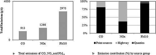
shows typical scatter and Q-Q plots for CO, NO2, and PM10 at selected locations. All scatter plots reveal good model performance, as most predicted concentrations lie within a factor of 2 of observations. Q-Q plots indicate good matching between predictions and observations for the three indicators, particularly in the ability of predicting the peak concentrations, despite the slight underprediction of the peak NO2 concentration. Overall, both scatter and Q-Q plots reveal a tendency towards underprediction of observed concentrations for all indicators (most data points lie below the 1:1 line), but always within acceptable differences (factor of 2 underprediction). The estimated emission factors for the three indicators are presented in Industrial facilities (point sources) accounted for 81%, 37%, and 93% of total CO, NOx, and PM10 emissions, respectively. Highway emissions accounted for the remaining 19% of CO and 67% NOx emissions, and quarries for the remaining 7% PM10 emissions. However, the spatial distribution of sources along with their different geometry (dispersion characteristics) does not allow for correlation between emission magnitudes and contribution to ambient pollutant concentrations.
Figure 2. Selected (a) scatter and (b) Q-Q plots for CO (µg/m3), NO2 (µg/m3), and PM10 (µg/m3).
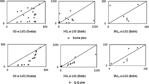
Figure 3. Emission characteristics in the study area.
Emission sensitivity
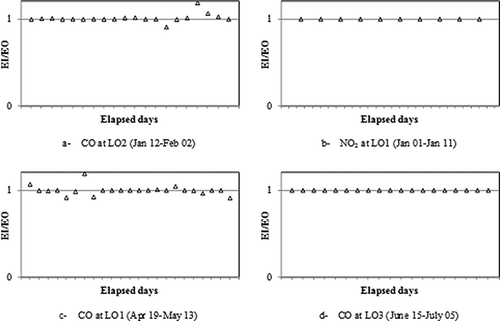
The contribution of highway emissions to CO and NO2 concentrations was calculated through the “emissions-in” (EI), and the “emissions-out” (EO) simulations. To test the linearity of CALPUFF, the ratio of predicted 24-hr average concentrations in the EI simulation to that in the EO simulation is shown in –d, at various receptors and time periods. Clearly, highway contribution to CO and NO2 levels is equivalent in the two scenarios, with a ratio of EI/EO always unity, except for 1 day at LO2 () and 3 days at LO1 (), but with negligible deviation (0.9–1.2). It is worth noting that those days of overprediction of the highway contribution (EI/EO > 1) were characterized by higher wind speeds and less calms frequency, as opposed to days of underpredictions. For instance, the day with underprediction at LO2 was characterized by high percentage of calm hours (11 out of 24) and low average wind speed (0.6 m/sec), which may explain the underestimation of the highway contribution (EI/EO = 0.9) during that day. Days of overpredictions, however, were characterized by zero calm hours and high wind speeds (4.6 m/sec), and CALPUFF overestimated the contribution of the highway. Given the equivalence between the “emissions-in” and the “emissions-out” scenarios, the remaining discussion on source contributions considers the “emissions-out” simulations only.
Figure 4. Ratio of the 24-hr average concentration predicted via the EI and EO scenarios.
Carbon monoxide apportionment
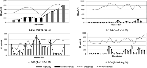
shows the contribution of highway and stack emissions to the maximum weekly average CO concentration at the five locations. At the closest locations LO2 and LO5, highway emissions contributed 96% and 99% of the predicted CO concentrations, respectively, which matched well with the corresponding observed levels. The two source groups contributed almost equally at the northerly and farthest receptors LO1 and LO3, with noticeable underprediction of the weekly average CO concentration at LO3. At LO4, highway emissions accounted for 77% of the predicted concentration, which was around a factor of 3 less than the observed level.
Table 7. Source contribution to the highest weekly average CO concentration
shows time series of the daily contribution of highway and point-source emissions to the CO concentration at several locations. Simulated CO levels matched relatively well the observations at LO1 and LO2 (within a factor of 2) (–b), with underprediction when stack emissions dominated or contributed significantly to the CO concentration. For instance, underprediction can be noted during the first week in the simulated period at LO1 () and the last week at LO2 (), where stack emissions contributed 65–80% and 40–60%, respectively. Furthermore, at LO3 (), CALPUFF underestimated the maximum 24-hr average CO concentration for the entire simulated period. Note that point sources accounted for around 85% of the predicted concentration during some days (June 25–26), and for 54% of the highest weekly average. On the other hand, predicted concentrations were relatively closer to observations when highway emissions dominated the contribution to CO levels, namely, the second half of the simulated period at LO3 where the highway accounted for 45–70% of predicted concentration. LO4 reveals a similar trend (), with underpredictions of the 24-hr average concentration when point sources dominated the contribution, namely, the 1st week of the simulation period (). However, highway emissions dominated the contribution to CO levels at this receptor, reaching up to 95% at some days, and where CALPUFF predictions matched well the magnitude and temporal pattern of observations (less than a factor of 2 underprediction). At LO5, highway emissions contributed 100% of the predicted concentration for all days, with overpredictions of the observed concentration, and thus was excluded from further analysis. In essence, underpredictions of the observed CO concentrations are noticeable at LO3 and LO4, which can be attributed to underestimation of CO emissions from point sources. Also, vehicular emissions are significant contributors to the CO concentration in the study area, with this contribution decreasing at farther locations.
Figure 5. Typical daily source contribution to CO concentration (µg/m3) at several locations.
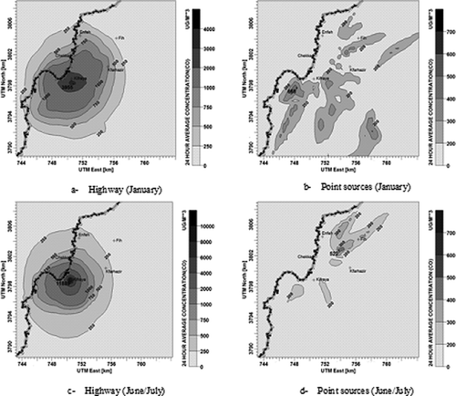
To provide a contribution assessment over the entire area, shows contour lines delineating CO levels contributed by highway and point-source emissions separately, during 2 months of the year. The highest 24-hr average CO concentration contributed by highway emissions increased by around a factor of 3 during summer (3955 µg/m3 during January vs. 11,889 µg/m3 during July), but occurred at the same location, close to LO5. Also, summer times were characterized by higher near-source accumulations (), primarily due to the frequent occurrence of stagnation hours. For instance, LO1 and LO4 (relatively distant receptors from highway emissions) witnessed CO levels of 500 and 750 µg/m3 during winter (), respectively, as opposed to lower levels (250 µg/m3) during the summer (). Highway emissions were thus transported to farther locations during winter times, but always with concentrations lower than the ambient air quality standard. On the other hand, the peak 24-hr average CO concentration contributed by point sources decreased from 668 µg/m3 during winter to 522 µg/m3 during summer (–d). Furthermore, winter times were characterized by larger areas affected by higher CO exposure albeit lower than the standard.
Figure 6. Spatial distribution of the 24-hr average CO concentration during winter and summer (colour figure avilable in online).
Nitrogen dioxide apportionment
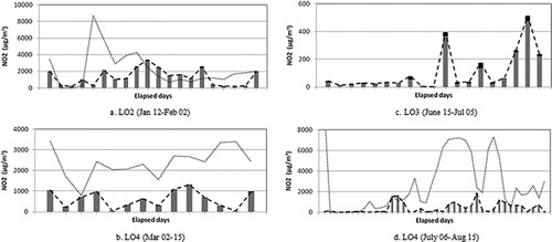
summarizes the contribution percentages of highway and stack emissions to NO2 concentration at the five locations, indicating the prevalence of highway emissions (ranging between 87% and 100%) on the simulated NO2 concentration. Significant underprediction of the observed concentration is noticeable at LO1 and LO3. The contribution of the two categories to daily NO2 concentration is shown in –d. The predicted 24-hr average concentration matched well observations at LO2, except for 2 days (January 16–17), when underprediction is evident (). Highway emissions accounted for around 95% of the NO2 concentration at this receptor for all days. At LO4 (March 2–15) (), CALPUFF underpredicted the observed concentration (a factor of 3), but was able to reproduce the temporal trend over the time period. Highway contribution prevailed also at this receptor, with a percentage of >95%. At LO3, point sources contributed up to 36% during some days (), but with significant underpredictions of observations (2–3 orders of magnitude), which are hence not included. Although this could be attributed to underestimation of emissions from point sources, there remains the possibility that other potential unaccounted-for sources in the simulations (domestic heating/generators, arterial roads, open burning, etc.) are contributing to such elevated concentrations. Furthermore, CALPUFF generally captured the temporal fluctuation in the concentration distribution at this receptor (LO3), indicating that a higher emission rate would result in better matching of observed concentrations. During another period at LO4 (), the simulated concentration was 5 times less than the observed, with highway emissions dominating the contribution (90%), except for July 10–14, when point sources contributed ∼35%.
Table 8. Source contribution to the highest weekly average NO2 concentration
Figure 7. Typical daily source contribution to NO2 concentration at several locations.
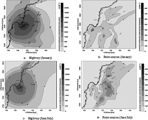
The spatial distribution of NO2 levels contributed by the two categories is shown in Summer times were characterized by higher accumulation of NO2 concentration. Peak concentrations contributed by point sources increased during summer and occurred at a different location (southwest in winter and north in summer) (–d). Also, larger areas were affected by point-source emissions during summer, with relatively higher concentrations. In contrast, highway emissions contributed to larger areas during the winter, indicating longer transport distances. The peak concentration occurred at the same location near LO5, and increased by slightly more than a factor of 2 in the summer.
Figure 8. Spatial distribution of the 24-hr average NO2 concentration during winter and summer (colour figure avilable in online).
Particulate matter apportionment
Sources contributing to PM10 emissions are area sources (quarrying sites) (197 g/sec) and point sources (2773 g/sec), accounting for 7% and 93% of total emissions (2784 g/sec), respectively. Measurements of ambient PM10 concentrations covered 1–2 days at a receptor. The corresponding contribution of each source category to PM10 levels was examined in the context of spatial analysis of the concentration distribution. The analysis considered one period of the year to reflect on the contribution magnitude of each source category, rather than the spatial distribution (areas affected), which is expected to have similar patterns as that of NO2. shows contour lines of PM10 levels in the study area contributed by point and area sources during summer times (July), which revealed high accumulation levels.
Figure 9. Spatial distribution of the 24-hr average PM10 concentration during summer (colour figure avilable in online).
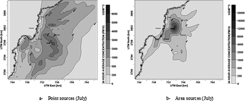
Emissions from point sources affected almost all the study area, with concentrations exceeding the 24-hr average standard, with inner areas witnessing higher PM10 levels than coastal ones (). The peak 24-hr average concentration contributed by point sources reached 4186 µg/m3 south of LO4. On the other hand, emissions associated with quarrying (area sources) affected a smaller part of the study area, albeit higher accumulation levels near the sources with peak concentration reaching 17,700 µg/m3 close to the CN quarry, indicating weak dispersion and shorter transport.
Chemical transformations
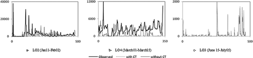
shows time series of the 1-hr average NO2 concentration at several locations simulated with and without considering chemical transformations. Although time series of both underpredicted observed NO2 concentrations, particularly at LO3 (several orders of magnitude and hence not included), they coincided with each other, indicating little to no NOx reactions. Only at LO3 (), simulated NO2 concentrations decreased slightly when chemical transformations (CT) were incorporated, reflecting the significance of longer transport distances on inducing chemical reactions. Note that the statistical parameters calculated upon simulating chemical transformations, and the spatial distribution of the NO2 concentration, exhibited no significant differences compared with base-case simulations.
Figure 10. Time series of NO2 concentration with and without chemical transformations.
Conclusion
The non-steady-state CALPUFF model was coupled with an emission inventory for source apportionment to CO, NO2, and PM10 levels at several locations in an urban industrial area encompassing emissions from a multistack complex, a highway, and quarrying sites. CALPUFF was tested for its linear response to changes in emissions, and exhibited equivalence in simulating the contribution of a source category using two approaches, namely, the “emissions-in” and “emissions-out” scenarios, which indicates that the model adds the contributions from each source category to the pollutant concentration at a receptor. Source apportionment revealed that ground-level releases (i.e., highway and quarries) extended over large areas dominated the contribution to ambient concentrations of CO, NO2, and PM10 at close locations to the sources, despite the higher cumulative emissions from point sources, indicating that releases at elevated heights experience adequate dilution. Near the highway and quarries, significant accumulation is noticeable during summer times compared with winter times due to higher frequency of calm conditions and unfavorable meteorology, with point sources affecting distant areas the most, but with lower exposure levels compared with area sources. The latter results point to the significance of ground-level area sources in contributing to elevated exposure levels in urban areas and that such sources should be equally targeted for management options. Equally important, the results raise questions in relation to the viability of the prevailing paradigm of point-source emission reduction that encompass excessive costs with little return on investment measured as improvement in air quality or decreased exposure per unit cost invested. To this end, sensitivity analysis to chemical transformations, although limited by the use of model defaults of background ozone and ammonia concentrations, revealed that these were insignificant and subsequently had little effect on the linear response of CALPUFF to NOx emissions, possibly due to short-range plume transport within the study area. Note that for industry-specific pollutants that constitute markers for certain industries and that are not commonly emitted from open area/ground-level sources in urban settings, point-source emission reduction remains the critical abatement measure, with source apportionment becoming of less significance.
Acknowledgment
The air quality and meteorology database was collected by the Lebanese American University (LAU) under a grant from the United States Agency for International Development (USAID). Special thanks are extended to Drs. Gebran Karam and Mazen Tabbara at LAU for making the database available.
References
- Barna , M.G. , Schichtel , B.A. , Gebhart , K.A. and Malm , W.C. 2006 . Modeling regional sulfate during the BRAVO study: Part 2. Emissions sensitivity simulations and source apportionment . Atmos. Environ. , 40 : 2423 – 2435 . doi: 10.1016/j.atmosenv.2005.12.038
- Behera , S.N. , Sharma , N. , Dickshit , O. and Shukla , S.P. 2011 . GIS-based emission inventory, dispersion modeling, and assessment for source contributions of particulate matter in an Urban Environment . Water Air Soil Pollut. , 218 : 423 – 436 . doi: 10.1007/s11270-010-0656-x
- Cheung , H.C. , Wang , T. , Baumann , K. and Guo , H. 2005 . Influence of regional pollution outflow on the concentrations of fine particulate matter and visibility in the coastal area of southern China . Atmos. Environ. , 39 : 6463 – 6474 . doi: 10.1016/j.atmosenv.2005.07.033
- Crabbe , H. , Beaumont , R. and Norton , D. 2000 . Assessment of air quality, emissions and management in a local urban environment . Environ. Monit. Assess. , 65 : 435 – 442 . doi: 10.1023/A:1006481229246
- El-Fadel , M. and Abi-Esber , L. 2012 . Simulating industrial emissions using ADMS4: Model performance and source emission factors . J. Air Waste Manage. Assoc. , 62 : 336 – 349 . doi: 10.1080/10473289.2011.651556
- El-Fadel , M. , Abi-Esber , L. and Ayash , T. 2009 . Managing emissions from highly industrialized areas: Regulatory compliance under uncertainty . Atmos. Environ. , 43 : 5015 – 5026 . doi: 10.1016/j.atmosenv.2009.06.056
- European Environment Agency . 2009 . EMEP (Cooperative Programme for Monitoring and Evaluation of the Long-Range Transmission of Air Pollutants in Europe)/EEA (European Environment Agency) Air Pollutant Emission Inventory Guidebook 2009. Technical Guidance to Prepare National Emission Inventories , Copenhagen : EEA . EEA Technical Report No. 9/2009
- Fushimi , A. , Kawashima , H. and Kajihara , H. 2005 . Source apportionment based on an atmospheric dispersion model and multiple linear regression analysis . Atmos. Environ. , 39 : 1323 – 1334 . doi: 10.1016/j.atmosenv.2004.11.009
- Hueglin , C. , Devos , W. , Gehrig , R. , Hofer , P. , Kobler , J. , Stahel , W.A. , Wolbers , M. , Baltensperger , U. and Monn , C. 2000 . Source apportionment of PM10 in Switzerland by application of a multivariate receptor model . J. Aerosol Sci. , 31 : 891 – 892 . doi: 10.1016/S0021-8502(00)90901-7
- Islam , M.A. 1999 . Application of a Gaussian plume model to determine the location of an unknown emission source . Water Air Soil Pollut. , 112 : 241 – 245 . doi: 10.1023/A:1005047321015
- Krishna, T.V., M.K. Reddy, and R.C. Reddy. 2005. Impact of an industrial complex on the ambient air quality: Case study using a dispersion model. Atmos. Environ. 39:5395–5407. Doi http://dx.doi.org/10.1016/j.atmosenv.2005.06.003 (http://dx.doi.org/10.1016/j.atmosenv.2005.06.003)
- Laupsa , H. , Denby , B. , Larrsen , S. and Schaug , J. 2009 . Source apportionment of particulate matter (PM2.5) in an urban area using dispersion, receptor and inverse modeling . Atmos. Environ. , 43 : 4733 – 4744 . doi: 10.1016/j.atmosenv.2008.07.010
- Leksmono , N.S. , Longhurst , J.W.S. , Ling , K.A. , Chatterton , T.J. , Fisher , B.E.A. and Irwin , J.G. 2006 . Assessment of the relationship between industrial and traffic sources contributing to air quality objective exceedences: A theoretical modelling exercise . Environ. Model. Softw. , 21 : 494 – 500 . doi: 10.1016/j.envsoft.2004.07.012
- Longhurst , J. W. , Beattie , C.I. and Woodfield , N.K. 2001 . Air quality management: Evolution of policy and practice in the UK as exemplified by the experience of English local government . Atmos. Environ. , 35 : 1479 – 1490 . doi: 10.1016/S1352-2310(00)00311-3
- Scire , J.S. , Strimaitis , D.G. and Yamartino , R.J. 2000 . A User's Guide for the CALPUFF Dispersion Model , Concord , MA : Earth Tech Inc .
- U.S. Environmental Protection Agency . 1994 . Compilation of Air Pollutant Emission Factors, AP-42 , 5th , Research Triangle Park : Office of Air Quality Planning and Standards, Emission Inventory Branch, U.S. Environmental Protection Agency .
- U.S. Environmental Protection Agency . 2008 . Clarification of Regulatory Status of CALPUFF for Near-Field Applications , Research Triangle Park , NC : U.S. Environmental Protection Agency .
- Wang , X. , Carmichael , G. , Chen , D. , Tang , Y. and Wang , T. 2005 . Impacts of different emission sources on air quality during March 2001 in the Pearl River Delta (PRD) region . Atmos. Environ. , 39 : 5227 – 5241 . doi: 10.1016/j.atmosenv.2005.04.035
- Watson , J.G. and Chow , J.C. 2004 . Receptor models for air quality management . EM , 10 : 15 – 25 .
- Whyatt , J.D. , Metcalfe , S.E. , Nicholson , J. , Derwent , R.G. , Page , T. and Stedman , J.R. 2007 . Regional scale modeling of particulate matter in the UK, source attribution and an assessment of uncertainties . Atmos. Environ. , 41 : 3315 – 3327 . doi: 10.1016/j.atmosenv.2006.12.040
- World Health Organization . 18–20 October 2005 2005 . WHO Air Quality Guidelines Global Update 2005. Report on a working group meeting , 18–20 October 2005 , Bonn , , Germany : World Health Organization .
- Yim , H.L. , Fung , C.H. and Lau , K.H. 2010 . Use of high-resolution MM5/CALMET/CALPUFF system: SO2 apportionment to air quality in Hong Kong . Atmos. Environ. , 44 : 4850 – 4858 . doi: 10.1016/j.atmosenv.2010.08.037