
Abstract
The procedure of a multi-criteria decision analysis supported by the geographic information systems was applied to the site selection process of a planning municipal solid waste management practice based on twelve different scenarios. The scenarios included two different decision tree modes and two different weighting models for three different area requirements. The suitability rankings of the suitable sites obtained from the application of the decision procedure for the scenarios were assessed by a factorial experimental design concerning the effect of some external criteria on the final decision of the site selection process. The external criteria used in the factorial experimental design were defined as “Risk perception and approval of stakeholders” and “Visibility”. The effects of the presence of these criteria in the decision trees were evaluated in detail. For a quantitative expression of the differentiations observed in the suitability rankings, the ranking data were subjected to ANOVA test after a normalization process. Then the results of these tests were evaluated by Tukey test to measure the effects of external criteria on the final decision. The results of Tukey tests indicated that the involvement of the external criteria into the decision trees produced statistically meaningful differentiations in the suitability rankings. Since the external criteria could cause considerable external costs during the operation of the disposal facilities, the presence of these criteria in the decision tree in addition to the other criteria related to environmental and legislative requisites could prevent subsequent external costs in the first place.
Implications:
An experimental design was applied to a siting process based on different scenarios. The suitability rankings of suitable sites were obtained for each scenario. The external criteria used in the design were defined as perception and visibility. The presence of the external criteria produced meaningful differentiations. Two widespread persuasions about site selection were disproved using the results.
Introduction
Total social cost of an economic activity, which can be defined as the sum of all the costs associated with the activity, includes the private and external costs of the activity (CitationDijkgraaf and Vollebergh, 2004). External costs (externalities), on the other hand, could be defined as the sum of the costs (negative externalities) and the benefits (positive externalities) realized when an economic activity of one group has an impact on another (CitationEshet et al., 2006).
Each of the waste disposal methods has some externalities in different forms and levels. These externalities are affected by a number of variables, including waste composition, type of the disposal method, the location of disposal site, legal limitations, and so on. The main factors that generate the negative externalities arising generally from collection and transportation of the wastes and operation of the disposal facilities may be classified as (1) emissions to air, soil, and water bodies, and (2) disamenities (CitationEshet et al., 2007a).
It is widely accepted that externalities can be conceptually split into fixed and variable costs and benefits. In waste management, the term “fixed externality” refers to the externalities that arise from the mere existence of a disposal process. Such fixed costs should be calculated for each site and should relate to the existing distribution of households around a site. In the context of landfills, such costs should therefore be independent of the size of the landfill (area or stock capacity), the amount of waste it receives (flow volume), and possibly the type of waste it receives (inert, biodegradable, or hazardous). The term “variable externality,” on the other hand, refers to the externalities that depend on the type and amount of waste going to a landfill. Most waste externalities such as emissions to air, water, and soil bodies are variable external costs, but the disamenities are mostly fixed externalities (Defra, 2003).
The nature of the negative externalities caused by the disamenities related to incinerators and landfills shows similarities to a great extent, although there are some basic differences between them. CitationJamasb and Nepal (2010) state that the role of the externalities resulting from disamenities in the total social cost is about 10% for incineration and 25% for landfilling. The amount of this externality is generally affected by factors including odor, fly ash, litter, noise, traffic, visibility, and so on (CitationEshet et al., 2007a). The disamenities and related externalities vary depending on the level of risk perception in the public, which is closely related to being visible for settlers (CitationEshet et al., 2007b; CitationJamasb and Nepal, 2010). Therefore, the risk perception and the factors leading to this perception, such as visibility (CitationKontos et al., 2005), determine levels of the externalities that will be caused by the disposal facility in the future. In this context, it can be said that the externalities arising from disamenities are directly related to the site selection procedure of the disposal facilities. Hence the methods to prevent the externalities in the first step, that is, site selection, should be preferred to paying compensatory funds (CitationChiueh et al., 2008) to overcome the oppressions related to the negative perceptions emerging after the facility is constructed and starts to operate.
In recent years, selection of a suitable site for a disposal facility is generally performed by simultaneous use of geographic information systems (GIS) and multicriteria decision analysis (MCDA) methods (CitationAl-Yaqout et al., 2002; CitationVaillancourt and Waaub, 2002; CitationNa et al., 2007; CitationChang et al., 2008; CitationSharifi et al., 2009; CitationWang et al., 2009; CitationAragonés-Beltrán et al., 2010; CitationDe Feo and De Gisi, 2010; CitationMoeinaddini et al., 2010; CitationGorsevski et al., 2012). However, only a few of these studies considered the factors leading to externalities such as negative risk perception (CitationAl-Yaqout et al., 2002; CitationVaillancourt and Waaub, 2002; CitationNa et al., 2007; CitationChang et al., 2008; CitationCheng et al., 2002) and visibility (CitationKontos et al., 2003; CitationKontos et al., 2005; CitationAragonés-Beltrán et al., 2010; CitationGeneletti, 2010; CitationMoeinaddini et al., 2010; CitationTavares et al., 2011; CitationZelenovic Vasiljevic et al., 2012). The externalities that could arise from unsuitable site selection were generally omitted in most of the studies, and there is also no investigation in the literature that clarifies how the final decision of the site selection procedure is effected by external criteria. Therefore, probable effects of the omission of the externalities on the final decision of the site selection procedure should be investigated in details with respect to the whole waste management practice.
In this study, the effects of some external criteria on the final decision are investigated by a factorial experimental design. The external criteria considered in the study were selected as “risk perception and approval of stakeholders” and “visibility” due to the possibility that they could create some external costs after the disposal facility is built and started to operate. The suitability rankings produced by the default decision tree (i.e., the structure without external criteria) and those produced by the structure with external criteria were compared by the statistical methods of analysis of variance (ANOVA) and Tukey tests, and the extent of the differentiations is discussed in detail.
Material and Methods
A real-life study was conducted to assess the effects of the external criteria on the final decision of a site selection process (i.e., suitability ranking). The results of area requirements obtained by CitationKorucu et al. (2013b) for a real municipal solid waste disposal problem, which includes the determination of types of the disposal facilities and corresponding area requirements, were used as the reference data. The details of the decision tree with three phases (i.e., “Phase_1,” “Phase_2,” and “Phase_3”) used for the determination of suitable sites for disposal facilities were given in CitationKorucu and Erdagi (2012), while the details of the site selection procedure with GIS were given in CitationKorucu et al. (2013a).
Area requirements and site selection procedure
A cost optimization study was conducted by CitationKorucu et al. (2013b) to determine the disposal methods to be used for the disposal of municipal solid wastes produced within the period of 2015–2040 in Kocaeli, Turkey. The study showed that a management model including one incinerator and two landfills would be the optimum solution for handling the municipal solid wastes of Kocaeli. The minimum area requirements for these facilities were determined as 15 acres for incinerator, and 250 and 500 acres for the landfills. Therefore, all the assessments presented in this study are made based on these three different area requirements.
In this study, the first phase of the site selection procedure (“Phase_1”) proposed by CitationKorucu and Erdagi (2012) was applied to two different buffering modes of the decision tree: “Legislation” mode, which satisfies the buffering conditions obliged only by the Turkish environmental regulations, and “Proposed” mode, which satisfies new additional conditions proposed by CitationKorucu and Erdagi (2012). The counts and the locations of suitable areas were determined by the processes of buffering and the elimination of unsuitable areas with GIS for each mode separately. These applications were called “Section_1” in this study.
The suitable areas obtained for “Section 1” were put in a suitability ranking by the application of “Phase_2” with GIS. “Phase_2” application was performed for two different criteria weights: the weights determined by a decision-making team, which were called the “Table,” and the weights taken as equal for all criteria, which were called “Equal.” As a consequence of these applications performed for each area requirement (i.e., 15, 250, and 500 acres), 12 different scenarios results were obtained in total (15_Legislation_Equal, 15_Legislation_Table, 15_Proposed_Equal, 15_Proposed_Table, 250_Legislation_Equal, 250_Legislation_Table, 250_Proposed_Equal, 250_Proposed_Table, 500_Legislation_Equal, 500_Legislation_Table, 500_Proposed_Equal, 500_Proposed_Table). These applications were called “Section_2” in this study.
Factorial experimental design
This study includes the utilization of aforementioned two sections (“Section_1” and “Section_2”) to observe possible effects of the external criteria on the final decision for 12 different scenarios. For this purpose, the whole of “Section_2” was separately structured by a factorial experimental design for the all scenarios, and differentiations in the suitability rankings caused by the external criteria were tested.
In the application of the factorial experimental design, the criteria with the highest weight value in each main criteria group (i.e., public health and safety criteria group, economical criteria group and social criteria group) were defined as “main factors.” These main factors are “distance from residential areas” (in public health and safety criteria group), “proximity to customers” (in economical criteria group), and “risk perception and approval of stakeholders” (in social criteria group), according to CitationKorucu et al. (2013a). Among them, the criterion of “risk perception and approval of stakeholders” could directly cause externalities in the management process. However, since mapping of this criterion is determined by the subjective conditions of the residents (CitationLober, 1995), it could show significant differences with time and the changes in the administrative conditions. Therefore, an additional criterion, “visibility,” which can also be assessed as an external criterion, was added to the structure to be used in the factorial experimental design. The maps showing the site selection layers formed for the four criteria that were determined as the “main factors” in the factorial experimental design are given in to . The details related to these criteria are given next:
Figure 1. Map of the criterion of “distance from residential areas.”
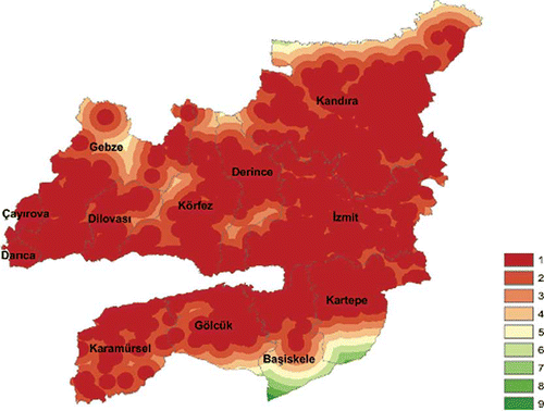
Figure 2. Map of the criterion of “proximity to customers.”
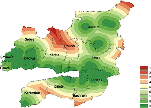
Figure 3. Map of the criterion of “risk perception and approval of stakeholders.”
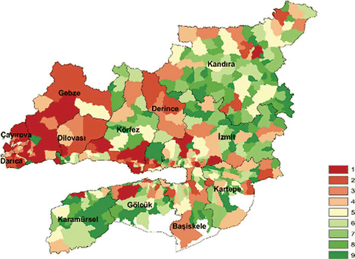
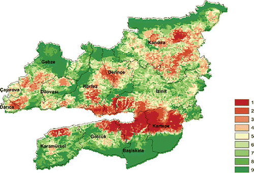
Figure 4. Map of the criterion of “visibility.”
Distance from residential areas
This is the layer obtained from the weighting of the distances from the large public places, urban study areas, nonresidential study areas, auxiliary business centers, central business areas, existing urban and rural residential areas together with the parks and gardens, and the residential areas with different densities (i.e., very low, low, medium and high) that are planned to be built in the near future (the most distant grids were weighted as 9, and the nearest grids were weighted as 1).
Proximity to customers
This is the layer obtained from the weighting of the proximity to the sites where customers and/or suppliers for the valuable materials recycled from the solid wastes are present, including storage areas, industrial areas in different scales, free zones, technology development areas, wastewater treatment plants and solid waste collection centers, and so on (the nearest grids were weighted as 9, and the most distant grids were weighted as 1).
Risk perception and approval of stakeholders
This is the layer obtained from the weighting of distances from the areas with a high population density, based on the hypothesis that risk perception would be highly negative in the areas with high population (the nearest grids to the most crowded areas were weighted as 1, and the nearest grids to the least crowded areas were weighted as 9).
Visibility
This is the layer obtained from the weighting of the visibility of the disposal sites at a distance up to 3 km from the residential areas (it was defined as the visibility of a 5-m-high waste dump by a person standing on a 30-m-high building as the person turns around his or her own axis by 360 degrees with a visual angle between +45 and –45 degrees from the person's eye level) (the grids that could not be seen from any residential area were weighted as 9, and the grids that could be seen easily from the most of the residential areas were weighted as 1).
Since the number of factors to be used in the factorial experimental design is 4 (“Distance from residential areas,” “Risk perception and approval of stakeholders,” “Proximity to customers” and “Visibility”), there should be a design including 42 experiments (or structure) when it is formed in two different levels of use (+) and nonuse (–) of these factors in the GIS-supported site selection process. The structures and the interaction types of these experiments are given in .
Table 1. The main factors, interactions, and the configuration of factorial experimental design used in the study
The structure “A” in is the structure where all main factors were used in the site selection procedure, and it was the only structure used by CitationKorucu et al. (2013a). In this study, the experiments were additionally performed by using all the structures given in for 12 different scenarios separately. A random code was given to each parcel of the “suitable areas” obtained from the “Section_1” applications before these experiments. These areas were divided into the grids with a resolution of 10 × 10 m. A suitability value was obtained for each suitable area by application of “Section_2.” Then the suitability values were organized in descending order. An example of the rankings based on the suitability values is given in .
Table 2. Suitability rank of the parcel codes produced by 16 different experimental designs for the scenario of “250_Legislation_Table”
Statistical analysis of suitability rankings
Based on the results of the experiments performed for each scenario, a statistical analysis was conducted to observe how the main factors change the suitability rankings. In order to assess the degree of changes observed in the experiments separately in relation to each other, the structure “P” in , where none of the main factors is included in the site selection procedure, was taken as reference. The data related to the rankings given in were normalized to make a statistical comparison based on “P” reference structure. In this application, parcel code was marked as “1” (which means that no change was observed) if it was the same as the corresponding parcel code in the “P” structure. It was marked as “0” (which means that a little change was observed) if it was the same as any parcel code in the “P” structure other than the corresponding parcel code. It was marked as “–1” (which means that a significant change was observed) if it was not the same as any parcel code in the “P” structure. This procedure was applied to all the structures from “A” to “P,” which constitutes an experimental design set, and all the values in the reference “P” structure were assigned certainly as “1.” shows the result of this normalization procedure applied to .
Table 3. Normalized values of “250_Legislation_Table” scenario
Tables of the suitability rankings produced for 12 different scenarios just like were reorganized separately based on the aforementioned normalization procedure to obtain a table similar to for each scenario. A variance analysis (one-way ANOVA) on Excel was used to determine the experimental design sets with meaningful differentiations. All of the experimental design sets were determined as significant because their F values were higher than the F-critical value (1.74).
Since ANOVA could not order the experiments according to the level of differentiations, the Tukey test was applied to assess the level of differentiations as a post hoc test. The test was applied to all the experiment design sets by an open-source XL Toolbox application that could be performed in Excel. The q values obtained for the reliability level of 95% in Tukey tests were ordered and all the experiments with a q value higher than q-critical were accepted as the experiments causing a meaningful differentiation in the experiment set. In this regard, the experiment with the highest q value should necessarily be the experiment causing the highest differentiation. As an example, the results obtained by the application of this procedure to the minimum area requirement of 250 acres are presented in . As shown in , for the “250_Legislation_Equal” scenario, structure “A” showed the highest differentiation in the suitability ranking with respect to that of the reference structure “P,” while structure “L” showed the lowest differentiation. On the other hand, the differentiations caused by the structures “H,” “E,” and “N” were not found to be statistically significant.
Table 4. Results of one-way ANOVA followed by Tukey test for the area requirement of 250 acres
In the studies of the factorial experimental design, the main factors were represented by the structures “O” (distance from residential areas), “N” (proximity to customers), “L” (risk perception and approval of stakeholders), and “H” (visibility) in the experimental design set. Additionally, the structures “D,” “F,” “G,” “J,” “K,” and “M” represent the dual interactions of these four main factors in the experimental design. Similarly, the structures “B,” “C,” “E,” and “I” represent the triple interactions, and the structure “A” represents the quadruple interaction (see ). Since it requires a detailed statistical analysis to determine which main factor, and to what extent, causes the differentiations in each interaction, it was assumed that the differentiations were caused by all the factors in all interactions equally. In this manner, the experimental sets include 15 experimental structures composed of four main factors, six dual interactions, four triple interactions, and one quadruple interaction. Another normalization process was applied to order the differentiation effects of these 15 experimental designs on the results. In order to do this, the q values obtained for the experiments were organized in descending order (impact order). Then an impact level value (ILV) of 15 was assigned to the structure with the highest q value, and it was decreased correspondingly with the q values (14 to the structure with the second highest q value, etc.). The sum of the ILVs was defined as the total impact value (TIV) for the corresponding scenario, and a normalized impact value (NIV) of each experiment was assigned in percentage based on TIV.
All in all, the overall methodology used in the study can be summarized as follows:
| 1. | “Section_1”: The counts and the locations of suitable areas for each area requirement (i.e., 15, 250, and 500 acres) were determined by the processes of buffering and the elimination of unsuitable areas using a geographic information system (GIS). A random code was given to each parcel of the “suitable areas.” This was performed for “Legislation” and “Proposed” modes separately. | ||||
| 2. | “Section_2”: The “suitable areas” obtained from “Section 1” were put in a suitability ranking by a weighted overlay analysis with GIS. This was performed for “Table” and “Equal” criteria weights separately. As a consequence of these applications, 12 different scenario results were obtained in total. | ||||
| 3. | Factorial experimental design applications: “Section_2” was repeated for all the experimental structures given in . | ||||
| 4. | Statistical analysis: The suitability rankings were normalized to make a statistical comparison. After the normalization, one-way ANOVA and the Tukey test were used to determine the experimental design sets with meaningful differentiations. Finally, it was assumed that the differentiations were caused by all the main factors in all interactions equally, and another normalization process was applied to order the differentiation effects. | ||||
Results and Discussion
The counts of suitable areas greater than 15 acres, 250 acres, and 500 acres were determined as 613, 71, and 31 for “Proposed” mode, and 979, 134, and 46 for “Legislation” mode in “Section_1,” respectively. The results indicate that “Proposed” mode has a more conservative approach as compared to “Legislation” mode. Furthermore, it is clear that the counts of suitable areas decrease as the area requirement increases. According to this data set, it could be expected that the differentiations in the suitability ranking should be at the lowest level for “500_Proposed” mode, which has the minimum counts of suitable areas and the highest level for “15_Legislation” mode, which has the maximum counts of suitable areas. The results given by CitationKorucu et al., (2013a) for structure “A” agree with this assessment.
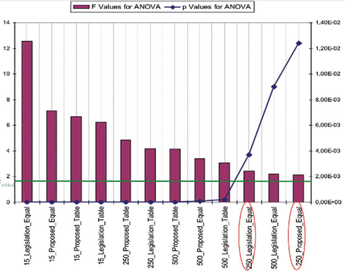
shows the results of ANOVA tests for 12 different scenarios. As expected, the differentiation in the suitability ranking was the highest level for 15-acre modes, which have the highest F values and the lowest P values. However, the differentiation in the suitability ranking was not at the lowest level for 500-acre modes. Furthermore, the “Proposed” modes showed lower differentiations in the suitability ranking as compared to the corresponding “Legislation” modes in some scenarios. Thus, the expectation that the differentiation level decreases as the counts of suitable areas decrease is not valid for all structures. According to this, it is hard to say that obtaining the most exact decision for site selection is ensured by working on large-scale area requirements.
Figure 5. The results of ANOVA tests for 12 different scenarios.
The results of the statistical analyses related to the experimental structures representing the main factors and all the interactions between them are given in . In order to clear the differentiations in the suitability ranking caused by the main factors, the impact orders and impact values (NIVs) presented in were simplified to display only the main factors. For this, the final impact levels (FILs) of the main factors were determined by adding own NIVs of the factors to the NIVs of the factors in the interactions with the assumption that the contribution of each factor in total differentiations is equal in an interaction. For example, the FIL of “H” structure is the sum of the NIV of the “H” structure, halves of the NIVs of the dual interactions of “H” with the structures “D,” “F,” and “G,” one-third of the NIVs of the triple interactions of “H” with the structures “B,” “C,” and “E,” and one-fourth of the NIV of the quadruple interaction of “H” with the structure “A” (see ). The same procedure was applied to the other main factors, and results are given in .
Table 5. Impact orders and NIVs (%) obtained for the main factors and the dual interactions between them
Table 6. Impact orders and FILs (%) obtained for the main factors
As shown in , the main factor with the lowest FIL was the criterion of “N” (proximity to customers) in seven out of 12 scenarios. The main factor with the highest FIL, on the other hand, varied from one scenario to another to different extents. The main factor with the highest FIL was the criterion of “L” (risk perception and approval of stakeholders) in five out of 12 scenarios and the criterion of “H” (visibility) in two out of 12 scenarios. In the same way, the main factor with the second highest FIL was the criterion of “L” (Risk perception and approval of stakeholders) in six out of 12 scenarios and the criterion of “H” (Visibility) in three out of 12 scenarios. Consequently, it is impossible to say that the differentiations of the suitability ranking caused by external criteria are negligible in the site selection procedure under all circumstances.
Conclusion
In site selection applications, it is generally expected that as the counts of suitable areas decrease, the probability of differentiation in the suitability ranking by any criteria decreases. For this reason, working on larsge-scale area requirements is usually preferred in site selection applications. Besides, the weights of criteria are determined by the subjective conditions of the residents and/or the decision makers, and the external criteria are generally not taken into account in the site selection procedure. What will happen if the decision makers are not right? In this study, it was indicated that some widespread expectations are not valid under all circumstances. In this case, it could be said that the incorrect final decisions made in the past could have caused some avoidable externalities.
The results obtained in this study suggest that the major factor causing differentiations in the suitability rankings may be the location of the suitable areas rather than their counts. On the other hand, since the external criteria are generally not considered in the current site selection procedures, the effects of the external costs on the total costs are neglected. The minimization of these external costs could be possible by involvement of the external criteria into the decision-making structure of the site selection procedure. The results of this study show that addition of external criteria such as “risk perception and approval of stakeholders” and “visibility” to the decision tree could cause significant differentiations in the final decision. Since visibility could be defined in physical terms, it could be integrated into the GIS-based structure easily. But the integration of risk perception could be possible only by the active participation of all the stakeholders in the site selection procedure.
Acknowledgment
The authors are grateful to all participants in the decision-making participation for their help, support, and advice. The authors also thank IZAYDAS and Kocaeli City Council for their valuable help.
Funding
This study was financed by IZAYDAS under a grant collaboration protocol (05.06.2011).
References
- Al-Yaqout , A.F. , Koushki , P.A. and Hamoda , M.F. 2002 . Public opinion and siting solid waste landfills in Kuwait . Resources Conserv. Recycling , 35 : 215 – 27 . doi: 10.1016/S0921-3449(01)00111-2
- Aragones-Beltran , P. , Pastor-Ferrando , J.P. , Garcia-Garcia , F. and Pascual-Agullo , A. 2010 . An analytic network process approach for siting a municipal solid waste plant in the metropolitan area of Valencia (Spain) . J. Environ. Manage , 91 ( 5 ) : 1071 – 86 . doi: 10.1016/j.jenvman.2009.12.007
- Chang , N.B. , Parvathinathan , G. and Breeden , J.B. 2008 . Combining GIS with fuzzy multicriteria decision-making for landfill siting in a fast-growing urban region . J. Environ. Manage , 87 : 139 – 53 . doi: 10.1016/j.jenvman.2007.01.011
- Cheng , S. , Chan , C.W. and Huang , G.H. 2002 . Using multiple criteria decision analysis for supporting decisions of solid waste management . J. Environ. Sci. Health A , 37 ( 6 ) : 975 – 90 . doi: 10.1081/ESE-120004517
- Chiueh , P. , Lo , S. and Chang , C. 2008 . A GIS-based system for allocating municipal solid waste incinerator compensatory fund . Waste Manage , 28 ( 12 ) : 2690 – 701 . doi: 10.1016/j.wasman.2008.01.006
- De Feo , G. and De Gisi , S. 2010 . Using an innovative criteria weighting tool for stakeholders involvement to rank MSW facility sites with the AHP . Waste Manage , 30 ( 11 ) : 2370 – 82 . doi: 10.1016/j.wasman.2010.04.010
- Defra (Department for Environment, Food and Rural Affairs) . 2003 . A study to estimate the disamenity costs of landfill in Great Britain: Final report , London, UK: DEFRA Publications .
- Dijkgraaf , E. and Vollebergh , H.R.J. 2004 . Burn or bury? A social cost comparison of final waste disposal methods . Ecol. Econ , 50 : 233 – 47 . doi: 10.1016/j.ecolecon.2004.03.029
- Eshet , T. , Ayalon , O. and Shechter , M. 2006 . Valuation of externalities of selected waste management alternatives: A comparative review and analysis . Resources Conserv. Recycling , 46 ( 4 ) : 335 – 64 . doi: 10.1016/j.resconrec.2005.08.004
- Eshet , T. , Baron , M.G. and Shechter , M. 2007a . “ Externalities from landfills and transfer stations; Applying and testing the benefit transfer method ” . In Landfill Research Focus , Edited by: Lehmann , E.C. New York, NY: Nova Science .
- Eshet , T. , Baron , M.G. , Shechter , M. and Ayalon , O. 2007b . Measuring externalities of waste transfer stations in israel using hedonic pricing . Waste Manage , 27 ( 5 ) : 614 – 25 . doi: 10.1016/j.wasman.2006.03.021
- Geneletti , D. 2010 . Combining stakeholder analysis and spatial multicriteria evaluation to select and rank inert landfill sites . Waste Manage , 30 ( 2 ) : 328 – 37 . doi: 10.1016/j.wasman.2009.09.039
- Gorsevski , P.V. , Donevska , K.R. , Mitrovski , C.D. and Frizado , J.P. 2012 . Integrating multi-criteria evaluation techniques with geographic information systems for landfill site selection: A case study using ordered weighted average . Waste Manage , 32 ( 2 ) : 287 – 96 . doi: 10.1016/j.wasman.2011.09.023
- Jamasb , T. and Nepal , R. 2010 . Issues and options in waste management: A social cost-benefit analysis of waste-to-energy in the UK . Resources Conserv. Recycling , 54 ( 12 ) : 1341 – 52 . doi: 10.1016/j.resconrec.2010.05.004
- Kontos , T.D. , Komilis , D.P. and Halvadakis , C.P. 2003 . Siting MSW landfills on Lesvos Island with a GIS-based methodology . Waste Manage. Res , 21 ( 3 ) : 262 – 77 . doi: 10.1177/0734242X0302100310
- Kontos , T.D. , Komilis , D.P. and Halvadakis , C.P. 2005 . Siting MSW landfills with a spatial multiple criteria analysis methodology . Waste Manage , 25 ( 8 ) : 818 – 32 . doi: 10.1016/j.wasman.2005.04.002
- Korucu , M.K. and Erdagi , B. 2012 . A criticism of applications with multi-criteria decision analysis that are used for the site selection for the disposal of municipal solid wastes . Waste Manage , 32 ( 12 ) : 2315 – 23 . doi: 10.1016/j.wasman.2012.07.003
- Korucu , M.K. , Arslan , O. and Karademir , A. 2013a . Siting a municipal solid waste disposal facility, Part one: An evaluation of different scenarios for a site selection procedure . J. Air Waste Manage. Assoc , 63 ( 8 ) : 879 – 885 . doi: 10.1080/10962247.2013.788459
- Korucu , M.K. , Cihan , A. , Alkan , A. , Ozbay , I. , Karademir , A. and Aladag , Z. 2013b . A divided process approach to mixed integer linear programming models for disposal method selection of municipal solid wastes , In review .
- Lober , D.J. 1995 . Resolving the siting impasse: Modeling social and environmental locational criteria with a geographic information system . J. Am. Plan. Assoc , 61 ( 4 ) : 482 – 95 . doi: 10.1080/01944369508975659
- Moeinaddini , M. , Khorasani , N. , Danehkar , A. and Darvishsefat , A.A. 2010 . Siting MSW landfill using weighted linear combination and analytical hierarchy process (AHP) methodology in GIS environment (Case study: Karaj) . Waste Manage , 30 ( 5 ) : 912 – 20 . doi: 10.1016/j.wasman.2010.01.015
- Na , M. , Kurihara , K. and Gion , N. 2007 . Optimal allocation of final waste disposal sites based on physical and social factors . J. Environ. Sci. Sustain. Society , 1 : 25 – 32 . doi: 10.3107/jesss.1.25
- Sharifi , M. , Hadidi , M. , Vessali , E. , Mosstafakhani , P. , Taheri , K. , Shahoie , S. and Khodamoradpour , M. 2009 . Integrating multi-criteria decision analysis for a GIS-based hazardous waste landfill sitting in Kurdistan Province, Western Iran . Waste Manage , 29 : 2740 – 58 . doi: 10.1016/j.wasman.2009.04.010
- Tavares , G. , Zsigraiova , Z. and Semiao , V. 2011 . Multi-criteria GIS-based siting of an incineration plant for municipal solid waste . Waste Manage , 31 : 1960 – 72 . doi: 10.1016/j.wasman.2011.04.013
- Wang , G. , Qin , L. , Li , G. and Chen , L. 2009 . Landfill site selection using spatial information technologies and AHP: A case study in Beijing, China . J. Environ. Manage , 90 ( 8 ) : 2414 – 21 . doi: 10.1016/j.jenvman.2008.12.008
- Vaillancourt , K. and Waaub , J. 2002 . Environmental site evaluation of waste management facilities embedded into EUGENE model: A multicriteria approach . Eur. J. Operational Res , 139 : 436 – 48 . doi: 10.1016/S0377-2217(01)00365-4
- Zelenovic Vasiljevic , T. , Srdjevic , Z. , Bajcetic , R. and Miloradov , M.V. 2012 . GIS and the analytic hierarchy process for regional landfill site selection in transitional countries: A case study from Serbia . Environ. Manage , 49 ( 2 ) : 445 – 58 . doi: 10.1007/s00267-011-9792-3