Abstract
A combination of multiplatform satellite observations and statistical data analysis are used to improve the correlation between estimates of PM2.5 (particulate mass with aerodynamic diameter less that 2.5 µm) retrieved from satellite observations and ground-level measured PM2.5. Accurate measurements of PM2.5 can be used to assess the impact of air pollution levels on human health and the environment and to validate air pollution models. The area under study is California's San Joaquin Valley (SJV) that has a history of poor particulate air quality. Attempts to use simple linear regressions to estimate PM2.5 from satellite-derived aerosol optical depth (AOD) have not yielded good results. The period of study for this project was from October 2004 to July 2008 for six sites in the SJV. A simple linear regression between surface-measured PM2.5 and satellite-observed AOD (from MODIS [Moderate Resolution Imaging Spectroradiometer]) yields a correlation coefficient of about 0.17 in this region. The correlation coefficient between the measured PM2.5 and that retrieved combining satellite observations in a generalized additive model (GAM) resulted in an improved correlation coefficient of 0.77. The model used combinations of MODIS AOD, OMI (Ozone Monitoring Instrument) AOD, NO2 concentration, and a seasonal variable as parameters. Particularly noteworthy is the fact that the PM2.5 retrieved using the GAM captures many of the PM2.5 exceedances that were not seen in the simple linear regression model.
Particulate Mass (PM) in the air is a concern because of its effect on climate and human health. PM concentrations retrieved from satellite observations of aerosol optical depth can provide broad regional coverage that is not attained by surface sites. The techniques developed in this paper have resulted in greatly improved correlations between PM retrieved from satellite observations and PM from surface measurements in areas where the correlation is typically low. These improved retrievals can be used to fill in the gaps between surface sites and validate air quality models that are used for air quality forecasts and epidemiological studies.
Supplemental Materials: Supplemental materials are available for this paper. Go to the publisher's online edition of the Journal of the Air & Waste Management Association for information on the effects of grid size and MODIS data quality flags on the GAM results. The coefficients for the GAMs used in this study are also listed.
Introduction
Particulate mass (PM) in the air is a concern in many regions of the United States and in the world because of its effect on climate and human health (CitationSolomon et al., 2007; CitationSamet et al., 2000; CitationPope et al., 2009; CitationKrewski et al., 2009). The Intergovernmental Panel on Climate Change has identified PM as one area in which more research is needed to reduce uncertainty in estimates of climate change (CitationSolomon et al., 2007). Also, epidemiology studies have shown that life expectancy is positively correlated with a decrease in the long-term exposure to fine-PM concentration (CitationPope et al., 2009). Elevated concentrations of PM2.5 (PM with aerodynamic diameter less that 2.5 μm) in California are associated with about 18,000 premature deaths each year. (Tran et al., 2009). Environmental agencies around the world monitor PM concentrations at surface sites. In the United States, there are approximately 1600 U.S. Environmental Protection Agency (EPA)-approved PM2.5 monitoring sites; however, these measurements are made at a single point. Point measurements are not necessarily representative of regional variability and satellite observations can help “fill in the gaps” between these measurement stations. In recent years, application of satellite observation to surface air quality has advanced considerably. Researchers have been working for years to use satellite observations to improve air quality forecasts and to provide information to assist regulators and policy makers (CitationWang and Christopher, 2003; CitationChu et al., 2003; CitationAl-Saadi et al., 2005).
Satellite observations provide a total-column aerosol optical depth (AOD) product, which is a measure of the extinction by aerosol total column and it can be related to PM (Koelemeijer et al., 2006). Correlations between AOD with PM using single-variate, least-squares linear regression (a simple linear regression) show considerable variation, with correlation coefficients (r 2) between 0 and 0.85 depending on the season and location, or region, of comparison. CitationHoff and Christopher (2009) review and discuss over 30 papers that have explored the relationship between surface PM and satellite AOD measurements. In some cases, notably in the western United States, there is little or no correlation (CitationAl-Saadi et al., 2005; CitationEngle-Cox et al., 2004; CitationKahn et al., 2005; CitationGupta et al., 2006). In general, satellite retrievals of AOD are most accurate over areas of dark vegetation that is more typical in the eastern United States (Levy et. al. 2010).
Many schemes have been applied to improving satellite-surface correlations. Satellite AOD measurements from MODIS (Moderate Resolution Imaging Spectroradiometer), MISR (Multiangle Imaging SpectroRadiometer), POLDER (POLarization and Directionality of Earth's Reflectance), and GOES (Geostationary Operational Environmental Satellite) have been the subject of these comparisons. CitationGupta et al. (2006) investigated linear correlations between MODIS AOD and PM2.5 at 25 urban areas. They found that correlations varied between 0.11 and 0.85. CitationKacenelenbogen et al. (2006) used simple linear regressions to compare POLDER AOD and surface PM2.5 measurements over France and obtained a correlation coefficient of 0.55 for the general area. CitationHoff and Christopher (2009) suggest that the poorer correlations in the western United States were due to a wider variation in aerosol types (more nitrate than sulfate and more biomass burning smoke than over the eastern part of the United States), higher surface reflectivity making passive satellite AOD retrieval difficult, and more elevated plumes in the AOD signatures. Elevated aerosol plumes, typically associated with long-range transport, are integrated into the column AOD retrieval but are not reflected in the surface PM measurements. Satellite AOD measurements have been combined with other parameters, such as the vertical structure of aerosol as calculated from a chemical transport model (Citationvan Donkelaar et al., 2010; Liu et al., 2009b), or estimates of boundary layer height and relative humidity from models (CitationLiu et al., 2005; Kacenelenbogan et al., 2006). Liu et al. (2009a) used fractional component AOD from MISR and aerosol vertical distributions from the GEOS-Chem transport model to constrain estimates of surface PM2.5. (GEOS—Chem is a global 3-D chemical transport model. See http://acmg.seas.harvard.edu/geos/index.html.) Liu et al. (2009a) used generalized linear regression models (GLMs) and model-generated meteorological fields to compare the ability of MISR and MODIS AOD to predict surface PM2.5 in the St. Louis region during 2003. The correlation coefficient between retrieved and measured PM using a GLM was r 2 = 0.62 and r 2 = 0.51 for MISR and MODIS, respectively.
A number of different statistical techniques have been used in an effort to improve the correlation between AOD and PM. CitationGupta and Christopher (2008) used multiple linear regression (MLR) and neural network techniques to include planetary boundary layer (PBL) height, location, temperature, and relative humidity (RH) in an analysis in the southeastern United States and achieved an improved r 2 of 0.7 using MLR and 0.83 using the neural network technique compared with r 2 of 0.41 for a simple linear regression model. CitationPelletier et al. (2007) applied generalized additive model (GAM) techniques to retrieve PM from the combination of AERONET (AErosol RObotic NETwork) AOD and National Center for Environmental Prediction (NCEP) meteorological data and compared with surface PM collected at two sites in northwestern Europe. Their model increase r 2 to 0.76 compared with an r 2 of 0.27 derived from a simple linear regression. CitationVidot et al. (2007) used the Pelletier et al. GAM method to relate surface PM with SeaWiFS (SeaWide Field-of-view Sensor), AOD, and NCEP meteorological parameters, achieving an r 2 of 0.61 compared with 0.48 for the linear case. CitationChudnovsky et al. (2012) have applied a mixed-effects model approach to AOD retrievals from the Geostationary Operational Environmental Satellite (GOES) to predict PM2.5 concentrations over New England. These studies motivated our use of GAM methods to improve estimates of PM only using satellite observations.
This paper demonstrates that combining observations from multiple satellite using advanced statistical techniques can dramatically improve the estimates of PM. These results are obtained using the remote satellite observations only, without surface measurements or input from meteorological models. Specifically, our technique uses GAMs to improve retrievals of PM from a combination of A-Train satellite observations. These improved retrievals can be used to fill in the gaps between surface measurements and validate air quality models that are used for air quality forecasts and epidemiological studies.
Methodology
Study area
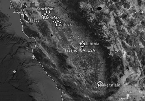
Our study concentrated on California's San Joaquin Valley (SJV) because of its importance as an agricultural area and its persistent problems with poor air quality. The SJV is home to over 3 million people and encompasses nearly 64,000 km2. Improved large-scale information on PM will be useful in validating the air quality models used in pollution and epidemiology studies in this area. The SJV is located southeast of San Francisco in the center of the state between the Coastal Mountain Range to the west and the Sierra Nevada Range to the east (see ). This topography leads to northwesterly winds during the spring, summer, and fall and a thick well-mixed boundary layer. During the winter, the winds abate and cold temperatures form an inversion layer keeping the boundary layer low and inhibiting surface mixing. The highest PM2.5 concentrations are typically found during the winter and fall. The winter and fall are also characterized by high concentrations of NH4NO3 (CitationBattye et al., 2003). Fresno, located in the center of the SJV, has a population of more than 500,000 and experiences frequent hospitalizations for asthma (Watson, 2000). From 1991 to 1996, PM2.5 annual averages ranged from 18 to 24 μg/m3, with the highest 24-hr averages ranging from 56 to 93 μg/m3. The 24-hr averages exceeded the National Ambient Air Quality Standards (NAAQS) for PM2.5, which are 15.0 μg/m3 for the annual average and 35 μg/m3 for the 24-hr average.
Figure 1. Map of the San Joaquin Air Pollution Control District in California showing the ground stations used in this study.
Elevated concentrations of PM2.5 can be associated with about 18,000 (ranging from 5600 to 32,000) premature deaths in California each year based on the 2004–2006 air quality data (Tran et al., 2009). Ground-based measurements are sparse in California and do not provide enough coverage for air quality monitoring. Further, there is little or no correlation between MODIS AOD and surface PM measurements in this region using single-variate, least-squares linear regressions (CitationEngle-Cox et al., 2004). Previous attempts to improve this correlation by taking into account surface reflectance included in the MODIS Deep Blue retrieval for bright surfaces (Hsu et. al., 2006) versus the standard MODIS dark-target retrieval models have met with little success (CitationBallard et al., 2008; CitationJustice et al., 2009).
Data used
Surface data.
The PM2.5 surface measurements for the years 2004–2008 came from sites maintained and operated by the California Air Resources Board (CARB) (, ). Air quality indicators such as chemical compounds and PM concentrations, ozone levels, and meteorological conditions are monitored at these sites (Bucsela et al., 2008). The sites used for this study are listed in (also see ).
Table 1. List of sites used in this study and their latitude and longitude
In this study, we use PM2.5 obtained using both the Federal Reference Method (FRM) gravimetric-filter-based samplers for daily PM and the beta attenuation monitor (BAM) for the hourly PM. The FRM samplers are the only samplers currently approved by the EPA to provide data for determining the attainment status for an area. The BAM continuous mass monitors are used to collect data for understanding the diurnal and episodic behavior of fine particles, transport assessment, and for use by health scientists investigating exposure patterns. BAM measurements are a confirmed U.S. Federal Equivalence Measurement relative to the 24-hr FRM standard (CitationZhu et al., 2007). The BAM determines the deposited mass by the attenuation of high-energy electrons through the sample filter. Accuracy is estimated to be ±8% of indication for hourly readings and ±2% for daily readings when compared with the FRM measurements (Ecotech, 2006).
Hourly PM2.5 and daily PM10 averages were obtained using the organization's online “Real-Time Query Tool”: http://www.arb.ca.gov/aqmis2/aqdselect.php All available relative humidity data, collected since 2002, were gathered using CARB's “Meteorological Data Query Tool”: http://www.arb.ca.gov/aqmis2/metselect.php
Satellite data.
The satellite data used in this study come from the Ozone Monitoring Instrument (OMI) onboard National Aeronautics and Space Administration's (NASA's) EOS-Aura (Earth Observing System-Aura) satellite and the MODIS onboard NASA's EOS-Aqua (CitationLevelt et al., 2006). Aqua and Aura were launched into a sun-synchronous orbit on May 4, 2002, and July 15, 2004, respectively. Aqua observes the SJV between 1:00 and 2:00 p.m., Pacific Standard Time. There is an approximate 8-min time lapse between the Aqua and Aura overpasses. MODIS AOD was used in this study because of its good spatial resolution, effective clouds mask algorithms, and its near-daily global coverage.
MODIS acquires daily global measurements with 36 spectral bands (from 0.41 to 14 μm) at three different spatial resolutions (250 m, 500 m, and 1 km). AOD is reported at 10 × 10-km2 resolution. MODIS high spatial and temporal resolutions are well suited for evaluating air quality on regional and global scales (CitationLevy et al., 2007a, Citation2007b). The MODIS data products used in this study were the Level II Aerosol Product, Corrected Optical Depth Land, Surface Reflectance Land, Quality Assurance Land, Deep Blue Aerosol Optical Depth Land, Deep Blue Surface Reflectance Land, and Optical Depth Land and Ocean. Both the standard MODIS dark-target and the Deep Blue algorithm require a surface reflectance value to retrieve AOD values. The standard MODIS AOD retrieval algorithm uses the dark-target approach over land. The land surface reflectance parameterization is based on an empirical relationship between surface reflectances measured in the visible channels and at 2.13 µm. The relationship is a function of geometry and a mid-infrared (IR) vegetation index measuring the greenness of the vegetation (Levy et al., 2007a). This algorithm is accurate for determining AOD above highly vegetated surfaces, but performs poorly over highly reflective surfaces such as cities and deserts. The SJV surface reflectance is a patchwork of bright and dark targets. We studied the effects of both parameters on estimating PM2.5 in this paper. The Deep Blue algorithm has proven to be successful at deriving AOD values over bright surfaces such as deserts (CitationHsu et al., 2006). Deep Blue uses a set of lookup tables based on a polarized radiative transfer model, allowing it to simulate the radiance for “a range of solar and viewing geometries at the top of the atmosphere” (Hsu et al., 2004). The MODIS dark-target AOD product lies within an expected error envelope of ±(0.05 + 15%) at 550 nm (CitationLevy et al., 2010).
The OMI is an imaging spectrometer that measures solar light backscattered by the Earth's atmosphere and surface (CitationBucsela et al., 2006). The instrument consists of two spectrometers, one measuring the ultraviolet (UV) spectral range from 270 to 365 nm in two subranges (UV1: 270–314 nm, resolution: 0.42 nm, sampling: 0.32 nm; UV2: 306–380 nm, resolution: 0.45 nm, sampling: 0.15 nm), the other measuring the UV-visible spectrum from 350 to 500 nm (resolution: 0.63 nm, sampling: 0.21 nm). OMI uses a charge-coupled diode (CCD) array with one dimension resolving the spectral features and the other dimension allowing a 114˚ field of view, providing a 2600-km viewing swath transverse to the orbit track. Its nadir spatial resolution ranges from 13 × 24 to 24 × 48 km2, depending on the instrument's operating mode and observing geometery. For this study, we used OMI aerosol optical depth, aerosol absorption optical depth (AAOD), and NO2 data product version 3. Good agreement is generally seen between the OMI NO2 measurements and ground-based measurements, with tropospheric columns underestimated by 15–30% (CitationCelarier et al., 2008).
For this study, time-coordinated data sets from October 2004 to July 2008 were used. Satellites provide AOD usually only once a day and correlations are typically better with hourly rather than daily PM2.5 surface measurements (CitationGupta and Christopher, 2008; CitationBallard et al., 2008; CitationJustice et al., 2009). CitationGupta and Christopher (2008) found that linear correlations increased from 0.52 to 0.62 when hourly data were used instead of daily. In this study, the surface PM2.5 measurement was taken at the nearest hour to the satellite overpass.
Relating PM and AOD
For cases where there are no significant aerosol plumes above the boundary layer, PM can be related to AOD (Koelemeijer et al., 2006) through the relationship
Ground-based measurements relate to the aerosol PM that is resident in the PBL. PBL height is a function of the local meteorology. For example in the SJV, winters are characterized by small PBL, resulting in high concentrations of PM near the surface. In the summer, the PBL is larger, resulting in decreased concentrations of PM near the surface due to dilution. The presence of f(RH) in Equationeq 1 shows that the surface RH also affects AOD because the uptake of water vapor onto particles increases their size and extinction efficiency. In this study, these meteorological effects are represented with a “seasonality” parameter, θ, that is modeled as a simple function of “day of year,” Admittedly, θ will not take into account episodes where large amounts of particles reside above the PBL, affecting AOD but not PM. Incorporating these occurrences in the present algorithm would likely improve results; however, information on the vertical distribution of particles in the atmosphere are not routinely available in the SJV from ground-based lidars, and data from the space-based Calipso lidar is too infrequent to be useful for this study. Finally, particle- and gas-phase constituents are interrelated through the processes of nucleation, condensation, and evaporation; therefore, a relationship between the satellite gas-phase product and the PM response can reasonably be expected. In this study, column concentrations of NO2 from the OMI satellite were found to be significant in the retrieval of PM.
Statistical methods
In a simple linear regression model, the relationship between a response y and parameters x 1, …, x p is given by
where the Bj are constants and ϵ is the residual error. In the simplest case, when PM is compared with AOD only, Equationeq 2 becomes
Linear regressions can be extended to include multiple parameters. In many cases, however, the relationships between the parameters and the response are not linear. Additive models are used to construct a regression function from smooth additive functions of the determining parameters, the fj (xj ). In an additive model, we replace the linear relationship ( Equationeq 1) between the parameters and response with a functional relationship so that an additive model takes the form
where the fj are simple, smooth arbitrary functions replacing the constant coefficients Bj . Replacing the Bj with fj is necessary to capture any nonlinear dependency of PM2.5 with other parameters. Some parameters may have a large effect on the response in only a particular part of their range. For example, a variable may be dominated by random error at very low values or have other undesirable effects at very high values, such as MODIS Deep Blue AOD as shown in For these reasons, it is appropriate to make the simple extension of linear to nonlinear regressions. GAMs are such an extension, retaining additive terms (CitationWood, 2006, 2007).
We explored many combinations of parameters looking for the best fit of “retrieved” to measured PM. Both the standard MODIS AOD data product and MODIS AOD derived using the Deep Blue algorithm (DB_AOD) were used because linear regressions of measured PM2.5 with DB_AOD gave marginally better correlations than using the standard MODIS product (CitationJustice et al., 2009). Preliminary studies showed a good correlation between PM2.5 and surface NOx (NOx = NO + NO2) measurements indicating that particulate pollution from transportation contributed to PM2.5 concentration. Because the goal of this study was to use only remote observations, OMI NO2 was used as a proxy for surface NOx and this proxy gave promising results. OMI aerosol optical depth (OMI_AOD) and aerosol absorption optical transmittance (OMI_AAOD) were included because they are derived from observations at shorter wavelengths and may be more sensitive to aerosols at higher altitudes. Finally, a seasonal parameter (Θ) was used to account for season effects on relative humidity and PBL height. With this full set of parameters, Equationeq 4 becomes
The requirement that all of these parameters were available for a given data set resulted in a small sample size. This is discussed in section “Effect of parameter selection on sample size.” Models for use in the GAM were constructed using subsets of these parameters to explore the tradeoff between improvements in retrieved PM and sample size. These models are shown in . EquationEquation 5 corresponds to model M. The notation, s(xj , k = n) designates the use of a spline function with n knots to model the effect of parameter xj . The spline coefficients for all these models are listed in Supplementary Materials.
Table 2. GAMs used in this study
The implementation used for the GAMs in this study was contained in the mgcv package of the R-project code (R Development Core Team, 2008; CitationWood, 2006, 2011). For all models, 80% of the data were randomly selected as a training data set for the GAM. The resultant model was tested on the remaining 20% of the data. This procedure was followed five times and the results averaged to ensure that the results were not affected by the random selection of the points. Two standard checks were employed to ensure that results were not influenced by some fortuitous aspects of the data set (see CitationWood, 2008; CitationFaraway, 2002). All forms given for the spline terms were checked using generalized cross-validation (the GCV of routine mgcv), which is a mathematically precise and informative method of selective data denial. Also, all terms, simple and spline-fit, were tested using visual analysis of partial residuals, which reveals any idiosyncrasies of the samples.
Results and Discussion
Linear regressions between parameters
When a particular response, in this case PM, is a function of multiple parameters, it is instructive to explore the relationship between different parameters. This information can guide the selection of parameters to include in a multiple regression and help explain the results of the analysis. Excellent correlations exist between AOD retrieved by the same method or instrument at different wavelengths. For example, the correlation between MODIS AOD at 0.47 and 0.55 μm using the standard retrieval (AOD_47 and AOD_55) is 0.97. The correlation for the Deep Blue retrieval (DB_AOD_47 and D_AOD_55) was also 0.97. The high correlation between AOD at different wavelengths may be due to the constraints that the MODIS retrieval puts on the wavelength dependence. MODIS AOD at 0.55 μm is derived from the measurements at 0.47 and 0.66 μm; however, the close correlation between the 0.47 and 0.55 μm values and the retrieval constraints indicate that no useful additional information is to be had by considering multiple wavelengths. This practice is typical of other satellite retrievals and indicates that no new information will be obtained from including both wavelengths from the same retrieval. Correlations for the linear regressions between the parameters of interest in this study are shown in . It is interesting that the AOD retrieved using different methods does not correlate very well: the correlation between AOD_47 and DB_AOD_47 was 0.35; the correlation between AOD_47 and OMI AOD was 0.15; and the correlation between DB_AOD_47 and OMI AOD was 0.007. The correlation between OMI AOD and AAOD was 0.55. These low correlations are surprising. They suggest that the different retrieval algorithms and inputs play an important role in determining AOD. They also suggest that different retrievals or observations may provide different information about the aerosol optical depth. This may be because the measurements are made at different wavelengths (OMI observations are made at shorter wavelengths than MODIS) or different assumptions are made for aerosol models or surface reflectance are used in the retrieval algorithm. The other surprising fact from the data in is the generally low level of correlation between the other parameters. Low correlations between PM and satellite observations in this region have been observed and commented on before. It is possible that observations from different satellites may represent different geographical areas or dependence on their respective grid and pixel coverage.
Table 3. Correlation coefficient (r 2) matrix for variables used in regressions
The use of a mixed-effects model is suggested because this data set contains several different kinds of AOD. A mixed-effects model approach is a generalization of the standard linear model that incorporates both fixed and random effects, and can account for repeated data sets. The authors explored a mixed-effects modeling approach, using the GAMM (generalized additive mixed model) function within the R code mgcv package (CitationWood, 2011); however, no particular advantage was found over the GAM. To understand why, one needs to look at the details of the “repeated measures” that were used in the data set. The standard MODIS AOD was obtained using a retrieval algorithm that got surface reflectance using the standard dark-target model. The MODIS Deep Blue AOD was obtained using an algorithm that got surface reflectance using the CitationHsu et al. (2006) method. The OMI AOD was obtained using radiances from a different instrument and a retrieval algorithm different from either algorithm used by MODIS. One can think of these different AODs as different interpretations of the same physical phenomenon. This is borne out by the poor correlation coefficients between the AODs shown in .
Correlations for Fresno site
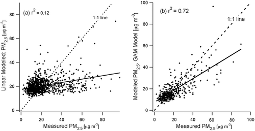
As an example of how the GAM can work for an individual site, we present here an analysis for the Fresno site. shows a scatter plot of PM2.5 derived from a linear regression of MODIS Deep Blue AOD (DB_AOD_47) and ground-based measured PM2.5. The ordinate is labeled as “modeled PM2.5” and the abscissa, “measured PM2.5.” The correlation coefficient, r 2, is 0.12. Note the lack of agreement especially for large values of PM2.5. These are the most important points to match because they are associated with the exceedance of EPA criterion pollutant standards, which is 35 μg/m3 for a 24-hr average PM2.5. shows a scatter plot of PM2.5 modeled using a GAM versus the measured PM2.5 for the same data. The correlation coefficient has improved to r 2 = 0.72 for PM2.5 measurements; therefore, for the Fresno site, the use of the GAM showed an improvement in the retrieved PM2.5 over the simple linear regression.
Figure 2. Scatter plots of retrieved PM2.5 versus measured PM2.5 for the Fresno site. (a) PM2.5 retrieved from a linear regression to MODIS AOD versus measured PM2.5 and (b) PM2.5 retrieved from GAM M–AA–DB versus measured PM2.5. The linear regression line is shown as a solid line and the 1:1 line is shown as a dashed line for reference.
Multisite retrieval
Data from all of our SJV sites are combined into one data set. A site-specific parameter was sued to differentiate between sites to account for topological and population differences, but it had a negligible contribution to the retrieval and it was not included in the parameter sets considered here.
An examination of the data shows that there are many more data points for low PM2.5 events than high PM2.5 events. This causes the GAM to put more weight on the lower PM events; however, it is the higher PM2.5 events (the exceedances) that are of greater importance to the community, regulators, and epidemiologists. For the purposes of this study, we chose to weight the response using a weighting factor related to the value of PM2.5 itself. In the general retrieval process, PM2.5 is not known a priori so weighting was accomplished using an iterative process. First the GAMs were run without weighting. These results can be seen in in the row titled “r 2 for GAM” and range between 0.55 and 0.59 for the various models used. This is a great improvement over the simple linear regression shown in the row titled “r 2 for linear,” which range from 0.08 to 0.18. The resultant retrieved PM values were used to establish a weighting and the GAMs were run again. These data are shown in in the row titled “r 2 for weighted GAM” and show a marked improvement over the unweighted GAM. Values of r 2 for the 6 models varied from 0.74 to 0.77. The model that includes all of the parameters, M_AA_DB, gave the best performance.
Table 4. Correlation coefficients, number of valid points, and parameter significance using 3 × 3 MODIS grids for several GAMs compared with a linear regression and with the GAMs weighted as described in the “Multisite retrieval section.
Taylor diagrams (Taylor et al., 2001; Taylor, 2008) are used to visually compare the performance of statistical models, taking into account the standard deviation and correlation coeffiecent. A Taylor diagram is a polar plot with the standard deviation as the radial axis and the correlation coefficient as the angular axis. is an example of a Taylor diagram for the six models described in . The point of the abscissa is the standard deviation of the reference measurement, in this case the measured PM2.5. The curved dashed lines represent the distance from the reference point and indicate the root mean square difference between the model and reference measurement. shows that all six GAMs used in this study lie very close to each other, demonstrating that there is not much difference in the performance of these models. We chose to concentrate on model M– AA, – DB because it includes the most sample points.
Figure 3. Taylor diagram comparing the performance of the six GAMs of .
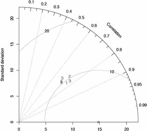
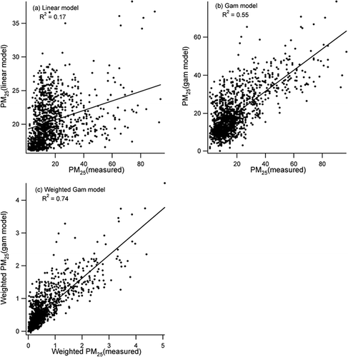
Figure 4 shows scatter plots of modeled/measured PM2.5 concentrations for three different cases. is a scatter plot of PM2.5 retrieved from a linear regression to MODIS AOD versus measured PM2.5. is a scatter plot of PM2.5 retrieved from GAM M–AA,–DB versus measured PM2.5, and represents the same data plotted in weighted space. When using a weighting function, it is appropriate to look at the correlation as a function of the weighted variables. A standard correlation between two variables, x and y, is
Figure 4. Scatter plots comparing retrieved/measured PM2.5 for data points valid with the M–AA–DB model. (a) PM2.5 retrieved from a linear regression to MODIS AOD versus measured PM2.5; (b) PM2.5 retrieved from GAM M–AA–DB versus measured PM2.5; and (c) PM2.5 retrieved from the weighted GAM, M–AA–DB, versus measured PM2.5 weighted space. The linear regression line for the retrieved/measured PM2.5 is shown as a solid line.
where μ is the mean value and σ is the standard deviation of the parameter x or y. The weighting function, wn , used was based on the retrieve values
to insure that the weighting function was normalized. The weighted correlation becomes
Figure 4c shows the scatter plot for the weighted observed and retrieved PM2.5. It is clear that the weighted results matched a larger number of the higher values of PM2.5.
Parameter sensitivities
From it is clear that OMI NO2 was a significant contributor to predicting PM2.5. This is probably because OMI NO2 is a measure of how much the SJV is affected by NOx-generating polluters, in this case, vehicle traffic. NO2 is formed in the environment from primary emissions of oxides of nitrogen. Although there are natural sources of NOx (e.g., forest fires), the combustion of (fossil) fuels has been, and remains, the major contributor in the SJV. Traffic pollution and power plants are two of the biggest sources of NO2 pollution in the United States. Sulfate aerosol make up only about 5% of the total aerosol in the Fresno area, whereas nitrate makes up about 25% and black carbon (BC) and organic carbon (OC) make up about 18% and 21%, respectively (CitationMcMurry et al., 2004). Nitrate is often a major component, and substantial conversion from NO2 to nitrate may occur within 30–60 km, or one to two OMI footprint regions (CitationValin et al., 2011). Locally measured PM2.5 and local nitrogen oxide measurements correlate geographically, responding to strong local urban (traffic) sources. In turn, local nitrogen oxide measurements correlate with satellite-derived NO2 column concentrations.
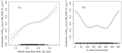
Figure 5 shows the relationships between the response (PM2.5) and the parameters (e.g., AOD, NO2). shows the contribution that the MODIS Deep Blue AOD (DB_AOD_47) parameter has on the response, PM2.5. This contribution is the coefficient, fj in Equationeq 4, which corresponds to the parameter MODIS Deep Blue AOD. The contribution is monotonically increasing as expected. The comb on the x-axis shows where the value of DB_AOD_47 data points lie. There is a high concentration of points in the middle range from about 1.75 to 2.75. At the very low and high values of AOD, the contribution to PM is no longer linear. In the low-AOD range, the contribution to PM2.5 is smaller, probably reflecting the sensitivity of the instrument. In the high-AOD range, PM2.5 is more sensitive to DB_AOD_47.
Figure 5. Plot of smoothed splines used to account for the contribution of PM2.5 due to (a) MODIS Deep Blue AOD (DB_AOD_47) and (b) seasonality parameter, θ. These sensitivity plots give a partial contribution to the PM2.5 in μg m−3, which adds to other contributions.
Our premise was to use only remote observations to retrieve surface PM2.5 values and no reliable observations of PBL or RH could be obtained from remote sources. Attempts to use PBL and RH from assimilations models were fruitless because these proved to be inaccurate unless meteorology was included in the assimilation. The usefulness of our retrievals for validating model predictions of PM2.5 would be compromised if the same meteorological model was used in estimating PBL and RH. Thus, introducing a seasonality parameter was the logical way to account for the strong seasonal variation in PM2.5 in the SJV and the day-of-year parameter was the best choice for this study. It is not uncommon to take seasonal variation into account in retrieving PM2.5 from remote measurements. For example, Liu et al. (2009a) discriminated between spring and nonspring seasons in their work using GAMs and model-generated meteorological fields.
One limitation with using day-of-year parameter is that the effects of long- and short-range transport at high altitude are not taken into account. Investigating the relationship between sunphotometer-derived AOD to PM at Ispra, Italy, CitationBarnaba et al. (2010) found that maximum AOD occurred in spring/summer and maximum PM values occurring in winter. They were able to use coincident lidar measurements to demonstrate that the variation in aerosol vertical distribution was important in this discrepancy. CitationJustice et al. (2009) also found that surface measurements of PM2.5 in SJV were greatest in the winter, whereas MODIS AOD values were lowest in the winter. However, because there are no lidar sites in the SJV, we were unable to explore the affect of the vertical resolution of aerosol in this study. The lack of information on the vertical structure of aerosol in the SJV remains a serious limitation to the study of aerosol in the SJV and for improved retrievals of PM2.5 from satellite observations.
Figure 5b shows that the seasonal parameter (day-of-year) has a strong effect on retrieved PM2.5 and shows that it is statistically significant. shows that the effect of the seasonal parameter on PM2.5 is stronger during the winter season (days 0–50 and 300–356) and weaker during the rest of the year (days 100–250). This result is not surprising given the seasonal dependence of PM2.5 in the SJV. Most studies take the seasonal dependence into account to some degree to have success in retrieving PM (CitationGupta and Christopher, 2008; Liu et al., 2009a).
Effect of parameters selection on sample size
The number of “valid” data points for a particular model is dependent upon the parameters in the model. In order for a point to be “valid” for a particular model, all parameters in the model must have a valid value. The number of valid data points that can be used with a particular model is dependent upon the number and kind of parameters in the model. For example, in model M (see ), where all six parameters are used, the number of valid points is 549, whereas the number of valid points increases to 817 in model M_St when only the MODIS standard AOD is dropped. compares the results of the six models listed in for the same points as in the most restrictive model, M, with the largest number of parameters. Predictably, the r 2 for the various models are the same or higher than for cases where all available points are used.
Table 5. Effect of adding observation type on the number of data points with valid data
The effect of the different GAMs on the number of valid points can also be seen in . The GAM with the most parameters gives the best results; however, the number of points is small. By not including two of the most restrictive parameters, OMI_AAOD and DB_AOD, the number of points using GAM M–AA–DB has increased nearly 4 times to 2070 and the r 2 has decreased to 0.74 for the case of the 3 × 3 MODIS grid. As discussed, adding more parameters significantly reduced the sample size. In this case the sample size was reduced from 2070, when only four parameters were considered, to 549 when all six parameters were considered. Thus, the GAM M–AA–DB gave almost the same performance as the six-parameter model, M (see ), and considered nearly four times the valid data points. The significance of the parameters is shown in by significance codes. It can be seen in that when the parameters used in a GAM are changed, the functions (e.g., fj in Equationeq 4) and significance of the new set of parameters also change. This would not occur if all the predicting variables were orthogonal to each other, but they rarely are (CitationDraper and Smith, 1998; CitationWood, 2006).
Retrieved and observed PM trends
To further illustrate the utility of the multisatellite GAM retrieval, the measured PM2.5 is compared with the retrieved values and plotted versus the day of the study period in shows the measured PM2.5 as black dots and the retrieved PM2.5 as gray dots. The retrieved PM2.5 were obtained using the results of a linear regression of MODIS AOD to PM2.5. The black and gray lines are loess fits to the measured and retrieved points, respectively. A straight dot-dashed line marks the EPA 24-hr criterion for reference. It is seen that the retrieved PM2.5 using the linear regression model does not capture the trend of the measured values and never does reach the USEPA criterion.
Figure 6. Trends of retrieved and measured PM2.5 in SJV. The gray and black points are the retrieved and measured PM2.5, respectively. The gray and black lines are loess fits to the retrieved and measured PM2.5, respectively. (a) Linear model; (b) GAM. The EPA 24-hr criterion is shown as a dot-dashed line.
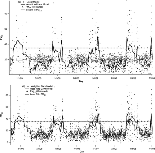
In , the black dots are once again the measured PM2.5 and the gray dots represent the retrieved values of PM2.5 from the GAM M–AA–DB. The black and gray lines are loess fits to the measured and retrieved points, respectively, and the dot-dashed line marks the EPA 24-hr criterion. It is seen that the retrieved PM2.5 from the GAM more closely matches the measured values. Seasonal trends can be seen in the retrieved GAM values that match those of the measured values. In particular, many exceedances are captured. Of the 2070 data points in the set, the surface measurements recorded 149 exceedances. The linear fit recorded 6 and the GAM fit recorded 167. The GAM correctly identified 69% of the exceedances and 14% of the retrieved exceedances were false positives. Although this is a big improvement, it underscores the fact that there is a long way to go before surface measurements will be replaced by satellite retrievals for regulatory purposes; however, we contend that the real near-term utility of satellite-derived PM will be in filling in the gaps of surface measurements to improved validation of air quality models and for epidemiology studies.
Conclusion
This paper shows that using GAMs with multiplatform satellite observations can improve the correlation between observed and retrieved PM2.5 in California's SJV. PM2.5 retrieved using a simple linear regression with MODIS AOD yields correlation coefficients between 0.08 and 0.18 for this region. The GAM implementation used was from the mgcv routine of R, a commonly available, free statistical program. The parameters used are MODIS AOD (standard dark-target algorithm, MODIS Deep Blue AOD, OMI AOD, OMI AAOD, OMI NO2 concentration, and a seasonal parameter. Using the GAM techniques and combinations of these parameters, the correlation coefficients between retrieved and measured PM2.5 ranged between 0.74 and 0.77. The best retrieval used all of these parameters, r 2 = 0.77; however, the number of data points was low, 549. The model that included MODIS standard dark-target AOD, OMI AOD, OMI NO2, and a seasonal parameter gave a correlation coefficient of 0.74 but increased the number of points to 2070. Particularly noteworthy is the fact that the PM2.5 retrieved using the GAM captures many of the PM2.5 exceedances that were not captured with the simple linear regression. It was also found that the MODIS grid of 3 × 3 yielded better results than either a 1 × 1 or a 5 × 5 grid. This grid size compared well with the OMI pixel size.
Further improvements to any new technique are always needed. The GAMs and input data can be refined by using other combinations of parameters and including more measurement sites, especially rural sites. Certainly, the inclusion of other available data, especially information on the vertical distribution of particles, when available, may further improve these results. The question of the general applicability of this technique also needs to be addressed in the future. We intend to apply this technique to other areas globally that have similar topography to the SJV and that have demonstrated poor correlations between AOD and PM2.5. We expect that the combinations of parameters used in the SJV will be useful in these areas. For example, the meteorology, surface conditions, and pollution sources particular to the SJV can also be found in other areas of the planet, such as the Po Valley in Italy, China's Red Basin, and the Indo-Gangetic Plain. In other areas, it is likely that the parameters will have to be changed to improve correlation of retrieved and measured PM2.5; however, the methodology presented here should be applicable. We feel that the techniques demonstrated in this study can be used to greatly enhance the utility of satellite-retrieved PM2.5 for air quality purposes. The GAM allows one to see the relationships between the parameters and the response that may lead to improved understanding of the physical phenomena involved.
Improved retrieved PM2.5 from satellite data will have profound benefits. They will be valuable in validating emission inventories used in global climate models and for validation of air quality models. They will be especially useful in sparsely populated regions where no data are available and areas where residents are exposed to significant PM2.5 concentrations but where measurements are not available. Such data can be used to track pollution transport, suggest the placement of future surface monitoring stations, and support epidemiological studies that seek to identify the sources of the most toxic air pollutants and the susceptible populations. These techniques will prove useful in improving satellite observations of particulate as well as gas-phase air quality, not only in the western United States, but globally.
Supplementary Material
Download PDF (282.3 KB)Acknowledgment
MODIS data were obtained from the Goddard Earth Sciences (GES) Data and Information Services Center (DISC) and OMI data were obtained from the OMI International Science Team for the OMI satellite data. The authors wish to acknowledge the MODIS and OMI teams for the use of their data products. Drs. Lorraine Remer and Richard Kleidman gave the authors valuable insight on the use of MODIS aerosol data products and on the techniques used in this study. Dr. Omar Torres gave the authors valuable insight on the use of the OMI aerosol data products. The comments of Ms. Meytar Sorek-Hamer and Dr. Raymond Hoff were very valuable.
The authors acknowledge the personnel of CARB for the effort required to collect the surface data used in this study. Much of the surface measurements used in this study were compiled by two teams of students working at Ames under the NASA DEVELOP program under the leadership of Dr. J. Skiles and Ms. C. Schmidt during the summers of 2009 and 2010. Dr. A. Strawa was the mentor for these groups.
Related Research Data
References
- Abdou , W.A. , Diner , D.J. , Martonchik , J.V. , Bruegge , C.J. , Kahn , R.A. , Gaitley , B.J. , Crean , K.A. , Remer , L.A. and Holben , B.N. 2005 . Comparison of coincident Multiangle Imaging Spectroradiometer and Moderate Resolution Imaging Spectroradiometer aerosol optical depths over land and ocean scenes containing Aerosol Robotic Network sites . J. Geophys. Res. , 110 ( D10 ) : 11967 – 11976 . doi: 10.1029/2004JD004693
- Al-Saadi , J. , Szykman , J. , Pierce , R.B. , Kittaka , C. , Neil , D. , Chu , D.A. , Remer , L. , Gumley , L. , Prins , E. , Weinstock , L. , MacDonald , C. , Wayland , R. , Dimmick , F. and Fishman , J. 2005 . Improving national air quality forecasts with satellite aerosol observations . Bull. Am. Meterol. Soc. , September : 1249 – 1261 . doi: 10.1175/BAMS-86-9-1249
- Anderson , T. L. , Robert , J. , Charlson , R. J. , David , M. , Winker , D. M. , John , A. , Ogren , J. A. and Holmén , K. 2003 . Mesoscale variations of tropospheric aerosols . J. Atmos. Sci. , 60 : 119 – 136 . doi: 10.1175/1520-0469(2003)060<0119:MVOTA>2.0.CO;2
- Ballard , M. , Newcomer , M. , Rudy , J. , Lake , S. , Sambasivam , S. , Strawa , A.W. , Schmidt , C. and Skiles , J.W. 2008 . Understanding the correlation of San Joaquin air quality monitoring with aerosol optical thickness satellite measurements , Portland , , OR, October : Paper presented at the American Society of Photogrammetry and Remote Sensing Annual Conference .
- Barnaba , F. , Putaud , J.P. , Gruening , C. , dell'Acqua , A. and Dos Santos , S. 2010 . Annual cycle in co-located in situ, total-column, and height-resolved aerosol observations in the Po Valley (Italy): Implications for ground-level particulate matter mass concentration estimation from remote sensing . J. Geophys. Res. , 115 : D19209 doi: 10.1029/2009JD013002
- Battye , W. , Aneja , V.P. and Roelle , P.A. 2003 . Evaluation and improvement of ammonia emissions inventories . Atmos. Environ. , 37 : 3873 – 3883 . doi: 10.1016/S1352-2310(03)00343-1
- Bucsela , E.J. , Celarier , E.A. , Weing , M.O. , Gleason , J.F. , Veefkind , J.P. , Boersma , J.P. and Brinksma , E.J. 2006 . Algorithm for NO2 vertical column retrieval from the Ozone Monitoring Instrument . IEEE Trans. Geosci. Remote Sens. , 44 : 1245 – 1258 . doi: 10.1109/TGRS.2005.863715
- California Air Resources Board . 2008 . Emission Data by Region (Statewide) , Sacramento : California Air Resources Board .
- Celarier , E.A. 2008 . Validation of Ozone Monitoring Instrument nitrogen dioxide columns . J. Geophys. Res. , 113 : D15S15 doi: 10.1029/2007JD008908
- Chow , J.C. , Watson , J.G. , Lowenthal , D.H. , Chen , L.-W. , Tropp , R.J. , Park , K. and Magliano , K.A. 2006 . PM2.5 and PM10 mass measurements in California's San Joaquin Valley . Aerosol Sci. Technol. , 40 : 796 – 810 . doi: 10.1080/02786820600623711
- Chu , D.A. , Kaufman , Y.J. , Zibordi , G. , Chern , J.D. , Mao , J. , Li , C.C. and Holben , B.N. 2003 . Global monitoring of air pollution over land fom the Earth Observing System-Terra Moderate Resolution Imaging Spectrometer (MODIS) . J. Geophys. Res. Atmos. , 108 : 4661 doi: 10.1029/2002jd003179
- Chudnovsky . 2012 . J. Air Waste Manage. Assoc Prediction of daily fine particulate matter concentrations using aerosol optical depth retrievals from the Geostationary Operational Environmental Satellite (GOES), 62:1022–1031. doi: 10.1080/10962247.2012.695321
- Draper , N.R. and Smith , H. 1998 . Applied Regression Analysis, Vol. 1. Volume 326 of Wiley Series in Probability and Statistics , 3rd , Hoboken , NJ : Wiley Interscience .
- Engle-Cox , J.A. , Holloman , C.H. , Coutant , B.W. and Hoff , R.M. 2004 . Qualitative and quantitative evaluation of MODIS satellite sensor data for regional and urban scale air quality . Atmos. Environ. , 38 : 2495 – 2509 . doi: 10.1016/j.atmosenv.2004.01.039
- Faraway, J. 2002. Practical regression and ANOVA in R http://www.maths.bath.ac.uk/~jjf23/book/pra.pdf (http://www.maths.bath.ac.uk/~jjf23/book/pra.pdf)
- Goody , R.M. and Yung , Y.L. 1989 . Atmospheric Radiation, Theoretical Basis , 2nd , New York : Oxford University Press .
- Gupta , P. and Christopher , S.A. 2008 . Seven year particulate matter air quality assessment from surface and satellite measurements . Atmos. Chem. Phys. , 8 : 3311 – 3324 . doi: 10.5194/acp-8-3311-2008
- Gupta , P. , Christopher , S.A. , Wang , J. , Gerhrig , R. , Lee , Y. and Kumar , N. 2006 . Satellite remote sensing of particulate matter and air quality assessment over global cities . Atmos. Environ. , 40 : 5880 – 5892 . doi: 10.1016/j.atmosenv.2006.03.016
- Hidy , G.M. , Brook , J.R. , Chow , J.C. , Green , M. , Husar , R.B , Lee , C , Scheffe, A. Swanson , R.D. and Watson , J.G. 2009 . Remote sensing of particulate pollution from space: Have we reached the promised land? . J. Air Waste Manage. Assoc. , 59 : 1130 – 1139 . doi: 10.3155/1047-3289.59.10.1130
- Hoff , R.M. and Christopher , S.A. 2009 . Remote sensing of particulate pollution from space: Have we reached the promised land? . J. Air Waste Manage. Assoc. , 59 : 645 – 675 . doi: 10.3155/1047-3289.59.6.645
- Hsu , N.C. , Tsay , S.-C. and King , M.D. 2004 . Aerosol properties over bright-reflecting source regions . IEEE Trans. Geosci. Remote Sens. , 42 : 3 doi: 10.1109/TGRS.2004.824067
- Hsu , N.C. , Tsay , S.-C. , King , M.D. and Herman , J.R. 2006 . Deep Blue retrievals of Asian aerosol properties during ACE-Asia . IEEE Trans. Geosci. Remote Sens. , 44 : 11 doi: 10.1109/TGRS.2006.879540
- Hyslop , N.P and Wittig , A.E. 2000 . Standard operating procedure for routine operations of the Met One Model 1020 Beta Attenuation Monitor for particulate matter mass in CRPAQS, CARB, Report, STI-999214 ,
- Ichoku , C. , Chu , D.A. , Mattoo , S. , Kaufman , Y.J. , Remer , L.A. , Tanré , D. , Slustsker , I. and Holben , B.N. 2002 . A spactio-temporal approach for global validation and analysis of MODIS aerosol products . Geophys. Res. Lett. , 29 : 12 doi: 10.1029/2001GL013206
- Justice , E. , Huston , L. , Krauth , D. , Mack , J. , Oza , S. , Strawa , A.W. , Skiles , J.W. , Legg , M. and Schmidt , C. 2009 . Investigating correlations between satellite-derived aerosol optical depth and ground PM2.5 measurements in California's San Joaquin Valley with MODIS Deep Blue , Baltimore , , Maryland, October 2009 : Presented at the American Society of Photogrammetry and Remote Sensing Annual Conference .
- Kacenelenbogen , M. , Leon , J.-F. , Chiapello , I. and Tanre , D. 2006 . Characterization of aerosol pollution events in France using ground-based and POLDER-2 satellite data . Atmos. Chem. Phys. , 6 : 4851 – 4866 . doi: 10.5194/acpd-6-6299-2006
- Kahn , R.A. , Gaitley , B.J. , Martonchik , J.V. , Diner , D.J. and Crean , K.A. 2005 . Multiangle Imaging Spectroradiometer (MISR) global aerosol optical depth validation based on 2 years of coincident aerosol Robotic Network (AERONET) observations . J. Geophys Res. , 110 : D10S04 doi: 10.1029/2004JD004706
- Krewski , D. , Jerrett , M. , Burnett , R.T. , Ma , R. , Hughes , E. , Shi , Y. , Turner , M.C. , Pope , C.A. , Thurston , G. , Calle , E.E. and Thun , M.J. 2009 . “ Extended Follow-up and Spatial Analysis of the American Cancer Society Study Linking Particulate Air Pollution and Mortality ” . In Health Effects Institute Research Report 140 , Boston : Health Effects Institute Research .
- Lary , D.J. , Remer , L.A. , MacNeill , D. , Roscoe , B. and Paradise , S. 2009 . Machine learning and bias correction for M ODIS aerosol optical depth . IEEE Geosci. Remote Sens. Lett. , 6 : 4 doi: 10.1109/LGRS.2009.2023605
- Levelt , P.F. , Hilsenrath , E. , Leppelmeier , G.W. , van den Oord , G.B.J. , Bhartia , P.K. , Tamminen , J. , de Hann , J.F. and Veefkind , J.P. 2006 . Science objectives of the Ozone Monitoring Instrument . IEEE Trans. Geosci. Remote Sens. , 44 : 1199 – 1208 . doi: 10.1109/TGRS.2006.872336
- Levy , R.C. , Remer , L. and Dubovik , O. 2007a . Global aerosol optical properties and application to MODIS aerosol retrieval over land . J. Geophys. Res. , 112 : D13210 doi: 10.1029/2006JD007815
- Levy , R.C. , Remer , L.A. , Kleidman , R.G. , Mattoo , S. , Ichoku , C. , Kahn , R. and Eck , T.F. 2010 . Global evaluation of the Collection 5 MODIS dark-target aerosol products over land . Atmos. Chem. Phys. , 10 : 10399 – 10420 . doi: 10.5194/acp-10-10399-2010
- Levy , R.C. , Remer , L. , Mattoo , S. , Vermote , E. and Kaufman , Y.J. 2007b . Second-generation algorithm for retrieving aerosol properties over land from MODIS spectral reflectance . J. Geophys. Res. , 112 : D13211 doi: 10.1029/2006JD007811
- Liu , Y. , Franklin , M. , Kahn , R. and Koutrakis , P. 2007 . Using aerosol optical thickness to predict ground-level PM¬2.5 concentrations in the St. Louis area: A comparison between MISR and MODIS . Remote Sens. Environ. , 107 : 33 – 44 . doi: 10.1016/j.rse.2006.05.022
- Lui , Y. , Koutrakis , P. and Kahn , R. 2009a . Estimating fine articulate matter component concentrations and size distributions using satellite-retrieved fractional aerosol optical depth: Part 1—Method development . J. Air Waste Manage. Assoc. , 57 : 1351 – 1359 . doi: 10.3155/1047-3289.57.11.1351
- Lui , Y. , Koutrakis , P. , Kahn , R. , Turquety , R. and Yantosca , R.M. 2009b . Estimating fine particulate matter component concentrations and size distributions using satellite-retrieved fractional aerosol optical depth: Part 2 . J. Air Waste Manage. Assoc. , 57 : 1360 – 1369 . doi: 10.3155/1047-3289.57.11.1360
- Liu , Y. , Sarnat , J.A. , Kilaru , V. , Jacob , D.J. and Koutrakis , P. 2005 . Estimating ground-level PM2.5 in the eastern United Sates using satellite remote sensing . Environ. Sci. Technol. , 39 : 3269 – 3278 . doi: 10.1021/es049352m
- McMurry , P. , Shepherd , M. and Vickery , J. 2004 . Particulate Matter Assessment for Policy Makers: A NARSTO Assessment , Cambridge , U.K : Cambridge University Press .
- Nychka , D. 1988 . Bayesian confidence intervals for smoothing splines . J. Am. Stat. Assoc. , 83 : 1134 – 1143 . doi: 10.1080/01621459.1988.10478711
- Pelletier , B. , Santer , R. and Vidot , J. 2007 . Retrieving of particulate matter from optical measurements: A semiparametric approach . J. Geophys. Res. , 112 : D06208 doi: 10.1029/2005JD006737
- Pope , C.A. , Ezzati , M. and Dockery , D.W. 2009 . Fine-particulate air pollution and life expectany inthe United States . N. Engl. J. Med. , 360 : 376 – 386 . doi: 10.1056/NEJMsa0805646
- Remer , L.A. , Kaufman , Y.J. , Tanré , D. , Mattoo , S. , Chu , D.A. , Vanderlei Martins , J. , Ichoku , C. , Levy , R.C. , Kleidman , R. , Eck , T.F. , Vermote , E. and Holben , B.N. 2005 . The MODIS aerosol algorithm, products and validation . J. Atmos. Sci. , 62 : 947 – 973 . doi: 10.1175/JAS3385.1
- Samet , J.M. , Dominici , F. , Curriero , F.C. , Coursac , I. and Zeger , S.L. 2000 . Fine particulate air pollustio and mortality in 20 U.S. cities, 1987–1994 . N. Engl. J. Med. , 343 : 24 doi: 10.1056/NEJM200012143432401
- Schervish , M. 1996 . P values: What they are and what they are not . J. Am. Stat. , 50 : 203 – 206 . doi: 10.2307/2684655
- Van Donkelaar , A. , Martin , R. , Brauer , M. , Kahn , R. , Levy , R. , Verduzco , C. and Villeneuve , P.J. 2010 . Global estimates of ambient fine particulate matter concentrations form satellite-based optical depth: Development and application . Environ. Health Perpect. , 118 : 847 – 855 . doi: 10.1289/ehp.0901623
- Solomon , S. , Qin , D. , Manning , M. , Alley , R.B. , Berntsen , T. , Bindoff , N.L. , Chen , Z. , Chidthaisong , A. , Gregory , J.M. , Hegerl , G.C. , Heimann , M. , Hewitson , B. , Hoskins , B.J. , Joos , F. , Jouzel , J. , Kattsov , V. , Lohmann , U. , Matsuno , T. , Molina , M. , Nicholls , N. , Overpeck , J. , Raga , G. , Ramaswamy , V. , Ren , J. , Rusticucci , M. , Somerville , R. , Stocker , T.F. , Whetton , P. , Wood , R.A. and Wratt , D. 2007 . “ Technical summary ” . In Climate Change 2007: The Physical Science Basis. Contribution of Working Group I to the Fourth Assessment Report of the Intergovernmental Panel on Climate Change , Edited by: Solomon , S. , Qin , D. , Manning , M. , Chen , Z. , Marquis , M. , Averyt , K.B. , Tignor , M. and Miller , H.L. Cambridge, UK: : Cambridge University Press .
- Valin , L.C. , Russell , A.R. , Hudman , R.C. and Cohen , R.C. 2011 . Effects of model resolution on the interpretation of satellite NO2 observations . Atmos. Chem. Phys. , 11 : 11647 – 11655 . doi: 10.5194/acp-11-11647-2011
- Vidot , J. , Santer , R. and Ramon , D. 2007 . Atmsopheric particulate matter (PM) estimation from SeaWiFS imagery . Remote Sens. Environ. , 111 : 1 – 10 . doi: 10.1016/j.rse.2007.03.009
- Wang , J. and Christopher , S.A. 2003 . Intercomparison between satellite-derived aerosol optical thickness and PM2.5 mass: Implications for air quality studies . Geophys. Res. Lett. , 30 : 2095 doi: 10.1029/2003g1018174
- Watson , J.G. , Chow , J.C. , Bowen , J.L. , Lowenthal , D.H. , Hering , S. , Ouchida , P. and Oslund , W. 2000 . Air quality measurements from the Fresno Super Site . J. Air Waste Manage. Assoc. , 50 : 1321 – 1334 . doi: 10.1080/10473289.2000.10464184
- Wood , S.N. 2006 . Generalized Additive Model: An Introduction with R , Boca Raton , FL : Chapman & Hall/CRC .
- Wood , S.N. 2008 . Fast Stable Direct Fitting and Smoothness Selection for Generalized Additive Models , Cambridge, UK : Cambridge University Press .
- Wood , S.N. 2011 . Fast stable restricted maximum likelihood and marginal likelihood estimation of semiparametric generalized linear models . J. R. Stat. Soc. B , 7391 : 3 – 36 . doi: 10.1111/j.1467-9868.2010.00749.x
- Zhu , K. , Zhang , J.F. and Lioy , P.J. 2007 . Evaluation and comparison of continuous fine particualte matter nomitors for measurement of ambient aerosol . J. Air Waste Manage. Assoc. , 57 : 1499 – 1506 . doi: 10.3155/1047-3289.57.12.1499