
Abstract
Selecting a suitable place to install a new landfill is a hard work. Bauru is a Brazilian municipality where the local landfill currently in use has a life span that is almost over, and the selection of a new area for a future landfill is crucial and urgent. Here we use a geographic information system (GIS) approach to indicate possible suitable areas for installing the landfill. The considered criteria were: river network and the respective buffer zone, relief, urban areas and their respective buffer zone, existence of Areas for Environmental Protection (AEPs), occurrence of wells and their respective buffer zones, existence of airports and their buffer zones, wind direction, and the road network and its respective buffer zone. Due the facts that (1) Bauru has an urban area relatively large in relation to whole municipal area, (2) Bauru has two airports, and (3) this area encompasses parts of three AEPs, the model showed that there are few areas suitable and moderately suitable in Bauru, and the greater part of the municipality is unsuitable to install a new landfill. Due to this important finding reported here, the local policymakers should consider the suitable or even moderately suitable areas for analysis in situ or look for other creative solutions for destination of the solid waste. We highly encourage the use of GIS in studies that seek suitable areas for future landfills, having found that SIG was a tool that allowed fast and precise work and generated an outcome sufficiently clear of interpretation.
Implications: Solid waste (SW) management is one of the main environmental concerns nowadays. Landfilling SW is still the main practice to disposal of such material. However, for many regions, suitable places for landfilling are getting scarce. This study proved this situation for a populous place in a southeastern Brazilian region. This study also showed how the decision makers should manage the problem in order to minimize the amount of SW generated and delivered for the landfill. Massive investment in education is a critical issue to reach the proposed aim.
Introduction
Landfilling solid waste (SW) remains as one of principal alternatives of SW disposal (CitationHam, 1993; CitationLim and Missios, 2007). This alternative presents a set of advantages and disadvantages. This management solution occupies the lowest step in integrated waste management (), though it is a healthier alternative than dumping the waste in open places (CitationAl-Jarrah and Abu-Qdais, 2006). Determining the location of landfill sites is difficult and complex because it must combine social, environmental, and technical parameters (CitationVasiloglou, 2004, CitationSener et al., 2010) and depends on a multiplicity of regulations (CitationSiddiqui et al., 1996; ReVelle and Eiseltb, 2005; CitationSener et al., 2006).
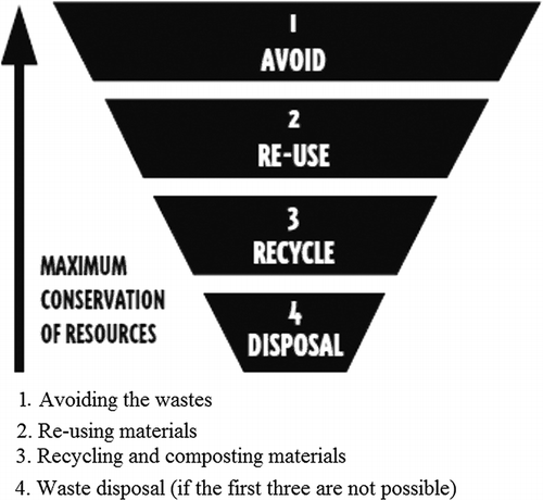
Figure 1. Hierarchy of the SW management strategies. Modified from AEPA (1996).
Spatially based methods of identification of a suitable place are developed through geotechnological resources, and this approach has increased significantly during the last two decades (CitationCarver, 1991; CitationGbanie et al., 2013). Most of the features involved in the selection of a suitable area are geographic, and one of the best forms to handle them is through the geographic information system (GIS) approaches. GIS is now widely accepted as a versatile and indispensible tool in a vast array of applications (CitationGoodchild, 2003). The resultant map shows places suitable or unsuitable for installation of a new sanitary landfill (CitationLeão et al., 2004). In suitable places, it is expected that the construction and existence of the landfill do not cause significant environmental and social damages, or that the predicted damages should be easily and quickly controllable (CitationSumathi et al., 2008; CitationBiotto et al., 2009).
In studies involving siting of suitable areas for installation landfills, GIS approaches have been developed in order to consider factors of restriction, consider different weights for different features according to considered importance, and generate a cartographic product that identify potential sites where a landfill can be installed. Other advantages in using GIS in the landfill siting practices may include selection of the objective zone exclusion process according to the set of provided screening criteria, and zoning and buffering (CitationSumathi et al., 2008).
One crucial feature to be determined is the correct sizing of the future landfill, because if this sizing is not consistent, three is a risk of the landfill be installed in an place whose space is smaller than the minimal space need for the landfill, and the managers will be obligated to interrupt the functioning of the landfill too early, shortening the life span of the landfill. Some research studies have been developed in order to help with the correct identification of suitable areas for installation of future landfill (CitationAl-Jarrah and Abu-Qdais, 2006; CitationNas et al., 2010), but in such papers the sizing is a feature not considered.
For many cities, including practically all Brazilian cities, dumping SW in open spaces is the most common solution currently (CitationZuquete et al., 2005). On the other hand, a lot of landfills are reaching their operational capacity, especially the ones located in populated municipalities. Many municipalities need to urgently choose an area for installation of new landfill(s). One of the main tasks to solve is regarding the location of such new landfills.
For the Brazilian reality, a great governmental effort is occurring, in order to minimize inadequate municipal SW disposal (CitationAlves et al., 2009). In Bauru municipality, located in São Paulo State, this is a critical problem, and the site for the development is our case study in this paper. We present a case study of a GIS-based approach for identifying problems of location of suitable areas for installation of a new landfill.
The Study Site
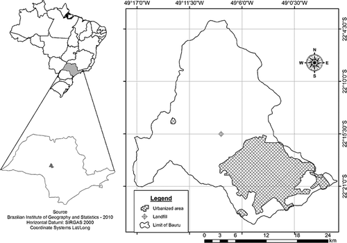
Our study was carried out considering the Bauru municipality, located in the central region of São Paulo State, southeastern Brazil. It encompasses 668 km2 and approximately 350,000 inhabitants, with 95% of them considered urban (CitationIBGE, 2010) ().
Figure 2. Location of Bauru municipality, São Paulo State.
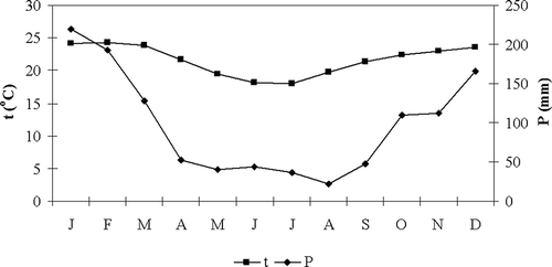
The climate is tropical. The mean annual temperature is 21.6ºC, and the mean annual rainfall height is 1,170 mm (). Winds occur predominantly from north to south (CitationFigueiredo and Paz, 2010).
Figure 3. Monthly values of temperature and rainfall for Bauru municipality (Center of Meteorological and Climatologic Researches Applied in Agriculture, 2010).
The geological basement is fully sedimentary, highly vulnerable to erosion (CitationBrannstrom and Oliveira, 2000), and encompasses an area highly vulnerable to aquifer pollution (CitationSPSES, 2010). The altimetry ranges from 300 to 600 m. The slope ranges from 10 to 20% (CitationMondelli et al., 2007). In Bauru soils occur in the classes Oxisols and Alfisols (CitationOliveira et al., 1999). The river network is dense. A lot of creeks and streams occur along the study area, as detailed later.
There are currently 29 registered wells along the municipality and they are responsible for providing approximately 60% of the consumed water (BDWS, 2012). Two airports are functioning in Bauru. One of them lies 5 km away from the urban center and is basically an airfield for private flights. The other one is newer, located 20 km away from the urban center, and it is an airport for commercial ends. The garbage collection service provides full coverage for the entire urban region and for 98.7% of the municipal population. Currently approximately 235 tons of SW is generated every day in Bauru (MEUDB, 2012).
The dump used currently is located 15 km from the urban center. Although it is considered a controlled dump because it is incorporates the main features of a sanitary landfill (CitationMondelli et al., 2007), nowadays it is considered “inappropriate,” according to current criteria established by Environmental Regulatory Agency of São Paulo State (http://www.cetesb.sp.gov.br). Currently there are four layers completely filled. An additional fifth layer is in operation. This fifth layer, as well as the landfill, is almost reaching the capacity of functioning.
Procedures
Sizing of the new landfill
In Brazil, the period of functioning of a landfill must be at least 10 years (CitationABNT, 1997). However, it is well known that activities of identification of a suitable place for the new landfill, as well as all other preliminary steps before starting the functioning of the new landfill, are extensive and time-consuming. Hence, we established here a minimal period of 15 years. We considered that the current population is 346,650 inhabitants in 2011 and the medium annual increase rate is 0.86% (computed for the period from 2000 to 2010). Thus, the predicted population for the year 2027 was estimated using the equation
Considering the start of functioning in 2013, we considered the amount of generated SW as being 0.6 kg inhabitant−1 day−1 and the specific mass 0.5 tons m−3 (MEUDB, 2012). The information generated in this estimate will be one criterion of decision in the process of chosing the area of the new landfill.
Identification of suitable areas for installation of landfill
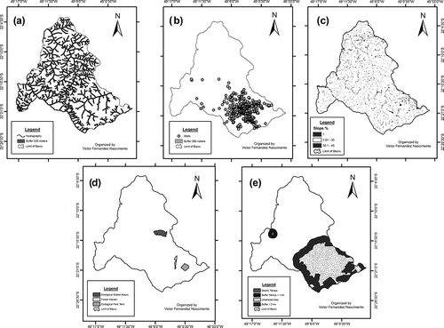
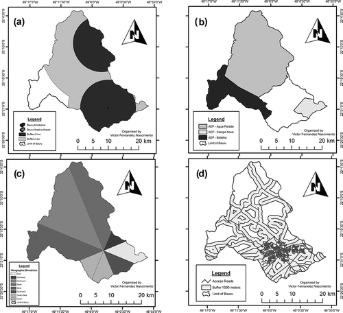
We worked with a semiexclusionary criterion based on two groups of major features. One group represents the restriction features and the other represents limitation features. The major restrictions encompass minor criteria of the physical environment, social aspects and restrictions imposed by current Brazilian legislation, and some technical restrictions imposed by the Brazilian Association for Normalization. Contemplating each restrict feature listed in , we generated a corresponding map ().
Table 1. Minor criteria considered in major restrictive for identification of suitable areas for installation of the landfill in Bauru
Figure 4. Maps depicting all restrictive features considered for study area: (a) river network, (b) wells, (c) slope map, (d) areas with ecological restrictions, and (e) buffer of urban settlements.
Regarding the major limitation, we considered the laws stated by the Brazilian Environmental Council related to landfill siting. Among the laws, there is the distance from airports, mainly due to the circulation of birds around the landfills. Such birds might cause damages in the airplanes and other airport services. There are two rules stated by Brazilian National Environmental Council related to airports (). So, we considered two situations, explained ahead.
Table 1. Minor criteria considered in major limiting for classification of areas for installation of the landfill in Bauru as being suitable or moderately suitable
The Brazilian legislation permits that the municipal or state governments outline areas named “Areas for Environmental Protection–AEP” for a determined region considered of ecological interest. For these regions, there are regulatory guidelines. Such guidelines vary regionally, according to environmental and social characteristics of the region. Such areas usually transcend the geopolitical limits of the municipalities and their size may vary. In Bauru there are parts of three AEPs ().
Figure 5. Limitation features: buffer map of airports (a), environmental protection areas (b), wind directions (c), and highway and streets network (d).
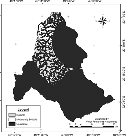
After establishing the criteria and elaborating all maps accordingly, the next step was generating the maps that identify areas considered suitable, moderately suitable, or unsuitable for installation of a new landfill. This step was also carried out through GIS analysis. The overlay was performed in order to integrate all considered layers and to identify areas that meet all criteria and to show areas that do not meet the criteria.
Results and Discussion
Landfill sizing
Considering 15 years as the period for suitable functioning of the landfill, the estimated amount of SW produced for such period is 3,822,468.4 tons. The predicted volume is 7,644,936.8 m3. Further, ABNT (the Brazilian Association of Technical Normalization) (1997) states that “in order to minimize the infiltration of water into the cell and require little maintenance, the final cover cannot present fractures. The soil of the cover should have a permeability coefficient less than the natural soil of the landfill area. The design of the cover should have a shape that avoids soil erosion.” However, the amount of material required to cover the SW is not specified in this normalization. The Municipal Enterprise of Garbage Collection of Bauru (MEUDB, 2010) recommends a topsoil cap corresponding to approximately 35% of the total of SW deposited. Hence, the total volume required for the landfill for 15 years of utilization is 9,938,417.84 m3 SW plus soil for cover.
Selection of suitable sites
We elaborated one scenario considering only the restrictive criteria (). The map shows that Bauru is a municipality where the question of installation of the new landfill is a critical problem to be deciphered. Many facts support this affirmation.
Figure 6. Scenario generated considering all restrictive and limiting features, but considering a buffer of 9 km for airports.
The first one is that the municipality is entirely located over an aquifer (CitationMondelli et al., 2007). An aquifer is considered a hydrogeologically sensitive area (CitationABNT, 1997), and Bauru is considered a critical area (CitationSPSES, 2010). On the other hand, due to the geological basement being predominantly sandy and with high vulnerability for erosion (CitationAlmeida, 1974), the regional relief is predominantly flat and 10% of the area is unsuitable for installation of the new landfill.
The occurrence of wells usually is a concern (CitationNas et al., 2010). For example, CitationMahamid and Thawaba (2010) for a Palestine region recommended a buffer of 2,000 m from the wells, and areas inside this radius cannot be considered for construction of landfills. The proximity among the landfill and the wells might make such wells unsuitable for use, because of the risk of the creation of harmful gases and leachates. Fortunately, in Bauru, of the 29 wells that occur along the municipality, 20 occur in the urbanized region, which automatically presents restrictions for landfill installation. Nine wells occur outside the urban regions, but in the inner region of the buffer zone of urban settlements.
In turn, 42% of the study area must be excluded for installation of the new landfill in this study area because of the occurrence of the river network and respective buffer zone, named Areas for Permanent Preservation (APP). APP are a concern for installation of landfills because of they encompass, simultaneously, floodplain area and regions of water quality maintenance and protection of aquatic wildlife (CitationSiddiqui et al., 1996).
The urbanized region existing in the municipal area is expressive (15% of the total area). On the one hand, it is a region that demands products and services, including garbage collection. On the other hand, in some cases it encompasses locations unsuitable for the installation of some kinds of enterprises. However, both urbanized regions and areas of ecological restrictions were fully overlaid by the first limiting feature, airports.
At least for Brazilian reality, an unusual fact that occurs in Bauru is the existence of two airports. Due to the necessity of establishment of the buffer zones, almost 88% of the municipal area presents restrictions for installation of the new landfill exclusively due to the existence of the airports (see ). According to Brazilian legislation, a radius of 20,000 or 13,000 m is considered an Area of Airport Security, according to the category of airport. In the inner region of this radius the land use must be highly controlled and one of the restrictions is the prohibition of construction of new dumps, landfills, and similar items. Comparatively, for Cleveland County, Oklahoma, a radius much shorter than in Brazil (3,050 m) was considered (CitationSidiqqui et al., 1996). For Amman municipality (Jordan), CitationAl-Jarrah and Abu-Qdais (2006) considered various scenarios, with the longest distance stipulated being 7,000 m. For Columbus, Ohio, CitationHite et al. (2001) considered 2,400 m. CitationAmbuj (2012) recommended (no site specified) a distance of 20,000 m. The Brazilian legislation does not explain the reasons for adoption of 20,000 and 13,000 m, but it is clear that this feature is highly limiting in terms of land use.
The existence of three AEPs in Bauru is another feature that is critical for limiting the installation of a new landfill. AEPs normally are extensive area, with some degree of human occupation, endowed with natural attributes, and of aesthetic and cultural importance to the quality of life and well-being of populations. Due to these reasons, some anthropogenic activities are rigorously prohibited.
Even though we do not consider other limiting features presented in that were not discussed, we observe that unsuitable areas for installation of the new landfill in Bauru are predominant. Thus, we observe that three main features were responsible for the entire area of Bauru being totally unsuitable for landfill installation: urban area and its respective buffer zones, the existence of the AEPs, and the buffer zones of the airports.
Additional features, beyond those considered in and , were not included in our modeling, because for the reported scenario, we believe that no other features would improve the scenario and “transform” unsuitable areas into suitable areas. On the other hand, we did not create other theoretical or simulated scenarios for landfills (e.g., expanding the urban area), because the realistic scenario is, by itself, clear enough to explain how complicated is the situation of destination of SW in Bauru.
Alternatives
It is clear that in Bauru there are few suitable areas for install a new landfill. If, on the one hand, it is difficult find out places for a new landfill for Bauru, on the other hand, other alternatives for SW management should be considered. Several technological alternatives exist to redirect the SW typically destined for a landfill, all having the potential to be more sustainable than disposal of SW in a landfill (CitationTroschinetz and Mihelcic, 2009). Some additional solutions are described next.
The first one is to “export” the SW to another municipality. Although this is an alternative practiced in many Brazilian municipalities (CitationBarreira et al., 2008; CitationLino et al., 2012), this is a delicate suggestion, because it would be extremely unethical for us to recommend the exportation of the SW jointly with the related problems for another place. All neighbor municipalities of Bauru have small urbanized areas and do not have airports. However, all of them are located over the same geological basement (aquifer) and might present similar problems, and some of them might encompass parts of the same AEPs that Bauru encompasses, as well as the high river network density. Studies using GIS technology are extremely useful to answer this question, and possibly this proposal is feasible to develop, at least temporarily.
The second supposition, practically impossible to happen, would be the deactivation of the commercial airport toward the legal permission of installation of the landfill. The airport located in a rural area is a well-established civil construction, and has been functioning normally since its construction. Certainly the government agencies will not consider this recommendation.
The third recommendation is making solid investments in projects of composting and recycling. Regarding composting, Bauru meets the trend of the Brazilian cities (CitationLino and Ismail, 2012), where organic matter is the predominant fraction of the SW generated daily (in 2001 the value was 89.4%). On the other hand, composting and recycling are still incipient activities in the municipality (CitationMarco et al., 2010). Such activities have enormous potential of success in terms of public policy.
Although the Brazilian legislation does not prescribe explicit prohibition of controlled forms of SW management, such as recycling and/or composting plants, either in airport security areas or in AEPs (CitationBarreira et al., 2008), we consider a buffer of 9 km around the airports as a security region and in the inner region of this radius we consider that all SW management activities should be strictly avoided. Outside this buffer, recycling and composting activities can be developed. So, considering this concern, we introduce in the map in suitable areas for such activities. The map shows areas considered suitable and moderately suitable, according to the buffer of the road network (see map “d,” ). This shows that 14.1% of Bauru has some suitability for installation of recycling and/or composting plants ().
Table 3. Percentage of occurrence of each class for the scenario generated considering all restrictive and limiting features, but considering a buffer of 9 km for airports
If composting plants were prioritized, a large amount of organic soils amendment would be generated. It is well known that the soils in Bauru are highly susceptible to erosion, mainly due their sandy texture and low amount of organic matter (CitationSilva et al., 2011). The organic material generated in the composting process could be extremely useful to minimize the problem of soil erosion in rural proprieties.
The fourth consideration, maybe the most important, is promoting investments in politics aiming at the reduction of the generation of SW. Through this option the problem could be attacked at the root. Educational programs in homes and schools, as well as economic incentives, could have some effectiveness in reduction of SW. For instance, from 2008, the municipal SW management staff in Beijing City, a municipality much bigger than Bauru, has focused on reduction and resource conservation. Incineration and composting will gradually substitute for sanitary landfill (CitationZhen-shan et al., 2009).
Certainly, the best solution for Bauru is the integrated solutions for management of SW (). Coincidentally, a municipal committee was recently created in Bauru with the goal to create a municipal plan for integrated SW management in Bauru (CitationMPB, 2012). Notifying this committee that the installation of a new landfill in Bauru is not possible is critical for making future decisions. The creation of this committee is in concordance with the national Brazilian politics of SW management.
Figure 7. Flowchart of the steps of the general process of reduction in order to minimize the amount of SW destined to landfill. Dashed lines correspond to materials that could be sent directly to plants for composting or recycling, due to high quality (desirably).
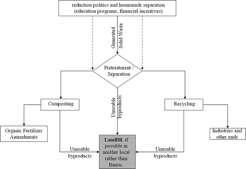
The point is that the problem remains due to a lack of overall responsibilities. Furthermore, the elaboration and permanent updating of a database elaborated in order to guide decisions regarding alternatives to landfilling, such as recycling, combustion, or composting, and pretreatment of waste prior to landfilling, are a general problem that exists also in our study area. Similarly, there is need for a longer term view of not only these other technologies, but also landfill practices and trends (CitationHam, 1993).
Conclusion
GIS was confirmed to be a versatile tool because it permitted us to internalize general rules, for example, incorporation of maps of slope and riparian zones, as well as to internalize local specific rules, for example, incorporation of maps regarding Areas for Environmental Protection. GIS permitted working in both exclusionary and semiexclusionary approaches. Through GIS tools we reached the important and apparently “hard” conclusion, that is, the existence of few suitable areas for installation of a new landfill in Bauru. Hence, we strongly encourage the use of this technology for identification of suitable areas for installation of future landfills worldwide, as well as simulations and additional predictions, when necessary.
In Bauru it is expected that there will be a generation of 3,822,468.4 tons or 7,644,936.8 m3 of SW over the next 15 years. As seen previously, due to environmental and legal restrictions or limitations, it is hard to find areas actually suitable for the construction of a new landfill. Considering the reality found here, the most sensible solution is making massive investments in alternative modalities of SW management, rather than disposal SW in landfill(s).
However, the local decision makers should interpret the finding reported here as an excellent opportunity to make investments in creative and sustainable solutions for SW management, rather than think, think, and think solutions, in order to find suitable areas for a future landfill inside the municipal area of Bauru or revisiting aspects of the legislation to find an escape point in the laws that would enable the installation of a new landfill.
This study is a pioneer in discovering this important scenario for the countryside of São Paulo State. There is a high probability of other cities being in a situation similar to that reported for Bauru. Hence, as strategy, changing the destination of the SW is a high-priority topic to be developed at municipal and state scales of government.
References
- ABNT [Brazilian Association of Technical Normalization] . 1997 . NBR 13986—Aterros de resíduos não perigosos—Critérios para projeto, implantação e operação , Rio de Janeiro , RJ : ABNT .
- Al-Jarrah , O. and Abu-Qdais , H. 2006 . Municipal solid waste landfill siting using intelligent system . Waste Manage , 26 : 299 – 306 . doi: 10.1016/j.wasman.2005.01.026
- Almeida , F.F.M. 1974 . “ Série Teses e Monografias n. 14 ” . In Fundamentos geológicos do relevo paulista , São Paulo-SP : IG-USP .
- Alves , M.C.M. , Lima , B.S.L.P. , Evsukoff , A.G. and Vieira , I.N. 2009 . Developing a fuzzy decision support system to determine the location of a landfill site . Waste Manage. Res , 27 : 641 – 51 .
- Ambuj , P. 2012 . Sustainable landfill practices and appropriate disposal of solid waste in urbanisation process . J. Environ. Res. Dev , 7 ( 1A ) : 444 – 51 .
- Australian Environmental Protection Authority. 1996. Environmental guidelines: Solid waste landfillsaccessed October, 2012 http://www.environment.nsw.gov.au/resources/waste/envguidlns/solidlandfill.pdf (http://www.environment.nsw.gov.au/resources/waste/envguidlns/solidlandfill.pdf)
- Barreira , L.P. , Phillip , A. , Rodrigues , M.S. and Tenório , J.A.S. 2008 . Physical analyses of compost from composting plants in Brazil . Waste Manage , 28 : 1417 – 22 . Jr doi: 10.1016/j.wasman.2007.05.023
- Bauru Department of Water and Sewage Collecting and Treatment. 2012accessed February 15, 2012 http://www.daebauru.sp.gov.br/site2006/index2.php (http://www.daebauru.sp.gov.br/site2006/index2.php)
- Biotto , G. , Silvestri , S. , Gobbo , L. , Furlan , E. , Valenti , S. and Rosselli , R. 2009 . GIS, multi criteria and multi-factor spatial analysis for the probability assessment of the existence of illegal landfills . International J. Geogr. l Information Sci , 23 ( 10 ) : 1233 – 44 .
- Brannstrom , C. and Oliveira , A.M.S. 2000 . Human modification of stream valleys in the western plateau of São Paulo, Brazil: Implications for environmental narratives and management . Land Degradation Dev , 11 : 535 – 48 .
- Brazilian Countryside Ministry . 1980 . Portaria Minter n 124, de 2 de agosto de 1980. Estabelece normas para a localização de indústrias potencialmente poluidoras junto às coleções hídricas http://www.mma.gov.br/port/conama/processos/61AA3835/LivroConama.pdf
- Brazilian National Environment Council . December 12 1995 . “ Dispõe sobre Área de Segurança Aeroportuária–ASA. Diário Oficial da República Federativa do Brasil, Brasília, DF. Page number 20,388 ” . In Resolução 04 do Conselho Nacional de Meio Ambiente—CONAMA de 9 de outubro de 1995 December 12 ,
- Carver , S. 1991 . Integrating multi-criteria evaluation with geographical information systems . Int. J. Geogr. Information Systems , 5 : 321 – 39 .
- Center of Meteorological and Climatologic Researches Applied in Agriculture. 2010. Climatological database for municipalities of São Paulo Stateaccessed March 2010 http://www.cpa.unicamp.br/outras-informacoes/clima-dos-municipios-paulistas.html (http://www.cpa.unicamp.br/outras-informacoes/clima-dos-municipios-paulistas.html)
- Figueiredo , J.C. and Paz , R.S. 2010 . “ Paper presented at the XVI Brazilian Congress of Meteorology, Belém, Pará ” . In Nova classificação climática e o aspecto climatológico da cidade de Bauru/São Paulo Brazil.
- Gbanie , S.P. , Tengbe , P.B. , Momoh , J.S. , Medo , J. and Kabba , V.T.S. 2013 . Modelling landfill location using geographic information systems (GIS) and multi-criteria decision analysis (MCDA): Case study Bo, Southern Sierra Leone . Appl. Geogr , 36 : 3 – 12 . doi: 10.1016/j.apgeog.2012.06.013
- Goodchild , M.F. 2003 . Geographic information science and systems for environmental management . Annu. Rev. Environ. Resources , 28 : 493 – 519 . doi: 10.1146/annurev.energy.28.050302.105521
- Ham , R.K. 1993 . Overview and implications of US sanitary landfill practice . Air Waste , 43 ( 2 ) : 187 – 190 .
- Hite , D. , Chern , W. , Hitzhusen , F. and Randall , A. 2001 . Property-value impacts of an environmental disamenity: the case of landfills . J. Real Estate Finance Econ , 22 ( 2–3 ) : 185 – 202 . doi: 10.1023/A:1007839413324
- IBGE [Brazilian Institute for Geography and Statistics]. 2010. Demographic sense 2010accessed February 2012 http://www.censo2010.ibge.gov.br (http://www.censo2010.ibge.gov.br)
- Leão , S. , Bishop , I. and Evans , D. 2004 . Spatial–temporal model for demand and allocation of waste landfills in growing urban regions . Computers Environ. Urban Systems , 28 ( 4 ) : 353 – 85 .
- Lim , J.S. and Missios , P. 2007 . Does size really matter? Landfill scale impacts on property values . Appl. Econ. Lett , 14 ( 10 ) : 719 – 23 .
- Lino , F.A.M. and Ismail , K.A.R. 2012 . “ Analysis of the potential of municipal solid waste in Brazil ” . In Environ. Dev 4: 105–113.
- Mahamid , I. and Thawaba , S. 2010 . Multi criteria and landfill site selection using GIS: A case study from Palestine . Open Environ. Eng. J , 3 : 33 – 41 . doi: 10.2174/1874829501003010033
- Marco , R.M.F. , Battistele , R.A.G. and Castro , R. 2010 . A gestão dos resíduos sólidos no município de Bauru–SP . Gespros J , 5 ( 1 ) : 159 – 69 .
- Mondelli , G. , Giacheti , H.L. , Boscov , M.E.G. , Elis , V.R. and Hamada , J. 2007 . Geoenvironmental site investigation using different techniques in a municipal solid waste disposal site in Brazil . Environ. Geol , 52 ( 5 ) : 871 – 87 . doi: 10.1007/s00254-006-0529-1
- Municipal Enterprise for Urban Development of Bauru. 2012. Aterro sanitário de Bauru–caracterizaçãoaccessed October 2012 http://www.emdurb.com.br (http://www.emdurb.com.br)
- Municipal Prefecture of Bauru . 2008 . Participative Municipal Master Plan of Bauru Municipal law 5631 of August 22 http://cdn.intechopen.com/pdfs/23108/InTech-Natural_potential_for_erosion_for_brazilian_territory.pdf
- Municipal Prefecture of Bauru. 2012. Municipal law number 11.895, of July 19 of 2012accessed October 2012 http://www.bauru.sp.gov.br/arquivos/sist_diariooficial/2012/07/do_ 20120724_2129.pdf (http://www.bauru.sp.gov.br/arquivos/sist_diariooficial/2012/07/do_ 20120724_2129.pdf)
- Nas , B. , Cay , T. and Iscan , F. 2010 . Selection of municipal solid waste landfill site for Konya, Turkey using GIS and multi-criteria evaluation . Environ. Monit. Assess , 160 : 491 – 500 . doi: 10.1007/s10661-008-0713-8
- Oliveira , J.B. , Camargo , M.N. , Rossi , M. , Calderano Filho , B. and EMBRAPA–Solos . 1999 . Mapa Pedológico do Estado de São Paulo , Rio de Janeiro : Expanded legend. Campinas: Instituto Agronômico .
- ReVellea , C.S. and Eiseltb , H.A. 2005 . Location analysis: A synthesis and survey . Eur. J. Operational Res , 165 ( 1 ) : 1 – 19 .
- São Paulo State Environment Secretary. 2010. Technical guidelines for installation of wells. Resolution number 14, published March 5, 2010accessed October 2012 http://licenciamento.cetesb.sp.gov.br/legislacao/estadual/resolucoes/2010_Res_SMA_14.pdf (http://licenciamento.cetesb.sp.gov.br/legislacao/estadual/resolucoes/2010_Res_SMA_14.pdf)
- Sener , B. , Süzen , M.L. and Doyuran , V. 2006 . Landfill site selection by using geographic information systems . Environ. Geol , 49 : 376 – 88 .
- Sener , S. , Sener , E. , Nas , B. and Karagüzel , R. 2010 . Combining AHP with GIS for landfill site selection: a case study in the Lake Beyşehir catchment area—Konya, Turkey . Waste Manage , 30 ( 11 ) : 2037 – 46 . doi: 10.1016/j.wasman.2010.05.024
- Siddiqui , M.Z. , Everett , J.W. and Vieux , B.E. 1996 . Landfill siting using geographic information systems: A demonstration . J. Environ. Eng , 122 ( 6 ) : 515 – 23 . doi: 10.1061/(ASCE)0733-9372(1996)122:6(515)
- Silva , A.M. , Alvares , C.A. and Watanabe , C.H. 2011 . “ Natural potential for erosion for Brazilian territory ” . In Soil Erosion, Book 2 , Edited by: Godone , G. and Stanchi , S. Rijeka , Croatia : Intech. . Ined http://hotsite.bauru.sp.gov.br/planodiretor/ (in Portuguese).
- Sumathi , V.R. , Natesan , U. and Sarkar , C. 2008 . GIS-based approach for optimized siting of municipal solid waste landfill . Waste Manage , 28 : 2146 – 60 . doi: 10.1016/j.wasman.2007.09.032
- Troschinetz , A.M. and Mihelcic , J.R. 2009 . Sustainable recycling of municipal solid waste in developing countries . Waste Manage , 29 : 915 – 23 . doi: 10.1016/j.wasman.2008.04.016
- Vasiloglou , V.C. 2004 . New tool for landfill location . Waste Manage. Res , 22 : 427 – 39 .
- Zhen-shan , L. , Lei , Y. , Xiao-Yan , Q. and Yu-mei , S. 2009 . Municipal solid waste management in Beijing City . Waste Manage , 29 : 2596 – 99 . doi: 10.1016/j.wasman.2009.03.018
- Zuquette , L.V. , Palma , J.B. and Pejon , O.J. 2005 . Environmental assessment of an uncontrolled sanitary landfill . Bul. Eng. Geol. Environ , 64 : 257 – 71 .