
Abstract
Exposures to mobile source air toxics (MSATs) have been associated with numerous adverse health effects. While thousands of air toxic compounds are emitted from mobile sources, members of a subset of compounds are considered high priority due to their significant contribution to cancer and noncancer health risks and the contribution of mobile sources to total exposure as evaluated by the U.S. Environmental Protection Agency (EPA) National-Scale Air Toxics Assessments (NATA). These pollutants include benzene, 1,3-butadiene, ethylbenzene, acrolein, acetaldehyde, formaldehyde, naphthalene, polycyclic organic matter, and diesel particulate matter/organic gases. This study provided year-long trends of benzene, 1,3-butadiene, acrolein, acetaldehyde, and formaldehyde in Las Vegas, NV. Results indicated that MSAT concentrations often did not exhibit trends typical of other primary emitted pollutants in this study. Instead, other mobile sources beyond the highway of interest contributed to the measured values, including a major arterial road, a large commercial airport, and a nearby parking lot. The data were compared with relevant census-tract NATA estimates, with estimated ambient 1,3-butadiene concentrations similar to the measured values. Measured benzene values were much lower relative to the NATA total ambient benzene concentrations. Measured acrolein values were much higher relative to the NATA total acrolein concentrations. Measured acetaldehyde and formaldehyde values were also higher relative to the NATA total acetaldehyde and formaldehyde concentrations for all wind conditions and downwind conditions. Some possible explanations for these differences include nearby sources influencing the measured values; meteorological influences that may not be well captured by the NATA modeling regime; chemical reactivity of measured compounds; and additional explanatory variables may be needed for certain urban areas in order to accurately disaggregate anthropogenic air toxics emissions.
Implications: Comparison of air toxics concentrations measured at four long-term near-road sites in Las Vegas, NV, show generally good agreement with the CitationEPA 2005 NATA total ambient concentrations. Measured concentrations did not compare as well with CitationEPA 2005 NATA for the on-road mobile portion of the ambient concentrations. This highlights the complexity of air toxic emission sources and impacts in urban areas, especially around large highway facilities; NATA's inability to capture local-scale meteorology and fine-scale ambient gradients; and that additional explanatory variables may be needed for certain urban areas in order to accurately disaggregate anthropogenic air toxics emissions.
Introduction
Thousands of air toxic compounds are emitted from mobile sources. Of these thousands of compounds, a subset of pollutants are considered higher priority mobile source air toxics (MSATs) based on the CitationU.S. Environmental Protection Agency (EPA) 2005 National-Scale Air Toxics Assessment (NATA), including benzene, 1,3-butadiene, acrolein, acetaldehyde, and formaldehyde. Since highways and other large roadways are ubiquitous in the United States and many other countries in the world, with a large portion of the population spending significant time in this environment, understanding how NATA results compare with air toxic concentrations near large roadways aids in understanding the populations’ overall health risks from air toxic exposures.
MSATs have been shown at ambient concentrations and exposures over extended periods of time to contribute to numerous health effects, including cancer, cardiovascular, eye irritation, and respiratory symptoms and reproductive problems (Health Effects Institute Citation[HEI], 2007; CitationHEI, 2010). Current estimates indicate that approximately 45 million people in the United States live within 100 m of a four-lane highway, railroad, or airport (EPA, 2010b). Susceptible populations, including children, have been shown to be especially vulnerable to the detrimental effects of air pollution (CitationMejía et al., 2011). Numerous factors are important when evaluating the impacts of “near-road” (i.e., within 300 m of a roadway) air pollution, including spatial gradient, roadway type, traffic volume, meteorology, and diurnal and seasonal climate variations (Karner et al., 2010; CitationZhou and Levy, 2007).
Benzene, 1,3-butadiene, acrolein, acetaldehyde, and formaldehyde are formed by incomplete gasoline and diesel fuel combustion. Benzene may be directly emitted during vehicle refueling operations (CitationHEI, 2007). The principal emission sources of benzene and 1,3-butadiene are on-road vehicle emissions. Approximately half of the benzene emissions nationwide are due to highway vehicles. In urban counties, approximately half of 1,3-butadiene emissions are due to highway vehicles (CitationHEI, 2007).
Nationally, acetaldehyde emissions from on-road mobile sources account for approximately one-third of the total primary emissions for this pollutant (CitationHEI, 2007; EPA, 2013). Photochemical processes, with photooxidation of volatile organic compounds (VOCs), are an important contributor to ambient concentrations of acetaldehyde and formaldehyde (CitationLuecken et al., 2012), with more than 80% of the ambient concentrations of these pollutants due to this secondary formation (CitationLuecken et al., 2006). Sources of formaldehyde include both biogenic (formed in living cells) and anthropogenic (e.g., highway vehicle exhaust, biomass burning, etc.) ones, with motor vehicles contributing approximately 4% of the nationwide formaldehyde emissions ( EPA, 2012).
Approximately 14% of acrolein emissions are from motor vehicle exhaust. In addition, photochemical oxidation is an important source of acrolein as well as motor vehicle exhaust. Due to the reactivity of precursor compounds such as 1,3-butadiene and the reactivity of acrolein through photochemical oxidation as well as measurement limitations, ambient air monitoring data is sparse for this compound. Measurement issues include interferences with NO2 and stability of 2,4-dinitrophenylhydrazine (DNPH) (CitationHEI, 2007). Further discussion of the contribution of motor vehicles and other sources to benzene, 1,3-butadiene, acrolein, acetaldehyde, and formaldehyde emissions is provided in the supplemental materials.
Due to the health concerns associated with near-road air quality, the EPA, in collaboration with the Federal Highway Administration (FHWA), embarked upon a year-long research study to characterize the spatial and temporal impacts of highway vehicle emissions in a near-road environment (CitationKimbrough et al., 2013a; CitationKimbrough et al., 2013b). Previous near roadway air quality studies have generally been conducted over short-time durations (days to months) and mostly focused on criteria pollutants (see Karner et al., 2010). This paper analyzes data from a year-long study conducted in Las Vegas, NV, and compares measured 1,3-butadiene, benzene, acrolein, acetaldehyde, and formaldehyde ambient air concentrations with predicted concentrations from the CitationEPA 2005 NATA. Results of criteria pollutant concentrations from this study have been previously reported (CitationKimbrough et al., 2013b).
Methods
Study design, location, topography, and meteorological conditions
This research study collected continuous and integrated ambient air quality samples for a wide variety of species in Las Vegas, NV from mid-December 2008 to mid-December 2009 (CitationKimbrough et al., 2013b). The study was conducted as a collaborative effort between the U.S. Department of Transportation's Federal Highway Administration (FHWA) and the EPA. The general study design and location resulted from a legal challenge and subsequent settlement agreement between the Sierra Club and FHWA. The legal challenge concerned the proposed widening of US 95 in Las Vegas, NV, a major freeway running through the city with >150,000 annual average daily traffic (AADT). A monitoring protocol was developed through multiagency collaboration (CitationFHWA, 2006), and included continuous and integrated measurement methods, as well as other parameters of interest (e.g., traffic, meteorology). CitationKimbrough et al. (2013a) describes the complete set of air pollutants measured in this study, which included the following parameters relevant to this paper: 1,3-butadiene, benzene, acrolein, acetaldehyde, formaldehyde, wind speed, wind direction, temperature, humidity, solar radiation, and precipitation (CitationKimbrough et al., 2013b).
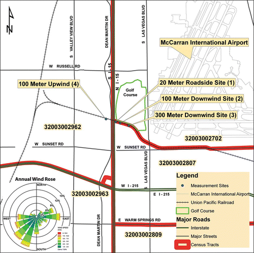
The volatile organic compound (VOC) and carbonyl measurements discussed in this paper were collected at four monitoring stations located in the vicinity of I-15: one shelter west of the highway (100 m upwind) and three shelters east (downwind) approximately 20 m, 100 m, and 300 m distant (). This section of highway, crossing under a spur of the Union Pacific Railroad (UPRR), is depressed approximately 5 m below the flanking terrain (CitationBaldauf et al., 2013). CitationBaldauf et al. (2013) reports that in general this depressed (cut) section of freeway did not significantly change pollutant concentrations or spatial gradients except during calm, light variable wind conditions. A golf course borders the measurement locations to the north; Las Vegas Boulevard flanks the easternmost edge of the measurement transect. The UPRR spur line runs from Las Vegas, NV, to Henderson, NV, and typically the train runs once in the morning to Henderson and returns in the afternoon to Las Vegas. The influence of the train's passage on the data was a concern. However, using a video camera with date and time stamp information and correlating those data with an analysis of the 5-min continuous data (carbon monoxide [CO], oxides of nitrogen [NOX], and black carbon [BC]) revealed that there were no impacts from the train. Field site operators noted that the continuous analyzer second-by-second data did show impacts due to the train's passage; the 5-min data showed negligible impacts. Thus, the MSAT data's longer integration period, that is, hourly, would not show discernible impacts from the train's passage.
Figure 1. Location of near-road monitoring stations and associated census tracts.
Analytical methods and instruments
A detailed discussion of analytical methods and instruments is provided in the supplemental material. Table S1 (supplemental) provides a summary of the instrumentation and measurements discussed herein. MSAT samples were collected using EPA standard methods: (1) TO-15 and (2) TO-11A (CitationEPA, 1999a; CitationEPA, 1999b). Nine 1-hr integrated samples were collected on a 1-in-12-day ambient air quality monitoring schedule ( CitationEPA, 2010a). Acrolein analysis was conducted using both of these methods. Table S2 (supplemental) shows a summary of canister (TO-15) and cartridge (TO-11A) samples by type.
The presence of NO2 in the sampled air can lead to the suppression of the formation of a stable derivative with the DNPH reagent used with the TO-11A method, leading to less formaldehyde extracted and measured by the laboratory analysis (HPLC). Several studies have investigated NO2 interferences when utilizing the DNPH sampling method (CitationKarst et al., 1993; CitationKomazaki et al., 1998; CitationTang et al., 2004). CitationKarst et al. (1993) reported NO2 interferences, while CitationKomazaki et al. (1998) and CitationTang et al. (2004) did not report NO2 interferences. A comparison of diurnal traffic volume, formaldehyde concentrations, and the ratio of formaldehyde/NO2 suggested no interferences from NO2 occurred during the study (see supplemental material for more detail and Figure S1).
Meteorology
Meteorologically complex, the Las Vegas urban area is located in the southwestern United States. The city is located in a valley bounded by mountains that rise approximately 1000 to 2000 m above the valley floor. The complex topography contributes to the complex meteorological conditions that exist in the Las Vegas area. Winds are predominately from the southwest; however, seasonal variations may be observed (CitationKimbrough et al., 2013b; Clark County Department of Air Quality & Environmental Management [DAQEM], 2007). An annual wind rose is shown in .
For this analysis, four wind directional categories were established: (1) downwind (winds from the west; 210–330° with wind speeds > 1 m/s), (2) upwind (winds from the east; 30–150° with wind speeds > 1 m/s), (3) parallel (wind from the north/south; 150–210° or 330–360°/0–30° with wind speeds > 1 m/s), and (4) low and variable (wind speeds < 1 m/s). (CitationKimbrough et al., 2013b). Use of these four meteorological categories allows for a comparison of near-road pollutant concentrations for conditions relevant to predictions from air quality transport and dispersion models.
Nearby sources of air toxic compounds
Las Vegas is an atypical city in the United States. Las Vegas is a major recreation and resort destination. As such, the city's economy, unlike many other cities, has little heavy industry. A review of the 2011 Toxics Release Inventory (TRI) Explorer indicated two potential nearby sources of air toxics (CitationEPA, 2011b). Further cross-referencing these sources with the 2005 NATA ( CitationEPA, 2005) revealed that emission sources were a light-industrial manufacturing facility engaged in creating custom light fixtures and an asphalt batch plant. The 300-m downwind site was located approximately 240 m north-northwest of the custom light fixture manufacturing facility. The 100-m upwind site was located approximately east-southeast of the asphalt manufacturing facility. According to the TRI, these facilities did not emit compounds that were measured during the field campaign. Thus, traffic sources likely dominated the MSAT concentrations reported in this paper.
In addition to I-15, other traffic sources that may have influenced the MSAT measurements include Las Vegas Boulevard, approximately 200 m east of the 300-m downwind site, and a parking lot just south of the 100-m and 300-m downwind sites. Las Vegas Boulevard supported approximately 50,000 vehicles/day during the study, and would likely only influence measurements during winds from the east. Commuter traffic typically exhibits a bimodal distribution due to home-to-work and work-to-home commute patterns. However, Las Vegas traffic data exhibited a trimodal traffic distribution, believed to be the result of several factors: (1) Las Vegas is not typical commuter city; (2) Las Vegas is a recreation destination for many travelers; (3) shift changes in Las Vegas are later or earlier in the day, depending on the employer; (4) the study site is along an interstate that carries both inter- and intrastate traffic; and (5) this interstate supports freight movement as part of the North American Free Trade (NAFTA) corridor. Please refer to supplemental material, Figure S2, for average hourly speed and volume information. The parking lot was a staging area for truck deliveries to the Las Vegas Convention Center. Thus, trucks would remain at the parking lot for multiple days at a time. Thus, activity in the parking lot would have variable effects on study measurements. Las Vegas's McCarran International Airport (western property boundary) is also located approximately 430 m east of the 300 m downwind site. Impacts on MSAT concentrations from the airport would likely only occur during winds from the east.
National-Scale Air Toxics Assessment (NATA)
The National-Scale Air Toxics Assessment (NATA) contains emission estimates for 177 of the 187 air toxics listed in the Clean Air Act (CitationEPA, 2005). Estimates are developed for each county using the National Emission Inventory (NEI), a national point, area, and mobile source inventory of anthropogenic emission sources in the United States (CitationEPA, 2008b). These county-level emission estimates are allocated to census tracts using roadway miles as a surrogate for primary and secondary roads (population is used as the surrogate for local roads) and are then input to a dispersion model to estimate ambient air concentrations at each census-tract centroid. The point and mobile source modeling for NATA was conducted with the Human Exposure Model-3, AERMOD; nonpoint sources were estimated using the Assessment System for Population Exposure Nationwide (ASPEN) model; and finally, secondary formation was predicted using the Community Multiscale Air Quality (CMAQ). More information on how NATA predicts ambient levels can be found in a NATA Technical Methods Document (CitationEPA, 2011a). A summary of NEI emissions for the United States and Clark County (Las Vegas), NV is shown in the supplemental material, Table S3.
Uncertainties associated with this process of developing local-scale NATA concentrations include the various models used for the process, pollutant reactivity data, speciation data, inputs to the models including the NEI, allocation factors used to disaggregate national- or state-level data to the county level, and others (CitationEPA, 2005). Thus, comparisons between NATA and measured concentrations may be problematic.
Only a few studies have reported comparisons between NATA and measured concentrations (CitationGeorge et al., 2011; CitationLogue et al., 2011; CitationLupo and Symanski, 2009; CitationPayne-Sturges et al., 2004; CitationEPA, 2005). Of these, the results reported in CitationLogue et al. (2011) provide an evaluation of long-term results and CitationGeorge et al. (2011) provides the most rigorous evaluation of personal exposures to date. Results reported in CitationGeorge et al. (2011) indicated good agreement between measured ambient benzene concentrations (Detroit, MI) versus modeled benzene concentrations. CitationLogue et al. (2011) compared measured ambient air toxics concentrations with modeled concentrations for Pittsburg, PA. This comparison, which included 1,3-butadiene, benzene, acrolein, acetaldehyde, and formaldehyde, reported that NATA underpredicted air toxics concentrations for the Pittsburg, PA, area. CitationLupo et al. (2009) reported measured versus modeled concentrations for 1,3-butadiene and benzene in Texas. This study reported relatively good agreement between measured versus modeled concentrations for benzene although poor agreement for 1,3-butadiene. The CitationPayne-Sturges et al. (2004)study utilized passive sampling, personal badges, and indoor and outdoor badges as the means for collecting exposure measurements in Baltimore, MD. This study reported relatively good agreement between measured versus modeled concentrations for benzene. An CitationEPA (2008a) evaluation of benzene measured-to-modeled concentrations reported results to be within a factor of 2. Typically when measured-to-modeled concentrations occur within a factor of 2, the results are considered to have good agreement (CitationEPA, 2008a).
Previous studies that compared measured values to modeled NATA values used neighborhood and urban scale measurements, or exposure samples representing multiple scales. For this analysis, measured near-road air toxics results are compared with NATA results for selected census tracts in Las Vegas, NV. Since highways and other large roadways are ubiquitous in the United States and many other countries in the world, with a large portion of the population spending significant time in this environment, understanding how NATA results compare with air toxic concentrations near large roadways aids in understanding the populations’ overall health risks from air toxic exposures.
Statistical assumptions
Primarily median values are presented herein for the measured concentrations; however, mean values are reported as well. Median value is defined as the “midpoint” value of a data set. Fifty percent of the values are above the median, and 50% of the values are below the median. Typically, median values are more appropriate than mean values when discussing data that are not normally distributed or to mitigate the influence of outliers (CitationOtt, 1995).
Multiple statistical software programs including openair, R, SAS JMP, and SigmaPlot were utilized for the data analysis presented in this paper (CitationCarslaw and Ropkins, 2011; CitationR Development Core Team, 2011; CitationSAS, 2011).
Results and Discussion
A comparison of Las Vegas measurements collected during this study with national average MSAT concentrations indicated comparable levels for 1,3-butadiene, acetaldehyde, and acrolein, with benzene concentrations in Las Vegas lower than the national average and formaldehyde levels slightly higher than the national average. The national ambient air MSAT concentrations and Las Vegas measurement values are shown in .
Table 1. VOC and carbonyl—Averages for all wind directions and winds from west (12/15/2008–12/15/2009) and national ambient air concentrations for selected MSATs (CitationEPA, 2010c)
Comparison with NATA results required identification of the relevant census tracts. These census tracts are identified in and and , and are based on the Census 2000 data (CitationEPA, 2005; CitationU.S. Census Bureau, 2000). The 100-m upwind site was located in census tract 32003002962. The 20-m, 100-m, and 300-m downwind sites were located in census tract 32003002807. These two census tracts as well as adjacent census tracts are shown in . shows the NATA total annual average ambient concentrations and total on-road mobile annual average ambient concentrations for adjacent census tracts relative to census tracts with measurement stations (CitationEPA, 2005). shows the NATA total annual average ambient concentrations for these census tracts as well as measured concentrations for the 100-m upwind and the 20-m, 100-m, and 300-m downwind sites for all wind conditions. Also shown in are the NATA total annual on-road mobile average ambient concentrations for the relevant census tracts, as well as measured concentrations for the 100-m upwind and 20-m, 100-m, and 300-m downwind sites for downwind conditions (winds from west). The assumption is that the measured concentration values for the “all wind conditions” case should be compared to NATA total annual average ambient concentration values, whereas measured concentration values for the downwind conditions (winds from west) should be compared to the NATA total annual on-road mobile average ambient concentration values. The basis for these assumptions is the wind direction data collected during the study. Under all wind conditions (i.e., all wind directions and wind speeds), the study sites are measuring urban background concentrations as well as emissions from on-road sources or other nearby sources such as the airport, adjacent parking lot, and so on. Under downwind conditions (winds from west), the strongest “signal” is coming from on-road sources—the study sites are measuring emissions from on-road sources.
Table 2. NATA total annual average ambient concentrations and total on-road mobile annual average ambient concentrations for adjacent census tracts relative to census tracts with measurement stations (CitationEPA, 2005)
Table 3. NATA total annual average ambient concentrations and total on-road mobile annual average ambient concentrations (CitationEPA, 2005) versus measured (100 m) upwind and downwind ( 20 m, 100 m, and 300 m) concentrations and mean ambient measured concentrations across three downwind sites for all wind conditions and downwind conditions (winds from west)
The analysis discussed in this paper compares the 2005 NATA results (the most recent NATA assessment available) with measurements collected in Las Vegas during the 2009 calendar year. As reported in the “National Air Toxics Program: The Second Integrated Urban Air Toxics Report to Congress”, ambient concentrations of 1,3-butadiene, benzene, acetaldehyde, and formaldehyde are decreasing across the country. The report indicates ambient concentrations of 1,3-butadiene and benzene from 2005 to 2008 decreased approximately 20–30%, while ambient concentrations of acetaldehyde and formaldehyde from 2005 to 2008 decreased approximately 10–15% (EPA, in review).
Air quality—Integrated 1-hour samples—VOC
Spatial gradient results
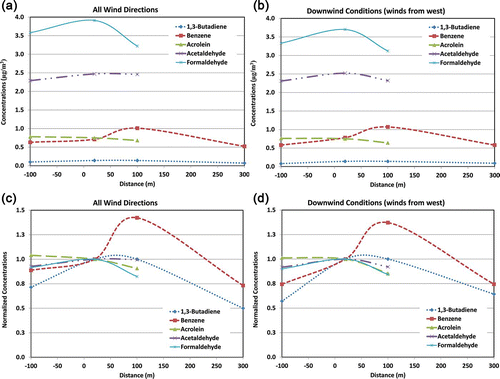
shows the number of observations, median, average, and 95% confidence intervals for the VOC (TO-15 method) and carbonyl (TO-11A method) data. Median values for 1,3-butadiene are approximately the same at the 20-m roadside site (Station 1) and the 100-m downwind site (Station 2) for all wind conditions (0.08 μg/m3), while values at the 300-m downwind site were 50% lower (0.04 μg/m3). Median values for 1,3-butadiene at the 20-m roadside site are approximately 18% lower than at the 100-m downwind site, but approximately 125% higher than at the 300-m downwind site under downwind conditions (winds from west). Higher than expected median benzene concentrations were observed at the 100-m downwind site than at the 20-m roadside site, with the 20-m roadside site approximately 39% lower than the 100-m downwind site under all wind conditions, although median values at the 20-m roadside site are approximately 44% higher than at the 300-m downwind site under all wind conditions. Median values for benzene were similar under downwind conditions (winds from west) as well.
A definitive reason as to why the 100-m site showed higher than expected pollutant concentrations for 1,3-butadiene and benzene is problematic. While likely nearby sources of these pollutants have been identified, according to the TRI none of these stationary facilities emitted these compounds. It is possible that these emissions may be coming from an uninventoried source not included in the 2005 NATA emissions inventory or from a source that is newer than the 2005 inventory. Another possible explanation would be if there were sample collection issues such as media contamination prior to sample collection. Field blanks and field controls were prepared and deployed during the sampling campaign. Laboratory analysis of these field blanks and field controls indicted that media contamination was not an issue during the field study.
Mean concentration gradients and normalized concentration gradients for each pollutant for all sites for all wind conditions and downwind conditions only (winds from west) are shown in , , , nd 2d. The mean for each pollutant is normalized to the relevant concentration at Station 1 ( and ). The mean for each pollutant is normalized to the relevant concentration at Station 1 to clarify the spatial gradient, as the data values for some of the pollutants, notably 1,3-butadiene, are an order of magnitude smaller than the data values for the other pollutants. As shown in , the spatial concentration gradient is not well defined for acrolein and acetaldehyde. Moreover, the normalized mean 1,3-butadiene and benzene concentrations for the 100-m downwind site are higher than for the 20-m site. These results do not indicate that a significant concentrations gradient existed within approximately 100 m of the highway, although the MSAT concentrations did decrease between 100 and 300 m from the highway. Since most studies suggest that background concentrations occur by approximately 300 m from the road, comparisons of the Las Vegas measurements with NATA results can be differentiated by “near-road” (within 100 m) and background (farther than 300 m) from the road. However, other sources may be influencing these results, such as the adjacent parking lot or secondary formation of these pollutants via photoxidation.
Figure 2. Mean carbonyl and VOC concentration gradients for each pollutant. (a) All sites and all wind conditions. (b) All sites for downwind conditions (winds from west). (c) Normalized mean carbonyl and VOC concentration gradients, normalized to Station 1 for each pollutant for all sites and all wind conditions. (d) All sites for downwind conditions (winds from west). Normalized means for each site shown in (c) and (d) were calculated as follows: VPS/VPs1, where V = average value, p = pollutant, s = site, s1 = site 1.
Comparison with NATA
shows the number of observations, median, average and 95% confidence intervals for the VOC data (TO-15 method). Average measured 1,3-butadiene and benzene values at Sites 1, 2, and 3 (20, 100, and 300 m downwind) compare well with the NATA predicted annual average ambient 1,3-butadiene and benzene concentrations for the relevant census tracts (summarized in ). Generally, the NATA data compare best with the measurements at the 20-m and 100-m downwind sites for both ambient and on-road NATA concentration predictions. The NATA data compare less well with the 300-m downwind site for both ambient and on-road NATA concentration predictions.
These results suggest that the NATA modeling for ambient air concentrations did account for the increased concentrations of 1,3-butadiene and benzene that can be present near large roadways, since gradients for these compounds tend to be smaller than for other criteria pollutants such as CO, as discussed in the following section. Results for the upwind census tract and monitoring site suggested that the measurements were comparable to the ambient NATA predictions, and higher than the on-road NATA predictions for 1,3-butadiene, while measurements were lower than predicted NATA ambient concentrations (although within a factor of 2) and higher than predicted NATA on-road concentrations for benzene. These results highlight that near-road concentrations consist of a combination of background concentrations including secondarily formed pollutant concentrations and the impact of the nearby traffic emissions, suggesting that ambient air NATA predictions likely best represent near-road exposures.
Air quality—Integrated 1-hour samples—Carbonyl
Spatial gradient results
shows the number of observations, median, average, and 95% confidence intervals for the carbonyl data (TO-11A method). Values are not reported for Station 3 for all carbonyls due to instrument issues throughout the course of the study. Average and median measurement values for acrolein are similar across all sites for all wind conditions and downwind conditions only, although the measurements are a factor of 10 or greater than the NATA predicted ambient and on-road concentrations (summarized in ). Higher median concentrations of acetaldehyde and formaldehyde were observed at the 20-m downwind site than at the 100-m upwind and downwind sites for all wind conditions and downwind conditions, suggesting an influence of traffic emissions on air quality concentrations even with high background levels and the formation of these compounds by secondary reactions. However, the mean normalized concentrations for acrolein, acetaldehyde, and formaldehyde show very little spatial gradient change ().
Comparison with NATA
For acetaldehyde and formaldehyde, the measurements at all sites compare well with the NATA total annual average ambient concentrations predictions; however, the NATA on-road contributions do not agree well with measured values, as shown in . The carbonyl results also suggest that ambient air NATA predictions accurately reflected the contribution of highway emissions on near-road MSAT exposures. These results also suggest that the NATA on-road ambient concentrations may not account sufficiently for the contribution of background concentrations to the on-road predicted pollutant levels. Moreover, most ambient levels of carbonyls are secondarily formed and are not due to sources of primary emissions.
Summary
This paper examines long-term trends of measured near-road MSAT concentrations and compares these data with modeled 2005 NATA results. These VOC (1,3-butadiene, benzene) and carbonyl (acrolein, acetaldehyde and formaldehyde) measurements were collected during a field study in Las Vegas, NV, from mid December 2008 through mid December 2009. While the data comparison is for different years, 2005 NATA results versus 2009 measured data, this would tend to suggest that the measured values should be lower than the NATA results. The “National Air Toxics Program: The Second Integrated Urban Air Toxics Report to Congress” indicates that in general ambient concentrations of 1,3-butadiene, benzene, acetaldehyde, and formaldehyde are decreasing across the country (EPA, in review). It is not known whether these trends are occurring at the monitoring location. In other cases, differences may also be attributable to uncertainties within the NATA modeling regime (i.e., inventories, meteorology), as well as to uncertainties with ambient measurement techniques. Spatial gradients for the MSATs measured were not as pronounced as other pollutants measured in this study (see Kimbrough et al., 2013) and reported in the literature (see Karner et al., 2010). Formaldehyde had the largest absolute gradient under all wind conditions and for only downwind conditions ( and ), while 1,3-butadiene and benzene had the largest relative gradients when examining normalized concentrations based on the 20 m measurements ( and ). However, average concentrations of benzene were higher at the 100-m downwind site, suggesting that other sources, such as the adjacent parking lot, contributed to emissions of this pollutant ().
Comparing NATA predictions of 2005 MSAT concentrations to the measured values indicated that the ambient air concentration predictions provided better estimates than the on-road predicted values. In most instances, the median measured values of these pollutants were within a factor of 2 when compared with the NATA modeled predictions for ambient air. The main exception was acrolein, which had measured values more than 10 times the predicted concentrations. Given uncertainties in the sample collection and analysis of acrolein, as well as uncertainties in existing emission inventories, this result might be expected. In addition, the on-road predicted NATA concentrations were significantly lower than the measurements, suggesting that the on-road emissions may be characterized in NATA under both the background and secondary formation bins. Thus, it may be more appropriate to compare monitored levels to total NATA ambient predictions.
Acknowledgment
The authors thank members of the EPA Near-Road team for their contributions to this project, Richard Shores and Cary Croghan of EPA Office of Research and Development; ARCADIS; Alion and American Ecotech for shelter/instrument operation support. The authors thank Donald Whitaker of EPA Office of Research and Development, a key contributor to the success of the integrated sampling component of this project.
Supplemental Materials
Supplemental data for this article can be accessed at www.tandfonline.com/uawm.
Disclaimer
This document has been reviewed in accordance with U.S. Environmental Protection Agency policy and approved 590 for publication. Mention of trade names or commercial products does not constitute endorsement or recommendation for use. The views expressed in this journal article are those of the authors and do not necessarily reflect the views or policies of the U.S. Environmental Protection Agency.
Supplemental_Material.docx
Download MS Word (6.7 MB)References
- Baldauf , R. W. , Heist , D. , Isakov , V. , Perry , S. , Hagler , , G. S. W. , Kimbrough , S. , Shores , R. , Black , K. and Brixey , L . 2013 . Air quality variability near a highway in a complex urban environment . Atmos. Environ. , 64 ( 0 ) : 169 – 78 . doi: 10.1016/j.atmosenv.2012.09.054
- Carslaw , D. and Ropkins , K. 2011 . openair: . Open-source tools for the analysis of air pollution data Version R package version , : 0.5 – 11 . http://www.openair-project.org
- Clark County Department of Air Quality & Environmental Management . 2007 . Annual network plan report , Las Vegas , NV : Clark County Department of Air Quality & Environmental Management .
- Federal Highway Administration . 2006 . Detailed monitoring protocol for U.S. 95 settlement agreement. , Washington , DC : FHWA .
- George , B.J. , Schultz , B.D. , Palma , T. , Vette , A.F. , Whitaker , D.A. and Williams , R.W. 2011 . An evaluation of EPA's National-Scale Air Toxics Assessment (NATA): Comparison with benzene measurements in Detroit, Michigan . Atmos. Environ , 45 ( 19 ) : 3301 – 8 . doi: http://dx.doi.org/10.1016/j.atmosenv.2011.03.031
- Health Effects Institute. 2007. Mobile-source air toxics: A critical review of the literature on exposure and health effects. Health Effects Institute. Boston, MA http://pubs.healtheffects.org/view.php?id=282 (http://pubs.healtheffects.org/view.php?id=282)
- Health Effects Institute. 2010. Traffic-related air pollution: A critical review of the literature on emissions, exposure, and health effects. Health Effects Institute. Boston, MA http://pubs.healtheffects.org/view.php?id=306 (http://pubs.healtheffects.org/view.php?id=306)
- Karner , A.A. , Eisinger , D.S. and Niemeier , D.A. Near-roadway air quality: Synthesizing the findings from real-world data . Environmental Science & Technology , 44 ( 14 ) 5334 – 44 . doi: 10.1021/es100008x
- Karst , U. , Binding , N. , Cammann , K. and Witting , U. 1993 . Interferences of nitrogen dioxide in the determination of aldehydes and ketones by sampling on 2,4-dinitrophenylhydrazine-coated solid sorbent [in English] . Fresenius J. Anal. Chem , 345 ( 1 ) : 48 – 52 . doi: 10.1007/bf00323325
- Kimbrough , E.S. , Baldauf , R.W. and Watkins , N. 2013a . Seasonal and diurnal analysis of NO2concentrations from a long-duration study conducted in Las Vegas, Nevada . J. Air Waste Manage. Assoc , 63 ( 8 ) : 934 – 42 . doi: 10.1080/10962247.2013.795919
- Kimbrough , S. , Baldauf , R. , Hagler , G. , Shores , R. C. , Mitchell , W. , Whitaker , D. A. , Croghan , C. W. and Vallero , D. A. 2013b . Long-term continuous measurement of near-road air pollution in Las Vegas: Seasonal variability in traffic emissions impact on local air quality . Air Qual. Atmos. Health , 6 ( 1 ) : 295 – 305 . doi: 10.1007/s11869-012-0171-x
- Komazaki , Y. , Narita , Y. and Tanaka , S. 1998.Development of an automated measurement system using a diffusion scrubber and high-performance liquid chromatography for the monitoring of formaldehyde and acetaldehyde in automotive exhaust gas [in English] . Analyst , 123 ( 11 ) 2343 – 49 . doi: 10.1039/A805999C
- Logue , J. M. , Small , M.J. and Robinson , A.L. 2011 . Evaluating the national air toxics assessment (NATA): Comparison of predicted and measured air toxics concentrations, risks, and sources in Pittsburgh, Pennsylvania . Atmos. Environ. , 45 ( 2 ) : 476 – 84 . doi: http://dx.doi.org/10.1016/j.atmosenv.2010.09.053
- Luecken , D.J. , Hutzell , W.T. and Gipson , G.L. 2006 . Development and analysis of air quality modeling simulations for hazardous air pollutants. . Atmos. Environ. , 40 ( 26 ) : 5087 – 96 . doi: http://dx.doi.org/10.1016/j.atmosenv.2005.12.044
- Luecken , D.J. , Hutzell , W.T. , Strum , M.L. and Pouliot , G.A. 2012 . Regional sources of atmospheric formaldehyde and acetaldehyde, and implications for atmospheric modeling . . Atmos. Environ. , 47 ( 0 ) : 477 – 90 . doi: http://dx.doi.org/10.1016/j.atmosenv.2011.10.005
- Lupo , P.J. and Symanski , E. 2009 . A comparative analysis of modeled and monitored ambient hazardous air pollutants in Texas: a novel approach using concordance correlation [in English] . J. Air Waste Manage. Assoc , 59 ( 11 ) : 1278 – 86 . doi: 10.1097/01.ede.0000339590.78459.c1
- Mejía , J.F. , Choy , S.L. , Mengersen , K. and Morawska , L. 2011 . Methodology for assessing exposure and impacts of air pollutants in school children: Data collection, analysis and health effects - A literature review . Atmos. Environ , 45 ( 4 ) : 813 – 23 . doi: 10.1016/j.atmosenv.2010.11.009
- Ott , W. 1995 . Environmental Statistics and Data Analysis , Boca Raton , FL : Lewis .
- Payne-Sturges , D.C. , Burke , T.A. , Breysse , P. , Diener-West , M. and Buckley , T.J. 2004 . Personal exposure meets risk assessment: A comparison of measured and modeled exposures and risks in an urban community [in English] . Environ. Health Perspect , 112 ( 5 ) : 589 – 98 .
- R Development Core Team . 2011 . R: A Language and Environment for Statistical Computing, Version 2.13.1 , Vienna , Austria : R Foundation for Statistical Computing .
- SAS Institute, Inc . 2011 . . JMP Version 10.0.0 , Cary , NC : SAS Institute Inc .
- Tang , S. , Graham , L. , Shen , L. , Zhou , X. and Lanni , T. 2004 . Simultaneous determination of carbonyls and NO2 in exhausts of heavy-duty diesel trucks and transit buses by HPLC following 2,4-dinitrophenylhydrazine cartridge collection . Environ. Sci. Technol , 38 ( 22 ) : 5968 – 76 . doi: 10.1021/es0353356
- U.S. Census Bureau. 2000. Census data and maps(accessed December 12, 2012) http://www.census.gov (http://www.census.gov)
- U.S. Environmental Protection Agency. 1999a. Compendium of methods for the determination of toxic organic compounds in ambient air, 2nd ed.,Compendium method TO-15 determination of volatile organic compounds (VOCs) in air collected in specially-prepared canisters and analyzed by gas chromatography/mass spectrometry (GC/MS). Office of Research and Development. Cincinnati, OH http://entechinst.com/pdf/EPAto-15ar.pdf (http://entechinst.com/pdf/EPAto-15ar.pdf)
- U.S. Environmental Protection Agency. 1999b. Compendium of methods for the fetermination of toxic organic vompounds in ambient air, 2nd ed., Compendium method TO-11A determination of formaldehyde in ambient air using adsorbent cartridge followed by high performance liquid chromatography (HPLC) [active sampling methodology]. Office of Research and Development. Cincinnati, OH http://entechinst.com/pdf/EPAto-15ar.pdf (http://entechinst.com/pdf/EPAto-15ar.pdf)
- U.S. Environmental Protection Agency. 2005. National Air Toxics Assessments (NATA)(accessed December 7, 2012) http://www.epa.gov/ttn/atw/natamain/index.html (http://www.epa.gov/ttn/atw/natamain/index.html)
- U.S. Environmental Protection Agency. 2008a. Comparison of ASPEN modeling system results to monitored concentrations(accessed February 18, 2013) http://www.epa.gov/ttnatw01/nata/draft6.html (http://www.epa.gov/ttnatw01/nata/draft6.html)
- U.S. Environmental Protection Agency. 2008b. National emissions inventory(accessed March 28, 2013) http://www.epa.gov/ttnchie1/net/2008inventory.html (http://www.epa.gov/ttnchie1/net/2008inventory.html)
- U.S. Environmental Protection Agency. 2010a. Ambient air monitoring schedule 2010(accessed January 3, 2010) http://www.epa.gov/ttn/amtic/files/ambient/pm25/CALENDAR_2010.pdf (http://www.epa.gov/ttn/amtic/files/ambient/pm25/CALENDAR_2010.pdf)
- U.S. Environmental Protection Agency . 2010b . Primary National Ambient Air Quality Standards for nitrogen dioxide , Washington , DC : U.S. Government Printing Office . 40 CFR Parts 50 and 58
- U.S. Environmental Protection Agency. 2010c. Report on the environment(accessed July 30, 2012) http://www.epa.gov/ncea/roe (http://www.epa.gov/ncea/roe)
- U.S. Environmental Protection Agency . 2011a . An overview of methods for EPA's National-Scale Air Toxics Assessment, ed. Office of Air Quality Planning and Standards , NC : Research Triagnle Park .
- U.S. Environmental Protection Agency. 2011b. Toxics Release Inventory(accessed April 5, 2013) http://www.epa.gov/tri/ (http://www.epa.gov/tri/)
- U.S. Environmental Protection Agency. 2012. National Emissions Inventory (NEI) air pollutant emissions trends data(accessed August 12, 2013) http://www.epa.gov/ttnchie1/trends (http://www.epa.gov/ttnchie1/trends)
- U.S. Environmental Protection Agency. 2013. Mobile source air toxics(accessed August 26, 2013) http://www.epa.gov/otaq/toxics.htm (http://www.epa.gov/otaq/toxics.htm)
- U.S. Environmental Protection Agency. In review . National Air Toxics Program: The second integrated urban air toxics report to Congress , Durham , NC : Office of Air Quality Planning and Standards .
- Zhou , Y. and Levy , J. 2007 . Factors influencing the spatial extent of mobile source air pollution impacts: A meta-analysis . BMC Public Health , 7 ( 1 ) : 89 doi: 10.1186/1471-2458-7-89