
Abstract
Kolkata is one of the four major metropolitan cities in India and the capital city of the state of West Bengal. With an area of 187.33 km2 and a population of about 10 million (including a floating population of about 6 million), the city generates about 3500 Metric Ton (MT) of solid waste per day. Currently, Kolkata Municipal Corporation (KMC) disposes its waste at Dhapa (21.47 ha), where the disposal rate exceeds 3000 MT/day, and at Garden Reach (3.52 ha), where the disposal rate is 100 MT/day. Considering the exhaustion of Dhapa land space, city planners are urgently searching for an alternate disposal ground. National Environmental Engineering Research Institute (NEERI), under the sponsorship of Central Pollution Control Board (CPCB), has brought out literature developing the site selection criteria for municipal solid waste disposal ground to suit Indian conditions. The developed criteria encompass environmental conditions, accessibility, geological and hydrogeological conditions, and ecological and societal effects. This paper attempts to locate the most suitable site for disposal of KMC area solid waste using the multicriterion decision analysis as stipulated in CPCB 2003 guidelines and the overlay analysis of geographic information system (GIS).
Implications:
The paper is based on landfill site selection for dumping of solid waste generated within Kolkata Municipal Corporation (KMC) area. The methodology uses GIS/remote sensing, Site Sensitivity Index (an offshoot of pairwise comparison technique developed in CPCB 2003 guidelines, Government of India), and the Delphi technique. Dhapa landfill site, where solid waste of KMC area is currently being disposed, is exhausted; the authors of this article thus found it relevant to carry out a research on the selection of an alternative landfill site. The study undertaken was comprehensive, yet presented in a lucid way so that policymakers will find easy to comprehend.
Introduction
Kolkata has an area of about 187.33 km2 and a population of about 10 million (including floating population). Kolkata Municipal Corporation (KMC) comprises 15 “boroughs” and 141 electoral “wards”; each borough consisting of a cluster of wards. It currently generates a total of 3500 Metric Ton (MT) of solid waste per day. At present, total collection points are around 662, including 228 container points, 46 direct loading, and 388 vat points/open space. As per National Environmental Engineering Research Institute (NEERI) Citation2005 report, the waste has the following characteristics listed in .
Table 1. Physical and chemical characteristics of municipal solid waste in Kolkata during 2005
From the vat/container points both departmental (i.e., KMC) and private vehicles pick up the daily garbage and transport it to the disposal ground (Chattopadhyay et al., Citation2009). A mechanized compost plant of 700 t/day capacity was installed at Dhapa by KMC in April 2000 in collaboration with M/s Organic Fertilisers (India) Pvt. Ltd. and M/s Excel Industries. However, the plant is almost nonfunctional now, owing to the high fraction of inert materials in the commingled waste.
In Kolkata, the major disposal ground is Dhapa (21.47 ha), located in the eastern side of the city. It receives about 3000 MT of solid waste per day. Another site at Garden Reach (3.52 ha) receives about 100 MT of solid waste per day. Both the sites practice open dumping, without any liner/leachate management facility or gas management system. Waste is simply spread at the landfilling sites by the dumpers without any compaction. KMC spends 70–75% of its total budgetary allocation on collection of solid waste, 25–30% on transportation, thus leaving a meager 5% on final disposal (Chattopadhyay et al., Citation2009). About 10% of disposed waste is recycled by rag pickers who carry out their activities at vat points and landfill sites in an unorganized, unhygienic way, without any government support. As of now, there is no source segregation system in KMC area. Large amount of recyclables can be removed at the source points itself, if source segregation is practiced. This saves cost of transportation, saves land space used up in landfill, and promotes successful treatment of solid waste.
With the exhaustion of Dhapa landfilling site, municipal engineers are focusing their attention on selecting an alternate landfilling site at the earliest. However, with the increased population density and urban infrastructure, several key considerations are to be taken into account to ensure its overall sustainability, and optimized siting and operations. Siting decisions are governed by the preexisting land use dynamics of the urban areas as well as the nature of the potential interactions of the landfill with the environment, and geological, hydrogeological, and socioeconomic parameters of the adjoining area. The locations must comply with the requirements of existing governmental regulations (as stipulated in Central Public Health and Environmental Engineering Organisation [CPHEEO] Manual on Municipal Solid Waste Management [2000] and Central Pollution Control Board [CPCB] Citation2003 guidelines) and at the same time must minimize economic, environmental, health, and social cost (Sumathi et al., Citation2008).
Theory and Methodology
CPHEEO, Government of India, in its Manual on Municipal Solid Waste Management (May 2000) has listed the locational criteria of landfill site selection.
CPCB (February 2003) literature has selected a set of 32 attributes for calculating an integrated index, known as Site Sensitivity Index (SSI) for ranking municipal solid waste landfill sites. The selected attributes are grouped into seven categories—accessibility, receptor, environmental, socioeconomic, waste management practices, and climatological and geological criteria. Each of the 32 attributes has an individual sensitivity index. The index scale ranges from 0 (indicating no or very less potential hazard) to 1 (indicating highest potential hazard). Thus, for each attribute a four-level sensitivity scale (0–0.25, 0.25–0.5, 0.5–0.75, and 0.75–1.0) has been considered. The site sensitivity value for each attribute needs to be selected through the Delphi technique. CPCB Citation2003 literature has already assigned fixed weights to each category, in accordance with its importance, based on pairwise comparison technique. Within a category, the weights of each attribute have also been assigned by CPCB (Citation2003) following the same procedure of pairwise comparison. The researchers endeavor to locate the best landfill site for Kolkata City, abiding by the guidelines and parameters laid down by CPHEEO (Citation2000) and CPCB (Citation2003). The method is well illustrated in the calculations of SSI of potential candidate sites (shown later in this paper).
The siting of a solid waste landfill must involve processing of a significant amount of spatial data, regulations, and acceptance criteria, as well as an efficient correlation between them. In recent years, geographic information system (GIS) has emerged as a very important tool for land use suitability analysis. GIS can recognize, correlate, and analyze the spatial relationship between mapped phenomena, thereby enabling policymakers to interlink disparate sources of information, perform sophisticated analysis, visualize trends, project outcomes, and strategize long-term planning goals (Sumathi et al., Citation2008). With the evolution of remote sensing and GIS techniques, several researchers have focused their application in a multicriterion decision analysis situation such as landfilling site selection. The researchers include Natesan and Suresh (Citation2002), Patil et al. (Citation2002), Nishanth et al. (Citation2010), Raghupati (Citation1999), Sener et al. (Citation2010), Despotakis and Economopoulos (Citation2007), Yagoub and Buyong (Citation1998), and Kara and Doratli (Citation2012).
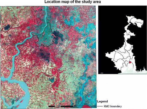
The present study attempts to locate the most suitable landfill site for solid waste generated in Kolkata City, following the laid down guidelines in CPCB (Citation2003) and CPHEEO manual (CPHEEO, Citation2000) based on a multicriterion decision analysis (SSI) and overlay analysis of GIS. A study area including KMC area and parts of adjoining North and South 24 Parganas districts bounded by 88°E to 88°45′E and 22°N to 22º45′N was selected, within which potential landfilling sites need to be located. It is quite natural that the densely populated, built-up area of KMC does not have any vacant land area for waste disposal; thus, the search of landfill areas had to be concentrated on the adjoining districts of Kolkata—North and South 24 Parganas. The western fringe of Kolkata is bounded by the river Hoogly; it was decided that wastes will not be transported over the Hooghly River to Howrah Municipal Corporation (HMC) area. Thus, the western boundary of the study area is practically demarcated by the Hoogly River. The study area is demarcated in .
Figure 1. Location map of the study area. (Left) LISS–III image with KMC area demarcated. Vegetation: dull red/pink; Settlement/towns: bluish; Water bodies: cyan, blue; Fallow land: bluish/greenish gray. (Right) Map of West Bengal showing location of Kolkata.
Size of landfilling site required
One of the primary tasks was to fix the size of the landfill site; it was decided that the site must be capable of receiving wastes for at least 30 years (from 2012 to 2041)—in order that the project becomes economically viable. To determine the area of the site, the researchers thus needed to collect and/or process the following data:
Know the fixed/resident population and the floating population within KMC area.
Collect and process data of yearly/decadal increase trends of fixed/resident and floating population and extrapolate it for next 30 years.
Collect information regarding solid waste generation rate of resident population and waste generation rate of floating population and predict their trends over a span of next 30 years.
The 1899 Calcutta Municipal Act defined the administrative domain of the municipal authority as covering 25 wards and 48.5 km2. Many boundary changes followed; the latest one being in January 1984 when boroughs XI–XV were annexed (a).
Census of India 2011 data in KMC area is shown in .
Table 2. Excerpts from Census 2011 data for KMC area
Thus, as per Census 2011, the fixed/resident population of Kolkata actually decreased by −1.88% during 2001–2011. We are assuming that the resident population will increase, at the worst, at 1% per decade during the next 30 years.
Floating population comprises (a) persons who come from nearby districts everyday and return at the end of days’ work; and (b) migrants from inside the state/outside the state/outside the country, who may stay in the city for some period of time. A large portion of the floating population hails from the adjoining districts of North 24 Parganas and South 24 Parganas. shows Census 2011 data for North and South 24 Parganas.
Table 3. Excerpts from Census 2011 data for North 24 Parganas and South 24 Parganas districts
The above trends show decrease in the population growth rate in both districts since 1991. As per Jawaharlal Nehru National Urban Renewal Mission (JNNURM) literature, City Assessment: Analysis of the Existing Situation, migrant population, which constitutes a part of floating population, has shown a decreasing trend from 1971 onwards. We assume, with time, job opportunities adjoining KMC areas will increase in the future and hence the rate of increase in floating population of KMC area is assumed to be 0.8% per year for the period of next 30 years.
CPCB Citation2003 literature (HAZWAMS/22/2002-03) has assumed rate of increase of solid waste equivalent to India’s gross domestic product (GDP) growth rate. Chattopadhyay et al. (Citation2009) depict an annual increase of municipal solid waste disposal at Dhapa by 3–5% during the past few years. An assessment report for Dhapa disposal site, Methane to Markets, prepared for KMC under the support of U.S. Environmental Protection Agency by SCS Engineers (Wayne, New Jersey, USA) in April 2010 has estimated the yearly disposal of solid waste at Dhapa dumping ground since 1981. It predicted that “the future disposal rates are assumed to increase at a rate of two percent per year starting from 2009 disposal rate of 3500 MT /day….” We assume an annual increase of 3.0% for resident population and an increase of 2% for the floating population.
As per KMC Web site, floating population within KMC area is about 5.5–6 million (including slum population of about 1.5 million), whereas fixed population is 4,580,544 (based on 2001 census). Solid waste generated per day (as per 2003 data) is 2500 MT/day. As per Ministry of Environment and Forests (MoEF) report (2009), municipal solid waste (MSW) generated in Kolkata is 2653 MT/day at 0.58 kg/capita/day during 2004–2005. Understandably, they have not considered fixed/resident and floating population separately.
Assuming that in 2011 the MSW generation rate is 450 gcpd (gram per capita per day) for resident population of 4,486,679 and 250 gcpd for floating population of 6.0 million (Chattopadhyay et al., Citation2007), the total amount of solid waste generated/day = 4,486,679 × 0.45 + 6,000,000 × 0.25 kg/day = 3519 MT/day.
Density of MSW generated is taken as 450 kg/m3 and moisture content as 46% (Chattopadhyay et al., Citation2009). Let us assume, after compaction in landfill site by bulldozers and after monsoon, the density increases to 1000 kg/m3. Based on our experience at Dhapa, landfill height is assumed as 25 m in our calculation. A continuous slope of 3 (horizontal) to 1 (vertical) has been assumed in calculating “Landfill area, cumulative, ha.” An extra 15% area has been added to the computed area for accommodating support and infrastructural facilities such as site office, access roads, workshop, etc.
The huge landfill area has been assumed to be shape of frustum of a cone (although the exact shape may be irregular), having a slope of 3:1. Let the radius at the base be R m and the radius at top r m. Formula for volume of frustum is V = 1/3пh(R2 + r2 + Rr), where R is the bottom radius and r is the top radius. Input V = 62,717,220,000 kg/1000 kg/m3 = 6,2717,220 m3; r = (R − 75) m; h = 25 m. Solving the equation for volume, R = 918 m. Hence, base area = пR2 = 2,646,948 m2 = 264 ha. Taking 1 % extra area for vehicle workshop, site offices, etc., total area required for 30 years’ landfilling comes out at 300 ha (see ). Thus, we would require an area of about 300 ha for disposal of solid waste from 2012 to 2041.
Table 4. Calculation of landfill area required for disposal of solid waste for a period of 30 years
We are not incorporating the contribution of any waste treatment plant in our calculation, since no such plant is functional as on date.
Preparation of thematic map layers
Survey of India toposheets (1:50,000) were used as base maps. Various layers of thematic maps were extracted, digitized, and analyzed in ArcGIS environment (list of map layers created is given in ). A coordinate system was chosen and all maps were georeferenced first so as to make overlay analysis possible at a subsequent stage. However, considering the fact that these Survey of India toposheets dates back to 1950s to 1980s, updating of various thematic layers had to be carried out using
Table 5. Map layers created
Google Earth: Google Earth images were used to update the thematic layers extracted from Survey of India toposheets.
Bhuvan/Indian Space Research Organisation (ISRO) Web site: Point/Line/Polygon features can be digitized directly from Bhuvan Web site and converted to shapefiles automatically. This was used in some cases for modifying/updating layers in ArcGIS.
Wikimapia: This Web site also provided valuable data in modifying/updating the thematic layers extracted from Survey of India maps.
Thematic map layers were extracted from Survey of India toposheets and other authentic sources (), georeferenced, clipped to the study area, digitized to a shapefile, and overlaid over one another for subsequent analysis. Relevant but detailed attribute data were included in attribute tables of all of these map layers.
Buffer maps for rivers, wetlands, critical habitat areas/reserve forest, road and rail network, floodplains, habitation, and airport were created using buffer values stipulated in “Remarks” column of and then all the buffered areas were joined. The remaining portions within the study area gave a preliminary idea about possible locations of candidate sites. A few of the thematic layers created using GIS software are shown in –.
Figure 2. Built-up settlement areas within study area.
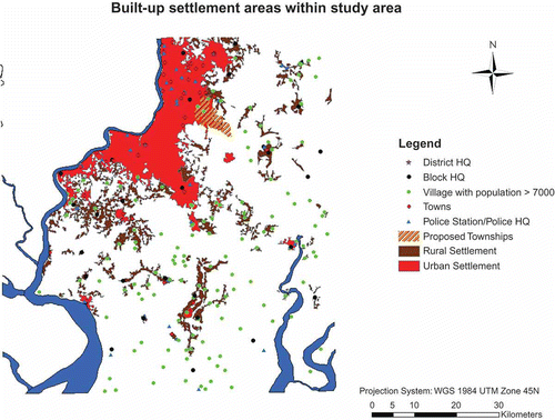
Figure 3. Depth of water table within study area.
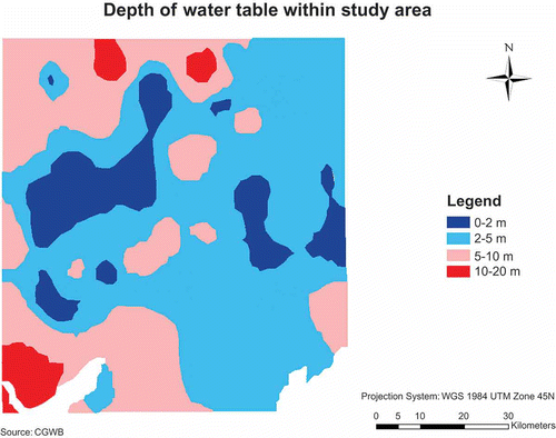
Figure 4. Land use land cover within study area.
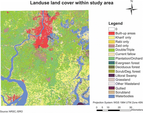
Figure 5. Rivers and wetlands within study area.
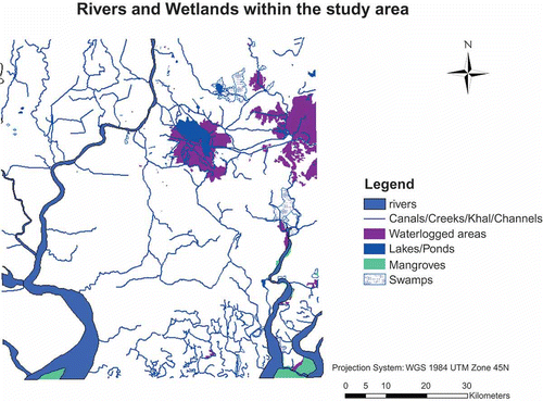
Figure 6. Airport and road-rail network within study area.
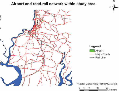
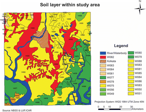
Figure 7. Soil layer within study area.
Selection of potential sites
From the analysis of the GIS map layers, four potential sites of approximately 300 ha were shortlisted based on the following factors:
Sites were near a main road.
The potential sites were selected such that they were within economical distance from point of generation.
Areas liable to floods, landslides, and earthquakes were avoided.
Areas where ground water contamination can occur in future were avoided.
Present and future land use and ease in land acquisition were taken into account.
Military exclusion zones and mineral quarries were avoided.
Potential sites were at least 20 km away from Dum Dum Airport.
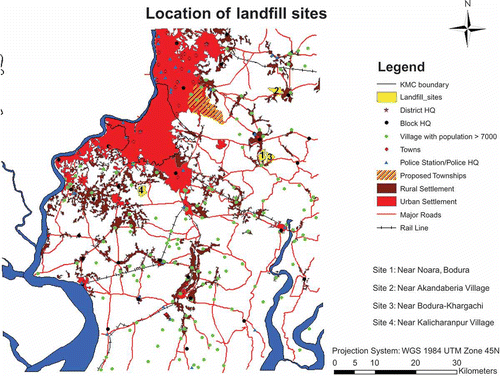
Next, visits to the four potential sites were undertaken to scrutinize the sites for detailed data (which may be required during ranking of the sites using SSI), match the GIS layers with ground truth data, and investigate possible elimination of any site(s). Photographs of the sites were taken for future reference.
Finally, comparison and ranking of the four candidate sites were carried out using SSI, as depicted in . Sensitivity index using the Delphi technique was calculated for each of the attributes using data obtained from the GIS map layers and the site visits; a panel of six specialists was involved to calculate the sensitivity index values of the attributes through the Delphi technique.
Table 6. Worksheet for ranking of sites
Results and Discussion
The site with the lowest SSI score will be less sensitive, i.e., there will be lesser impact on the environmental quality due to the disposal site and hence is the most acceptable. The site suitability will decrease with increase in total SSI score. As per CPCB 2003 guidelines, sites with <300 score are highly preferable, 300–750 moderately preferable, whereas >750 are undesirable.
As per the calculation tables, SSI of site 3 (Bodura-Khargachi) is the lowest and hence it is the most acceptable. However, site 4 is nearer to KMC area and land use land cover (LULC) data depict one-season Zaid cultivation, unlike the other sites where double/triple-crop plantation is practiced. Also site 4 is at the southern tip; thus, solid wastes of southern part of KMC area can be easily directed there.
Kolkata city spans almost 20 km north-south and 22 km east-west, having a vast network of narrow roads with vats located at various locations within the city. Most KMC-owned collection vehicles are nearly 10 years old, whereas KMC-hired vehicles are 20 years old. Under such circumstances, the option of dividing Kolkata into three zones and directing the MSW generated from each zone to three different sites—site 2, site 1/site 3, and site 4, whichever is nearer to a particular zone, can also be explored. This may reduce overall transportation costs and pollution load on the city.
The study area is densely populated (Kolkata City has a population density of 24,252 per km2; the density, however, decreases at the adjoining districts), dotted with several towns and villages; channels/creeks/swamps/marshes are common features; farming is easy and profitable due to fertile alluvial land (double/triple crop/orchards/plantations are common)—thus finding a suitable landfilling site near KMC area with total public acceptability will perhaps be impossible. Moreover, a few sites near KMC area initially thought to be promising had to be subsequently rejected, since they were found to be included within the legal boundary of East Kolkata Wetlands demarcated as per East Kolkata Wetlands (Conservation and Management) Act, 2006.
Refer to , which depicts the four shortlisted sites.
Figure 8. Location of landfill sites.
Conclusions
The study shows that GIS along with SSI, a multicriterion decision analysis technique, are valuable decision-support tools that can help policymakers locate the most suitable landfill site. GIS combines spatial data with allied quantitative, qualitative, and other attribute data, handles and correlates large volumes of complex geographic data, and links disparate sources of information. GIS coupled with remote sensing data provides an excellent framework for data capture, storage, synthesis, analysis, and display; GIS data can also be updated regularly to reflect the real-time changes of attributes within the study area.
Accuracy of GIS models depend on quality of available data; similarly, accuracy of site sensitivity index values of several environmental, geological, and hydrogeological attributes needs careful in situ site investigation tests as well as laboratory tests on samples collected from prospective sites. Thus, a geographic databank of the study area needs to be built first, followed by site investigation studies as and when needed.
Acknowledgment
The authors would like to acknowledge the support and help received from Dr. Asit Baran Ray (Emiritus Professor, Presidency College), Dr. Gupinath Bhandari (Associate Professor, Jadavpur University), Mr. Ratnadeep Ray (Assistant Professor, Vidyasagar University), Mr. Saptarshi Mondal (Research Scholar, BIT Mesra), Mr. G.K. Sarkar, and Mr. Swapnajit Bhattacharyya.
Additional information
Notes on contributors
Koushik Paul
Koushik Paul is currently working as an assistant professor in the Department of Civil Engineering at BIT Mesra, Ranchi, India; he is also a Ph.D. scholar at Jadavpur University, Kolkata, India.
Amit Dutta
Amit Dutta is an associate professor in the Department of Civil Engineering at Jadavpur University, Kolkata, and the PhD guide of Koushik Paul.
A.P. Krishna
A. P. Krishna is Professor, Department of Remote Sensing at BIT Mesra, Ranchi, and currently the acting Registrar of the Institute. He is also the co-guide of Koushik Paul.
References
- Central Pollution Control Board, Ministry of Environment and Forests. 2003. Guidelines for the Selection of Site for Landfilling. HAZWAMS/23/2002-03. New Delhi: Central Pollution Control Board.
- Central Public Health and Environmental Engineering Organisation. 2000. Manual on Municipal Solid Waste Management, Ministry of Urban Development. New Delhi: Government of India.
- Chattopadhyay, S., A. Dutta, and S. Ray. 2007. Existing municipal solid waste management in Kolkata—Deficiencies and its solutions. J. Indian Assoc. Environ. Manage. 34:161–167.
- Chattopadhyay, S., A. Dutta, and S. Ray. 2009. Municipal solid waste management in Kolkata, India—A review. Waste Manage. 29:1449–1458. doi:10.1016/j.wasman.2008.08.030
- Despotakis, V. K., and A. P. Economopoulos. 2007. A GIS model for landfill siting. Global NEST J. 9:29–34.
- Kara, C., and N. Doratli. 2012. Application of GIS/AHP in siting sanitary landfill: A case study in Northern Cyprus. Waste Manage. Res. 30:966–980. doi:10.1177/0734242X12453975
- Ministry of Environment and Forests, Government of India. 2009. State of Environment Report India—2009. New Delhi: Government of India.
- Natesan, U., and E.S.M. Suresh. 2002. Site suitability evaluation for locating sanitary landfills using GIS. J. Indian Soc. Remote Sens. 30:261–264. doi:10.1007/BF03000369
- National Environmental Engineering Research Institute (NEERI). 2005. Comprehensive Characterization of Municipal Solid Waste at Calcutta, India. Nagpur, India: NEERI.
- Nishanth, T., M. N. Prakash, and H. Vijith. 2010. Suitable site determination for urban solid waste disposal using GIS and Remote sensing techniques in Kottayam Municipality, India. Int. J. Geomat. Geosci. 1:197–210.
- Patil, M. P., T. Subramani, S. A. Patil, and T. Chakrabarti. 2002. Multi-level screening of a proposed hazardous waste treatment and disposal facility—A case study. Environ. Monit. Assess. 76:299–309. doi:10.1023/A:1015525812854
- Raghupati, L. 1999. Remote sensing applications in siting of waste disposal facilities with special reference to hazardous wastes. In Remote Sensing Application in Applied Sciences, ed. S. Mukherjee, 141–179. New Delhi: Manak Publications.
- Sener, S., E. Sener, and R. Karaguzel. 2010. Solid waste disposal site selection with GIS and AHP methodology: A case study in Senirkent-Uluborlu (Isparta) Basin, Turkey. Environ. Monit. Assess. 173:533–554. doi:10.1007/s10661-010-1403-x
- Sumathi, V. R., U. Natesan, and C. Sarkar. 2008. GIS-based approach for optimized siting of municipal solid waste landfill. Waste Manage. 28:2146–2160. doi:10.1016/j.wasman.2007.09.032
- Vaidyanadhan, R., and R. N. Ghosh. 1993. Quaternary of the east coast of India. Curr. Sci. 64:804–816.
- Yagoub, M. M., and T. Buyong. GIS applications for dumping site selections. Paper presented at the Eighteenth Annual ESRI User Conference, San Diego, California, USA, July 27–31, 1998.