
ABSTRACT
The potential environmental effects of increased U.S. biofuel production often vary depending upon the location and type of land used to produce biofuel feedstocks. However, complete, annual data are generally lacking regarding feedstock production by specific location. Corn is the dominant biofuel feedstock in the U.S., so here we present methods for estimating where bioethanol corn feedstock is grown annually and how much is used by U.S. ethanol biorefineries. We use geospatial software and publicly available data to map locations of biorefineries, estimate their corn feedstock requirements, and estimate the feedstock production locations and quantities. We combined these data and estimates into a Bioethanol Feedstock Geospatial Database (BFGD) for years 2005–2010. We evaluated the performance of the methods by assessing how well the feedstock geospatial model matched our estimates of locally-sourced feedstock demand. On average, the model met approximately 89 percent of the total estimated local feedstock demand across the studied years—within approximately 25-to-40 kilometers of the biorefinery in the majority of cases. We anticipate that these methods could be used for other years and feedstocks, and can be subsequently applied to estimate the environmental footprint of feedstock production.
Implications: Methods used to develop the Bioethanol Feedstock Geospatial Database (BFGD) provide a means of estimating the amount and location of U.S. corn harvested for use as U.S. bioethanol feedstock. Such estimates of geospatial feedstock production may be used to evaluate environmental impacts of bioethanol production and to identify conservation priorities. The BFGD is available for 2005–2010, and the methods may be applied to additional years, locations, and potentially other biofuels and feedstocks.
Introduction
The Renewable Fuel Standard (RFS) Program, established by the Energy Policy Act of 2005 and expanded by the Energy Security Independence Act of 2007, required an increase from 9 to 36 billion gallons annually in renewable U.S. transportation fuels by 2022. The U.S. Environmental Protection Agency (EPA) administers the RFS Program and is required to assess its environmental and resource-conservation impacts. In EPA’s 2011 report to Congress, it concluded that most of the environmental impacts from biofuels likely result from the feedstock-production stage (U.S. Environmental Protection Agency, Citation2011).
To estimate the potential environmental impacts of feedstock production, it is often helpful to know where biofuel refining takes place and where feedstocks are grown. This is true for most environmental endpoints, including greenhouse gas (GHG) emissions, carbon sequestration, biodiversity, water quantity and quality, and soil quality. For example, converting land currently unfarmed (e.g., Conservation Reserve Program lands) to intensive feedstock production, compared with using land already in agricultural production, can increase loss of soil carbon and nitrogen (Fargione et al., Citation2008; Searchinger et al., Citation2008) and increase impacts to air, soil, and water quality (U.S. Environmental Protection Agency, Citation2011; Gelfand et al., Citation2011; Fargione et al., Citation2008). Water use also varies substantially by location. Growing corn feedstock and refining it into ethanol uses a substantial amount of water (e.g., Chiu and Wu, Citation2012; Wu et al., Citation2012; Wu et al., Citation2014). The impact on groundwater levels depends greatly on where the corn is grown. In Iowa, for example, corn tends to be rain-fed, whereas corn in Nebraska tends to be irrigated. In short, knowing the locations of where biofuel feedstocks are produced allows a more detailed evaluation of their environmental footprint.
The purpose of this study was to produce and evaluate a method for creating a spatially-explicit database of estimated annual locations and quantities of corn grown in the United States as bioethanol feedstock—a database (the Bioethanol Feedstock Geospatial Database, or BFGD) that is publicly available for future research and application. We produced the BFGD for the years 2005–2010. We emphasize that our methods propose one way of estimating where and how much corn is being grown for bioethanol feedstock, and they assess only the potential for ethanol biorefineries to acquire substantial corn feedstock from local sources. EPA, other agencies, industry, stakeholders, or academic researchers could use the BFGD to perform future environmental analyses (e.g., O’Hare et al., Citation2009; Plevin and Mueller, Citation2008).
Project approach
Identifying potential feedstock supply
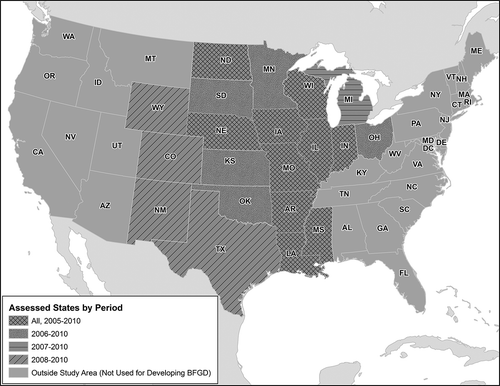
To develop the BFGD, we used data from 20 states () in and around the U.S. Great Plains and Midwest regions that produce most of the corn in the United States and contain most of the U.S. ethanol biorefineries (e.g., 94% of corn production and 90% of ethanol biorefineries in 2010). From among these 20 states, the set of states used in each year of our assessment (2005 to 2010) fluctuated based on the annual availability of information on the locations of corn fields. We obtained these annual locations of corn fields using the U.S. Department of Agriculture (USDA) Cropland Data Layer (CDL) (U.S. Department of Agriculture, Citation2011a) for each year 2005 to 2010. The CDL is a remotely sensed “Census by Satellite” geospatial product that undergoes quality-assurance measures to typically achieve a reported 85–95% accuracy rate for corn, though data sources and processing methods can vary by state and year. The CDL’s geographic coverage varies for the years used in this study—the 2005 CDL generally covered states along the Mississippi River (all of which we used in our assessment), while the 2009 and 2010 CDLs covered all 48 contiguous states (20 of which we used in our assessment). We assumed the CDL’s “corn” category to be primarily field corn and the only type of corn suitable for bioethanol production. This corn can have multiple uses, including animal feed (which is the primary endpoint) but also including bioethanol feedstock. We assumed all of this corn was available for possible use as bioethanol feedstock.
Figure 1. States included in the Bioethanol Feedstock Geospatial Database.
The CDL is a raster data set identifying crop type for square pixel areas either 30 m or 56 m on a side, depending on the year and location. Our approach assigned all corn harvested from each pixel to either bioethanol or nonbioethanol use. To reduce computational complexity, we grouped into polygons any contiguous CDL pixels of corn and mixed-crop categories including corn. Some such polygons were many kilometers long on their major axis, which complicated our approach and computations for modeling feedstock procurement by individual biorefineries in ways that did not necessarily improve the model (see the “Mapping biorefinery feedstock supply areas” section). To reduce this complexity, we further delimited all corn-field polygons by roadways. We hereafter refer to these polygons as “farm areas,” though they do not reflect actual farm property boundaries. For the purposes of our model, we assumed farm-management decisions about the ultimate disposition of the harvest are made for the farm areas rather than for individual corn-farming pixels.
USDA’s Crops/Stocks Survey reports the annual bushels of corn produced per county (U.S. Department of Agriculture, Citation2011b). The Crops/Stocks Survey samples fewer than 10% of U.S. farms and uses statistical programs to gauge trends in farming in between Agricultural Censuses, which occur every 5 years. Using the Crops/Stocks Survey, we estimated the corn production of each farm area by multiplying the county-level production by the ratio of the farm’s area to the total corn-farming area in the county.
Infrequently, the Crops/Stocks Survey lacked corn production data for a county where corn farming was indicated by the CDL. Such discrepancies might result from gaps in the Crops/Stocks Survey data or the approach for developing the CDL. In these situations, we assumed corn production took place and estimated the county’s corn production using the average production per unit area of the other corn-producing counties in the state. If a state lacked corn production data for a given year, such as with New Mexico in 2010, we estimated production using the production per unit area from the closest available year for that state.
Estimating annual feedstock demand at ethanol biorefineries
After identifying areas of potential feedstock supply, we estimated feedstock demand from biorefineries identified as producing bioethanol in one or more years in 2005–2010 (see biorefinery counts presented in ). In this subsection, we discuss the methods and data sources we used to identify and locate the biorefineries and to estimate their demand for corn feedstock, including why it was necessary to identify biorefineries and production levels nationwide before evaluating feedstock demand from biorefineries in our study area.
Table 1. Count of corn-ethanol biorefineries, nationwide and in our study area, by year.
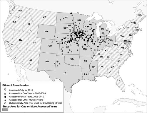
Because the U.S. Energy Information Administration (EIA) withholds refinery-level data to protect confidential business information, we used biorefinery-level data published by two trade organizations: the Renewable Fuels Association (RFA) and BBI International. For each year of this study, we used the annual RFA Industry Outlook publications (Renewable Fuels Association, Citation2015) to obtain the city/state location, feedstock types, and anticipated production and/or capacity amounts of hundreds of ethanol biorefineries nationwide. RFA forecasts each biorefinery’s annual production and capacity data from surveys at the beginning of the year. We excluded the fewer than 30 biorefineries per year that did not (for all study years) provide bioethanol capacity or production data or did not list corn among their known feedstocks.
The annual, nationwide counts of corn-ethanol biorefineries (i.e., ethanol biorefineries using corn as part or all of their feedstock) are shown in the second column of , and their locations are plotted in . We reviewed the plotted locations to insure accuracy by querying the coordinates of the facilities in our study area directly from dynamically generated maps from BBI International’s Ethanol Producer Magazine (Ethanol Producer Magazine, Citation2011). We also geocoded the city/state locations for the fewer than 10 biorefineries not in the BBI maps. Lastly, we used aerial imagery, company websites, and Web searches as final refinements of the biorefinery locations in our study area.
Figure 2. Locations of ethanol biorefineries used to develop the Bioethanol Feedstock Geospatial Database.
Data from the RFA Industry Outlooks served as the basis for estimating each biorefinery’s annual fuel production, which in turn was the basis for estimating feedstock demand. We used facility-specific fuel-production amounts when available in the RFA Industry Outlooks. Fuel-production amounts were unavailable prior to 2009, when biorefineries generally were operating at capacity, and were unavailable for some biorefineries in 2009 and 2010 as well. In these cases, we used reported fuel-production capacities, which may overestimate actual production. When neither production nor capacity data were available for a given year for a given biorefinery, we used the biorefinery’s production or capacity amount from the nearest year, preferring a subsequent year over a prior year and preferring production data over capacity data. This nearest-year estimation made use of 2011 data as well, as it was the latest year available at the time of this study. In making these other-year substitutions, we assumed each biorefinery had relatively steady production or capacity amounts from year to year. In actuality, available data show production and capacity amounts can differ between years for some biorefineries. For example, production changed from 2009 to 2010 at 25 biorefineries (out of a total of 147 biorefineries nationwide with production data available for both years), and the median change at those 25 biorefineries was 15% (with larger changes exceeding 100%). Capacity changed from any one year to another year at 83 biorefineries (out of the 208 biorefineries nationwide), and the median change at those 83 biorefineries was 45% (with larger changes exceeding 100%). In a given year, fuel-production or fuel-capacity data were unavailable for 2–30% of the biorefineries.
To make an initial estimate of bioethanol production specifically from corn feedstock, we examined the feedstocks reported for each biorefinery nationwide. Some reported using only corn. For the 5–10% of biorefineries nationwide using a mix of corn and other feedstocks in a given year, or that did not specify any feedstock, we assumed half the bioethanol was derived from corn. We used this assumption so corn-feedstock estimates for this small number of biorefineries were biased neither for nor against corn. The resulting initial estimate of annual, national production of bioethanol from corn feedstocks, using data from the RFA Industry Outlooks and the assumptions just discussed, is shown in the second column of . The column also shows the corn production amount as a percentage of the production amount from all feedstocks including corn. The fourth column of also presents this initial estimate but is restricted to only the biorefineries in our annual study areas. As shown, the biorefineries in our 2006–2010 study areas produced more than 90% of all U.S. bioethanol; in 2005, our study area was much smaller and the production levels of many ethanol biorefineries were not included, such that the included set produced less than 90% of the U.S. bioethanol.
Table 2. Estimated annual bioethanol production (millions of liters) from ethanol biorefineries.
To refine the initial estimates of bioethanol production already discussed, due to the inherent uncertainties in our estimates of biorefinery-level ethanol production, we developed scaling factors (one for each year) to normalize the estimates to the total, annual bioethanol production nationwide as reported by the EIA (shown in the third column of ). The EIA publishes these estimates based on surveys (mostly retrospective) of individual biorefineries, though it does not publish biorefinery-specific data. Because nearly all U.S. bioethanol is typically derived from corn, our scaling factors related our initial, nationwide production estimates from corn feedstocks to the EIA national production data from all feedstocks (we found no data from EIA on ethanol production from corn alone). The EIA annual-production totals ranged between 17% smaller than our estimates (i.e., a scaling factor of 0.83) and 23% larger (i.e., scaling factor of 1.23), depending on the year. For each biorefinery, we multiplied our initial estimates of bioethanol from corn feedstock by these scaling factors, resulting in a refined estimate of bioethanol produced from corn at each biorefinery. The refined, annual totals of bioethanol produced by biorefineries in our study area using corn feedstocks are shown in the fifth (final) column of .
To estimate the feedstock demand associated with each biorefinery’s estimated annual fuel production, we multiplied the fuel production by a corn-to-bioethanol conversion factor of 0.359 bushels per gallon. To derive this conversion factor, we assumed wet- and dry-milling processes use 0.370 and 0.357 bushels per gallon, respectively (Rendleman and Shapouri, Citation2007), and that 14 and 86% of biorefineries use wet- and dry-milling processes, respectively (Mueller, Citation2010). This factor can under- or overestimate feedstock demand depending on feedstock quality, refining efficiency, and the milling process, all of which might differ from year to year or location to location. We used the same conversion factor for all modeled years, and we did not identify the milling process used at each individual biorefinery.
Mapping biorefinery feedstock supply areas
For each study year and for each biorefinery producing ethanol from corn, we mapped a local-feedstock-supply area (LFSA) to estimate the geospatial distribution of corn-feedstock supply. We mapped each biorefinery’s LFSA by matching its estimated annual corn-feedstock demand to available supply from surrounding farm areas. This approach relied on several assumptions about the logistics of feedstock procurement. We assumed biorefineries obtain 90% of their feedstock from local sources, and LFSAs are limited to an 80-km (50-mile) radius. We based these assumptions on a 2008 survey of dry-mill corn-ethanol producers finding that biorefineries in corn-dense areas obtained 90% of their corn feedstock within a 47.1-mile (75.8-km) radius, presumably based in part on transportation cost limitations (Mueller, Citation2010). We did not estimate the source(s) of the remaining 10% of feedstock not obtained within this distance; thus, our methods potentially underestimated total feedstock production by up to 10%.
The assumption of an 80-km LFSA means that 0% of the corn located beyond any ethanol biorefinery’s LFSA has a bioethanol-feedstock endpoint. Also, because of transportation costs, we also assumed crops located close to a biorefinery are more likely than distant crops to be used for biofuel production. We concluded that it was unreasonable to assume that 100% of corn located very close (i.e., within approximately 5 km) to an ethanol biorefinery would serve as feedstock to that biorefinery. Therefore, we assumed that farm areas within a 5-km ring around the biorefinery would supply 80% of their annual corn production as ethanol feedstock. We then assumed a smooth gradient of corn-feedstock allocation percentages, going from 80% within 5 km to 0% beyond 80 km. Specifically, we assumed the percentage of a farm area’s production utilized as feedstock decreases with each additional 5-km distance from the biorefinery, reaching a minimum of 5% in the 75- to 80-km ring (i.e., the edge of the LFSA). This stepwise approach was more computationally efficient than an approach using a continuous function of feedstock supply by distance. As discussed later in the “Analysis results” section, though these methods led to nearly 90% of ethanol biorefineries procuring all their assumed locally sourced feedstock, conducting sensitivity tests on this 80%-allocation assumption would be useful future work.
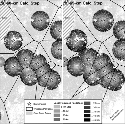
In our methods, each farm area was allowed to supply feedstock to only one biorefinery, even when there were multiple biorefineries within 80 km. In cases of overlapping LFSAs, we assigned farm areas to LFSAs using Thiessen polygons: that is, polygons drawn around each biorefinery such that all points within the polygon are closer to that biorefinery than to any other. After the analysis of an incremental 5-km ring, some biorefineries might have fulfilled their feedstock demand and no longer needed additional feedstock from rings farther away. When we conducted the analyses of those additional rings, we removed the fulfilled biorefineries and redrew the Thiessen polygons to reallocate feedstock-farm areas to their closest biorefinery. For these reasons, the sizes and shapes of the Thiessen polygons changed throughout the analysis of a given year. LFSAs for selected facilities bounded by Thiessen polygons are shown in , with the left panel showing data corresponding to the 40-km assessment stage and the right panel showing the subsequent 45-km assessment stage. Biorefineries plotted in the left panel were still acquiring local feedstock at the 40-km stage (and two biorefineries had their feedstock demand fulfilled prior to this stage, as indicated by supply rings shaded around unplotted biorefineries). The local-feedstock demand was fulfilled at the 40-km stage for three additional biorefineries, as indicated by the three biorefineries that were plotted in the left panel but not the right panel.
Figure 3. Example of Thiessen polygons and farm areas within 5-km supply rings at the 40-km calculation step (a) and the 45-km calculation step (b).
With this approach, the LFSA for a biorefinery consisted of all farm areas in each of the concentric 5-km rings surrounding the biorefinery (and closer to that biorefinery than any other biorefinery), until either the 80-km maximum distance was reached or at least 90% of the biorefinery’s feedstock demand was met, whichever comes first. When a biorefinery reached either of these two limits, we made no adjustments to the estimated amount of acquired feedstock; the estimated acquisition of local feedstock would either be less than 90% (i.e., local supply not acquired within 80 km) or somewhat more than 90% (i.e., we did not adjust the acquired amount downward to 90% if the calculation at the final 5-km ring “overshot” the goal of 90% local-supply acquisition).
Results and discussion
Description of the final database
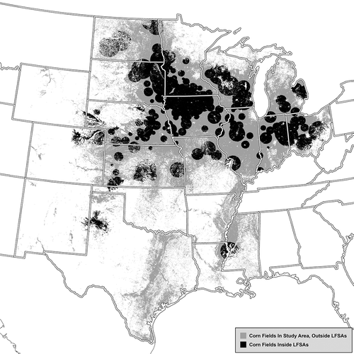
Using software and programming languages including ESRI ArcGIS, Microsoft Excel, and Python, we carried out the methods discussed in the “Project approach” section for each study year to produce the BFGD. The BFGD includes an ESRI file-based geodatabase for each year, each of which contains multiple ESRI ArcGIS Feature Datasets. These include estimates of crop and feedstock production at the scale of individual farm areas, including the total annual corn harvest (bushels per acre), and estimates of the quantity and percentage of the harvest utilized as bioethanol feedstock. The BFGD also includes the locations of the biorefineries, the shapes of the Thiessen polygons used to constrain the feedstock-supply areas around the biorefineries, the shapes of the 5-km incremental LFSA “rings,” and U.S. Geological Survey HUC-12 watershed areas. As an example of some of the data contained in the BFGD, includes the LFSAs of modeled ethanol biorefineries in 2009. The electronic supplement to this paper contains similar figures for the other 5 years in this study.
Figure 4. Local-feedstock-supply areas modeled in 2009 (darker shading) superimposed on all corn fields in the study area (lighter shading). Production data are not shown here but are included in the geospatial file used to create this plot.
Analysis results
We evaluated the BFGD by assessing how well the feedstock geospatial model matched locally sourced feedstock demand as estimated using the approach just described. As shown in , 2005 was the year when the largest percentage of biorefineries (98%) was able to procure enough feedstock to meet estimated demand. Most of the assessed biorefineries in 2005 were located in the heavy corn-farming areas of Nebraska, Iowa, Illinois, Wisconsin, and northern Missouri, where feedstock supply was highly abundant and feedstock demands were relatively modest. This allowed feedstock demands to be met by local supply using our methods. The median, per-biorefinery corn feedstock demand in 2005 was among the lowest in the assessment (16 million bushels, compared to more than 21 million bushels in 2007 and 2010; 2006, 2008, and 2009 were similar to 2005), and 2005 had the smallest percentage of overlapping LFSAs (96%, vs. as large as 99% in 2009).
Table 3. Procurement of the estimated, local, corn-feedstock demand for the assessed ethanol biorefineries.
Similar to 2005, our methods generally fulfilled estimated feedstock demand at biorefineries assessed in 2006–2009, when 88–92% of biorefineries procured enough feedstock to meet estimated demand in our assessment. There are many potential reasons why estimated feedstock demand went unfulfilled at a small percentage of biorefineries. As bioethanol production grew after 2005 (nearly tripling by 2009), the number of ethanol biorefineries in the study area grew quickly (more than tripling by 2009). Most of the new biorefineries in 2006–2010 were in heavy corn-farming areas of the Midwest and Great Plains, but the biorefineries tended to be closer together and the percentage of overlapping LFSAs grew by 2–3%, which might have caused unfulfilled feedstock demand at some biorefineries due to local feedstock competition. A relatively small number of added biorefineries were in areas with less corn farming (e.g., in Mississippi, northern Texas, and eastern Colorado and Wyoming), where corn production might not have been adequate to meet biorefinery feedstock demand.
In 2010, the percentage of biorefineries procuring enough feedstock to meet estimated local demand dropped to 74% in our estimations. National bioethanol production (and the total estimated feedstock demand of biorefineries in our assessment) grew by 23% from 2009 to 2010, while the number of assessed biorefineries decreased by 6%, causing the median per-biorefinery feedstock demand to reach a peak (within our study period) of 21.9 million bushels annual. USDA statistics indicate the acreage of corn planted nationally was greater in 2010 than in the prior two years, though national corn production was declining, suggesting that production per acre was also declining. The increase in per-biorefinery demand, coupled with the decrease in per-acre production, resulted in nearly a quarter of the biorefineries failing to meet our estimates of locally sourced corn feedstock demand in 2010.
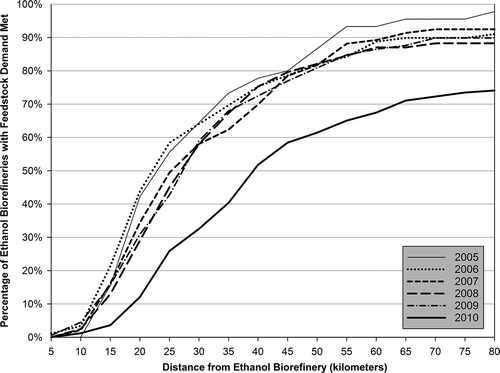
The general success of our methods for assessment years 2005–2009, as discussed earlier, can also be seen in , which shows overall how much local feedstock we estimate was procured as a function of farm-area distances from the biorefineries. Excluding 2010, the estimated feedstock demand of half of the biorefineries was fulfilled within roughly a 20- to 25-km radius of the biorefinery, and the estimated feedstock demand was fulfilled for approximately 90% of biorefineries within a 65- to 70-km distance. Noticeably fewer biorefineries met their estimated feedstock demand within 80 km in 2010 than in other years, as discussed earlier.
Figure 5. Cumulative percentage of ethanol biorefineries with 90% of feedstock demand met, by distance.
Measured in terms of how well LFSAs met the estimated biorefinery demand, our methods simulated a reasonably realistic pattern of feedstock supply. However, some limitations should be considered. Our calculations of biorefinery feedstock demand, crop yields of corn farms, and feedstock-procurement behavior were estimations based on available data, and no data were found to evaluate how well the methods estimated the actual geospatial distribution of the feedstock supply. We based the geospatial-estimation methods on reasonable assumptions (e.g., 80% feedstock allocation within 5 km of a biorefinery, and decreases in those percentages with increasing distance), but future work could test those assumptions. For example, model results could be compared using different percent-allocation patterns (e.g., 75 or 85% feedstock allocation within 5 km of a biorefinery) and incorporating other factors potentially affecting the estimated distribution of feedstock supply. For example, transportation and supply logistics are important factors, and we considered, and ultimately rejected, an alternative approach (not presented) to address them. In particular, we tested a road-distance approach at three biorefineries by simulating LFSAs based on the proximity to roadways of individual farm areas and the travel routes suppliers might take to reach biorefineries. The three facilities were ones where estimated feedstock demand was met when transportation supply networks were not considered. We chose two facilities with overlapping LFSAs and one facility with no overlap. We rejected the road-distance approach because the LFSAs it produced were similar in size and shape to LFSAs estimated with straight-line distances, yet the approach required considerably more computational resources to implement for the entire study area.
Transportation cost and logistics—which might be estimated by a more complex model, such as the Integrated Biomass Supply Analysis and Logistics (IBSAL) model (Sokhansanj, Citation2015)—also might affect a farmer’s decision on whether to supply a crop to a local biorefinery by roadway, to a distant biorefinery by train, or to some other endpoint such as a grain elevator. Including these factors in the methods would require data not readily available (e.g., the locations and operations of grain elevators) and many additional assumptions on farmer decision making. The geospatial distribution of bioethanol feedstock supply also might be affected by other factors excluded from our methods, including varying feedstock prices (including different prices offered by different biorefineries); varying feedstock quality; seasonal patterns of supply and demand; demand for crop harvests from competing industries; farming or fuel industry subsidies; farmer and biorefinery contractual agreements; varying bioethanol production processes; access to and capability of utilizing alternative feedstocks; and access to markets for refining by-products. Because of data limitations and uncertainties when trying to represent these other factors, we assumed a more complex approach would not necessarily be more defensible than the relatively simple approach chosen to develop the BFGD. Other aspects of biorefining might differ from year to year and location to location, including feedstock quality, refining efficiency, and the milling process, all of which affect the efficiency of converting feedstock to fuel.
Potential uses of the BFGD
This project was initiated because assessing the environmental impacts of bioethanol production requires geospatial data previously unavailable. The BFGD is now available from the authors to support such assessments for the study years covered, and the methods documented here may be applied to additional years, additional locations, and potentially other biofuels and feedstocks. The BFGD includes U.S. Geological Survey HUC-12 watersheds to use in evaluating potential surface-water impacts of feedstock production. Geospatial data could also be used to evaluate the relationship between bioethanol production and groundwater quality and availability, assess potential impacts on ecological services and sensitive habitats, and identify conservation priorities. Additionally, the BFGD could be used to study the relationship between bioethanol production and Conservation Reserve Program enrollments, and geospatial analyses of land-use conversions with changes in bioethanol-feedstock production could support more refined modeling of GHG emissions.
Summary
We have described the methods, data, and assumptions used to develop the BFGD—to our knowledge, the only farm-scale geodatabase of bioethanol-feedstock production information. The BFGD includes biorefinery locations, estimated crop- and feedstock-production amounts, and the estimated quantity and percentage of the harvest utilized as bioethanol feedstock. We developed the BFGD for each year 2005–2010 for areas in and around the U.S. Great Plains and Midwest regions where most of the national corn harvest and ethanol biorefineries are located. To estimate feedstock-farm locations, we assumed most of a biorefinery’s corn feedstock is grown within an 80-km radius, with supply utilizations being inversely related to distance from the biorefinery.
We evaluated the performance of the methods by assessing how well the feedstock geospatial model matched our estimates of locally sourced feedstock demand. The methods performed well in fulfilling the estimated feedstock demands—on average approximately 89% for the years studied. The only exception was 2010, in which 74% of biorefineries had their feedstock demand met according to our methods. These results suggest the majority of biorefineries could acquire all necessary corn feedstocks from within approximately 25 km of the biorefinery (except 40 km in 2010).
Future work could extend the BFGD to additional years and feedstocks or refine the methods to account for transportation logistics, market forces, competing crop and land uses, and other relevant factors. Future work could also utilize the BFGD in estimating the environmental footprint of bioethanol-feedstock production, including impacts on soil quality and erosion, carbon sequestration and GHG emissions, groundwater use, and water-quality concerns. These are the uses we envisioned when creating this database.
Disclaimer
The views expressed here are those of the authors and do not necessarily represent the views or policies of the U.S. Environmental Protection Agency.
Supplemental Figures
Download Zip (4.6 MB)Supplemental data
Supplemental data for this paper can be accessed at the publisher’s Web site.
Additional information
Notes on contributors
Christopher T. Holder
Christopher T. Holder (ICF International, Durham, NC) is a geospatial and environmental modeler.
Joshua C. Cleland
Joshua C. Cleland (ICF International, Saunderstown, RI) is a senior environmental quality analyst.
Stephen D. LeDuc
Stephen D. LeDuc (U.S. EPA, Arlington, VA) is a research scientist in EPA’s Office of Research and Development, National Center for Environmental Assessment.
Zac Andereck
Zac Andereck (previously ICF International, Rockville, MD; now FAS Analytics, Arlington, VA) is a geospatial analyst.
Chris Hogan
Chris Hogan (previously ICF International, Rockville, MD; now Fearless Solutions, LLC, Baltimore, MD) is a geospatial analyst.
Kristen M. Martin
Kristen M. Martin (previously ICF International, Fairfax, VA; now Montana Department of Environmental Quality, Helena, MT) is an environmental modeler and forecaster.
References
- Chiu, Y.-W., and M. Wu. 2012. Assessing county-level water footprints of different cellulosic- biofuel feedstock pathways. Environ. Sci. Technol. 46(16):9155–62. doi:10.1021/es3002162
- Ethanol Producer Magazine. 2011. U.S. ethanol plants. http://www.ethanolproducer.com/plants/listplants/US/Existing/All (accessed August 5, 2011).
- Fargione, J., J. Hill, D. Tilman, S. Polasky, and P. Hawthorne. 2008. Land clearing and the biofuel carbon debt. Science 319(5867):1235–38. doi:10.1126/science.1152747
- Gelfand, I., T. Zenone, P. Jasrotia, J. Chen, S.K. Hamilton, and G.P. Robertson. 2011. Carbon debt of Conservation Reserve Program (CRP) grasslands converted to bioenergy production. Proc. Natl. Acad. Sci. USA 106(33):13864–69. doi:10.1073/pnas.1017277108
- Hill, J., E. Nelson, D. Tilman, S. Polasky, and D. Tiffany. 2006. Environmental, economic, and energetic costs and benefits of biodiesel and ethanol biofuels. Proc. Natl. Acad. Sci. USA 103(30):11206–10. doi:10.1073/pnas.0604600103
- Mueller, S. 2010. Detailed report: 2008 National dry mill corn ethanol survey. University of Illinois at Chicago, College of Engineering, Chicago, IL.
- National Research Council of the National Academies. 2008. Water Implications of Biofuels Production in the United States; Committee on Water Implications of Biofuels Production in the United States. Washington, DC: National Academy Press.
- O’Hare, M., R.J. Plevin, J.I. Martin, A.D. Jones, A. Kendall, and E. Hopson. 2009. Proper accounting for time increases crop-based biofuels’ greenhouse gas deficit versus petroleum. Environ. Res. Lett. 4: 7pp. doi:10.1088/1748-9326/4/2/024001
- Plevin, R.J., and S. Mueller. 2008. The effect of CO2 regulations on the cost of corn ethanol production. Environ. Res. Lett. 3: 9pp. doi:10.1088/1748-9326/3/2/024003
- Rendleman, C.M., and H. Shapouri. 2007. New technologies in ethanol production. U.S. Department of Agriculture, Agricultural Economic Report Number 842. http://www.usda.gov/oce/reports/energy/aer842_ethanol.pdf.
- Renewable Fuels Association. 2015. Annual industry outlook. http://www.ethanolrfa.org/pages/annual-industry-outlook (accessed April 27, 2015).
- Searchinger, T., R. Heimlick, R.A. Houghton, F. Dong, A. Elobeid, J. Fabiosa, S. Tokgoz, D. Hayes, and Y.-H. Yu. 2008. Use of U.S. croplands for biofuels increases greenhouse gases through emissions from land-use change. Science 319:1238–40. doi:10.1126/science.1151861
- Sokhansanj, S. 2015. The Integrated Biomass Supply and Logistics Model (IBSAL). University of British Columbia Biomass and Bioenergy Research Group. http://biomass.ubc.ca/software/ (accessed May 12, 2015).
- U.S. Department of Agriculture. 2011. National Agricultural Statistics Service guide to crops/stocks survey. http://www.nass.usda.gov/Surveys/Guide_to_NASS_Surveys/Crops_Stocks/index.asp (accessed August 9, 2011).
- U.S. Department of Agriculture. 2011. USDA-NASS CropScape. http://nassgeodata.gmu.edu/CropScape/ (accessed August 9, 2011).
- U.S. Energy Information Administration, via U.S. Department of Agriculture. 2011. Alternative fuels data center maps and data, U.S. production, consumption, and trade of ethanol. http://www.afdc.energy.gov/data/categories/fuels-infrastructure ( accessed August 5, 2011).
- U.S. Environmental Protection Agency. 2011. Biofuels and the environment: First triennial report to Congress. EPA/600/R-10/183F. http://cfpub.epa.gov/ncea/biofuels/recordisplay.cfm?deid=235881.
- Wu, M., Y. Chiu, and Y. Demissie. 2012. Quantifying the regional water footprint of biofuel using multiple analytical tools. Water Resource Res. 48:W10518. doi:10.1029/2011WR011809
- Wu, M., Z. Zhang, and Y-W. Chiu. 2014. Life-cycle water quantity and water quality implications of biofuels. Curr. Sustain. Renew. Energy Rep. 1:3–10. doi10.1007/s40518-013-0001-2, e-ISSN 2196–3010.