
 ?Mathematical formulae have been encoded as MathML and are displayed in this HTML version using MathJax in order to improve their display. Uncheck the box to turn MathJax off. This feature requires Javascript. Click on a formula to zoom.
ABSTRACT
In the coming three decades, world waste will be expected to increase by 70%. Coupled with the absence of waste management technologies, unregulated dumping remained a threat to sustainable development in developing countries. To this end, this study emphasized to trace socially acceptable and environmentally friendly solid waste dumpsite for the northeastern arid cities of Ethiopia. The tuneful integration of GIS and MCDA was used for the end-to-end processing of 17 variables. At the earlier, to increase alternative dumpsites and seeking for safe zone outside the cities, 20 km buffer at Semera-logia city was used as a spatial scope of the study. Fifteen key informants (KIs) from related departments of the city and Samara University were selected to validate the model result. In the end, Ordinal Regression (OR) analysis was used to test the significance of the criteria’s on suitable dumpsite selection. The pair-wise comparison matrix shows that variables such as distance from surface water (11.32%), distance from the settlement (9.88%), distance from boreholes (8.87%), and aquifer productivity (8.51%) were the top weighed criteria for the study area. The weighted overlay result shows that 10.75% and 38.64% of the study area are found to be convenient and prohibited for dumping, respectively. Indeed, the KIs were agreed on 77% of the validation points and the agreement decreases from points of not-suitable to highly suitable. Except for aquifer productivity, all the 16 variables are significantly and negatively affect dumpsites suitability. This result can be further used as a preliminary database for experts to design landfill structures and also management operations for decision-makers.
Implications: The identification of potential dumpsite is an important step towards maximizing efficiency and building sustainability in the arid areas. The decision-making process shall be based on the empirical investigation. The decision-making process on dumpsite selection were well thought out both the socio-economic and environmental factors. In owing process, the empirical investigation that was conducted focusing on socio-economic dimension jeopardized other components of the environments. The approach that considers both socio-economic and spatial factors was all-inclusive. Overall, decision-makers could have a good insight to work on prioritizing dumpsite alternatives and implement feasible waste management actions.
Introduction
Background
Under the existing waste management scenario of the world, the waste disposal is expected to increase by 70% from 2.14 billion tonnes (2016) to 3.17 billion tonnes in 2050 (World Bank Citation2019) and it is a threat to sustainable development (Getahun et al. Citation2011). This implies that the impact of unsustainable waste management is worse in developing countries (World Bank Citation2019). The Sub-Saharan Africa region generated 174 million tons of waste in 2016 and more than 40% was organic (Kaza et al. Citation2018). Waste management is an essential urban service (Kaza et al. Citation2018). In Africa, less than half of the generated wastes are collected from door-to-door (Kassahun and Birara Citation2018) or informal points (Kaza et al. Citation2018).
Proper waste management is essential for building sustainable and livable cities, but it is a challenge for many developing countries and cities (Kassahun and Birara Citation2018; Umar and Naibbi Citation2019; World Bank Citation2019). Globally 33% of waste is still openly dumped (Kaza et al. Citation2018). In low-income countries, over 90% of waste is often disposed of in unregulated dumps or openly burned (World Bank Citation2019). Despite its location, waste dumping is the final hierarchy in the waste management process (Ekmekçioĝlu, Kaya, and Kahraman Citation2010). Around the world, almost 40% of waste is dumped to landfills (Kaza et al. Citation2018). However, proper landfilling is often lacking in developing countries (Hoornweg and Bhada-Tata Citation2012; Umar and Naibbi Citation2019). In this region, open dumping is prevalent and 93% of waste is burned or dumped on roads, open land, or waterways (Kaza et al. Citation2018). In developing countries like Ethiopia, the waste disposal system is unplanned and worsened (Kassahun and Birara Citation2018; Umar and Naibbi Citation2019). In cities like Mekelle, Bahir-Dar, Addis Ababa and Jimma, waste disposal areas are low-lying open spaces, roadsides and uncontrolled sanitary landfills (Adane and Muleta Citation2011; Getahun et al. Citation2011; Kassahun and Birara Citation2018; Regassa, Sundaraa, and Seboka Citation2011; Tadesse, Ruijs, and Hagos Citation2008). Besides, 74% of existing disposal sites are reported as unsuitable in Nigeria (Umar and Naibbi Citation2019).
The poorly managed solid waste operation causes different problems in different cities of developing countries (Regassa, Sundaraa, and Seboka Citation2011; World Bank Citation2019) Improper waste disposal causes health hazards, environmental contamination, climate change and urban violence (Mohammedshum et al. Citation2014; Munyai and Njabulo Citation2020; Regassa, Sundaraa, and Seboka Citation2011; Salinah, Naing, and Sarimah Citation2020; World Bank Citation2019). Effective waste management is expensive, which takes 20–50% of municipal budgets (World Bank Citation2019). However, landfilling is becoming more prevalent in the sub-Saharan Africa region (Kaza et al. Citation2018). Construction and use of landfills are commonly the first step toward sustainable waste management (Kaza et al. Citation2018).
Problem definition
Due to the rise in environmental awareness and education, investigating areas suitable for waste disposal is vital to the sustainable development of a city. Governments are pursuing sustainable waste disposal methods and looking for ways to expand local capacity and continuing effort to improve solid waste disposal practices (Kaza et al. Citation2018). The solid waste collection point ought to be convenient for the community (Yalew Citation2012) and needs careful planning (Regassa, Sundaraa, and Seboka Citation2011).
Proper solid waste management (SWM) requires convenient place for appropriate disposal (Kassahun and Birara Citation2018). Municipal solid waste (MSW) disposal is a complex and multidisciplinary problem that environmental, social, and technical as well as economic aspects need to be considered (Ekmekçioĝlu, Kaya, and Kahraman Citation2010). The convectional multi-criteria decision analysis (MCDA) techniques have largely been non-spatial and it lacks well-developed, analytical capabilities to support decision-making processes (Sharifi and Retsios Citation2004). The applications of geographic information systems (GIS) and remote sensing techniques are efficient and low cost in selecting the appropriate site of dumping (Mohammedshum et al. Citation2014).
The decision made by municipality officers on dumpsite selection needs, integrating the socioeconomic and environmental information. Waste disposal requires integrated systems that are efficient, sustainable, and socially supported (Fatoyinbo et al. Citation2020; Fernando and Claudio Citation2020; World Bank Citation2019). Site selection is a good application area for integrating the MCDA and GIS. Spatial-MCDA in a user-friendly environment is vital and enables us to arrive at an effective, most acceptable solution, efficient and policy-relevant information (Danesh et al. Citation2019; Ekmekçioĝlu, Kaya, and Kahraman Citation2010; Jensen and Christensen Citation1986; Muttiah, Engel, and Jones Citation1996; Sener Citation2004; Sharifi and Retsios Citation2004).
Related studies in Ethiopian cities confirmed improper SWM where (low-lying) open fields, roadsides, and uncontrolled sanitary landfills are common waste disposals and in further posing diseases and disturbing ecological integrities (Ali Citation2016; Ambaneh Citation2016; Asefa and Mindahun Citation2019; Beshir Citation2014; Erasu et al. Citation2018; Hailu, Hanchiso, and Bereta Citation2019; Kassahun and Birara Citation2018; Lohri, Camenzind, and Zurbrügg Citation2014; Mekuria, Muralitharan, and Ali Citation2019; Mohammed and Elias Citation2017; Mohammedshum et al. Citation2014; Mussa and Suryabhagavan Citation2019; Solomon Citation2018; Taddese and Balcha Citation2019; Tassie, Endalew, and Mulugeta Citation2019; Wakuma Citation2018; Wondim and Dzwairo Citation2018).
Despite the failure of execution, the FDRE constitution, Article 44.1 verbalized an environmental right as “All persons have the right to a clean and healthy environment” (FDRE Citation1994) and again environmental pollution control proclamation no. 300/2002 article 5.1 stated that “All urban administrations shall ensure the collection, transportation, and, as appropriate, the recycling, treatment or safe disposal of municipal waste through the institution of an integrated municipal waste management system” (FDRE Citation2002). Following that, specifically solid waste management proclamation no. 513/2007 was issued with the aim “to enhance at all level capacities to prevent the possible adverse impacts while creating economically and socially beneficial assets out of solid waste” (FDRE Citation2007). In detail, the responsible government body, Ministry of Urban Development and Construction, developed and set out a solid waste management manual (MUDC Citation2012). However, with different factors, comprehensive solid waste management in most cities of the country remains risky.
In an arid environment, glass containers, tin cans, plastic bags, and food-related solid wastes are most dominant. For instance, Dire Dawa and JigJiga city administrations devised solid waste dumpsites which are located 7 km far-away from the center of the city (MUDC Citation2016a, Citation2016b). However, in Dire Dawa, lack of administering the dumpsite causes a public health problem (MUDC Citation2016a). And also in JigJiga city, the dumpsite covers 4 ha and served for the past 13 years without a fence. Still, waste materials are dumped into the nearby Toga river and late military camp. Increasing the extent of the dumpsite and illegal burning of the waste are reported as a challenge in Jigjiga city (MUDC Citation2016b).
Around the study area, Samara-Logia city administration, massive amounts of solid wastes are dumped into river channels, drainage lines, sacred sites, and generally, free space out of the city are preferred areas (Ali Citation2016; Mussa and Suryabhagavan Citation2019). Mussa and Suryabhagavan (Citation2019) conveyed the dumpsite suitability map of Logia town using criteria such as road network, soil map, land use/land cover (LU/LC), slope, geology (permeability), river network, fault, built-ups, depth of wells. The study pointed highly suitable to suitable areas toward the northern part of Logia town that is near to Semera city. The major gaps of the study are (i) Semera and Logia are under one administration body which tend to grow each other and the middle space where the so-called highly suitable dumpsites would be part of the city, (ii) the decision criteria employed in the study are most common in humid areas. For instance, the wind direction is mostly blowing from north and northeast to Logia town (south) which carries waste materials back to the town. (iii) Urban expansion is a common event in an emerging area. This would have a significant impact on solid waste dumpsite suitability modeling. Hence, this indicates that dumpsite mapping must not be limited to the current boundary of a town rather considers future development options.
Therefore, important and contextually parameters suited to arid environments stretching from socioeconomic to ecological issues have to be experimented to locate sustainable solid waste dumpsites in the study area. The overall objective of this study is to locate urban solid waste dumpsite attaining ecological friendly, economically feasible, and socially acceptable via spatial-MCDA system contextualized for the arid city, Semera-logia.
Material and methods
Study area description
Semera-Logia town, the study area, is an administrative seat of Afar National Regional State of Ethiopia. Geographically, the study area is situated in 40.7°– 41.2°E longitude and 11.5°– 12.0° N latitude (). The Awash river is the most exploited river which crosses Semera-Logia and Dubti towns then flows to lake Abe at the lower plain (surface cease) of the basin (Yoseph, Bekele, and Mariam Citation2018a). The mean annual temperature at Dubti, Semera, and Logia site shows 30°c, 31°c, and 28°c, respectively, of which the hottest month ranges from May to September/October. The available mean annual precipitation record reveals near to 16 mm at all sites (Climate Data Citation2019; Yoseph, Bekele, and Mariam Citation2018a). From flat slope up to a gradient of 55° and hot desert climates type characterizes the study area.
Figure 1. Location map of the study area
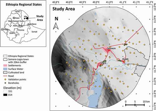
Out of the total population of Dubti district projected for 2017, 61.34% (61,521) of people are urban dwellers where Semera, Logia, and Dubti towns take a larger share (CSA Citation2013). Semera-Logia town is located on the grand import/export path of Ethiopia. The major economic sources of the town include trade, office work, and construction, and other small-to-large-business (Mussa and Suryabhagavan Citation2019). The major soil type includes Solonchaks, Leptosols, Regosols, and Fluvosols where the latter soil types are dominated by alluvial deposition and opportune for irrigated agriculture (FAO Citation2006). The study area accesses an annual river nearby and also pumps groundwater (GW) via boreholes and dug-wells (Yoseph, Bekele, and Mariam Citation2018a).
Data and data collection
Semera-Logia town is abandoned in terms of the massive solid waste disposals. Additionally, solid waste materials are dumped every day from individual homes, offices, shops, and other business centers (municipal waste). It is presumed that the future quantity of solid waste and disposal system is sought for systematic planning. Therefore, Semera-Logia town was purposively selected for comprehensive dumpsite selection. By assuming the future urban development and looking dumpsite out of the town, the current (2020) boundary of the towns were buffered with 20 km as a spatial scope.
All the required criteria considered for the acceptable solid waste dumpsite selection were collected from different sources, i.e., reports, books, articles, web pages, raw data providers, and field surveys (). According to current literature, in the first stage, 38 variables were identified and some variables were again merged and removed to suit the local context and finally 17 major socio-economic and environmental variables were selected for the study (). All data required for the study were collected and prepared in the late months of 2019. The spatial data pre-processing was undergone to harmonize the selected variables (data) in terms of projection (WGS 84/UTM zone 37 N) and resolution (30 m).
Table 1. MCDA parameters of solid waste disposal site selection
Data organization and analysis
Criteria preparation and suitability mapping
Following variable selection, in GIS environment, variables at which distance is measured were buffered with suitability class distance and again categorical variables, i.e., land use/land cover (LU/LC) and soil type were processed and then suitability class Id was assigned altogether to generate criteria suitability maps. Subsequently, the suitability class Id of the variables are used to convert into raster format to ease further analysis (; ; ).
Figure 2. Solid waste dumpsite selection modeling workflow
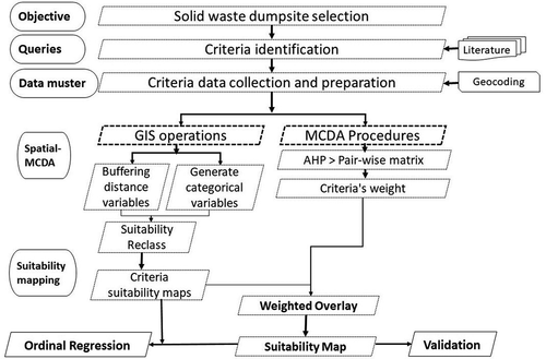
Figure 3. Variables suitability map
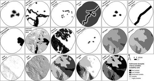
The landscape and land cover patterns of the study area are less heterogeneous. This helps the LU/LC mapping process in terms of techniques to be used. Therefore, the Google Earth satellite image of 2019 was imported to the QGIS interface and on-screen-digitizing technique was used to detect the LU/LC features of the study area. Finally, based on woody biomass inventory and strategic planning project definition (WBISPP Citation2004), eight LU/LC types such as bareland, grassland, shrubland, woodland, cultivated land (Cl), wetland (WL), waterbody (WB), and settlement (S) were identified.
The socioeconomic criteria include distance from the settlement, access to road (intermediate), distance from protected areas, distance from cultivated land, distance from electric towers, LU/LC, and distance from the rural residents. This criterion addresses community safety, health, and acceptance issues in the study area. Such as distance from residents (rural and urban) and protected areas (parks, religious places, airport, and institutions) protect stench; distance from road considers costs of transportation and safety of road adjacency; distance from electric tower protects power transmission towers from accidental damage incineration; LU/LC and distance from cultivated land safeguards the safety of productive lands ().
Environmental criteria are considered to protect potential contamination through waste leachate, pollution posing failure in ecological integrity, and ensure long-term stability of landfill structures. This criterion includes distance from surface water (pond, river, reservoir), distance from boreholes, aquifer productivity, soil type, lithology, slope aspect (facing to wind direction), soil depth, elevation (m), slope gradient (degree), distance from faults. The suitability ranking was stated to avoid potential costs of maintaining landfill structures and polluting soil and water resources ().
The Analytical Hierarchy Process (AHP) techniques of MCDA were used to evaluate the relative importance and weight of the variables. AHP is consists of three main operations, including hierarchy construction, priority analysis, and consistency verification (Saaty Citation2008).
In the first phase, the corresponding weight of all of the 17 variables was calculated using a pairwise comparison matrix. This is done using the relative importance of two variables considering one (equally important), two (moderately important), three (strongly important), four (very strongly important), and five (extremely important) () (Saaty Citation2008).
In the second phase, the consistency ratio (CR) (Equationeq.1)(1)
(1) and the consistency index (CI) (Equationeq.2)
(2)
(2) were calculated to verify pairwise assessment (Alonso and Lamata Citation2006; Saaty Citation2008). In calculating CI, the value of the random index (RI) value for 17 variables was obtained from Alonso and Lamata (Citation2006) which is equal to 1.6086. Finally, the calculated CI and CR values are 0.15 and 0.09, respectively. Therefore, the CR confirmed reasonable consistency of pairwise assessment (Saaty Citation2008).
Where λmax is maximum eigenvalues, n is number of parameters.
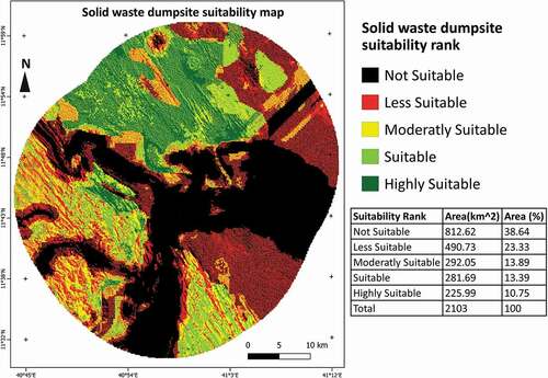
At the end of the workflow, the suitability values of each variable were prepared for overlay operation and multiplied by the corresponding weight of the variables to generate the final weighted overlay and suitability map ().
Validation
Different validation procedures are adapted to verify the certainty of spatial-MCDA results. Among that web-based public participation GIS was employed to select areas suitable for restaurant establishment. The study compared a map provided by the citizen and expert which revealed low-level of consistency (Vanolya, Jelokhani-niaraki, and Toomanian Citation2019).
In this study, a 30 km long and six transect lines with 5 km spacing were established. Afterward, random points were distributed along the transect lines and 96 representative points were taken () and the suitability level was sampled from the final suitability map. Finally, the sample points labeled by the suitability level were printed and provided for key informants to receive their dis/agreement on the expert-generated dumpsite suitability map.
Here, the key informants were selected based on their knowledge to interpret a map and understand the effects of improper waste dumping in the environment and community. Therefore, a total of fifteen (15) key informants from Semera, logia, and Dubti towns who are working in related departments and experts from Samara University were selected. Finally, a frequency table was used to summarize the responses.
Ordinal regression (OR) analysis
Depending on the nature of the endogenous variable which is the Likert or ordered variable, the ordinal regression, multinomial logistic regression, and binary logit (if the response variable is recoded into different variables i.e. dummy response) models can be used. If the dependent variable has a category which is a natural ordering, the ordinal regression model fits the data (Gujarati Citation2004; Rao Citation2008). To choose a link function, it is helpful to examine the distribution of values for the outcome variable (Elamir and Sadeq Citation2010).
Hence, to run the OR model, intersecting polygons of the 17 independent variables and the dependent variable (dumpsite suitability) maps were used and the spatially indexed category values were imported to statistical package for social science (SPSS v. 20). To identify the link function, the histogram of the dumpsite suitability data was observed and the “not suitable” category shows extreme values. For this type of dependent variable, Cauchit link function is typical fit this data (Elamir and Sadeq Citation2010; Wainaina Citation2012).
In the end, the Chi-square (X2) test, model goodness of fit, and significance of the predictor variables were generated and interpreted.
Results and conclusion
Dumpsites suitability modeling
In developing countries like Ethiopia, waste generation and improper dumping are increasing with population growth and urbanization. The waste generated is also dumped along the river, roadsides, and open areas. GIS and remote sensing techniques are tools that are employed in this kind of preliminary studies due to its ability to manage a large volume of spatial data from a variety of sources. Identifying suitable landfills using GIS may not be accepted by the local communities and decision-makers. The issue of selecting an optimal site for dumpsite is depended on the socio-spatial data. Therefore, the comprehensive approach that incorporates expert judgments (AHP-MCDA) and GIS is substantial. The study demonstrated the effectiveness of MCDA (i.e. AHP techniques) and GIS in the site identification and selection process.
Among the environmental and socio-economic criteria used in this study (; ), expert’s preference shows that, distance from surface water (11.32%), distance from the settlement (9.88%), distance from boreholes (8.87%), aquifer productivity (8.51%), distance to the road (6.75%) and distance from protected areas (6.75%) were given more weights and recognized as the most important criteria for landfill site selection ().
Recent studies revealed that, in addition to residential areas, environmental variables are considered and weighted larger than socioeconomic parameters (Asefa and Mindahun Citation2019; Danesh et al. Citation2019; Pasalari et al. Citation2019; Şener, Sener, and Karagüzel Citation2011). It is known that the quality and quantity of available water are limited in arid areas. This study has given more attention to water-related variables to protect sensitive resources of the area from solid waste contamination. In addition to that, wind blowing is a day-to-day phenomenon in arid areas. In this study, the slope aspect gets intermediate weight (4.49%). However, it is less weighted in studies such as Pasalari et al. (Citation2019).
Accordingly, the spatial-MCDA output map shows that 38.64% of the study area is found to not suitable for landfill or dumpsite. This contamination-free area is only for harmonious environmental integrity and citizens’ safety (). About 10.75% and 13.39% of the areas were highly suitable and suitable for the landfill/dumpsite, respectively. Related studies in the field reported that majority of modeled areas and existing waste disposal sites are not convenient in-terms of social safety, environmental cleanness, and economic feasibility (Asefa and Mindahun Citation2019; Fatoyinbo et al. Citation2020; Khodaparast, Rajabi, and Edalat Citation2018; Şener, Sener, and Karagüzel Citation2011). On the contrary, Erasu et al. (Citation2018) reported that 57.5% of solid waste is properly disposed of into landfill sites, whereas the remaining proportion of wastes are illegally dumped at roadsides and open spaces.
Figure 4. Solid waste dumpsite suitability map
In most cases, a higher number of parameters are considered as decision-making alternatives, the more reliable decisions could be made (Danesh et al. Citation2019; Pasalari et al. Citation2019). On the contrary, a fewer number of variables could reduce insight to indicate a precise location for dumping (Asefa and Mindahun Citation2019). Hence, this study considers multiple criteria and provides alternative sites for proper dumping of overwhelming solid wastes. Selection of specific location and design periods is left for experts working on the field and local decision-makers.
Validation
The response from the KIs revealed that 77% of the total points indicating the modeled dumpsite suitability level was acceptable (). In addition, the majority (51%) of the responses shows agreement on areas not suitable for dumping. Therefore, the consistencies of responses are higher on not suitable to less suitable areas for dumping.
Table 2. Summary of validation responses
According to the KIs response, model results for highly suitable and suitable areas were found extremely far from the center were subjected to disagreement. This shows that dumpsite should be placed neither near to the city, nor extremely distant areas.
Ordinal regression analysis
The significant X2 statistic indicates that the model gives a significant improvement over the baseline intercept only model (Appendix B). This tells us that the model gives better predictions than if we just guessed based on the marginal probabilities for the outcome categories.
Based on the model fitting information (i.e. X2 =150,797.4 and sig. = 0.000) can be concluded that there is an association between the dependent and independent variable(s) in cauchit link function.
The goodness of fit test table shows consistency between the observed data and the fitted model. Pearson’s X2 statistic for the model is intended to show whether the observed data are consistent with the fitted model. Since the significance values are small (sig. =0.000) the data and the model predictions are similar and observed data were consistent with the estimated values in the fitted model (Appendix B).
The Nagelkerke value indicates that about 94.8% of the variance in the outcome variable (dumpsite suitability) is explained by the predictor variables (Appendix B). The likelihood ratio X2 for testing the overall model (null hypothesis) is 19,894.299 with 186 degrees of freedom and a p-value of less than 0.0000. This tells us that the overall model fits better than we would expect by chance alone (Appendix B).
Appendix A summarizes the effect of each predictor variable. The sign of the coefficients of the independent variable gives important insights into the effects of the predictors/response variable in the model. The OR model shows that distance from borehole, distance from cultivated land, elevation, distance from the electric tower, distance from faults, lithology, LU/LC2019, distance from the protected area, distance from the road, distance from rural residents, distance from settlement/town, slope aspects, slope gradient/degree, soil depth, soil type and distance from surface water negatively and significantly affects the dumpsite suitability.
Therefore, the spatial-MCDA integrated approach can be concluded as practical in locating feasible and sustainable dumpsites and further used to be a preliminary database for experts to design landfill structures and also management operation for decision-makers.
Disclosure statement
No potential conflict of interest was reported by the authors.
Additional information
Notes on contributors
Teshome Betru Tadesse
Teshome Betru Tadesse has received his master of science (M.Sc.) degree in Watershed Management from Hawassa University, Ethiopia. He has authored and co-authored five articles. And currently, he is a lecturer and researcher at Samara University, Ethiopia.
Setiye Abebaw Tefera
Setiye Abebaw Tefera has received a master of art (MA) degree in Environment and Development from Addis Ababa University, Ethiopia. He has authored and co-authored three articles. And currently, he is a lecturer and researcher at Samara University, Ethiopia.
Mengist Tesfaye Kidane
Mengist Tesfaye Kidane has been working as an Assistant Lecturer in the Department of Civil Engineering, Samara University, Ethiopia. And currently, he is a lecturer and researcher at Samara University, Ethiopia.
References
- Adane, L., and D. Muleta. 2011. Survey on the usage of plastic bags, their disposal and adverse impacts on environment: A case study in Jimma City, Southwestern Ethiopia. J. Toxicol. Environ. Health 3 (8):234–48. doi:https://doi.org/10.1080/15287399309531713.
- Ali, A. M. 2016. GIS and remote sensing based suitable site selection for solid waste disposal: A case study of Asaita Town, Afar Regional State, Ethiopia. Ethiopia: Addis Ababa University.
- Alonso, J. A., and T. M. Lamata. 2006. Consistency in the analytic hierarchy process: A new approach. Int. J. Uncert. Fuzziness Knowledge-Based Syst. 14 (4):445–59. doi:https://doi.org/10.1142/S0218488506004114.
- Ambaneh, M. 2016. Solid waste disposal site selection using gis and remote sensing: From Mojo Town, Ethiopia. Ethiopia: Addis Ababa University.
- Asefa, B., and W. Mindahun. 2019. Suitable solid waste disposal site selection using geographical information system (GIS): A case of Debre Berhan Town, Ethiopia. Am. J. Environ. Prot. 7 (1):1–17. doi:https://doi.org/10.12691/env-7-1-4.
- Beshir, K. 2014. Suitable solid waste disposal site selection using GIS and remote sensing approach: A case of Welkite Town, Ethiopia. Ethiopia: Addis Ababa University. Addis Ababa University.
- Climate Data. 2019. Logia climate. Accessed December 30, 2019. https://en.climate-data.org/africa/ethiopia/afar/logiya-55038/
- CSA. 2013. Population projection of Ethiopia for all regions at wereda level from 2014 – 2017. Addis Ababa, Ethiopia: CSA (Central Statistical Agency).
- Danesh, G., S. M. Monavari, G. A. Omrani, A. Karbasi, and F. Farsad. 2019. Compilation of a model for hazardous waste disposal site selection using GIS-based multi-purpose decision-making models. Environ. Monit. Assess. 191 (2):122. Environmental Monitoring and Assessment: 1–14. doi:https://doi.org/10.1007/s10661-019-7243-4.
- Ekmekçioĝlu, M., T. Kaya, and C. Kahraman. 2010. Fuzzy multicriteria disposal method and site selection for municipal solid waste. Waste. Manag. 30 (8–9):1729–36. doi:https://doi.org/10.1016/j.wasman.2010.02.031.
- Elamir, E., and H. Sadeq. 2010. Ordinal regression to analyze employees’ attitudes towards the application of total quality management. J. Appl. Quant. Methods 5 (4):647–58.
- Erasu, D., T. Feye, A. Kiros, and A. Balew. 2018. Municipal solid waste generation and disposal in Robe Town, Ethiopia. J. Air Waste. Manage. Assoc. 68 (12):1391–97. Taylor & Francis. doi:https://doi.org/10.1080/10962247.2018.1467351.
- FAO. 2006. World Reference Base for Soil Resources - World Soil Resources Reports No. 103. Rome, Italy: FAO (Food and Agriculture Organization of the United Nations).
- Fatoyinbo, I. O., A. A. Bello, O. O. Olajire, O. E. Oluwaniyi, and O. F. Olabode. 2020. Municipal solid waste landfill site selection: A geotechnical and geoenvironmental‑based geospatial approach. Environ. Earth Sci. 79 (231):1–17. doi:https://doi.org/10.1007/s12665-020-08973-w.
- FDRE. 1994. Constitution of the federal democratic Republic of Ethiopia. Addis Ababa, Ethiopia: FDRE (Federal Democratic Republic of Ethiopia).
- FDRE. 2002. Environmental pollution control proclamation n. 300/2002. Addis Ababa, Ethiopia: FDRE (Federal Democratic Republic of Ethiopia), Federal Negarit Gazeta.
- FDRE. 2007. Solid waste management proclamation No. 531/2007. Addis Ababa, Ethiopia: FDRE (Federal Democratic Republic of Ethiopia), Federal Negarit Gazeta.
- Fernando, M. P., and A. V. Claudio. 2020. Considering environmental variables in the design of waste dumpsites. Environ. Sci. Pollut. Res. 27 (19):23769–82. doi:https://doi.org/10.1007/s11356-020-08657-9.
- Getahun, T., E. Mengistie, A. Haddis, F. Wasie, E. Alemayehu, D. Dadi, T. Van Gerven, and B. Van Der Bruggen. 2011. Municipal solid waste generation in growing Urban Areas in Africa: Current practices and relation to socioeconomic factors in Jimma, Ethiopia. Environ. Monit. Assess. 184 (10):6337–45. doi:https://doi.org/10.1007/s10661-011-2423-x.
- Gujarati, D. N. 2004. Basic econometrics. Fourth ed. New York: The McGraw−Hill Companies.
- Hailu, Y., T. Hanchiso, and A. Bereta. 2019. Municipal solid waste suitable disposal site selection, case study, Wolkite Town, Ethiopia. Int. J. Env. Sci. Nat. Res. 20 (4):126–31. doi:https://doi.org/10.19080/IJESNR.2019.20.556044.
- Hoornweg, D., and P. Bhada-Tata. 2012. What a waste: A global review of solid waste management. Washington, DC: Urban Development Series. 20433 USA. doi:https://doi.org/10.1201/9781315593173-4.
- Jensen, J. R., and E. J. Christensen. 1986. Solid and hazardous waste disposal site selection using digital geographic information system techniques. Sci. Total Environ. 56:265–76. doi:https://doi.org/10.1016/0048-9697(86)90331-1.
- Josimović, B., and I. Marić. 2012. Methodology for the regional landfill site selection. In Sustainable development-authoritative and leading edge content for environmental management, edited by Sime Curkovic, 513–38. London, UK: IntechOpen. doi:https://doi.org/10.5772/57353.
- Kassahun, T., and E. Birara. 2018. Assessment of solid waste management practices in Bahir Dar City, Ethiopia. Pollution 4 (2):251–61. doi:https://doi.org/10.22059/poll.2017.240774.311.
- Kaza, S., L. Yao, P. Bhada-Tata, and F. V. Woerden. 2018. What a waste 2.0: A Global snapshot of solid waste management to 2050. Washington, DC: Urban Development Series. Vol. 10. doi:https://doi.org/10.1596/978-1-4648-1329-0.
- Khodaparast, M., A. M. Rajabi, and A. Edalat. 2018. Municipal solid waste landfill siting by using GIS and analytical hierarchy process (AHP): A case study in Qom city, Iran. Environ. Earth Sci. 77 (2):52. doi:https://doi.org/10.1007/s12665-017-7215-3.
- Lohri, C. R., E. J. Camenzind, and C. Zurbrügg. 2014. Financial sustainability in municipal solid waste manage - costs and revenues in Bahir Dar, Ethiopia. Waste. Manag. 34 (2):542–52. Elsevier Ltd. doi:https://doi.org/10.1016/j.wasman.2013.10.014.
- Mekuria, T., J. Muralitharan, and Y. Ali. 2019. GIS and remote sensing based suitable site selection for solid waste disposal: A case study of Gondar Town, North West Ethiopia. J. Acad. Ind. Res. 8 (2):38–44.
- Mohammed, A., and E. Elias. 2017. Domestic solid waste management and its environmental impacts in Addis Ababa City. J. Environ. Waste. Manag. 4 (1):194–203.
- Mohammedshum, A. A., M. A. Gebresilassie, C. M. Rulinda, G. H. Kahsay, and M. S. Tesfay. 2014. Application of geographic information system and remote sensing in effective solid waste disposal sites selection in Wukro Town, Tigray, Ethiopia. Int. Arch. Photogramm. Remote Sens. Spat. Inf. Sci. XL–2:115–19. doi:https://doi.org/10.5194/isprsarchives-XL-2-115-2014.
- MUDC. 2012. Solid waste management manual: With respect to urban plans, sanitary landfill sites and solid waste management planning. Addis Ababa, Ethiopia: MUDC (Ministry of Urban Development and Construction).
- MUDC. 2016a. Dire Dawa City administration solid waste management and disposal (Amharic Version). Addis Ababa, Ethiopia: MUDC (Ministry of Urban Development and Construction).
- MUDC. 2016b. JigJiga city solid waste management and disposal indicative profile (Amharic Version). Addis Ababa, Ethiopia: MUDC (Ministry of Urban Development and Construction).
- Munyai, O., and W. Njabulo. 2020. Health effects associated with proximity to waste collection points in Beitbridge Municipality, Zimbabwe. Waste. Manag. 105:501–10. doi:https://doi.org/10.1016/j.wasman.2020.02.041.
- Mussa, A., and K .V., Suryabhagavan. 2019. Solid waste dumping site selection using GIS-based multi-criteria spatial modeling: a case study in Logia town, Afar region, Ethiopia. Geology, Ecology, and Landscapes. doi:https://doi.org/10.1080/24749508.2019
- Muttiah, R. S., B. A. Engel, and D. D. Jones. 1996. Waste disposal site selection using gis-based simulated annealing. Comput. Geosci. 22 (9):1013–17. doi:https://doi.org/10.1016/S0098-3004(96)00039-8.
- Pasalari, H., R. N. Nodehi, A. H. Mahvi, K. Yaghmaeian, and Z. Charrahi. 2019. Landfill site selection using a hybrid system of AHP-fuzzy in GIS environment: A case study in Shiraz City, Iran. Methods X 6:1454–66. Elsevier B.V. doi:https://doi.org/10.1016/j.mex.2019.06.009.
- Rao, C. R. 2008. Handbook of statistics volume 27:Epidemiology and medical statistics. Vol. 27. edited by J. P. Miller and D. C. Rao. Amsterdam, The Netherlands: North Holland.
- Regassa, N., R. D. Sundaraa, and B. B. Seboka. 2011. Challenges and opportunities in municipal solid waste management: The case of Addis Ababa City, Central Ethiopia. J. Hum. Ecol. 33 (3):179–90. doi:https://doi.org/10.1080/09709274.2011.11906358.
- Saaty, T. L. 2008. Decision making with the analytic hierarchy process. Int. J. Serv. Sci. 1 (1):83–98. doi:https://doi.org/10.1016/0305-0483(87)90016-8.
- Salinah, O., N. N. Naing, and A. Sarimah. 2020. Community health survey of residents living near a solid waste open Dumpsite in Sabak, Kelantan, Malaysia Bachok. Int. J. Environ. Res. Public Heal. 17 (311):1–14.
- Sener, B. 2004. Landfill site selection by using geographic information system. Turky: Middle East Technical University. http://biblioteca.usac.edu.gt/tesis/08/08_2469_C.pdf.
- Şener, Ş., E. Sener, and R. Karagüzel. 2011. Solid waste disposal site selection with GIS and AHP methodology: A case study in Senirkent-Uluborlu (Isparta) Basin, Turkey. Environ. Monit. Assess. 173 (1–4):533–54. doi:https://doi.org/10.1007/s10661-010-1403-x.
- Sharifi, M. A., and V. Retsios. 2004. Site selection for waste disposal through spatial multiple criteria decision analysis. J. Telecommun. Inf. Technol. 3:1–11.
- Simsek, C., C. Kincal, and O. Gunduz. 2006. A solid waste disposal site selection procedure based on groundwater vulnerability mapping. Environ. Geol. 49 (4):620–33. doi:https://doi.org/10.1007/s00254-005-0111-2.
- Solomon, S. 2018. Current solid waste management practices and problems in Woliata Sodo Town, Southern Ethiopia. J. Appl. Sci. Environ. Manag. 22 (7):1097–104.
- Taddese, S., and D. Balcha. 2019. Effects of urban waste disposal on water quality at open waste dumping sites effects of urban waste disposal on water quality at open waste dumping sites of Asella City, Arsi Zone, Southeast Ethiopia. Int. J. Curr. Res. 11 (9):6761–66. doi:https://doi.org/10.24941/ijcr.35441.09.2019.
- Tadesse, T., A. Ruijs, and F. Hagos. 2008. Household waste disposal in Mekelle City, Northern Ethiopia. Waste. Manag. 28 (10):2003–12. doi:https://doi.org/10.1016/j.wasman.2007.08.015.
- Tassie, K., B. Endalew, and A. Mulugeta. 2019. Composition, generation and management method of municipal solid waste in Addis Ababa City, Central Ethiopia: A Review. Asian J. Environ. Ecol. 9 (2):1–19. doi:https://doi.org/10.9734/ajee/2019/v9i230088.
- Umar, U. M., and A. I. Naibbi. 2019. Analysis and suitability modeling of solid waste disposal sites in Kano Metropolis, Nigeria. Geocarto Int. 1–25. doi:https://doi.org/10.1080/10106049.2019.1655796.
- Vanolya, N. M., M. Jelokhani-niaraki, and A. Toomanian. 2019. Validation of spatial multicriteria decision analysis results using public participation GIS. Appl. Geogr. 105:25–36. Elsevier Ltd. doi:https://doi.org/10.1016/j.apgeog.2019.102061.
- Wainaina, N. P. 2012. Modeling Job satisfaction among call center agents: Ordinal regression model. Ethiopia: Addis Ababa University.
- Wakuma, K. A. 2018. Waste electrical and electronic equipment management in the educational institutions and governmental sector offices of Addis Ababa. Ethiopia: Addis Ababa University.
- WBISPP. 2004. Woody biomass inventory and strategic planning project - phase 2. Addis Ababa, Ethiopia: WBISPP.
- Wondim, T. T., and B. Dzwairo. 2018. A scenario-based multiple attribute decision-making approach for site selection of a wastewater treatment plant: Bahir Dar City (Ethiopia) Case Study. Water SA 44 (4):782–94. doi:https://doi.org/10.4314/wsa.v44i4.26.
- World Bank. 2019. Solid waste management. World Bank. Accessed November 28, 2019. https://www.worldbank.org/en/topic/urbandevelopment/brief/solid-waste-management
- Yalew, A. 2012. Do institutional factors matter for improved solid waste management? Munich. Pers. RecPEc Arch.Paper No. 42894. mpra.ub.uni-muenchen.de/42894
- Yoseph, Z., N. Bekele, and M. K. Mariam. 2018a. Hydrogeological and hydrochemical maps of serdo NC 37 – 4 sheet: Explanatory notes. Addis Ababa, Ethiopia: Geological Survey of Ethiopia.
- Yoseph, Z., N. Bekele, and M. K. Mariam. 2018b. Hydrogeological Map of Serdo NC 37-4 and Djibouti NC 38-1. Addis Ababa, Ethiopia: Geological Survey of Ethiopia.
Appendix
Appendix A. Association of variables with dumpsite suitability on the ordinal regression model
Appendix
Appendix B. Model parameters information and fitness tests