
 ?Mathematical formulae have been encoded as MathML and are displayed in this HTML version using MathJax in order to improve their display. Uncheck the box to turn MathJax off. This feature requires Javascript. Click on a formula to zoom.
ABSTRACT
Fast population growth and urbanization has increased the generation of municipal solid waste in Oman. Currently, Oman relies on landfills to handle growing amounts of waste, which has burdened the existing solid waste management infrastructure. This situation calls for establishing incineration plants that can considerably reduce the volume of waste, and can simultaneously produce electricity. However, one of the crucial steps in the planning of an incineration plant is the selection of an appropriate site that can overcome environmental and economic implications and eliminate community dissatisfaction. Therefore, to select an optimal site for incineration plant in Muscat and South Batinah governorates, where landfills receive the highest waste amounts per day, this research identified 11 criteria that cover the environmental, economic, and social concerns. These criteria were processed by combining the multicriteria decision making (MCDM) method and geographical information system (GIS) software where the suitability of individual criteria were evaluated and then integrated using the weighted overlay analysis to generate a final suitability map for incineration site selection. The final suitability map indicated that only 2% of the land is suitable for setting up an incineration plant in the study area, and the most suitable location with adequate area was found in Barka wilaya of South Batinah governorate.
Implications: Due to the escalation in MSW generation, Oman is looking for alternative strategies to reduce the volume of MSW. This has led to country’s interest in establishing a waste-to-energy plant (particularly incineration) in the future. However, locating a suitable site for the installation of an MSW incineration plant in Oman has never been studied before. Therefore, to bridge the gap in knowledge, this research focuses on selecting a suitable site for a municipal solid waste incineration plant using GIS and multicriteria decision analysis. This study highlights the suitability of Muscat and North Batinah governorates of Oman where landfills receive huge amounts of MSW on a daily basis and are close to becoming saturated. Moreover, the suitability of land in both governorates is assessed to overcome environmental and economic implications and eliminate community dissatisfaction. This research not only provides the level of suitability of land in both governorates, but also selects a suitable site, which will be beneficial for the government of Oman in future when making a decision regarding the location of the plant.
Introduction
In recent years, the massive increase in the generation of municipal solid waste (MSW) has been attributed to accelerated growth in the world’s population combined with high economic and industrial development (Rajaeifara et al. Citation2017). Municipal solid waste is responsible for the degradation of the environment in urban and rural areas of developing countries, which mostly or entirely rely on waste disposal (Abdallah et al. Citation2018; Feyzi et al. Citation2019). Integrated MSW management strategies, based on energy and material recovery from waste, have been implemented around the globe to reduce the disposal of waste in landfills; such strategies follow the waste management hierarchy, which recommends the reduction in waste, followed by reuse, recycle, energy recovery, treatment, and disposal at the end (EPA Citation2018). Moreover, in recent years, a shift from the practice of landfilling to incineration has been observed in many Asian, European, and American countries (Feyzi et al. Citation2019).
The ability of incineration process to reduce the volume and weight of MSW, and to simultaneously generate energy makes it an attractive option as opposed to landfill disposal (Nabavi-Pelesaraei et al. Citation2017). The reduction in volume of MSW by establishing an incineration plant relieves the cost associated with the disposal of waste (Hassaan Citation2015), mainly because the incineration plant requires less area than landfill (Nabavi-Pelesaraei et al. Citation2017). However, site selection of an MSW incineration plant is a crucial step that should consider important economic, environmental, technical and social criteria (Wu et al. Citation2018). The decision-making process involved in the site selection of the incineration plant follows the common goal of measuring desirability in terms of economic, environmental, and social aspects (Panepinto and Zanetti Citation2018); but, the underlying criteria vary from country to country or even from state to state (Feyzi et al. Citation2019). In a number of studies conducted on the selection of incineration plant site, authors used criteria particular to the area under consideration. For instance, in a study by Feyzi et al. (Citation2019), environmental criteria (elevation, slope, distance from rivers, ground water depth, distance from faults, soil texture, geology), economic criteria (distance from protected areas, land use, distance from roads, distance from railways, distance from electricity grid, distance from landfills) and social-cultural criteria (distance from tourist attraction, distance from urban center), and in a study by Hassaan (Citation2015), distance to landfill and transfer stations, distance to main roads, distance to electricity grid, distance to sensitive land uses, existence of vacant or derelict land have been used as criteria for the site selection of the MSW incineration plant. Ferretti and Pomarico (Citation2012) considered almost similar criteria with the addition of water quality index, flood areas, distance to dangerous industries, index of naturalness, population density, residential real estate, and distance to human settlement. Whereas, Tavares, Zsigraiová, and Semiao (Citation2011) used two scales for locating an incineration plant site, i.e. global (waste transportation cost, distance from electricity grid, distance from coast line, fly ash transportation cost, portable water demand, land orientation, land cover) and local (distance from road network, distance from coastline terrain slope, terrain elevation, distance from urban centers, land-use type, air pollution, and visibility impact) scale.
Decision-making in the solid waste management sector involves several criteria that increases the complexity of the process. Therefore, project planners usually rank them to prioritize the criteria (Zavadskas, Baušys, and Lazauskas Citation2015). The multicriteria decision-making (MCDM) method can deal with huge amounts of complex data to supply a consistent assessment of potential sites based on several environmental, economic, and social factors (Tavares, Zsigraiová, and Semiao Citation2011). The MCDM technique helps to solve complex issues that are difficult for human decision-makers to handle in a consistent way. This happens due to large amount of information and involvement of multiple criteria in the decision-making or ranking process. Normally, an optimal solution is not reached just based on the MCDM method, therefore, decision-makers preferences are necessary to differentiate between solutions (Qazi and Abushammala Citation2020). The MCDM methods are often implemented with geographic information system (GIS) environment for solid waste site selection as both methods possess unique abilities that complement each other (Kabak & Keskin, 2018). The integration of MCDM and GIS offers a powerful technique that facilitate any siting process and offers efficient way of managing solid waste system (Tavares, Zsigraiová, and Semiao Citation2011). The use of the MCDM-GIS technique has been widely used for siting solid waste treatment facilities, however, the majority of studies focused on siting landfills (Al-Jarrah and Abu-Qdais Citation2006; Alkaradaghi et al. Citation2019; Chabuk et al. Citation2019; Chang, Parvathinathan, and Breeden Citation2008; Cheng and Thompson Citation2016; Eskandari, Homaee, and Mahmodi Citation2012; Hereher, Al-Awadhi, and Mansour Citation2020; Şener, Sener, and Karagüzel Citation2011; Sisay, Gebre, and Getahun Citation2020); while, a couple of studies also used similar technique to select suitable sites for MSW incineration plant (Ferretti and Pomarico Citation2012; Feyzi et al. Citation2019; Hassaan Citation2015; Tavares, Zsigraiová, and Semiao Citation2011).
The MSW management system in Oman solely depends on landfilling, which results in huge amounts of greenhouse gas (GHG) emissions. In addition, due to the escalation in MSW generation the country is looking for alternative strategies to reduce the volume of MSW. An incineration plant for MSW treatment presents an effective solution for Oman to address its waste management challenges and meet energy demands, simultaneously providing an opportunity to make the waste sector profitable. However, locating a suitable site for the installation of an MSW incineration plant in Oman has never been studied before. Therefore, this research focuses on developing criteria considering economic, environmental, and social factors in order to create a model using MCDM and GIS, which will assess the suitability of areas in South Batinah and Muscat governorates in Oman for the installation of an MSW incineration plant.
Materials and methods
Study area
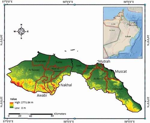
Oman is situated in the Southeast corner of Arabian Peninsula between 23° 60’ N and 58° 55’ E with an elevation ranging from 0–2771.84 m. As per by the 2021 statistics, the total population of Oman is 5.1 million (World Bank Citation2022). Oman has 11 governorates and most of the population lives in the northern governorates of Muscat and Al Batinah (subdivided into North and South Batinah) (NCSI, Citation2021a). Muscat and South Batinah shares a border and collectively occupies area of 9120 km2 between 22° 53’ and 23° 47’ N and 57° and 59° 13’ E (). In these areas winds mainly blow from the northeast and are usually slow (Hereher, Al-Awadhi, and Mansour Citation2020). Oman has a dry climate with daily mean average temperature of 21°C in January and 35°C in July, and precipitation does not surpass 200 mm/year except in the southern region of the country. (Hereher, Al-Awadhi, and Mansour Citation2020). Both Muscat and South Batinah are subdivided into six administrative units, known as wilaya or district (i.e., Ar Rustaq, Al Awabi, Nakhal, Wadi Al Maawil, Barka, and Al Musanaah in South Batinah, and As Seeb, Bawshar, Mutrah, Al Amrat, and Qurayyat in Muscat) (NCSI, Citation2021b).
Figure 1. Location of South Batinah and Muscat Governorate with districts. (Red lines show the boundary of wilaya/districts in the governorates of South Batinah and Muscat).
Solid waste generation
As per the recent population data, the total population of the two governorates is 1.789 million (40% of the total population), out of which 1.329 million reside in Muscat (NCSI, Citation2021a). As Muscat is the economic and political center with main government offices, dense road network and international airport, it has the highest daily waste generation (2,016 tonnes/day) than rest of the governorates; whereas, South Batinah generates 497 tonnes of waste daily (Oman Environmental Services Holding Company (be’ah) Citation2019). Almost all governorates have their own engineered landfills, but the highest average daily waste of 1772 tonnes is received at Barka landfill in South Batinah, and second highest (985 tonnes) at Al Multaqa landfill in Muscat. Despite higher daily waste production in Muscat, the average daily waste received at the Barka landfill (South Batinah) is almost double the waste disposed at Al-Multaqa landfill in Muscat. This is mainly because the waste of As Seeb and Bawshar districts in Muscat is disposed in Barka landfill (Al-Dughaishi AS, be’ah, personal communication, November 16, 2020). The high amounts of solid waste are a significant concern for pollution and environmental deterioration, therefore, minimizing waste is paramount. The higher waste amounts in these two governorates makes them an optimum place to set up a waste-to-energy incineration plant, which will offer a way to reduce volume and disposal of waste.
Determining siting factors
The process of site selection for the incineration plant should consider a wide range of related criteria to ensure that the selected site has the lowest impact on the surrounding environment and natural resources, and has the lowest possible economic cost (Feyzi et al. Citation2019; Hassaan Citation2015). However, such criteria vary from country to country and region to region (Tavares, Zsigraiová, and Semiao Citation2011). Therefore, prior to establishing an incineration plant, a region-specific study is needed to determine the most suitable site. Currently, Oman does not have legal and codified guidelines for the selection of an incineration plant site and, therefore, based on the conditions of the study area, thorough literature review and consultation with 15 experts from Ministry of Housing and Urban Planning in Oman, be’ah, Oman Electricity Transmission Company S.A.O.C, industry and academia, 11 relevant criteria were identified in this study for the selection of an incineration plant site in Muscat and South Batinah. The description of selected criteria is presented below
Distance to sensitive land uses
Operation of incineration plant results in noise, odor and emissions that cannot be avoided. Emissions from the plant are harmful to human health and for that reason plant site should be situated away from inhabited zones and tourist attractions (Hu et al. Citation2015; Tavares, Zsigraiová, and Semiao Citation2011; World Bank Citation2000). This means that the longer the distance between sensitive land uses (residential, health and educational services, tourist attractions, commercial, mosques, etc.) and incineration plant site the better it is in mitigating adverse impact of nuisance factors. The areas and plots reserved for future development are also considered when finding suitable sites for the plant.
Distance to protected areas
It is important to select a site with adequate distance from nature reserves, flora and fauna, sensitive ecosystems like wetland, etc. to avoid any impact on the habitats of valuable and rare species, plant and animal communities (Feyzi et al. Citation2019).
Distance from agricultural land
To avoid the deposition of pollutants on edible crops and vegetation, the incineration plant site should be located away from the agricultural land. The suitability of the area increases as the distance between plant site and agricultural land increases.
Distance from wadis/valleys
Plants are ideally not located in areas that are liable to flooding to ensure smooth supply of waste (WRAP, Citation2012). Therefore, sufficient distance should be maintained from wadis/valleys to avoid disruption of waste transportation during rainy seasons when wadis can easily overflow (be’ah, personal communication, December 22, 2020).
Distance to surface water
Distance from surface water should be kept maximum to reduce the impact of eutrophication (be’ah, personal communication, December 22, 2020).
Distance to landfills
The transportation of solid waste is a vital element of integrated solid waste management system that has its own environmental and economic problems like pollution and fuel consumption (Tavares, Zsigraiová, and Semiao Citation2011). Solid waste transportation is responsible for a huge portion of operational cost of incineration plant, which directly affects the feasibility of the plant. It is important to minimize the cost of transportation by selecting a plant site relatively closer to the potential solid waste source (World Bank, Citation2000; Hu et al. Citation2015; (WRAP, Citation2012). Therefore, it is preferable to build a plant close to landfills that receive huge amounts of solid waste on daily basis to minimize the transportation cost and pollution (be’ah, personal communication, December 22, 2020).
Distance to electricity grid
To minimize operational and construction costs and ensure proper use of produced electricity, the incineration plant should be located close to the existing electricity grid in order to easily supply the generated electricity to the grid (Hassaan Citation2015; Tavares, Zsigraiová, and Semiao Citation2011).
Distance to road network
It is preferable to select a plant site closer to main roads to ensure easy access and smooth transportation of waste to the plant (Feyzi et al. Citation2019; Hassaan Citation2015; Tavares, Zsigraiová, and Semiao Citation2011). This will eliminate the cost of constructing roads specifically for the plant (be’ah, personal communication, December 22, 2020).
Elevation
As far as elevation of the area is concerned, higher elevation has a direct impact on the fuel economy of the trucks transporting solid waste to the plant site (be’ah, personal communication, December 22, 2020). Therefore, site should be located in an area with lower elevation.
Terrain slope
Flatter areas are more suitable for the construction of an incineration plant as technical feasibility of an area for building industrial facility reduces with the increase in slope (Feyzi et al. Citation2019; Tavares, Zsigraiová, and Semiao Citation2011).
Distance from airport
Typically waste-to-energy plant has chimney heights of 30–40 m, hence adequate distance from airport site should be maintained to avoid any inconvenience (be’ah, personal communication, December 22, 2020). As per Ministry of Environment and Climate Affairs (MECA) Ministerial Decision No. 17/93, a buffer zone of 7 km is necessary for landfill sites and same is used for the incineration plant in this study.
Land availability
To construct an incineration plant on undeveloped or derelict land should be available in the study area. The plots and areas reserved for future development along with the currently occupied land was restricted to find the available land. This criterion is not ranked as the purpose was to identify undeveloped/available land to conduct analysis.
Moreover, after a detailed literature review and consultation with experts, criteria were identified which are presented on the grading scale of 0 to 10 in (Hereher, Al-Awadhi, and Mansour Citation2020; Tavares, Zsigraiová, and Semiao Citation2011); where 0 is the restricted area (excluded from examination), 1 is the least preferable, and 10 is the most preferable area (Hereher, Al-Awadhi, and Mansour Citation2020; Tavares, Zsigraiová, and Semiao Citation2011). This scale is used in ArcGIS software 10.8.1 to analyze low, medium, highly suitable areas in each criterion, before they are integrated with all other criteria based on the MCDM method. The suitability degrees and buffer zones identified for criteria () were used to reclassify (0–10) the slope and elevation maps, and euclidean distance raster surfaces generated for other criteria (Hereher, Al-Awadhi, and Mansour Citation2020; Tavares, Zsigraiová, and Semiao Citation2011). The reclassification of all criteria layers indicated the restricted and least to highly suitable areas for individual criterion.
Table 1. Description and grading values of final criteria.
Data preparation, euclidean distance and reclassification
The analysis in this study relied on data acquired from several sources. The digital land use maps prepared by the NCSI in Oman were used to obtain data for protected areas, road network, airport, wadi/valleys, surface water, and agricultural land (NCSI, Citation2021b). The elevation contour lines (20 m intervals) was also provided by the NCSI, which was used in ArcMap 10.8.1 to create a digital elevation model (DEM). The slope in degrees was extracted from the DEM with the interval of 2.5° The data relating to land reserved for future development and existing buildings (residential, commercial, tourism, industrial, etc.) was provided by the Ministry of Housing and Urban Planning. The location and data of landfills was provided by be’ah, whereas Oman Electricity Transmission Company S.A.O.C provided electricity transmission lines and grid data for the study area. The entire dataset was in the form of vector layers, except the derived DEM and slope maps that were in the form of raster layers.
Initially, all spatial data layers were projected to the coordinate system of World Geodatic System (WGS) 1984, Universal Transverse Mercator (UTM) Zone 40 N. Thereafter, a euclidean distance tool was used in ArcMap 10.8.1 to generate raster surfaces for criteria that represented radial distance from the feature under consideration (protected areas, sensitive areas, wadi/valleys, road network, etc.) within the boundaries of Muscat and South Batinah. The suitability degrees and buffer zones identified for criteria () were used to reclassify (0–10) the slope and elevation maps, and euclidean distance raster surfaces generated for other criteria (Hereher, Al-Awadhi, and Mansour Citation2020; Tavares, Zsigraiová, and Semiao Citation2011). The reclassification of all criteria layers indicated the restricted and least to highly suitable areas for individual criterion. presents the data collected and source for all criteria.
Table 2. Data requirement for each criterion.
Weighted overlay
The use of MCDM method in combination with ArcGIS 10.8.1 can extract valuable information by exploiting nonspatial and spatial datasets, which can assist in decision making based on the expert judgments (Kamdar et al. Citation2019). The MCDM method is employed to calculate weights of criteria under consideration based on the judgments of experts, which are then aggregated with the help of weighted overlay. In this technique the output of the MCDM method (different weights of criteria) and multiple reclassified data layers are combined in ArcGIS software 10.8.1 using a weighted overlay tool (Aderoju, Dias, and Gonçalves Citation2018). This method has been widely used for siting waste management facilities in ArcGIS 10.8.1 environment (Tavares, Zsigraiová, and Semiao Citation2011; Ferretti and Pomarico Citation2012; Hassaan Citation2015; Motlagh and Sayadi, Citation2015; Pasalari et al. Citation2019; Feyzi et al., Citation2019).
Therefore, to meet the objective of selecting a suitable site for the incineration plant in Muscat and South Batinah governorates, criteria were ranked by the expert advisory system based on their importance to the Omani environment and environmental regulations. The expert advisory system involved same experts that were consulted for finalizing criteria. This study involved 11 criteria, and the rank of 11 represented the highest influence on the selection of plant site and 1 depicted lowest impact. Based on the ranks, relative weights of all criteria were computed using EquationEq. 1(1)
(1) (Malczewski Citation1999):
Where, wv is relative weight of criteria, Vs indicates criteria rank and Tr is is the total rank value obtained from the sum of all ranks. Thereafter, weighted overlay function in ArcMap 10.8.1 was used to overlay the criteria layers (after reclassification) with different weights to generate a composite map for the suitability categories across the study area. EquationEquation 2(2)
(2) was used to compute the total suitability by adding the weights of criteria (Kamdar et al. Citation2019):
Where, SI is the suitability index of the area, wi is the weight of the criterion i and si is the standardized suitability score of criterion i. The suitability scale for the final map was grouped into three classes, i.e. low, moderate and high (Hereher, Al-Awadhi, and Mansour Citation2020). This method allowed the integration of the data layers of criteria to identify suitable sites for incineration plant in Muscat and South Batinah.
Site selection
The availability of derelict land is vital to construct incineration plant, therefore, in the process of selecting suitable site this study applied the exclusionary factor of land availability to exclude areas that are already occupied or are reserved for future development. For this purpose, the raster surface generated in the previous step of weighted overlay was masked by the derelict land layer. The resulting raster surface displayed suitable areas that are free and available for the construction of plant in future.
Results and discussion
This is the first study to identify suitable sites for incineration plant in South Batinah and Muscat governorates of Oman. Overall, based on the guidelines presented in relevant literature and opinion of regional experts, 11 criteria were finalized that covered the environmental and socioeconomic aspects of establishing incineration plant in Oman. This study adopted the popular method of using MCDM technique in ArcGIS Software 10.8.1 for decision making.
Relative weights of criteria
Regional experts assigned ranks to each criterion, which were used to compute relative weights (). Results show that maintaining adequate distance between incineration plant and sensitive land uses/inhibited land is of prime importance (16.67%). This factor is very important for siting an incineration plant to avoid nuisance factors such as noise, emissions, and odors and protect public health. The criterion of distance from landfill has the second highest influence (15.15%) on the selection of incineration plant site in Oman, followed by distance to road network (13.64%), distance to wadi/valleys (12.12%), elevation (10.61%) and distance to electricity grid (9.09%). These criteria have direct impact on the operation and construction cost, site accessibility and supply of waste to the plant. To ensure proper and efficient operation of the incineration plant, huge amounts of solid waste needs to be delivered to the site on daily basis. Therefore, the minimum distance to waste source, accessibility and undisrupted waste supply to the plant site is crucial. Similarly, the presence of infrastructure to deliver the produced electricity to the national electricity grid is vital, as higher distance of plant site from the electricity grid network can increase the construction cost and electricity losses. The relative weights of distance from agricultural land (7.58%), protected areas (6.06%) and surface water (4.55%) reflects intermediate importance, while distance from airport (3.03%) and terrain slope (1.52%) has the lowest impact on the selection of plant site. Example of calculations is given below:
Table 3. Relative weights of criteria.
Weight of distance to sensitive land uses () =
%
Suitability analysis of individual criteria
The results from the classification (0–10) of each criterion in ArcGIS 10.8.1 are displayed in (Hereher, Al-Awadhi, and Mansour Citation2020; Tavares, Zsigraiová, and Semiao Citation2011). The study area has a dense road network, with higher ease of accessibility in northern area (near the shoreline) where most of the population is situated. The road network is spread across the entire South Batinah governorate, however, accessibility decreases in the south-east direction of Muscat where only one main highway connects the farthest district of Qurayyat with Al Amrat and rest of the districts. In contrast, almost the entire Muscat governorate is moderately to highly suitable in terms of access to the electricity grid network, while only northern and central parts of the South Batinah falls under that category. However, it is observed that a massive proportion of the moderately to highly suitable areas in terms of distance to road network and electricity grid is restricted by agricultural land, sensitive land use and their future development. Due to the government’s development plans, several sites are allocated for industrial activities, urban expansion, agriculture and tourism in the study area. The rapid urban expansion of South Batinah and Muscat is attributed to the fact that these governorates accommodate 40% of the country’s population.
Figure 2. Suitability ranking of individual criteria, i.e., red (0) is restricted area, 1–4 represents low suitability, 5–7 represents moderate suitability, and 8–9 is highly suitable area.
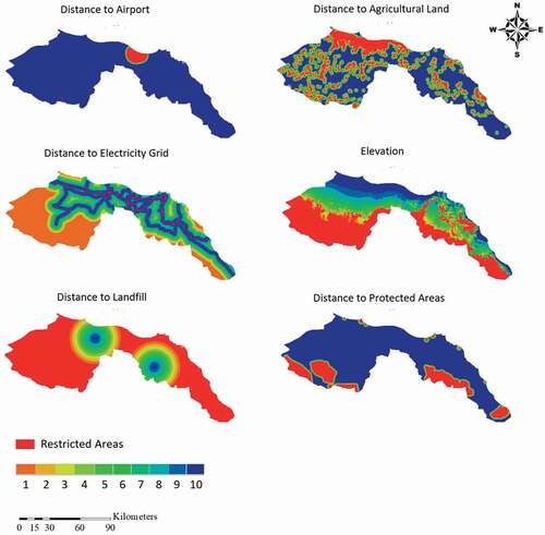
Figure 3. Suitability ranking of individual criteria, i.e., red (0) is restricted area, 1–4 represents low suitability, 5–7 represents moderate suitability, and 8–9 is highly suitable area.
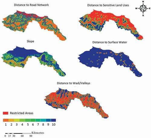
Moreover, as the distance from the shoreline, sensitive land uses and agricultural land increases, highlands start to appear that further limit suitability of land for incineration plant. The topographic nature of the study area has restricted almost 43% of the total study area, which occurs at elevations higher than 360 m (50% and 34% area in South Batinah and Muscat, respectively). Similarly, the slope at higher elevations is steeper than rest of the area, which will affect the technical feasibility of constructing an incineration plant. Therefore, in terms of the topographic nature of the study region, areas near the shoreline (lowlands and flat terrain), mainly in the northern parts, are highly suitable for establishing an incineration plant.
Waste transportation cost has direct impact on the feasibility of incineration plant, therefore, it is important to minimize the transportation as much as possible. Based on the consultation with experts, this study considered the maximum distance of 25 km from the landfill site, which has restricted 66% of the land in the study area. This classification prepared layers of each criterion in ArcGIS 10.8.1, which were integrated afterward based on the ranking of criteria.
Integrated suitability analysis
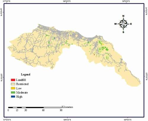
The suitability analysis of individual criteria doesn’t provide a comprehensive evaluation and can be misleading, especially when contradictory results are obtained by several criteria as shown in the suitability analysis. In this situation, weighted overlay provides an opportunity to conduct integrated suitability analysis and avoid contradictory results. The final map after weighted overlay shows the suitability categories within the study area. This study assigned three categories, i.e. low, moderate, and high suitability. Results presented in show that it is not possible to set up an incineration plant on 98% of the study area and only 2% is suitable. Among the suitable area, only 0.032% of the land falls under the highly suitable category, while moderately and low suitable areas account for 1.52% and 0.027%, respectively.
In the final output map (), it is obvious that a highly suitable site is not present in Muscat governorate. There are considerable sites with moderate suitability in the Al Amrat district of Muscat, however, most of the sites are not easily accessible due to the lack of road network. The limited access to the sites is due to the highlands that surrounds them. Therefore, setting up a plant in such areas will not only require extra cost to construct a proper road network, but it will also affect the fuel economy of the waste transportation trucks.
Figure 4. Integrated suitability maps with candidate site.
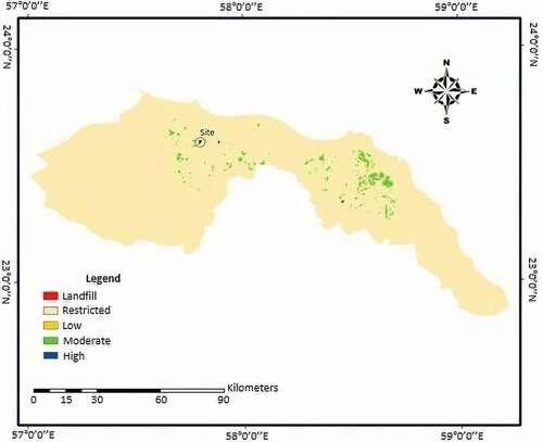
In South Batinah, potential sites are scattered in the central and northern parts due to high accessibility and closeness to the waste source (Barka landfill). The analysis revealed that three sites are highly suitable for constructing incineration plant in South Batinah, however, only one site has adequate area (2 km2). As shown in , this site is located at 23° 36ʹ5” N and 57° 48ʹ15” E in the district of Barka at approximately 7.5 km from Barka landfill that on average receives 1772 tonnes of waste daily. The location of the site is optimal because it is relatively close to the waste source and is surrounded by a road network (), thereby reducing the cost of transporting waste. It is also important to consider the wind direction when evaluating the suitability of site for incineration plant as the plume from stack flows in the direction of wind. The wind mainly blows from the northeast direction in the study area (Hereher, Al-Awadhi, and Mansour Citation2020), which makes the plant site ideal as it is located in the downward direction of the main settlements and agricultural land. This will save human settlements and agricultural land from any potential nuisance factors that may be produced by the incineration plant. In conclusion, the site identified in this study for constructing incineration plant satisfies all criteria and is optimal.
Figure 5. Integrated suitability maps with road network.
Conclusion
The construction of an incineration plant in the northern parts of Oman is key to manage the problem of growing amounts of solid waste and prolong the life of landfills. The selection of an inappropriate site for incineration plant could not only be detrimental to environment, natural resources and human health, but can also increase the economic cost. Hence, this study identified criteria, relevant to the situation of Oman, for the selection of incineration plant site. This research aimed to select a suitable site for an incineration plant in the northern governorates of Muscat and South Batinah to reduce the volume of waste as huge amounts of waste are disposed of in those governorates each day. The criteria ranks assigned by the regional experts showed that the distance to sensitive land uses, landfills, and road network have the highest influence, whereas distance to surface water, airport, and slope have the lowest influence on selection of suitable site for an incineration plant. The integrated suitability analysis found three most suitable sites in South Batinah and only one site, located in the northern part of the governorate, was deemed optimum for an incineration plant due to its sufficient area and closeness to Barka landfill. Results indicated that sites in Muscat have moderate and low suitability due to its topographic nature and high population density. Most of sites in the South Batinah governorate were moderate suitability due to the population density and agricultural land. Overall, only 144 km2 of the land was suitable for incineration plant in the study area, and only 3 km2 was found most suitable.
Acknowledgment
The authors acknowledge the support of Oman Environmental Services Holding Company (be’ah), National Centre for Statistics and Information (NCSI), Ministry of Housing and Urban Planning in Oman, and Oman Electricity Transmission Company S.A.O.C for providing the required data. The authors would also like to thank all experts that shared their knowledge and opinions on the subject under study.
Disclosure statement
No potential conflict of interest was reported by the authors.
Additional information
Funding
Notes on contributors
Mohammed F.M. Abushammala
Mohammed F.M. Abushammala holds a PhD (Year 2012) in Civil and Structural Engineering (Environmental Engineering), from The National University of Malaysia, Malaysia. He is an Associate Professor in Environmental Engineering at the Department of Civil Engineering, Middle East College (MEC), Oman. He is a well-informed and innovative educator in the field of Civil and Environmental Engineering at university and college level with 10 years of experience in teaching at different levels at assistant and associate professor. He is a senior fellow of the Higher Education Academy (SFHEA), and a member of the Institution of Engineering and Technology (IET). He has 12 years of research experience with a distinguished record of publications in the field of civil and Environmental Engineering. His research interest includes municipal solid waste management, waste to energy technologies, landfill gas emission and methane oxidation, biogas, and the application of expert system in environmental engineering.
Wajeeha A. Qazi
Wajeeha A. Qazi holds a BEng. in Civil Engineering (Environmental Engineering), from Middle East College, Oman. She is Research Assistant at the Department of Civil Engineering, Middle East College (MEC), Oman. Her research works focuses on life cycle assessment of municipal solid waste management, waste-to-energy technologies, landfill gas emission, and quantification of GHG emissions from waste systems.
Siham Frrag
Siham Farrag is currently working at Civil Engineering department, Middle east college, Oman. She obtained her PhD in Civil Engineering specialization, Transportation Science from Hasselt University, Belgium. Siham has more than 15 years of research experience in the field of transportation and Traffic Engineering. Her research interests focus on solving different transportation problems which included but not limited to the following topics: Traffic Safety, Drivers behavior, traffic management and traffic incident managements, intelligent transportation system (ITS), autonomous vehicles, impact of transportation on environment and air pollution, and Multi-Criteria Decision Analysis.
Motasem Y.D. Alazaiza
Motasem Alazaiza is an Assistant Professor at the Department of Civil and Environmental Engineering, at AꞌSharqiyah University, Sultanate of Oman. His research interest is in the transport of multiple fluid phases (water, oil, gases) in porous media and the mass transfer between those phases, with a particular specialization in the behaviour of gases in contaminated groundwater systems. My research is applied to understand the fate and transport of non-aqueous phase liquids (NAPLs) in soil and groundwater, develop and improve remediation technologies, and assess risks associated with unconventional resource development, and uses a combination of laboratory experiments and numerical modelling.
Mohammad K. Younes
Mohammad K. Younes is an Associate Professor at Philadelphia University – Jordan. His PhD in Civil Engineering and Built environment specialized in solid waste management. He has more than 10 years of research experience in the field of environmental pollution control and solid waste management as well as treatment technologies. His research interest focuses on multi criteria decision analysis implementation to solve the environmental issues like selecting the best treatment technologies, sitting undesired facilities. Moreover, he has a wide modeling experience using. He used AI tools to model some environmental related issues like traffic emissions, solid waste generation as well as solar radiation. He awarded many grant research locally and internationally.
References
- Abdallah, M., A. Shanableh, A. Shabib, and M. Adghim. 2018. Financial feasibility of waste to energy strategies in the United Arab Emirates. Waste Management 82:207–19. doi:10.1016/j.wasman.2018.10.029.
- Aderoju, O. M., G. A. Dias, and A. J. Gonçalves. 2018. A GIS-based analysis for sanitary landfill sites in Abuja, Nigeria. Environment, Development and Sustainability 22 (1):551–74. doi:10.1007/s10668-018-0206-z.
- Al-Jarrah, O., and H. Abu-Qdais. 2006. Municipal solid waste landfill siting using intelligent system. Waste Management 26 (3):299–306. doi:10.1016/j.wasman.2005.01.026.
- Alkaradaghi, K., S. S. Ali, N. Al-Ansari, J. Laue, and A. Chabuk. 2019. Landfill site selection using MCDM methods and GIS in the Sulaimaniyah Governorate, Iraq. Sustainability 11 (17):4530. doi:10.3390/su11174530.
- Chabuk, A., N. Al-Ansari, H. M. Hussain, J. Laue, A. Hazim, S. Knutsson, and R. Pusch. 2019. Landfill sites selection using MCDM and comparing method of change detection for Babylon Governorate, Iraq. Environmental Science and Pollution Research 26 (35):35325–39. doi:10.1007/s11356-019-05064-7.
- Chang, N.-B., G. Parvathinathan, and J. B. Breeden. 2008. Combining GIS with fuzzy multicriteria decision-making for landfill siting in a fast-growing urban region. Journal of Environmental Management 87 (1):139–53. doi:10.1016/j.jenvman.2007.01.011.
- Cheng, C., and R. G. Thompson. 2016. Application of boolean logic and GIS for determining suitable locations for temporary disaster waste management sites. International Journal of Disaster Risk Reduction 20:78–92. doi:10.1016/j.ijdrr.2016.10.011.
- Eskandari, M., M. Homaee, and S. Mahmodi. 2012. An integrated multi criteria approach for landfill siting in a conflicting environmental, economical and socio-cultural area. Waste Management 32 (8):1528–38. doi:10.1016/j.wasman.2012.03.014.
- Ferretti, V., and S. Pomarico. 2012. Integrated sustainability assessments: A spatial multicriteria evaluation for siting a waste incinerator plant in the Province of Torino (Italy). Environment, Development and Sustainability 14 (5):843–67. doi:10.1007/s10668-012-9354-8.
- Feyzi, S., M. Khanmohammadi, N. Abedinzadeh, and M. Aalipour. 2019. Multi- criteria decision analysis FANP based on GIS for siting municipal solid waste incineration power plant in the north of Iran. Sustainable Cities and Society 47:101513. doi:10.1016/j.scs.2019.101513.
- Hassaan, M. A. 2015. A GIS-Based suitability analysis for siting a solid waste incineration power plant in an urban area case study: Alexandria Governorate, Egypt. Journal of Geographic Information System 7:643–57. doi:10.4236/jgis.2015.76052.
- Hereher, M. E., T. Al-Awadhi, and S. A. Mansour. 2020. Assessment of the optimized sanitary landfill sites in Muscat, Oman. The Egyptian Journal of Remote Sensing and Space Sciences 23 (3):355–62. doi:10.1016/j.ejrs.2019.08.001.
- Hu, H., X. Li, A. D. Nguyen, and P. Kavan. 2015. A critical evaluation of waste incineration plants in Wuhan (China) based on site selection, environmental influence, public health and public participation. International Journal of Environmental Research and Public Health 12 (7):7593–614. doi:10.3390/ijerph120707593.
- Kamdar, I., S. Ali, A. Bennui, K. Techato, and W. Jutidamrongphan. 2019. Municipal solid waste landfill siting using an integrated GIS-AHP approach: A case study from Songkhla, Thailand. Resources, Conservation and Recycling 149:220–35. doi:10.1016/j.resconrec.2019.05.027.
- Malczewski, J. 1999. GIS and Multicriteria Decision Analysis. New York: John Wiley & Sons.
- Motlagh, Z. K., and M. H. Sayadi. 2015. Siting MSW landfills using MCE methodology in GIS environment (Case study: Birjand plain, Iran). Waste Management 46:322–37. doi:10.1016/j.wasman.2015.08.013.
- Nabavi-Pelesaraei, A., R. Bayat, H. Hosseinzadeh-Bandbafha, H. Afrasyabi, and K. W. Chau. 2017. Modeling of energy consumption and environmental life cycle assessment for incineration and landfill systems of municipal solid waste management-A case study in Tehran Metropolis of Iran. Journal of Cleaner Production 148:427–40. doi:10.1016/j.jclepro.2017.01.172.
- National Centre for Statistics and Information (NCSI). 2021a. Population of Oman. https://data.gov.om/OMPOP2016/population Accessed April 18, 2021a
- National Centre for Statistics and Information (NCSI). 2021b. National Geographical information architecture: Oman national spatial data infrastructure. http://nsdig2gapps.ncsi.gov.om/nsdiportal/. Accessed March 20, 2021b
- Oman Environmental Services Holding Company (be’ah). 2019. Annual Report 2019. https://www.beah.om//Other/AnnualReport. Accessed December 11, 2020
- Panepinto, D., and M. C. Zanetti. 2018. Municipal solid waste incineration plant: A multistep approach to the evaluation of an energy-recovery configuration. Waste Management 73:332–41. doi:10.1016/j.wasman.2017.07.036.
- Pasalari, H., R. Nodehi, A. Mahvi, K. Yaghmaeian, and Z. Charrahi. 2019. Landfill site selection using a hybrid system of AHP-Fuzzy in GIS environment: A case study in Shiraz city, Iran. MethodsX 6:1454–66. doi:10.1016/j.mex.2019.06.009.
- Qazi, W. A., and M. F. M. Abushammala. 2020. Multi-criteria decision analysis of waste-to-energy technologies. In Waste-to-Energy: Multi-criteria decision analysis for sustainability assessment and Ranking, ed. J. Ren. Elsevier, 265–316.
- Rajaeifara, M. A., H. Ghanavati, B. B. Dashti, R. Heijungs, M. Aghbashlo, and M. Tabatabaei. 2017. Electricity generation and GHG emission reduction potentials through different municipal solid waste management technologies: A comparative review. Renewable and Sustainable Energy Reviews 79:414–39. doi:10.1016/j.rser.2017.04.109.
- Şener, Ş., E. Sener, and R. Karagüzel. 2011. Solid waste disposal site selection with GIS and AHP methodology: A case study in Senirkent-Uluborlu (Isparta) Basin, Turkey. Environmental Monitoring and Assessment 173 (1–4):533–54. doi:10.1007/s10661-010-1403-x.
- Sisay, G., S. L. Gebre, and K. Getahun. 2020. GIS-based potential landfill site selection using MCDM-AHP modeling of Gondar Town, Ethiopia. African Geographical Review 40 (2):105–24. doi:10.1080/19376812.2020.1770105.
- Tavares, G., Z. Zsigraiová, and V. Semiao. 2011. Multi-criteria GIS-based siting of an incineration plant for municipal solid waste. Waste Management 31 (9–10):1960–72. doi:10.1016/j.wasman.2011.04.013.
- United States Environmental Protection Agency. (EPA) 2018. Waste management hierarchy and homeland security incidents. https://www.epa.gov/homeland-security-waste/waste-management-hierarchy-and-homeland-security-incidents. Accessed January 2, 2021
- Waste & Resource Action Programme (WRAP). 2012. A classification scheme to define the quality of waste derived fuels. Retrieved from https://dokument.pub/ql/a-classification-scheme-to-define-the-quality-of-waste-flipbook-pdf. Accessed January 20, 2021
- World Bank. 2000. Municipal solid waste incineration. Washington, DC: The World Bank.
- World Bank. 2022. Population of Oman. Retrieved from https://data.worldbank.org/indicator/SP.POP.TOTL?locations=OM. Accessed January 11, 2021
- Wu, Y., J. Wang, Y. Hu, Y. Ke, and L. Li. 2018. An extended TODIM-PROMETHEE method for waste-to-energy plant site selection based on sustainability perspective. Energy 156:1–16. doi:10.1016/j.energy.2018.05.087.
- Zavadskas, E. K., R. Baušys, and M. Lazauskas. 2015. Sustainable assessment of alternative sites for the construction of a waste incineration plant by applying WASPAS method with single-valued neutrosophic set. Sustainability 7 (12):15923–36. doi:10.3390/su71215792.