
 ?Mathematical formulae have been encoded as MathML and are displayed in this HTML version using MathJax in order to improve their display. Uncheck the box to turn MathJax off. This feature requires Javascript. Click on a formula to zoom.
ABSTRACT
Global trends toward urbanization will exacerbate traffic congestion, delays in economic productivity, and air pollution issues for growing cities. Traffic congestion pricing is one method available to help ameliorate these concerns. New York City is on the verge of implementing a cordon-based traffic congestion pricing policy around its central business district. For budget-constrained municipalities, evaluating implementation of such policy could be costly. This article proposes a sketch-planning methodology, called Cordon Screen, for major U.S. cities to evaluate the net income, traffic mitigation, and avoided pollution emissions from cordon-based traffic congestion pricing. This method relies on national datasets and limited user-specific data inputs, along with a range of user-selectable assumptions informed by academic literature to deliver order-of-magnitude results. The numerous limitations of this method are acceptable for preliminary policy evaluation to determine if greater financial investment to obtain more accurate results is justified. The Denver metropolitan area is used to demonstrate Cordon Screen capabilities, with mid-range assumption results suggesting the policy is most effective at generating net income and increasing vehicle speeds on major interstates. For Denver, the policy is comparably less effective at reducing air pollution and increasing speeds on minor roadways. Validation against early implementation results from the London cordon are acceptable. However, users should discount revenue generation projections. Choice of cordon area may be the most difficult obstacle when using the Cordon Screen. With refinement, Cordon Screen could serve as a low-cost, open-source planning evaluation tool for growing and congested U.S. cities.
Implications: As global urbanization trends continue, impacted local governments will be looking to explore policies to mitigate traffic congestion and reduce environmental emissions. Internationally, cordon-based traffic congestion pricing has been implemented in London, Singapore, and several other large cities. In America, New York City is implementing cordon-based congestion pricing around its central business district to reduce traffic and environmental emissions. Financial resource constraints, exacerbated by the COVID-19 pandemic, may limit the ability for local governments to invest in studying new policy options. The Cordon Screen method detailed in the manuscript presents a low-cost, open-source approach to assessing the potential benefits of cordon-based traffic congestion policy. The method utilizes national datasets to minimize user-specific data requirements and allows users to toggle between a range of values to test sensitivities to key assumptions. For example, emissions reductions are highly sensitive to how drivers respond to tolling. In this example, sensitivity testing enables users to understand how policy design can impact air quality goals. The Cordon Screen approach presented provides a strong platform for future stakeholder deliberation, refinement, and implementation.
Introduction and background
In 2018, approximately 55% of the world’s population lived in urban areas (United Nations Citation2019). As populations and economies grows, developed and developing countries alike will continue to urbanize. These trends have significant implications for travel and energy demand, and air quality in urban areas (Figueroa et al. Citation2014; Molina and Molina Citation2004). For example, increases in traffic congestion can negatively impact: economic productivity through delays in commerce, air quality through wasted fuel energy and idling, and commuter quality of life through lost value of time (Schrank, Eisele, and Lomax Citation2019). Traffic congestion pricing is one approach urban areas can explore to help mitigate traffic, reduce pollution, and raise revenues (Albalate and Bel Citation2009; Yu, Jia, and Shi Citation2009).
As identified by Pigou in his 1920ʹs “The Economics of Welfare,” traffic congestion is a negative externality (Pigou Citation1920). One person’s travel decision exerts costs on other commuters, the effects of which are exaggerated in dense urban areas. Congestion pricing charges drivers for access to and use of a high-demand roadway during a peak travel period (e.g., morning or evening rush hour). The financial penalty reduces travel demand, by shifting discretionary rush-hour travel to less congested off-peak times, increasing passenger per vehicle occupancy, and/or promoting substitute modes of transportation, such as public transportation, etc. Cordon-based congestion pricing charges motorist for entering a congested “cordon” area, such as a central business district. London, Stockholm, Singapore, and Milan have all implemented some form of cordon-based congestion pricing. In the U.S., New York City is preparing to implement the policy for the Manhattan central business district in 2023.Footnote1 The efficacy of the policy to reduce congestion and air pollution while raising revenues is well documented along with the policy’s limitations, such as concerns about equity, fairness, and limited political will (Albalate and Bel Citation2009; Santos, Fraser, and Newbery Citation2006; Larsen and Østmoe Citation2001).
Few resources exist to help municipalities evaluate cordon-pricing policy. This article aims to fill this gap through development of a sketch-planning method called Cordon Screen. Sketch-planning methods produce order-of-magnitude estimates of travel demand in response to transportation improvements to determine if more in-depth engineering analysis is justified (U.S. Department of Transportation: Federal Highway Administration Citation2004). Cordon Screen’s sketch-planning approach was informed by the “Balanced Transportation Analyzer” (BTA) model developed by Charles Komanoff (Komanoff Citation2020), and used to analyze cordon tolling strategies for the central business district of New York City (FIX NYC Advisory Panel Report Citation2018). Beyond the New York-specific BTA, there are few publicly accessible resources for municipalities to draw from. The travel model improvement program’s (TMIP’s) publicly accessible, excel-based “Roadway Pricing Feasibility Screening Tool – Beta” can output revenue and traffic impacts of new toll road construction, but not congestion pricing.Footnote2 In Citation2019, Xie et al. performed a review of 16 sketch planning methods that quantify traffic and environmental emissions related to traffic flow improvement projects (Xie, Chen, Jiang, & Ren, March 2019). They found only four of these tools were available online and of these four, none modeled congestion pricing.
This research proposes an urban cordon tolling policy evaluation sketch-planning method, called Cordon Screen.Footnote3 Cordon Screen requires limited user-specific data inputs, relies on national datasets wherever possible, incorporates well-understood methods, and allows users to choose between a variety of key assumptions. Outputs include order-of-magnitude level results for traffic congestion mitigation, avoided environmental emissions, and revenue generation. Local policymakers can use Cordon Screen to determine if additional resources should be devoted toward obtaining a more detailed understanding of the costs and benefits of implementing a congestion pricing policy. Cordon Screen is only applicable to U.S. municipalities with municipal planning organizations or MPO’s that maintain the required data inputs.
The remainder of this article outlines the sketch plan methodology and resources used to support the methods. To highlight the method’s capabilities, this study uses data from the Denver metropolitan area as a case study. The results of the case study are summarized, a discussion of Cordon Screen and its limitations is included, rounded out by a conclusion and next steps.
Methodology
A simplified Cordon Screen workflow diagram is available in Supplementary Figure 1 and complete list of the user drop-down box options and related data resources is included in Supplementary Table 1.
Transportation and travel methods and data
This section describes the methods and national datasets used to establish value ranges for transportation and travel assumptions and subsequent calculations. The user must first define the cordon area that will be used to generate vehicle trip volume data. For simplicity, Cordon Screen employs a single cordon area design, though there are benefits to dual cordon (inner and outer rings) designs (Sumalee Citation2001). Once the cordon area is selected, traffic trip volumes and vehicle classification data per roadway functional type can be supplied by the local MPO. These data should come from continuous or short-duration traffic count stations closest to the cordon area boundaries. These data are likely to be in the form of actual or estimated annual average daily traffic (AADT) metrics. The AADT is often calculated with the factor method using a two-day sample set and the following equation:
where Vol is the 24-h volume count, SF is the applicable month/day seasonal factor, and AF is the applicable axle correction factor (e.g., for commercial vehicles). Though not ideal, calculating the AADT using the factor method and limited empirical data (24, 48, 72 hours) is a widespread practice (Islam Citation2016). The traffic count station data should also contain vehicle classification (e.g., light duty and heavy duty) distribution, which influences assumptions about trip purpose. The reasons motivating a driver’s trip impacts assumptions of demand elasticity to toll price. For example, trips related to work tend to be less elastic than recreational trips. Also, commercial trips are less elastic than noncommercial trips.
A certain number of trips crossing the cordon will be through-trip traffic – meaning the vehicle crosses into and out of the cordon but does not stop inside the cordon – and/or traffic that is not accounted for in the system and therefore cannot be easily tolled (e.g., out-of-state registered vehicles). The BTA assumed 32% of all light-duty vehicle (LDV) entries into the cordon would be through trips and 27% of all heavy-duty vehicle (HDV) trips were through trips, based on a New York specific analysis. In absence of location-specific data, Cordon Screen incorporates the 32% and 27% value as a mid-range sensitivity for LDVs and medium duty vehicles (MDVs)/HDVs, respectively. Some through trips will pass into and out of the cordon once per day and others will pass through more than once per day. The user has the option to determine the percentage of one-way through trips with the mid-range assumption of 20%, which was taken from the BTA. The user also can choose to toll repeated through-trips once or twice. If the trip is not a through trip, it is assumed to be a round trip. For example, every vehicle on a round trip is expected to enter (or exit) the cordon, stop within (outside) the cordon, and exit (reenter) the cordon. Users will have to select their assumption about the number of one way through trips. Given the limited source data, these assumptions should be reevaluated over time, and is considered an area for future research.
Low-end assumptions about LDV work-related trips were taken from the 2009 NHTS (U.S. DOT’s Federal Highway Administration Citationn.d.) and high-end assumptions were taken from the NYC BTA at 35% (Komanoff Citation2020). There is an opportunity to collect better national data on high-end work-related trip assumptions. All other LDV trips were assumed to be non-work related. Cordon Screen assumes all MDV and HDV trips are commercial and would respond to tolls only by time or route shifting. This is an assumption that should be revisited or replaced with better municipal-specific data, if available.
Volume data from trip count stations does not include VMT per trip, as this metric requires more rigorous analysis of trip origin and destination. To incorporate VMT for LDVs, 2018 origin-destination employment statistics were taken from the U.S. Census’ Longitudinal Employer-Household Dynamics (LEHD) database (U.S. Census Longitudinal Employer-Household Dynamics Citation2018). Distances were determined for all jobs traveling from home census block to work census block, where work is assumed to be inside the cordon. For simplification, mean travel distances from home to work were categorized in four bins and apportioned to trip volume data by percent distribution. No other data was available to translate LDV non-work or through trips to VMT, so the LEHD data was also applied to these trips. For HDV and MDV through trips the VMT distance associated with each trip was calculated by the mean distance of interstate and state highway crossings through the cordon. The MDV and HDV intra-cordon trips – meaning they enter the cordon for a specific reason, such as a delivery of freight – was calculated as the mean distance of a 19 × 19 array of connecting latitude and longitude points along the cordon. Cordon Screen can calculate the intra-cordon distance and mean highway distance, provided the latitude and longitude of relevant trip count stations are supplied, otherwise the MPO can provide these distances.
To estimate the efficacy of the cordon toll in reducing congestion the pre- and post-tolling trip volume flow data is translated into vehicle speeds using the Bureau of Public Roads (BPR) method in EquationEquation 2(2)
(2) , where s is the predicted mean speed, sf is free flow speed, v is volume, c is practical capacity,
is a parameter that determines the ratio of free-flow speed to the speed at capacity, and
is a parameter that determines how steeply the speed-flow curve bends at capacity.
Variations of the BPR formula, which was introduced in 1964, have been widely used by transportation planners for traffic assignment (Dowling Associates, May 1999). This method is employed given its match to the available data inputs and relative simplicity of approach. To test for output sensitivity, two scenarios were explored, a detailed scenario and a simple scenario. For the detailed scenario, roadway type counts are matched to tabled values in the 2000 Highway Capacity Manual (HCM) for and
parameters (Chapter 30, Areawide analysis, Appendix C), default free flow speeds (Chapter 10), and capacity at level of service C (which generally corresponds to default table assumptions) (Transportation Research Board Citation2000). For the simple scenario, early guidance on the BPR inputs from the HCM were used including assuming practical capacity is defined as 80% of capacity, free flow speed is 1.15 times the speed at practical capacity,
is 0.15, and
is 4 (Transportation Research Board Citation2000; Dowling Associates Citation1999). Comparing the results of the detailed and simple scenarios will provide insight into the tradeoffs of using these approaches. The TMIP’s sketch planning tool for toll road construction also uses the BPR equation assuming a level of service C with
is 0.15,
is 4.Footnote4
Economic methods and data
How drivers will respond to the toll and how sensitive they will be to toll price are the two main factors Cordon Screen uses to determine post-toll trip shifts and trip reductions. In the short-term, motorists can respond to congestion pricing by changing routes (route shift), timing of trips (time shift), to different modes (mode shift), trip destination (destination shift), trip occupancy, or total trips (trip generation or abandonment). Cordon Screen only considers short-term responses to roadway pricing and does not consider the broader long-term economic impacts of this policy that include but are not limited to relocation of commuter/laborers, land-use change, and other impacts (Safirova et al. Citation2006) (Zhong et al. Citation2015). Specific to this section, transportation elasticities tend to increase over the long-term as drivers have time to incorporate toll costs into their decisions (e.g., relocating within the cordon zone or closer to public transit) (Litman Citation2019).
The most useful data applicable to this study is initial implementation of cordon-based pricing schemes. Data from initial implementation of the Singapore area license scheme (ALS) suggests work commuters into the cordon area in 4+ persons high occupancy vehicle carpools increased from 8% to 19%, bus transit (and park and ride) ridership increased from 33% to 46%, and the number of work commuter drivers who time shifted to non-peak from peak periods went from 28% to 42% (Transportation Research Board of the National Academies Citation2003). Implementation of tolling cordons in Norway found from 3% to 13% of work-based trips (in the Trondheim toll ring) time-shifted based on time-of-day pricing and weekday bus travel increased by 7% (Transportation Research Board of the National Academies Citation2003). Peak hour bus use in London increased by 14% in response to cordon tolling (Transportation Research Board of the National Academies Citation2003). A pilot cordon-based congestion pricing scheme was implemented in Stuttgart, Germany that resulted in 12.5% of drivers switching to cheaper routes, an additional 5% switching to weekday public transit, and another 7% switching to carpools (Transportation Research Board of the National Academies Citation2003).
Toll increases to previously tolled single routes or roads where time of day or variable pricing is used, may also inform how drivers may respond. A study of dynamic congestion pricing in Miami showed that 6% of riders switched routes in response to tolled lanes and there was a 13% increase in ridership on bus routes on the tolled road (Pessaro and Nostrand Citation2014). A 2010 study of time-of-day pricing on tunnels and bridges controlled by the Port Authority of New York and New Jersey found that 7.4% of passenger trips changed behavior in response to the tolls, noting inelastic demand in the range of −0.11 to −0.24 depending on time of travel and payment method (Holguı´n-Veras et al. Citation2011). Approximately 4.6% of passenger trips time-shifted, 1.9% changed mode to public transit and 0.64% changed occupancy (carpooling) in response to switching from regular to dynamic tolling (Holguı´n-Veras et al. Citation2011). Good data sources for trip abandonment could not be located, and therefore were excluded from the user defined options. A placeholder for these data is included for future refinement. shows the range of driver response assumptions users can toggle between, which were primarily informed by initial cordon implementation data and therefore do not represent long-term driver behavior. Each response is divided by the appropriate scaling factor to ensure to ensure driver responses do not exceed total demand response elasticity.
Table 1. Assumption ranges available for driver responses to cordon toll.
A robust travel demand model may incorporate demand elasticity with respect to price (cost), income, and travel time. Demand elasticity to toll price are reported as a point or range but can change with respect to not only toll price, but also the type of trip (work, recreational), income of motorist (low to high), travel conditions (peak, off-peak), and duration considered (short to long term). Short-run elasticities are appropriate to use to reflect changes in traveler behavior from initial imposition of the congestion fee, rather than long-run elasticities that would reflect more significant responses (e.g., moving to a new location, changing the number of vehicles) (Dong et al. Citation2012). In general, commercial travel, work commutes, high-income travelers, weekday trips, and urban peak period trips tend to be less elastic compared to their respective counterparts that include personal travel, recreational/shopping trips, low-income travelers, weekend trips, and off-peak/rural trips (Litman Citation2019).
Log arc price elasticity () in EquationEquation 3
(3)
(3) refers to the change in consumption (Q) associated with a 1% change in price (P). The transformed method solving for Q2 is used for LDV elasticity calculations. P1 and Q1 are the initial price of travel and quantity of travel demanded (respectively), P2 is the price of travel with the toll, Q2 is the travel demand quantity after the toll, and
is the elasticity value. The range of elasticity values available in the user drop-down box rely on elasticities reported from real-world implementation of cordon or area pricing as shown in . The mean daily price of travel (P1) was determined by using the 2018 Consumer Expenditure Survey quintiles of transportation expense that are scaled to national income quintiles (U.S. Bureau of Labor Statistics Citation2018). To match these travel expense data to cordon-specific income quintiles, applicable regional household income and worker commuting data was taken from the U.S. Census American Community Survey (Census ACS) 5-year estimates for 2013–2017 through GIS shapefiles (U.S. Census Bureau Citation2017). This allows all LDV trips to be broken down by income quintiles with the appropriate P1 values applied to reflect the different price sensitivities of the driving population more accurately. Thru-trips elasticities for LDVs are weighted averages of elasticities for work and non-work trips.
Table 2. Cordon toll price elasticity assumptions and sources.
MDV and HDV average transportation expenses for P1 are calculated on a per mile basis using 2019 trucking cost data for the applicable U.S. region, prepared by the American Transportation Research Institute (American Transportation Research Institute, November Citation2019). Daily mileage for single unit (MDV) and combination trucks (HDV) were calculated using 2018 average annual miles traveled data from the FHWA (Federal Highway Administration, Citation2018a). MDV and HDV toll elasticities for commercial freight range from −0.35 to −0.51 and are assumed to time-shift or route shift (Gomez and Vassallo Citation2015). Users are required to choose among the drop-down box elasticity values for LDV work, non-work, and through trips; and MDV and HDV intra-cordon and through trips.
A minimum of three toll pricing strategies are currently available in Cordon Screen, including peak, dynamic, and flat rate pricing, which are detailed in Supplementary Table 2. These strategies toll only trips coming into the cordon, which is consistent with the idea of reducing intra-cordon volumes. Cordon Screen could easily be modified to toll outbound trips, for example, if the municipality-valued revenue generation or emissions reductions over intra-cordon traffic mitigation. More complicated pricing schemes, such as distance-based tolling or dynamic optimization exist but are not considered (Ru-xue & Lan, Citation2021) (Chen, Wu, Huang, & Shang, Citation2022). Initial toll prices for the applicable region were based on the BTA peak-period proposed NYC toll price of $12.24, scaled to the applicable region through a cost-of-living adjustment.
Implementation costs include the capital cost to deploy electronic toll collection (ETC) infrastructure and the annual operating cost to administer and enforce the system. ETC infrastructure capital costs may include overhead gantries and other mounting infrastructure fitted with automatic license plate recognition (ALPR) cameras, dedicated short-range communications transponders and receivers, back-office servers, and information technology systems to process toll data and billing, etc. Operating costs may include maintenance, staffing, enforcement, etc. Limited data on current capital and operating costs was available. Based on 2008 data, the BTA assumes $480,000 per field unit plus a 4x multiplier to deal with community relations, siting, and installation for an installed cost of $1.92 million per unit. The BTA assumes 21 field unit locations ($40 million total) plus $109 million in capital costs for a central processing system. Operating costs include $20 million for administration, and $40 million for processing. More recent data suggests $1 million per entry zone point for toll readers, lane computer, and enforcement systems, $40 per foot for fiber optic cable, and $400,000 for back-office account management, transaction processing, enforcement, and software (McQueen Citationn.d.). Empirical data suggests operating expenses can range from 7% to 67% of total annual income (Ruja Citation2011). Here, it is assumed that each entry point costs $1 million per station in capital cost, $400,000 per station per year in operating costs, and $109 million total in upfront capex for central processing infrastructure. Total entry points will be dependent on the applicable cordon size and configuration. This does not incorporate costs for cables, signage, education and outreach, or marketing. There is an opportunity to collect more recent and refined data on implementation costs. Net income is calculated by amortizing initial capital expense over 5 years using a 3.9% interest rate and 12 payments per year, then deducting the amortized capex and annual operating expenses from annual revenues. Daily revenues are calculated based on daily tolls collected and annual revenues assume 253 weekdays in 2018. All eliminated trips collect zero toll revenues. Time shifted trips are assumed to change trip timing to the cheapest hour available in the respective rate plan, resulting in complete or partial toll revenue reduction for each trip. Route shifted trips are assumed to change routes to avoid all cordon tolls, with a commensurate revenue reduction.
Environmental methods and data
Three sources of emissions rates were used to provide a range of potential avoided emissions scenarios (i.e., high, mid, and low). For example, the high avoided emissions scenario uses average emissions rates for the LDV population that are higher than the rates used in the medium and low avoided emissions scenarios and therefore will result in a greater quantity of avoided emissions, all things equal. Emissions rates used cover only emissions associated with running exhaust and exclude emissions from other portions of the drive cycle (e.g., startup, break, tire ware). Calculation of avoided emissions are only related to eliminated LDV trips and do not consider the emissions reductions associated with improved travel efficiency from reduced congestion. Toll avoidance (e.g., route and time shifting) is handled as a reduction in avoided trip, therefore incrementally increasing emissions. Further increases to emissions from toll avoidance or the rebound effectFootnote5 are not considered. The emissions rates used are included in . These rates do not account for how the composition of the built urban environment in and around the congestion pricing area impacts emissions reductions (Zhong & Bushell, Impact of the built environment on the vehicle emission effects of road pricing policies: A simulation case study, Citation2017).
Table 3. Pollutant emissions rates used for high, mid, and low scenarios.
The high avoided emissions scenario uses 2018 estimated national average emissions rates for gasoline LDVs published by the Bureau of Transportation Statistics in its National Transportation Statistics compilation (Bureau of Transportation Statistics Citation2018). These rates were limited to four key pollutant metrics: NOx, CO, Total hydrocarbons, and PM 2.5. The mid-range avoided emissions scenario uses emissions rates calculated by the GREET (Greenhouse gases, Regulated Emissions, and Energy use in Transportation) model as implemented by Argonne National Labs (Cai, Burnham, & Wang, September Citation2013). This scenario uses emissions rates for gasoline LDV’s from model year 2006, based on the Bureau of Transportation Statistics data suggesting the average age of U.S. LDVs is 12 years (2018 modeling year −12 years = 2006 model year) (Bureau of Transportation Statistics). The low avoided emissions scenario uses emissions rates calculated by the California Air Resources Board’s online EMFAC tool (California Air Resources Board). The EMFAC 2021 V1.0.0 on-road, statewide annual emissions rates for 2018 assume aggregated model year and speed, and only include gasoline LDVs.
Cordon Screen models roadway pricing on weekdays due to the associated increase in traffic volumes. However, while many associated ambient air pollutant concentrations in urban areas decrease on weekends (compared to weekdays), others such as O3 may increase depending on air mixing, precursor emissions, and other factors (Blanchard, Tanenbaum, and Lawson Citation2008).
Data
To demonstrate the Cordon Screen capabilities, a case study was performed using data for the Denver Metro region. Owing primarily to economic growth, between 2000 and 2017, the Denver regionFootnote6 has seen vehicle miles traveled (VMT) (38%) and population (31%) growth rates well above national average VMT (17%) and population (15%) growth rates (Denver Regional Council of Governments Citation2018). Forecasts predict a 33% increase in freeway and arterial VMT between 2017 and 2040, raising the total economic cost of delay by 71% from $1.64 billion to $2.8 billion annually (Denver Regional Council of Governments Citation2018).
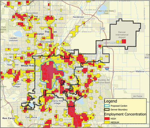
Shown in light blue in , three key criteria were used to determine the cordon area for Denver: 1) predicted increases in traffic congestion, 2) forecasted population growth, 3) and geographic concentration of employment. Key congested corridors in the Denver region are clustered around the city center, with congestion predicted to increase in these areas in the future, see . The cordon corresponds with locations projected to have high population and job growth rates (City and County of Denver, April 22, Citation2019) and increases in traffic congestion (Denver Regional Council of Governments Citation2018), but excludes the home rule municipality of Glendale. Employment concentration data was made available from the local MPO, the Denver Regional Council of Governments (DRCOG) (Denver Regional Council of Governments Citation2016). DRCOG took data from the Colorado Department of Labor and Employment’s Quarterly Census of Employment and Wages and Infogroup and performed kernel density analysis in quartiles. The lowest two quartiles were dropped, and the highest two quartiles are identified in as “medium” (in yellow), and “high” employment concentration (in red). The 21.5 square mile cordon shown in surrounds the largest contiguous area of high employment concentration in the downtown Denver region.
Figure 1. Denver congested corridors 2018 (purple) and 2040 (red) (DRCOG regional data catalog).
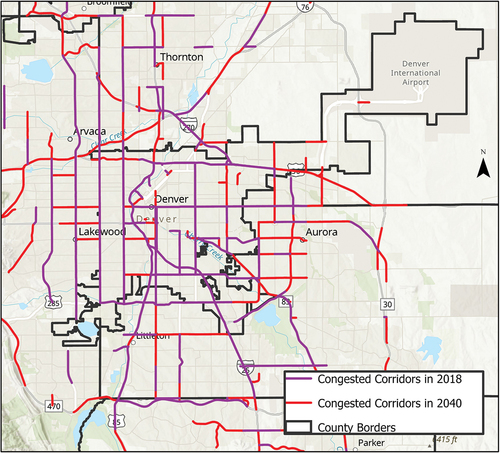
Figure 2. Proposed Denver cordon area and employment concentrations.
The population density of the city under consideration will meaningfully impact the size of the cordon. For example, the BTA lists the New York City cordon area as 8.5 square miles with an expected 701,100 weekday inbound trips (Komanoff Citation2020). The less densely populated Denver cordon has an inbound weekday trip count of 851,647 over a much larger 21.5 square mile area. The proposed Denver cordon is larger than most cordon areas, such as: Singapore (2.7 sq. miles), Milan (5 sq. miles), London (16 sq. miles including central and former western zones), and Stockholm (13.5 sq. miles). This is primarily due to comparatively lower development density. Most cordon areas are designed using professional judgment of planners, though more effective design methods may exist to maximize social benefit (Shepherd, May, and Koh Citation2007). The geographic design of the Denver cordon area may be suboptimal, as it is inconsistent with certain best design practices such as incorporating natural boundaries to entry that inter alia serve to reduce implementation costs (Sumalee Citation2001). Planners will need to consider a host of additional factors beyond the scope of this paper when determining cordon design, including but not limited to impacts to low-income households and businesses within the cordon, increases in traffic outside of the cordon, and public transit expansion investments.
Traffic trip volume and vehicle classification data for highways and major roads was taken from the Colorado Department of Transportation’s (CDOT) Transportation Data Management System (TDMS) (Colorado Department of Transportation Citation2020). For the remaining roadways not covered by the TDMS, projected 2020 all-day traffic volume data were taken from DRCOG (Denver Regional Council of Governments). Trip volume data did not exist for some smaller roadways into/out of the cordon and were therefore excluded, reducing the accuracy of the analysis. For the TDMS, volume data for each continuous or short-duration traffic count station location was available on an hourly, weekday basis for each direction of bidirectional roadways. AADT volume data generally dated within the 2013–2019 range, with a few exceptions prior to 2013. For older data, hourly distribution of volumes was preserved while normalizing total volumes to the 2019 AADT for each roadway and direction. Vehicle classification information was also normalized to the 2019 AADT.
The DRCOG data was only available for total volumes in a 24-h period with no useable directional or hourly detail. As a course refinement, the total 24-h volume per roadway was halved for each direction then an average hourly distribution from the TDMS for roadways of similar functional classFootnote7 was applied (see ) as well as an average vehicle classification distribution. The TDMS provided vehicle classification data associated with volume counts based on the Federal Highway Administration’s (FHWA) 13-category classification system. For the largest volume highways where CDOT classification did not exist, the FHWA Highway Statistics classification data was used (Federal Highway Administration, 2018). These adjustments were necessary given the limitations of the publicly available data. For municipal users of Cordon Screen, the intention would be for the MPO or state transportation agency to provide these data with any necessary adjustments.
Figure 3. Volume flows into and out of Denver cordon.
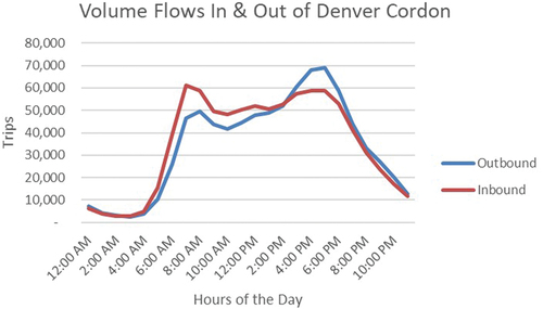
LDV, MDV, and HDV counts were provided for a specific period (i.e., not by hour) for many of the TDMS roadways. From these data, an average vehicle classification distribution was calculated and applied to each hour of the day. For example, in Denver, the vehicle classification distribution for weekday volumes inbound to the cordon was 93.6% LDV, 2.35% MDV, and 4.04% HDV. For distance per trip, the percent distribution in the four bins of trip distance for Denver were 5 miles (68.8%), 17 miles (22.8%), 37.5 miles (2.9%), and 50 miles (5.5%). For HDV and MDV through trips were calculated at 6.07 miles and intra-cordon trips were estimates at 2.82 miles.
Results for Denver
Inducing results by adjusting settings is not advised since these outputs will not represent reality. Rather, such manipulation provides upper (or lower) bounds of results, provided drivers respond accordingly. In theory, to maximize revenues the total number of trips should stay high (i.e., low demand elasticity to toll price values) and the highest revenue generation options should be applied (e.g., dynamic pricing, with high toll multipliers for HDV/MDVs). To maximize emissions reductions, the total number of trips reduced should be maximized by incorporating high demand elasticity values, BTS national emission rates should be selected, and the highest values for occupancy and mode shifts incorporated. To maximize congestion mitigation, the total number of trips reduced should be maximized (see above), plus incorporate the detailed assumptions about volume-to-speed conversion.
To highlight the results for Denver, mid-range values are used for the travel and economic assumptions. Outputs for flat rate and dynamic pricing are compared, along with differences in environmental and congestion mitigation outcomes. The results for a typical weekday are presented in .
Table 4. Sample results for mid-range travel and economic assumptions.
After contextualizing these results, it seems given the assumptions employed the cordon-based congestion policy is quite effective in raising revenues and less effective in reducing traffic congestion or avoiding emissions. Cordon Screen indicates the congestion pricing policy modeled generates significant revenues of more than $4 million per day and net income of approximately $1 billion per year for both the peak and dynamic pricing strategies. Compared to the peak and dynamic pricing plans, the financial results for the flat rate scenario are more than half the daily revenues and annual net income.
Congestion mitigation results, represented as percentage speed increases per time-period, are modest and very sensitive to the volume-to-speed scenario assumptions. For example, compared to the simple scenario, percentage speed increases almost double for the detailed scenario. These percentages seem insignificant and are somewhat misleading given they are average speed reductions across all roadways and across the hours including in each time tranche. provides the results for the dynamic pricing scenario in more detail and shows the most significant speed increases occur on the largest roadways, which may be extremely attractive to some municipalities. This may be less attractive to municipalities dealing with congestion on smaller roadways.
Table 5. Traffic congestion mitigation percent speed increases for the morning and afternoon peak periods.
To contextualize the emissions results, total avoided emissions are compared to the motor vehicle emissions budget for ozone (2017), PM10 (2015–2021), and carbon monoxide (2021) for Denver non-attainment areas as identified in the summary Colorado State Implementation Plan (Regional Air Quality Council, October 2019). These results shown in suggest the congestion pricing scenario (i.e., dynamic pricing with mid-range assumptions) would equate to less than a half of 1% of the daily motor vehicle emissions budgets for these pollutants. When comparing emissions reductions to the baseline LDV emissions, the results generally scale to the percentage of LDV miles eliminated. For the same scenario, approximately 4% of LDV miles are eliminated generally equating to a 4% reduction in pollutant emissions. The environmental results are obviously sensitive to the emissions rate scenario chosen. The limited nature of avoided emissions is primarily due to assumptions about driver response. Only mode shift, trip abandonment, or occupancy increases will result in emissions reductions. Drivers that respond to tolls by changing routes or timing of trips will not avoid and may increase emissions.
Table 6. Contextualizing avoided emissions based on Denver non-attainment area motor vehicle emissions budgets.
Empirical data to validate Cordon Screen results for Denver were not available. Drawing comparisons between the Denver outputs to results from initial cordon policy implementation in other jurisdictions is complicated given heterogeneity in policy goals, inputs, and assumptions. Nevertheless, Supplementary Table 3 compares the Denver Cordon Screen results using dynamic pricing and mid-range assumptions to empirical data from initial implementation of the London central cordon charging scheme, along with a Denver scenario with assumptions generally normalized to London’s experience (Transport for London Citation2003; Transport for London Citation2004; Evans Citation2008; Transport for London Citation2005). The results show adjusted Cordon Screen results performs well with a few exceptions. London experienced far greater emissions reductions, which could be a function of the higher emissions rates from older vehicles offering greater emissions reductions per trip eliminated (average age of vehicles in 2003 compared to 2018 in Denver). London’s revenues and net income were far lower and the costs far higher than the Cordon Screen results; however, the amounts are closer when scaled with a 2.2x multiplier to adjust for the greater volume of trips in Denver. The remaining difference could be due to the differences between planning and implementation. In London, actual toll revenues where far lower than projected revenues (attributed to the greater than expected impact on traffic), penalties from failure to pay accrued tolls were higher than expected, and implementation costs were higher than projected (Leape Citation2006). In addition, Cordon Screen does not incorporate toll exemptions, discounts, and uncollected but accrued tolls, all of which would reduce expected revenues below projections (Leape Citation2006). It will be important to emphasize to users that revenue projections should be discounted.
Discussion and limitations
The Cordon Screen method estimates the short-run impacts of cordon-based congestion pricing implemented on weekday traffic; it does not look at long-term impacts. This could provide inaccurate impressions to municipal users about the policy’s benefits because long-run economic, land use, and travel pattern responses to the toll are ignored. A municipality interested in cordon pricing after using Cordon Screen will need to devote additional resources to understanding long-term impacts of the policy.
Empirical measurement of volume data was limited, and in most cases AADT’s were calculated based on the factor method using short duration counts, rather than continuous count data. Volume data for all roadways into and out of the cordon was not available. Vehicle classification data was available for many roadways, but not broken down on an hourly basis. Data was not available to provide the best estimation of vehicle speeds, and origin-destination data by trip was not available. The impact on specialty trips – such as taxi’s, Uber/Lyft, delivery trucks – was not addressed due to lack of available baseline data. A travel demand model would be needed to address these shortcomings.
The Cordon Screen method does not include a comprehensive understanding of individual or societal benefits and drawbacks. Some additional benefits may include improved safety from fewer traffic accidents and increased economic productivity from less congestion. Some additional drawbacks might be impacts to area businesses, congestion outside of the cordon areas, and equity concerns. Cordon Screen does not account for changes in transportation fuel prices, which may impact driver response to toll pricing by changing the baseline cost of driving. Lastly, the toll prices scenarios are not informed by an analysis of marginal societal costs. Comprehensive economic analysis (e.g., general equilibrium and welfare analysis) would be needed to address these shortcomings.
The pollutant emissions rates used are limited, are not specific to the urban area being studied, and may under or overestimate potential avoided emissions depending on the assumptions and scenarios chosen. The emissions rates include only running emissions, likely leading to underestimation of total avoided emissions, all things equal. The Cordon Screen method does not incorporate complicated air mixing or upstream emissions and therefore cannot be used to estimate how the policy will impact compliance with certain air quality regulations (e.g., ozone). More detailed pollutant emissions and air mixing modeling would be required to address these shortcomings.
Beyond the design shortcomings of Cordon Screen, municipalities will have to consider complex aspects of designing and implementing this policy including, but not limited to, the role of public transit investments, equity issues, and political challenges with implementing a new tax. In fact, a key design feature to gaining public acceptances of congestion pricing is using revenues to expand and improve public transportation (Jaensirisak, Wardman, & May, May Citation2005) (Albalate and Bel Citation2009). Public opposition can occur as motorists face new fees for roadway access that they are accustomed to using for free. Congestion pricing can be publicly and politically controversial, though design features and use of revenue have a large impact on public acceptability levels (Jaensirisak, Wardman, and May Citation2005).
Conclusion
Cordon Screen can enable municipalities to better understand the benefits of cordon-based roadway pricing. It is meant to be a free and simple screening tool and should not be relied upon as a municipality’s only means of policy analysis. Cordon Screen limits unique data inputs, however, interested urban areas must define the cordon area(s) of interest, identify related hourly traffic volumes, provide roadway and vehicle classification data, and input the preferred distance for inter- and intra-cordon crossings. It is reasonable that most large municipalities would have this capacity through existing MPO’s, but this capability is an assumption. To reduce controversy about the location of the cordon area, municipalities may choose to model several cordon areas at the screening stage. This will increase unique data input requirements, while also providing potentially useful data to inform the cordon location decision.
Cordon Screen’s numerous limitations may be acceptable if the user is interested in conserving financial resources while obtaining order-of-magnitude insights. This may be an appropriate first step prior to more in depth and costly analysis of travel demand, economic costs and benefits, and environmental outcomes, as well as differentiating short-term and long-term impacts. Cordon Screen is sensitive to user-defined option values, but these options are useful to provide upper and lower bounds on results.
This article provides the basis for a preliminary sketch planning method for municipal evaluation of U.S. cordon tolling policy. Future refinement of the Cordon Screen tool should focus on stakeholder-user and expert input to improve upon this initial approach. This should include input from municipalities, MPO’s, and other stakeholders. Key sensitivities could be incorporated for topics, such as revenue adjustments (i.e., from exemptions and discounts), public transit investments, estimating congestion impacts outside the cordon area, and a low-income community impact analysis. In addition to developing a brief user guide to accompany Cordon Screen, a short guidance document could be developed to help users plan the next steps in the analytic process.
Data availability
The authors agree to allow the excel-based model (in write-protected form) with underlying data to support the analysis to be made available to the public at https://data.mendeley.com/datasets/gk7ysbvzd7/1
Supplementary_Table_3.docx
Download MS Word (13.7 KB)Supplementary_Table_2.docx
Download MS Word (14.9 KB)Supplementary_Table_1.docx
Download MS Word (16.7 KB)Supplementary_Figure_1.docx
Download MS Word (49.7 KB)Acknowledgment
The authors wish to thank Marcelo Duarte for his excellent tutoring on GIS software functionality. This work was included as part of Mrs. Simeone’s PhD thesis, which included research assistant/internship at the National Renewable Energy Laboratory. This work was authored in part by the Joint Institute for Strategic Energy Analysis (JISEA) and the National Renewable Energy Laboratory, operated by Alliance for Sustainable Energy, LLC, for the U.S. Department of Energy (DOE) under Contract No. DE-AC36-08GO28308. Funding provided by the Joint Institute for Strategic Energy Analysis. The views expressed herein do not necessarily represent the views of the DOE, the U.S. Government, or sponsors.
Disclosure statement
No potential conflict of interest was reported by the author(s).
S upplementary material
S upplemental data for this paper can be accessed on the publisher’s website
Additional information
Notes on contributors
Christina E. Simeone
Christina E. Simeone is a Ph.D. candidate in the Advanced Energy Systems program jointly offered between the Colorado School of Mines and the National Renewable Energy Laboratory. She has over 15 years of work experience on energy and environmental issues in the academic, regulatory, non-profit advocacy, and private sectors.
Matthew Thornton
Dr. Matthew Thornton is a Principal Research Engineer and the manager of the Fuels and Combustion Science group at the National Renewable Energy Laboratory. The research under this group spans from individual molecules to vehicle scale fuel economy and emissions performance. The fuels and combustion science group explores the chemical basis of how biofuels, advanced petroleum-based fuels, fuel blends, and natural gas perform in engines and vehicles across all transportation modes as well as in fuel pumps, storage tanks, and distribution systems.
Notes
1 Guse, Clayton, “NYC’s congestion pricing program may be delayed by two years, MTA says”, (November 29, 2020), New York Daily News, available at https://www.nydailynews.com/new-york/ny-congestion-pricing-delays-mta-funding-20201129-rg6yjp5jurc7ljaoxrqdcnufum-story.html (accessed November 11, 2021).
2 See Nikhil Sikka, Thomas Adler and Vince Bernardin, “A Road Pricing Feasibility Screening Tool – Beta Version”, November 2014, available at https://www.fhwa.dot.gov/planning/tmip/publications/other_reports/feasibility_screening/ (accessed February 3, 2021).
3 Cordon Screen estimates the initial short-term benefits of cordon-based congestion pricing and does not consider the long-term responses to the policy.
4 See Nikhil Sikka, Thomas Adler and Vince Bernardin, “A Road Pricing Feasibility Screening Tool – Beta Version”, November 2014, available at https://www.fhwa.dot.gov/planning/tmip/publications/other_reports/feasibility_screening/ (accessed February 3, 2021).
5 The rebound effect refers to commuters being re-attracted to roadways during peak travel due to quicker commute times from reduced congestion.
6 Here, the Denver region is defined by the Denver Regional Council of Governments (DRCOG), includes Adams, Arapahoe, Boulder, Clear Creek, Douglas, Gilpin, and Jefferson counties, the City and County of Denver, the City and County of Broomfield and southwest Weld County. The metropolitan statistical area (MSA) of Denver-Aurora-Broomfield and the DRCOG region boundaries are somewhat contiguous; however, the MSA includes Park and Elbert Counties, which are not part of DRCOG, but does not include Boulder County, which is part of DRCOG, or a portion of Weld County, which is part of the DRCOG Metropolitan Planning Organization (MPO) boundary.
7 Functional classes considered included interstate, freeway/expressway, other principal arterial, minor arterial, major collector.
Related Research Data
References
- Albalate, D., and G. Bel. 2009. What local policy makers should know about urban road charging: Lessons from worldwide experience. Public Adm. Rev 69 (5):962–75. doi:10.1111/j.1540-6210.2009.02045.x
- American Transportation Research Institute. 2019, November. An analysis of the operational costs of trucking: 2019 Update. ATRI. Retrieved February 2021, from https://truckingresearch.org/wp-content/uploads/2019/11/ATRI-Operational-Costs-of-Trucking-2019-1.pdf
- Blanchard, C. L., S. Tanenbaum, and D. R. Lawson. 2008. Differences between weekday and weekend air pollutant levels in Atlanta; Baltimore; Chicago; Dallas–Fort Worth; Denver; Houston; New York; Phoenix; Washington, DC; and surrounding areas. J. Air Waste Manage. Assoc 58 (12):1598–615. doi:10.3155/1047-3289.58.12.1598.
- Borjesson, M. 2018. Long-Term Effects of the Swedish Congestion Charges. International Transport Forum Discussion Papers, No. 2018/14, OECD Publishing, Paris. https://doi.org/10.1787/d944f94b-en
- Bureau of Transportation Statistics. 2018. Table 4-43: Estimated U.S. average vehicle emissions rates per vehicle by vehicle type using gasoline and diesel. National Transportation Statistics. Retrieved October 30, 2020, from https://www.bts.gov/topics/national-transportation-statistics
- Bureau of Transportation Statistics. n.d. Table 1-26: Average age of automobiles and trucks in operation in the United States. National Transportation Statistics. Retrieved October 30, 2020, from https://www.bts.gov/topics/national-transportation-statistics
- Cai, H., A. Burnham, and M. Wang. 2013, September. Updated emission factors of air pollutants from vehicle operations in GREET using MOVES. Lemont, Illinois: Argonne National Laboratory. https://greet.es.anl.gov/files/vehicles-13
- California Air Resources Board. n.d. EMFAC: Emissions inventory. Retrieved February 18, 2021, from https://arb.ca.gov/emfac/emissions-inventory/84189c136a1300901dd2444c5cafbaf2574f6bb3
- Chen, Z., Wu, W.-X., Huang, H.-J., and Shang, H.-Y. 2022. Modeling traffic dynamics in periphery-downtown urban networks combining Vickrey's theory with Macroscopic Fundamental Diagram: user equilibrium, system optimum, and cordon pricing. Transportation Research Part B: Methodological 155:278–303. doi:10.1016/j.trb.2021.12.002.
- City and County of Denver. 2019, April 22. Blueprint Denver. Denver: City and County of Denver. Retrieved from https://www.denvergov.org/media/denvergov/cpd/blueprintdenver/Blueprint_Denver.pdf
- Colorado Department of Transportation. 2020. Transportation data management system database. (MS2) Retrieved May 2020, from https://cdot.ms2soft.com/tcds/tsearch.asp?loc=cdot
- Denver Regional Council of Governments. 2016. Denver Regional Employment Concentrations 2016. Denver. Retrieved February 2020, from https://data.drcog.org/dataset/employment-concentrations-2016
- Denver Regional Council of Governments. 2018. 2017 annual report on roadway traffic congestion in the Denver region. Denver: Denver Regional Council of Governments. Retrieved May 26, 2020, from https://drcog.org/sites/default/files/resources/2017_Congestion_Report_0.pdf
- Denver Regional Council of Governments. n.d. Projected 2020 all-day volumes. Denver: DRCOG. Retrieved March 20, 2020, from https://drcog.org/services-and-resources/data-maps-and-modeling/travel-modeling
- Dong, J., D. Davidson, F. Southworth, and T. Reuscher. 2012. Analysis of Automobile Travel Demand Elasticities With Respect To Travel Cost. Oak Ridge National Laboratory. Oak Ridge, Tennessee: Federal Highway Administration. Retrieved May 2020, from https://www.fhwa.dot.gov/policyinformation/pubs/hpl-15-014/TCElasticities.pdf
- Dowling Associates. 1999, May. NCHRP 3-55(2)A Planning Applications for the Year 2000 Highway Capacity Manual - Appendix A Literature Review. Transportation Research Board of the NAS-NRC. Retrieved from http://onlinepubs.trb.org/onlinepubs/archive/NotesDocs/appxa.pdf
- DRCOG Regional Data Catalog. n.d. Congested corridors GIS files (2018, 2040). Denver, Colorado, Denver. Retrieved January 7, 2020, from https://data.drcog.org/dataset/congested-corridors-2018
- Ecola, L., and T. Light. 2009. Equity and congestion pricing: A review of the evidence. Transportation, space, and technology program. Santa Monica: RAND Corporation.
- Evans, R. 2008. Demand Elasticities for Car Trips to Central London as revealed by the Central London Congestion Charge. London: Transport for London. Retrieved May 27, 2020, from https://content.tfl.gov.uk/demand-elasticities-for-car-trips-to-central-london.pdf
- Federal Highway Administration. 2018a. Annual Vehicle Distance Traveled in Miles and Related Data. FHWA. Retrieved February 2018a, from https://www.fhwa.dot.gov/policyinformation/statistics/2018/pdf/vm1.pdf
- Federal Highway Administration. 2018b. Highway statistics 2018. Washington, D.C.: U.S. Department of Transportation. Retrieved May 2018b, from https://www.fhwa.dot.gov/policyinformation/statistics/2018/
- Figueroa, M., O. Lah, L. M. Fulton, A. McKinnon, and G. Tiwari. 2014. Energy for transport. Annu. Rev. Environ. Resour 39 (1):295–325. doi:10.1146/annurev-environ-031913-100450.
- FIX NYC Advisory Panel Report. 2018. Fix NYC advisory panel report appendix B. New York. Retrieved May 14, 2020, from https://cdn.shopify.com/s/files/1/0703/6475/files/Fix-NYC-Panel-Report-_Transmittal_Appendix_B.pdf?815859579405778558
- Gibson, M., and M. Carnovale. 2015. The effects of road pricing on driver behavior and air pollution. J. Urban Econ 89:62–73. doi:10.1016/j.jue.2015.06.005.
- Gomez, J., and J. M. Vassallo. 2015. Evolution over time of heavy vehicle volume in toll roads: A dynamic panel data to identify key explanatory variables in Spain. Transp. Res. Part A 74:282–97. doi:10.1016/j.tra.2015.02.017.
- Holguı´n-Veras, J., Q. Wang, N. Xu, and K. Ozbay. 2011. The impacts of time of day pricing on car user behavior: Findings from the port authority of New York and New Jersey’s initiative. Transportation 38 (3):427–43. doi:10.1007/s11116-010-9307-8.
- Islam, S. 2016. Estimation of Annual Average Daily Traffic (AADT) and missing hourly volume using artificial intelligence. All Theses 2562. Retrieved May 2020, from https://tigerprints.clemson.edu/all_theses/2562.
- Jaensirisak, S., M. Wardman, and A. D. May. 2005, May. Explaining variations in public acceptability of road pricing schemes. J. Transp. Econ. Policy 39(2):127–53.Retrieved May 2020, from https://www.jstor.org/stable/20053957
- Komanoff, C. 2020, April 4. Balanced transportation analyzer. (The Nurture Nature Foundation) Retrieved May 14, 2020, from https://cdn.shopify.com/s/files/1/0703/6475/files/BTA_1.1_4__Apr_2020.xlsm?v=1586006972
- Larsen, O. I., and K. Østmoe. 2001. The experience of urban toll cordons in Norway: lessons for the future. J. Transp. Econ. Policy 35 (3):457–71. Retrieved May 2020, from https://www.jstor.org/stable/20053884
- Leape, J. 2006. The London congestion charge. J. Econ. Persp 20 (4):157–76. doi:10.1257/jep.20.4.157.
- Litman, T. 2019. Understanding transport demands and elasticities. Victoria, BC: Victoria Transport Policy Institute.
- Luk, J. 1999. Electronic road pricing in Singapore. Road Transp. Res 8 (4):28–40. Retrieved May 2020, from https://search-proquest-com.mines.idm.oclc.org/docview/215248878?accountid=25386&rfr_id=info%3Axri%2Fsid%3Aprimo
- McQueen, B. n.d. Intelligent transportation systems ePrimer module 8: Electronic tolling and pricing. United States Department of Transportation. Retrieved May 2020, from https://www.pcb.its.dot.gov/eprimer/module8.aspx#fn20
- Molina, M. J., and L. J. Molina. 2004. Megacities and atmospheric pollution. J. Air Waste Manage. Assoc 54 (6):644–80. doi:10.1080/10473289.2004.10470936.
- Odeck, J., and S. Brathen. 2008. Travel demand elasticities and users attitudes: A case study of Norwegian toll projects. Transp. Res. Part A 42:77–94. doi:10.1016/j.tra.2007.06.013.
- Olszewski, P. S. 2007. Singapore motorisation restraint and its implications on travel behaviour and urban sustainability. Transportation 34 (3):319–35. doi:10.1007/s11116-007-9115-y.
- Pessaro, B., and C. V. Nostrand. 2014, September. Impacts of congestion pricing in Miami, Florida. (T. E. Contro, Ed.) Retrieved May 22, 2020, from Business Insights: Global: https://bi-gale-com.mines.idm.oclc.org/global/article/GALE%7CA382950994/8359dc466e9a72225bc93d60ed856741?u=colomines
- Pigou, A. C. 1920. The economics of welfare. London: Macmillian & Co.
- Regional Air Quality Council. 2019, October. The Colorado State Implementation Planning Process. RAQC. Retrieved from https://raqc.egnyte.com/dl/KZXQmQtFaQ/2019_SIP_Summaries_Update.pdf_
- Ru-xue, L., and Lan, L. 2021. Cordon Pricing Scheme Based on Macroscopic Fundamental Diagram and Distance. Journal of Highway and Transportation Research and Development (English Edition) 15(1):81–8. doi:10.1061/JHTRCQ.0000767.
- Ruja, S. 2011, June. Electronic Toll Collection Technologies for Road Pricing. Retrieved May 29, 2020, from https://higherlogicdownload.s3.amazonaws.com/INFORMS/75569b9a-b13f-49ed-8f6f-d53eb2c22c33/UploadedImages/4)%20TCL%20-%20Road%20pricing%20and%20technology%20options_SR.pdf
- Safirova, E., S. Houde, D. A. Lipman, W. Harrington, and A. Baglino. 2006. Congestion pricing and land use change. In Transportation conference-Banff, Alberta: University of Calgary. doi:10.11575/PRISM/31536.
- Santos, G., G. Fraser, and D. Newbery. 2006. Road pricing: Lessons from London. Econ. Policy. 21 (46):265–310 Retrieved May 2020, from https://www.jstor.org/stable/3601027
- Schrank, D., B. Eisele, and T. Lomax. 2019. 2019 urban mobility report. Texas A&M Transportation Institute. Retrieved May 2020, from mobility.tamu.edu
- Shepherd, S., A. May, and A. Koh. 2007. How to design effective road pricing cordons. In: 11th World Conference on the Transportation Research. Berkeley, USA. Retrieved May 2020, from http://eprints.whiterose.ac.uk/3701/
- Sumalee, A. 2001. Working paper: Analysing the design criteria of charging cordons. Institute of Transportation Studies, Working Paper 560. Retrieved June 2020, from http://eprints.whiterose.ac.uk/2066/
- Transport for London. 2003. London impacts monitoring - first annual report. Impacts Monitoring Group Congestion Charging Division. London: Transport for London. Retrieved March 30, 2021, from https://content.tfl.gov.uk/impacts-monitoring-report1.pdf
- Transport for London. 2004. London impacts monitoring - second annual report. London: Transport for London. Retrieved March 30, 2021, from https://content.tfl.gov.uk/impacts-monitoring-report-2.pdf
- Transport for London. 2005. London impacts monitoring - third annual report. London: Transport for London. Retrieved March 30, 2021, from https://content.tfl.gov.uk/central-london-congestion-charging-impacts-monitoring-third-annual-report.pdf
- Transportation Research Board. 2000. Highway capacity manual. Washington, D.C: National Research Council.
- Transportation Research Board of the National Academies. 2003. Transit cooperative research program report 95: traveler response To transportation system changes handbook, third edition: chapter 14, road value pricing - traveler response to transportation system changes. Washington, D.C.: Transportation Research Board. Retrieved May 2020, from http://www.trb.org/Publications/Blurbs/161219.aspx
- Tri-State Transportation Campaign. 2017. Road pricing in London, Stockholm, and Singapore: A way forward for New York City. Retrieved December 5, 2019, from http://www.tstc.org/reports/A-WAY-FORWARD-FOR-NEW-YORK-CITY-2017.pdf
- United Nations. 2019. World urbanization prospects: the 2018 revision. Department of economic and social affairs: population division. New York: The United Nations. Retrieved May 27, 2020, from https://population.un.org/wup/Publications/Files/WUP2018-Report.pdf
- U.S. Bureau of Labor Statistics. 2018, September. Table 1101. Quintiles of income before taxes: Annual expenditure means, shares, standard errors, and coefficients of variation, Consumer Expenditure Survey, 2017. Retrieved June 5, 2020, from Bureau of Labor Statistics Consumer Expenditure Survey: https://www.bls.gov/cex/2017/combined/quintile.pdf
- U.S. Census Bureau. 2017. American community survey 5-year estimates (2013-2017) TIGER/line shapefiles with selected demographic and economic data. U.S. Census Bureau. Retrieved May 2020, from https://www.census.gov/geographies/mapping-files/time-series/geo/tiger-data.2017.html
- U.S. Census Longitudinal Employer-Household Dynamics. 2018. LEHD origin-destination employment statistics. Retrieved February 2021, from https://lehd.ces.census.gov/data/
- U.S. Department of Transportation: Federal Highway Administration. 2004. Traffic analysis toolbox volume II: Decision support methodology for selecting traffic analysis tools. Retrieved May 2020. Washington, DC: U.S. DOT.
- U.S. Department of Transportation Federal Highway Administration. 2014. Assessing roadway traffic count duration and frequency impacts on Annual Average Daily Traffic (AADT) estimation. Retrieved May 15, 2020, from https://www.fhwa.dot.gov/policyinformation/travel_monitoring/pubs/aadt/aadt_task_2_final_report_jan_2015.pdf
- U.S. DOT’s Federal Highway Administration. n.d. 2009 National Household Travel Survey Total Annual Person Trips. Retrieved November 2020, from https://nhts.ornl.gov/tools/pt.shtml
- Xie, Y., D. Chen, L. Jiang, and A. T. Ren. 2019, March. Traffic Flow Improvements: Quantifying the Influential Regions and Long-Term Benefits. Massachusetts Department of Transportation. Retrieved from https://www.mass.gov/doc/traffic-flow-improvements-quantifying-the-influential-regions-and-long-term-benefits-0/download
- Yu, L., S. Jia, and Q. Shi. 2009. Research on transportation-related emissions: Current status and future directions. J. Air Waste Manage. Assoc 59 (2):183–95. doi:10.3155/1047-3289.59.2.183.
- Zhong, S., S. Wang, Y. Jiang, B. Yu, and W. Zhang. 2015. Distinguishing the land use effects of road pricing based on the urban form attributes. Transp. Res. Part A 74:44–58. doi:10.1016/j.tra.2015.02.009.
- Zhong, S., and M. Bushell. 2017. Impact of the built environment on the vehicle emission effects of road pricing policies: A simulation case study. Transp. Res. Part A 103:235–49. doi:10.1016/j.tra.2017.06.007.