
ABSTRACT
New seismic profiles located within the Bornholm Gat in the SW Baltic Sea area image Late Cretaceous-Paleogene inversion and exhumation of a previously poorly characterized narrow crustal zone in the southern end of the Sorgenfrei–Tornquist Zone (STZ), a long pre-Alpine tectonic lineament in Europe. Thrusts and pop-up structures developed along the inversion axis accompanied by subsidence troughs on its sides. Stratigraphic analysis of chalk deposits indicates that structural shortening and inversion resulted from compressional deformation. Marginal troughs formed synchronously to inversion and adjacent to the tectonically active slope, where sediment redeposition was focused. Deposition of chalk units, composed predominantly of contourites and gravity-driven sedimentation were largely controlled by inversion tectonics and influenced by intensification of bottom currents. We find that allochthonous chalk has been buried in horizontally deposited autochthonous (pelagic) chalk. An erosional unconformity represents the base of the Maastrichtian and marks the onset of along slope deposition due to a more hydrodynamic environment. The revealed asymmetric inversion across the STZ with fold tightening and superposition of NE-NW folds attest to more than one pulse during the Late Cretaceous-Cenozoic inversion. The STZ may belong to the end-member mode of intraplate foreland basins resulting from a far-field NE-SW compression transmitted from the Africa-Iberia-Europe convergence. The intraplate stress associated with the following Maastrichtian enhanced collisional coupling between the Alpine-Carpathian orogen and its foreland, which is widely recognized (e.g., the Mid-Polish Trough, the Bohemian Massif and the Central Graben), may also have had its maximum extent to the northeast in southern Sweden.
Introduction
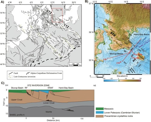
The Tornquist Zone (TZ) is one of Europe's longest and most prominent tectonic lineaments with a complex history. At the Bornholm Gat, south of Sweden, this structure is segmented into the Sorgenfrei-Tornquist Zone (STZ) to the north and the Teisseyre-Tornquist Zone (TTZ) to the south (A, B). The STZ is commonly regarded as a long-lived intraplate crustal weakness zone, along which fault reactivation occurred repeatedly throughout Paleozoic, Mesozoic and Cenozoic times (Norling & Bergström, Citation1987; Mogensen & Jensen, Citation1994; Mogensen, Citation1995; Erlström et al., Citation1997; Berthelsen, Citation1998; Bergerat et al., Citation2007). During the Late Cretaceous to Neogene, a number of NW-SE striking Mesozoic extensional grabens and pre-existing weakness zones (A) of the Southern Permian Basin experienced strong compressional reactivation and inversion pulses, e.g., the West Netherlands Basin, Lower Saxony Basin, etc. (de Jager, Citation2003; Deckers & van der Voet, Citation2018; Dielforder et al., Citation2019; Kley, Citation2018; Kley & Voigt, Citation2008; Nielsen et al., Citation2005; Ziegler, 1987, Citation1990; Ziegler et al., Citation1995). The STZ is one of such structural units located northernmost in Europe.
Figure 1. A. Regional map shows the study area and a schema of the Tornquist Zone (the STZ and the TTZ) and other NW-SE trending inverted structures in North Central Europe, truncated to the south by the Alpine-Carpathians Deformation Front. Map based on Kley & Voigt (Citation2008); Kley (Citation2018); Voigt et al. (Citation2021). BF: Broad Fourteens; BG: Bresse Graben; BM: Bohemian Massif; CG: Central Graben; DB: Danish Basin; EEC: Eastern European Craton; EG: Eger Graben; HG: Hessian grabens; LG: Limagne Graben; GG: Glückstadt Graben; PT: Polish Trough; Roer Graben; SB: Sudetic Basin; SP: Sole Pit; URG: Upper Rhine Graben. B. Topographic map with simplified structural features within the study area (compiled from Vejbæk, Citation1994; Wannäs & Flodén, Citation1994; Erlström et al., Citation1997; Erlström & Sivhed, Citation2001; Lassen & Thybo, Citation2012; Jensen et al., Citation2017; Seidel et al., Citation2018). Red lines with labels show multichannel seismic data acquired in 2016 during the cruise MSM52 with the research vessel Maria S. Merian and presented in this study. Blue lines are selected OPAB (Swedish Oil Prospecting Company) vintage industry seismic profiles. The BABEL (Baltic and Bothnian Echoes from the Lithosphere) A profile is shown with a purple line. AB: Arnager Block, AKFZ: Adler-Kamień Fault Zone, BG: Bornholm Gat, CR: Christiansø Ridge CHG: Christiansø Half Graben, CST: Colonus Shale Trough, FF: Fyledalen Fault, GF: Gat Fault, KRAF: Kullen-Ringsjön-Andrarum Fault, LiR: Linderöd Ridge, LåR: Långagrund Ridge, NäR: Nävlinge Ridge, RBG: Risebæk Graben, RF: Romeleåsen Fault, SKF: Skurup Fault, VT: Vomb Trough. C. Interpretation of the BABEL A profile. Modified after Deeks & Thomas (Citation1995), Erlström et al. (Citation1997), Thybo (Citation2000) and Meissner et al. (Citation2002). Note the crustal through-going NE dipping reflector.
The intraplate compressional inversion was interpreted as the result of the Alpine-Carpathian orogeny (Nielsen et al., Citation2005; Vejbæk & Andersen, Citation2002; Ziegler et al., Citation1995). Kley & Voigt (Citation2008) attributed the tectonism largely to far-field stress being transmitted at the beginning of the Africa-Iberia-Europe collision. The southern North Sea, including basins west of the STZ, was affected by compressional phases spanning the Late Cretaceous and Paleogene/Neogene. In central Europe, multiple inverted basins share an unconformity developed in the Campanian-Maastrichtian transition.
Spatial variations of the discrete inversion structures generated in each main compressional pulse are often observed (van der Voet et al., Citation2019; Vejbæk & Andersen, Citation1987). Fold and fault structures and the sedimentary pattern, such as strata thinning towards inverted structural highs, point to pulsating inversion activity spanning the time period from Turonian to Maastrichtian and between Eocene and Miocene (Krzywiec, Citation2006; Vejbæk & Andersen, Citation2002). Mass-transport sediments and contourites are ubiquitous deposits associated with these inversion activities, best recorded within the widespread Cretaceous-Paleogene chalk (Esmerode et al., Citation2008; Surlyk & Lykke-Andersen, Citation2007). Tectonically controlled mass-movement deposits such as debris flows, slumps, slides and turbidites, have been found, often in places along the flanks of tectonically active inverted structures, and played a substantial role in chalk redeposition (van der Molen et al., Citation2005; Back et al., Citation2011; van Buchem et al., Citation2018). Chalk sedimentation, often influenced by the inversion-induced alternating sea-floor relief, has been studied thoroughly in the Danish sector of the North Sea and the Baltic Sea west of the STZ, with particular attention paid to the abundant contouritic features, intra-chalk channels and unconformities caused by the intensification of bottom currents (Lykke-Andersen & Surlyk, Citation2004; Esmerode et al., Citation2008, Citation2007; Surlyk et al., Citation2008; Hübscher et al., Citation2019). Recognition of these depositional features in turn has had significant implications on better understanding of the tectonic and paleogeographic evolution, inversion style, as well as timing of Late Cretaceous-Cenozoic compressional events.
The BABEL A deep seismic profile (BABEL Working Group, Citation1991) revealed the crustal scale architecture across the STZ, with a thickened lower crust linked by a continuous NE dipping listric shear zone to the surface (C). Late Cretaceous inversion led to a crucial reshaping of the crustal configuration within this NW-SE elongated narrow zone. Significant up-thrusting of basement blocks occurred synchronously with subsidence in the flanking troughs, the latter consisting of both pelagic chalk and redeposited and reworked sediments (e.g., contourites, turbidites). Due to strong Paleogene-Neogene block uplift and sea-level regression, the segment of the STZ in the Bornholm-Scania area is characterized by shallow pre-Mesozoic basement, where the Upper Cretaceous-lower Paleocene (Danian) chalk deposits are only found in patches. Identification of inversion-related chalk deposits in this area has remained elusive. This location, completely unaffected by halokinetic movement, can hold key information for understanding the structural overprinting of the poly-phase compressional deformation of the area in the Late Cretaceous-Cenozoic.
In this paper, we present high-resolution multichannel seismic data acquired during the cruise MSM52 (Hübscher et al., Citation2017) in the Bornholm Gat area, an about 36 km wide strait between southwest Sweden and Bornholm island (). Our results detail tectonic and depositional patterns in the Chalk Group across the STZ, with mass-transport and contouritic deposits associated by syn-sedimentary reverse faulting. We suggest that the revealed intensified thrusting, tightening and superposition of folds evidence multiple inversion pulses. Our interpretation is consistent with a polyphase intraplate compressional deformation style during the Late Cretaceous- early Paleogene, possibly in response to the complex evolution of the North Atlantic – Alpine Tethys realm.
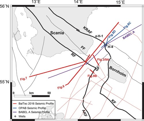
Figure 2. Survey map showing location of profiles and boreholes discussed in this paper and references to key figures.
Geological setting
The study area is located within the Bornholm Gat, the offshore area between southwest Sweden and the Danish island of Bornholm. Between the Hanö Bay Basin in the north and the Skurup Basin in the south crustal heterogeneities dominate the local structural style with a series of NW-SE elongated basement-involved structures. The main tectonic structural elements of the eastern STZ are bordered by the NW-SE trending Kullen-Ringsjön-Andrarum Fault (KRAF) in the North and the Romeleåsen Fault (RF) in the South. Here, the STZ includes the Colonus Shale Trough (CST) and the Vomb Trough (VT), both separated by the Fyledalen Fault (FF). The transition towards the TTZ is represented by the Rønne Graben (RG) (), which is limited in the west by the NE-SW trending Gat Fault (GF).
Late Paleozoic-Early Cretaceous phase
Variscan-related tectonic processes resulted in Paleozoic strata remaining in grabens such as the Rønne Graben and the Colonus Shale Trough (Erlström et al., Citation1997). Following the basement uplift a peneplain was formed in the Middle-Late Permian and this resulted in deep erosion and truncation of titled Paleozoic strata, e.g., within the Colonus Shale Trough (Norling & Bergström, Citation1987; Mogensen, Citation1995). Overlying Triassic units rest unconformably on this peneplain. Subsequently, a Middle Jurassic erosional unconformity was formed by significant exhumation, roughly coeval to the North Sea doming, induced by the Mid-Cimmerian tectonic phase (Norling & Bergström, Citation1987; Mogensen, Citation1995). The thickness of Triassic strata varies significantly in the area, increasing from 60 to 70 m near Bornholm to more than 1000 m in the Rønne Graben (Erlström et al., Citation1997). Conglomerates and coarse sandstones are preserved in the grabens, topped by widely distributed Rhaetic deposits. Shallow marine clastics were later deposited in the late Jurassic to early Cretaceous, consisting commonly of clays, mudstones and siltstones. In the Hanö Bay Basin, scattered silica cemented Rhaetian (Upper Triassic) and Jurassic sandstones occur, due to deep erosion and weathering prior to the end of the Early Cretaceous (Erlström et al., Citation1997). An increased marine influx in the Valanginian was followed by the Hauterivian-Barremian regression, with the occurrence of shale and claystone in the Barremian, as well as a depositional hiatus during the Hauterivian, Barremian and Aptian (Erlström, Citation2020; Lindström & Erlström, Citation2011).
Late Cretaceous-Cenozoic phase
The late Albian marks the onset of chalk deposition caused by worldwide sea-level rise and flooding of the Central European Basin System, spanning the Late Cretaceous-Early Paleogene (Erlström et al., Citation1997; Surlyk & Lykke-Andersen, Citation2007; Hübscher et al., Citation2019). Albian marine marlstones form a sharp transition from the underlying Jurassic and Pre-Barremian clay-dominated deposits to upper biogenic carbonates. According to the well data of Esmerode et al. (Citation2007), the limestone-dominated Cenomanian and Turonian are divided by a thin layer of calcareous shale. In the Coniacian limestone, flint and marlstone diminish upwards. The Santonian to lower Maastrichtian is composed of interbedded limestone and marl, whilst soft chalk dominates the upper Maastrichtian. Flint is again present in the upper Maastrichtian and Danian limestone, corresponding to poor reflectivity in seismic data. The NW-SE elongated Vomb Trough consists of a dominating interval of clastic and calcareous Upper Cretaceous strata belonging to the Vomb Formation, overlying the Arnager Greensand, Vitabäck Clays and Fyledal Clay of Upper Jurassic-Lower Cretaceous age (see Fig. 24.11 in Erlström, Citation2020). Up to 600 m of Santonian-Campanian infill is preserved and outcrop within this segment in the Scania area (Erlström & Guy-Ohlson, Citation1994; Lindström & Erlström, Citation2011). Maastrichtian remnants are present in its southeasternmost part (Christensen, Citation1984).
A major regional stress field change is generally assumed to have started in the Late Cretaceous, changing from extension to compression in response to the Africa–Iberia–Europe convergence (Ziegler, Citation1990; Kley & Voigt, Citation2008; Kley, Citation2018). Compression and shortening resulted in uplift of formerly extensional basins with inversion axes located mostly along the former depocenters, while the new depocenters were shifted towards marginal troughs filled with thick chalk deposits. Ceasing of this contraction is evidenced by burial of little-deformed Maastrichtian-Early Paleogene units in large basin areas and succeeded by a milder compression in the early Cenozoic (Kley & Voigt, Citation2008). Numerous observations from the intraplate inversion structures suggest strong compression having lasted into the late Maastrichtian and Danian (Vejbæk & Andersen, Citation1987, 2002; Krzywiec, Citation2006; van der Voet et al., Citation2019;). The Danish Basin southwest of the STZ documents a diminishing of the compression as a result of plate-wide stress relaxation since the middle Paleocene, and this phase, commonly referred to as Laramide inversion, is characterized by a broad doming uplift (Nielsen et al., Citation2005). According to Kley (Citation2018), the mechanism behind the Laramide uplift is not fully understood so far and unique inverted structures linked unequivocally to this event are missing, whereas two further inversion pulses are documented between the Eocene and Miocene in Western Europe, summarized as the Pyrenean/Savian phase. These last inversion pulses are characterized by N-S compression, as observed from the western Netherlands to Britain (Kley, Citation2018 & references within). In Neogene times, significant uplift occurred in southern Sweden, and consequent erosion of much of the chalk cover across the STZ, with its entire removal to the northeast (Japsen et al., Citation2002). The Alnarp Valley, a graben-like structure running parallel to the Romeleåsen Fault, but southwest of it, is filled at the top by some tens of meters of glacial deposits (Anjar et al., Citation2014), and is assumed to be related to possible late tectonics in the Quaternary along the inherited Alnarp Graben Fault (Norling & Bergström, Citation1987; Hübscher et al., Citation2019).
Data and methods
The multi-channel seismic data were acquired in 2016 during the BalTec cruise MSM52 of the research vessel Maria S. Merian using a 2700 m long streamer with an 8 unit air gun source array having a total volume of 1200 cubic inches. The GI-gun type source used was towed at 3 m depth and was activated every 25 m. The streamer was towed at 4 m depth and had a channel spacing of 12.5 m. The nearest hydrophone was located 33 m from the source to allow shallow subsurface imaging. The source array was tuned to enhance high frequencies for high-resolution imaging. The complete acquisition details are described by Hübscher et al. (Citation2017).
Processing of the seismic data included steps such as swell noise attenuation, designature, surface-related multiple elimination (SRME), tau-p deconvolution and post-stack migration. An aggressive outer mute was applied to the shot gathers, which removed mostly to-be-stacked-in noise and sacrificed only a small part of the useful far-offset reflections. The removed redundant parts of the shot gathers contain abundant information on refractions with dense recording and long offsets. We used this information to derive high-resolution travel-time tomographic velocity models along those profiles with small acquisition curvature and feathering angles.
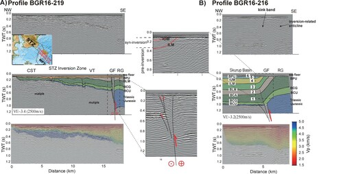
We used the PStomo_eq code (Tryggvason et al., Citation2002) to perform the inversions. The forward problem is solved using a finite difference scheme applied to the Eikonal equation in three dimensions (Podvin & Lecomte, Citation1991; Hole & Zelt, Citation1995) within the code. The conjugate gradient LSQR algorithm (Paige & Saunders, Citation1982) is then employed to update the velocity model iteratively. A range of 2D models were generated by varying the velocity gradient of the bedrock layer. Based on testing, we observed that the depth of the rays sampled was largely dependent on the starting model. We chose coarser 2D models that fitted best the basin geometry as defined by the reflection data (A; profile BGR16-219) for defining a preferred starting model (B) with a positive gradient for the final inversion run. A representative final model (C) was obtained by decreasing the damping factor during the iterations, with the travel-time RMS residuals decreasing from 75.9 × 10⁻³ to 7.4 × 10⁻³ s. D illustrates the ray coverage along the profile as a guide for evaluating the reliability of the final model. The higher this value, the denser is the ray coverage and the more reliable is the result in the final model.
Figure 3. Traveltime tomographic results of Profile BGR16-219, A. migrated multichannel seismic image, B. preferred starting model, C. final model, D. ray coverage. CST: Colonus Shale Trough, GF: Gat Fault, VT: Vomb Trough. VE: vertical exaggeration, calculated assuming a constant velocity of 2500 m/s.
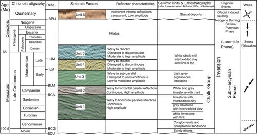
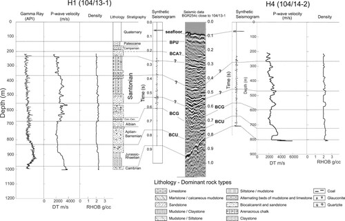
The 2D seismic profiles used in this study are located in the Swedish territory of the Bornholm Gat region, with generally northeast-southwest and northwest-southeast trends. We present four profiles from the BalTec cruise MSM52 and two additional vintage OPAB (Swedish Oil Prospecting Company) profiles. The longest profile BGR-254c is transverse to the STZ with a length of ∼120 km. The Post-Permian seismo-stratigraphy framework in this study is based on Erlström et al. (Citation1997), Sopher et al. (Citation2016) and Al Hseinat & Hübscher (Citation2017). We traced prominent horizons including the base Cretaceous Unconformity (BCU), the base Chalk Group BCG and the glacially eroded base Pleistocene Unconformity (BPU). The identification of the Chalk Group is adopted from previous studies in adjacent areas of the Danish Basin (Esmerode et al., Citation2007; Hübscher et al., Citation2019; Lykke-Andersen & Surlyk, Citation2004), with six major horizons; the base Campanian (BCA), the base late Maastrichtian (BLM), the internal lower Maastrichtian (ILM) and the internal upper Maastrichtian (IUM) (). Based on seismic facies, reflector continuity and bounded unconformities, the high-resolution seismic profiles allow us to map the well-defined Upper Cretaceous horizons for the entire study area. The Chalk Group has been sub-divided into five seismic units between the BCG and the BPU (). Deposits of Turonian-Santonian age make up Unit 1, the Campanian Unit 2 and the Maastrichtian-Danian is classified into units from Unit 3 to Unit 5. In the Hanö Bay Basin, precise well-ties were hampered by low-quality synthetic seismic sections due to borehole washout and large spacing between the seismic profiles. The sonic and density logs, as well as lithological information, from the exploration wells H-1 and H-4 provide additional stratigraphic constrains for the sandy intervals adjacent to the STZ (). Above the prominent seismic marker of the Top Cambrian, the BCG can be recognized by a distinct upward increase in sonic velocity, which corresponds to a transition in the seismic data from a lower less reflective portion to an upper more reflective portion. The age assignment of Santonian intra-chalk horizons can only be made tentatively.
Figure 4. Seismic stratigraphic subdivision of the Chalk Group and main reflection markers used for stratigraphic interpretation within the study area (after Lykke-Andersen & Surlyk, Citation2004; Esmerode et al., Citation2007; Hübscher et al., Citation2019). The tectonic events and stress field orientation are based on previous publications (Bergerat et al., Citation2007; Kley & Voigt, Citation2008; Kley, Citation2018; Seidel et al., Citation2018). BCU: base Cretaceous Unconformity; BCG: base Chalk Group; BCA: base Campanian; BLM: base lower Maastrichtian; ILM: internal lower Maastrichtian; IUM: internal upper Maastrichtian; BPU: base Pleistocene Unconformity;
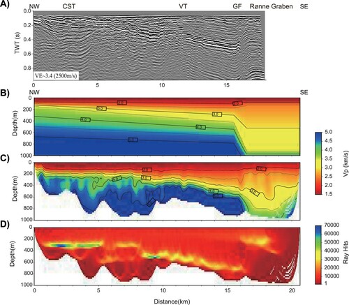
Figure 5. Borehole-log and lithology information (based on Kumpas (Citation1980) and Sopher et al. (Citation2016)) from exploration wells H1 and H4 located in the Hanö Bay Basin. Well-tie was made using synthetic seismograms to the profile BGR254c.
Observations
Seismo-stratigraphy
Lower Cretaceous and Seismic Unit 1.
In general, the sedimentary strata above the Base Cretaceous Unconformity (BCU) are well-stratified. The Lower Cretaceous, only some tens of ms two-way-traveltime (TWT) thick, underlies a region-wide defined Base Chalk reflector. The overlying Unit 1, bounded at its base by the base Chalk group (BCG) and at its top by the base Campanian (BCA), is composed of even, parallel and, in places, wavy reflections showing strong reflectivity and good continuity (). In the Skurup Basin, Unit 1 shows a subtle thickness increase of internal strata towards the Romeleåsen Fault with prominent drag folding ( and ). Although separated by the Romeleåsen Ridge, this unit is present in the Vomb Trough, exhibiting sub-parallel reflections of similar lateral continuity and high amplitude (). The Vomb Trough reveals strong internal folding and reverse faulting (). Adjacent to the Kullen-Ringsjön-Andrarum Fault in the Hanö Bay Basin, where wells indicate 500 m thick calcarenite and sandstone, Unit 1 displays a wedge-shaped, with chaotic seismic facies, complex internal geometry (). Sopher et al. (Citation2016) identified clinoforms within this sub-unit, which are clearly revealed on our data, downlapping basinwards on marine fine-grained strata (). In this basin, Unit 1 thickens markedly towards the STZ, assumed to be due to syn-sedimentary inversion tectonics.
Figure 6. A. Migrated MSC Profile BGR16-254. Bathymetric seafloor is drawn in black on top of the profile, complementing the uppermost unimaged portion. B. Interpreted MSC profile BGR16-254 showing the shallow architecture of the Skurup Basin, the STZ and the Hanö Bay Basin. The central STZ inversion zone is characterized by an up-thrusted basement block. Red arrows indicate the fault kinematics in the Late Cretaceous-Paleocene inversion. C. Migrated MSC Profile BGR16-254 with superimposed velocity model. CST: Colonus Shale Trough, FF: Fyledalen Fault, KRAF: Kullen-Ringsjön-Andrarum Fault, RF: Romeleåsen Fault, VT: Vomb Trough. Location is shown in and by labeled red line. VE: vertical exaggeration, calculated assuming a constant velocity of 2500 m/s.
Figure 7. A. Migrated MSC Profile BGR16-220. Bathymetric seafloor is drawn in black on top of the profile, complementing the uppermost unimaged portion. B. Interpreted MSC profile BGR16-220 showing the shallow architecture of the transition from the Skurup Basin to the TZ across the Romeleåsen Fault, and a close-up of the Vomb Trough (right). Red arrows indicate the fault kinematics in the Late Cretaceous-Paleocene inversion. C. Shot gather recorded across the FF. Note the significant variation of the apparent velocity of the refractions. The horizontal axis is offset distance from source to receiver; vertical axis is two-way traveltime reduced at 4 km/s. AGC and a bandpass filter were applied to enhance the first-arrival amplitudes. D. Part of the migrated MSC Profile BGR16-254 () with velocity model superimposed shows the shallow architecture of the Vomb Trough within the inverted STZ. Note the low velocity (1900–2500 m/s) in the Vomb Trough and the strata thinning towards the STZ in the Maastrichtian-Danian interval, truncated at the top by BPU. FF: Fyledalen Fault, KRAF: Kullen-Ringsjön-Andrarum Fault, RF: Romeleåsen Fault, VT: Vomb Trough. Location is shown in and by labeled red line. VE: vertical exaggeration, calculated assuming a constant velocity of 2500 m/s.
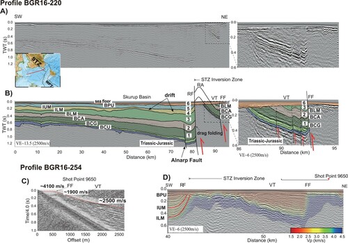
Figure 8. A. Migrated MSC Profile BGR16-254. Bathymetric seafloor is drawn in black on top of the profile, complementing the uppermost unimaged portion. B. Interpreted MSC profile BGR16-254 showing the shallow architecture of the STZ and the Hanö Bay Basin. OPAB seismic profile D72-29 (C) and NA79-168 (D) show the shallow architecture of the transition from the inverted STZ to the Hanö Bay Basin across the KRAF. Arrows indicate the fault kinematics in the Late Cretaceous inversion. BCA: base Campanian. KRAF: Kullen-Ringsjön-Andrarum Fault. Location is shown in and by labeled red and blue lines. VE: vertical exaggeration, calculated assuming a constant velocity of 2500 m/s.
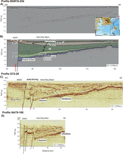
Figure 9. MSC Profile BGR16-216 (A) and Profile BGR16-219 (B) show shallow architecture of the transition from the Rønne Graben to the STZ and the Skurup Basin across the Gat Fault. Note the strata thinning in the uppermost Maastrichtian interval. Bathymetric seafloor is drawn in black on top of the profile. Location is shown in and by labeled red line. VE: vertical exaggeration, calculated assuming a constant velocity of 2500 m/s.
Seismic Unit 2.
Unit 2 comprises marly chalk of Campanian age, bounded conformably at its base by the BCA and at the top by the base lower Maastrichtian (BLM) or is truncated by Quaternary deposits. The sub-parallel and continuous internal reflections have similar strong reflection strength as those of Unit 1 ( and ) that gradually decreases upwards. Towards the Alnarp Valley, where there is a subtle increase of the unit thickness ( and ), the reflection amplitude weakens significantly. At this location, adjacent to the inverted STZ, sandstone interbeds are found within this unit, e.g., the Lund Sandstone (Erlström et al., Citation1997). The top of the Campanian, recognized as an unconformity in the area offshore Stevns Klint (Esmerode et al., Citation2007), is also evidenced in our data, revealing an erosional truncation of the Campanian. In the Hanö Bay Basin, Unit 2 represents a pronounced landward-directed transgressive interval by progressively onlapping the northward-prograding clinoform in Unit 1 (B, Profile km 91-96). Further landward, this unit shows a clinoform, assumed to be associated with shelf retrogradation (B, Profile km 85-92).
Seismic Unit 3-Unit 5.
The interval of Units 3–5 consists of thick Maastrichtian-Danian white chalk. Among the faulted blocks in the study area, it is best persevered at the SW flank of the inverted STZ in the Skurup Basin ( and ). Unit 3 is incomplete only in the uppermost part of the Vomb Trough and the Hanö Bay Basin. In contrast to the underlying Unit 1 and Unit 2, Units 3–5 show an irregular reflection pattern with poor reflectivity, particularly in their upper parts, partly due to the data quality with a severe contamination of sea floor multiples. However, abundant mounded and hummocky reflections are observed in the entire interval. The stratigraphic boundaries in this interval, defined by Lykke-Andersen & Surlyk (Citation2004), have been inferred in this study by somewhat ambiguous reflection terminations such as downlaps, onlaps and truncations. The top Campanian unconformity (base Unit 3) appears as an erosional surface, which is tilted and dipping towards the inverted STZ. The overlying Unit 3 exhibits an uneven thickness distribution and wavy and irregular internal reflections. Previous studies indicated mounded or eroded depositional features in the form of ridges and valleys (Lykke-Andersen & Surlyk, Citation2004; Hübscher et al., Citation2019), which are also found here in places and are most pronounced in this unit. At about 20 km SW of the inverted STZ, Unit 3 exhibits a prominent convex-upwards nature ( and ), thought to be the mounded contourite drift developed adjacent to the inverted STZ by a strong contour current in the Maastrichtian, with a moat formed in between (Surlyk & Lykke-Andersen, Citation2007; Hübscher et al., Citation2019). Among all the stratigraphic boundaries, the ILM displays the most uneven relief, which is compensated by infills of Unit 4 ( and ). Unit 4 and also Unit 5 show chaotic seismic facies adjacent to the inverted STZ, reflections being irregular and wavy with rather poor reflectivity and continuity. Unit 4 consists mostly of moat fill and on the SW-side of the moat shows a mounded drift of smaller width than the drift in Unit 3 at about 10 km SW of the STZ (). Within the moat fill, lower Maastrichtian Hansa Sandstone is present (Erlström et al., Citation1997; Erlström, Citation2020). At the Romeleåsen Fault, intense drag folding is observed in Units 3–5 and is limited at the top by the BPU.
Seismic Unit 6.
Unit 6 contains the Quaternary sediments and truncates the underlying chalk successions, and in places it rests directly on the pre-Mesozoic basement, e.g., above the Colonus Shale Trough ( and ). This unit is generally thin, but with a slight increase of thickness where incised valleys are present.
Fault systems
The inverted STZ reveals prominent strata truncation against steep faults, i.e., the Romeleåsen Fault and the Kullen-Ringsjön-Andrarum Fault ( and ). The major faults, including the steep Fyledalen Fault, are basement-involved and dip towards the central inverted area. Strong reverse faulting is evidenced by drag folding of the chalk strata ( and ). There is no clear evidence that the major faults extend upwards into the Quaternary sediments and seafloor. However, the Fyledalen Fault and Kullen-Ringsjön-Andrarum Fault might have been reactivated ( and ).
In the proximal area to the SW boundary of the STZ, the Alnarp Fault delimiting the southwest border of the Alnarp Valley shows a normal offset in successions below Unit 2 (). The reverse movement along the Romeleåsen Fault caused drag folding of the Mesozoic successions. Therefore, the Romeleåsen Fault dips towards NE and borders an antithetic structure. The relief of down-warping gradually diminishes upwards into the Internal Lower Maastrichtian (ILM). Above it is not pronounced. The NE-dipping strata in the Vomb Trough are terminated by the Fyledalen Fault to the northeast. The Hanö Bay Basin terminates against the Kullen-Ringsjön-Andrarum Fault, northeast of the STZ, and is characterized by a southwest-dipping trough that developed due to basement-involved faulting ( and ). Below a thin layer of Cenozoic deposits, the successions range from the Upper Triassic to Upper Cretaceous, with interbedded sandstone adjacent to the Kullen-Ringsjön-Andrarum Fault being present. Fault splays are found to be basement-involved in a reverse sense of motion and may have formed as the shortcut splays of the main Kullen-Ringsjön-Andrarum Fault in a transpressional regime (). There is no evidence that a main listric fault is present dipping towards the northeast as interpreted from the BABEL profile (C).
The Gat Fault, formed as a normal fault during the opening of the Rønne Graben as early as the Triassic (Deeks & Thomas, Citation1995), exhibits a strong reverse reactivation (). The basement of the graben lies out of range of our images. However, the Mesozoic to Cenozoic successions within the graben show inversion-related anticlines at its northwestern border (). Overlying the main fault, the Chalk succession reveals an inversion-related kink band (E). Pronounced strata thinning towards the inverted graben, which indicates syn-inversion, occurs only within Units 4 and 5 (B).
Interpretation and discussion
Velocity structure
The overall near-surface architecture shows good correlation between the MCS sections and tomographic models, in particular, for the sediment-basement contact (, and ). We consider the top of the pre-Mesozoic basement to coincide with the iso-velocity contour at 3.5–4 km/s. In places where the Paleozoic is absent, it consists of, crystalline Precambrian rocks and compares favorably with the velocity measurements from wells in the Hanö Bay (Kumpas, Citation1980), recent refraction tomographic analysis by Ahlrichs et al. (Citation2021) and migration velocity analysis by Schnabel et al. (Citation2021). The high velocity of the Paleozoic rocks (e.g., the Colonus Shale) in southeast Scania has a similar range as the Precambrian rocks (Wannäs & Flodén, Citation1994). The low-velocity sedimentary successions (1.5–3.5 km/s; red, yellow and green colored; ) comprise Mesozoic to Quaternary sedimentary deposits, mainly the chalk succession, which is also consistent to findings by Ahlrichs et al. (Citation2021) and Schnabel et al. (Citation2021).
On profile BGR16-254 (), the pre-Mesozoic basement of the central inverted STZ is characterized by high velocities, which sharply contrast with low velocities in the flanking sedimentary basins (the Skurup Basin and the Hanö Bay Basin). Prominent truncation of beddings on the reflection seismic data at the boundary faults (the Romeleåsen Fault and the Kullen-Ringsjön-Andrarum Fault) coincides with sharp velocity variation. Within the central STZ, drastic tilting of the strata characterizes the Vomb Trough, truncated by thin Quaternary sediments at the top and by the Fyledalen Fault to the NE (B). The Vomb Trough exhibits a less than 10 km wide graben-like structure with anomalously low velocities (1.5–2.5 km/s, ). This velocity is lower than that in the STZ-flanking basins (approximately 2.5–3 km/s; ), but similar to those in the south-western Baltic Sea (Hansen et al., Citation2007). Nielsen et al. (Citation2011) reported a depth-dependent layering chalk velocity in the east Danish Basin, ranging from 2.4 to 4.3 km/s. Consistent with their model, our result also shows the chalk velocity is controlled primarily by the burial depth. The overall high chalk velocity was attributed to the presence of clay in the region, with associated increased pressure dissolution and cementation (Nielsen et al., Citation2011). The H1&H4 wells located in the flank of the tectonically active STZ do not serve as a direct comparison for the clay content. Anomalously high chalk velocity (∼ 4 km/s) was thought related to ∼500 m of paleo-burial (Nielsen et al., Citation2011), which is not evident in our model. Instead, the anomalously low velocity in the Vomb Trough illustrates an opposite trend, perhaps generated during the STZ exhumation.
By contrast, the Colonus Shale Trough is characterized by high velocity (>4 km/s) and the interior structure is poorly imaged with only vague NE-dipping reflections, which are indicative of the Upper Silurian strata according to Erlström et al. (Citation1997). The NW-SE trending profiles BGR16-219 and BGR16-216 map the transitions from the inverted Rønne Graben into the Skurup Basin and the inverted STZ, respectively (, see also ). The top of the Pre-Mesozoic basement within the inverted STZ is well depicted by velocity higher than 4 km/s. Janik et al. (Citation2022) calculated 5.8 km/s for the Upper Paleozoic strata south-east of Bornholm. Notable lateral velocity variation characterizes the Gat Fault. Truncated by the Quaternary sediments at the top, the low-velocity Mesozoic sequences in the Vomb Trough thin towards the NW and are absent over the Colonus Shale Trough (A).
The SW flank of the STZ
In southern Sweden, the Lower Cretaceous layer has a reduced thickness of just a few meters (Lindström & Erlström, Citation2011). The thin Lower Cretaceous to Cenomanian successions include the Arnager Greensand Formation above the Rhaetian-Jurassic sandy to muddy siliciclastics of the Höganäs, Rya and Annero Formations (Norling & Bergström, Citation1987; Ahlberg et al., Citation2003; Sopher et al., Citation2016). The sedimentary succession of the Chalk Group (Units 1–5) is over 1000 meters thick within the Skurup Basin ( and ). Our observations suggest that the BLM unconformity is the dominant stratigraphic boundary separating the chalk sequences of distinct facies. The underlying Units 1–2 consist of the Turonian-Campanian chalk successions, that were thought to have been deposited in relatively quiet pelagic conditions as they are represented by a sub-horizontal reflection pattern. Their recent northeast tilt indicates later faulting during the inversion phases. The deposition of the overlying Maastrichtian-Danian chalk successions (Units 3–5) occurred in a more energetic depositional environment. The succession represents a lower Maastrichtian aggradational drift, which is around 20 km wide with relief up to 180 m (assuming an average velocity of 2.5 km/s). It formed as part of a contourite-moat system that emerged along the southwest escarpment of the inverted STZ (Surlyk & Lykke-Andersen, Citation2007; Hübscher et al., Citation2019), with the strongest contour current occurring in the Maastrichtian. In our profiles, the inverted STZ reveals strong up-thrusting at the Romeleåsen Fault, with drag folding evidenced in almost the entire chalk successions ( and ). The vertical displacement of the basement-cover interface exceeds 1–1.5 km (assuming an average velocity of 2–3 km/s). Thinning of syn-tectonic strata towards the inverted STZ is identified in the uppermost Maastrichtian-Danian successions (ILM, IUM; Units 4–5, C), which are directly truncated by the overlying Quaternary sediments (BPU; Unit 6). This suggests that this strong inversion persisted or intensified even into the late/post Maastrichtian.
The tilting and internal folding of the strata in the Vomb Trough indicates an eroded southwest-verging anticline over the Romeleåsen Fault that was subjected to strong compression during the inversion episode. We name the anticline the Romeleåsen Anticline. Numerous steep reverse faults characterize the backlimb of this anticline (B). Given that the major sedimentary intervals (Units 1–2) are coeval with the previously supposed primary inversion pulse of Santonian-Campanian ages (Norling & Bergström, Citation1987; Erlström et al., Citation1997), the Vomb Trough was thought to display a syn-sedimentary nature of the chalk (B). However, evidence for syn-inversion deposition, e.g., strata thinning and progressive onlapping, can be found neither towards the Romeleåsen Fault nor towards the Fyledalen Fault. On the contrary, the Vomb Trough shows little variability of the overall internal strata thicknesses (B). These observations are consistent with the widespread deposition of the Upper Cretaceous chalk successions, at least Units 1–3, across the SW flank of the STZ. Subsequent strong contractional fault reactivation occurred no earlier than in the Maastrichtian. The fractures developed by shortening either during the folding of the anticline or in post-folding tightening (Tavani et al., Citation2015). The resultant enhancement of porosity and reduction of bulk rock density can thus explain the extremely low velocity that is observed only in the Vomb Trough, but not in the flanking basins, where Units 1–2 should not vary significantly laterally in lithology, but were better cemented and compacted by the burial. We suggest that the truncation of the pre-existing chalk interval of the Romeleåsen Anticline ( and ) cannot be the result of the intense Late CretaceousPaleocene inversion itself, but rather should be attributed to the subsequent Late Paleogene regression (e.g., Michelsen & Nielsen, Citation1993; Erlström et al., Citation1997) and related to the uplift of the South Swedish Dome in the Neogene (Japsen et al., Citation2002). Further southeast, several tens of km from the area of Neogene doming, an analogous southwest-verging anticline has been observed east of the Adler-Kamień Fault Zone (AKFZ), (Schlüter et al., Citation1997; Al Hseinat & Hübscher, Citation2017, their Fig. 16). The Upper Cretaceous chalk of fairly uniform thickness attests to the formerly widespread and relatively horizontally deposited pre-Maastrichtian chalk, which was deformed subsequently by strong inversion tectonics at a rather late stage in the Late Cretaceous.
The NE flank of the STZ
The crystalline basement surface in the Hanö Bay Basin of the NE flank of the STZ shows irregular topography, which is smoothed by Rhaetian-Jurassic sandstones (Sopher et al., Citation2016, ). The continuous deposition of Unit 1 and Unit 2 represents the primary transgressive successions in the early Late Cretaceous. Towards the inverted STZ, a facies transition from Turonian-Campanian fine-grained marine chalk (B, Profile km 97-120) to mostly clastic terrestrial coarse-grained sands and calcarenites (Sopher et al., Citation2016) is marked by the northeast prograding clinoforms (B, Profile km 85-97). Adjacent to the uplifted STZ, there is a dominating thick (c. 800 m) package of sandstone of mainly Cenomanian-Campanian age, and a Cenomanian-Coniacian sandy limestone interval (Sopher et al., Citation2016). The chaotic seismic facies and the internal geometry suggest a depositional complexity, where in particular, turbiditic and mass transport deposits were induced by periodic erosion and block uplifting within the STZ. They are revealed on our data as vertically stacked clinoforms down-lapping basinwards onto the marine fine-grained strata (). Unit 1 appears as a mounded depositional body indicating the formation of a contourite drift by significant along-slope sedimentation. Strata thinning towards the fold crest over the thrust splays indicate syn-sedimentary primary basin infills of Santonian-Campanian ages (). The reverse reactivation of the Kullen-Ringsjön-Andrarum Fault was found to have ceased in the Campanian (Norling & Bergström, Citation1987), and quiet tectonic conditions returned in the region after the main transgression in the early Campanian (Surlyk & Sørensen, Citation2010).
Nielsen & Hansen (Citation2000) explained the increase of accommodation space in the marginal trough during the compressional phase by inversion-induced flexural subsidence. This was accompanied by an eustatic sea-level rise in the Santonian-Campanian (Haq et al., Citation1987), resulting in the burial of turbiditic and mass transport deposits (). The overall NE prograding pattern of the syn-inversion deposits, outside of the inverted and eroded STZ, supports the syn-compressional subsidence model and is consistent with the northeast margin of the Mid-Polish Anticlinorium (Krzywiec, Citation2002; Krzywiec et al., Citation2003, Citation2018). The previously interpreted NE-dipping listric Kullen-Ringsjön-Andrarum Fault based on the BABEL profile indicates an opening of the Hanö Bay Basin as an extensional half graben prior to the later compressional inversion (Sopher et al., Citation2016). However, we interpret the Kullen-Ringsjön-Andrarum Fault as a splay of SW dipping reverse faults, showing no evidence for a Hanö Bay Basin half-graben structure. Instead, the Hanö Bay Basin is spatially and temporally analogous to numerous other intraplate narrow marginal troughs in central Europe, with a depocentre formed directly adjacent to the uplift edge resembling a classic foreland basin due to flexure with tilting of broken rigid lithosphere (Hindle & Kley, Citation2021).
The transition between the STZ and the RG
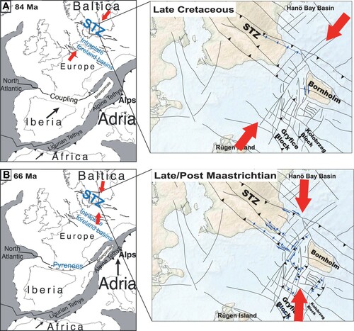
The Gat Fault delimits the south end of the STZ and has been previously interpreted as a lateral ramp between the Romeleåsen Fault and the Adler-Kamień Fault Zone (Berthelsen, Citation1998). Regional reactivation of the northeast trending faults, which link the major northwest trending structures, were in a state of transpression during the Late Cretaceous inversion (Kley & Voigt, Citation2008). The Gat Fault exhibits a positive flower structure in 2D view (B). Results from single-channel seismic surveys document a sinistral strike-slip nature along these northeast striking faults in the Bornholm Gat area (Wannäs & Flodén, Citation1994). The related right-lateral strike-slip on the northwest striking STZ-oriented faults (Deeks & Thomas, Citation1995; Krzywiec et al., Citation2003; Mogensen, Citation1995) indicates a conjugate strike-slip fault pattern in the Late Cretaceous-Paleocene (Sub-Hercynian), which has been documented by the fault-slip data onshore Scania to have occurred at around the Danian (Bergerat et al., Citation2007).
Reverse reactivation of the Gat Fault also supports the creation of northwest-verging shortcut faults towards the Vomb Trough, i.e., towards the backlimb of the Romeleåsen Anticline (B). This suggests a superposition of inversion-related northeast trending folds onto the northwest trending folds (e.g., Romeleåsen Anticline), consistent with the general orthogonal fold pattern within the Rønne Graben (Graversen, Citation2004). Based on the observed inversion-related kink band, the syn-inversion interval (Units 4–5) can be inferred by the thinning towards the inverted Rønne Graben, with the base of syn-inversion tentatively interpreted as the ILM (B). Vejbæk & Andersen (Citation2002) suggested inversion pulses of Campanian and Maastrichtian age in the Bornholm area from a similar inversion structure over the NW-SE reverse fault bounding the Rønne Graben. Hence, together with the results presented here, the Maastrichtian phase revealed at the northwestern and northeastern trending faults bounding the Rønne Graben experienced oblique inversion at this stage. Deeks & Thomas (Citation1995) suggested a modification of graben-bounding faults resulted from transpressional deformation during a later inversion phase. This likely applies to most of the graben-bounding faults in this area, including the ones trending NE-SW.
Tectono-sedimentary evolution and timing of inversion
Our results indicate that the STZ is characterized by a central up-thrusted basement block flanked by syn-tectonic marginal troughs. The asymmetry of the marginal troughs was suggested to have resulted from an asymmetric shear zone connecting the inverted crust to the upper mantle below the northeast Fennoscandian Shield (Hansen et al., Citation2000; Nielsen & Hansen, Citation2000). This lithospheric shear zone has been interpreted as dipping northeast in a listric form in numerous studies, with unclear timing for activation (C) (Liboriussen et al., Citation1987; BABEL Working Group, Citation1991; Deeks & Thomas, Citation1995; Erlström et al., Citation1997; Thybo, Citation1997; Berthelsen, Citation1998;). The seismic profiles and interpretation presented in this paper suggest that the reverse reactivation of its shallow expression, the Romeleåsen Fault, was from Campanian and most intense in the Maastrichtian and younger times.
A illustrates the asymmetric uplift of the STZ associated with a schematic reconstruction of the chalk deposition. There are primarily two main inversion pulses that can be inferred based on our observations. The early pulse commenced in the Turonian and culminated in the Santonian-Campanian, commonly accepted as a primary inversion pulse during the Sub-Hercynian phase. During this period, the northeast flank underwent significant up-thrusting. The NW-SE elongated Linderödåsen Ridge emerged above sea level (Surlyk & Sørensen, Citation2010), when numerous tectonically formed anticlinal ridges and resulting islands developed in the Chalk Sea.
Figure 10. A. Schematic reconstruction of the chalk-related tectono-sedimentary evolution across the STZ in the Bornholm Gat area. B. Cross-section from the Harz mountains to the STZ (modified from Kley & Voigt (Citation2008)) showing crustal configuration of the intraplate foreland basins and the STZ. Note the updated geometry and kinematic of the Late Cretaceous inversion in the STZ from this work.
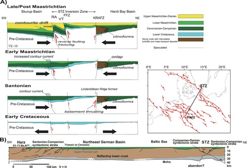
In contrast, the southwest flank manifests the widespread deposition of the chalk successions in relatively quiet tectonic conditions, with the uplift of the Romeleåsen Ridge being relatively small and emerging intermittently above sea level since the Campanian. The continuous Units 1–2 thin towards the Linderödåsen Ridge. A stronger reverse fault reactivation is evidenced in the second main inversion pulse by folding and breaching of the widespread chalk successions at the southwest flank of the Skurup Basin. Fold tightening revealed in the Vomb Trough confirms this intense compressional shortening with significant fracturing of the chalk strata. The uplift of the Romeleåsen Ridge controlled the development of the marked contourite-moat system by interacting with a north-west directed bottom contour current. This was most pronounced in the Maastrichtian. The depth of the moat in the Kattegat area, created by the same bottom current flow, is interpreted to have reached a maximum of 180 m (Surlyk & Lykke-Andersen, Citation2007) before the final infill in the late Maastrichtian. In the Scania-Bornholm area, the moat has even greater relief and is thought to also have been in interaction with fault activity along the Alnarp Valley Fault (Hübscher et al., Citation2019). The data in this study document its growth faulting and demonstrate clear syn-tectonic deposits of synclinal Units 2–5 beneath the Alnarp Valley. The BLM acts as a predominant erosional unconformity separating the formerly horizontally deposited Unit 1–2 from the overlying thick trough infills of Units 3–5.
Hübscher et al. (Citation2019) stressed the primary cause of the chaotic internal reflection pattern as a result of the STZ-bounded turbulent currents. Moreover, the strength of tectonic faulting has a great influence on the dimension of the moat. Here, we suggest the seismic facies also reflect a process of significant tectonically induced sediment transport and reworking. The drift-moat in Units 4–5 indicates an intense contour bottom current, likely related to the minor regression in the latest Cretaceous, along the tectonically active steep slope. The moat infill consists predominantly of deposits from down-slope processes, e.g., turbidity currents, debris flows or slumping. The main pulses of the redeposition of clastic sediments at this flank have been observed in the Campanian and Maastrichtian (Erlström et al., Citation1997). We propose that throughout the episodes of compressional inversion, the submarine redeposited and reworked chalk was abundant at the uplifted area, largely controlled by local events of intensification of faulting and slope instability. The deposits derived from gravity-driven processes are superimposed on the long-lasting contourite system. Thus, allochthonous chalk overlies or is embedded in autochthonous (pelagic) chalk.
However, there are differences in the timing of the main inversion pulses on discrete structures (Vejbæk & Andersen, Citation1987, Citation2002; van der Voet et al., Citation2019). The second main pulse corresponds likely to the identified late/post Maastrichtian inversion pulse in the MPT (Krzywiec & Stachowska, Citation2016) and Danish Central Graben (Vejbæk & Andersen, Citation2002; van der Voet et al., Citation2019). Accordingly, the Late Cretaceous-Paleocene tectono-sedimentary evolution of the STZ partly contrasts with previous local constraints of inversion timing with a decreased fault activity in the Maastrichtian (Liboriussen et al., Citation1987; Erlström, Citation2020), and is different from those in large areas of the adjacent southwestern SPB where it is suggested that little deformed Maastrichtian-Paleocene deposits sealed the formerly compressional structures (Kley & Voigt, Citation2008; Kley, Citation2018). According to Japsen et al. (Citation2002), the present-day missing Chalk deposits of nearly 1 km in our study area is primarily a result of the Cenozoic rise of the South Swedish Dome, and hence the widespread Upper Cretaceous-lower Paleogene (Danian) chalk corresponds well to the maximal burial of the Mesozoic successions prior to Paleogene-Neogene erosion. Our data and interpretation provide additional insight supporting the conclusion of Japsen et al. (Citation2002) by showing a subtle inversion-caused erosion, which probably only removed the chalk over the crestal part of the inversion-related folds and did not lead to the complete absence of Units 4–5 over the STZ and the Hanö Bay. The missing sequences lead to poorly constrained timing of the younger inversion pulse. However, to explain the asymmetry of the marginal trough related to the crustal shear zone, the differential reactivation of discrete structures should also be taken into account. The northeastern flank of the inverted Harz mountains, is characterized by multiple southward-dipping listric faults and northward-shallowing basins, e.g., the Subhercynian Basin. The latter share the common characteristics of inversion-related intraplate foreland basins (B). Based on our observations, an updated configuration of the STZ shows a similar geometry at its north flank, with syn-tectonic deposits from the same period of the Santonian-Campanian constituting the trough infills. Basement thrusting and subsidence, as early as Turonian, may likewise have initiated along a pre-existing crustal weakness zone at this locality of the distal intraplate foreland during the Sub-Hercynian phase. This seems to have been followed by cessation of south-dipping thrusting, since a north-dipping thrust is recognized to dominate in the STZ (BABEL Working Group, Citation1991). This proposed north-dipping thrust appears to have been significantly reactivated at later times based on our observations.
Stress field alternation and implications for Alpine-Carpathian foreland deformation
In the STZ of southern Sweden, the chalk is preserved until upper Maastrichtian-Paleocene, with brittle structures resulting directly from inversion tectonics and without interferences by salt remobilization. The present study of the Bornholm Gat area and the stress evolution model of the Scania area by Bergerat et al. (Citation2007) imply that northwest orientated Mesozoic extensional structures exhibit reverse reactivation by perpendicular NE-SW compression during the Late Cretaceous inversion (A). At this stage, a northward-shallowing trough, i.e., the Hanö Bay Basin, was formed and filled primarily by Santonian-Campanian syn-inversion deposits. This process had likely little influence on the northeast trending faults. A subsequent second stage is characterized by NNE-SSW/N-S compression at around the Danian (Bergerat et al., Citation2007), which was favorable to further development of inversion structures in a transpressional context (B). Regionally documented right-lateral strike-slip on the STZ-oriented faults (e.g., Deeks & Thomas, Citation1995; Mogensen, Citation1994) might be largely attributed to this stage. This inversion stage following the pre-Maastrichtian inversion was also dated in MPT as middle Maastrichtian, related to strike-slip movement (Krzywiec, Citation2002). Geological records in this study of the Bornholm Gat area support this, including intense upthrusting and folding, tightening and fracturing of the folds, superposition of orthogonal (NE/NW) folds, oblique inversion of formerly extensional grabens and conjugate strike-slip faulting (B). Additional evidence of Paleocene faulting, attributed to compression, is also found further to the north on top of the Baltic Shield on Öland Island (Goodfellow et al., Citation2017).
Figure 11. Kinematics of the Late Cretaceous (A. top) and Cretaceous-Paleocene boundary (B. bottom) inversions of the Tornquist Zone in vicinity of the Bornholm Gat. Reconstruction of Late Cretaceous paleogeography is based on Kley & Voigt (Citation2008); Handy et al. (Citation2010) and Dielforder et al. (Citation2019). Map shows detailed structural features (compiled from Vejbæk, Citation1994; Wannäs & Flodén, Citation1994; Erlström et al., Citation1997; Erlström & Sivhed, Citation2001; Lassen & Thybo, Citation2012; Jensen et al., Citation2017; Seidel et al., Citation2018). The strike-slip faulting (in a conjugate form in the lower panel) and formation of primary inversion anticlines are indicated in blue. The principal compressional stresses (Bergerat et al., Citation2007) are indicated by red arrows.
The Alpine-Tethys plate boundary processes controlled the intraplate compressional deformation in north-central Europe during the Late Cretaceous-Paleocene inversion (Stephenson et al. 2020). The large-scale intraplate compression, between Africa, the Iberian Microplate and southern Europe, occurred primarily during the Sub-Hercynian phase of Santonian-Maastrichtian times, driven by the high strength of the lithosphere at the convergent plate boundary between Iberia and Europe (Kley & Voigt, Citation2008; Dielforder et al., Citation2019). Subsequently, progressive formation of plate boundary faults, as Iberia underthrusts Europe, led to the destruction of the mechanical coupling (Dielforder et al., Citation2019), and convergence was largely accommodated locally instead of being transmitted further northeastward. Concurrently with the period of quiescence during the Paleocene at the Pyrenees (Rosenbaum et al., Citation2002), the drift of the Adria microplate towards Europe accelerated (Handy et al., Citation2010), resulting in the subduction and closure of the external oceanic zones (Alpine-Tethys realm) with intervening continental ribbons (Plašienka, Citation2018). The shortening and subduction events at the Carpathian collision zone, e.g., the Inner Carpathians, were thought to have facilitated transmission and build-up of compressional stresses in the foreland area of the eastern SPB, with their timing conforming well with inversion movements in the Carpathian foreland of the Polish Basin (Krzywiec, Citation2002). The compressional regime may have been maintained during the latest Cretaceous through early Paleogene, which led to uplift and erosion in the Western Carpathian orogenic wedge area, and widespread basin inversion in the external Western Carpathians (Flysch Belt), with the climax believed to have been in the Maastrichtian-Paleocene (Oszczypko, Citation2006; Plašienka & Soták, Citation2015).
In the area of the Bornholm Gat southwest Baltic Sea, we observe prominent compressional reactivation spanning the Late Cretaceous, despite the timing of the main pulses differing to a certain extent on particular structures. Sub-Hercynian inversion appears to have resulted in the formation of distal intraplate foreland basins with Santonian-Campanian syn-tectonic deposits at the STZ. However, Maastrichtian onward deformation played a predominant role and appears to be a second stage inversion. Oblique inversion at the Scania segment of the STZ appears plausible during buttressing of the STZ against the southern margin of the East European Craton. This effect was found to have diminished northward (Mogensen & Jensen, Citation1994; Liboriussen et al., Citation1987). It is likely that this reflects the northward indentation of Adria, which resulted in a change in the local stress field, from NE-SW to N-S. We propose that the polyphase tectonic evolution of the STZ may be related to transmission of compressional stress in two stages, with reorganization at possibly the Cretaceous-Paleocene boundary, from two end-member collisional plate boundary effects, i. e., Iberia-Africa-Europe convergence and Alpine-Carpathian collisions.
Conclusion
The reflection seismic images and tomographic velocity models provide geometric and temporal constraints of the upper crust at the deep-rooted STZ, which are needed to unravel its structural evolution. Our main conclusions based on previous work and these data are:
Strong compressional reactivation of the STZ results from Late Cretaceous-Cenozoic intraplate contractions and is characterized by pronounced exhumation along the inversion axis and accompanied subsidence at marginal troughs.
Revealed P-wave velocity of the Chalk Group ranges from 1.5 to 4 km/s, with a notable lower velocity of 1.5–2.5 km/s of the chalk within the narrow inversion zone compared to that of 2.5–4 km/s in the flanking unaffected basins. The decrease in velocity correlates with porosity increase by inversion-related fracturing, and the chalk strata are thought poorly cemented and compacted.
In addition to the previously revealed primary influence of contourite bottom currents, chalk deposition during the inversion phases was largely governed by mass-transport processes, which led to abundant sediment redeposition and reworking.
The tectono-sedimentary evolution of the chalk succession has been controlled by basement up-thrusting in a regional compressional or transpressional regime during the polyphase deformation of the Sub-Hercynian event. The widespread chalk successions across the STZ were substantially reduced during Paleogene-Neogene deep erosion.
The previously accepted main inversion pulse of Santonian-Campanian age exerted primary influence on the deformation at the NE flank of the STZ, resulting in the formation of an archipelago of islands along the Kullen-Ringsjön-Andrarum Fault. The presence of an inversion-induced marginal trough precludes the previous interpretation of the Hanö Bay Basin as an extensional half-graben.
A second inversion pulse, suspected to have followed at no earlier than Maastrichtian, roughly coincides with an early Paleocene change of the intraplate stress field (from NE-SW to NNE-SSW/N-S). We suggest that this period of tectonic transition belongs to a late Sub-Hercynian phase, which led to overprinting of inversion structures by intensified transpressional deformation in the Bornholm Gat area, e.g., the SW flank of the STZ and the inverted Rønne Graben.
The Sub-Hercynian phase represents a period of intraplate contraction triggered by the Africa–Iberia–Europe convergence. We speculate, in its late stage of late Maastrichtian-early Paleocene age, a build-up of intraplate compressional stress occurred in the eastern SPB, which is possibly related to the mechanical coupling of the eastern Alps-Carpathians and the foreland.
Acknowledgements
The BalTec project is an international cooperation between Hamburg University, Bundesanstalt für Geowissenschaften und Rohstoffe/ Federal Institute for Geosciences and Natural Resources (BGR), the Polish Academy of Sciences and Uppsala University. The authors would like to thank the captain, crew and the scientific party of R/V Maria S. Merian for their help and support during the experiment. Ari Tryggvason supported the travel-time tomography. Piotr Krzywiec, Dmitry Zastrozhnov and an anonymous reviewer are thanked for constructive comments on an early draft of the manuscript. GLOBE Claritas™, under license from the Institute of Geological and Nuclear Sciences Limited, Lower Hutt, New Zealand, was used to process the seismic data.
Disclosure statement
No potential conflict of interest was reported by the author(s).
Additional information
Funding
References
- Ahlberg, A., Sivhed, U. & Erlström, M., 2020: The Jurassic of Skåne, Southern Sweden. Geological Survey of Denmark and Greenland Bulletin 1, 527–541.
- Ahlrichs, N., Noack, V., Hübscher, C., Seidel, E., Warwel, A. & Kley, J., 2021: Impact of late Cretaceous inversion and Cenozoic extension on salt structure growth in the Baltic sector of the North German Basin. Basin Research, doi: 10.1111/bre.12617.
- Al Hseinat, M. & Hübscher, C., 2017: Late Cretaceous to recent tectonic evolution of the North German Basin and the transition zone to the Baltic Shield/southwest Baltic Sea. Tectonophysics 708, 28–55, doi:10.1016/j.tecto.2017.04.021.
- Anjar, J., Adrielsson, L., Larsen, N.K., Möller, P. & Barth, K., 2014: Weichselian history of the Fennoscandian ice sheet in southern Sweden and the southwestern Baltic Basin. Boreas 43, 608–626, doi:10.1111/bor.12048.
- BABEL Working Group, 1991: Deep seismic survey images crustal structure of Tornquist zone beneath southern Baltic sea. Geophysical Research Letters 18, 1091–1094.
- Back, S., van Gent, H., Reuning, L., Grötsch, J., Niederau, J. & Kukla, P., 2011: 3D seismic geomorphology and sedimentology of the Chalk Group, Southern Danish North Sea. Journal of the Geological Society 168, 393–406, doi:10.1144/0016-76492010-047.
- Bergerat, F., Angelier, J. & Andreasson, P.G., 2007: Evolution of paleostress fields and brittle deformation of the Tornquist Zone in Scania (Sweden) during Permo-Mesozoic and Cenozoic times. Tectonophysics 444, 93–110, doi:10.1016/j.tecto.2007.08.005.
- Berthelsen, A., 1998: The Tornquist Zone northwest of the Carpathians: An intraplate pseudosuture. GFF 120, 223–230, doi:10.1080/11035899801202223.
- Christensen, W.K., 1984: The Albian to Maastrichtian of Southern Sweden and Bornholm, Denmark: a review. Cretaceous research, doi:10.1016/S0195-6671(84)80027-0.
- de Jager, J., 2003: Inverted basins in the Netherlands, similarities and differences. Geologie en Mijnbouw/Netherlands Journal of Geosciences 82, 355–366, doi:10.1017/s0016774600020175.
- Deckers, J. & van der Voet, E., 2018: A review on the structural styles of deformation during Late Cretaceous and Paleocene tectonic phases in the southern North Sea area. Journal of Geodynamics 115, 1–9, doi:10.1016/j.jog.2018.01.005.
- Deeks, N.R. & Thomas, S.A., 1995: Basin inversion in a strike-slip regime: the Tornquist Zone, Southern Baltic Sea. Geological Society, London, Special Publications 88, 319–338, doi:10.1144/GSL.SP.1995.088.01.18.
- Dielforder, A., Frasca, G., Brune, S. & Ford, M., 2019: Formation of the Iberian-European convergent plate boundary Fault and its effect on intraplate deformation in Central Europe. Geochemistry, Geophysics, Geosystems 20, 2395–2417, doi:10.1029/2018GC007840.
- Erlström, M. & Guy-Ohlson, D., 1994: Campanian depositional settings in the Vomb trough, Scania, Sweden. GFF 116, 193–202, doi:10.1080/11035899409546183.
- Erlström, M., Thomas, S.A., Deeks, N. & Sivhed, U., 1997: Structure and tectonic evolution of the Tornquist Zone and adjacent sedimentary basins in Scania and the Southern Baltic Sea area. Tectonophysics 271, 191–215, doi:10.1016/S0040-1951(96)00247-8.
- Erlström, M. & Sivhed, U., 2001: Intra-cratonic dextral transtension and inversion of the southern Kattegat on the southwest margin of Baltica – Seismo-stratigraphy and structural development. Sveriges geologiska undersökning C 832.
- Erlström, M., 2020: Chapter 24 Carboniferous–Neogene tectonic evolution of the Fennoscandian transition zone, Southern Sweden. Geological Society, London, Memoirs 50, 603–620, doi:10.1144/m50-2016-25.
- Esmerode, E.V., Lykke-Andersen, H. & Surlyk, F., 2007: Ridge and vally systems in the upper Cretaceous chalk of the Danish Basin: contourites in an epeiric sea. Geological Society, London, Special Publications 276, 265–282, doi:10.1144/GSL.SP.2007.276.01.13.
- Esmerode, E.V., Lykke-Andersen, H. & Surlyk, F., 2008: Interaction between bottom currents and slope failure in the Late Cretaceous of the southern Danish Central Graben, North Sea. Journal of the Geological Society 165, 55–72, doi:10.1144/0016-76492006-138.
- Goodfellow, B.W., Viola, G., Bingen, B., Nuriel, P. & Kylander-Clark, A.R.C., 2017: Palaeocene faulting in SE Sweden from U–Pb dating of slickenfibre calcite. Terra Nova 29, 321–328, doi:10.1111/ter.12280.
- Graversen, O., 2004: Upper Triassic - Cretaceous stratigraphy and structural inversion offshore SW Bornholm, Tornquist Zone, Denmark. Bulletin of the Geological Society of Denmark 51, 111–136.
- Handy, M.R., Schmid, S.M., Bousquet, R., Kissling, E. & Bernoulli, D., 2010: Reconciling plate-tectonic reconstructions of Alpine Tethys with the geological-geophysical record of spreading and subduction in the Alps. Earth-Science Reviews 102, 121–158, doi:10.1016/j.earscirev.2010.06.002.
- Hansen, D.L., Nielsen, S.B. & Lykke-Andersen, H., 2000: The post-Triassic evolution of the Sorgenfrei – Tornquist Zone — results from thermo-mechanical modelling. Tectonophysics 328, 245–267.
- Hansen, M.B., Scheck-Wenderoth, M., Hübscher, C., Lykke Andersen, H., Dehghani, A., Hell, B. & Gajewski, D., 2007: Basin evolution of the northern part of the Northeast German Basin – insights from a 3D structural model. Tectonophysics 437(1-4), 1–16.
- Haq, B.U., Hardenbol, J. & Vail, P.R., 1987: Chronology of fluctuating Sea levels since the triassic. Science 235(235), 1156–1167.
- Hindle, D. & Kley, J., 2020: The Subhercynian Basin: An example of an intraplate foreland basin due to a broken plate. Solid Earth 12, 2425–2438, https://doi.org/10.5194/se-12-2425-2021, 2021.
- Hole, J.A. & Zelt, B.C., 1995: 3-D finite-difference reflection travel times. Geophysical Journal International 121, 427–434.
- Hübscher, C., Ahlrichs, H., Allum, G., Behrens, T., Bülow, J., Krawczyk, C., Damm, V., Demir, Ü, Engels, M., Frahm, L., Grzyb, G., Hahn, B., Heyde, I., Juhlin, C., Knevels, K., Lange, G., Bruun Lydersen, I., Malinowski, M., Noack, V., Preine, J., Rampersad, K., Schnabel, M., Seidel, E., Sopher, D., Stakemann, J. & Stakemann, J., 2017: BalTec - Cruise No. MSM52 – March 1 – March 28, 2016 – Rostock (Germany) – Kiel (Germany). MARIA S. MERIAN-Berichte, MSM52, 46 pp., DFG-Senatskommission für Ozeanographie, doi:10.2312/cr_msm52.
- Hübscher, C., Al Hseinat, M., Schneider, M., Betzler, C. & Eberli, G., 2019: Evolution of contourite systems in the late Cretaceous chalk sea along the Tornquist zone. Sedimentology 66, 1341–1360, doi:10.1111/sed.12564.
- Janik, T., Wójcik, D., Ponikowska, M., Mazur, S., Skrzynik, T., Malinowski, M. & Hübscher, C., 2022: Crustal structure across the Teisseyre-Tornquist Zone offshore Poland based on a new refraction/wide-angle reflection profile and potential field modelling. Tectonophysics, doi:10.1016/j.tecto.2022.229271.
- Japsen, P., Bidstrup, T. & Lidmar-Bergström, K., 2002: Neogene uplift and erosion of southern Scandinavia induced by the rise of the South Swedish Dome. Geological Society, London, Special Publications 196, 183–207, doi:10.1144/GSL.SP.2002.196.01.12.
- Jensen, J.B., Moros, M. & Endler, R., 2017: The Bornholm Basin, southern Scandinavia: a complex history from Late Cretaceous structural developments to recent sedimentation. Boreas 46, 3–17, doi:10.1111/bor.12194.
- Kley, J. & Voigt, T., 2008: Late Cretaceous intraplate thrusting in central Europe: effect of Africa-Iberia-Europe convergence, not Alpine collision. Geology 36, 839–842, doi:10.1130/G24930A.1.
- Kley, J., 2018: Timing and Spatial Patterns of Cretaceous and Cenozoic Inversion in the Southern Permian. Geological Society Special Publication, Basin. pp. 19–31, doi:10.1144/SP469.12.
- Krzywiec, P., 2002: Mid-Polish Trough inversion - seismic examples, main mechanisms, and its relationship to the Alpine-Carpathian collision. Stephan Mueller Special Publication Series 1, 151–165, doi:10.5194/smsps-1-151-2002.
- Krzywiec, P., Kramarska, R. & Zientara, P., 2003: Strike-slip tectonics within the SW Baltic Sea and its relationship to the inversion of the mid-Polish trough-evidence from high-resolution seismic data. Tectonophysics 373, 93–105, doi:10.1016/S0040-1951(03)00286-5.
- Krzywiec, P., 2006: Structural inversion of the Pomeranian and Kuiavian segments of the Mid-Polish Trough - Lateral variations in timing and structural style. Geological Quarterly 50, 151–168.
- Krzywiec, P. & Stachowska, A., 2016: Late Cretaceous inversion of the NW segment of the Mid-Polish Trough – how marginal troughs were formed, and does it matter at all?. Zeitschrift der Deutschen Gesellschaft für Geowissenschaften 167, 107–119, doi:10.1127/zdgg/2016/0068.
- Krzywiec, P., Stachowska, A. & Stypa, A., 2018: The only way is up – on Mesozoic uplifts and basin inversion events in SE Poland. Geological Society, London, Special Publications 469, 33–57, doi:10.1144/sp469.14.
- Kumpas, 1980: Seismic stratigraphy and tectonics in Hano Bay, southern Baltic. Stockholm Contributions in Geology. 34, 35–167.
- Lassen, A. & Thybo, H., 2012: Neoproterozoic and Palaeozoic evolution of SW Scandinavia based on integrated seismic interpretation. Precambrian Research 204-205, 75–104, doi:10.1016/j.precamres.2012.01.008.
- Liboriussen, J., Ashton, P. & Tygesen, T., 1987: The tectonic evolution of the Fennoscandian Border Zone in Denmark. Tectonophysics 137, 21–29, doi:10.1016/0040-1951(87)90310-6.
- Lindström, S. & Erlström, M., 2011: The Jurassic-Cretaceous transition of the fårarp-1 core, southern Sweden: sedimentological and phytological indications of climate change. Palaeogeography, Palaeoclimatology, Palaeoecology 308, 445–475, doi:10.1016/j.palaeo.2011.05.052.
- Lykke-Andersen, H. & Surlyk, F., 2004: The Cretaceous-Palaeogene boundary at Stevns Klint, Denmark: inversion tectonics or sea-floor topography? Journal of the Geological Society 161, 343–352, doi:10.1144/0016-764903-021.
- Meissner, R., Thybo, H. & Abramovitz, T.T., 2002: Interwedging and inversion structures around the trans-European suture zone in the Baltic Sea, a manifestation of compressive tectonic phases. Tectonophysics 360, 265–280, doi:10.1016/S0040-1951(02)00356-6.
- Michelsen, O. & Nielsen, L.H., 1993: Structural development of the Fennoscandian Border Zone, offshore Denmark. Marine and Petroleum Geology 10, 124–134, doi:10.1016/0264-8172(93)90017-M.
- Mogensen, T.E. & Jensen, L.N., 1994: Cretaceous subsidence and inversion along the Tornquist Zone from Kattegat to the Egersund Basin. First Break 12, 211–222.
- Mogensen, T.E., 1994: Palaeozoic structural development along the Tornquist Zone, Kattegat area, Denmark. Tectonophysics 240, 191–214, doi:10.1016/0040-1951(94)90272-0.
- Mogensen, T.E., 1995: Triassic and Jurassic structural development along the Tornquist, Denmark. Tectonophysics 252, 197–220.
- Nielsen, S.B. & Hansen, D.L., 2000: Physical explanation of the formation and evolution of inversion zones and marginal troughs. Geology 28, 875–878, doi:10.1130/0091-7613(2000)28<875:PEOTFA>2.0.CO;2.
- Nielsen, S.B., Thomsen, E., Hansen, D.L. & Clausen, O.R., 2005: Plate-wide stress relaxation explains European Palaeocene basin inversions. Nature 435, 195–198, doi:10.1038/nature03599.
- Nielsen, L., Boldreel, L.O., Hansen, T.M., Lykke-Andersen, H., Stemmerik, L., Surlyk, F. & Thybo, H., 2011: Integrated seismic analysis of the chalk group in eastern Denmark-implications for estimates of maximum Palaeo-burial in southwest Scandinavia. Tectonophysics 511, 14–26, doi:10.1016/j.tecto.2011.08.010.
- Norling, E. & Bergström, J., 1987: Mesozoic and Cenozoic tectonic evolution of Scania, southern Sweden. Tectonophysics 137, 7–19, doi:10.1016/0040-1951(87)90309-X.
- Oszczypko, N., 2006: Late Jurassic-Miocene evolution of the outer Carpathian fold-and-thrust belt and its foredeep basin (Western Carpathians, Poland). Geological Quarterly 50, 169–194.
- Paige, C.C. & Saunders, M.A., 1982: LSQR: An algorithm for sparse linear equations and sparse least squares. ACM Transactions on Mathematical Software 8, 43–71, doi:10.1145/355984.355989.
- Plašienka, D., 2018: Continuity and episodicity in the early Alpine tectonic evolution of the Western Carpathians: how large-scale processes are expressed by the orogenic architecture and rock record data. Tectonics 37, 2029–2079, doi:10.1029/2017TC004779.
- Plašienka, D. & Soták, J., 2015: Evolution of late cretaceous-palaeogene synorogenic basins in the Pieniny Klippen Belt and adjacent zones (Western Carpathians, Slovakia): tectonic controls over a growing orogenic wedge. Annales Societatis Geologorum Poloniae 85, 43–76, doi:10.14241/asgp.2015.005.
- Podvin, P. & Lecomte, I., 1991: Finite difference computation of traveltimes in very contrasted velocity models: a massively parallel approach and its associated tools. Geophysical Journal International 105, 271–284.
- Rosenbaum, G., Lister, G.S. & Duboz, C., 2002: Relative mortiosn of Frica, Iberia and europe during Alpine orogeny. Tectonophysics 359, 117–129.
- Schlüter, H., Best, G., Jürgens, U. & Binot, F., 1997: Interpretation reflexionsseismischer Profile zwischen baltischer Kontinentalplatte und kaledonischem Becken in der südlichen Ostsee - erste Ergebnisse. Zeitschrift der Deutschen Geologischen Gesellschaft 148(1), 1–32, doi:10.1127/zdgg/148/1997/1.
- Schnabel, M., Noack, V., Ahlrichs, N. & Hübscher, C., 2021: A comprehensive model of seismic velocities for the Bay of Mecklenburg (Baltic Sea) at the North German Basin margin: implications for basin development. Geo-Marine Letters 41(2), 1–12, doi:10.1007/s00367-021-00692-w.
- Seidel, E., Meschede, M. & Obst, K., 2018: The Wiek fault System east of Rügen Island : origin, tectonic phases and its relationship to the Trans-European Suture Zone. Geological Society, London, Special Publications 469, 59–82.
- Sopher, D., Erlström, M., Bell, N. & Juhlin, C., 2016: The structure and stratigraphy of the sedimentary succession in the Swedish sector of the Baltic Basin: New insights from vintage 2D marine seismic data. Tectonophysics 676, 90–111, doi:10.1016/j.tecto.2016.03.012.
- Surlyk, F. & Lykke-Andersen, H., 2007: Contourite drifts, moats and channels in the upper cretaceous chalk of the Danish Basin. Sedimentology 54, 405–422, doi:10.1111/j.1365-3091.2006.00842.x.
- Surlyk, F., Jensen, S.K. & Engkilde, M., 2008: Deep channels in the Cenomanian - Danian Chalk group of the German North Sea sector: evidence of strong constructional and erosional bottom currents and effect on reservoir quality distribution. AAPG Bulletin 92, 1565–1586, doi:10.1306/07100808035.
- Surlyk, F. & Sørensen, A.M., 2010: An early campanian rocky shore at Ivö Klack, southern Sweden. Cretaceous Research 31, 567–576, doi:10.1016/j.cretres.2010.07.006.
- Tavani, S., Storti, F., Lacombe, O., Corradetti, A., Muñoz, J.A. & Mazzoli, S., 2015: A review of deformation pattern templates in foreland basin systems and fold-and-thrust belts: implications for the state of stress in the frontal regions of thrust wedges. Earth-Science Reviews 141, 82–104, doi:10.1016/j.earscirev.2014.11.013.
- Thybo, H., 1997: Geophysical characteristics of the Tornquist Fan area, northwest Trans-European Suture Zone: indication of late Carboniferous to early Permian dextral transtension. Geological Magazine 134, 597–606, doi:10.1017/S0016756897007267.
- Thybo, H., 1999: Crustal structure and tectonic evolution of the Tornquist Fan region as revealed by geophysical methods. Bulletin of the Geological Society of Denmark 46, 145–160.
- Tryggvason, A., Rögnvaldsson, S.T. & Flóvenz, ÓG, 2002: Three-dimensional imaging of the P- and S-wave velocity structure and earthquake locations beneath Southwest Iceland. Geophysical Journal International 151, 848–866, doi:10.1046/j.1365-246X.2002.01812.x.
- van Buchem, F.S.P., Smit, F.W.H., Buijs, G.J.A., Trudgill, B. & Larsen, P.H., 2018: Tectonostratigraphic framework and depositional history of the Cretaceous-Danian succession of the Danish Central Graben (North Sea)-new light on a mature area. Petroleum Geology Conference Proceedings 8, 9–46, doi:10.1144/PGC8.24.
- van der Molen, A.S., Dudok van Heel, H.W. & Wong, T.E., 2005: The influence of tectonic regime on chalk deposition: examples of the sedimentary development and 3D-seismic stratigraphy of the Chalk Group in the Netherlands offshore area. Basin Research 17, 63–81, doi:10.1111/j.1365-2117.2005.00261.x.
- van der Voet, E.V.A., Heijnen, L. & Reijmer, J.J.G., 2019: Geological evolution of the Chalk Group in the northern Dutch North Sea: inversion, sedimentation and redeposition. Geological Magazine 156, 1265–1284, doi:10.1017/S0016756818000572.
- Vejbæk, O.V. & Andersen, C., 1987: Cretaceous-early tertiary inversion tectonism in the Danish Central trough. Tectonophysics 137, 221–238, doi:10.1016/0040-1951(87)90321-0.
- Vejbæk, O.V., 1994: Palaeozoic Tectonic and Sedimentary Evolution and Hydrocarbon Prospectivity in the Bornholm Area. Undersogelse, Danmarks Geol.
- Vejbæk, O.V. & Andersen, C., 2002: Post mid-cretaceous inversion tectonics in the Danish Central Graben - regionally synchronous tectonic events? Bulletin of the Geological Society of Denmark 49, 139–144.
- Voigt, T., Kley, J., & Voigt, S.: Dawn and dusk of Late Cretaceous basin inversion in central Europe. Solid Earth 12, 1443–1471, https://doi.org/10.5194/se-12-1443-2021, 2021.
- Wannäs, K.O. & Flodén, T., 1994: Tectonic framework of the Hanö Bay area, southern Baltic Sea. Technical Report Svensk Karn-Branslehantering AB.
- Ziegler, P.A., 1990: Collision related intra-plate compression deformations in Western and Central Europe. Journal of Geodynamics 11, 357–388, doi:10.1016/0264-3707(90)90017-O.
- Ziegler, P.A., Cloetingh, S. & Wees, J.V., 1995: Dynamics of intra-plate compressional deformation: the Alpine foreland and other examples. Tectonophysics 252, 7–59.