
ABSTRACT
The relation between planning and smart city development is interwoven. On the one hand, planning is being digitalized and ‘smartificated’, but threatened by the growing dominance of IT corporations in urban development. On the other hand, bottom-up smart initiatives at the neighbourhood level are emerging to challenge top-down control, but the relation between top-down and bottom-up approaches is conflicting and often disconnected. In the Chinese context, a newly established neighbourhood planning mechanism – community duty planners (CDPs) – appears to open up opportunities for bridging bottom-up and top-down approaches to smart city development. In Beijing, the CDPs are institutionalized under Beijing’s Refined Urban Management (RUM) framework which aims to improve the city’s built environment and quality of living. The CDPs play the role of intermediary actors connecting local government with the communities. The article is a reflection on the Shuangjing International Sustainable Development Community Pilot and the CDPs of Shuangjing Neighbourhood. It describes and reflects on how planning institutions can influence smart city development at the neighbourhood level and how bottom-up initiatives can be connected to long-term top-down plans.
Highlights
An institutional planning arrangement placing planners as intermediary actors at the neighbourhood level can help to resolve the conflicts between short-term and long-term objectives in smart city development.
Besides planners, an intermediary role can be fulfilled by groups or individuals who have mastery of IT and a good grasp of urban knowledge.
Future community planning education is suggested to incorporate more IT-related components.
An open system is necessary for connecting top-down and bottom-up initiatives.
1. Introduction
‘Smart city’ initiatives have globally covered issues related to the urban economy, environment, governance, lifestyle, mobility, and peopleFootnote1 (Camero & Alba, Citation2019). Its definition, therefore, is diverse, depending on the focus of a given initiative. In China, smart city practice and definitions have focused on technology and infrastructure. Referring to definitions by the Ministry of Housing and Urban-Rural Development (MoHURD)Footnote2 (2012)Footnote3 and the State Council (2014)Footnote4, smart cities are a new model of urban planning, construction, governance and service provision that adopts Internet of Things (IoT), cloud computing, big data and geographical information systems (GIS).
The relation between planning and smart city development is multi-faceted. On the one hand, planning is ‘smartificated’ through the application of a wide range of IoT sensors which generate various types of real-time data. The process largely enables standardization and corporate control through the use of algorithms (Hollands, Citation2015). On the other hand, bottom-up experimental smart initiatives which take place mostly at the neighbourhood level have emerged in many parts of the world to challenge top-down controls. However, disconnect between long-term planning and bottom-up initiatives are observed by scholars. The former prioritize comprehensiveness (Cugurullo, Citation2018) and predictability based on learnt knowledge (Berglund-Snodgrass & Mukhtar-Landgren, Citation2020); the latter are often individual and fragmented (Cugurullo, Citation2018), and follow a short-term testing logic (Berglund-Snodgrass & Mukhtar-Landgren, Citation2020).
In the Chinese context, different possibilities emerge alongside planning reforms at the neighbourhood level. This paper examines Beijing’s Shuangjing International Sustainable Development Community Pilot (hereinafter referred to as ‘the Pilot’). It describes and reflects how planning institutions can influence smart city development at the neighbourhood level and how bottom-up initiatives can be connected to long-term plans. It argues that community duty planners (CDPs) set up under the Refined Urban Management (RUM) framework for planning at the neighbourhood level can play a significant role in bridging bottom-up smart initiatives with long-term top-down plans. RUM was first proposed by the Chinese central government in 2015. In 2017, it became a focus area of the Beijing Municipal Government (BMG) and was developed into a strategy to improve the built environment and quality of living in Beijing.
In this research, the authors participated in the first phase of the Pilot from July 2019 to September 2020. The authors are composed of a Chinese academic researcher affiliated with a UK-based university and professional planners from two community-based local planning organizations. The academic researcher took the role of a voluntary assistant and observer in the Pilot while the planning professionals were the appointed CDPs of Shuangjing Neighbourhood where the Pilot was located. They were also the developers of the smart applications in the Pilot and facilitators of the project.
The following article is composed of four sections. The second section discusses the relation between planning and top-down/bottom-up approaches to smart development. The third section introduces RUM – the long-term vision of the BMG, and the CDP mechanism. The fourth section describes the Pilot. The fifth section discusses how the disconnect between top-down and bottom-up approaches are bridged in the Pilot through CDPs as intermediary actors. Finally, the conclusion offers reflections for practice in other contexts.
2. Conflicting and disconnected top-down and bottom-up smart urbanization
Digitalization and ICT advancement have been continuously transforming urban planning processes over the past decades. Smart city development which features IoT and big data has gained deeper influence in urban planning, and while planners explore new roles in creating smart cities, old challenges remain. One of these is the conflict and disconnect between top-down and bottom-up approaches to development. This section discusses the two approaches and extracts their features for the later analysis.
2.1. Planning and top-down smart development
ICT’s role in urban planning is far from new. In the western urban planning context, ICT has long played a role in urban planning through data management and distribution, mapping, representation, and interface technology (2D/3D) (Budthimedhee, Li, & George, Citation2002). ICT has also been applied to understand and communicate with the public (e.g. via web surveys and data collection; role playing games; city websites and multimedia communications), for public participation geographic information systems (GIS), and in planning support systems (PSS) (ibid.). In Potts’s (Citation2020) words, ICT has accompanied different planning models and paradigm shifts, from rational/scientific planning, to pluralistic planning and communicative/collaborative planning.
However, the new ICT development in the ‘smart city era’ that ‘smartificates’ planning is its ability enables a ‘perceptive city’ and ‘system of systems’ (Wu, Zhang, Shen, Mo, & Peng, Citation2018). It allows cities to generate large quantities of real-time social sensing data from taxi trajectories, mobile phone records, social media posts, social network data, public transportation trip records and so on, which help to strengthen the urban planning support system (Liu et al., Citation2015). Meanwhile, Potts argues that this development is leading to the emergence of a Planning 3.0 paradigm, evidenced by ‘a shifting understanding of cities as the focus of planning, new methodologies, and knowledge systems that combine, analyse and interpret multiple streams of data in real-time’ (Potts, Citation2020, p. 284). In China, the impact of smart city development and big data on urban planning is increasingly visible in recent years. One example of this is the growing use of data analysis and GIS. As opposed to urban planning conventions in Western countries, ICT and spatial analysis using GIS in urban planning practice was not widely applied in the Chinese planning system given a previous lack of geospatial data (Niu & Song, Citation2012). This situation began to change with the growing interest in smart cities and the big data boom in China. Between 2012 and 2014, academic institutions and public planning institutes began a wave of launching big data-related centres for urban studies in order to support policy making (Chai, Long, & Shen, Citation2014). In 2016, the China Society for Urban Studies (CSUS) of MoHURD launched the Big Data Special Committee. In 2019, the newly established Ministry of Natural Resources (MNR) convened its first knowledge-sharing conference – the UP Forum – with ‘Smart Planning’ as its theme. MNR became the leading ministry for spatial planning (including urban planning) after the restructuring of the administrative system in 2018. Administrative departments at the ministerial level are duplicated at each of the lower levels of the government.
However, smart city agendas have been linked to the corporatization of cities around the globe, leaving little room to the participation of ordinary people (Hollands, Citation2015). IT corporations dominated planning and building design in cities such as Songdo in the Republic of Korea, Masdar in the UAE, and PlanIT Valley in Portugal (ibid.). In Toronto, public authorities were seen as increasingly vulnerable to corporations (Carr & Hesse, Citation2020) and in China, mega-corporations including Alibaba and Tencent have appeared to be leading a similar process. The main players among Chinese IT Corporations – BAT (Baidu, Alibaba, and Tencent) – who all possess large quantities of data began to enter the urban planning arena in the past years. In 2014, Baidu launched its Big Data Lab in collaboration with the United Nations Development Programme (UNDP), which is dedicated to exploring spatio-temporal big data (UNDP, Citation2014). In 2016, the Alibaba Group set up a ‘City Brain’ team and announced its first collaboration with the Hangzhou Municipal Government at the 2016 Apsara Conference (People’s Daily Online, Citation2016). In 2018, Alibaba also collaborated with the China Academy for Urban Planning and Design (CAUPD) and launched ‘Future City Lab’ (Alibaba Cloud, Citation2018), dedicated to building a smart city in Xiong’anFootnote5 – currently under-development. Not to be left out, in 2019 Tencent Research Institute launched ‘WeCity’ to ‘redefine the future for urban residents’ (Tencent, Citation2019).
In spite of the trend towards corporatization, Chinese government urban planners have been exploring a role in influencing smart city development. On the one hand, the numerous collaborations between IT corporations and government planning institutes indicate that urban planners’ understanding of planning regulations and laws, as well as their knowledge of urban dynamics are valuable for China’s ‘Silicon Valley’. Likewise, the approach to smart city development still favours an ideal master plan, and a controllable state (Breuer, Walravens, & Ballon, Citation2014). On the other, Chinese planners have also begun to participate in bottom-up activities at the neighbourhood level to influence urban smartification. The CDPs in the Pilot are such examples, with their work close to that of ‘smart citizens’ in Western urban planning literature.
2.2. Bottom-up smart citizen initiatives
Bottom-up smart city initiatives and the ‘smart citizen’ discourse have developed gradually alongside calls for citizen-owned smart cities by scholars such as Hollands (Citation2008), de Lange and de Waal (Citation2013), Couldry and Powell (Citation2014), and others. Hollands (Citation2015) argues that smart cities should be ‘progressive’ and begin with people instead of technology, creating a power balance between communities and the coalition of corporations and their interests. De Lange and de Waal (Citation2013) further argue that while urban new media such as digital and internet-based apps are shaping our built environment, citizens should be given ownership over cities and remain engaged through new media. Couldry and Powell (Citation2014) suggest the powerful corporations who control data collection, dominate data analytics and design algorithms should be transparent and held accountable by the citizenry.
Two approaches to the idea of smart citizens have emerged in practice. The first is a republican approach which focuses on political participation and views participation as a civic duty (Choi, Citation2016). The second is a liberal approach which is more concerned with individual civil, social, political and economic rights (ibid.). The republican approach is criticized in that it cannot escape the framework of neoliberalism, and thus only further enables the top-down development of smart cities (e.g. Cardullo & Kitchin, Citation2019; Joss, Cook, & Dayot, Citation2017). Scholars advocating for a liberal approach criticize the ‘citizen-centric’ initiatives led by corporations and government, which they argue advocate for ‘stewardship and civic paternalism’ while downplaying the conception of citizen participation as a liberal right (e.g. Cardullo & Kitchin, Citation2019; Manchester & Cope, Citation2019). Cardullo and Kitchin (Citation2019), therefore, developed a Scaffold of Smart Citizen Participation based on Arnstein’s (Citation1969) ladder of citizen participation in urban planning. The higher the smart citizen initiative can be referred to on the ladder, the more liberal rights citizens can enjoy.
However, other scholars (e.g. Zandbergen & Uitermark, Citation2019) argue that citizenship in the ‘smart’ era should contain both republican and liberal elements, and these two elements do not have to be mutually exclusive. In the top-down initiative Smart Citizen Kit in Amsterdam, citizens were mobilized by the project as ‘citizen sensors’. Zandbergen and Uitermark (Citation2019) found that many participants contended with practicing their liberal citizenship in the initiative, regardless of the fact that a republican notion of citizenship was premised in the initial design.
In spite of the debates between the liberal and republican views of smart citizenship, citizen-led bottom-up initiatives have been increasing around the world alongside with the diffusion of technology. Niederer and Priester (Citation2016) report forty tools and apps that organized bottom-up movements in Amsterdam. Thakuriah, Dirks, and Keita (Citation2017) observe the emergence of Open Data Organisations (ODOs), Civic Hacking Organisations (CHO) and Community-based Information Service Organisation (CBISO) through text analysis on online contents and focused interviews. All these types of organizations have been involved in data-centric activism concerning public or community issues. ‘Living Lab’ as ‘Lo-Fi’ technologies fostering local digital innovation and community civic hacking are also becoming popular in Europe and receiving attention from scholars from related fields (Cardullo, Kitchin, & Di Feliciantonio, Citation2018). In Barcelona, 22@Barcelona is well known as an innovation district developed through a bottom-up approach with the engagement of tech start-ups (Capdevila & Zarlenga, Citation2015).
In China, organized open data movements can be traced back to 2013 with the launch of Open Knowledge China, a member of the global Open Knowledge Network (Open Knowledge Foundation, Citation2013). In 2014, the Urban Data Party – one of the Open Knowledge Foundation’s network members – was founded as an online open data platform for urban research. Li Wen, founder of the Urban Data Party, was a former planner from the Shenzhen Institute for Urban Planning and Design. The Urban Data Party also represented the emergence of big data-based start-ups engaging with bottom-up smart city initiatives in China. Others include UrbanXYZ, and CityDNA. Founded in 2016, UrbanXYZ focuses on urban planning at the neighbourhood level. It was incubated by the Beijing Institute for Urban Planning and Design (BIUPD), starting with the CityIf Online Participatory Platform. CityDNA was founded in 2017 and dedicated to mobile phone-based applications for participatory urban planning. It was originally founded by a team from the China Sustainable Transportation Center (CSTC) – an NGO based in Beijing.
2.3. Conflict and disconnect between top-down and bottom-up approaches
Smart urbanization has not been immune to the conflict between top-down and bottom-up approaches, an issue that has been grappled with in many disciplines and fields. As discussed above, top-down smart urbanism features information centralization and holistic views. It prioritizes standardization, order, predictability, control, and stability (Berglund-Snodgrass & Mukhtar-Landgren, Citation2020). The actors involved are mainly states or corporations and project implementation is hierarchical and orderly (ibid.).
Bottom-up initiatives are often experimental, a feature which has been paid great attention in the literature on experimental urbanism and urban experimentation. Bottom-up processes oppose the idea of master plans and an ‘ideal’ state of place (Breuer et al., Citation2014). The projects are individual and fragmented, and carried out on a small scale (Cugurullo, Citation2018). They prioritize creativity, testing and experimentation (Berglund-Snodgrass & Mukhtar-Landgren, Citation2020). The actors in bottom-up approaches are locally-based and self-organized (McGreevy, Citation2018). Their implementation features spontaneity. Between the two approaches the major conflicts are: comprehensiveness vs. fragmentation, long-term certainty vs. short-term testing, standardization vs. creativity ().
In the Chinese planning context at the neighbourhood level, bottom-up forces have been seen in the form of community-based non-profit organizations such as the Shijia Hutong Historic Preservation Society (Wang, Citation2016). As previously mentioned, digitalization has further incubated many big data-based start-ups that are adopting bottom-up approaches. In the Pilot, the two CDPs represent the two types of organizations. Although they took both roles – the developers of most of the smart applications and the CDPs – in the Pilot, their work still implicates that CDPs is a potential mechanism bridging bottom-up and top-down initiatives in smart city development at the neighbourhood level. The following sections explains this process in detail.
3. Refined urban management and neighbourhood planning
China’s urban development has been characterized as a state-led process (Wu, Citation2015). The spatial and social consequences of state-led urbanization in China have significantly manifested themselves at the neighbourhood level. Before 1998, Chinese urban society and physical spaces were organized around ‘danwei’ – a basic socio-spatial unit (Bjorklund, Citation1986) where members carry out communal lives. Although the living conditions under the danwei system were poor (ibid.), the socialist socio-spatial arrangement achieved mixed land use and social equality (Zhang & Chai, Citation2014). The 1998 housing reform privatized homeownership which consequently dismissed the danwei system (Zhao, Citation2009). The organization of urban activities at the neighbourhood level was ‘marketized’ along with the popularization of land finance, which sold land in huge bulks and privileged grand urban plans. These grand urban plans were favoured by local government leaders but caused a ‘spatial mismatch’ between urban plans and social needs and resulted in social segregation (Zhang & Chai, Citation2014).
Calls for ‘people-centred’ urban development emerged in the early 2000s, but this discussion was not immediately translated into practice. In 2015, the Central Urban Work Conference was conducted for the first time since the start of China’s Reform and Opening-up period in 1978 (Chi, Citation2015). It was deemed a necessary response to the new context faced when China’s urban population exceeded 50% for the first time in 2012 (Bloomberg, Citation2012) and helped prepare for the Thirteenth Five-Year Economic and Social Development Plan which was proposed and approved by the National People’s Congress in 2016. It was at this conference the concepts of ‘people-centred new urbanization’ and ‘Refined Urban Management’ were first proposed, symbolizing a halt to rapid urban expansion, and a refocusing onto the revitalization of the inner-city (Tiezzi, Citation2013).
In September 2017, RUM became a focus area of the BMG after the central government approved the ‘Beijing Urban Overall Plan (2016–2035)’. RUM emphasises the implementation of the Beijing Urban Overall Plan, in tandem with the improvement of the urban built environment and public facilities, efforts which largely fall under the authority of neighbourhood governments. Under the general requirements of RUM, three specific measures were developed and institutionalized. The first is a top-down built environmental assessment known as ‘Urban Health Check’ (UHC). The second is the ‘12345 Mayor’s Hotline’. The third is the CDPs mechanism that aims to facilitate the communication between community voices and planning regulators.
UHC first started in Beijing in 2018. It serves as a regular assessment of the implementation of the Beijing Urban Overall Plan (2016–2035) with examinations on target delivery carried out annually and an evaluation of the plan’s implementation outcomes conducted every five years. In 2019, this measure was scaled up by MoHURD. Cities also began to build planning information platforms, mobilizing governmental, survey, and social sensing data which are the suggested sources for UHC evaluation (CAUPD, Citation2020). These information platforms aim to capture urban dynamics through static and real-time data. The UHC indicator system varies from city to city. Take the indicator system developed by CAUPD as an example, the indicators cover eight categories: ecology and liveability, health and greenness, safety and resilience, transport and convenience, typology, cleanliness, inclusiveness and diversity, and innovation and vitality.
The 12345 Mayor’s Hotline is a telephone hotline through which citizens may send complaints directly to the government for expedient problem resolution. The hotline, first introduced in Hangzhou in June 1999, serves as a governmental accountability mechanism and has become a popular mechanism throughout China (Hartford, Citation2005). Beijing’s 12345 hotline became popular in 2018, after BMG launched a measure: ‘Blowing the whistle by streets and villages, addressing the issues by related departments’ ( ). This measure strengthened the coordinating role of the neighbourhood offices who integrate all governmental functions at the neighbourhood level. In 2019, BMG took one step further and launched another measure: ‘Resolving complaints upon receiving reports’ (
 ). When complaints arrive at the 12345 hotline call centre, staff dispatch the reports directly to the corresponding neighbourhood offices according to the address provided by the complainants. At the end of each month, BMG ranks the performance of all 333 urban neighbourhoods/rural townships regarding response rate, resolution rate, and satisfaction rate. Between 2019 and 2020 alone, the 12345 hotline received nearly seven million complaints (Wang & Zhu, Citation2020).
In 2018, the CDPs scheme began to be piloted in major Chinese cities including Beijing, Shanghai, Shenzhen, Guangzhou, Hangzhou, and Chengdu. This mechanism was expected to bridge the gap between neighbourhood planning at the district level (district plan), and the implementation capacity of neighbourhood offices to ‘refine’ the urban built environment at the local level. The idea of the CDPs is similar to the neighbourhood planning system introduced by the 2011 Localism Act in Britain (Liu, Citation2009). Each neighbourhood has one or two appointed CDPs to collect and address the needs of the residents regarding the built environment. In Beijing, the CDPs have to be nationally registered professional planners – either individuals or teams. In Chaoyang District where Shuangjing is located, each neighbourhood office assigns and contracts two CDPs.
Among the three measures, both UHC and the 12345 hotline play the role of evaluating the built environment and evaluating planning implementation. Neighbourhood offices facing evaluation and accountability measures are pressured to have a holistic and quantitative view of their neighbourhoods. In the meantime, CDPs are expected to solve the problems revealed through the UHC and 12345 hotline, and also help the neighbourhood offices to take pro-active steps in responding to citizen reports. As RUM encourages ‘scientification’ and ‘smartification’ (Beijing Daily, Citation2019), all three of the measures have demanded support from ICT and data technology, which are deemed necessary parts of smart city development. Although CDPs itself is a government-initiated mechanism, it opens up room for integrating bottom-up initiatives into top-down frameworks.
4. Building a ‘smart neighbourhood’ to refine the built environment
This section introduces the practice of CDPs in Shuangjing for developing a ‘smart neighbourhood’ through the Shuangjing International Sustainable Development Community Pilot. There are three subsections: The first briefly introduces Shuangjing Neighbourhood; the second presents the ‘smart practice’ in the Pilot; the third presents three paths for the CDPs to bridge the top-down and bottom-up approaches taken from the specific case.
4.1. Shuangjing Neighbourhood
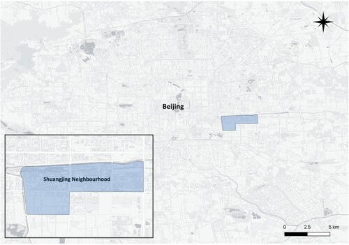
Shuangjing Neighbourhood is located in the east of Beijing and is a part of Chaoyang District. It is under the governance of Shuangjing Neighbourhood Office (SNO) – a subdistrict office of the Chaoyang District Government. To its north, Shuangjing neighbours Beijing’s Central Business District (CBD). Within Shuangjing, there are 13 residential compounds covering 5.08 km2 (). As an area developed in the early 2000s, its population of permanent residents has been 93,962 (Beijing Municipal Government, Citation2021).
Figure 1. Shuangjing Neighbourhood in Beijing. Source: by the authors.
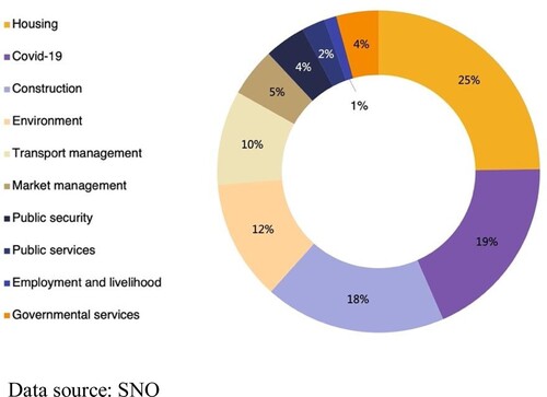
During the 1950s, Shuangjing was one of the five major industrial districts in Beijing. In 2002, R&F Group bought the land of a factory in Shuangjing and developed it into R&F City – the first commercially developed residential compound in Shuangjing Neighbourhood. The residential buildings that existed prior to 2002 mostly belonged to local factories. Nowadays, the entirety of Shuangjing has been deindustrialized and newly developed and decaying compounds co-exist side by side. The complaints voiced through the 12345 hotline deal mainly with issues related to housing, construction, cleanness, and transport management, in addition to Covid-19 pandemic control related issues ().
Figure 2. The composition of 12345 hotline complaints from Shuangjing residents (December 2019–December 2020). Data source: SNO.
4.2. Shuangjing International Sustainable Development Community Pilot
The Shuangjing Pilot is a collaborative project of UN-Habitat, the China Centre for Urban Development (CCUD), SNO, UrbanXYZ and the Beijing Community Research Centre (BCRC). It was a combination of two pilots: in January 2019, Shuangjing was selected by the Beijing Municipal Party Committee as a big data-based RUM pilot site; later, in July 2019, Shuangjing Neighbourhood was selected as a UN-Habitat International Sustainable Development Pilot Community, the first such community-level pilot of its kind in China. The goals of the two pilots are similar: to improve the built environment and achieve social, economic and environmental sustainability at the neighbourhood level. The first phase of both pilots was concluded in September 2020.
SNO took full ownership of the collaboration, with UN-Habitat and CCUD providing expertise and support on localizing and integrating the framework of the Sustainable Development Goals (SDGs) with RUM. UrbanXYZ and BCRC were appointed by SNO as the CDPs for Shuangjing Neighbourhood in June 2019. The two helped to design project activities in line with RUM requirements making reference to the SDGs framework and were likewise commissioned by SNO to carry out the action plan. The action plan gave room for flexibility, allowing for bottom-up activities to be integrated into the Pilot. These activities were not explicated in the action plan but shared the same goal.
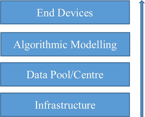
After one year, the Pilot generated several outputs, including the Street Brain dashboard, a mobile environmental monitoring system, a barrier-free smart cane, and two public space renewal projects: the Well No.1 and Well No.2 sites. These outputs are technically enabled by the four basic layers of the ‘smart neighbourhood’: infrastructure, data pool/centre, algorithmic modelling and end devices (). The infrastructure is composed of collecting and processing tools for internet data, IoT sensors, the 12345 hotline data portal, community smart cards, and grid-based neighbourhood survey mechanisms.Footnote6 The data pool/centre is built in a cloud server and channels all social sensing and real-time data, as well as survey and static data collected through the five data sources. The algorithmic modelling layer runs a neighbourhood-based built environment indicator system, 15-minute life-circle modelling, and urban design simulation modelling among other tools.
Figure 3. The four layers of the ‘Smart Neighbourhood’. Source: by the authors.
4.2.1 Street brain dashboard
The Shuangjing Street Brain dashboard () is similar to most Chinese mayor’s dashboards: a portal through which government leaders can have a real-time, holistic view of their city and coordinate actions and resource distribution accordingly. Built upon the previously mentioned four basic layers, the dashboard is composed of four functional modules: activity monitoring, evaluation, modelling and simulation, and implementation and management. The four modules are eventually tailored to and presented on the mayor’s mega LED display, and are accessible on the computers and mobile phone devices of neighbourhood workers.
Figure 4. Street Brain dashboard. Source: by the authors.
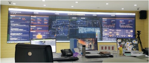
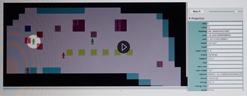
The functional modules are customized to the working scope of SNO. Activity monitoring visualizes the preliminary analysis of Shuangjing’s socio-demographic-environmental information. Data from 12345 hotline reports, waste sorting, and community activities are integrated in the data pool/centre. Evaluations are undertaken using the SDGs and built environment indicator system in reference to the UHC framework and the self-generated daily/weekly reports on the cases received via the 12345 hotline. The modelling and simulation layer visualizes the potential outcomes of specific interventions for improving public facilities and public space. Multi-agent simulation is used for optimizing the location of public facilities and design of public spaces (). Implementation and management integrates all spatial intervention and construction projects, such as micro-space regeneration, non-barrier facilities and others.
Figure 5. Multi-agent simulation for urban design. Source: by the authors.
4.2.2 Mobile environmental monitoring system
The mobile environmental monitoring system aims to proactively reduce 12345 hotline case reports by becoming aware of environmental issues at an early stage. It is composed of a mobile environmental sensor installed on law enforcement duty cars and a tablet in the car used by the staff on duty (). The sensors detect humidity, PM2.5 and PM10 concentration, and odour and noise levels, information which is also displayed on the mayor’s Street Brain dashboard at SNO. The GPS-embedded sensor runs during the urban management department’s daily patrols around the neighbourhood. Real-time data is transmitted through the NB-IoT network to the data centre. The data centre then analyses the received data and reports ‘abnormal values’ to the tablets held by the staff on duty. Staff can thereby monitor, check and proactively address environmental issues on-site in a timely manner.
Figure 6. Mobile environmental sensor. Source: by the authors.
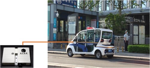
Table 1. Competing logics of top-down and bottom-up approaches in smart urbanization.
4.2.3 ‘smart cane’
The ‘smart cane’ (), was developed for conceptualizing the urban space as perceived by the blind. It works with a shock-wave sensor for detecting barriers in the path of visually impaired people. Initially, the ‘smart cane’ was an experiment developed by UrbanXYZ for an awareness-raising event ‘Walking with Blind Children’ held in November 2019. This event was co-organized by Sustainable Cities & Mobility (SCM),Footnote7 UrbanXYZ, and BCRC. During the event, one blind person was invited to test the smart cane, walking approximately two kilometres on a street near Shuangjing. Additionally, six blind children and ten blindfolded volunteers were invited to participate in the walk. The participants formed six groups, each group accompanied by a photographer from BCRC recording the environment and the behaviour of the participants. The data collected by the cane was later compared with the camera records for data analysis. The analytical results were written into an advocacy article and published on BCRC’s social media account.
Figure 7. ‘Smart cane’. Source: by the authors.
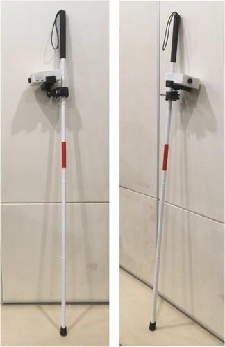
In December 2019, UrbanXYZ as the CDP was commissioned by SNO to carry out a survey and qualitatively evaluate existing barrier-free facilities in Shuangjing. In February 2020, the smart cane was used to collect data from the perspective of blind people to complement the qualitative data collected earlier by volunteers during the survey. The data generated from the project was then integrated onto the Street Brain dashboard.
4.2.4 Well No.1 site
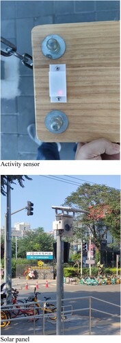
The Well No.1 and later Well No.2 sites were co-developed by BCRC and UrbanXYZ. The two projects started following BCRC’s land survey of the Shuangjing area carried out in September 2019 as part of an initiative to locate available land for neighbourhood revitalization. In November 2019, the Zhongshe Social Work Development Foundation launched the ‘Micro Space – Reborn for the Sunshine’Footnote8 project and held a design competition. BCRC took this opportunity and selected the site of Well No.1, a decayed public sports compound discovered during the survey, as its entry into the contest. Following construction completion, the space is now composed of facilities for sports and exercise and a children’s playground, and is equipped with solar-powered environmental monitoring sensors similar to those found in the municipal duty cars ( and ). The children’s facilities, including a trampoline, swings, and a spinning chair are installed with gyroscopes to sense and gather data on the use and activity on the rides which is then used to adjust the design of the space in the short-term and long-term future.
Figure 8. The Well No.1 site before and after revitalization. Source: by the authors.
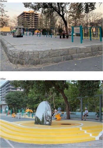
Figure 9. Sensors and activity monitoring at the Well No.1 site. Source: by the authors.
The site development process is composed of community participation, big-data supported evidence-based research, and modelling and simulation for design refinement. During the design stage, UrbanXYZ used feed from a camera installed at the intersection in front of the then unused open sports space site to obtain observational data on people’s behaviour. In December 2019, BCRC and Sketch ActionFootnote9 organized a participatory design workshop in which dozens of residents including local children participated. After further adjustments to the design based on the outcome of the workshop, BCRC consulted with residents and small business owners in the local area. In January 2020, BCRC’s and 16 other projects received funding from the Zhongshe Social Work Development Foundation. Between February and March 2020, BCRC began to run modelling and simulation on MaaS with NetLogo, and slightly adjusted their design to improve space utility. By July, construction was complete, with the real-time data collected through the sensors at the facilities integrated onto the mayor’s Street Brain dashboard.
4.2.5 Well No.2 site
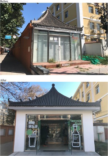
The Well No.2 site is a waste sorting facility. It is another project started by BCRC with an aim to create a social space and revitalize the neighbourhood. Before its renovation, the space was only irregularly used for some community activities including an English club, remaining unused for most of the time. In July 2020, as the BMG began promoting waste sorting initiatives at the neighbourhood level across Beijing, BCRC introduced ‘Aobag’ – a social-entrepreneurial technology start-up dedicated to environmental education and waste sorting which refurbished the underused space for waste sorting. In the space, residents are encouraged to sort waste through taking part in a cashback initiative. Aobag distributes QR-coded bags to users who are then instructed to register the bag and sort and dispose of their waste into different bags in the correct litter bin. As the sorted bags are embedded with a QR code, they can be traced back to unique user accounts for cashback or to incur penalties depending on whether waste is properly sorted. In the app, a dashboard visualizing the data generated from the site. A pie chart shows the composition of the waste. Next to it, the app also shows the total amount of household waste, participants, and improper sorting behaviours (). Environmental sensors are installed to detect odours and generate data visible on the Street Brain dashboard. The renewed space is also designed to be a social and educational space (). After construction, the maintenance of the site was funded by the Philanthropreneur Foundation, a charity foundation introduced by UrbanXYZ.
Figure 10. Aobag with QR code and Aobag app. Source: by the authors.
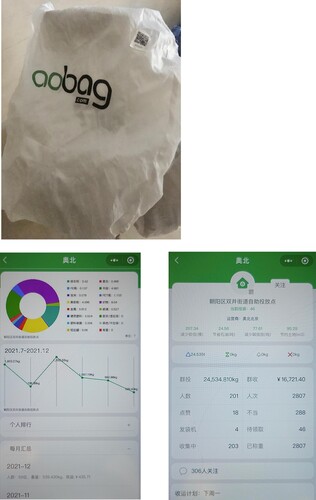
Figure 11. The Well No.2 site before and after revitalization. Source: by the authors.
4.3. Three paths towards integration
In the Pilot, three paths were taken by the CDPs to connect the top-down and bottom-up approaches. Firstly, the CDPs helped SNO identify gaps between the requirements of RUM/UHC and the needs of the residents (through 12345 hotline data), and developed ‘smart applications’ to improve the capacity of SNO for taking pro-active action. Secondly, they combined the CDP-initiated activities/development with the action plan of the Pilot. Thirdly, they introduced other bottom-up smart initiatives into the Pilot under the top-down framework.
The mobile environmental monitoring system is an example of the first path. It directly responds to the UHC indicator system and 12345 hotline complaints. SNO can therefore take pro-active action to improve its performance on related indicators of the built environment assessments and reduce the number of complaints concerning residents’ living environment.
Through the second path, the CDPs developed the smart cane for a barrier-free environment and the Well No.1 child-friendly micro space site. None of the outcomes were part of the initial action plan but were included under the framework of RUM. The smart cane was initially developed for an awareness-raising event and the Well No.1 site project took advantage of the design competition and channelled external funding resources to enable the renewal project. Meanwhile, the project developed ‘smart infrastructure’ including environmental sensors and gyroscopes for monitoring activity at the children’s facilities, pooling the data in the cloud.
The Well No.2 site took the third path. It was built upon the social entrepreneurial solution developed by Aobag and maintained through funding from a charity foundation. The initiative paired well with BMG’s own top-down waste sorting directives, with the data collected through Aobag being thoroughly integrated onto the Street Brain dashboard as previously mentioned.
Besides, it is worth noting that in the process of developing ‘smart applications’ and ‘smart spaces’, the CDPs need ‘smart tools’ to assist in their planning and spatial interventions. In the renewal process for the Well No.1 and Well No.2 sites, cameras, sensors and modelling simulations were engaged for public space design. Furthermore, the Pilot also developed a mobile-based land survey tool to assist the CDPs’ work which is now free and accessible to the public. Through the work of the CDPs, these applications are organically integrated within top-down frameworks.
5. Connecting top-down and bottom-up efforts through intermediary actors
The CDPs in the Pilot are typically intermediary actors. Similar to the role of urban planners in the testbed planning in the Nordic countries as investigated by Berglund-Snodgrass and Mukhtar-Landgren (Citation2020), CDPs as the contractors of the neighbourhood offices travel between two logics. In the Pilot, they translate between governmental long-term policies and communities’ short-term needs in the process of problem identification. They then linguistically and technically merge the two logics into one system, a system open and flexible to other bottom-up applications. Meanwhile, they play the role as resource mobilisers for public-private-society collaboration. This type of collaboration encourages learning, and further nurtures bottom-up experimentation and innovation.
To give a specific example, the Street Brain dashboard follows a top-down logic. SNO attempts to centralize the socio-economic-demographic information and environmental data to have a holistic view on the status of the entire neighbourhood. It enables SNO to undertake real-time quantitative self-assessments for pro-active action, and achieve good performance in the wider RUM/UHC evaluation conducted by departments higher up in the administrative hierarchy.
The mobile environmental monitoring system, smart cane, Well No.1 and Well No.2 sites, as well as the tools assisting the CDPs’ work are bottom-up initiatives and applications. They were essentially spontaneously developed as responses to problems identified by the CDPs. The spontaneity might be perceived as fragmentation, but in the context of the Pilot, ‘incremental’ might be a more precise description. First, the four applications all serve under the frameworks of RUM and UHC, which aim to improve the built environment and achieve social, economic and environmental sustainability at the neighbourhood level. The data they generate are integrated into the dashboard which provides a reference for SNO to coordinate resources. Secondly, in an urban area where infrastructure is maturely developed, incremental and targeted development is more likely to be the common practice.
However, there is a potential limitation to the CDPs’ role in bridging top-down and bottom-up approaches. While CDPs identify the gaps between the top-down and bottom-up approaches, the initiatives lean towards fulfilling top-down requirements, thereby potentially reducing the diversity of smart initiatives, with initiatives related to issues receiving the governments’ attentions likely encouraged relative to others. Besides, as the central system – Street Brain – itself is not an open system in the Pilot, CDPs’ power resides in selecting other bottom-up initiatives and fusing them into the top-down system.
6. Conclusion
In summation, urban work in China has transited from aggressive urban expansion to the environmental refinement of existing urban spaces. To realize RUM, the BMG implemented several measures including the UHC, the 12345 hotline, and the CDPs mechanism. UHC and the 12345 hotline, as accountability mechanisms, placed pressure on neighbourhood governments to improve, while smartification and big data are beginning to play a role for achieving RUM.
The Pilot indicates that an institutional planning arrangement placing intermediary actors at the neighbourhood level could play a significant role in bridging the gap between short-term development and long-term strategies for smart city planning. In the Chinese context, the CDPs take on this role and have the potential to influence smart urban development on a larger scale in the near future.
Learning from the Pilot, the intermediary actors for smart city development ideally share six features: familiarity with top-down governmental policies and long-term plans; a good grasp of urban knowledge for identifying bottom-up needs; the ability to translate and combine the two logics of top-down and bottom-up; IT knowledge to technically connect the two approaches; openness to stakeholder diversity in their collaborations; and the capability to mobilize multiple resources for action. Among these features, IT knowledge is exclusively the purview of intermediary actors in smart city development.
In the Pilot, the CDPs are also the developers of the smart applications, but this level of capability is not a must. However, this indicates that it would be ideal if education programs for community planners can incorporate elements of ICT in addition to traditional urban planning training in the near future. While intermediary actors are most likely to be community organizations or private firms, in contexts where mechanisms similar to the CDPs do not exist, the intermediary role can be fulfilled by groups or individuals who have mastery of IT and a good grasp of urban knowledge and planning.
Additionally, the Pilot also suggests that an open system is necessary for connecting top-down and bottom-up initiatives. Intermediary actors can help realize technical connections when the central information system is not fully open to independent developers. However, this approach potentially leads to exclusive selection. An open-source top-down system embracing bottom-up applications is the most ideal and should be encouraged in the future development of smart cities.
It is worth noting that intermediary actors’ work is ideally funded by the government to maintain motivation and a certain degree of neutrality. If the intermediary actor is a private firm, conflicts of interest become a valid concern; regulation and due diligence should be set in place to avoid this situation.
Acknowledgements
This study was supported by Yifang Foundation.
Disclosure statement
No potential conflict of interest was reported by the author(s).
Additional information
Funding
Notes
1 ‘Smart people’ concerns enabling environment for innovation and creativity (Camero & Alba, Citation2019).
2 MoHURD was the ministry that led urban planning before 2018. The 2018 organisational restructuring integrated urban planning into the newly established Ministry of Natural Resources (MNR).
3 See General Office of Ministry of Housing and Urban-Rural Development [2012] No.42. Retrieved from http://www.mohurd.gov.cn/wjfb/201212/t20121204_212182.html (in Chinese)
4 See National Development and Reform Commission [2014] No.1770. Retrieved from http://www.gov.cn/gongbao/content/2015/content_2806019.htm (in Chinese)
5 Xiong’an is a new special district approved by the State Council in 2017. Its long-term plan is to cover 2000 km2. It aims to be an open, green, and smart city featuring ecologically-sustainable high-end industry, high quality public services, and a high-speed and efficient transport network (Xinhua News Agency, Citation2017).
6 The grid-based community management system divides urban areas into grids or blocks. It enables digital platforms, social workers and police to collaborate in addressing social issues at the neighbourhood level (Global Times, Citation2020).
7 SCM is a nation-wide volunteers’ network that advocates for sustainable urban development.
8 Other collaborators of this project include the Chaoyang Branch of Beijing Planning and Natural Resources Committee, the Civil Affair Bureau of Beijing Chaoyang District, the Agricultural and Rural Affairs Bureau of Beijing Chaoyang District, and the Faculty of Architecture and Urban Planning, Beijing University of Technology.
9 Sketch Action is a Beijing-based NGO dedicating to community planning and public education on planning.
References
- Alibaba Cloud. (2018). Official Launch of ET City Brain 2.0 and Future City Lab by Alibaba Cloud’s President Simon Hu. Retrieved from https://www.alibabacloud.com/blog/jack-ma-at-the-computing-conference-2018-–-exploring-the-role-of-data-in-new-manufacturing_594084
- Arnstein, S. R. (1969). A ladder of citizen participation. Journal of the American Institute of Planners, 35(4), 216–224.
- Beijing Daily. (2019). Suggestions on enhancing urban refined management in Beijing. Retrieved from http://www.gov.cn/xinwen/2019-01/31/content_5362783.htm
- Beijing Municipal Government. (2021). The sixth census of Beijing. Retrieved from http://www.beijing.gov.cn/gongkai/shuju/sjjd/202105/t20210519_2392886.html
- Berglund-Snodgrass, L., & Mukhtar-Landgren, D. (2020). Conceptualizing testbed planning: Urban planning in the intersection between experimental and public sector logics. Urban Planning, 5(1), 96–106.
- Bjorklund, E. M. (1986). The danwei: Socio-spatial characteristics of work units in China’s Urban Society. Economic Geography, 62(1), 19–29. JSTOR.
- Bloomberg. (2012). China’s Urban Population Exceeds Countryside for First Time. Retrieved from https://www.bloomberg.com/news/articles/2012-01-17/china-urban-population-exceeds-rural
- Breuer, J., Walravens, N., & Ballon, P. (2014). Beyond defining the smart city: Meeting top-down and bottom-up approaches in the middle. Journal of Land Use, Mobility and Environment, Special Issue. https://doi.org/10.6092/1970-9870/2475
- Budthimedhee, K., Li, J., & George, R. V. (2002). Eplanning: A snapshot of the literature on using the world wide web in urban planning. Journal of Planning Literature, 17(2), 227–246.
- Camero, A., & Alba, E. (2019). Smart city and information technology: A review. Cities, 93, 84–94.
- Capdevila, I., & Zarlenga, M. I. (2015). Smart city or smart citizens? The Barcelona case. Journal of Strategy and Management, 8(3), 266–282.
- Cardullo, P., & Kitchin, R. (2019). Smart urbanism and smart citizenship: The neoliberal logic of ‘citizen-focused’ smart cities in Europe. Environment and Planning C: Politics and Space, 37(5), 813–830.
- Cardullo, P., Kitchin, R., & Di Feliciantonio, C. (2018). Living labs and vacancy in the neoliberal city. Cities, 73, 44–50.
- Carr, C., & Hesse, M. (2020). When Alphabet Inc. plans Toronto’s waterfront: New post-political modes of urban governance. Urban Planning, 5(1), 69–83.
- CAUPD. (2020). 2020 Urban Health Check Indicator System. (unpublished).
- Chai, Y., Long, Y., & Shen, Y. (2014). Big data application in China’s smart city planning. Urban Planning International, 29(6), 9–11.
- Chi, M. (2015). Why did China convene its first urban work conference in 37 years? Retrieved from https://www.chinadaily.com.cn/china/2015-12/30/content_22863986.htm
- Choi, M. (2016). A concept analysis of digital citizenship for democratic citizenship education in the internet Age. Theory & Research in Social Education, 44(4), 565–607.
- Couldry, N., & Powell, A. (2014). Big data from the bottom up. Big Data & Society, 1(2), 205395171453927.
- Cugurullo, F. (2018). Exposing smart cities and eco-cities: Frankenstein urbanism and the sustainability challenges of the experimental city. Environment and Planning A: Economy and Space, 50(1), 73–92.
- de Lange, M., & de Waal, M. (2013). Owning the city: New media and citizen engagement in urban design. First Monday, 18, 11.
- Global Times. (2020). Community grid system helps China fight virus. Retrieved from https://www.globaltimes.cn/content/1178528.shtml
- Hartford, K. (2005). Dear mayor: Online communications with local governments in Hangzhou and Nanjing. China Information, 19(2), 217–260.
- Hollands, R. G. (2008). Will the real smart city please stand up?: Intelligent, progressive or entrepreneurial?. City, 12(3), 303–320.
- Hollands, R. G. (2015). Critical interventions into the corporate smart city. Cambridge Journal of Regions, Economy and Society, 8(1), 61–77.
- Joss, S., Cook, M., & Dayot, Y. (2017). Smart cities: Towards a new citizenship regime? A discourse analysis of the British smart city standard. Journal of Urban Technology, 24(4), 29–49.
- Liu, Y. (2009). Community planning of Britain and its enlightenment to China. Planners, 25(3), 85–89.
- Liu, Y., Liu, X., Gao, S., Gong, L., Kang, C., Zhi, Y., … Shi, L. (2015). Social sensing: A new approach to understanding our socioeconomic environments. Annals of the Association of American Geographers, 105(3), 512–530.
- Manchester, H., & Cope, G. (2019). Learning to be a smart citizen. Oxford Review of Education, 45(2), 224–241.
- McGreevy, M. P. (2018). Complexity as the telos of postmodern planning and design: Designing better cities from the bottom-up. Planning Theory, 17(3), 355–374.
- Niederer, S., & Priester, R. (2016). Smart citizens: Exploring the tools of the urban bottom-up movement. Computer Supported Cooperative Work (CSCW), 25(2–3), 137–152.
- Niu, Q., & Song, X. (2012). Metadata-based urban planning information management: Toward comprehensive management of planning information. Urban Planning Forum, 2, 39–46. (in Chinese).
- Open Knowledge Foundation. (2013). Hello, China!. (in Chinese). Retrieved from https://cn.okfn.org/category/announcement/
- People’s Daily Online. (2016). Hangzhou to build ‘City Brain’ with Alibaba and Foxconn. Retrieved from http://en.people.cn/n3/2016/1013/c90000-9126738.html
- Potts, R. (2020). Is a new ‘planning 3.0’ paradigm emerging? Exploring the relationship between digital technologies and planning theory and practice. Planning Theory & Practice, 21(2), 272–289.
- Tencent. (2019). Industry accelerator. Retrieved from https://www.tencent.com/en-us/responsibility/support-start-up.html
- Thakuriah, P., Dirks, L., & Keita, Y. M. (2017). Digital infomediaries and civic hacking in emerging urban data initiatives. In P. Thakuriah, N. Tilahun, & M. Zellner (Eds.), Seeing cities through Big data (pp. 189–207). Cham: Springer.
- Tiezzi. (2013). China’s new urbanisation plan: A major conference on urbanisation in China prioritizes Hukou reform over construction and relocation projects. The Diplomat. Retrieved from https://www.bloomberg.com/news/articles/2012-01-17/china-urban-population-exceeds-rural
- UNDP. (2014). Harnessing the power of big data. Retrieved from https://www.cn.undp.org/content/china/en/home/presscenter/pressreleases/2014/08/harnessing-the-power-of-big-data/
- Wang, H. (2016). Evaluation of the effects of bottom-up management in preserving values of historic Hutong neighborhood in Beijing: A case study of Community-Based Organization (CBO)—Shijia Hutong Historic Preservation Society. Theses. University of Pennsylvania. Retrieved from https://repository.upenn.edu/cgi/viewcontent.cgi?article=1620&context=hp_theses
- Wang, H., & Zhu, S. (2020). The year of Beijing’s ‘12345’. China News. Retrieved from http://www.chinanews.com/gn/2020/01-03/9050246.shtml
- Wu, F. (2015). Planning for growth. London: Routledge.
- Wu, Y., Zhang, W., Shen, J., Mo, Z., & Peng, Y. (2018). Smart city with Chinese characteristics against the background of big data: Idea, action and risk. Journal of Cleaner Production, 173, 60–66.
- Xinhua News Agency. (2017). Authorised announcement: The Central Committee of China Communist Party and the State Council approved the establishment of Xiong’an New District, Hebei Province. (in Chinese). Retrieved from http://www.xinhuanet.com//politics/2017-04/01/c_1120741571.htm
- Zandbergen, D., & Uitermark, J. (2019). In search of the smart citizen: Republican and cybernetic citizenship in the smart city. Urban Studies, 57(8), 1733–1748.
- Zhang, C., & Chai, Y. (2014). Un-gated and integrated work unit communities in post-socialist urban China: A case study from Beijing. Habitat International, 43, 79–89.
- Zhao, W. (2009). Review and prospect: China’s urban housing construction and community evolution since 1949. Time Architecture, 2, 16–19.