
Abstract
Ecological restoration of river networks, especially of headwaters, is a key issue to improve water ecological, chemical and physical qualities and ecological functioning of aquatic ecosystems. Ecological restoration of degraded riparian vegetation is commonly considered as an efficient way to improve headwater habitats. This study aims to describe past management dynamics and their effect on current riparian vegetation structure and composition. We focused on two headwater brooks surrounded by traditional pasture in the rural catchment of the river Oir, a salmonid nursery of the river Sélune, Normandy, France. Historical riparian vegetation dynamic has been characterized thanks to interpretation of ortho-photographs from 1947 to 2010. GIS analyses allowed us to distinguish five types of management practices from stable vegetation (maintained open or maintained woody) to heterogeneous dynamic vegetation (alternation of clear-cutting, coppice management and recolonization by ligneous species). To measure their impact on the riparian ecosystem, past management practices were linked with field data describing current structure and composition of riparian vegetation. Results show that structure of riparian plant communities depends mainly on recent management practices, while floristic composition depends both on recent and past management practices. Knowledge of the past dynamics of riparian landscapes proves to be a relevant indicator of the ecological status of headwater ecosystems that could be used to improve ecological restoration instead of classical management practices of riparian vegetation.
Introduction
Restoration of headwaters is a key issue to improve the ecological, chemical and physical qualities of water and the ecological functioning of aquatic ecosystems (Saunders, Meeuwig, and Vincent Citation2002; Ormerod Citation2004; Meyer et al. Citation2007; Einum et al. Citation2007). Ecological restoration of degraded riparian vegetation (Bernez et al. Citation2004; Forget et al. Citation2013) and protection of a woody riparian vegetation buffer (Lecerf et al. Citation2012; Richardson, Naiman, and Bisson Citation2012) are commonly considered as efficient ways to improve headwater habitats in supporting biological production (Gregory, Li and Li Citation2002; Corenblit et al. Citation2009; Dosskey et al. Citation2010). Indeed, the influence of riparian areas is particularly crucial in small forested streams where inputs of organic matter support biological production in aquatic ecosystems (Wang, Seelbach, and Hughes Citation2006; Sakamaki and Richardson Citation2013). Spatial and temporal analysis of riparian vegetation dynamics allows better understanding of the physical and ecological processes for natural resource management (Goetz et al. Citation2003; Allan Citation2004; Dufour Citation2005; Bertoldi, Drake, and Gurnell Citation2011). Hence, there is a need to further consider ecological restoration and management practices with a spatially continuous analysis at an intermediate space and time scale (1–100 km, 5–50 years) within which many critical processes affecting populations and communities occur (Fausch et al. Citation2002; Ward, Malard, and Tockner Citation2002; Le Pichon Citation2006; Torgersen et al. Citation2006). Information about land-use history is often considered difficult to collect (Swetnam, Allen, and Betancourt Citation1999). However, metrics about riparian landscape dynamics can be easily built using remote sensing and geographic information systems (GIS) (Lassettre et al. Citation2008; Meixler and Bain Citation2010; Aguiar, Fernandes, and Ferreira Citation2011; Dufour et al. Citation2013). For instance, combination of historical photographs or vegetation maps allow us to describe transitions between two dates and therefore to infer stability or change in vegetation (Dufour Citation2005; Sawtschuk and Bioret Citation2012; Shen, Sakai, and Kaji Citation2013; Gallet and Sawtschuk Citation2014). This suggests a high potential for ortho-pictures to trace past management practices. Such indicators of riparian vegetation dynamics could help river managers to integrate contextual riverine landscape information into their choices to move from classical river management to landscape ecological engineering and ecological restoration of headwater ecosystems. Our study describes management practices of riparian areas and theirs effects on vegetation in a headwater ecosystem of the Oir catchment (Normandy, France). In this rural landscape, streams are surrounded by traditional pastures. Woody riparian vegetation development is limited by cattle access to the river and by tree management conducted by local farmers and stakeholders. In the past decade, management practices have changed; river managers increased stream bank protection allowing colonization by trees (Forget et al. Citation2013).
The objectives of this study are (i) to develop a method based on photo-interpretation and GIS analysis for assessing historical management of the riparian vegetation structure; (ii) to describe the impacts of the historical management on current structure and botanical composition of banks to improve passive ecological restoration practices.
Material and methods
Study area
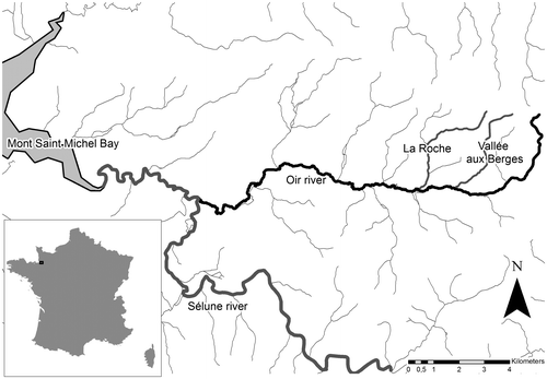
Our study is carried out in southern Normandy (France) 20 km east of the Mont St Michel Bay in the Oir River watershed, a tributary of the dammed Sélune river (Figure ). The Oir river is the principal wild Atlantic salmon, sea trout and brown trout nursery of the regulated River Sélune. Ecological surveys have been carried out for 20 years evaluating connections between the quality of salmon and trout populations and the habitat quality (Bagliniere, Marchand, and Vauclin Citation2005). Near the streams, the watershed landscape (a typical Normandy bocage network) is mainly composed of traditional pastures surrounded by hedgerows that alternate in the above part of the valley with cultivated fields. The riparian vegetation is characterized by a mosaic of open grazed meadows and woody riparian vegetation resulting from management practices by local farmers and stakeholders (cattle access to the river, tree cutting). Megaphorbia, meadow and shrub species (Oenanthe crocata L. and Holcus lanatus L., Rubus L. sp.) alternate with low woody vegetation (Corylus avellana L., Salix atrocinerea Brot. and young trees) or taller trees (Alnus glutinosa (L.) Gaertn., Quercus robur L., Fraxinus excelsior L.). We focused on two comparable second-order tributaries of the Oir River, Vallée-Aux-Berges (VAB) and La Roche (Figure ). Both streams are approximately 5 km long. We considered for our study 2 km of the lower part of each stream, presenting a channel width between 50 cm and 2 m. Local hydrological conditions of the La Roche stream are detailed in Acolas (Citation2008): the brook has an average channel width of 1.5 m and a mean slope of 3.6% with a gravel- and cobble-dominated substratum. Restoration of stream banks highly impacted by livestock began on VAB in 2004 and in 2012 on La Roche by using exclusionary fencing and feeding troughs and footbridges, allowing passive ecological restoration (Forget et al. Citation2013).
Figure 1. Oir River catchment area and location of study area: La Roche and Vallée aux Bergres (VAB).
Riparian landscape data acquisition
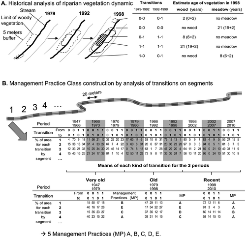
To define spatiotemporal management practices, historical analysis of aerial photographs was performed on 10 available pictures (1947, 1966, 1970, 1979, 1986, 1992, 1998, 2002, 2007 and 2010). In the open meadow valley, image resolution was good enough (~ 1 m) to digitize manually woody riparian vegetation limits using GIS (Arcmap 10). For each photograph, we delineated woody riparian vegetation patches in a 5-m buffer strip around the stream. Scale was 1/1000, and minimal object size was 2 m. In this way we identified two different stages: woody (1) or open (0) (Figure A).
Figure 2. Methodology for historical analysis of riparian landscape and Management Practice (MP) construction according to transitions between wooded (= 1) and open vegetation (meadow = 0); the five MP (A, B, C, D and E) are obtained by cluster analysis based on transitions. Transitions : 1-1 = stable wood, 0-0 = stable meadow, 0-1 = colonization by wood, 1-0 = wood cutting.
Vegetation dynamic and management practices
We used the transition between woody (1) and open (0) stages as an indicator of vegetation dynamic during the period between two photographs. Hence, we distinguished stable bank vegetation: stable wood (1-1) or stable meadow (0-0), from dynamic bank vegetation: colonization by wood (0-1) or woodcutting (1-0). Further, streams were divided into 198 segments with a length of 20 m and a width of 10 m (110 segments at La Roche, 88 at VAB). Between each photo, the percentage of area concerned by each transition (0-0, 0-1, 1-0, 1-1) was calculated per segment using GIS (Figure B). Finally, average percentages of the areas concerned by each transition were calculated for recent (1998–2010), old (1979–1998) and very old (1947–1979) historical periods. Transitions for each period were obtained by analysis of four consecutive aerial photographs forming three observed transitions by period: recent (1998–2002, 2002–2007, 2007–2010), old (1979–1986, 1986–1992, 1992–1998) and very old (1947–1966, 1966–1970, 1970–1979). Transition data concerning recent, old and very old periods were compiled in a 594-segment data set and a cluster analysis was performed (using Ward’s method) to distinguish groups of management practices.
Age
The age of woody and open vegetation patches was also estimated in 2010 using the minimum age obtained by this historical data set (Figure A) to which we added 2 years (half of the minimum number of years between two pictures and also minimum age estimated for a tree to be visible on an aerial photograph). The oldest vegetation patches are older than 65 years and the youngest have an estimated age of 2 years.
Riparian vegetation structure and composition field data
The vegetation of the two streams was surveyed on the field in 2012 and 2013 between summer and autumn, which corresponds to the maximum tree canopy cover. Riparian vegetation structure and composition were described in each 20-m segment on both sides of streams in a 1-m area around the stream. Riparian woody vegetation cover was estimated (percentage of the segment covered by woody vegetation) and tree trunks were counted. Then, woody vegetation was divided into three strata: small shrub (between 0.5 and 2 m), shrub (between 2 and 6 m), and tree (above 6 m). For each, we estimated the global percentage cover per stratum and the percentage cover of the part of the stratum that overhangs the stream (which can be different from the stratum cover, especially for the small shrubs that may be present on the banks but not overhanging the stream). Finally, again for each stratum, we listed all woody species and their corresponding cover (in percentage). We also noted global megaphorbia grass, forb and fern cover (especially in segments with open vegetation).
Analysis of riparian landscape dynamic effect on vegetation structure and composition
The influence of riparian landscape dynamics on vegetation structure and composition was investigated on the 198 segments using generalized linear mixed models to account for non-independence in the data (Bolker et al. Citation2009). We built a set of models in which vegetation structure and composition data were the response variables and management practices were the predictive nominal data.
The management practices and interactions between stream identity and recent management practices were included as fixed effects. We also defined stream identity as random effects. The models were fitted using R software (R Development Core Team Citation2004) with the lmer function (package lme4, Bates and Sarkar Citation2007).
We tested differences between each mean of response variables according to management practice groups using Student’s t-tests or Wilcoxon tests. Most of the variables describing the structure of the riparian environment (trunk density, strata covers) followed a simple normal law. In contrast, the variables describing the composition (percentage of covering of species and species richness) usually had a Poisson distribution. To describe the composition of each stratum we integrated into the models only the dominant species (total cover superior to 5%).
Results
Vegetation Management Practices
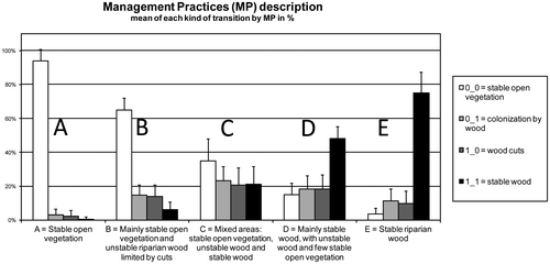
Cluster analysis distinguished five vegetation Management Practices (MP) (Figure ) that can be ordered from MP A, dominated by open stable open vegetation (0-0 transition) managed by grazing or mowing, to MP E dominated by stable wood (1-1 transition). Wood cuts (1-0 transitions) or wood colonization (0-1 transition) are more represented in MP B, MP C and MP D (Figure ).
Figure 3. Management Practice Class description according transition (0 = open vegetation, 1 = riparian wood), 1-1 = stable wood; 0-0 = stable open vegetation, 0-1 = colonization by wood and 1-0 = wood cuts.
Riparian landscape changes
The five management practices are present on both streams and for the three periods (Figure ), except for MP E, which is absent from VAB stream between 1979 and 1998. On the 594 segments analysed the most common management practices were MP C (187 segments) and MP A (173 segments). MP C (mixed areas with both stable open and wooded vegetation) is mainly represented in La Roche stream, whereas MP A (stable open vegetation) is more common in the VAB landscape. MP E (stable wood) is the less common management practice in the studied area (61 segments), and occurs mainly in La Roche.
Figure 4. Riparian landscape changes according to riparian Management Practices (MP).
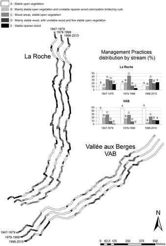
Management practices of riparian vegetation fluctuate during the three periods under consideration (Figure ). Open and dynamic management practices A, B and C have increased during the 1979–1998 period and decreased more recently. In contrast, stable woody MP D and MP E have at first regressed between 1947–1979 and 1979–1998 before progressing in 1998–2010. Hence, recent management practices of riparian vegetation tend to return to the very old management practices with more stable vegetation (especially stable woods).
On La Roche, MP C is always dominant: vegetation is more heterogeneous and dynamic than stable. Stable riparian woods (MP D and MP E) are also well represented especially in the first and last periods. VAB has a different context: open and stable vegetation (MP A) is always widely dominant and tends to increase with time. Heterogeneous and dynamic open vegetation (MP B and MP C) has progressively decreased while stable woody vegetation (MP D and MP E), which was rare in the past, has tended to develop recently.
Hence, vegetation in La Roche is more woody and dynamic than in VAB where the vegetation is open and stable. Spatial representation of MP shows that open riparian vegetation and woody riparian vegetation remain rather stable in time and in space (Figure ).
Management practice effects on current vegetation structure and composition
We tested the effect of management practice on actual vegetation structure and composition for the three periods (1947–1979, 1979–1998 and 1998–2010); results showed that the most recent management practices (1998–2010) explain significantly almost all differences in vegetation structure. Meanwhile, composition is explained not only by recent management practice but also by old and very old practices. Table displays generalized model results for each parameter.
Table 1. GLMM results of recent and old and very old Management Practices effect on current vegetation structure and vegetation composition parameters.
Structure
The different models (Table ) show that recent management practices have the most significant effect on riparian vegetation structure, shrub overhang cover being the only exception. Interaction between recent MP and brook effect on vegetation structure is non-significant for half of the variables, showing that management practice effects on the structure can be independent of or dependent on the local context.
Some parameters such as tree cover, overall cover, tree overhang and wooded patch ages match well with the MP gradient from open stable vegetation (MP A, MP B) to mixed heterogeneous vegetation (MP C) to stable riparian wood (MP D, MP E). We observed that MP D segments have significantly fewer small shrubs on their banks than those with MP E.
Composition
Alnus glutinosa is the dominant species for all strata and all management practices (Table ). Its covering in the two small strata is favoured by open environments. MP B and MP C are indeed characterized by a low tree cover, but have a lot of alders in the shrub stratum. Nevertheless, in the tree stratum we see that alders occur more frequently in wooded patches, like in the banks of MP D and MP E. Quercus robur is important in stable old wooded patches in the tree stratum. In the small shrub stratum, megaphorbia plants and grass cover are more important in the segments of MP A (open and stable) than in the others.
Table 2. Recent Management Practices effect on actual vegetation structure and vegetation composition parameters (different letters indicate significant differences in mean values).
Ligneous species diversity in both shrub and tree strata increases from class A to class C: the older the wooded patches are, the more diverse.
As for the structure, models show that management has a significant effect on riparian vegetation composition (Table ). Only Salix atrocinerea cover for both small shrub and shrub strata and fern cover are not significant. However, management practice effect on species cover depends on the local context (brook effect), showing that management practice knowledge is not sufficient to efficiently predict vegetation composition.
Discussion
Diachronical ortho-photograph analysis as a tool to describe past wood riparian vegetation management
Diachronical analysis of ortho-photographs allowed us to describe spatiotemporal changes in vegetation and the riparian landscape (Miller et al. Citation1995; Apan, Raine, and Paterson Citation2002). Going further by considering transitions, we managed to interpret them in terms of riparian wood management practices over the last six decades. This confirmed that remote sensing can be employed to learn more about the changes of management practices, especially in wooded areas (Hammi et al. Citation2010; Meixler and Bain Citation2010; Matsuura and Suzuki Citation2012). Our results reflected heterogeneity of management practices at both temporal (very old, old and recent management practices) and spatial level (two neighbouring brooks in the same catchment area).Variability of management practices occurs between the two brooks of the same catchment, but also at a more local scale within each brook. It confirmed that management practices are widely linked with the local socio-cultural context, depending on individual landowner practices (Shandas Citation2007; Fernandes, Aguiar, and Ferreira Citation2011): our findings support this, adding that these individual farming practices over time have produced a patchy river basin history, which explains the community vegetation composition.
We also pointed out more global trends of management practice through time: wood development was observed recently in both streams and a global increase of open vegetation during the 1978–1998 period. This showed that management practice changes also occurred over time on a wider scale, which can result from political or societal changes rather than from local owner choices (Baudry et al. Citation2000).
Management practices impact riparian wooded vegetation structure and composition
Our results showed a strong relation between the way riparian vegetation has been managed in the past and its current structure/composition.
Results on structure are in accordance with Hammi et al. (Citation2010), who identified a significant effect of management practices between 1967 and 2005 on forest structure in the Moroccan High Atlas Mountains. Such effects have also been identified in other contexts more specifically on tree (Palo, Ivask, and Liira Citation2013) and shrub (Redhead et al. Citation2012) strata. As did Zimmerman et al (Citation1995), we found that old management practices had an effect on composition, while structure was only affected by recent management.
Relations between composition and management practices has already been pointed out for hedgerows (Schmitz, Sánchez, and De Aranzabal Citation2007), especially for some of the species that we observed (Julien, Balent, and Alard Citation2006 for Fraxinus excelsior; Palo, Ivask, and Liira Citation2013 and Welander and Ottosson Citation1998 for Quercus robur)
Indeed, in our context, trees (especially Quercus robur, Fraxinus excelsior and Corylus avellana) tend to be favoured by frequent cuttings. Passive ecological restoration of riparian vegetation by fencing should improve oak colonization in limiting oak seed predation by cattle (Gómez, Garcia, and Zamora Citation2003; Rey Benayas et al. Citation2005). The common Hazel, Corylus avellana, appears to be found more in regularly cut riparian woods. This species is almost absent when tree colonization starts from old open meadow vegetation. This can be explained by seed dispersion of nuts, often performed by rodents (Vander Wall Citation2001) that only bury the seeds where they can hide them efficiently (old stumps, hedge slopes) promoting hazel dispersion in already forested places. Alder tree, Alnus glutinosa, is the dominant species in all strata. This pioneer species is the first to be well established after restoration (Forget et al. Citation2013), it is well adapted to light and wet soils.
The absence of management practice effect on willow cover in the lower stratum can be compared to previous results obtained by Forget et al. (Citation2013) in a study on landscape effect on bank colonization by trees. They showed that colonization by willows is not dependent on hedgerow proximity, contrary to other ligneous species such as alder, oak or hazel. Hence, management practices and landscape structure appear to have a low influence on willow distribution, which probably relies more on hydrology and meteorology conditions for establishment of young trees (Foussadier Citation1998).
Importance of a multi-scale approach
If management practices have equal effects on the structure of all riparian ecosystems studied, those effects also rely on local context, especially for species composition. Indeed, riparian vegetation structure and composition depend on the land use close to the river (Martin et al. Citation2006; Fernandes, Aguiar, and Ferreira Citation2011). For instance, landscape context (particularly hedgerow network) widely influences tree recruitment and also has a strong impact on riparian composition (Forget et al. Citation2013).
Our results also tend to show that that riparian vegetation is influenced by local management practices, which depend both on local land use (heterogeneity in space at the stream scale) and on trends linked to more general socio-economic changes (change at regional scale linked to the evolution of agricultural policies).
Perspectives for ecological restoration survey/monitoring
In our study, remote sensing and particularly historical aerial photographs proved efficient tools for monitoring and assessing management of wooded areas (Johansen et al. Citation2010; Redhead et al. Citation2012).
Development of new remote sensing technologies applied to environment management and especially riparian vegetation management and restoration must be encouraged (Wang, Seelbach, and Hughes Citation2006; Meixler and Bain Citation2010; Johansen et al. Citation2010; Dufour et al. Citation2013). Image acquisition by unmanned aerial vehicles is currently tested on our study sites (Dufour et al. Citation2013); this technology is very useful, providing high-resolution photographs that could be replicated every year at low cost, which allows us to follow the evolution of tree cover and height.
Spatiotemporal heterogeneity in management practices has been identified as a key factor for conservation of the functions and biodiversity of riparian vegetation (Ward, Malard, and Tockner Citation2002; Meleason, Gregory, and Bolte Citation2003). Effects of management practices vary according to the species considered whether ligneous or even herbaceous (Palo, Ivask, and Liira Citation2013; study in progress for our streams). The different ligneous species on our two streams are not all favoured similarly by the same management practice and these management practices rely on land use over time. Therefore, ecological restoration of riparian and stream ecosystems needs to go further in the consideration of management practices of surrounding landscapes (Martin et al. Citation2006) and must involve landowners as key partners for success (Shandas Citation2007).
Our results raise the question of the scale that must be considered for ecological restoration projects. Indeed, restoring a whole stream or catchment may encourage the homogenization of management practices and consequently of biodiversity. Hence, at the catchment scale, how many streams do we need to restore? Which ones? Following which time-table? And then, at the stream scale: which parts should be restored?
To answer those questions, we need to integrate the consideration of the river basin history at a landscape level. Therefore, remote sensing is a good tool to develop landscape indicators about management practices and will help to identify suitable scales for ecological restoration plans.
Acknowledgements
Thanks to Dr Bernard West for the English revision. This study was funded by the Interreg IVb Atlantic Aquatic River Conservation, The French National Agency for Water and Aquatic Environments (ONEMA, National Office of Water and Aquatic Ecosystems), and is prolonged by the French Ministry of Ecology (Stratégie Nationale pour la Biodiversité, Biodiversity National Strategy) and the Water Agency Seine-Normandie (AESN).
References
- Acolas, M. L. 2008. “Déterminisme des tactiques de vie chez la truite commune Salmo trutta : influences maternelles et environnementales sur le comportement migratoire des juvéniles.” [Determinism of life history tactics in brown trout Salmo truta: maternal and environmental influences on migratory behaviour of juveniles.] PhD thesis, University of Caen.
- Aguiar, F. C., M. R. Fernandes, and M. T. Ferreira. 2011. “Riparian vegetation metrics as tools for guiding ecological restoration in riverscapes.” Knowledge and Management of Aquatic Ecosystems 402: 21.
- Allan, J. D. 2004. “Landscapes and River Use: The Influence of Land Use on Stream Ecosystems.” Annual Review of Ecology, Evolution, and Systematics 35: 257–284.
- Apan, A. A., S. R. Raine, and M. S. Paterson. 2002. “Mapping and analysis of changes in the riparian landscape structure of the Lockyer Valley catchment, Queensland, Australia.” Landscape and Urban Planning 59: 43–57.
- Bagliniere, J., F. Marchand, and V. Vauclin. 2005. “Interannual changes in recruitment of the Atlantic salmon (Salmo salar) population in the River Oir (Lower Normandy, France): relationships with spawners and in-stream habitat.” Journal of Marine Science 62: 695–707.
- Bates, D., and D. Sarkar. 2007. Lme4: Linear Mixed-effects Models Using S4 Classes. R package version 0.99875-6.
- Baudry, J., F. Burel, C. Thenail, and D. Le Coeur. 2000. “A holistic landscape ecological study of the interactions between farming activities and ecological patterns in Brittany, France.” Landscape and Urban Planning 50: 119–128.
- Bernez, I., H. Daniel, J. Haury, and M. T. Ferreira. 2004. “Combined effects of environmental factors and regulation on macrophyte vegetation along three rivers in western France.” River Research and Applications 20: 43–59.
- Bertoldi, W., N. A. Drake, and A. M. Gurnell. 2011. “Interactions between river flows and colonizing vegetation on a braided river: exploring spatial and temporal dynamics in riparian vegetation cover using satellite data.” Earth Surface Processes and Landforms 36: 1474–1486.
- Bolker, B. M., M. E. Brooks, C. J. Clark, S. W. Geange, J. R. Poulsen, M. H. H. Stevens, and J.-S. S. White. 2009. “Generalized linear mixed models: a practical guide for ecology and evolution.” Trends in Ecology & Evolution 24: 127–135.
- Corenblit, D., J. Steiger, A. M. Gurnell, and R. J. Naiman. 2009. “Plants intertwine fluvial landform dynamics with ecological succession and natural selection: a niche construction perspective for riparian systems.” Global Ecology and Biogeography 18: 507–520.
- Dosskey, M. G., P. Vidon, N. P. Gurwick, C. J. Allan, T. P. Duval, and R. Lowrance. 2010. “The role of riparian vegetation in protecting and improving chemical water quality in streams.” Journal of the American Water Resources Association 46: 261–277.
- Dufour, S. 2005. “Contrôles naturels et anthropiques de la dynamique des forêts des cours d’eau du bassin Rhodanien (Ain, Arve, Drôme et Rhône).” [Natural and anthropic controls of riparian forests dynamics in the Rhone basin (Ain, Arve, Drôme and Rhône), France] PhD thesis. University Jean Moulin Lyon 3, Lyon.
- Dufour, S., I. Bernez, J. Betberger, S. Corgne, L. Hubert-Moy, J. Nabucet, S. Rapinel, J. Sawtschuk, and C. Trolle. 2013. “Monitoring restored riparian vegetation: how can recent developments in remote sensing sciences help?” Knowledge and Management of Aquatic Ecosystems 410 10 http://dx.doi.org/10.1051/kmae/2013068.
- Einum, S., K. H. Nislow, J. D. Reynolds, and W. J. Sutherland. 2007. “Predicting population responses to restoration of breeding habitat in Atlantic salmon: effects of breeding habitat restoration.” Journal of Applied Ecology 45: 930–938.
- Fausch, K. D., C. E. Torgersen, C. V. Baxter, and H. W. Li. 2002. “Landscapes to riverscapes: bridging the gap between research and conservation of stream fishes.” BioScience 52: 483–498.
- Fernandes, M. R., F. C. Aguiar, and M. T. Ferreira. 2011. “Assessing riparian vegetation structure and the influence of land use using landscape metrics and geostatistical tools.” Landscape and Urban Planning 99: 166–177.
- Forget, G., C. Carreau, D. Le Coeur, and I. Bernez. 2013. “Ecological restoration of headwaters in a rural landscape (Normandy, France): a passive approach taking hedge networks into account for riparian tree recruitment.” Restoration Ecology 21: 96–104.
- Foussadier, R. 1998. “Initiation des successions végétales dans les lits endigués des cours d’eau alpins: influence des paramètres abiotiques sur la régénération des Salicacées.” [Initiation of vegetative succession in alpine floodplains: softwood forest development in relation to hydrology and riverbank morphology.] PhD thesis, Université de Grenoble 1, Saint-Martin-d’Hyères, France.
- Gallet, S., and J. Sawtschuk. 2014. “Restoration dynamics evaluation by vegetation mapping and transition matrix modeling: analysis of 20 years of restoration and management at the megalithic site of Carnac (Brittany, France).” Applied Vegetation Science 17: 225–235.
- Goetz, S. J., R. K. Wright, A. J. Smith, E. Zinecker, and E. Schaub. 2003. “IKONOS imagery for resource management: Tree cover, impervious surfaces, and riparian buffer analyses in the mid-Atlantic region.” Remote Sensing of Environment 88: 195–208.
- Gómez, J. M., D. Garcia, and R. Zamora. 2003. “Impact of vertebrate acorn – and seedling – predators on a Mediterranean Quercus pyrenaica forest.” Forest Ecology and Management 180: 125–134.
- Gregory, S., H. Li, and J. Li. 2002. “The conceptual basis for ecological responses to dam removal: resource managers face enormous challenges in assessing the consequences of removing large dams from rivers and evaluating management options.” BioScience 52: 713–723.
- Hammi, S., V. Simonneaux, J. B. Cordier, D. Genin, M. Alifriqui, N. Montes, and L. Auclair. 2010. “Can traditional forest management buffer forest depletion? Dynamics of Moroccan High Atlas Mountain forests using remote sensing and vegetation analysis.” Forest Ecology and Management 260: 1861–1872.
- Johansen, K., L. A. Arroyo, J. Armston, S. Phinn, and C. Witte. 2010. “Mapping riparian condition indicators in a sub-tropical savanna environment from discrete return LiDAR data using object-based image analysis.” Ecological Indicators 10: 796–807.
- Julien, M.-P., G. Balent, and D. Alard. 2006. “Patterns of ash (Fraxinus excelsior L.) colonization in mountain grasslands: the importance of management practices.” Plant Ecology 183: 177–189.
- Lassettre, N. S., H. Piégay, S. Dufour, and A.-J. Rollet. 2008. “Decadal changes in distribution and frequency of wood in a free meandering river, the Ain River, France.” Earth Surface Processes and Landforms 33: 1098–1112.
- Le Pichon, C. 2006. “Une approche “paysage aquatique” pour une meilleure connaissance du fonctionnement des écosystèmes fluviaux et l’amélioration de la conservation des peuplements de poissons.” [A riverscape approach for a better understanding of fluvial ecosystems and improvement of fish stocks conservation] PhD thesis, University of Paris VI, Paris.
- Lecerf, A., J.-M. Baudoin, A. A. Besson, S. Lamothe, and C. Lagrue. 2012. “Is smaller necessarily better? Effects of small-scale forest harvesting on stream ecosystems.” International Journal of Limnology 48: 401–409.
- Martin, T. G., S. McIntyre, C. P. Catterall, and H. P. Possingham. 2006. “Is landscape context important for riparian conservation? Birds in grassy woodland.” Biological Conservation 127: 201–214.
- Matsuura, T., and W. Suzuki. 2012. “Analysis of topography and vegetation distribution using a digital elevation model: case study of a snowy mountain basin in northeastern Japan.” Landscape and Ecological Engineering 9: 143–155.
- Meixler, M. S., and M. B. Bain. 2010. “Landscape scale assessment of stream channel and riparian habitat restoration needs.” Landscape and Ecological Engineering 6: 235–245.
- Meleason, M. A., S. V. Gregory, and J. P. Bolte. 2003. “Implications of riparian management strategies on wood in streams of the Pacific Northwest.” Ecological Applications 13: 1212–1221.
- Meyer, J. L., D. L. Strayer, J. B. Wallace, S. L. Eggert, G. S. Helfman, and N. E. Leonard. 2007. “The Contribution of Headwater Streams to Biodiversity in River Networks.” Journal of the American Water Resources Association 43: 86–103.
- Miller, J. R., T. T. Schulz, N. T. Hobbs, K. R. Wilson, D. L. Schrupp, and W. L. Baker. 1995. “Changes in the landscape structure of a southeastern Wyoming riparian zone following shifts in stream dynamics.” Biological Conservation 72: 371–379.
- Ormerod, S. J. 2004. “A golden age of river restoration science?” Aquatic Conservation: Marine and Freshwater Ecosystems 14: 543–549.
- Palo, A., M. Ivask, and J. Liira. 2013. “Biodiversity composition reflects the history of ancient semi-natural woodland and forest habitats—compilation of an indicator complex for restoration practice.” Ecological Indicators 34: 336–344.
- R Development Core Team 2004. R: A Language and Environment for Statistical Computing. Vienna, Austria: R Foundation for Statistical Computing.
- Redhead, J., M. Cuevas-Gonzales, G. Smith, F. Gerard, and R. Pywell. 2012. “Assessing the effectiveness of scrub management at the landscape scale using rapid field assessment and remote sensing.” Journal of Environmental Management 97: 102–108.
- Rey Benayas, J. M., J. Navarro, T. Espigares, J. M. Nicolau, and M. A. Zavala. 2005. “Effects of artificial shading and weed mowing in reforestation of Mediterranean abandoned cropland with contrasting Quercus species.” Forest Ecology and Management 212: 302–314.
- Richardson, J. S., R. J. Naiman, and P. A. Bisson. 2012. “How did fixed-width buffers become standard practice for protecting freshwaters and their riparian areas from forest harvest practices?” Freshwater Science 31: 232–238.
- Sakamaki, T., and J. S. Richardson. 2013. “Nonlinear variation of stream-forest linkage along a stream-size gradient: an assessment using biogeochemical proxies of in-stream fine particulate organic matter.” Journal of Applied Ecology 50 (4): 1019–1027.
- Saunders, D. L., J. J. Meeuwig, and A. C. J. Vincent. 2002. “Freshwater protected areas: strategies for conservation.” Conservation Biology 16: 30–41.
- Sawtschuk, J., and F. Bioret. 2012. “Analyse diachronique de la dynamique spatiale de la végétation de l’estuaire de la Loire.” [Diachronical analysis of vegetation spatial dynamic in the Loire estuary.] Photo Interpretation – European Journal of Appied Remote Sensing 48: 15–28.
- Schmitz, M. F., I. A. Sánchez, and I. De Aranzabal. 2007. “Influence of management regimes of adjacent land uses on the woody plant richness of hedgerows in Spanish cultural landscapes.” Biological Conservation 135: 542–554.
- Shandas, V. 2007. “An empirical study of streamside landowners’ interest in riparian conservation.” Journal of the American Planning Association 73: 173–184.
- Shen, G., K. Sakai, and K. Kaji. 2013. “Capturing landscape changes and ecological processes in Nikko National Park (Japan) by integrated use of remote sensing images.” Landscape and Ecological Engineering 9: 89–98.
- Swetnam, T. W., C. D. Allen, and J. L. Betancourt. 1999. “Applied historical ecology: Using the past to manage for the future.” Ecological Applications 9: 1189–1206.
- Torgersen, C. E., C. V. Baxter, H. W. Li, and B. A. McIntosh. 2006. “Landscape influences on longitudinal patterns of river fishes: spatially continuous analysis of fish-habitat relationships.” In American Fisheries Society Symposium 48, edited by M. Hugues, L. Wang, and P. Seelbach, 473–492. Bethesda, MD: American Fisheries Society.
- Vander Wall, S. B. 2001. “The evolutionary ecology of nut dispersal.” The Botanical Review 67: 74–117.
- Wang, L., P. W. Seelbach, and R. M. Hughes. 2006. “Introduction to landscape influences on stream habitats and biological assemblages.” In American Fisheries Society Symposium 48, edited by M. Hugues, L. Wang and P. Seelbach, 1–23. Bethesda, MD: American Fisheries Society.
- Ward, J. V., F. Malard, and K. Tockner. 2002. “Landscape ecology: a framework for integrating pattern and process in river corridors.” Landscape Ecology 17: 35–45.
- Welander, N., and B. Ottosson. 1998. “The influence of shading on growth and morphology in seedlings of Quercus robur L. and Fagus sylvatica L.” Forest Ecology and Management 107: 117–126.
- Zimmerman, J. K., T. M. Aide, M. Rosario, M. Serrano, and L. Herrera. 1995. “Effects of land management and a recent hurricane on forest structure and composition in the Luquillo Experimental Forest, Puerto Rico.” Forest Ecology and Management 77: 65–76.