
ABSTRACT
The Murray-Darling River system is perhaps Australia’s most important, with significant social, cultural and environmental values including 16 Ramsar listed wetlands. The MDB is home to 2.6 million people and produces about $24 billion worth in agricultural production each year (about one-third of total value for Australia). Hydrologic issues, typified by water availability and quality, have existed for many years, peaking during the Millennium drought from 1997 to 2010. Competing interests (i.e. irrigation, tourism, environmental heath), and the declining flows and water quality during droughts, led governments and water management agencies to consider the risks to water resources in the system in the early-mid 2000s. This paper reviews changes to risks associated with forest dynamics, as identified by - afforestation and bushfire – and considers new issues that have emerged since that analysis. It was found that the potential impacts of bushfire on stream flows were over-estimated in past studies, and that a planned significant afforestation expansion into agricultural and grazing land that was projected to reduce stream flows did not occur. While these two risks now do not seem likely to have significant future impacts on flows, or consequent effects on downstream users, the interaction of elevated CO2 and increasing temperatures on vegetation functioning and subsequent hydrologic consequences at catchment scale require further research and analysis. Reduced rainfall and increased temperatures under future climate change are likely to have an impact on inputs and flows. Uncertainties in how these changes, and feedbacks between climate, drought, more frequent fire and vegetation responses, impact on system hydrology also require further investigation.
1. Introduction
A key factor in understanding the hydrology of any landscape is the interactions between vegetation type, areal coverage and dynamics of vegetation and evapotranspiration (ET). Many studies have demonstrated the higher rates of ET from trees and woody vegetation compared with pasture and short crops (eg. Zhang, Dawes, and Walker Citation2001). Natural landscapes tend towards a hydrologic equilibrium, with the type and density of vegetation highly correlated with the balance of energy and water inputs (see Zhang, Dawes, and Walker Citation2001). Significant changes to natural systems wrought by human land use alter this system equilibrium. Changing human water resource demands add to dynamic land use and vegetation characteristics. Prediction of the hydrologic outcome of vegetation dynamics requires an understanding of ET and how that may change with vegetation, growth stage and disturbances such as bushfire. A key driver for the soil-vegetation systems are climate inputs, which in much of Australia are highly variable and changing rapidly due to human-induced greenhouse gas emissions.
Hydrologic systems can be characterised as either water-limited (WL) or energy-limited (EL) (Milly Citation1994). Semi-arid areas of Australia are generally water-limited and upland wet forests typically energy-limited. Climate extremes can move ecosystems between these states. For example, the Millennium Drought from 1997 to 2010 (van Dijk et al. Citation2013) led to water limitation in most hydrologic systems, while subsequent wet years shifted them to an energy limited state (as in the 2021–22 high rainfall following the dry period that brought the Black Summer fires). Increasing or decreasing woody biomass can have a somewhat similar effect in that the ET term in the water balance equation is closely correlated with vegetation type and density, often characterised by leaf area. The majority of SE Australia’s streamflow is generated from energy limited systems, with rainfall that is excess to vegetation demand running off as streamflow and providing water to downstream ecosystems and human users. This is particularly true of the Murray-Darling system. Significant changes to the vegetation, coupled with climate variability and high water demands for human and natural uses, can subsequently lead to shifts in downstream water availability and conflict over water use.
The severity of the Millennium Drought intersected with and exacerbated rising tensions around water resource allocation. This was particularly so for the Murray-Darling Basin (MDB) (Alexandra and Rickards Citation2021). The MDB is arguably Australia’s most important river system, both in terms of water volume and demands on the system for human and environmental uses. Its area of 1,061, 469 km2 is 14% of Australia’s land mass. The management of water in the Basin has been highly contentious for decades but this contention reached a peak during the Millennium Drought, particularly in the southern Basin where the drought was most severe (Alexandra and Rickards Citation2021). The management of such a large water resource system with many competing uses is complex. Setting aside water demand and supply issues, one of the complexities during the 2000s was the relatively poor understanding of various factors that modulate how rainfall in the catchment is partitioned; that is, what are the hydrologic stores and fluxes that govern how much rainfall is converted to streamflow? A very significant effort was put into ‘auditing’ the Basin and identifying the most important factors influencing this partitioning of rainfall to evapotranspiration, soil storage and streamflow. These factors were documented within a risk framework that considered how changes in the system might impact on water availability to downstream users (van Dijk et al. Citation2006).
These risks included climate change, afforestation, groundwater extraction, changes to irrigation water management, farm dams and bushfire (van Dijk et al. Citation2006). One of these risks was related to the hydrologic characteristics of trees in the landscape. The Millennium Drought coincided with two other potentially important developments for water resources in the Basin. The first was the desire to expand tree plantations, largely driven by national policy – the Plantations 2020 Vision (Plantations Australia 2002), which aimed to treble the area of timber plantations, from 1 million to 3 million hectares by 2020. This policy provided a basis for changes in tax laws to support investment in Managed Investment Schemes (MIS) that incentivised plantation investment (O’toole and Keneley Citation2010). The second was the large-scale fires that occurred across extensive areas in the southern part of the Basin under the drought conditions of the 2000s (van Dijk et al. Citation2006). Both were perceived to be a risk to Basin water resources. This paper is one of a suite (see this issue) that revisits the 2006 Risks report and considers future risks by addressing the following questions:
What was our understanding of the risk at the time of the 2006 report?
How has this changed considering actual events and changes to scientific understanding?
What are the policy options to manage these risks?
What are the knowledge gaps that should be addressed to best inform the revision of the Murray-Darling Basin Plan 2026?
What further research is needed to better quantify and respond to these risks?
2. Fire impacts on streamflow
Fire is a key driver of dynamics in forest and other vegetation in most parts of Australia. Fire has been part of the Australian landscape for millions of years. Human use of fire has shaped vegetation in the Australia landscape since the arrival of Aboriginal Australians more than 60,000 years ago (Fletcher et al. Citation2021). The removal of Aboriginal fire after the British invasion in 1788 had profound impacts on vegetation structure and composition, particularly in south-eastern Australia, with significant implications for vegetation water use. Areas of forest and woodland vegetation were cleared for agriculture, decreasing interception and evapotranspiration and increasing run-off. Removal of regular, cool burning from much of the landscape increased fuel loads and understorey and many forests became denser, increasing interception and evapotranspiration by trees. More fuels increased fire intensity and spread and large-scale wildfires became more frequent (Fletcher et al. Citation2021).
Rapid regeneration following these intense fires created larger areas of relatively even-aged regrowth in forests in higher rainfall areas that provide much of the water to the Basin. These forests are dominated by ‘obligate-seeder’ eucalypt species that are killed by fire and regenerate from seed. Higher temperatures and increased aridity under climate change is driving more frequent severe fire weather conditions (Canadell et al. Citation2021). Since 2000, south-eastern Australia has experienced major wildfires in 2003, 2006–07 and 2009 that burnt significant areas of the MDB, with some forested areas burnt multiple times. While the Black Summer fires of 2019–20 burnt an unprecedented area of forests and farmland in eastern Australia, only a small proportion of this area was in the MDB (Boer, Resco de Dios, and Bradstock Citation2020).
2.1. What was our understanding of the risk at the time of the 2006 report?
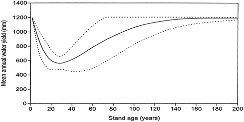
Our understanding of risk was highly coloured by research in Melbourne’s water catchments in the upper Yarra that generated the ‘Kuczera curve’ (Kuczera Citation1987). This curve represents a dynamic ET-streamflow response following fire that results in a streamflow decline over several decades before gradually returning to a pre-fire level (). The published curve depicts a scenario where catchments dominated by old growth obligate seeder ash forests are 100% killed by bushfire and an increase in ET (and decrease in run-off) is driven by high water use by the vigorous, natural post-fire regeneration. The concern around impacts of disturbance on water yield from these forests focusses on the scale of the flow decreased (around 50% at age 25–30), the longevity of the impact and the fact these species dominate the high water yielding catchments. The Kuczera curve is often misunderstood (or misused) given there are relatively few old growth stands remaining in either Melbourne’s water catchments, or the upper catchments of the MDB. Mortality rates post fire can also be variable, meaning that many catchments impacted by fire contain a mix of trees in different age classes. A further complication of applying the Kuczera curve broadly is that most higher rainfall Basin catchments are dominated by non-ash species that are generally not killed by fire, with epicormic shoots resprouting from stems and large branches. The response of these species, ecologically or hydrologically, was not well known, with initial modelling of fire impacts in the early 2000s parameterised these species as much by guesswork as by a solid understanding (see Lane et al. Citation2008, Citation2010; Hill et al. Citation2008). To place this issue in context, only 0.24% of the Basin is vegetated by ash species.
The 2006 Risks report refers to two reports in the wake of the 2003 fires, one of which suggested inflows to the Murray may be reduced by as much as 430 GL by 2020. The other study predicted an initial flow increase of 14–106% for different catchments up until 2010, with subsequent inflow changing by −129 GL to + 4 GL per year. The work noted that the pattern of burn severity and species produce the variable outcomes. The 2006 Risks report does not project fire driven risks into the future, but notes that increased fire is consistent with climate change, and therefore the risk may increase. Clearly the incidence of fire in the broader region has increased significantly since 2006 but these fires have not all impacted on the MDB (). The fire affected area in the Basin since 2000 is around 68,000 Km2 (~6%), with some 21,000 Km2 burnt more than once. It should be noted this analysis does not consider fire severity. The areas depicted in include the upland forest of the southern Basin which are the high water yielding areas.
Figure 1. (a) Fire extent and frequency since 2000 in the Basin, and (b) enlarged version focussed on upland forests.
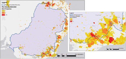
Figure 2. The Kuczera curve (Kuczera Citation1987).
2.2. What we know now?
The key differences in the fire effects were viewed in the Risks Report is our significantly improved understanding of the coupled ecology and hydrology of mixed-species eucalypt forests. These represent most tree species in the Murray-Darling Basin. Fire hydrology in eucalypt forests tended to be clouded by the work of Kuczera (Citation1987) and subsequent studies that produced the distinct age-streamflow response to single age regeneration of the obligate-seeding mountain ash (Eucalyptus regnans) in the decades following the huge 1939 fire. Modelling after the 2003 Victorian fires assumed that the non-ash forests would have a subdued ‘Kuczera effect’ but this was based on an imperfect understanding of mortality rates. We now know that the large-scale mortality seen in ash species does not occur, or is extremely rare, in mixed-species forests. This means the regeneration dynamics and consequent evapotranspiration are different in resprouting mixed species forests than in obligate seeder mountain ash or alpine ash.
Research projects since the mid 2000s indicate:
Far better understanding of the ecological response to fire and importantly, varying levels of fire severity (e.g. Bennett et al. Citation2016; Nolan et al. Citation2014, Citation2015; Fairman, Bennett, and Nitschke Citation2019)
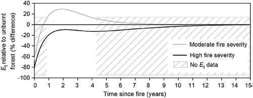
There has been only one study that found there may be flow decreases from mixed species eucalypts (Nolan et al. Citation2015) and that was a function of a uniformly moderate severity in a small experimental catchment – the uniformity of the burn is unusual (.)
All other studies have found either no change in ET or streamflow, or declines in ET and associated flow increases (Heath et al. Citation2014; Gharun, Turrnbull, and Adams Citation2013; Nolan et al. Citation2014; Brown Citation1972; Lane, Sheridan, and Noske Citation2006; Zhou et al. Citation2015; Guo et al. Citation2021). Lane, Sheridan, and Noske (Citation2006) and Guo et al. (Citation2021) found these increases to be substantial; e.g. the former found a 70% increase.
A top-down regional analysis of 92 catchments (Khaledi et al. Citation2022) found that, on average, fire accounted for <9% of streamflow variability, with the signal dominated by rainfall variability. This reduced to 5% in humid catchments, but was 19%–23% for semi-arid areas.
The potential for the largest flow impact remains in ash forests (Brookhouse, Farquhar, and Roderick Citation2013), but there are emerging studies that suggest the eco-hydrologic impact may be very variable (Benyon et al. Citation2023), and any flow dynamics are intrinsically linked to regeneration rates as expressed by self-thinning behaviour, which may not be as uniform as the Kuczera concept suggests. Benyon et al. (in press) proposes that the ‘Kuczera curve’ is one potential outcome, with others far more subdued or even producing flow increases.
The pre- and post fire rainfall and consequent soil moisture storage are important to early post-fire streamflow, and cumulative flow changes. Kuczera (Citation1987) did not identify any flow increases despite the widespread mortaility, nor did Tan, Flower, and Flowers (Citation2011) in the immediate wake of the Black Saturday fires. This is inconsistent with the vast majority of forest disturbance studies (see Brown et al. Citation2005). Modelling by Zhou et al. (Citation2015) reported flow increases in ash catchments after the 1983 Ash Wednesday fires. A key difference between the 1939 (Kuczera) and 2009 (Tan) events and 1983 fires were the length of pre-fire dry period (multiple years for 1939 and 2009) and a single year for 1983. This impact of soil moisture storage volume and post-fire high/low rainfall on streamflow was further explored by Feikema, Sherwin, and Lane (Citation2013).
Species replacement (ash to acacia) can occur when obligate seeder species do not have seed at the time of the fire and fail to regenerate. This results in lower ET and higher streamflow (Lakmali et al. Citation2022).
The potential for ‘flash floods’ driven by small area high intensity convective storms is significant in steep upland forests, but is modulated by topography, soil type and water repellence dynamics – this is also the most important erosion/water quality driver eg. (Nyman, Sheridan, and Lane Citation2013), but is likely to have little impact on catchment-wide streamflow due to the small storm cell size. It is difficult to detect a convective storm input at the larger catchment scale.
Figure 3. ET trajectories following fire in mixed species eucalypt forests (after Nolan et al. Citation2015).
The overall findings from this body of research is that effects of streamflow impacts in the past based on the work of Kuczera (Citation1987) were over-estimated. However, the possibility remains that flows might decrease in ash-dominated catchments if older trees are replaced by rapidly regrowing forest. On the other hand, if high fire frequency means these forests fail to regenerate and species composition changes (for example, see Fairman, Bennett, and Nitschke Citation2019; Nolan et al. Citation2021a) then the hydrology of the system changes (Lakmali et al. Citation2022). This issue of state transitions and impact on water yields was explored by Colloff et al. (Citation2016) who developed and state-and-transition model. This work suggested that there may be significant changes to streamflow from fire-prone catchments if species composition changes.
2.3. Knowledge gaps
The largest knowledge gap in understanding hydrology of forests following fire is the apparent change in fire regime (discussed in more detail below). More frequent fire against a backdrop of intensifying climate mode influence on rainfall has the potential to significantly alter vegetation. shows the extent of multiple burns in <20 years in north-eastern Victoria. Such short fire intervals have driven species replacement, particularly where ash forests are replaced by understorey species, and by marked changes in stand structure (Fairman, Nitschke, and Bennett Citation2016; Fairman, Bennett, and Nitschke Citation2019; Burton et al. Citation2019). The implications for landscape flammability are not well known, nor are the implications for hydrology in mixed species forests. This issue, like many facing the Basin, is highly related to climate dynamics. The state transition concepts proposed by Colloff et al. (Citation2016) should receive greater focus as we grapple with these issues. To date the work of Lakmali et al. (Citation2022) is the only quantitative study of one of these transitions.
2.4. What further research is needed to better quantify and respond to these risks?
We require more work on the feedbacks between climate, fire and vegetation dynamics (see section below). Improved remote sensing of vegetation fire recovery trajectories would give us a much better understanding of how catchments may respond to disturbances caused by fire. While this may not be a ‘risk’ to streamflow, there are significant water quality threats (see Beavis et al. Citation2023) and potential flash flooding where recovery is slow.
3. Fire feedbacks – fire regimes, flammability and vegetation changes?
Fire regimes are broadly defined as the frequency, severity, seasonality and extent of fire, with most ecosystems well-adapted to local historical fire regimes (Gill Citation1975; Turner Citation2010; Whelan Citation1995). Globally, fire regimes are changing in response to changing land-use, climate and fire management strategies (Rogers et al. Citation2020). In SE Australia, there has been an increasing occurrence of ‘mega-fires’, exemplified by the 2019/20 Black Summer fire season where an unprecedented 7.2 Mha of temperate forest was burnt (Boer, Resco de Dios, and Bradstock Citation2020; Bowman et al. Citation2021). In NSW, these fires have contributed to a third of all native vegetation being burnt too frequently, placing this vegetation at potential risk of conversion (Le Breton et al. Citation2022). Similarly, in Victoria large areas have been burnt at higher frequency than historical fire regimes (Fairman, Nitschke, and Bennett Citation2016). There is clear evidence that this increase in fire frequency and fire size in SE Australia is exacerbated by anthropogenic climate change (Abram et al. Citation2021; van Oldenborgh et al. Citation2021).
The implications of increasing fire frequency for vegetation communities, and subsequently for ET, are highly uncertain. For those ecosystems where the dominant tree species are killed by fire, and post-fire recovery occurs via recruitment, repeat fires that occur before seed production can trigger vegetation transitions (Fairman, Nitschke, and Bennett Citation2016). In the MDB, the ash-type forests are most at risk of this (Bowman et al. Citation2016), with an approximately 20-year period required for seed production (von Takach Dukai, Lindenmayer, and Banks Citation2018), although Doherty et al. (Citation2017) found alpine ash flowering at age 8. In the MDB, most forests can resprout after fire, and these forests are less at risk from increased fire frequency, although changing fire regimes combined with climate change may also trigger vegetation transitions.
4. Plantations and revegetation
4.1. What was our understanding of the risk at the time of the CSIRO’s 2006 report
Following a rapid expansion of Australia’s plantation estate in the late 1990s and early 2000s (~820 km2 year−1 nationally between 1996 and 2005) in response to a goal of trebling the commercial plantation area from 1 Mha in 1995 to 3 Mha by 2020, a concern in 2006 was whether widespread conversion from agricultural land to forestry plantations would reduce streamflows in the MDB. This resulted in ‘large-scale plantation forestry’ being identified as an ‘intercepting activity’ in the National Water Initiative (Anonymous Citation2004, paragraph 55,).
An important knowledge gap at the time was what area of new plantations would be established within the MDB and where these would be located. The 2006 ‘Risks to shared water resources…’ report cited an expected increase in plantation area in the MDB of 1410 km2 by 2020 but reported predictions of water yield reductions from the MDB modelled based on increases in plantation area of 4600 and 9200 km2 by 2020, with associated likely long-term reductions in water yield of between 550 and 1400 GL year−1. Reduction in flow resulting from a 1410 km2 increase was not reported but ‘would result in a reduction in water yields of less than 550–700 GL per year’ (van Dijk et al. Citation2006).
In response to these concerns and uncertainties, the National Water Commission funded research to develop ‘Methods to Assess Water Allocation Impacts of Plantations’ (Gilfedder et al. Citation2010) and to improve water accounting and management using remote sensing (SKM Citation2010), while the Murray-Darling Basin Authority sponsored studies of effects of climatic changes on plant physiological and catchment ecohydrological processes in the high-rainfall catchments of the MDB (McVicar et al. Citation2010) and of water availability and ET in the MDB (Roderick and Farquar Citation2011).
4.2. What is our understanding of the risks posed to water yield by plantations now?
While in 2006 our understanding of the hydrological effects of afforestation was not perfect, it was reasonably robust. Our scientific understanding of these effects has changed little since then. Good observed databases are now backed up by models that can be used to predict the likely consequences of afforestation on both annual and seasonal streamflows and how these effects might vary if plantations are located within different parts of a catchment (; Gilfedder et al. Citation2010).
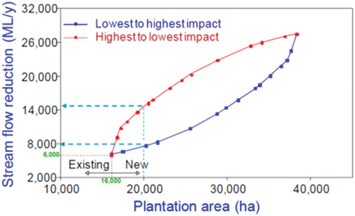
Figure 4. Modelled effect on streamflow of an additional 4000 ha of plantations (an increase from 16,000 to 20,000 ha) in the Adjungbilly catchment in southern NSW, with streamflow reductions varying from 2,000 ML year−1 (lower dashed line) to 8,000 ML year−1 (upper dashed line) depending on location within the catchment. Also shown is the effect of planting the entire catchment, starting either with the lowest impact areas first (blue line) or the highest impact areas first (red line). (Figure ES 2 from Gilfedder et al. Citation2010).
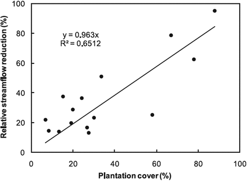
At the time, predictions of changes to streamflow following afforestation in various countries were largely based on small experimental catchment studies that were generalised by Zhang, Dawes, and Walker (Citation2001) into single grassland and forest rainfall:runoff curves. Since then, Zhang et al. (Citation2011) have shown, through a statistical analysis of long-term streamflow trends in 15 small and large catchments in southern Australia, that irrespective of catchment size, the relative streamflow reduction due to afforestation is linearly related to percentage plantation area in a catchment (). There have been some nuanced arguments over the most appropriate model to apply to Australian conditions (Greenwood, Benyon, and Lane Citation2011; Greenwood et al. Citation2014) but broadly speaking the underlying science has changed little.
Figure 5. Observed relationship between percent plantation cover and relative streamflow reduction among 15 small and large (0.6 to 1136 km2) catchments in southern Australia, (from Zhang et al. Citation2011).
Some of the main generalisations we can continue to make with confidence are as follows (see also Keenan et al. Citation2004a, Citation2004b; van Dijk and Keenan Citation2007):
Mean annual runoff from catchments will decrease following land-use change from grass to trees (Bosch and Hewlett Citation1982, Brown et al. Citation2005); the reduction can be reliably estimated using a simple water balance model (Zhang et al. Citation2001) and can be detected in long-term streamflow records in both small and large catchments.
Reduction in mean annual runoff depends on the characteristics of the revegetation carried out and of the vegetation replaced. In south-eastern Australia, pine plantations yield less runoff than native eucalypt plantations, primarily due to the greater interception of rainfall by pines.
Runoff reduction following afforestation is generally proportional to the percentage of tree cover. However, in small experimental catchments it can be difficult to detect a statistically significant change in water yield when less than 20% of the catchment has been afforested. This does not mean, however, that 20% of the landscape can be afforested without reducing water yield.
Groundwater recharge under forest is lower than under pasture and crops and is often close to zero. Hence, plantations can lower water tables, the benefit or detriment from which will depend on the salinity of the groundwater, its potential to contribute to waterlogging or inundation and its potential for productive use.
The rate of groundwater response to afforestation is usually much slower than the rate of runoff response. The discharge response will often lag at least decades behind the reduction in recharge. Afforestation has its greatest impact on absolute runoff in high-rainfall areas, however the greatest proportional reduction is in the low-rainfall areas or at times of low flow.
The number of low or zero flow days is likely to increase following afforestation. Complete afforestation of small headwater catchments with mean annual rainfall of around 900 mm can increase the number of zero-flow days from a range of 0–50 to a range of 175–225 days per year.
Runoff reductions are minor for the first 5 years after afforestation and are often greatest 10–20 years after planting.
Water yields from forests may slowly increase after 30 years of age as water use starts to decline in association with reduced growth rate.
Forest thinning and forest clearing can lead to increased water yield, the magnitude of increase depending on the proportion of the forest cleared and the age of the trees.
What else we know now about water use of plantations and woody vegetation in southern and eastern Australia and the MDB?:
From 2007 to 2010, research on plantation water use in the MDB focused on applying more detailed process-based models to various case-study catchments to better account for the local factors affecting changes in ET and annual and seasonal streamflow/groundwater recharge after afforestation (Gilfedder et al. Citation2010). This research suggested that location of afforestation within catchments can substantially modify their effects on water yield (Figure P1). Research also aimed to separate the effects on streamflows of recent climate change from effects of higher ET due to afforestation and showed that important effects of both could be identified in long-term streamflow records and were independent of scale (e.g. Zhang et al. Citation2011).
Research on plantation water use in areas with shallow groundwater has shown that pine and eucalypt plantations have similar water use once the canopy has closed and both species can use low salinity groundwater where it is accessible to tree roots in a transmissive, unconfined aquifer (Benyon et al. Citation2006, Citation2009, Citation2012, Benyon and Doody Citation2015). This research was used in licencing of commercial plantations for recharge interception and groundwater use in the Lower Limestone Coast GMA of south east SA. Outside of South Africa, this is the only place in the world where plantation water use has been regulated (Greenwood Citation2013).
Since 2009 there has been increased focus on using satellite-based remote sensing to map spatial variation in ET (Guerschmann et al. Citation2009, SKM Citation2010). Satellite-based and modelling studies have also looked at natural ‘woody thickening’ due to elevated CO2 and climate change and its effect on ET (Macinnis-Ng et al. Citation2011).
One study quantified the possibility of saving water (reducing ET) by removing woody weeds, especially willows from streams in the MDB (Doody and Benyon Citation2011; Doody et al. Citation2014).
What has changed most since 2006 is our understanding of the likely rate of plantation development in the MDB and the drivers of afforestation within the basin. As Zhang et al. (Citation2011) demonstrated, the most important variable determining the hydrological impacts of plantations is the percentage of a catchment converted from grassland to trees. At the time, the report was prepared in 2006, only a small proportion of new plantation development was in the MDB (from 1996 to 2005 only ~35,000 ha out of 822,000 ha (4.3%) of new plantations across Australia) (van Dijk et al. Citation2007). Almost 1 million ha of new plantations were established up to 2008, mostly in southern Western Australia, Victoria and Tasmania, with small areas in NSW, Queensland and the Northern Territory. Since then, few new plantations have been established and changes in economic drivers have seen conversion of plantations back to agriculture. Plantations have also been impacted by bushfires. These have mainly been replanted. The national total commercial plantation estate in 2019–20 was 1.77 Mha (), down 10% from its 2014–15 estimate (Legg, Frakes, and Gavran Citation2021). A relatively small proportion of the intensive agriculture area of about 67 million ha.
The extent of plantations is clearly considerably lower than expected under the 2020 objective set back in the 1990s, with little change in the extent of plantations in the Basin since 2005. The areas shown in represent 375,805 ha., some 0.3% of the Basin area. Forest industry and government have put forward a recent target of 400,000 ha. of commercial plantations distributed across the current zones of timber industry activity (Australian Government Citation2018) but little progress has been made towards this target.
Figure 6. Plantation and carbon plantings and vegetation protection in the Basin. Note that the planting and protected area under the emissions reduction fund are approximate and the shading denote property boundaries rather than the actual area of planting. The plantation areas are from 2016 data (https://www.awe.gov.au/abares/forestsaustralia/forest-data-maps-and-tools/spatial-data/australias-plantations).
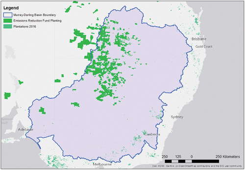
While the expansion of commercial forestry plantations no longer seems to be the major risk to water availability in the MDB that was perceived in 2006, new drivers may result in establishment of larger areas of woody vegetation with potential to increase ET. In particular, establishment of trees and other woody vegetation for ecological restoration and environmental services, including investment in carbon offsets (). Landcare and environmental plantings have been occurring in the basin since the 1980s, often with the specific goal of reducing streamflow and water tables to reduce salinity and improve water quality. Carbon offset plantings have been occurring under various government and voluntary carbon project programmes since the early 2000s. These have been spread around the country, with some in the Basin (), mostly in western NSW and Queensland in avoided deforestation and human induced regeneration (HIR) projects in the northern parts of the Basin (Evans Citation2018). Since 2014 the bulk of carbon investment has been through the AUD$2.55 billion Emissions Reduction Fund (Australian Government Citation2022), with voluntary purchases operating within the Carbon Farming Initiative framework expanding rapidly. Farmers are also looking to plant more trees on farms to meet carbon neutrality objectives for their farm operation.
The hydrological consequences of revegetation and carbon farming are uncertain; however, we can make the following observations:
Projects that do not result in net change in vegetation (e.g. Avoided deforestation) will have no net impact on ET over time. Land clearing rates are declining across Australia, so this is likely to have less effect on catchment hydrology in future.
Most afforestation and revegetation projects are in lower rainfall areas, which do not contribute a large portion of water yield to the MDB.
Concerns about potential impacts of large-scale revegetation on water use have been incorporated in climate policy. Changes to some policy constraints have recently been proposed (e.g. https://consult.dcceew.gov.au/proposed-removal-of-water-rule-requirements), but regulators are conscious of potential risks and are likely to implement policy to prevent adverse water impacts if scale develops in regions of concern.
Larger-scale carbon investments are unlikely to occur in large blocks and cover whole catchments. They are more likely to be in smaller plantings at farm scale. The challenge for investment in these projects will be the financial mechanisms to aggregate these plantings to enable larger-scale investment.
4.3. What are the knowledge gaps that should be addressed to best inform the revision of the Murray-Darling basin plan 2026?
There are two important questions related to forest cover and ET in the MDB: (1) how and where is the woody vegetation cover in the basin changing? (increases due to more plantations, revegetation and woody thickening versus losses due to land clearing, drought death, dieback and fires); (2) more generally for all woody vegetation in the MDB, how are rising CO2 and associated climate changes affecting the proportion of precipitation that becomes evapotranspiration?
There is, therefore, a need to change the focus from single issues such as plantation expansion, which can be important locally (e.g. rapid afforestation of a particular catchment), but low risk to the MDB as a whole, to examining net changes in woody vegetation cover over the entire basin and the relationship between potential evapotranspiration (ETp), actual evapotranspiration (ETa) and precipitation (P) from existing permanent forests, especially in the high water-yielding parts of the basin. Of non-irrigated land uses, conversion of grassland to forest has the greatest impact per unit of land area converted, but more widespread changes in agricultural land use may also have important impacts. Changes from annual pastures to perennial pastures or crops, for example, are expected to have relatively small impacts on evapotranspiration per unit of land area, but if undertaken on a large scale could have important influences on hydrology, especially on groundwater recharge. While this has been identified as an issue in the past, and attempts have been made to quantify and predict the impacts of various agricultural land use changes in some catchments (e.g. Clifton, Daamen, and Horne Citation2005), particularly in relation to dry-land salinity (e.g. Vaze et al. Citation2004), there appears to have been little new research on the subject in Australia in the past 15 years. It is, however, something that needs to be considered in monitoring long-term changes in the water balance of the MDB.
4.4. What further research is needed to better quantify and respond to these risks?
Remote sensing of woody vegetation cover change and evapotranspiration.
Studies of ET responses to rising CO2 and climate change in the more common forest types, especially in the high water-yielding parts of the basin.
Improved accounting for vegetation change (i.e. land clearing, carbon and environmental plantings.
Improved hydrologic modelling of the more water limited areas of the Basin that incorporate vegetation change.
5. Climate change and vegetation interactions
An element crucial to all afforestation/deforestation scenarios is how temperature increases, rainfall decreases and C02 enrichment will play out in evapotranspiration dynamics. The higher evaporative demand via higher temperature and vapour pressure deficits should lead to increased ET in forested landscapes. However, the effect of rising C02 may lead to higher water use efficiency (WUE). For example, Raupach, Havered, and Briggs (Citation2013) modelled climate scenarios for the whole of Australia and concluded that for cool temperate regions, higher temperatures and higher CO2 would effectively cancel each other out. There have been a limited number of studies on the effect of CO2 enrichment on eucalypts, but given the challenges in observing these responses, there remains a non-unified understanding. The Climate paper in this issue (Alexandra, Citation2023, this issue) will look at climate in detail. Here we discuss some aspects relevant to vegetation dynamics, functioning and ET.
5.1. What was our understanding of the risk at the time of the CSIRO’s 2006 report ?
While climate change was identified as one of the risks to water resources in the MDB, the identified risks were direct, i.e. changes in rainfall and potential evapotranspiration. However, climate change is expected to have indirect consequences on water resources through effects on vegetation structure, composition and function
5.2. What is our understanding of the risk now?
The implications of the direct effects of reduced rainfall and higher evaporative demand have, if anything, sharpened, or at least been more closely matched with regional water resources (e.g. CSIRO Citation2012; DELWP, Bureau of Meteorology, CSIRO and University of Melbourne Citation2020; DELWP Citation2020). Alexandra (Citation2023) considers these issues in depth, however it is salient to note that streamflow reductions of up to 50% are considered possible for some areas (e.g. southwest Victoria, DELWP, Bureau of Meteorology, CSIRO and University of Melbourne Citation2020). These rainfall/runoff dynamics are not confined to changes in mean annual values but include the implications of changing rainfall regimes (i.e. greater rainfall intensities/lower duration) and rainfall and streamflow extremes (Khaledi et al. Citation2022). Notably, there is a body of evidence that shows some catchments in Victoria have not recovered from the Millennium Drought (Saft et al. Citation2015; Peterson et al. Citation2021). These are mostly in drier regions and therefore have a large effect on local water availability. However, in terms of total flow, it is the upland forested catchments in the Upper Murray that have the potential for the largest effect on overall flows. These are the high rainfall areas supporting high water using forests. The ET dynamics under future climates will be crucial in understanding how streamflow will vary.
The research in the past 15 years on climate–ET interactions includes studies that model streamflow responses and those with a greater emphasis on ecophysiological processes. A common thread in the results from the ET-streamflow modelling of C02 effects is a diversity of system responses, particularly in terms of the water-energy balance. Cheng et al. (Citation2014) predicted a small runoff increase in energy limited forests, but an increase in ET and decreases in runoff for water limited forests and grassland, and energy limited grassland. The WUE gains in the latter three catchments were supplanted by increased growth and consequent increased ET. Ukkola et al. (Citation2016) found no CO2 effect in wet or dry catchments, but significant increases in ET and decreases in streamflow in sub-humid and semi-arid catchments, due to increased greening from CO2 fertilisation. This is consistent with Cheng et al. (Citation2014), with similar results reported from Roderick and Farquar (Citation2011). Ukkola et al. (Citation2016) found that the precipitation threshold for water limitation had changed significantly in the previous three decades in the sub-humid systems.
Eucalypt forests across the MDB are resilient to inter-annual variations in climate, including rainfall. For example, during the prolonged Millennium Drought, there was no evidence of widespread dieback of forests (De Kauwe et al. Citation2020), although Mac Nally et al. (Citation2011) reported declines in riverine forests and Bergstrom et al. (Citation2021) suggested these forests were on the verge of collapse. Further, experimental studies have shown that eucalypts can maintain transpiration rates during heatwaves which contributes to evaporative cooling, and limits thermal damage (Drake et al. Citation2018; Griebel et al. Citation2020). However, some species may maintain transpiration rates under extreme drought, at the risk of incurring failure of the hydraulic system and subsequent tissue death (Marchin et al. Citation2022). When drought is coupled with heat waves, substantial canopy die-back may occur in eucalypts. This was observed during the 2019/20 drought where large areas of forest were subject to canopy die-back (De Kauwe et al. Citation2020; Nolan et al. Citation2021b). Widespread canopy dieback during this drought, but not the Millennium drought, may have been due to the nature of the drought. The drought event in 2019/20 has been described as a ‘flash drought’, i.e. a rapid intensification of drought conditions over a few weeks (Nguyen et al. Citation2021). Additionally, temperatures were the highest on record (Abram et al. Citation2021). The rapid intensification of the drought, combined with record high temperatures, led to soil moisture and foliar moisture conditions that were the lowest observed on record (Abram et al. Citation2021).
Climate change may also impact on suitable areas for plantations. A study by SMEC (Citation2010) indicated that a drier climate may result in 9.7% less inflows to the MDB and a contraction of plantations to rainfall zones that receive greater than 800 mm y-1 mean annual rainfall. End-of-system flow under could reduce end of system flows by 25% across the Basin, with possible decreases of 69% in the driest areas. Compared to these changes, the estimated reduction in end-of-system flow of 0.8% attributable to a project 52,000 ha increase in plantations was small and likely to be even lower given there has been limited plantation expansion in the region to date. Changes in forests in response to climate change such as in vegetation seasonality, rooting depth, depth of rain penetration in soil, and responses to increased CO2 may partially offset effects of new forests on stream flow (SMEC Citation2010).
A long-term Free Air CO2 Enrichment (FACE) study has examined effects of elevated CO2 on growth and water use in dry-sclerophyll Eucalyptus forest and suggests that in low nutrient soils, the CO2 fertilisation effect would not reduce ET of natural dry sclerophyll eucalypt forests in eastern Australia (e.g. Gimeno et al. Citation2018). However, the effects of rising CO2 and climate change on growth and water use of natural forests in the wetter parts of the MDB and in Australia’s main plantation species are poorly studied.
5.3. Knowledge gaps
It is highly uncertain what impacts forest canopy dieback due to severe droughts and heatwaves will have on forests, since many eucalypts can resprout after complete defoliation (Nicolle Citation2006). For example, Saintilan et al. (Citation2022) argue that the stress reported by Bergstrom et al. (Citation2021) was a standard physiological response to water stress, and recovery and even expansion of riverine forests have occurred since the Millennium Drought. Subsequent impacts on ET are therefore also highly uncertain. However, we expect that loss of vegetation cover and transition to alternative vegetation states may lead to an initial decrease in ET, similar to forest removal. As alternative vegetation states emerge, longer-term trends in ET are highly uncertain.
Under climate change, elevated CO2 has been predicted to lead to improved water-use-efficiency in vegetation, with plants needing to transpire less water for the same unit of carbon gain (Morison Citation1985). However, despite decades of research there are still considerable uncertainties as to whether elevated CO2 manifests in ‘water savings’ for plants, due in part to complex responses of plants to water stress (De Kauwe, Medlyn, and Tissue Citation2021). Further, uncertainties arise since forests may increase leaf area in response to elevated CO2, ameliorating any water savings (Tor-Ngern et al. Citation2015). Further, some forests may not respond to elevated CO2 due to constraints such as nutrient limitation (Jiang et al. Citation2020).
Some broader questions on the effects of afforestation and deforestation and on the effects of climate change on forest health and ET may also be relevant to the MDB:
Increasing drought frequency and severity may increase forest drought deaths, which will usually reduce ET and increase streamflow (Adams et al. Citation2012). Is this happening in the MDB and if so, at what scale?
Broadscale changes in forest cover modulate energy and water fluxes: removal of forests reduces ET and increases land surface temperatures. One study estimated that between 2003 and 2012, variations of forest cover globally produced warming on land equal to ~18% of the global biogeochemical signal due to CO2 emission from land-use change (Alkama and Cescatti Citation2016; Zeng et al. Citation2018). Increased woody vegetation cover and increased ET might cool other parts of the landscape, reduce ET at a landscape scale and potentially increase regional precipitation. For example, Gohr et al. (Citation2021) found substantial cooling effect on hot days of forests and wetlands in northern Germany with their increasing share of land cover. In a broad scale study across the US, Li et al. (Citation2021) found forest loss increased surface albedo, decreased ET, and reduced leaf area index (LAI) resulting in increased annual warming in the arid/semiarid, northern, tropical, and temperate regions, dominated by the warming from decreased ET and attenuated by the cooling from increased albedo.
What is the effect of wet periods on forest and woodlands? How much do wet periods buffer both vegetation and the catchments, and how might that change spatially?
5.4. What further research is needed to better quantify and respond to these risks?
Any discussion or quantification of vegetation water use must include climate drivers. Some of these are direct (rainfall, temperature, vapour pressure deficit, wind), but others are compounded effects. Fire events are intimately connected to climate via usually prolonged or intense dry periods, as is fire regime dynamics (warming and drying climate driving a change to fire regimes). However, the post-fire ET-streamflow is of course highly connected to the rainfall and evaporative demand. There have been studies that seek to separate the fire and climate effects (Guo et al. Citation2021; Nolan et al. Citation2015), and Lane et al. (Citation2010) compared fire and climate change scenarios (which showed climate to be a larger effect that stand replacing fire). However, there is much still to learn about how these interactions play out in a process sense. For example, what level of water stress causes trees to become more likely to die in a fire? Does the pre-fire water status influence recovery at the tree and stand scale? Whether a ‘Kuczera effect’ occurs or not is linked to stand regeneration dynamics, but what drives the regeneration trajectory?
While the foregoing is centred on fire, similar questions arise for any eco-hydrologic question. The system feedbacks, particularly driven by the climate drivers, are likely to be important for vegetation systems. These are, however, not easy to evaluate. Further, there is the issue of scale of some of the research. Small catchment experiments are excellent for tying physiographic properties (e.g. vegetation and soils) and climate forcings to hydrologic responses. However, the extent to which these can be scaled up across the diversity of landscape properties contained in the Basin is a significant question.
6. Discussion and conclusions
Overall, this review has not revealed any one factor in forests, fire and forest management that poses a serious risk to the Basin water resources, but the potential for interactive impacts, mainly driven by climate dynamics exist. Both fire and afforestation effects on ET and streamflow were probably overblown at the time of the 2006 report and for a few years after. This is in no way a criticism of the 2006 Risks report – the government policies pushing plantation expansion and the uncertainty around fire effects outside of ash forests were clear risks.
The largest uncertainties in predicting ET – streamflow from forested and woody landscapes in the Basin are related to climate. The upland forests of the southern Basin are particularly important in streamflow generation. The higher rainfall areas of these forests are energy limited. C02 fertilisation may not produce much more growth in these systems, allowing the increased WUE to compensate for higher temperatures. However, the interactions are not well understood, and more uncertainty is attached to fire effects on vegetation structure. It seems that the drier forests may be more at risk from temperature effects. Again, hydraulic regulation or increased mortality may compensate for increased evaporative demand. Climate models are predicting changed rainfall patterns. How this plays out in the future may well have important interactions with ET. The cool season rainfall decreases evident in Victorian catchments has had a significant impact on streamflow, and there are predictions of less rain days but more intense rainfall in warmer times of the year. Plant water availability, and extent and intensity of future bushfires, may be affected by these changed rainfall distributions. Increased extent and ET of woody vegetation may also lead to higher regional rainfall, but this effect needs further study in Australia and the MDB.
A further illustration of the complexities of understanding hydrologic interactions is research that has shown some catchments have not recovered from the Millennium Drought (Saft et al. Citation2016; Peterson et al. Citation2021), exhibiting persistent changes to rainfall-runoff ratios. While there is a forming census that the principal process at play is hydraulic disconnection (i.e. the vadose zone has become disconnected from streams) (Fowler et al. Citation2022), the interaction of other factors such as increasing evaporative demand and possible greening of vegetation in response to C02 enrichment may be contributing.
We do not think there are specific policy options that are required. To a large extent the policy levers are either the bigger picture climate changes issues (emission reduction) or the market-based influences on plantation expansion or contraction. Certainly, improved quantification of afforestation through carbon and environmental plantings would be useful, but in many instances the changes to the water balance may not be sufficient to alter Basin flows.
In summary, we suggest that the risks to the Basin’s water have not increased because of either fire or afforestation, but that there are many uncertainties related to the interplay of vegetation, climate and fire and the compounding effects of these drivers. There is a need for models that are able to adequately represent the heterogeneity in, soils, vegetation, extraction and impoundment points, and downscaled climate inputs that include the full distribution of rainfall events.
Acknowledgements
The authors would like to thank Laura Matthews for help with figures and GIS analysis, and the anonymous reviewers for their work in improving the paper.
Disclosure statement
No potential conflict of interest was reported by the authors.
Additional information
Notes on contributors
Patrick NJ Lane
Patrick Lane is a Professor of Forest Hydrology in the School of Ecosystem and Forest Sciences, University of Melbourne. His research interests include the ecohydrology of natural and disturbed forests, streamflow dynamics and erosion processes. He has a particular interest in the effect of fire and climate variability on forest functioning and hydrology.
Richard G Benyon
Richard Benyon is a Principal Research Fellow in Forest Hydrology at the University of Melbourne. His research is focused on measuring and modelling evapotranspiration in natural, disturbed and planted forests, including effects of climate variability and change, wildfire and land use change.
Rachael H Nolan
Rachael Nolan is a Senior Research Fellow at the Hawkesbury Institute for the Environment at Western Sydney University. Her research focuses on the role of disturbances in ecosystems, in particular the effects of fire on forest ecosystem services.
Rod J Keenan
Rodney Keenan is Professor and Chair of Forest and Ecosystem Sciences at the University of Melbourne. He has research interests in sustainable forest management, forests and climate change, ecosystem services and forest policy.
Lu Zhang
Lu Zhang is an Honorary Fellow with CSIRO Environment. His research interests include ecohydrology, evapotranspiration, impacts of vegetation on catchment water balance, and ecosystem response to climate change.
References
- Abram, NJ., BJ. Henley, A. Sen Gupta, TJR. Lippmann, H. Clarke, AJ. Dowdy, JJ. Sharples, et al. 2021. “Connections of Climate Change and Variability to Large and Extreme Forest Fires in Southeast Australia.” Communications Earth & Environment 2 (1): 8. doi:10.1038/s43247-020-00065-8.
- Adams, HD., CH. Luce, DD. Breshears, CD. Allen, M. Weiler, Hale VC Smith Ams, and TE. Huxman. 2012. “Ecohydrological Consequences of Drought- and Infestation Triggered Tree Die-Off: Insights and Hypotheses.” Ecohydrology 5 (2): 145–159. doi:10.1002/eco.233.
- Alexandra, J. 2023. “Climate Risk Assessment in the MDB – a Review.” Australasian Journal of Water Resources 1–13. doi:10.1080/13241583.2022.2157107.
- Alexandra, J., and L. Rickards. 2021. “The Contested Politics of Drought, Water Security and Climate Adaptation in Australia’s Murray-Darling Basin.” Water Alternatives 14 (3): 773–794.
- Alkama, R., and A. Cescatti. 2016. “Biophysical Climate Impacts of Recent Changes in Global Forest Cover.” Science 351 (6273): 600–604. doi:10.1126/science.aac8083.
- Anonymous. 2004. “Intergovernmental Agreement on a National Water Initiative Between the Commonwealth of Australia and the Governments of New South Wales, Victoria, Queensland, South Australia, the Australian Capital Territory and the Northern Territory.” 39. www.awe.gov.au.
- Australian Government. 2018. “National Forest Industries Plan.” www.agriculture.gov.au/agriculture-land/forestry/national-forest-industries-plan
- Australian Government. 2022. “Emissions Reduction Fund.” https://www.cleanenergyregulator.gov.au/ERF/About-the-Emissions-Reduction-Fund
- Beavis, SG., VNL. Wong, LM. Mosely, DS. Baldwin, JO. Latimer, PNJ. Lane, and A. Lal. 2023. “Water Quality Risks in the Murray-Darling Basin.” Australasian Journal of Water Resources doi:10.1080/13241583.2022.2163475.
- Bennett, LB., MJ. Bruce, J. MacHunter, M. Kohout, MA. Tanase, and C. Aponte. 2016. “Mortality and Recruitment of Fire-Tolerant Eucalypts as Influenced by Wildfire Severity and Recent Prescribed Fire.” Forest Ecology and Management 380: 107–117. doi:10.1016/j.foreco.2016.08.047.
- Benyon, RG., and TM. Doody. 2015. “Comparison of Interception, Forest Floor Evaporation and Transpiration in Pinus Radiata and Eucalyptus Globulus Plantations.” Hydrological Processes 29 (6): 1173–1187. doi:10.1002/hyp.10237.
- Benyon, RG., TM. Doody, S. Theiveyanathan, and V. Koul. 2009. “Plantation Forest Water Use in Southwest Victoria.” Forest and Wood Products Australia, Project No. PNC064-0607, Melbourne: FWPA.
- Benyon, RG., A. Inbar, GJ. Sheridan, CS. Lyell, and PNJ. Lane. 2023. “Variable Self-Thinning Explains Hydrological Responses to Stand Replacement in Even-Aged Forests.” Journal of Hydrology 618: 129157. doi:https://doi.org/10.1016/j.jhydrol.2023.129157.
- Benyon, RG., PNJ. Lane, S. Theiveyanathan, TM. Doody, and PJ. Mitchell. 2012. “Spatial Variability in Forest Water Use from Three Contrasting Regions of South-Eastern Australia.” Acta horticulturae 951 (951): 233–238. doi:10.17660/ActaHortic.2012.951.28.
- Benyon, RG., S. Theiveyanathan, and TM. Doody. 2006. “Impacts of Tree Plantations on Groundwater in South-Eastern Australia.” Australian Journal of Botany 54 (2): 181–192. doi:10.1071/BT05046.
- Bergstrom, D., B C. Wienecke, J. Hoff, L. Hughes, D B. Lindenmayer, T D. Ainsworth, C M. Baker, et al. 2021. “Combating Ecosystem Collapse from the Tropics to the Antarctic.” Global Change Biology 27 (9): 1692–1703. doi:10.1111/gcb.15539.
- Boer, MM., V. Resco de Dios, and R. Bradstock. 2020. “Unprecedented Burn Area of Australian Mega Forest Fires.” Nature Climate Change 10 (3): 171–172. doi:10.1038/s41558-020-0716-1.
- Bosch, J M., and JD. Hewlett. 1982. “A Review of Catchment Experiments to Determine the Effect of Vegetation Changes on Water Yield and Evapotranspiration.” Journal of Hydrology 55 (1–4): 3–23. doi:10.1016/0022-1694(82)90117-2.
- Bowman, D., GJ. Williamson, OF. Price, MN. Ndalila, and RA. Bradstock. 2021. “Australian Forests, Megafires and the Risk of Dwindling Carbon Stocks.” Plant, Cell & Environment 44 (2): 347–355. doi:10.1111/pce.13916.
- Bowman, DMJS., GJ. Williamson, LD. Prior, and BP. Murphy. 2016. “The Relative Importance of Intrinsic and Extrinsic Factors in the Decline of Obligate Seeder Forests.” Global Ecology and Biogeography 25 (10): 1166–1172. doi:10.1111/geb.12484.
- Brookhouse, MT., GD. Farquhar, and MT. Roderick. 2013. “The Impact of Bushfires on Water Yield from South-East Australia’s Ash Forests.” Water Resources Research 49 (7): 4493–4505. doi:10.1002/wrcr.20351.
- Brown, JAH. 1972. “Hydrologic Effects of a Bushfire in a Catchment in South - Eastern New South Wales.” Journal of Hydrology 15: 77–96. doi:10.1016/0022-1694(72)90077-7.
- Brown, A., L. Zhang, TA. McMahon, AW. Western, and RA. Vertessy. 2005. “A Review of Paired Catchment Studies with Reference to the Seasonal Flows.” Journal of Hydrology 310 (1–4): 28–61. doi:10.1016/j.jhydrol.2004.12.010.
- Burton, J., J. Cawson, P. Nsoke, and G. Sheridan. 2019. “Shifting States, Altered Fates: Divergent Fuel Moisture Responses After High Frequency Wildfire in an Obligate Seeder Eucalypt Forest.” Forests 10 (5): 436. doi:10.3390/f10050436.
- Canadell, JP., CP. Meyer, GD. Cook, A. Dowdy, PR. Briggs, J. Knauer, A. Pepler, and V. Haverd. 2021. “Multi-Decadal Increase of Forest Burned Area in Australia is Linked to Climate Change.” Nature Communications 12 (1): 6921. doi:https://doi.org/10.1038/s41467-021-27225-4.
- Cheng, L., L. Zhang, Y-P. Wang, Q. Yu, D. Eamus, and A. O’grady. 2014. “Impacts of Elevated CO2, Climate Change and Their Interactions on Water Budgets in Four Different Catchments in Australia.” Journal of Hydrology 519: 1350–1361. doi:10.1016/j.jhydrol.2014.09.020.
- Clifton, C., C. Daamen, and A. Horne. 2005. “Water and Land Use Change Study: Changes in Hydrology and Flow Stress with Land-Use Change in South-West Victoria.” Final Technical Report, June 2005, Glenelg Hopkins CMA, Hamilton, Victoria.
- Colloff, M.J., M.D. Doherty, S. Lavorel, M. Dunlop, R.M. Wise, and S.M. Prober. 2016. “Adaptation Services and Pathways for the Management of Temperate Montane Forests Under Transformational Climate Change.” Climatic Change 138 (1–2): 267–282. doi:10.1007/s10584-016-1724-z.
- CSIRO. 2012.Climate and water availability in south-eastern Australia: A synthesis of findings from Phase 2 of the South Eastern Australian Climate Initiative (SEACI). 41. Australia: CSIRO. September 2012.
- De Kauwe, MG., BE. Medlyn, and DT. Tissue. 2021. “To What Extent Can Rising [CO2] Ameliorate Plant Drought Stress?” The New Phytologist 231 (6): 2118–2124. doi:10.1111/nph.17540.
- De Kauwe, MG., BE. Medlyn, AM. Ukkola, M. Mu, MEB. Sabot, AJ. Pitman, P. Meir, et al. 2020. “Identifying Areas at Risk of Drought-Induced Tree Mortality Across South-Eastern Australia.” Global Change Biology 26 (10): 5716–5733. doi:10.1111/gcb.15215.
- DELWP. 2020. Guidelines for Assessing the Impact of Climate Change on Water Availability in Victoria. Published November 2020.
- DELWP, Bureau of Meteorology, CSIRO and University of Melbourne. 2020. Victoria’s Water in a Changing Climate. Insights from the Victorian Water and Climate Initiative. The State of Victoria Department of Environment, Land, Water and Planning. ISBN 978-1-76105-349-8.
- Doherty, MD., AM. Gill, GJ. Cary, and MP. Austin. 2017. “Seed Viability of Early Maturing Alpine Ash (Eucalyptus Delegatensis Subsp. delegatensis) in the Australian Alps, South-Eastern Australia, and Its Implications for Management Under Changing Fire Regimes.” Australian Journal of Botany 65 (7): 517–523. doi:10.1071/BT17068.
- Doody, T., and R. Benyon. 2011. “Quantifying Water Savings from Willow Removal in Australian Streams.” Journal of Environmental Management 92 (3): 926–935. doi:10.1016/j.jenvman.2010.10.061.
- Doody, TM., RG. Benyon, T. Theiveyanathan, V. Koul, and L. Stewart. 2014. “Development of Pan Coefficients for Estimating Evapotranspiration from Riparian Woody Vegetation.” Hydrological Processes 28 (4): 2129–2149. doi:10.1002/hyp.9753.
- Drake, JE., MG. Tjoelker, A. Vårhammar, BE. Medlyn, PB. Reich, A. Leigh, S. Pfautsch, et al. 2018. “Trees Tolerate an Extreme Heatwave via Sustained Transpirational Cooling and Increased Leaf Thermal Tolerance.” Global Change Biology 24 (6): 2390–2402. doi:10.1111/gcb.14037.
- Evans, MC. 2018. “Effective Incentives for Reforestation: Lessons from Australia’s Carbon Farming Policies.” Current Opinion in Environmental Sustainability 32: 38–45. doi:10.1016/j.cosust.2018.04.002.
- Fairman, TA., LT. Bennett, and CR. Nitschke. 2019. “Short Interval Wildfire Increase Likelihood of Resprouting Failure in Fire-Tolerant Trees.” Journal of Environmental Management 231: 59–65. doi:10.1016/j.jenvman.2018.10.021.
- Fairman, TA., CR. Nitschke, and LT. Bennett. 2016. “Too Much, Too Soon? A Review of the Effects of Increasing Wildfire Frequency on Tree Mortality and Regeneration in Temperate Eucalypt Forests.” International Journal of Wildland Fire 25 (8): 831–848. doi:10.1071/WF15010.
- Feikema, PM., CB. Sherwin, and PNJ. Lane. 2013. “Influence of Climate, Fire Severity and Forest Mortality on Predictions of Long Term Streamflow: Potential Effect of the 2009 Wildfire on Melbourne’s Water Supply Catchments.” Journal of Hydrology 488: 1–16. doi:10.1016/j.jhydrol.2013.02.001.
- Fletcher, MS., A. Romano, C. Connor, M. Mariani, and SY. Maezumi. 2021. “Catastrophic Bushfires, Indigenous Fire Knowledge, and Reframing Science in Southeast Australia.” Fire 4 (3): 61. doi:10.3390/fire4030061.
- Fowler, K., M. Peel, M. Saft, TJ. Peterson, A. Western, L. Band, C. Petheram, et al. 2022. “Explaining Changes in Rainfall–Runoff Relationships During and After Australia’s Millennium Drought: A Community Perspective.” Hydrology and Earth System Sciences 26 (23): 6073–6120. doi:https://doi.org/10.5194/hess-26-6073-2022.
- Gharun, M., TL. Turrnbull, and MA. Adams. 2013. “Stand Water Use Status in Relation to Fire in Mixed Species Eucalypt Forest.” Forest Ecology and Management 304: 162–170. doi:10.1016/j.foreco.2013.05.002.
- Gilfedder, M., L. Zhang, T. Theiveyanathan, N. Marcar, S. Roxburgh, M. Littleboy, F. Zhao, Y. Chen, A. Almeida, and D. Crawford. 2010. Methods to Assess Water Allocation Impacts of Plantations: Final Report. 15. CSIRO: Water for a Healthy Country National Research Flagship.
- Gill, AM. 1975. “Fire and the Australian Flora. A Review.” Australian Forestry 38 (1): 4–25. doi:10.1080/00049158.1975.10675618.
- Gimeno, TE., TR. McVicar, AP. O’grady, DT. Tissue, and D.S. Ellseworth. 2018. “Elevated CO2 Did Not Affect the Hydrological Balance of a Mature Native Eucalyptus Woodland.” Global Change Biology 24 (7): 3010–3024. doi:10.1111/gcb.14139.
- Gimeno, TE., TR. McVicar, AP. O’grady, DT. Tissue, and DS. Ellsworth. 2018. “Elevated CO2 Did Not Affect the Hydrological Balance of a Mature Native Eucalyptus Woodland.” Global Change Biology 24 (7): 3010–3024. doi:10.1111/gcb.14139.
- Gohr, C., JS. Blumroder, D. Shiel, and PL. Ibisch. 2021. “Quantifying the Nature of Mitigation of Temperature Extremes by Forests and Wetlands in a Temperate Landscape.” Ecological Informatics 66: 66. doi:10.1016/j.ecoinf.2021.101442.
- Greenwood, AJB. 2013. “The First Stages of Australian Forest Water Regulation: National Reform and Regional Implementation.” Environmental Science & Policy 29: 124–136. doi:http://dx.doi.org/10.1016/j.envsci.2013.01.012.
- Greenwood, AJB., RG. Benyon, and PNJ. Lane. 2011. “A Method for Assessing the Hydrological Impact of Afforestation Using Regional Mean Annual Data and Empirical Rainfall–Runoff Curves.” Journal of Hydrology 411 (1–2): 49–65. doi:10.1016/j.jhydrol.2011.09.033.
- Greenwood, AJB., G. Schoups, EP. Campbell, and PNJ. Lane. 2014. “Bayesian Scrutiny of Simple Rainfall–Runoff Models Used in Forest Water Management.” Journal of Hydrology 512: 344–365. doi:http://dx.doi.org/10.1016/j.jhydrol.2014.01.074.
- Griebel, A., LT. Bennett, D. Metzen, E. Pendall, PNJ. Lane, and SK. Arndt. 2020. “Trading Water for Carbon: Maintaining Photosynthesis at the Cost of Increased Water Loss During High Temperatures in a Temperate Forest.” Journal of Geophysical Research Biosciences 125 (1): e2019JG005239. doi:10.1029/2019JG005239.
- Guerschman, JP., AIJM. Van Dijk, G. Mattersdorf, J. Beringer, LB. Hutley, R. Leuning, RC. Pipunic, and BS. Sherman. 2009. “Scaling of Potential Evapotranspiration with MODIS Data Reproduces Flux Observations and Catchment Water Balance Observations Across Australia.” Journal of Hydrology 369 (1–2): 107–119. doi:10.1016/j.jhydrol.2009.02.013.
- Guo, Y., L. Zhang, Y. Zhang, Z. Wang, and H X. Zheng. 2021. “Estimating Impacts of Wildfire and Climate Variability on Streamflow in Victoria, Australia.” Hydrological Processes 35 (12): e14439. doi:10.1002/hyp.14439.
- Heath, JT., CJ. Chafer, FF. van Ogtrop, and TFA. Bishop. 2014. “Post-Wildfire Recovery of Water Yield in the Sydney Basin Water Supply Catchments: An Assessment of the 2001/2002 Wildfires.” Journal of Hydrology 519: 1428–1440. doi:10.1016/j.jhydrol.2014.09.033.
- Hill, P I., A. Mordue, R J. Nathan, C C. Daamen, K. Williams, and R E. Murphy. 2008. “Spatially Explicit Modelling of the Hydrologic Response of Bushfires at the Catchment Scale.” Australian Journal of Water Resources 12 (3): 281–290. doi:10.1080/13241583.2008.11465354.
- Jiang, MK., BE. Medlyn, JE. Drake, RA. Duursma, IC. Anderson, CVM. Barton, MM. Boer, et al. 2020. “The Fate of Carbon in a Mature Forest Under Carbon Dioxide Enrichment.” Nature 580 (7802): 227–231. doi:10.1038/s41586-020-2128-9.
- Keenan, RJ., A. Gerrand, S. Nambiar, and M. Parsons. 2004b. Plantations and Water: Plantation Impacts on Stream Flow. Science for Decision Makers. Canberra, ACT: Bureau of Rural Sciences, Dept. of Agriculture, Fisheries and Forestry.
- Keenan, R., M. Parsons, A. Gerrand, E. O’loughlin, S. Beavis, D. Gunawardana, M. Gavran, and A. Bugg. 2004a. Plantations and Water Use: A Review Prepared for the Forest and Wood Products Research and Development Corporation. Canberra: Bureau of Rural Sciences.
- Khaledi, J., PNJ. Lane, CR. Nitschke, and P. Nyman. 2022. “Wildfire Contribution to Streamflow Variability Across Australian Temperate Zone.” Journal of Hydrology 609: 127728. doi:10.1016/j.jhydrol.2022.127728.
- Khaledi, J., CR. Nitschke, PNJ. Lane, TP. Penman, and P. Nyman. 2022. “The Influence of Atmosphere-Ocean Phenomenon on Water Availability Across Temperate Australia.” Water Resources Research 58 (1): e2020WR029409. doi:10.1029/2020WR029409.
- Kuczera, GA. 1987. “Prediction of Water Yield Reduction Following a Bushfire in Ash-Mixed Species Eucalypt Forest.” Journal of Hydrology 94 (3–4): 215–236. doi:10.1016/0022-1694(87)90054-0.
- Lakmali, S., RB. Benyon, GJ. Sheridan, and PN.J. Lane. 2022. “Change in Fire Frequency Drives a Shift in Species Composition in Native Eucalyptus Regnans Forests: Implications for Overstorey Forest Structure and Transpiration.” Ecohydrology 15 (3). doi:10.1002/eco.2412.
- Lane, PNJ., PM. Feikema, CB. Sherwin, MC. Peel, and A. Freebairn. 2010. “Modelling the Long Term Water Yield Impact of Wildfire and Other Forest Disturbance.” Environmental Modelling and Software 25 (4): 467–478. doi:10.1016/j.envsoft.2009.11.001.
- Lane, PNJ., PJ. Sheridan, and PJ. Noske. 2006. “Changes in Sediment Loads and Discharge from Small Mountain Catchments Following Wildfire in South Eastern Australia.” Journal of Hydrology 331 (3–4): 495–510. doi:10.1016/j.jhydrol.2006.05.035.
- Lane, PNJ., CB. Sherwin, MC. Peel, and AC. Freebairn. 2008. “Impact of the 2003 Alpine Bushfires on Streamflow - Predicting the Long-Term Impacts of Bushfire on Water Yield.” MDBC Publication No 24 (08): 54.
- Le Breton, TD., MB. Lyons, RH. Nolan, T. Penman, G. Williamson, and MKJ. Ooi. 2022. “Megafire-Induced Interval Squeeze Threatens Vegetation at Landscape Scales.” Frontiers in Ecology and the Environment 20 (5): 327–334. doi:10.1002/fee.2482.
- Legg, P., I. Frakes, and M. Gavran. 2021. Australian Plantation Statistics and Log Availability Report 2021. ABARES research report. Canberra, October. doi:10.25814/xj7c-p829.
- Li, Y., Y. Liu, G. Bohrer, Y. Cai, A. Wilson, T. Hu, Z. Wang, and K. Zhou. 2021. “Impacts of Forest Loss on Local Climate Across the Conterminous United States: Evidence from Satellite Time-Series Observations.” The Science of the Total Environment 802: 149651. doi:10.1016/j.scitotenv.2021.149651.
- Macinnis-Ng, C., M. Zeppel, M. Williams, and D. Eamus. 2011. “Applying a SPA Model to Examine the Impact of Climate Change on GPP of Open Woodlands and the Potential for Woody Thickening.” Ecohydrology 4 (3): 379–393. doi:10.1002/eco.138.
- Mac Nally, R., S C. Cunningham, P J. Baker, G J. Horner, and J R. Thomson. 2011. “Dynamics of Murray-Darling Floodplain Forests Under Multiple Stressors: The Past, Present, and Future of an Australian Icon.” Water Resources Research 47 (12): W00G05. doi:10.1029/2011WR010383.
- Marchin, RM., D. Backes, A. Ossola, MR. Leishman, MG. Tjoelker, and DS. Ellsworth. 2022. “Extreme Heat Increases Stomatal Conductance and Drought-Induced Mortality Risk in Vulnerable Plant Species.” Global Change Biology 28 (3): 1133–1146. doi:10.1111/gcb.15976.
- McVicar, TR., RJ. Donohue, AP. O’grady, and LT. Li. 2010. “The Effects of Climatic Changes on Plant Physiological and Catchment Ecohydrological Processes in the High-Rainfall Catchments of the Murray-Darling Basin: A Scoping Study.” CSIRO: Water for a Healthy Country National Research Flagship 95 pp.
- Milly, PCD. 1994. “Climate, Soil Water Storage and the Annual Water Balance.” Water Resources Research 30 (7): 2143–2156. doi:10.1029/94WR00586.
- Morison, JIL. 1985. “Sensitivity of Stomata and Water Use Efficiency to High CO2.” Plant, Cell & Environment 8 (6): 467–474. doi:10.1111/j.1365-3040.1985.tb01682.x.
- Nguyen, H., MC. Wheeler, HH. Hendon, EP. Lim, and JA. Otkin. 2021. “The 2019 Flash Droughts in Subtropical Eastern Australia and Their Association with Large-Scale Climate Drivers.” Weather and Climate Extremes 32: 100321. doi:10.1016/j.wace.2021.100321.
- Nicolle, D. 2006. “A Classification and Census of Regenerative Strategies in the Eucalypts (Angophora, Corymbia and Eucalyptus—Myrtaceae), with Special Reference to the Obligate Seeders.” Australian Journal of Botany 54 (4): 391–407. doi:10.1071/BT05061.
- Nolan, RH., L. Collins, A. Leigh, MKJ. Ooi, TJ. Curran, TA. Fairman, V. Resco de Dios, and R. Bradstock. 2021a. “Limits to Post-Fire Vegetation Recovery Under Climate Change.” Plant, Cell & Environment 44 (11): 3471–3489. doi:10.1111/pce.14176.
- Nolan, RH., A. Gauthey, A. Losso, BE. Medlyn, R. Smith, SS. Chhajed, K. Fuller, et al. 2021b. “Hydraulic Failure and Tree Size Linked with Canopy Die-Back in Eucalypt Forest During Extreme Drought.” The New Phytologist 230 (4): 1354–1365. doi:10.1111/nph.17298.
- Nolan, RH., PNJ. Lane, RB. Benyon, R. Bradstock, and PJ. Mitchell. 2014. “Changes in Evapotranspiration Following Wildfire in Resprouting Eucalypt Forests.” Ecohydrology 7: 1363–1377. doi:10.1002/eco.1463.
- Nolan, RH., PNJ. Lane, RB. Benyon, R. Bradstock, and PJ. Mitchell. 2015. “Trends in Evapotranspiration and Streamflow Following Wildfire in Resprouting Eucalypt Forests.” Journal of Hydrology 524: 614–624. doi:10.1016/j.jhydrol.2015.02.045.
- Nyman, P., GJ. Sheridan, and PNJ. Lane. 2013. “Hydro-Geomorphic Response Models for Burnt Areas and Their Applications in Hazard Prediction and Land Management.” Progress in Physical Geography 37 (6): 787–812. doi:10.1177/0309133313508802.
- O’Toole, K., and M. Keneley. 2010. “Forgotten Outcomes for Rural Areas in Central Policy‐Making: The Case of Blue Gums in Australia.” Australian Journal of Public Administration 69 (2): 190–201. doi:10.1111/j.1467-8500.2010.00683.x.
- Peterson, TJ., M. Saft, M. Peel, and A. John. 2021. “Watersheds May Not Recover from Drought.” Science 372 (6543): 745–749. doi:10.1126/science.abd5085.
- Raupach, MJ., V. Havered, and PR. Briggs. 2013. “Sensitivities of the Australian Terrestrial Water and Carbon Balances to Climate Change and Variability.” Agricultural and Forest Meteorology 182-183: 277–291. doi:10.1016/j.agrformet.2013.06.017.
- Roderick, MJ., and GD. Farquar. 2011. “A Simple Framework for Relating Variations in Runoff to Variations in Climatic Conditions and Catchment Properties.” Water Resources Research 47 (12): W00G07. doi:10.1029/2010WR009826.
- Rogers, BM., JK. Balch, SJ. Goetz, CER. Lehmann, and M. Turetsky. 2020. “Focus on Changing Fire Regimes: Interactions with Climate, Ecosystems, and Society.” Environmental Research Letters 15 (3): 030201. doi:10.1088/1748-9326/ab6d3a.
- Saft, M., MC. Peel, AW. Western, and L. Zhang. 2016. “Predicting Shifts in Rainfall-Runoff Partitioning During Multi-Year Drought: Roles of Dry Period and Catchment Characteristics.” Water Resources Research 52 (12): 9290–9305.
- Saft, M., L. Zhang, AW. Western, MC. Peel, and NJ. Potter. 2015. “The Influence of Multiyear Drought on the Annual Rainfall-Runoff Relationship: An Australian Perspective.” Water Resources Research 51 (4): 2444–2463. doi:10.1002/2014WR015348.
- Saintilan, N., E. Asbridge, R. Lucas, K. Rogers, L. Wen, M. Powell, and MJ. Colloff. 2022. “Australian Forested Wetlands Under Climate Change: Collapse or Proliferation?” Marine & Freshwater Research 73 (10): 1255–1262. doi:10.1071/MF21233.
- SKM. 2010. “Assessment of Water Use Across the Murray-Darling Basin Using SEBAL Remote Sensing Technology.” Report to the National Water Commission.
- SMEC. 2010. Afforestation Risks to Water Resources in the Murray-Darling Basin. Canberra: Murray-Darling Basin Authority.
- Tan, KS., DJM. Flower, and DM. Flowers. 2011. “An event runoff coefficient approach for assessing changes in short-term catchment runoff following bushfires.” 34th IAHR World Congress - Balance and Uncertainty, Brisbane 26 June – 1 July 2011, pp 1522–1529.
- Tor-Ngern, P., R. Oren, EJ. Ward, S. Palmroth, and HR. McCarthy. 2015. “Increases in Atmospheric CO 2 Have Little Influence on Transpiration of a Temperate Forest Canopy.” The New Phytologist 205 (2): 518–525. doi:10.1111/nph.13148.
- Turner, MG. 2010. “Disturbance and Landscape Dynamics in a Changing World.” Ecology 91 (10): 2833–2849. doi:10.1890/10-0097.1.
- Ukkola, AM., C. Prentice, TF. Keenan, AIJM. van Dijk, NR. Viney, RB. Myneni, and J. Bi. 2016. “Reduced Streamflow in Water-Stressed Climates Consistent with CO2 Effects on Vegetation.” Nature Climate Change 6 (1): 75–78. doi:10.1038/nclimate2831.
- van Dijk, AIJM., HE. Beck, RS. Crosbie, RAM. de Jeu, YY. Liu, GM. Podger, R. Timbal, and NR. Viney. 2013. “The Millennium Drought in Southeast Australia (2001–2009): Natural and Human Causes and Implications for Water Resources, Ecosystems, Economy, and Society.” Water Resources Research 49 (2): 1040–1057. doi:10.1002/wrcr.20123.
- van Dijk, Albert, Ray Evans, Peter Hairsine, Shahbaz Khan, Rory Nathan, Zahra Paydar, Neil Viney, and Lu Zhang. 2006. “Risks to the Shared Water Resources of the Murray-Darling Basin, Part II in a Two Part Series on the Shared Water Resources of the Murray-Darling Basin Prepared for the Murray-Darling Basin Commission.” Murray-Darling Basin Commission, Canberra MDBC Publication No 22/06 ISBN 1: 921038 88 8.
- van Dijk, AIJM., PB. Hairsine, JP. Arancibia, and TI. Dowling. 2007. “Reforestation, Water Availability and Stream Salinity: A Multi-Scale Analysis in the Murray-Darling Basin, Australia.” Forest Ecology and Management 251 (1–2): 94–109. doi:10.1016/j.foreco.2007.06.012.
- van Dijk, A.I.J.M., and R.J. Keenan. 2007. “Planted Forests and Water in Perspective.” Forest Ecology and Management 251 (1–2): 1–9. doi:10.1016/j.foreco.2007.06.010.
- van Oldenborgh, GJ., F. Krikken, S. Lewis, NJ. Leach, F. Lehner, KR. Saunders, M. van Weele, et al. 2021. “Attribution of the Australian Bushfire Risk to Anthropogenic Climate Change.” Natural Hazards and Earth System Sciences Discussion 2020: 1–46.
- Vaze, J., P. Barnett, G. Beale, W. Dawes, R. Evans, NK. Tuteja, B. Murphy, G. Geeves, and M. Miller. 2004. “Modelling the Effects of Land-Use Change on Water and Salt Delivery from a Catchment Affected by Dryland Salinity in South-East Australia.” Hydrological Processes 18 (9): 1613–1637. doi:10.1002/hyp.1409.
- von Takach Dukai, B., DB. Lindenmayer, and SC. Banks. 2018. “Environmental Influences on Growth and Reproductive Maturation of a Keystone Forest Tree: Implications for Obligate Seeder Susceptibility to Frequent Fire.” Forest Ecology and Management 411: 108–119. doi:10.1016/j.foreco.2018.01.014.
- Whelan, RJ. 1995. ‘The Ecology of Fire.’. Cambridge, UK): Cambridge University Press.
- Zeng, Z., S. Piao, LZ. Li, T. Wang, P. Ciais, X. Lian, Y. Yang, J. Mao, X. Shi, and B. Myneni. 2018. “Impact of Earth Greening on the Terrestrial Water Cycle.” Journal of Climate 31 (7): 2633–2650. doi:10.1175/JCLI-D-17-0236.1.
- Zhang, L., WR. Dawes, and GR. Walker. 2001. “Response of Mean Annual Evapotranspiration to Vegetation Changes at Catchment Scale.” Water Resources Research 37 (3): 701–708. doi:10.1029/2000WR900325.
- Zhang, L., F. Zhao, Y. Chen, and RNM. Dixon. 2011. “Estimating Effects of Plantation Expansion and Climate Variability on Streamflow for Catchments in Australia.” Water Resources Research 47 (12). doi:10.1029/2011WR010711.
- Zhou, Y., Y. Zhang, J. Vaze, P. Lane, and S. Xu. 2015. “Impact of Bushfire and Climate Variability on Streamflow from Forested Catchments in Southeast Australia.” Hydrological Sciences Journal 60 (7–8): 1340–1360. doi:10.1080/02626667.2014.961923.