
 ?Mathematical formulae have been encoded as MathML and are displayed in this HTML version using MathJax in order to improve their display. Uncheck the box to turn MathJax off. This feature requires Javascript. Click on a formula to zoom.
ABSTRACT
In 2016, the Chinese government raised community opening policy for the first time. In order to study the effects of spatial anticrime in open communities, five quantifiable evaluation indexes are selected, which are “flow density, police deployment distance, spatial visibility, anti-capture ability and spatial connectivity”. They are applied to the quantitative analysis of the spatial anticrime performance of two different building layouts in open community in China. The spatial anticrime analysis model from the perspective of crime prevention is practical and feasible, which is of avail for the police to check up the physical environment vulnerable to crime in advance, and to carry out preliminary prevention from the causes of crime. The empirical study shows that both “Determinant” and “Enclosed” Community layout have their own advantages and disadvantages. Overall, the spatial structure of determinant is safer than the enclosed spatial structure, but the partial safety is lower due to the obstruction of sight and insufficient pedestrian flow in the narrow space between some buildings. The enclosed layout structure has higher safety in the interior space of the community space group, but lower safety factor on the main roads. Finally, the corresponding security promotion strategies are proposed for these two communities.
1. Introduction
The urban planning policy of “open community” was put forward in the decree for the first time by the State Council of the People’s Republic of China in 2016. The policy points out that in order to promote the intensive land use, the “Narrow streets and dense network” should be gradually promoted in the future for the new unit communities in China, and in principle, new applications for closed uptowns will be no longer accepted (China Citation2016). The concept of open community originated from the “fusion residential community”, which integrates with urban functional space, contributing to the sharing of urban public infrastructure, creating a dynamic urban atmosphere and improving urban functions. The policy has provoked widespread discussions in all sectors of society (Yao et al. Citation2018; Yu Citation2017), and the issue of situational crime prevention and control brought about by community opening has become the focus of heated discussion in all sectors of society (Zhang, Qin, and Zhu Citation2019).
In the process of urbanization, social issues and various negative factors in the environment lead to high crime rate in urban communities (Desmond, Papachristos, and Kirk Citation2016; Brook et al. Citation2011; Takizawa, Koo, and Katoh Citation2010). In addition to the convenience of access, it also increases the complexity of traffic conditions and composition of people coming and going, after a unit community is open. These changes will exacerbate the community resident’s sense of insecurity. The analysis of the relationship between the crime rate and the spatial pattern of the community has become the main challenge faced by the scholars in criminal geography and urban planning (Tang et al. Citation2017). Empirical research shows that there is a significant correlation between urban crime and community spatial environment (Marzbali et al. Citation2016; Peeters and Vander Beken Citation2017; Yue et al. Citation2018). Later, people use statistical analysis tools to achieve more accurate results on the relationship between the incidence of community space crime and spatial environment (Tang et al. Citation2017). However, limited to the government’s requirements for the confidentiality of criminal data, there are few achievements in the study of the distribution of crime in urban residential areas in China.
1.1. Overview of study
Spatial anticrime theory mainly discusses the influence of community spatial environment on criminal behaviour. By reinforcing and transforming the areas with high crime incidence, the probability of crime occurrence can be reduced by ways of increasing the degree of difficulty factor, increasing the risk of arrest, and reducing the benefit of crime (Clarke Citation1997). Thus, the focus of crime prevention strategies is shifted from social factors to material environmental factors, which makes crime prevention research measures practical and feasible. At the same time, this means effectively reduces the cost of crime prevention, which has been adopted by large number of countries in the world (Xu Citation2003). On the basis of extensive research, three basic theories have been put forward, namely, Routine Activity Theory (RAT), Rational Choice Theory (RCT), and Environmental Criminology.
The Routine Activity Theory was first proposed by Lawrence Cohen and Marcus Felson in 1979 (Cohen and Felson Citation1979). This theory explained criminal behaviours from the perspective of criminal conditions. The conditions of daily criminal behaviour include three elements: “Potential Criminals”, “the Suitable Targets”, and “Lack of Effective Supervisors”. Among them, “the Suitable Targets” should meet the following characteristics: value, visibility, accessibility, and mobility. Taylor found that if there are too many active people in the community, it is easy to bring too many criminal targets and thus enhance the possibility of crime (Taylor Citation2002).
The theory of rational choice emphasizes the subjective initiative of criminal subject. It holds that the criminal is a rational person who can make a careful judgment, and the criminal act is a decision made by the criminal after his rational thinking about the benefit and loss of the criminal act. The theory of rational choice is put forward by Clarke and Felson in the premise of “rational economic man hypothesis”. There are two basic elements, one is opportunity, the other is choice. When the criminal’s judgment on the environment meets the requirement that the income is greater than zero, it is possible to commit a crime (Wang Citation2005).
The theory of environmental criminology transfers the reasoning of the crime from the subject of the crime to the objective environment and focuses its research on the space-time environment. In the early stage, Jeffery put forward the theory of “crime prevention through environmental design” (CPTED) in 1971 (Jeffery Citation1977), which believed that the reasonable design and effective use of urban physical space could reduce the probability of criminal behaviour and assuage the residents’ fear of criminal behaviour. Then Oscar Newman further developed on this basis and put forward the theoretical concept of “defensible space” (Newmam Citation1978). This theory is highly valued and widely spread because it pays attention to the transformation of material space to enhance the sense of community security. Jacobs put forward the street eye theory, pointing out the importance of natural monitoring to the safety construction of residential areas (Jacobs Citation1961; Fuller and Moore Citation2017); Lee and soyeon pointed out the impact of visibility on children’s safety in the campus (Lee and Ha Citation2015, Citation2016). Weisel D. l pointed out that the channel control had a certain impact on the crime rate of burglary in residential areas (Weisel Citation2004).
It can be concluded that the theoretical and empirical analysis of the environmental characteristics of criminal acts has achieved fruitful results in the world. The research perspective runs through social and physical factors, and the content of social factors such as population structure which influence the distribution of potential criminals and victims (Kauzlarich and Barlow Citation2009; Shaw and McKay Citation1972; Rupp et al. Citation2019), flow density (Rupp et al. Citation2019), policing distance (변성수 and 배민기 Citation2019) and so on; physical environmental factors include environmental visibility (Fujii, Fujikawa, and Oikawa Citation2013), space permeability (Cozens Citation2008), access control ability (Weisel Citation2004) and environmental aesthetics (Roh and Park Citation2017), which provide an effective basis for the prediction of urban internal crime in this paper.
1.2. Comparison between technologies
The theoretical research of urban community crime prevention is accompanied by a variety of technical applications. The initial application of technology originated from the demand of statistics. In the early 1920s, New York City police began to use chromatic “pin” to represent the distribution of different types of cases on the base map, in order to find the law of crime zone. Then with the development of computer and geographic information technology (GIS), the research of criminal geography has been further based on computer positioning and display development. In the 21st-century information age, the wide application of GPS positioning technology and big data has brought more new development opportunities to the statistics of criminal geography. For example, through the network monitoring, data can better locate the crime place in the city, and combined with the real-time monitoring and reporting technology, greatly improve the efficiency of police work and detection of cases. However, most of the above-mentioned technical research focuses on the technical analysis of macro statistics, which lacks a certain pertinence for the statistics of crime occurrence within the community level.
Then people’s research perspective gradually turned to the micro-level and reached the community scale level. The micro-level analysis changes people’s research perspective from the macro regularity of the statistical crime place to a series of mechanisms that are easy to cause crime within the community. In this level of analysis, “spatial syntax”, as an important theoretical basis for the study of spatial morphology and spatial perception, has been proposed and fully applied. The development and application of this theory in technology mainly include Depth Map and related plug-in Axwoman combined with ArcGIS. In addition to technical analysis at the spatial level, research at the social factor level has also developed synchronously, and some new research technologies or approaches have been proposed and applied gradually. Research methods such as “perceptual map” and “Questionnaire” are widely used, while related technologies of social statistics, such as AHP (analytic hierarchy process) and multi-factor line region method, are also applied to the prediction of the inducement of crime in the community, which greatly improves the judgment of crime and the accuracy and pertinence of land.
However, in the existing research, the micro-level technical analysis still stays in a single space or social element analysis and has not yet explored the correlation between the spatial and social level of crime induction mechanism. As of May 2019, there are only 6 research articles with the theme of “space syntax” and “crime” in the core collection of Web of Science, and only 1 article with “community” in abstract (Hillier and Sahbaz Citation2005). Thus, the advantages of space syntax in interpreting space security have not been well explored, by using which the empirical research on interpreting open communities still needs to be further expanded and discussed. On the basis of the research and analysis of community-level security prevention and control, this paper will take the method of combining space-time elements and social elements to rate and grade the level of community internal prevention and control. In addition, the data collection will be combined with the network lbs big data, which will improve the accuracy of data, and provide a new technical solution for community prevention and control.
1.3. Objectives of this research
In view of this, from the perspective of anticrime, we attempt to analyze the crime prevention and control of urban communities based on extensive research and empirical theories. This paper analyzes and selects the spatial and social factors that influence the formation of crime from empirical analysis, selects those indicators that can be quantified, and makes an empirical interpretation of the established open community in China, aiming to provide effective guidance for the later construction. The main objectives of this study are:
Establish a quantitative analysis model that can be used for safety prevention and control analysis, which can enrich the existing theories and methods of crime prevention and control.
Summarize the advantages and disadvantages of determinant layout and group layout in time dimension and space dimension, respectively, from the results, providing effective evidence for the future safety construction of open communities in China.
2. Materials and methods
2.1. Subjects
China has experienced rapid population growth during the past few years. In order to alleviate the pressure of city housing, high-rise buildings are widely used in the construction of habitations. Cluster high-rise buildings have become the trend of housing construction in China. In the densely populated area of the city, the layout of the building complex can be mainly divided into two types: “determinant” and “enclosure”. The former presents a “streamlined” structure, which is characterized by a “multi centre” activity site outwards, while the latter is often used by the designers who prefer to a “central command” structure, forming a lot of “internal centripetal” spaces ().
Figure 1. Community A of determinant layout and community B of enclosed layout
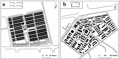
Since China’s open community is still in the stage of exploration and construction, there are few cases especially those that meet the actual opening up of “main roads inside the community”, such as Beijing Huaqing Jiayuan Residential District, Shanghai Chunshen Vanke City, Chengdu No.1 Block, etc. First of all, a preliminary screening is carried out for these cases, the main purpose of this step is to select the communities that can obviously reflect the two layout patterns, and then further examine the urban location and population structure of these communities to make sure that the two cases finally selected are similar in these aspects. Finally, we selected the eligible communities A and B as the research object of this paper.
Community A’s building shape and direction are relatively uniform, in line with the deterministic layout structure. It is located near the fourth ring road in the central area of second-tier cities in central China. It has a large total population and a moderate overall population density. Community B is formed by multiple internal groups of buildings, presenting the structural characteristics of the enclosed community. It is located between the third ring and the fourth ring of second-tier cities in central and western China and has a moderate regional population density. There is much comparability between the controlling factors of Communities A and B, especially the layout and population structure.
2.2. Experimental design
Considering the complexity of the factors involved in this research, we used weighted superposition analysis (SAW) in order to make the data available for effective analysis. The indicators come from various influencing factors in the theory of crime prevention (Clarke Citation1997), which are mainly divided into two parts: social indicators and environmental indicators.
Social indicators include population structure (distribution of potential criminals and victims) (Kauzlarich and Barlow Citation2009; Shaw and McKay Citation1972; Rupp et al. Citation2019), community flow density (Rupp et al. Citation2019), police deterrent strength (변성수 and 배민기 Citation2019), and other factors. Indicators that can be used for data processing are selected as follows:
Using community flow density and police deterrent strength as social indicators, and other factors as invariants.
Establishing spatial environmental indicators mainly including spatial visibility (Fujii, Fujikawa, and Oikawa Citation2013), permeability (Cozens Citation2008), intensity of access control (Weisel Citation2004), and environmental aesthetics (Roh and Park Citation2017), among which quantitative visibility, permeability, and intensity of access control are also selected for analysis.
Combining with the anticrime section, respectively, the above five selected indicators are named as flow density (corresponding to community flow density), police deployment distance (corresponding to police fortification intensity), spatial visibility (corresponding to visibility), anti-capture ability (corresponding to intensity of access control) and spatial connectivity (corresponding to space permeability). We selected the quantitative data sources of the five indicators, detailed in . And in the last two columns of , it points out the processing method of later data and the positive or negative contribution to the anticrime evaluation. The “+” in the table indicates that the index value is positively related to the safety performance. The larger the value obtained from the analysis, the higher the community safety, the less likely to cause crime. On the contrary, the “-” represents that the larger the value of the analysis result, the lower the community safety prevention and control performance, the more likely to cause crime, and the lower the residents’ sense of safety. Overall, see for the final stacking process.
Figure 2. Overlapping process graph
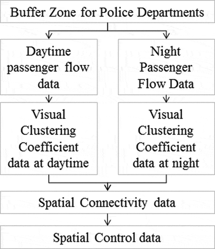
Table 1. Evaluation index system
2.3. Data acquisition: base map
The overlay base map was derived from OSM (Open Street Map). After obtaining the four spatial coordinates of community A and community B, we imported them into OSM to get the latest base map data. Then, by aid of actual geographic image, the acquired geographic data was matched and calibrated, and closed road boundaries were marked. In order to carry out the spatial analysis of visibility and permeability with Depth Map software, further, we drew the enclosure interface of building outline, green planting boundary line, structures affecting the vision of the community, and other invisible factors. In the base map of night visible layer, according to the actual visit of the community, the space visibility of the main road was reserved, and the visibility of the branch road with insufficient illumination in the community was removed. Finally, we got a more complete base map of community space analysis.
2.4. Experiment1: flow density
Tencent’s “Easy to Go” software can be used for data crawling and processing. As open source data, the “Easy to Go” software provides an API data interface for developers and researchers to obtain data. Besides, it has a large customer base and can reflect the real-time flow data within the community to a certain extent. In order to obtain the flow change data, with writing the corresponding Python code and setting the collection time to 2 H/time, we obtained 12 groups of flow data with coordinate positioning within one working day (24 h) in March 2019. The repeated data were removed according to the result of the data testing and cleaning. Finally, we got four original data including longitude and latitude coordinates, time, and crowd coordinates.
After adding the stream data collected by Python to the ArcGIS content panel, we transformed the X and Y data in the data to geographic coordinates which were converted into Shapefiles after this step.
In order to facilitate the subsequent nuclear density analysis, we transformed the coordinates to the projection coordinate system corresponding to WGS 1984 and then analyzed the flow and density of people. The calculation formula that we used is as follows:
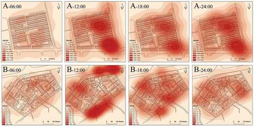
In formula (1), f(s) represents the density function of s point, h is the minimum value of distance attenuation, and K is the weight value of distance from I to s point. In order to ensure the accuracy of the study, the accuracy of the spatial distribution model within the street scale was controlled at 2.5 m, and a total of 12 drawings within a working day were obtained based on the data from different sources. The darker the colour in the area, the more concentrated the population distribution ().
Figure 3. Core density analysis of community real-time flow
2.5. Experiment2: police deployment distance
Based on collected POI (Point of Interest) data within 1 km around the community in the map of Gaud, 5 effective policing points around community A and 4 effective policing points around community B are obtained. After importing the data derived from the above step into ArcGIS software, we used the buffer analysis tool to analyse the deterrence of the police station. The buffer zone was set to five levels. According to experts’ opinions:
0–50 m was set to the level of 5, representing a strong deterrent force.
50–100 m was set to the level of 4 with a strong deterrent force.
100–200 m was the level of 3 with a strong deterrent force.
200–500 m was set to the level of 2 with a certain deterrent force.
500-1000 m was the level of 1, with a slight deterrent force.
By making use of Depth Map software to deal with community spatial visibility layer and accessible layer, respectively, we analyzed the spatial visibility, anti-capture ability, and spatial connectivity and read the visual clustering coefficient, control value, and connectivity value. The corresponding calculation formulas of these three indicators are shown in . Then the data were exported after analysis to the format of TXT data, and imported into ArcGIS software for processing.
Table 2. Formulas for calculating spatial syntactic variables
2.6. Experiment3: weighted analysis
We put the above analysis data into ArcGIS layer and then used SAW to overlay analysis. AHP was used to set the weight value according to questionnaire from eight experts, including associate professors in urban planning and landscape architecture fields, police officers, and community residents. In order to avoid some individual unreasonable scores which might lead to the overall value deviation, the consistency ratio (CR) was used to test the results. After testing, the consistency of the model matrix is 0.0843, less than 0.1, which meets the requirements of the consistency test. Therefore, the above expert scoring data can be used as a reference for weight in this experimental model. Finally, with these steps, we got the weight values in .
Table 3. Weight value of indicators
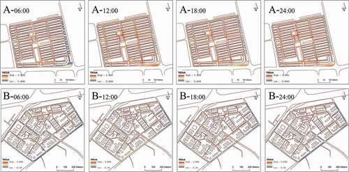
In view of the different distribution of values in the above layers, the difference between floating-point and integer values is too large, so it is necessary to reclassify the data. The data were reclassified by Natural Breaks (Jenks), which was set to nine levels. After that, the corresponding weight value of each layer data was given, and the formal analysed layers were superposed in turn, and a total of 24 drawings of A and B communities were finally obtained. Eight valid drawings from them are selected for display ().
Figure 4. Safety assessment map of open community
3. Results
3.1. Holistic analysis result
In terms of time mode,12 timing nodes of open communities A and B (measured every two hours, time periods are 02:00, 04:00, 06:00, …, 24:00) were selected as inspection time to analyze and interpret the 12 evaluation figures about the effects of anticrime. In the resulting map, the red color depth is proportional to the value and the security level of community open space which is inversely proportional to the blue color depth. It means that violent crime is more likely in the community in low security level. The results of the overall analysis and comparison show that the blue areas of community A and B are significantly higher than that of the daytime and the evening during 24:00–04:00 at night, and 02:00 and 04:00 in the morning are the two time when the blue area is most widely distributed in the whole day; in the daytime layer, 12:00, 16:00, and 18:00 are the three time when the warm color area occupying the main position of the community space, and the value also reaches the peak within the whole day in this time period.
Based on the situational variables in the formation of the crime behaviours, time mechanism can affect community security mainly from two factors:
Firstly, with the change of time, the real-time flow density in the community will change significantly, reflected in the difference in the amount of LBS real-time positioning data obtained ().
Table 4. The ratio of real-time personnel flow to maximum personnel flow in community A and community B
Secondly, the change of time has an impact on the visibility of community interior space, and the difference between the light radiation intensity of sunlight and night lighting will also lead to the change of community interior space safety.
shows the changes in the flow and density of people in communities A and B over daytime. To ensure the confidentiality of data, we divided the overall flow of people by a certain coefficient. As can be seen from the changes in the line chart, the flow of people in communities was low from 02:00 to 06:00 in the morning, and the natural monitoring by residents in the community was insufficient, which meant the sense of security is low. The peak value of pedestrian flow occurred from 10:00 a.m. to 12:00 a.m. at this time, the pedestrian flow in the community was the largest, and the local density reached the peak value of the whole day in this period.
In the spatial pattern, community A and B have their own specificity. Overall, the safety of the main longitudinal road in community A is higher than that of other secondary roads and branches in the community. It can be found based on the comparing data of the overlaid figures of each layer. This is mainly because the main road has the strongest visibility in the community. At the same time, the centre of the road has set up a special police department, which has a good supervision and control on the site. In contrast, community B is different from community A in that the safety of the primary open road in the community is not high. Combined with overlay layer analysis, the reason is that the value of connectivity of the road is too high, which gives the lawbreakers a great chance to escape when they commit crimes and increases the probability of their success, thus reducing the level of space security (Sohn Citation2016). On the contrary, due to the proper distribution of people flow and the local high control ability, the overall safety level of the internal branches in the community has been improved.
Base on the above analysis, it can be concluded that:
The safety of main roads in the community is affected by the specific community structure, and the main influencing factors are visibility and connectivity of the roads.
Some branches with high control force in the community have high security.
The surrounding police deployment has no decisive impact on community safety, but places such as supermarkets and farmers’ markets which have a greater impact on the flow of people have a high impact on the improvement of safety.
3.2. Comparative analysis result
Judging from the results of the data calculation, the anticrime value of community A with the determinant layout is in the range of [- 3.28, 3.10], while the anticrime value of community B with the enclosed layout is distributed in the range of [- 3.13, 2.50]. It can be concluded that the maximum value of community A is 0.6 higher than that of community B. It means that there is a much safer space in community A for anticrime in the final weighted calculation than community B, which corresponds to the space surrounding government agencies in community A. There are several reasons accounting for it. First, the space surrounding the agencies is at the end of the central axis of the road. And it is comparatively open, so that the area has strong spatial visibility and high value of connectivity, increasing the local social residents’ flows. While the safest space of community B is mainly distributed in the branch road between community groups, and there is a rising trend of security at the intersection of some main roads. In terms of the distribution of areas vulnerable to crime, community A is mainly distributed on the roads between residential buildings, and the narrower the sidewalk is, the higher the unsafe attribute value is. The reason is that the actual pedestrian flow in the narrow sidewalk is less than that of the main road, and there is a lack of effective natural monitoring, resulting in a low level of space safety (Jacobs Citation1961). In addition to the main road, community B is also easy to cause crime in some narrow spaces, which is also due to the lack of traffic flow and effective visibility. Base on the spatial analysis above, we can draw the conclusion as shown in .
Table 5. Comparative analysis and summary of crime prevention and control performance of different community layout structures
3.3. Suggestions
The streamline spatial attribute of the Determinant layout structure leads to more pedestrian flow in the primary trunk road than in the other secondary roads and branches, which will inevitably lead to more potential places with high risk of crime between residential buildings in the later development, so it is particularly important to increase the supervision mechanism of residential buildings in such communities. In terms of improving the visibility of the space, on the one hand, the monitoring of local road space by road nodes can be increased; on the other hand, enough lighting facilities and monitoring cameras should be set up to improve the overall visibility of the space and the external supervision. At the same time, it can be considered to increase the vitality of the site between the lanes of large residential buildings. In order to improve the sense of safety, we should regularly improve and repair the internal infrastructure of the place to avoid the subconscious influence of the community image on criminals in the “broken window theory” (Kelling and Wilson Citation1982). In addition, organize community activities regularly among the residents of each building to create the sense of domain and belonging to the site.
The main problems of the Enclosed layout are mainly on the main open roads between building complexes. Therefore, in such a road space, it is necessary to strengthen police patrol and arrange enough monitoring and camera facilities to ensure that there will be no monitoring leakage areas in the site. The enclosed layout has better performance in anticrime in branches, but we can also improve its visibility in the intersection, which is more conducive to strengthen the monitoring of branch space and improve the overall sense of security. At the same time, in the future urban planning and design, it is necessary to avoid the design that the branches of each group are connected in series, which may lead to the high connection between roads and increase the potential environment vulnerable to crime. In addition, carrying out activities such as fitness and entertainment sports to attract people in the enclosed space can play a significant role in improving the sense of security.
4. Conclusion and discussion
China’s open community is still in the experimental stage, how to deal with the security crisis after the opening of the community is worth thinking. The Chinese government cannot make it transparent about the criminal data due to relevant considerations, which has brought difficulties to relevant researchers of criminal geography. Based on the perspective of crime prevention, this paper analyses and deals with the areas that were vulnerable to crime in the community and establishes the corresponding theoretical model to evaluate the two existing domestic open community layouts. The results can be used by property and police officers for reference.
From the perspective of research methods, this paper makes up for the shortcomings of crime prevention theory and technology and applies LBS spatiotemporal big data to real community security monitoring, which reflects the impetus of new technology to theoretical research in the information age. At the same time, this is the first case to analyse and overlay the evaluation indicators related to spatial syntactic. Compared with the previous scholars’ “item by item” analysis of a single spatial indicator (Fujii, Fujikawa, and Oikawa Citation2013), this is an innovative application to a certain extent.
From the research results, this paper mainly draws the following conclusions:
The comparative analysis of time dimension shows that the human flow reaches a trough in the community from 02:00 a.m. to 06:00 a.m., which contributes to crime crisis due to insufficient monitoring of human flow, while the peak period of human flow is from 10:00 a.m. to 12:00 a.m., which can avoid crime cases due to efficient natural monitoring. At the same time, the impact of time dimension on the effects of anticrime is mainly reflected in two aspects: one is the difference of human flow in the environment over time, and the other is the change of day and night space visibility due to the change of time.
The comparative analysis of spatial dimensions shows that the safety of main roads in the community is affected by the specific community structure; the main factors affecting road safety are road visibility and road connectivity values; some branches within the community with higher local control strength are safer; the surrounding police deployment is not decisive for the safety of the community, while places that have a greater effect on the flow of people such as supermarkets, farmers’ markets, etc., have a higher impact on the improvement of security.
According to the analysis of spatiotemporal aspects, there are both advantages and disadvantages of “Determinant” layout and “Enclosing” layout. From the perspective of the built environment, the overall safety of the spatial structure of the determinant layout is higher than that of the enclosed layout. However, due to the narrow space between community buildings and the insufficient flow of people, the safety is low. In the future, the overall safety of the site can be improved by means of strengthening monitoring and repairing the environment. The enclosed layout structure is safer inside the building groups, but the safety factor is lower on the main road. In the future stage, it is necessary to strengthen the police patrol on the main road and add appropriate monitoring facilities to improve the overall safety index of the community.
However, the following deficiencies still need to be solved: firstly, there is a certain deviation between the actual pedestrian flow and LBS data in the community, and the way to obtain more comprehensive and accurate community pedestrian flow data needs to be further mined; secondly, the spatial syntax cannot analyze the three-dimensional space for its calculation rules are limited in a two-dimensional plane. Even though there is a high visibility in the plant groups, it cannot be analyzed by Depth Map software. All of these will bring some deviation to the result. However, from the preliminary conclusion of the study, we can conclude that the impact of open community on space security is not as undesirable as the external discussion, and the local enclosed space security of the community is guaranteed. At the same time, the prevention and monitoring of the determinant space at the road nodes can also play a significant role in crime prevention. In the future, residential area planning can even consider a more reasonable building layout or other community structures in addition to those cases listed in this paper, and then the research methods in this paper will provide an effective solution for its early safety analysis.
Disclosure statement
No potential conflict of interest was reported by the authors.
Additional information
Funding
Notes on contributors
Daiyu Jiang
Daiyu Jiang was born in Nantong, Jiangsu Province, China in November 1997. She is a 2019 master's degree graduate student at the Department of Landscape Architecture, School of Architecture, Southeast University. She graduated from the School of Landscape Architecture, Nanjing Forestry University in 2019 and received her Bachelor Engineering degree. Her main research interest is urban open space planning.
Bing Qiu
Bing Qiu was born in Suzhou, Jiangsu Province, China in June 1978. He is the Associate Dean and Associate Professor of the School of Landscape Architecture of Nanjing Forestry University. He received his PhD degree in Agriculture from the School of Landscape Architecture of Nanjing Forestry University in 2010. His main research interests are landscape conservation and evaluation, and urban open space planning.
References
- Brook, D. W., J. S. Brook, E. Rubenstone, C. S. Zhang, and N. S. Saar. 2011. “Developmental Associations between Externalizing Behaviors, Peer Delinquency, Drug Use, Perceived Neighborhood Crime, and Violent Behavior in Urban Communities.” Aggressive Behavior 37 (4): 349–361. doi:https://doi.org/10.1002/ab.20397.
- China, The State Council of the People’s Republic of. 2016. “General Planning Outline for Strengthening Urban Environment Management and Promoting Sustainable Development.” In edited by The State Council of the People’s Republic of China. Beijing: Xinhua News Agency. http://www.xinhuanet.com//politics/2016-02/21/c_1118109546.htm
- Clarke, R. V. G. 1997. Situational Crime Prevention. New York: Criminal Justice Press Monsey.
- Cohen, L. E., and M. Felson. 1979. “Social Change and Crime Rate Trends: A Routine Activity Approach.” American Sociological Review 44 (4): 588–608. doi:https://doi.org/10.2307/2094589.
- Cozens, P. M. 2008. “New Urbanism, Crime and the Suburbs: A Review of the Evidence.” Urban Policy and Research 26 (4): 429–444. doi:https://doi.org/10.1080/08111140802084759.
- Desmond, M., A. V. Papachristos, and D. S. Kirk. 2016. “Police Violence and Citizen Crime Reporting in the Black Community.” American Sociological Review 81 (5): 857–876. doi:https://doi.org/10.1177/0003122416663494.
- Fujii, T., Y. Fujikawa, and K. Oikawa. 2013. “A Quantitative Analysis of Natural Surveillance at Elementary Schools -evaluation Method Based on Perspectives from Both outside Visibility and Visibility from inside Buildings.” Journal of Asian Architecture and Building Engineering 12 (1): 17–23. doi:https://doi.org/10.3130/jaabe.12.17.
- Fuller, M., and R. Moore. 2017. An analysis of Jane Jacobs's The Death and Life of Great American Cities. London: Routledge.
- Hillier, B., and O. Sahbaz. 2005. High Resolution Analysis of Crime Patterns in Urban Street Networks: An Initial Statistical Sketch from an Ongoing Study of a London Borough. Paper presented at the Space Syntax 5th International Symposium, Delft.
- Jacobs, J. 1961. The Death and Life of Great American Cities. New York: Random House.
- Jeffery, C. R. 1977. Crime Prevention through Environmental Design. Beverly Hills, CA: Sage.
- Kauzlarich, D., and H. D. Barlow. 2009. Introduction to Criminology. Lanham: Rowman & Littlefield Publishers.
- Kelling, G. L., and J. Q. Wilson. 1982. “Broken Windows.” Atlantic Monthly 249 ( 3): 29–38.
- Lee, S., and M. Ha. 2015. “The Duality of Visibility: Does Visibility Increase or Decrease the Fear of Crime in Schools’ Exterior Environments?” Journal of Asian Architecture and Building Engineering 14 (1): 145–152. doi:https://doi.org/10.3130/jaabe.14.145.
- Lee, S., and M. Ha. 2016. “The Effects of Visibility on Fear of Crime in Schools’ Interior Environments.” Journal of Asian Architecture and Building Engineering 15 (3): 527–534. doi:https://doi.org/10.3130/jaabe.15.527.
- Marzbali, M. H., A. Abdullah, J. Ignatius, and M. J. M. Tilaki. 2016. “Examining the Effects of Crime Prevention through Environmental Design (CPTED) on Residential Burglary.” International Journal of Law Crime and Justice 46: 86–102. doi:https://doi.org/10.1016/j.ijlcj.2016.04.001.
- Newmam, O. 1978. Defensible Space: Crime Prevention through Urban Design. New York: Collier Books.
- Peeters, M. P., and T. Vander Beken. 2017. “The Relation of CPTED Characteristics to the Risk of Residential Burglary in and outside the City Center of Ghent.” Applied Geography 86: 283–291. doi:https://doi.org/10.1016/j.apgeog.2017.06.012.
- Roh, J., and B. Park. 2017. “A Study of Crime Anxiety in the Region Using CPTED Index - Focusing on Alleyway Landscape Elements.” Journal of Integrated Design Research 16 (4): 91–104. doi:https://doi.org/10.21195/jidr.2017.16.4.008.
- Rupp, L. A., M. A. Zimmerman, K. W. Sly, T. M. Reischl, E. J. Thulin, T. A. Wyatt, and J. P. Stock. 2019. “Community-Engaged Neighborhood Revitalization and Empowerment: Busy Streets Theory in Action.” American Journal of Community Psychology. doi:https://doi.org/10.1002/ajcp.12358.
- Shaw, C. R., and H. D. McKay. 1972. Juvenile Delinquency and Urban Areas: A Study of Rates of Delinquency in Relation to Differential Characteristics of Local Communities in American Cities. Chicago, IL: University of Chicago Press.
- Sohn, D.-W. 2016. “Residential Crimes and Neighbourhood Built Environment: Assessing the Effectiveness of Crime Prevention through Environmental Design (CPTED).” Cities 52: 86–93. doi:https://doi.org/10.1016/j.cities.2015.11.023.
- Takizawa, A., W. Koo, and N. Katoh. 2010. “Discovering Distinctive Spatial Patterns of Snatch Theft in Kyoto City with CAEP.” Journal of Asian Architecture and Building Engineering 9 (1): 103–110. doi:https://doi.org/10.3130/jaabe.9.103.
- Tang, Y., X. Zhu, W. Guo, X. Ye, T. Hu, Y. Fan, and F. Zhang. 2017. “Non-Homogeneous Diffusion of Residential Crime in Urban China.” Sustainability 9 (6): 934. doi:https://doi.org/10.3390/su9060934.
- Taylor, R. B. 2002. “Crime Prevention through Environmental Design(CPTED): Yes, No, Maybe, Unknowable, and All of the Above.” Handbook of Environmental Psychology 1:413.
- Wang, H. 2005. “On the Situational Prevention of Crime – The Third Way of Crime Control.” PhD diss., Beijing University, Beijing.
- Weisel, D. L. 2004. Burglary of Single-family Houses. Washington, D.C.: U.S. Dept. of Justice, Office of Community Oriented Policing Services. http://purl.access.gpo.gov/GPO/LPS76311.
- Xu, F. 2003. Criminal Policy in the Changing Period. Taipei: Central Police University Press.
- Yao, Y., Y. Hong, D. Wu, Y. Zhang, and Q. Guan. 2018. “Estimating the Effects of “Community Opening” Policy on Alleviating Traffic Congestion in Large Chinese Cities by Integrating Ant Colony Optimization and Complex Network Analyses.” Computers, Environment and Urban Systems 70: 163–174. doi:https://doi.org/10.1016/j.compenvurbsys.2018.03.005.
- Yu, W. 2017. “Assessing the Implications of the Recent Community Opening Policy on the Street Centrality in China: A GIS-based Method and Case Study.” Applied Geography 89: 61–76. doi:https://doi.org/10.1016/j.apgeog.2017.10.008.
- Yue, H., X. Y. Zhu, X. Y. Ye, T. Hu, and S. Kudva. 2018. “Modelling the Effects of Street Permeability on Burglary in Wuhan, China.” Applied Geography 98: 177–183. doi:https://doi.org/10.1016/j.apgeog.2018.06.005.
- Zhang, Y., B. Qin, and C. Zhu. 2019. “The Impact of Urban Built Environment on Criminal Behavior and Residential Security in Beijing.” Acta Geographica Sinica 74 (2): 238–252.
- 변성수, and 배민기. 2019. “Improving Crime Prevention of Private Security through Regional Space Characteristics.” Journal of the Korean Society of Private Security 18 (3): 137–154.