
ABSTRACT
The history of urban transformation is a unique symbol of a city and the key to inheriting regional culture. In most current studies, the historical cities are analyzed considering water or multi factors; however, the basic fact of Basin is ignored. The basin provides the natural material conditions for the origin of the cities and affects the military and transportation in the region. These influences lead to the urban distribution in different periods and different urban forms in the same period. This research selects Jinzhong Basin, provides a framework to study transformation of historical cities considering the unit of the basin and selects three levels: regional level, including urban density, urban structure and urban distribution; city group level, including urban agglomerations under the influence of water system, military and traffic factors; and city form level, including city shape, street form and functional zoning. The results show that the geographical factors of the basin determine the origin and change of cities, which could be used to guide the future culture oriented development of Jinzhong Basin region, and also serve the “ Ten thousand-li Tea Road ” application for world heritage, and provide historical and theoretical reference for urban planning.This research selects Jinzhong Basin, provides a framework to study transformation of historical cities considering the unit of the basin and selects three levels: regional level, including urban density, urban structure and urban distribution; city group level, including urban agglomerations under the influence of water system, military and traffic factors; and city form level, including city shape, street form and functional zoning.
1. Introduction
As an important part of urban cultural resources, the study of historical city transformation will play an important role in urban planning and historical city protection. The new Recommendation on the Historic Urban Landscape, the first such instrument on the historic environment and urban heritage issued by UNESCO, was adopted on 10 November 2011 UNESCO’s general conference. It mentions that urban historical heritage is a kind of social, cultural and economic resource for human beings in specific contexts. And the city’s natural, cultural and human resources should be comprehensive investigated and mapped. Urban historical heritage can also be understood as an overall historical and cultural environment, which is an important part of historical city protection (Cody and Siravo Citation2019). The study of historical city transformation is a comprehensive analysis of important historical and cultural environmental resources (Zhang and Dong Citation2019). As historical records, the transformation of historical cities also serve as important expressions of cultural identity and experience (Smith Citation2006), which is an important basis and information for urban planning (Farhan, Akef, and Nasar Citation2020)
It is more reasonable to study the changes of historical cities from the perspective of geographical regions. The origin of the city depends on the natural environment (Shiqiao Citation2014). Starting from the site selection of prehistoric settlement sites, the geographical region provides material resources for the origin and development of cities, and constitutes the characteristics of the geographical region (Saxenian Citation1996). Cities and urban agglomerations in the geographical region are also interrelated systems. Therefore, the study of historical urban change from the perspective of geographical region is the key to study how cities use and control the environment and analyze the dynamic mechanism of its rise and development.
Throughout the study of the transformation of historical cities, it mainly theory focuses on urban form and is used for urban protection. It is represented by a research team led by Whitehead, who used urban morphology methods to study the morphology of Pingyao ancient city, Guangzhou and Beijing. The traditional urban morphology also provides the basis for the protection of the historical center structure of the city. For example, Farhan’s research team take old city of Al Najaf as an example to analyze the current structure of traditional urban form and put forward suggestions for modern urban protection (Farhan et al. Citation2021). In addition, based on the observation and understanding of the slow development and change of ancient cities in Italy, the Italian scholar Muratori and his assistant Caniggia established the Typology (Saboya Citation2020). They put forward a series of important concepts for the evolution and development of cities, such as typological process, urban texture and synchronous variant (Borghi Citation2020). Therefore, our research is to integrate morphological typology into the translation of historical maps to sort out the development and transformation of cities, so as to create a new research framework for the protection of urban history with visibility.
Cities in ancient China have long been divided into geographical regions. As early as the pre Qin period (Paleolithic period-221 B.C.) in China, there were political divisions based on geographical regions, which can be seen in Yu Gong[禹贡]: “Yu separated nine prefectures, dredged rivers with mountains, and made tribute by land.” Among them, the division of “Nine districts” (that is, dividing the whole country into nine districts) is marked by mountains and rivers (He Citation2014). It also gives a brief description of the natural and human geographical phenomena such as territory, mountains, rivers, vegetation, soil, products, tribute, ethnic minorities, transportation and so on. It can be seen that the area of human activities in ancient China was mainly determined by geographical factors, which also determined the origin, formation, development and distribution of ancient Chinese cities.
Jinzhong Basin is the most typical basin in Shanxi Province. Shanxi Province, located in the middle reaches of the Yellow River in China, is characterized by mountains on the East and west sides and basins in the middle. The Himalayan orogeny (about 23.5–780 million years ago) caused a large area of uplift in Shanxi Province, and the nearly East-West tension resulted in the formation of the left and right sides of the Luliang mountains and Taihang Mountains. At the same time, there is a great rift valley running through the north and South in the middle of the province. The basins formed from north to South are Datong Basin, Xinding basin (also known as Xinzhou basin), Jinzhong Basin (also known as Taiyuan basin), Linfen basin and Yuncheng Basin (Shanxi Academy of historical records Citation1997) (). The province presents the topographical characteristics of “two mountains with one river (Fenhe River)” (Du Citation2013). The basin area in Shanxi Province accounts for about one fifth of the total area of the province, which is the most densely populated and economically developed area in the province. And Jinzhong Basin is a geographical region with the largest scale, the largest number of cities, the most frequent urban changes, the most important political and military status, and the most significant economic development in Shanxi Province, China in the historical period (Shanxi Institute of historical records Citation1999a). Jinzhong Basin is about 200 km long and 30–40 km wide, with an elevation of 700–800 m and an area of 6000 km2, including the whole middle reaches of Fenhe River (Shanxi Institute of historical records Citation1999b). Today, Taiyuan, Yuci, Taigu, Qixian, Pingyao, Jiexiu, Xiaoyi, Fenyang, Wenshui, Jiaocheng and Qingxu are the cities in this area (). The distribution of the cities in this area is the form of “ring belt”.
Figure 1. The location of Jinzhong Basin in China, the topographic map of Shanxi Province and the urban distribution map of Jinzhong Basin.
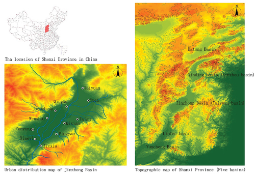
In addition, Jinzhong Basin is the origin and important node of “Ten thousand-li Tea Road [万里茶路]” (China Section). The sorting out of the changes of historical cities in Jinzhong Basin will serve the work of World Heritage application. On 20 March 2019, “Ten thousand-li Tea Road” (China Section) was officially listed in “China’s world cultural heritage preliminary list”, and Shanxi was also listed as one of the recommended sites to declare (National cultural heritage administration Citation2019). Jinzhong Basin, as the only way and important node of “Ten thousand-li Tea Road” (The city of Taiyuan, Yuci, Qixian, Taigu, Pingyao and Jiexiu), is of great significance to the study of its historical urban transformation.
However, in most current studies, the historical cities are analyzed considering water or multi factors (Alsayyad Citation2011). There is a lack of an overall framework, which is a novelty in the field of our research. These factors include natural factors and unnatural factors. Among them, the natural factor mainly refers to the water system, which is the necessary natural condition for human origin and survival (Wang, Dong, and Boelens Citation2018). And unnatural factors include political, economic, military, institutional and other factors. For example, the research of Federico Camerin is to explore the close relationship the connection between the city-making process and the military presence (Camerin Citation2020). Most of the studies on the historical changes of cities are divided by time, or take the case city as the research object, which is an in-depth analysis of individual city cases, which is similar to the record form of local records (Kostof Citation1995). For the study of Chinese urban history, administrative division is a unique unit form of Chinese historical cities (Schinz Citation1996). Therefore, most of the research is based on the administrative division as a unit of city or city groups. However, all the fundamental factors that affect the origin and change of cities are derived from the natural terrain. The basin is the most typical, which not only provides material conditions for the origin of cities, but also provides transportation and other necessary conditions for their development. Therefore, this study aims to achieve the following objectives:
Propose a framework to study transformation of historical cities from the perspective of Basin.
Apply regional level (urban density, urban structure, urban distribution), city group level (water system, military, traffic factors), and city form level (city shape, street form, functional zoning) to comprehensively analyze transformation of historical cities.
Propose a method of interpretation and translation of historical maps.
Provide significant insights for historical city transformation and urban culture sustainable development.
2. Methodology
2.1. Overview of methodology
shows the flow of this study. In the first step, according to the geographical factors of Jinzhong Basin, three factors affecting the origin and development of cities in the region are selected, which are water system, military position and transportation system. These three factors have a major impact on the city at three different levels, namely, the regional level, city group level and city form level. At the regional level, the water system mainly determines the urban density, the military status determines the urban structure, and the transportation system determines the distribution of the city in each period. At the level of city, three city groups are formed, which are respectively affected by water system, military system and transportation system. In the level of city form, it shows that the water system influences the city shape, the military system influences the street form of the city, and the traffic system mainly determines the functional zoning of the city. These three research levels and three main influencing factors interact. It forms a framework to study the transformation of historical cities with basin as the starting point.
Figure 2. Flow chart for the methodology applied in this study.
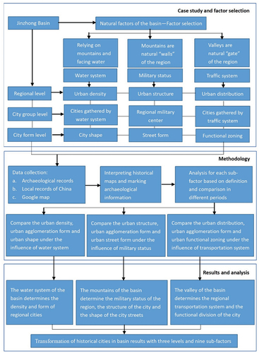
In the second step, data collection, mainly from archaeological data and local records of ancient China. And the historical map and historical information are marked on the Google map. This is the process of interpreting and marking historical information. Third, upon the completion of data collection, we compare the influence of three levels and three factors on the change of historical cities to summarize the characteristics of regional culture and provide suggestions for the sustainable development of urban culture.
2.2. Translation of historical maps
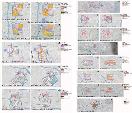
Historical map translation is to extract important historical information from local chronicles, historical materials and field research, position it on modern urban maps in the form of spatial elements, and “translate” the spatial information from historical maps to modern maps. Historical map translation is the visualization of HUL (Historic Urban Landscape) method. By integrating the historical maps of different periods, the existing cultural heritage of the city can be viewed in a layering way. HUL is a continuous dynamic evolution. In the process of evolution, the superposition of landscapes in different periods is the connotation and value of urban cultural landscape and history. shows the five steps of historical map translation, which is a long-term and open process. With the deepening of research, information can be corrected continuously. In the process of continuous dynamic evolution, the results of historical map translation are also replenished and accumulated at any time. is the historical map of historical cities in Jinzhong Basin. The number of maps available varies from city to city. These historical maps are from the local chronicles of China, and they are comprehensive historical works that record the local conditions in ancient China. The historical map records the basic form of the city, the relationship with the surrounding landscape environment, and the main streets and functional buildings in the city. But these maps don’t have scale, they’re just for illustration. Therefore, it is necessary to“translate”the historical map. shows the translation results of historical maps of historical cities in Jinzhong Basin. Each historical city can collect different amount of historical information, so the number of maps that can be translated is also different. These maps are divided into different levels by different colors, which show the outline of each city, the roads and the relationship with the surrounding landscape. Different colors indicate different functions of land in the city. If there is no color marked area in the city, there is no relevant information. This is the embodiment of HUL method in the historical map. For example, Yangqu (the city of Taiyuan), as the capital city of Shanxi Province in some historical periods, has more information, so there are four periods of historical map translation.
Figure 3. Flow chart for historical map translation.
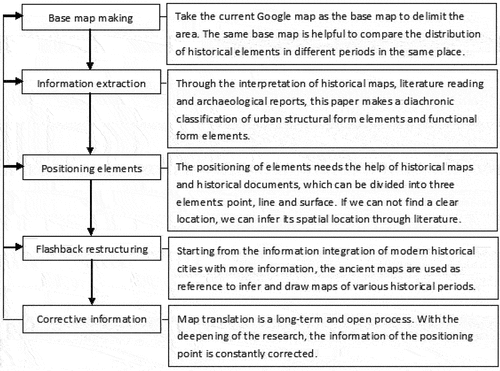
Figure 4. Historical map of historical cities in Jinzhong Basin.
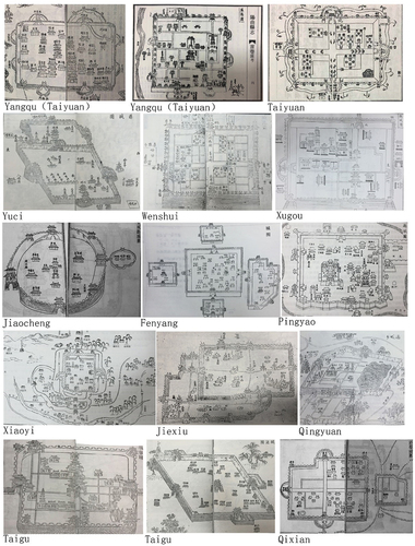
Figure 5. Historical map translation of historical cities in Jinzhong Basin.
3. Results
3.1. JinZhong Basin in space and time
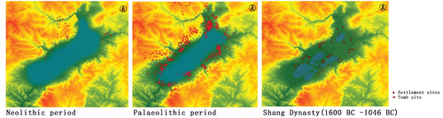
Human activities occurred in Jinzhong Basin about one million years ago. The sites of the Paleolithic and Neolithic Jinzhong Basin are distributed in a “ring like” pattern on the low mountains, hills or gullies around the Jinzhong Basin (). With the decrease of water area, the site gradually approached the center of the basin. According to the documents of the pre Qin period (Paleolithic period-221 B.C.), Jinzhong Basin was a water country with lakes and swamps (Song Citation2013). The great lake is called “Zhaoyuqi” (Wang Citation2000). Therefore, since the pre Qin period, the sites of Jinzhong Basin were distributed in the tributaries of “Zhaoyuqi”. From the perspective of spatial distribution, the sites are mainly located in the piedmont of gentle slopes and hills on the east and west sides of Jinzhong Basin (). Shanxi’s Shang (1600 B.C.-1046 B.C.) culture remains are also widely distributed, and 638 sites have been found in the territory (He Citation1996). As the big lake “Zhaoyuqi” dries up, these sites are closer to the center of the basin. They are distributed by the lake or on the flat land between the lakes. And the distribution of tombs is basically consistent with that of cities (). It can be seen that mountains and water determine the distribution of the sites in the basin, and also provide resources for human survival. Some of these sites disappeared, while others developed into cities.
Figure 6. Distribution of sites in Jinzhong Basin during Neolithic, Paleolithic and Shang Dynasties.
3.2. Regional level
The regional level is to analyze and summarize the characteristics of urban historical landscape in the whole Jinzhong Basin. The specific three layers are the changes of water system and regional urban density, military and regional urban structure, transportation system and regional urban distribution. This is also HUL’s performance in geographic areas. The change of water system leads to the occurrence of urban flood disasters, and also changes the urban density in the region. Military status leads to the occurrence of urban war, but also changes the urban population in the region, thus changing the urban structure in the region. The change of the transportation system affects the distribution of the city, and the city changes with the road.
3.2.1. Water system and urban density
The distribution of settlements and cities in the early Jinzhong Basin depended on mountains and rivers, and the change of water system was one of the important factors affecting the urban density. In the early stage of urban development, the relationship between cities and water system was mainly reflected in the restriction and guidance of urban site selection. Human activities depended on water sources, and for the sake of flood control, they should not be too close to water sources. In the process of urban development, the guidance of water system is also reflected in the layout of urban defense system. The construction of defense facilities, such as guard posts, passes, and fortresses, is along the water system. In addition, the water system becomes a part of the urban defense system in cities close to water sources. Therefore, water system plays a guiding role in the formation, development and accumulation of cities in Jinzhong Basin. It can be divided into three stages. In the first stage, the water presents a surface (Paleolithic period-221 B.C.). That is, the big lake “Zhaoyuqi” exists in the middle of the whole Jinzhong Basin, the ancient cities and sites are distributed along the lake. In the second stage, the lake gradually silted up and was replaced by several smaller lakes, and cities are distributed along the residual lake water. In the third stage, the water becomes linear (1368 A.D.-1644 A.D.). The main cities in Jinzhong Basin are distributed along rivers (Shanxi Institute of historical records Citation1999a). The river running through the north and south is called Fenhe River, and the others are tributaries of Fenhe River. The water system structure in this stage is also the water system structure in Jinzhong Basin today.
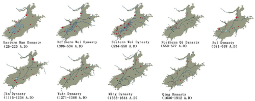
The density of cities in Jinzhong Basin changed with the change of water system (). During the Qin, Han and southern and Northern Dynasties (221 B.C.-589 A.D.), the urban density of Jinzhong Basin fluctuated greatly. During the Qin and Han Dynasties (221 B.C.-220 A.D.), the urban density was 2.4 × 10⁻³/km2. During this period, the main cities in Jinzhong Basin had appeared, and they were mainly distributed around the grate lake “Zhaoyuqi”, where products are rich and transportation is convenient. During the Northern Wei Dynasty (386 A.D.-534 A.D.), the urban density decreased to 2.0 × 10⁻³/km2, and the cities were distributed along the Fenhe River and its tributaries. In the Eastern Wei Dynasty (534 A.D.-550 A.D.), the urban density is the highest, which was 4.2 × 10⁻³/km2. And the urban density in the south part of Jinzhong Basin is obviously higher than that in the north. By the time of the Northern Qi Dynasty (550 A.D.-577 A.D.), there were only two small lakes left. With the narrowing of “Zhaoyuqi”, the urban density decreased to 2.0 × 10⁻³/km2. The city was still distributed along the Fenhe River and its tributaries. At this time, the urban density tended to be stable. After the Sui Dynasty (581 A.D.-619 A.D.), the urban density showed an upward trend. Compared with the Qin and Han Dynasties, the urban density of the Sui Dynasty (581 A.D.-619 A.D.) was the lowest, which was 1.8 × 10⁻³/km2. By the Jin Dynasty (1115 A.D.-1234 A.D.), the urban density reached 2.6 × 10⁻³/km2. The density of cities in Yuan Dynasty (1271 A.D.-1368 A.D.) and Ming Dynasty (1368 A.D.-1644 A.D.) was 2.6 × 10⁻³/km2, which is the same as that in Jin Dynasty (1115 A.D.-1234 A.D.). By the Qing Dynasty (1636 A.D.-1912 A.D.), although the urban density was reduced to 2.2 × 10⁻³/km2, the distribution among cities was more balanced (Shanxi Institute of historical records Citation1999a). The urban density of this period is also the urban density of Jinzhong Basin today (). The density of cities in Jinzhong Basin changes under the influence of water system.
Figure 7. Urban distribution and water system map of Jinzhong Basin in historical period.
3.2.2. Military and urban structure
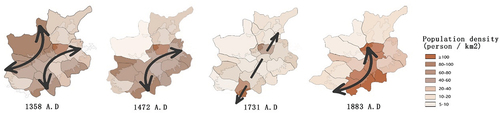
The influence of military on urban structure is mainly reflected in the influence of war on population. The area with frequent wars has a small population, on the contrary, the population is relatively stable. The places with frequent wars are also places with important military status and important cities. Therefore, it can be said that the military situation in the whole region determines the structure of the city. Due to the influence of the war, the population distribution in Jinzhong Basin increased and decreased four times during the Ming (1368 A.D.-1644 A.D.) and Qing (1636 A.D.-1912 A.D.) Dynasties (Bojun Citation1981). These four changes also determine the different population structure of the four stages (). The population structure of these four stages is also the urban structure.
Figure 8. Analysis of population density in different cities and urban structure.
3.2.3. Transportation system and urban distribution
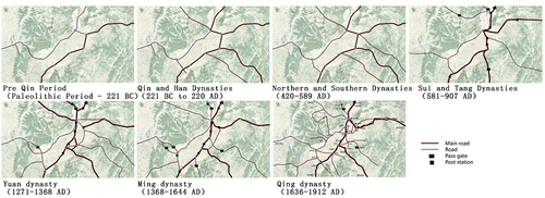
The traffic system in different periods of Jinzhong Basin is the main factor affecting the urban distribution. Cities are mainly located at road intersections. The early stage of road formation, it is determined by physical geography. The roads in the basin are divided into East and west along the mountains, running through the north and south of the basin (). From the pre Qin period (Paleolithic period-221 B.C.) to the Qin Han period (221 B.C.-220 A.D.), the basic network of traffic roads was formed, and cities were distributed along the main roads. And during the Northern and Southern Dynasties (420 A.D.-589 A.D.), the development of economy promotes the development of road. Jinzhong Basin is the eastern end of the grassland Silk Road, so the economy is prosperous. From Sui, Tang, Five Dynasties (581 A.D.-960 A.D.) to Yuan Dynasty (1271 A.D.-1368 A.D.), post stations gradually rose, which promoted the prosperity of the roads and cities. During the Ming and Qing Dynasties (1368 A.D.-1840 A.D.), Shanxi Merchants developed rapidly. Transportation system promotes the development of cities along the way. It also determines the distribution of cities in different periods.
Figure 9. Traffic system and urban distribution of Jinzhong Basin in different historical periods.
3.3. City group level
According to the three main factors of water system, military status and transportation system, cities are divided into three groups (), which are the intermediate link between “regional level” and “city level”. The three groups of city are Wenyu River city group (Jiaocheng, Wenshui, Fenyang and Xiaoyi), Taiyuan and its surrounding city group (Yangqu, Taiyuan, Xugou, Qingxu and Xuci) and post road city group (Taigu, Qixian, Pingyao and Jiexiu). Among them, Wenyu River city group is the most obvious area affected by water system changes. The characteristic of this group is close to the water system, and the cities are rebuilt frequently to deal with the flood. Taiyuan and its surrounding city group are the most important area in military status, which are characterized by frequent wars and frequent construction of cities damaged by wars. The post road city group is the most obvious area affected by the transportation system, which forms a prosperous commercial road. Therefore, three groups of cities in Jinzhong Basin can be obtained. These three urban agglomerations are also the embodiment of HUL, that is, under the influence of three levels, the cities in the region are grouped.
Figure 10. Three groups of cities in Jinzhong Basin.

The origin and change of cities in Jinzhong Basin are affected by water system, but Wenyu River city group (Jiaocheng, Wenshui, Fenyang and Xiaoyi) is the most obvious areas affected by water. These four cities are also the areas with the most flood records. The flood destroyed the cities, so they were also the cities with the most records of repair. In addition, the water god sacrificial architecture system reflects the interaction between the regional culture and the natural environment in the four cities along the Wenyu River. The temples along the Wenyu River can be divided into three categories according to the different belief bodies. First, the natural water body is the God of water, such as the River Temple, the Spring Temple and the Pool temple. This kind of temple is usually distributed near the water source, which is closely related to life and agriculture. Second, animals are water gods. Among them, the most common one is the Dragon God, such as the Dragon King Temple, the Five Dragon King Temple, the Black Dragon Temple, and the Dragon Heaven temple. This kind of temple is usually distributed near the dam. Third, the hero is the God of water, such as Tangwang temple, Dayu temple and Runze Hou Temple. Affected by the flood, there are more and more water god sacrificial buildings along the Wenyu River. The types and changes of these temples also reflect the interaction between cities and water in the region.
Through the records of historical city restoration and historical war events in local chronicles, we can get the most frequent war areas in Jinzhong Basin. That is, the area with the most important military position, including Taiyuan and the surrounding cities of Yuci, Qingyuan and Xugou. shows the time and frequency of building and repairing historical cities in Jinzhong Basin. The data comes from the records of the creation and construction of cities in local chronicles. From 802 B.C. to 1900 A.D., there are 167 records. The horizontal axis shows the time division of building and repairing the city. The vertical axis represents the number of projects. The black and white lines indicate the frequency of the project. If the slope is high, it means more project per unit time. And if the slope is gentle, it means less work per unit time. According to , the frequency of city construction alternates between fast and slow, which can be divided into five stages. They are 802 B.C.-580 A.D., 581 A.D.-1367 A.D., 1368 A.D.-1566 A.D., 1567 A.D.-1643 A.D. and 1644 A.D.-1900 A.D. The shows the events corresponding to the five time periods and the main cities where the events occurred. According to and , it can be concluded that Taiyuan and its surrounding cities are the areas most affected by the war. Therefore, Taiyuan, Yuci, Qingyuan and Xugou have the most frequent wars and the most important military position.
Figure 11. The time and frequency of building and repairing historical cities in Jinzhong Basin.
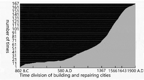
Table 1. Comparison between the construction stage of historical city and main historical events in Jinzhong Basin.
The earliest and most important post road is located in the eastern margin of Jinzhong Basin, connecting four cities of Taigu, Qixian, Pingyao and Jiexiu. This city group are the most obvious area affected by the transportation system. This road runs through the north and south of Jinzhong Basin. It is the business road of Shanxi merchants and the only way of “Ten thousand-li Tea Road” since Ming and Qing Dynasties (1368 A.D.-1840 A.D.). The density of post stations and delivery shops on this road is also the highest. The above is the reorganization of the overall structure of historical cities in Jinzhong Basin. According to the water, military status and road system, the cities in Jinzhong Basin are divided into three groups. These three groups also reflect the three characteristics of historical cities in Jinzhong Basin: close to water sysem, centrality and connectivity. These three characteristics have an impact on city shape, street form and functional zoning.
3.4. City form level
City level research is to analyze and summarize the characteristics of different historical landscape elements reflected in a single city. It is embodied in the city shape, street form and functional zoning. The shape of a city is related to the surrounding topography and water system. The form of street is mainly related to war defense. Urban functional zoning mainly reflects the characteristics related to the transportation system.
3.4.1. City shape
Judging from the location and shape of the cities, these cities in Jinzhong Basin not only conform to the etiquette of urban planning, but also conform to the natural terrain and environment. The shape of the cities in Jinzhong Basin is square or rectangular or approximately quadrilateral (). The shape and angle of a city depends on the distance from the river. Some of these cities, the distance between them and the river system is less than 1 km. These city contours are not only parallel to the river, but also combined with the characteristics of the river system. For example, Qingyuan city is pentagonal, which because there are two sides parallel to the water system at the same time. And the south wall of Pingyao City is not a straight line, but a winding line along the Zhongdu river. And other cities, they are more than 1 km away from the water system. These cities are square, and the orientation is north and south. For example, Yuci city is 1.7 km away from Xiaohe River and Taigu city is 1.5 km away from Wuma river. These two cities are square, which is convenient for water use and not affected by water system. In the process of urban development, it is continuously affected by the changes of water system and flood, and there are two types of cities under the influence of water. First, the drainage channel passes through the city, accelerating the drainage in the city. For example, Runmin canal of Xiaoyi city passes through the city, connecting Fenhe River and Xiaohe river. And in Jiexiu city, the canal runs through the city, connecting the north water gate with the south water gate. Second, the water accumulated in the low-lying areas of the city and formed lakes. For example, East Lake is gradually formed in the southeast corner of Qingyuan city, and Yuebo lake is formed in the southeast corner of Jiaocheng city. Lake has an impact on layout and functional zoning in the city.
Table 2. Morphological characteristics of historical cities in Jinzhong Basin in Ming and Qing Dynasties.
As can be seen from , another important part of the urban outline is the Gate city. In the process of urban development, city continuously affected by the war. In order to meet the needs of garrison, the city began to build more Gate city. Therefore, there are three types of city shape. The first is “one city, one gate city”. The second is “one city, many gate cities”. The third is “one city, many gate cities”, and the gate cities are connected with each other (). The size and quantity of gate city are related to the actual demand, and also related to the size of the main city. The size and quantity of gate city are related to the actual demand, and also related to the size of the main city. For example, four gate cities in four directions are built in Fenyang city, which is to meet the needs of the city after upgrading. And these four gate cities are independent and not interrelated. However, in other cities, gate cities are linked together, such as Xiaoyi city and Jiexiu city. Xiaoyi city is connected by gate city in the west and in the south, Jiexiu city is connected by gate city in the north and the east. To sum up, the shape and location of a city are influenced by terrain, city level and defense needs. In the Qing Dynasty (1636 A.D.-1840 A.D.), due to the stability of the political situation, most gate city disappeared.
3.4.2. Street form
The shape of streets is also affected by topography, politics and other factors. But military defenses affected the shape of the main streets. According to the characteristics of the main street structure, the cities in Jinzhong Basin can be divided into three types () (). First, “Cross-shaped” structure, it means that the two streets connecting the east-west and north-south gates intersect vertically. For defensive purposes, there is usually a building at the intersection of two main streets. For example, Wenshui city has a DaGuan building at the intersection of cross shaped streets, and Jiexiu city also has a cross shaped building in the center of the city. Second, “Approximate cross-shaped” structure, it means that there are still four main streets connecting the four directional gates, but only East Street and West Street are connected, or only South Street and North Street are connected. For example, Taigu city only has east street and west street connected, while Xiaoyi city only has south street and north street connected. The third is the “T-shaped” structure, that is, the streets connecting the four gates are not directly connected, but they form T-shaped with each other. For example, both south gate street and north gate street in Qingyuan city are perpendicular to east gate street, but north gate street and north gate street are not connected. This kind of street structure is also for the need of defense.
Table 3. Street structure classification of historical cities in Jinzhong Basin.
3.4.3. Functional zoning
According to the marking of the location of the main function buildings in the city, the main function of the city can be divided into five categories: government office, sacrifice, education, residence and commerce. (). Government office buildings are usually located in the middle of the city, and most of them are centrally arranged, which is convenient for communication and management, and also determines the spatial layout of the whole city. For example, the government office buildings in Yuci city, Taigu city and Fenyang city are all located near the intersection of central cross-shaped street. Sacrificial buildings are divided into sacrificial buildings outside the city and within the city. The sacrificial architecture outside the city is combined with the ritual function and the natural landscape. And the sacrificial architecture in the city is mainly composed of Town God’s Temple, Wu Temple and Confucious’ Temple. As it serves the government, the layout is close to the office building. Educational buildings include schools, Confucianists, county schools, government schools and academies. They are usually local government schools, so they are also located in the main location of the city or near the office buildings. Residential buildings have no obvious layout characteristics. The commercial buildings are usually connected with the post road system and the delivery system. The place where the post road passes through is the commercial prosperous area in the city.
4. Discussion
The change of the city is the result of the comprehensive effect of various factors in a certain period, including natural, economic, political, social factors and so on. For Jinzhong Basin, there are three main influencing factors in the process of urban origin and sustainable development. These three main factors are usually also the characteristics of the origin and change of all basin cities. First, the topography and natural resources of “two mountains and one river” in the basin are the basis of the origin of the city. Among them, the change of water system is the most frequent. Second, the basin is surrounded by mountains, which makes it a natural “city wall”, which is easy to defend and difficult to attack. Therefore, the basin region has an important military position. Third, because of the enclosure of the mountains, a natural “city gate” was formed at the gap of the mountain. By the end of the Qing Dynasty (1636 A.D.-1840 A.D.), due to the convenience of transportation, it promoted the prosperity of Shanxi merchants. Therefore, the water system, military status and transportation are the main factors that affect the urban changes in the basin. These three main factors can be used to construct the research framework of basin historical city transformation in the three levels of region, city group and city.
4.1. Basin topography: two mountains and one river
The topography of Jinzhong Basin can be summarized as a valley basin with “two mountains and one river”. The “two mountains” refer to Taihang Mountain in the east and Luliang Mountain in the west of the basin. The “one river” refers to Fenhe River running through the basin. The “one river” also refers to the big lake Zhaoyuqi before Qin and Han Dynasties (221 B.C.-220 A.D.). The influence of basin topography on historical city transformation is mainly reflected in three aspects:
First, the influence on city location at the beginning of its formation. The center of the basin was the great lake before Qin and Han Dynasties (221 B.C.-220 A.D.). At that time, the early human settlements lived along the lake. When the lake gradually silts up and turns into a river, cities are distributed along the river. The river not only provided domestic water for the city, but also served as a transport carrier for the city. Second, in the process of water system changes, the shape and structure of the city are gradually affected. For example, Jiaocheng city, at the intersection of Wenyu River and Ciyao River (tributaries of Fenhe River), presents a rounded shape to avoid flooding (). And Xiaoyi city is located at the intersection of Wenyu River and Xiaohe river (tributaries of Fenhe River). In order to conform to the water system and terrain, it presents the form of connecting south gate and west gate (). Xugou city is located between Jinshui river and Gayu river (tributaries of Fenhe river). The city is parallel to the river and shows an angle of 10 ° to the East. Both sides of Qingyuan City are parallel to Baishishui river, showing a pentagonal form of the city. Third, it has an impact on the location of the peripheral functional space factors of the city. The external space factors usually include sacrificial temples, ancestral halls, defensive passes, fortresses, transportation stations and delivery shops. Sacrificial temples and ancestral halls are usually located near the water system around the city or on the mountain, which is an important belief space in the city. For example, Jinyang (Taiyuan city), built Jin memorial temple at the foot of the mountain to the west of the city, and Tianlongshan Grottoes temple on the mountain. As the carrier of belief space, these building, together with mountains and water, constitute the unique spatial axis of traditional Chinese cities and are incorporated into the layout of the whole city. In addition, the site selection of defensive passes and fortresses is also affected by the terrain and topography of the basin. The passes are usually located in the mountains of the entrance and exit of the basin, and the fortresses are located in the location of convenient transportation, close to the water source and close to the mountains. And the location of transportation stations and delivery shops is also affected by the mountains and water systems in the basin. The post station is set along the post road, and the post road is arranged according to the mountain and water system. To sum up, the topography of the basin affects the formation and development of cities from three aspects, and runs through the whole stage of urban change.
4.2. Military – the main factor of urban development in Jinzhong Basin
Shanxi Province is surrounded by the Yellow River in the west and south, Taihang Mountain in the east, the Great Wall in the north, and basins in the middle. From the perspective of the whole territory, the mountain can be regarded as a natural “city wall”, and the water can be used as a natural “moat”. Therefore, Shanxi Province is the place for the ruling class to fight. Jinzhong Basin is also easy to defend and difficult to attack, which has an important military position in different historical periods. During the period of Central Plains warlords’ struggle (221 B.C.-220 A.D.), because of its location in the middle and convenient transportation, the whole Jinzhong Basin became a “four battle zone”. During the period of the split of the central dynasty (220 A.D.-684 A.D.), Datong, in the north of Jinzhong Basin, was the front line of the war. At that time, the agriculture of Jinzhong Basin was developed, which provided food and other materials for Datong, and also promoted the development of trade and commerce. In the period of the central dynasty’s reunification (1368 A.D.), Jinzhong Basin was regarded as the hub of consolidating the regime. In this period, a large number of fortresses were built for defense, and a delivery system was built for information transmission. These functional factors gradually developed into towns and villages in the Ming and Qing Dynasties. It can be seen that military is the main factor in the development of cities in Jinzhong Basin. The changes of cities in the basin are mainly reflected in the following four aspects.
First, the competition among the ruling classes affects the administrative division and management of the region, and also determines the layout and functional axis of the city. The administrative division is a unique system of ancient Chinese cities. The administrative division in different periods reflects the struggle between the regimes and the policies at that time. During the Warring States period (475 B.C.-221 B.C.), Han, Zhao and Wei were divided into Jin State, and Jinzhong Basin belonged to Zhao state. When the Qin Dynasty (221 B.C.-207 B.C.) unified the whole world, Jinzhong Basin belonged to Taiyuan county. The local administrative system of the Western Han Dynasty (202 B.C.-8 A.D.) followed the county system of the Qin Dynasty (221 B.C.-207 B.C.). In the Northern Wei Dynasty (386 A.D.-534 A.D.), there were 10 cities in Jinzhong Basin, which increased to 21 in the Eastern Wei Dynasty (534 A.D.-550 A.D.) and decreased to 8 in the Northern Zhou Dynasty (557 A.D.-581 A.D.). By the Sui Dynasty (581 A.D.-618 A.D.), the political situation was stable. In the Ming Dynasty (1368 A.D.-1644 A.D.), under the system of Wei Suo, the way of administration changed again, which led to the increase of central cities. In Jinzhong Basin, there were two government governances, namely, Taiyuan government governs Yangqu and Fenzhou government governs Fenyang. In the Qing Dynasty (1636 A.D.-1972 A.D.), a new way of military management appeared. It is “Eight Banners garrison system”, which means to build “Manchu city” in the important cities of the country. “Manchu city” was a city for Manchu people to live in, and the Manchu people in the city were responsible for expanding the ruling scope of the Qing government and monitoring the local Han people. Among them, the Manchuria city in Taiyuan city is the earliest one among the 20 Manchuria cities in China, which is located in the southwest corner of Taiyuan City in Ming (1368 A.D.-1644 A.D.) and Qing (1636 A.D.-1972 A.D.) Dynasties. The construction of Manchuria city also determines the pattern and function axis of Taiyuan city. Second, the concentration of war affected the regional population structure. And the regional population structure has an impact on the urban structure. For example, due to the influence of the war, the population of Jinzhong Basin experienced four sharp reductions in the Ming (1368 A.D.-1644 A.D.) and Qing (1636 A.D.-1972 A.D.) Dynasties. From the population density of 1368 A.D., 1472 A.D., 1731 A.D. and 1883 A.D., we can conclude that the high population density area has less wars and more stable social environment. In 1368 A.D., the Northern Expedition army of the Ming Dynasty (1368 A.D.-1644 A.D.) destroyed the Yuan Dynasty (1271 A.D.-1368 A.D.). At that time, the border minorities invaded the Jinzhong Basin. The main battlefields were the city of Yangqu, Xiaoyi and Yuci. Therefore, these three areas were also the areas with the lowest population density at that time. Therefore, the war will reduce the population density, and the population structure also has an impact on urban structure. In the population concentration area, the market and other functional factors are relatively concentrated, thus presenting a rich urban spatial structure around the city. Third, the defense system of the city is the foundation of the formation of villages and towns around the city. The defense system here refers to the fortress, post station and delivery shop outside the city, which played the role of defense and information transmission in wartime. Since the Qing Dynasty (1636 A.D.-1972 A.D.), with the gradual stability of the political situation, the original fortress and delivery shop developed into villages and towns and became long-term population gathering places. Therefore, the defense system gradually evolved into a part of urban system. Fourth, the policy of serving the war has promoted the development of regional economy. In 1370 A.D., the border areas of Shanxi were in urgent need of military supplies. In order to provide materials for a large number of garrisons, the rulers recruited private merchants to transport supplies and horses. And merchants who complete the transportation can obtain permission from the salt industry. This policy attracted many businessmen along the way. To sum up, the factors of military politics play an important role in urban administrative division, urban regional structure, urban system and economic development, so military politics is the main factor of urban development in Jinzhong Basin.
4.3. Transportation – the lasting power of urban development in Jinzhong Basin
The development of regional transportation in Jinzhong Basin in different historical periods has an impact on the military, political or economic development. According to the order of time, it is mainly reflected in the following four aspects:First, the traffic pattern from the pre Qin (Paleolithic period-221 B.C.) to the Qin (221 B.C.-207 B.C.) and Han Dynasties (202 B.C.-220 A.D.) made the region become the focus of political power struggle. In order to consolidate the political power, roads were added to promote the further development of transportation. They promote each other. Second, during the northern and Southern Dynasties (220 A.D.-589 A.D.), Jinzhong Basin connects Luoyang, the new capital, and Pingcheng, the old capital in the north and south, and Beijing and Xi’an in the East and West. The transportation is very convenient. So it became a market at the southern end of the silk road. The trade of commodities promoted the prosperity of the city and further increased the construction of roads. Third, the rise of post station and delivery shop system from Sui and Tang Dynasties (581 A.D.-907 A.D.) to Yuan Dynasty (1271 A.D.-1368 A.D.), which is the foundation of the formation of towns around the city and promotes the improvement of urban structure. Fourth, in the Ming (1368 A.D.-1644 A.D.) and Qing (1636 A.D.-1912 A.D.) Dynasties, under the influence policies and transportation, Shanxi Merchants flourished. To sum up, regional transportation continues to promote the changes of cities in Jinzhong Basin, which is the lasting power of urban development.
5. Conclusions
Previous studies focused on a certain element in the process of urban change, such as water system or military, but each element is based on the geographical characteristics of the region. Aiming at the lack of basin natural environment in historical city research, this study provides a framework to study transformation of historical cities from the perspective of Basin. At the same time, this study also provides a method of interpretation and translation of historical maps. Through the study of the changes of historical cities in Jinzhong Basin, we can see that water system, military status and transportation system are the three major factors affecting the historical urban transformation in the basin. These three factors affect the changes of cities in three aspects: region, city group and city form. The main impact on the region is urban density, urban structure and urban distribution, and the impact on the city group is the formation of urban external space. The impact on the city level is the shape of the city, street form and functional zoning. This study provides a culture oriented direction for the future development of historical cities in Jinzhong Basin, serving the “Ten thousand-li Tea Road” application for world heritage in the region, and the research framework provides a theoretical basis for the study of historical cities in basin area. This is also an important part of the sustainable development of urban culture. The research is a dynamic and open process, that is, with the deepening of archaeological work, more historical materials and data will be used for more accurate historical map translation, providing more details for the development of historical cities today. Therefore, the future research will focus on the archaeological information of each historical city, and improve and continue to study the translation of historical maps. However, there are also some limitations in the research, which only focus on the historical cities in the basin region, while for the cities in the plain or plateau, the research framework needs to be adjusted.
Disclosure statement
No potential conflict of interest was reported by the authors.
Additional information
Funding
Notes on contributors
Yan Zhang
Yan Zhang is a lecturer, College of Arts, Beijing Union University, Beijing, China. She focuses on traditional urban spatial form and architectural heritage protection.
Wei Dong
Wei Dong is a professor of Southeast University, Nanjing, China. He is engaged in the research of architectural heritage protection and ancient city protection.
References
- Alsayyad, N. 2011. Cairo: Histories of a City. Cambridge: Belknap press of Harvard University Press.
- Bojun, Y. 1981. Notes on Chun Qiu Zuo Zhuan. Beijing: Zhong Hua Book Company.
- Borghi, G. L. N. 2020. “Entre a clareza e a razão: considerações sobre Dante Alighieri na obra Della Perfetta Poesia Italiana, de Ludovico Muratori (Between Clarity and Reason: Considerations on Dante Alighieri in Della Perfetta Poesia Italiana by Ludovico Muratori).” Alea: Estudos Neolatinos 22: 2. doi:10.1590/1517-106x/2020222105118.
- Camerin, F. 2020. “The Role of the Great Property in the European City-making Process in the Last Third of the 20th Century.” Doctor Thesis. Accessed May 12, 2021. https://e-pub.uni-weimar.de/opus4/frontdoor/index/index/docId/4201
- Cody, J., and F. Siravo. 2019. Historic Cities: Issues in Urban Conservation.Los Angeles: Getty Conservation Institute.
- Du, X. 2013. History and Culture of Shanxi Province.Taiyuan: Shanxi Education Press.
- Farhan, S., V. Akef, and Z. Nasar. 2020. “The Transformation of the Inherited Historical Urban and Architectural Characteristics of Al-Najaf’s Old City and Possible Preservation Insights.” Frontiers of Architectural Research 9 (4): 820–836. doi:10.1016/j.foar.2020.07.005.
- Farhan, Akef, and Nasar. 2020. “Analysing the Transformed Urban Patterns of Al-Najaf Historical Center: Urgent Issues and Possible Solutions.” IOP Conference Series: Materials Science and Engineering 1058 (1): 012052. IOP Publishing. doi:10.1088/1757-899X/1058/1/012052.
- He, Y. 1996. History of Urban Planning in Ancient China. Beijing: China Architecture & Building Press.
- He, Y. 2014. “Chinese Urban History Studies Face the Twenty-First Century.” Chinese Studies in History 47 (3): 73–99. doi:10.2753/CSH0009-4633470304.
- Kostof, S. 1995. A History of Architecture: Settings and Rituals.New York: Oxford University Press.
- National cultural heritage administration. 2019. “Preliminary List of China’s World Cultural Heritage.” Accessed 01 March 2019. http://www.ncha.gov.cn/
- Saboya, R. T. 2020. “O estudo da forma urbana em Santa Catarina, Brasil (The Study of Urban Form in Santa Catarina, Brazi).” Urbe. Revista Brasileira de Gestão Urbana 12: e20190269. doi:10.1590/2175-3369.012.e20190269.
- Saxenian, A. L. 1996. Regional Advantage. Cambridge: Harvard University Press.
- Schinz, A. 1996. The Magic Square: Cities in Ancient China. Stuttgart: Edition Axel Menges.
- Shanxi Academy of historical records. 1997. History of Shanxi Province. Beijing: ZHONGHUA Book Company.
- Shanxi Institute of historical records. 1999a. General Records of Shanxi (Volume II Geography). Beijing: ZHONGHUA Book Company.
- Shanxi Institute of historical records. 1999b. General Records of Shanxi (Volume 10 Water Conservancy Records). Beijing: ZHONGHUA Book Company.
- Shiqiao, L. 2014. Understanding the Chinese City. California: Sage.
- Smith, L. 2006. Uses of Heritage. London: Routledge.
- Song, Y. 2013. Paleolithic Archaeology in Shanxi Province. Taiyuan: Shanxi People’s Publishing House.
- Wang, Y., W. Dong, and L. Boelens. 2018. “The Interaction of City and Water in the Yangtze River Delta, a Natural/artificial Comparison with Euro Delta.” Sustainability 10: 109. doi:10.3390/su10010109.
- Wang, Y. 2000. Paleolithic Archaeology. Beijing: Cultural Relics Publishing House.
- Zhang, Y., and W. Dong. 2019. “Determining Minimum Intervention in the Preservation of Heritage Buildings.” International Journal of Architectural Heritage. doi:10.1080/15583058.2019.1645237.