
ABSTRACT
With the normalization of the COVID-19 pandemic prevention and control, there is an urgent need to develop a healthy urban public space. However, because of the fast urbanization process with a series of problems, such as PM2.5 air pollution, the Urban Heat Island, and the relatively high frequency of static winds under the influence of its topography, the ventilation problem in the public spaces of Chengdu is of great importance. Along these lines, in this work, the history of theoretical research on urban ventilation is summarized and reviewed first to evaluate the urban wind environment. Second, so far, qualitative methods are mainly adopted for the evaluation methods of microclimate adaptation. However, the practical application has achieved few results. Meanwhile, there is still a lack of comprehensive and unified research on the multi-element of human microclimate comfort in public space. For this reason, the urban ventilation assessment system was established in this work according to the physical, physiological, and psychological aspects, with 9 indices selected and ranked. Then, an optimization strategy for rebuilding the urban public space was proposed for improving the wind environment microclimate adaption on three levels: macro city-regional level, meso block linear space, and micro space node. By taking Eastern Banlieue Memory Industrial Park as an example, the statistical data were systematically investigated on the spot from the results of 249 wind environment questionnaires, and 30 Delphi expert consultation questionnaires. Combined with the Computational Fluid Dynamics (CFD) simulation, the results reveal that most public spaces in the study area were below 0.6 m/s in more than 80% of the public space, and wind-based environmental problems obviously exist without any ventilation improvement measures. Combined with the background of the carbon peak era, the ventilation environment of the urban public space is not conducive to using active ventilation equipment. The solution of a complete set of regional intelligent ventilation systems was thoroughly discussed here, while some innovative sustainable systematic solutions and urban ventilation furniture combined with a geothermal heat pump and cloud data platform were formulated.
1. Introduction
1.1. Background
In ancient China, people normally paid attention to the principal geomancy when building and city layout. The main goal was to regulate the local climate regulation and prevent disasters by coordinating the relationship between the cities and climate resources. However, with the wide construction and development of the cities, the resulting air pollution problem is becoming increasingly severe (Xiaoqi et al. Citation2020; Chao et al. Citation2022).
In February 2016, the Chinese national development, and Reform Commission in conjunction with the Ministry of housing and urban-rural development prepared an action plan for urban adaptation to climate change, which proposed: “Relying on the existing urban green space, roads, rivers, and other public spaces, open up Urban Ventilation corridors, increase urban air mobility, and alleviate urban heat island, haze, and other problems” (Xiaoqi et al. Citation2020; Chao et al. Citation2022).
According to the research of the Chinese National Climate Center, Chengdu is a city with high-frequency calm wind due to the terrain of the basin. The meteorological stations of Chengdu have monitored data from 2007 to 2016, demonstrating that the annual average wind speed in the urban area for many years is only 0.75 m/s. Compared to the urban calm wind judgment standard of 0.5 m/s, the calm wind frequency in Chengdu is as high as 40%. On top of that, the average wind speed of Chengdu is only half that of other cities, while the calm wind frequency is about twice that of the other cities ().
Figure 1. Comparison of urban wind environment in China (a: Comparison of average wind speed in major cities in China; b: Comparison of calm wind frequency in major cities in China; c: Comparison of PM2.5 levels in some domestic cities in 2021).
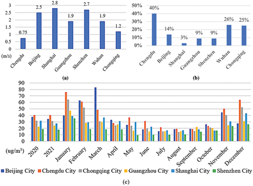
Chengdu maintains calm and light winds all year round, whereas the ventilation conditions cannot assist the diffusion of pollutants in the atmosphere. As a result, the formation of polluted weather is induced. In the World Air Quality Report 2021, it was found that the PM2.5 annual mean (μg/m3) in 2020, and 2021 is ranked first among the six first-tier cities in China. Interestingly, Chengdu’s coldest and hottest months of the year are also the months with the highest PM2.5 values (YANG et al. Citation2020) ().
1.2. Research origins
In the past urban planning, urban wind, and related environmental issues were often ignored and marginalized in China. However, with the rapid improvement of the urban public health system and the increased attention to the public space in the living environment, various works in the literature have been conducted on urban ventilation, urban microclimate, and so on. The search results of the keyword “Urban Ventilation” from the Web of Science (WOS) platform within the period of 20,010,101 to 20,221,230 showed that the top five ranked keywords were modelling air quality, using modern ventilation, semi-empirical model, urban morphology, idealized building. The timeline shows most related research is in the period of 2001–2010. The role of urban ventilation in a healthy living environment has not been paid enough attention to in the past four years since the outbreak of the epidemic ().
Figure 2. Timeline analysis burstiness pictorial based on related papers of Web of Science from 20,010,101 to 20,221,230.

Since 2003, Hong Kong has carried out evaluation research on urban air circulation, and based on the research results, issued guidelines for improving the ventilation design of building blocks. Since the 1970s, Davenport, Isyumov, Hunt, Lawson, Penwarden, Melbourne and other scholars have studied the wind safety threshold of pedestrian height in specific wind farms, but only for the mechanical comfort of pedestrians; Shi Xing and others put forward wind speed evaluation criteria for different types of places and pedestrian conditions based on mechanical comfort, safety, wind speed amplification effect and pedestrian’s subjective psychological tolerance to wind environment; The Chinese Standard for Evaluation of Green Buildings (GB/T50378–2019) proposes outdoor wind environment evaluation standards such as wind speed, wind speed ratio, wind pressure and a number of turbulence based on the architectural perspective. Based on the current evaluation criteria of wind environment, around the coupling relationship between urban form and wind environment, urban form parameters are used to characterize the characteristics of airflow, such as the street height-width ratio and the length-to-height ratio at the street level, and the zero-displacement plane, roughness length, roughness height, building coverage, windward surface index and sky openness at the city level.
In addition, scholars have conducted research on the correlation between wind environments and urban spatial forms, such as the identification of ventilation corridors at the overall level of the city, the evaluation of street valley wind environment at the street level, and the evaluation of outdoor wind environment at the building level. Since the 1990s, numerical simulation technology has broadened the research scope of urban wind environments and formed a research method combining “numerical simulation and field observation” quantitative analysis, and qualitative analysis. The numerical simulation technology includes a mesoscale weather forecast model (WRF) and micro-scale computational fluid dynamics (CFD).
The existing urban wind environment is mostly evaluated from a single boundary condition, ignoring the urban regionality. The improvement of the urban wind environment is also achieved by changing the urban spatial form and other methods, while the reality is relatively passive due to most of the conditions.
How to change the microclimate of urban local space by establishing a systematic, interactive, digital, and intelligent ventilation device. The feasibility of intelligent ventilation in urban public space is studied by selecting a typical public space of urban ventilation in Chengdu.
Furthermore, more multi-dimensional attempts should be carried out by urban planners to transform the intelligent ventilation and adaptive microclimate environment in the direction of green energy saving in urban public spaces, including cities, blocks, and public space nodes. For example, on the block scale, planners can directly control the building height, street width, building orientation, green space, leisure land distribution, etc. In addition, on the building scale, the wind environment is analyzed and simulated to examine the change law of the wind pressure and airflow. Innovative ventilation art installations or urban furniture are also used to change the microclimate ventilation environment of the residents.
As an important third-tier industrial city in the past, Chengdu has left many factory ruins. Meanwhile, Chengdu is currently in full swing to build a park city, with tourism, leisure, and shopping as the positioning to attract more young people. The Eastern Banlieue Memory Industrial Park is typical of these characters in Chengdu. Under this perspective, in this work, Eastern Banlieue’s Memory Industrial Park was used as the application case to propose a comfortable and healthy micro-climate environment with enhanced ventilation properties. However, the study of a complete set of regional intelligent ventilation systems in this work is universal and is not limited to this case.
1.3. Purpose of the research
The type of urban public space was taken as the carrier in this work. More specifically, the adaptive feeling mechanism of the wind environment in public space was determined by performing a thorough investigation and collecting the relevant data. What’s more, an adaptive physical, physiological, and psychological comprehensive evaluation index system was established. Moreover, the Internet of things and other technologies were actively used to establish a complete set of digital and intelligent ventilation equipment, which can adapt to the ventilation transformation of the urban public space. The goal of this work is that under the intelligent management and control mode, the passive adaptive transformation of the wind environment is studied from three levels——macro urban scale (plane), meso street scale (line), and micro node (point) by using physical effects such as wind pressure. Based on the concept of a healthy city, a low-carbon, and energy-efficient city, the public environmental occupational health can be improved, and the metropolitan general area can be transformed into a microclimate ecological area.(Datian Citation2022)
This work is systematic exploratory research that was carried out from the design level combined with technical measures in order to enlighten the relevant research designers, especially in the context of peak carbon and the three-year epidemic, where the existence of a public health environment is of crucial importance.
First, to improve the microclimate environment of urban public space, an optimization of the wind environment in a metropolitan public area was carried out. The main goal is to guide the air exchange inside and outside the city through the ventilation corridor, promote the gas flow, divide the urban heat field, remove the various urban air pollutants, and alleviate the urban heat island effect. However, establishing the Urban Ventilation corridor is a long-term process that requires implementing large-scale methods to transform the urban ventilation environment effectively. This method can be easily changed, and flexibility is not high enough. People’s intuitive feeling is also not apparent. Therefore, the development of a systematic, interactive, digital, and intelligent smart ventilation device with the capability of adapting to the microclimate of urban public space is the primary purpose of this work.
Second, human comfort should be enhanced in the microclimate environment in urban public spaces. The physical, physiological, and psychological effects of the local wind environment in urban public areas are considered three critical elements of the human comfort evaluation. By combining the evaluation results of the above-mentioned three elements, simulating the regional ventilation environment by using the green ventilation software PHOENICS 2019 package, and leveraging the “dialogue” between people and intelligent ventilation devices, the comfort of the human microclimate environment was improved.
*Calm wind: A meteorological condition in which the average wind speed is less than 0.5 m/s at a height of 10 m above the ground.
(Source: a, b adapted from China Meteorological Science Data Sharing Service Network, c adapted from 2021 world air quality report)
2. Theory
2.1. Research history
As early as 1937, in the book Urban climatology, it was proposed by German researchers that urban planning and construction would inevitably affect or even change the quality of the local air conditions and finally the whole climate properties. Immediately after World War II, in 1948, meteorologist Karl Schwalbe was appointed to use urban ventilation corridors to control air pollution in the overall urban development project ().
Table 1. Planning nodes and characteristics of air environment in foreign representative cities.
A theoretical framework that takes into account the total available space, the compensation space, and the air guide channel form a complete urban ventilation system (i.e., local circulation theory), which was proposed by a German scientist named Kress, was considered critical and has laid a theoretical foundation for conducting further research of ventilation corridors. We must underline that Japan has paid attention to the wind environment since 1990. It is also one of the countries that carried out ventilation duct investigations earlier and at the same time incorporated relevant norms into the indicators. The famous “Research report on the way of wind” was jointly completed by eight different cities and counties in Japan in 2007 (Yunhao Citation2021).
At the end of the 1980s, China’s planning field began a series of studies on the development of Urban Ventilation ducts. At that time, the idea of “introducing fresh air into the city” was first reported in articles on urban climate research. However, no urban planning applications were conducted at that time (Yan Citation2021).
The situation changed in 2003, when the planning department of the Hong Kong Special Administrative Region government, under increasing environmental pressure, began to pay more attention to this issue and entrusted Professor Wu Enrong of the Chinese University of Hong Kong to cooperate with the international team 18 L. Moreover, the feasibility of the air circulation assessment methods from the meso and micro levels of urban design was examined, leading to the domestic research trend on wind tunnel planning.
Other cities were also gradually awakened. For example, Wuhan incorporated the construction of an urban air duct into the urban master plan in 2005. At the beginning of 2015, a report was formulated by the research group “Investigation and Research on the construction of urban air duct scenic spots in Xi’an,” and the urban air duct system and air duct scenic spot system was constructed in Xi’an (Shanhe Citation2020).
2.2. Statistics of theoretical research status
Hong Kong, Wuhan, Beijing, Changsha, Langfang, Xi’an, Hangzhou, Fuzhou, Shenyang, Zhengzhou, Nanjing, Guiyang, and Jinan, as well as other cities, have carried out urban air duct planning ().
Table 2. Cities’ relevant standards and guidelines for official action in China.
lists the most significant cities in China that have prepared wind environment planning or already working on it. By considering the statistics in the literature from 1985 to 2016, more and more derivative-related research works appeared, in combination with a high correlation of research trends, such as “numerical simulation,” “natural ventilation,” “wind tunnel test,” and “high-rise buildings,” which led to the formation of a vast research network. Thus, it can be inferred that the study on urban ventilation corridors mainly focuses on air pollution and the heat island environment.
It has been reported that the wind speed near the ground in cities also has an essential impact on the thermal comfort of the residents. More specifically, a higher wind speed could lead to better thermal comfort, while the areas with low wind speed or urban calm wind areas are closely associated with higher temperature values (Yiwen Citation2019). In particular, the continuous development of the big data field has undoubtedly enriched the available methods for the development of ventilation corridors to alleviate the heat island effect (Qiantang Citation2019).
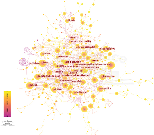
Additionally, it has been reported that the size of the wind speed is significantly correlated with the concentration of pollutants (Min Citation2002). In general, the investigation of the relationship between the Urban Ventilation corridors and air pollution has gradually shifted from the space-time pattern to the underlying formation mechanism based on aerodynamics, as well as the planning and prediction research based on simulations and regulations (Feng Citation2022) (). Currently, the available method for microclimate wind environment is quite limited, and the subjective evaluation method is adopted. Particularly, a questionnaire survey is normally used to directly ask people about the comfort degree of the wind environment in a certain urban space.
Figure 3. Keywords cluster pictorial analysis based on related papers of web of science from 20,010,101 to 20,221,230.
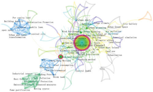
Figure 4. Keywords displayed together visual analysis based on related papers of web of science from 20,010,101 to 20,221,230.
On the one hand, the limitations of this type of subjective evaluation method cannot be ignored. Since the subjects are directly asked, the accuracy of the evaluation results can be easily affected by whether the subjects themselves can accurately judge the wind environment. On the other hand, the wind environment evaluation is complicated in many aspects. Explicitly, people in different regions have various feelings about a particular spatial wind environment. Even more, different individuals in the same region also have different cognition and feelings about the wind environment. The seasons, times, weather, and wind environment are also different in the same urban public space. The evaluation of the wind environment must be divided into seasons and exclude extreme weather. Moreover, it should be based on universal physical environment evaluation and normal physiological parameters of the human body, as well as a certain number of subjects’ overall psychological feelings about the wind environment. Therefore, it is necessary to systematically evaluate the microclimate wind environment by integrating the physical environment of the urban public space in combination with the physiological and psychological state of the users.
The comprehensive index system established in this work refers to specific indicators, including air temperature (Yan Citation2007), relative humidity (Tim et al. Citation1997), wind speed (Meilan Citation2012), skin temperature (Liang Citation2006), heart rate (Liang Citation2006), skin conductance level (Ruiyao Citation2020), and thermal sensation (ASHRAE. ANSI ASHRAE Standard 55–1992).
In addition, in the previously reported works in the literature, only the elements of ventilation have been examined, failing to link the idea of human adaption. According to the different types of objects, such as city streets, street space, public leisure space, and the central pedestrian zone, as well as building the surrounding area, greening, facilities, etc., the main focus is laid on the wind environmental problems. Nevertheless, the corresponding design elements and the wind environment of the optimization goal are quite different. At the same time, it should also be combined with the human microclimate adaption evaluation for transformation. For example, the benign ventilation strategies at large and medium scales were summarized here, which need to consider various factors including block density control, public space layout, building orientation, and greening settings (Marwin and Junyan Citation2019; Ying and Hongbo Citation2017; Tao and Junyan Citation2017; Xue Ting et al. Citation2004).
3. Material and methods
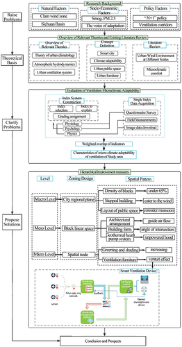
3.1. Technology roadmap ()
Figure 5. Technology roadmap.
3.2. Research method
3.2.1. Literature research
The relevant works in the literature on urban microclimate environments were thoroughly studied to understand the theoretical connotations and clarify the research focus and the feasible path in combination with the overview of the study area. The influencing factors affecting the urban public space wind environment were sorted out and screened, and then an evaluation index system was built.
3.2.2. Weight measurement
As mentioned above, human microclimate adaption involves a wide range of aspects, corresponding to various factors. Furthermore, some links between the qualitative analysis render it difficult to meet the accuracy requirements of the follow-up studies. Hence, the analytic hierarchy process (AHP) was selected in this work to calculate each index’s weight value from experts’ subjective experience.
3.2.3. Field survey
The data obtained from the geographic information platform and the remote sensing images were corrected by conducting field surveys. The basic situation of the public space in the study area was investigated, and drawings were plotted. In addition, the field temperature, wind speed, and other data were measured.
3.2.4. Questionnaire survey
Through the questionnaire survey, the subjective feelings of all kinds of people in the survey area about their public space microclimate and the public facilities were understood, as well as their intentions and suggestions to improve the public space microclimate.
3.3. The comprehensive evaluation system of wind environmental suitability in summer
The basic index selection principle was followed (Xue et al. Citation2012). Moreover, according to the existing works in the literature, three criterion layers of physics (Xulu and Binyi Citation2020; Rui Citation2017; Meiling et al. Citation2022; Yuanyuan and Weiquan Citation2022; Minzhen et al. Citation2016; ASHRAE Citation1992; Tao Citation2015; Dahai and Rong Citation2022), physiology (Xulu and Binyi Citation2020; Yuan, Chao, and Enrong Citation2022; Minzhen et al. Citation2016; Weiwei et al. Citation2011; Zhen Citation2008; Yuanchao and Shuxian Citation2022; Lan Citation2012; Ying et al. Citation2018; Wanhui Citation2010) and psychology (ASHRAE. ANSI ASHRAE Standard Citation1992; Liang Citation2006; Yulang Citation2014; Chao Citation2021) were applied to the comprehensive index system by grades.
3.3.1. Basic index selection principle
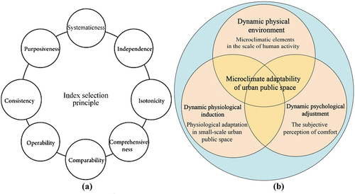
(1) The principle of purpose ()
Figure 6. Indicator system (a: indicator selection principle; b: triarchic theoretical framework of urban street microclimate comfort based on dynamic physiological induction, dynamic physical environment, and psychological adjustment coupling interaction.).
Any comprehensive evaluation has a purpose and an evaluation index. The system should embody the purpose and meet the comprehensive evaluation requirements.
(2) The principle of systematicness
During the process of establishing the comprehensive evaluation index system, the organic relation between each index should be fully considered, while each aspect of the evaluated object is considered an indivisible organic whole.
(3) The principle of consistency
The selected number and the statistical caliber of each evaluation index in the comprehensive evaluation index system should ensure consistency in each element of the index.
(4) The principle of independence
The overlap and statistical correlation of the evaluation indicators in concept and extension should be reduced as far as possible, and the evaluation indicator group with strong independence, representation, and maximum contribution should be selected.
(5) The principle of isotonicity
All indexes reflecting the characteristics and degree of the research object, its value and characteristics, and the degree of the size of the advantages and disadvantages of the evaluation method were the same. Generally, in the specific choice of requirements, such as index, reverse index, or neutral index form, indexing in the application of the same problem in different directions should be avoided, due to the difference in the direction that can cancel each other out. The reflection of the essential character of a thing also confuses the situation. When positive, negative, and neutral indicators appear simultaneously in an evaluation index system, they should also be converted in the same direction for evaluation.
(6) Principle of comprehensiveness
To ensure the objectivity and accuracy of the results during the comprehensive evaluation, as many evaluation indicators as possible should be selected. The main goal is to reflect the basic characteristics of all aspects of the evaluated things in the initial establishment of the index system. As a result, there will be a screening room for the final determination of the index system.
(7) The principle of comparability
When evaluation indicators are selected, attention should be paid to the scope of indicators and the principle of longitudinal and horizontal comparison of the various accounting methods. The vertical comparison should also be examined during the evaluation of the same thing in different periods, while horizontal comparison should be taken into account while evaluating different things in the same period.
(8) The principle of Operability
The selected evaluation index should not only conform to the purpose of comprehensive evaluation but also should be supported by the relevant data. The evaluation index data should be easily obtained. Otherwise, the established index system can only be shelved, and the purpose of a comprehensive evaluation could not be achieved. Thus, it is not helpful to guide the practical work.
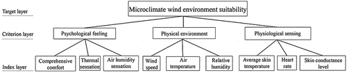
3.3.2. Index selection and construction
An accurate evaluation of the suitability of the microclimate wind environment in the study area is considered the basis of microclimate adaptation. Based on the “triarchic theoretical framework of the urban street microclimate comfort and the dynamic physiological induction, dynamic and psychological adjustment coupling interaction,” which was proposed by Peng Xulu and Liu Binyi, the criterion layer of the comprehensive evaluation index system of microclimate wind environment suitability was developed. The selection of indicators was based on the relative works in the literature on the correlation of physical, physiological, and psychological factors affecting microclimate (Weihua Citation2000; Weiwu et al. Citation2019).
In the study of microclimate in urban public space, instruments like cardio tachometers are also used to measure the physiological data of the human body and environmental meteorological data. The main goal is to verify the correlation between some physiological reactions of the human body and the related environmental meteorological factors. The comfort gradient of the wind and the thermal environment through the subjective psychological feelings of the testers in a particular test environment has been also directly reported in the literature. Factors with a high correlation with microclimate wind environment were selected from physical, psychological, and physiological aspects as evaluation factors, whereas the indicators according to the principle of index selection were chosen.
The evaluation index system can be divided into three levels: target, criterion, and index. The target layer is “the suitability of the public space microclimate wind environment in summer, Chengdu.” The criterion layer includes “physical,” “physiological,” and “psychological.” The index layer screened out nine influencing factors: Thermal sensation, Air humidity sensation, Comprehensive comfort, Average skin temperature, Heart rate, Skin conductance level, Wind speed, Relative humidity, and Air temperature ().
3.3.3. Grade and assign values
()
Table 3. The classification and assignment of each index of the comprehensive evaluation of microclimatic wind environmental adaptability.
Table 4. Construction of judgment matrix of the structural model for assessing microclimatic wind environmental factors.
Table 5. The result of the judgment Matrix of the structural model for assessing microclimatic wind environmental factors.
3.3.4. Weight determination
The analytic hierarchy process was used to determine the weight of each index. In the early 1970s, an American operations scientist Saaty proposed the famous Analytic Hierarchy y Process (AHP). The analytic hierarchy process (AHP) is actually a decision-making method that decomposes the elements related to decision-making into the levels of goals, criteria, and schemes. Then, both qualitative and quantitative analysis was conducted on this basis. This method has the comparative advantages of system, flexibility, and simplicity ().
Figure 7. Hierarchical structure model.
Build a hierarchical structure model
Judgment matrix Construction
According to the hierarchical structure model, the factors that are contained in each level adopt the form of pairwise comparison to establish a unified comparison criterion.
(3) Consistency test
Due to the complex factors affecting the microclimate environment, there will be large differences between the front and the back scales when the evaluator compares the two indicators. The inconsistent questionnaires can be automatically corrected by using the maximum direction algorithm. The consistency ratio was 0.2834 before the correction and 0.0279 after the correction.
(4) Judgment matrix results
4. Discussion: systematic improvement strategy of smart ventilation in urban public space
From the perspective of human safety and comfort, during the planning and design of the urban public space, all the changes and problems of the microclimate environment, which are caused by the artificial construction environment can establish a mutual influence relationship with the wind environment. On top of that, the appropriate wind environment will be an important content of the optimization construction of the urban microclimate environment in the future. Currently, the passive ventilation measures of urban public space often focus on software simulation, wind corridors, and street building forms, but the effect is not obvious in the actual microclimate environment improvement. Based on the summary of existing research literature on smart cities, passive energy-saving buildings, urban planning and design, wind environment technology analysis, etc., combined with practical project cases, we further studied and presented the following design solutions in three dimensions——macro city regional plane, meso block linear space, and micro spatial node ventilation facilities (). Solutions for each dimension can be combined in practical applications according to local conditions and different types of space. Different optimization strategies were adopted comprehensively to promote the formation of a suitable urban wind environment (Suiping et al. Citation2016).
Table 6. The design elements correspond to different wind environment problems and the optimization goals of the wind environment.
4.1. Macro level – city regional plane
4.1.1. Reduce the building density of blocks
The relatively high-density form of buildings in the urban environment will greatly reduce the space for air circulation. Thereby, it is particularly important to control the building density of the blocks reasonably, requiring that the building density should not exceed 65%.
4.1.2. Stepped building height design
The staggering change of the building group height helps to change the wind direction and avoid the retention of airflow. If feasible, the building height should be changed to a stepped building height in the direction of the prevailing summer wind, which can greatly improve the ventilation of the building group.
4.1.3. Reasonable layout of public open space
It is generally required that open squares, parks, green spaces, and other types of open spaces in blocks should be arranged in the windward position of the prevailing wind direction in summer to ensure A good ventilation environment in the open public space.
The layout should be also avoided in the windward position of the prevailing wind direction in winter to prevent the direct inflow of the winter wind.
At the intersection of streets, the retrofit distance of buildings should be appropriately increased, and street squares or green spaces should be opened to facilitate the distribution of airflow in the different wind directions and avoid the formation of vortex zones.
4.2. Meso level – block linear space
4.2.1. Architectural arrangement
The building’s obstruction of airflow can change the direction of the wind. Therefore, the proper arrangement of the buildings can effectively direct the air near the building in the desired direction. More specifically, the airflow can be directed down to the ground or directing the horizontal airflow sideways can be directed into the leeward space of the building or the leeward street (Fei Citation2022; Yuhan and Binyi Citation2022).
The structure of the staggered: the buildings along summer can prevail in the wind direction when they are staggered. Particularly, the back can be prompted by the airflow in front of the building on both sides of the construction. Moreover, the airflow can be guided into the space between the buildings or allow the wind to blow to the back of the spaces between the buildings through the front of the building. As a result, air circulation plays an important role in promoting the buildings.
The relationship between the high-rise building podium and the main pedestrian area is also of great importance: The podium of the high-rise building plays an important role in optimizing the influence of the high-rise building on the wind environment of the main pedestrian area around. Various design methods can be adopted according to the different wind environment conditions (Yingsheng Citation2013).
When the main pedestrian area is located within the coverage range of the order flow zone on both sides of high-rise buildings, the high-rise buildings (especially super high-rise buildings) should be avoided to be placed directly adjacent to the main pedestrian area. The podium can be used to form a buffer space for the downdraft along with the high-rise building to prevent the downdraft from further increasing the wind speed in the corner flow zone. Furthermore, when the main pedestrian area is located at a right angle to the prevailing wind in the summer and is in the lee, the high-rise building facing the main pedestrian area can be aligned with the edge of the podium to guide the wind down to the ground. Hence, the airflow is avoided descending to the podium’s roof and cannot reach the ground.
(3) Optimization of the linear arrangement and combination of high-rise buildings: there are two kinds of linear arrangements and combinations of high-rise buildings that are perpendicular to the wind direction (or the intersection Angle is greater than 30°) and parallel (or the intersection Angle is less than 30°). Among these, the vertical situation should be avoided. Otherwise, may form a “wall of wind effect” that can cause extensive lee eddy area on the back of the building, as well as on both sides the angle of strong wind flow area can also be formed. Therefore, the divided city blocks should avoid such long and straight shape blocks, and the design of the single direction and “wall” type of high-rise building group layout should be followed.
At the same time, whether vertical or parallel, the linear layout of high-rise buildings should be as far as possible to keep enough distance between them, regardless of the vertical or parallel configuration. The goal is to reduce the obstruction to airflow. In addition, the skirt room of high-rise buildings should also set aside enough width for air circulation near the ground. As a result, the wind environment of the lee space can be improved. In parallel, the high-rise buildings can be made into a staggered layout and height change along with the wind direction to promote airflow into the buildings and the leeward space. Thus, a downdraft can be formed to reduce the impact of pedestrian height in the wind shadow area.
(4) A single high-rise building layout optimization: when there are square, green spaces in a park, the formation of public space, such as a high-rise building layout, should be avoided on the prevailing winds in the summer of wind quantity. Otherwise, the tall buildings and the green space in the square or park space form the leeward eddy current area of a large area, which can induce no wind conditions. Thereby, the public space comfort will be significantly reduced. When the land is mostly composed of multi-story or low-rise buildings, the high-rise buildings should be located downwind of the prevailing wind direction in the summer and upwind of the prevailing wind direction in winter. This is conducive to guiding the upper airflow down to the near-ground space of the land in summer and can also play a certain role in windbreak in winter. However, in the opposite case, where the high-rise building is located upwind of the prevailing wind direction in the summer and downwind of the prevailing wind direction in winter, the wind shadow area may be formed in the summer. Besides, a large amount of downdraft may be formed in the winter, which is not conducive to ventilation in summer and wind prevention in the winter.
4.2.2. Building orientation and form
Building orientation: To effectively reduce the building’s obstruction to air circulation, the long side of the building should also be parallel to the prevailing wind direction, or the Angle of intersection should be less than 30° under the condition that the single building meets the sunshine and indoor ventilation.
A form of high-rise buildings: The basic principle of the spatial wind environment optimization around high-rise buildings is to avoid wind speed exceeding the wind comfort threshold of 5.0 m/s in the angular flow area at pedestrian height. As a result, the influence range of wind shadow area at pedestrian height can be minimized.
4.2.3. Geothermal heat pump system
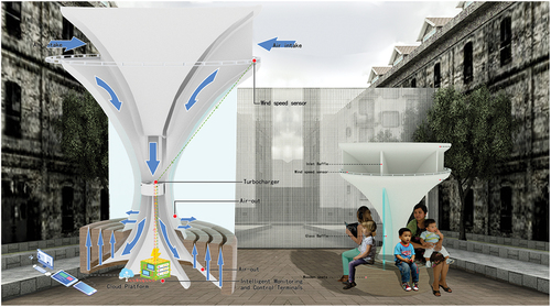
To solve the block’s ventilation problem and meet the street’s landscape requirements, the concept of “ventilated urban furniture” was proposed here (). Including but not limited to urban seats, streetlights, etc., it can become a good medium to improve the microclimate of public space.
The whole street, or even the block, can be considered a building from a systematic point of view. The development and utilization of geothermal energy is an inevitable choice to efficiently reduce carbon dioxide emissions and cope with imminent climate change. The theoretical research and practical application of passive building internal wind environment have confirmed that the chimney effect generated by ventilation shafts can change the internal wind environment of buildings. The building envelope adopts a double-glazed curtain wall with “Fishmouth” construction facilities, which can enhance the airflow and human comfort temperature control inside and outside the building. If the ventilation shaft inside the building is set at the outer envelope interface of the building, then for the interior and exterior space of the building, the double-skin envelope structure of the building is like the exhaust system of the “three-cavity flue,” and the roof is equipped with a non-powered hood, which can accelerate the improvement of the microclimate environment at the human scale outside the building. For cities, buildings can be seen as ventilation facilities for improved urban microclimates. The measures already in place in the building itself to improve the wind environment can still be used to improve the microclimate environment of public spaces outside the city. However, it can be predicted that the design strategy of improving the wind environment of urban public open space through the building itself is feasible and in line with the urban acupuncture systematic theory under the premise of reducing energy loss although this priori assumption is not currently applied in urban design.
At the same time, by considering that the land is a natural insulation layer, the air supply can also play the role of transferring temperature. In other words, it is warm in winter and cool in summer. So, overall “Urban ventilation furniture” can be combined with the ground source heat pump, the building roof ventilation facilities, passive ventilation inside the building, the street set “reverse unpowered hood, suction horn,” and so on. The wind speed can be further maximized through the Venturi effect by incorporating the prevailing wind, which is not large. More specifically, the wind is sent to the branch pipe through the main pipe. Consequently, the turbine in the branch pipe circulates the air and supplies it through the “urban ventilation furniture.” We must underline that instead of running on electricity alone, the turbines are driven by wind pressure in their branches, which is anticipated to greatly reduce the total energy consumption. Integrating renewable energy into smart city energy systems can also be considered a wise strategy for achieving a further healthy and sustainable environment.
4.3. Micro level– spatial node
4.3.1. Urban ventilation furniture
In the face of the COVID-19 pandemic and the inevitable normalization of future outbreaks, the distance people should maintain in public spaces should also be considered. As a result, in the design of urban ventilation furniture, appropriate consideration between the different groups should be paid to maintain a certain space distance.
When the wind from all directions enters the air inlet, it will induce the rotation of the anemometer the current wind speed data will be transferred to the terminal. Next, the terminal will send the command to the turbine to change the rotation speed and replenish both the air and supply. This can be achieved through the holes at the bottom and back of the seat after the specified wind speed. Finally, the feedback results from the anemometer are sent to the terminal, and the data are shared through the cloud platform. The structure design of the air inlet and outlet of the ventilation seat forms wind pressure. The internal setting of the ventilation louvers rotation angle and turbine rotation air volume can control wind speed, wind direction, etc… Occupants can control the wind speed of the seat itself microclimate environment, and other physical parameter settings through the mobile phone APP or the WeChat mini program of the sites, which can improve user comfort and increase outdoor stay time in the hottest month in Chengdu.
The layout of ventilation seats in space nodes, street linear space and overall area can realize the regional ventilation solution of points, lines, and surfaces. Taking everything into account, different forms of “ventilated urban furniture” may change. However, the application mode and operating principle remain the same. Through air disturbance and wind pressure ventilation for furniture in different cities can be realized. Nevertheless, ultimately the mode of the “monitoring-control-feedback-cloud platform” remains unchanged.
In addition, if the requirements for the outdoor microclimate environment are high, the ground source heat pump, as a feasible solution for low-carbon and energy-saving buildings, can also be implemented in the adjustment plan of the microclimate environment in urban areas, just like the principle of laying water pipes to equidistant water spray in local areas to achieve urban dust reduction. However, the concept needs to be further studied at a later stage. The fan coil needs to be laid above ground in advance to incorporate into the overall planning of the ventilation improvement area.
4.3.2. Optimization of greening and shading
Increasing afforestation and shade are considered areas of the city wind environment to optimize the supporting measures. Moreover, by increasing the green vegetation coverage and providing shade hard soft space, the urban environment of the human body’s thermal comfort can be effectively improved. Thus, the demand for high wind speed can be reduced. At the same time, the green space can also provide the area with fresh cool air, which is one of the most important measures to improve the microclimate adaption of the human body ().
Figure 8. Urban ventilation furniture case.
Large squares, green spaces, parks, and other recreational lands encourage the existence of more plants, especially tall and lush trees. Through the compound effect of canopy shading and transpiration, a significant cooling effect can be thus formed, which is conducive to regulating the urban climate. In the small street green space, square, or building retreat space, more shrubs should be planted on the lawn, water bodies should be arranged, whereas tall and luxuriant trees should be planted directly. On the contrary, dense tree arrays should be avoided to hinder ventilation.
Tall and dense trees should also be planted in pedestrian streets and walkways to block the sun, reduce the temperature, and filter pollutants. Nevertheless, at the same time, the ventilation of pedestrian areas should not be obstructed. If a green walking network separated from the vehicle traffic system can be established, it will provide pedestrians with a more comfortable walking and sightseeing experience.
Table 7. The analysis of the ventilation-adapted layout of the public spaces at Eastern Banlieue memory industrial park.
5. Case study
5.1. Analysis of eastern banlieue memory industrial park
The Eastern Banlieue Memory Industrial Park area is composed of the Eastern Banlieue Memory and the surrounding commercial pedestrian streets. It is considered a multi-cultural park with music, art, drama, photography, and other cultural forms, which was rebuilt on the site of the former state-run Hongguang electronic tube factory, the art culture exhibition settlement, the literature, and Art Creation Exchange Park, Chengdu Culture Creative Industry Highland.
The area has been completely transformed from an old industrial site into a commercial and cultural centre as part of the urban renewal project in Chengdu. The newly built area has attracted a relatively large number of people and tourists from the surrounding areas. However, now its popularity has declined considerably. With the COVID-19 outbreak, the drama club and the performance have stopped, and only the coffee shop is still open. The service population from the original mass, and the neighbourhood gradually became clocked in.
In addition to the industrial development, it is believed that other factors that do not attract the surrounding population including the fact that people in the area are not well adapted to the microclimate of the area, play a crucial role. As a typical industrial-to-commercial park, it was examined as an individual case of this microclimate adaptation. ()
Figure 9. Eastern Banlieue Memory park field investigation record (a: The status of roads in the eastern Banlieue s memory area; b: The current situation of memory greening in the eastern Banlieues; c: Height map of the eastern Banlieue s memory building; d: Eastern Banlieue Memory questionnaire area point).
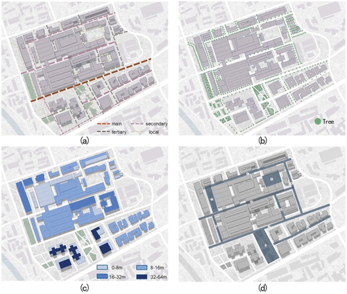
5.1.1. Road status quo of Eastern banlieue memory industrial park
The roads in the Eastern Banlieue Memory Industrial Park are axially extended. Thus, the wind environment in this area is greatly affected by road direction, the linear layout of buildings, and the vertical height of the buildings. Road downwind scales, road downwind angle, and road development axis are closely related to the regional wind environment. If the prevailing wind direction of the road market is vertical, the interaction between the road and the natural atmosphere could be intense (Shuyu et al. Citation2022). On top of that, its small depth makes it easy to reach the natural wind. On the other hand, if the prevailing wind direction is parallel to the expansion direction of the road, a larger scale of the urban axial expansion along with the prevailing wind direction will induce a smaller smoothness of the airflow inside the city (Jun and Ying Citation2022).
The road is a relatively smooth underlying surface, while the street can be used as a ventilation corridor to make the ventilation environment more suitable. However, the main roads of the ventilated corridor can only be used as lanes for broadening to improve the wind environment. As a result, other microclimate factors should be considered to improve at the same time. Particularly, during the common optimization on both sides of the street, various functions should be carried out, such as setting the streets green, developing a green park, or low-rise low-density construction. The main goal is to produce a suitably ventilated corridor to improve the humidity, temperature, and microclimate and add ecological entertainment, leisure, and other spaces. The secondary road not only takes on the function of traffic but also significantly affects the microclimate environment of air circulation in the block to a great extent. The secondary road is directly related to the surrounding park green space, rivers, and lakes to introduce the cold air generated in the surrounding environment (Rangwala et al. Citation2018).
The ventilation environment of a road is also related to its width and direction. On top of that, the scale and layout of buildings within a certain distance on both sides of the street will also have an impact on the wind environment. Rational planning of the angle relationship between the road orientation and urban dominant wind and the layout of the buildings around the road can effectively organize the flow of wind (Li et al. Citation2018; Xianhui Citation2022). From a relatively suitable wind environment, the road status in the Eastern Banlieue Memory Park area is divided into four grades for wind environment analysis.
5.1.2. Analysis of architecture and greening in the Eastern Banlieue memory industrial park
In the external space of the area, natural ventilation is very important for green energy saving and sustainable urban development. The local wind environment inside the area is mainly related to spatial elements, such as streets, building enclosures, squares, and greening organizations. When the wind passes through urban streets and buildings, a constant pressure difference will be generated on both sides of the air passage to generate the airflow. The two main reasons for the pressure difference in airflow are thermal and wind pressures, and there is no direct relationship between them, such as proportion (CHEN et al. Citation2018; Zhou and Guang Citation2001; Yinghan et al. Citation2015).
The investigation of the urban wind environment at the regional level is different. There are larger differences in the core content of the vertical height above the ground, and the urban wind environment is mainly examined for the city streets near the ground wind field (Guangtao et al. Citation2005; Zhongzhong and Yingxin Citation2017). In addition to the restriction of the weather system and its topography, and also around the streets and environment characteristic of itself, the influence of the horizontal and vertical differences in wind environment is also quite important. The relatively complex, wind environment can be easily changed. Due to the structure of the block, each wind environment has a different airflow between the buildings. The public space, the location, and its height will also be around the building space, forming interference, and changing the wind environment. The people in the public space obviously feel the difference in the buildings around the green shade, which is also an important part of memory. According to the east wind environment present situation analysis, the increase in afforestation and shade are areas of the city wind environment that can be used to optimize the supporting measures. By increasing the green vegetation coverage and providing shade hard soft space, the urban environment of the human body’s thermal comfort can be effectively improved. Thus, the demand for high wind speed can be reduced, and the green space at the same time can also provide the area with fresh, cool air (Yalan et al. Citation2022; Junyan et al. Citation2022).
5.2. Status quo status of the field survey
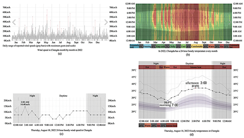
The questionnaire survey and field survey data comparative analysis of the status quo were combined in the field survey. First, through a comprehensive comparison of the road landscape and the building nodes in Eastern Banlieue Memory Industrial Park (), the public space inside the case area was divided into 10 points to improve the efficiency of the survey (). The relationship between the human body sensation and the wind environment was statistically analyzed by questionnaires and field-measured data. The temperature, humidity, illumination, wind speed, wind direction, and other real-time data at different points were measured by using a temperature and humidity meter, illuminator, anemometer, etc. (). The wind speed distribution in Chengdu is relatively average between months. Meanwhile, the frequency of wind speed distribution is relatively fixed (). The number of hours with outdoor wind speed less than or equal to 3.33 m/s in Chengdu accounted for 97% of the total time of the year, and the measured data on August 18, the hottest month, showed that the average daytime wind speed was 0.39 m/s under microclimate conditions at ten field test points ().
Figure 10. The measured data in Eastern Banlieue memory industrial park.
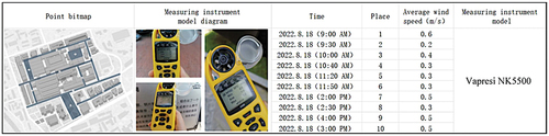
Figure 11. Temperature and wind speed maps of Chengdu in 2022 (a: Wind speed in Chengdu month by month in 2022; b: Hourly temperature in the 24-hour month by month, August 18th, 2022; c: Hourly wind speed in 24-hour, 2022; d: Hourly temperature in 24-hour, August 18th, 2022).
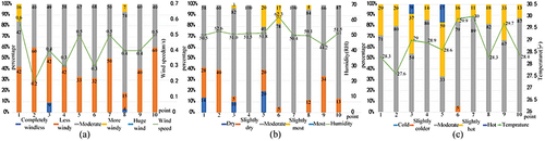
Combined with the data, on the basis of the statistics of the questionnaire results, part of the current situation analysis of the Eastern Banlieue Memory Industrial Park was obtained. As can be observed from , it was concluded that the human body felt the most comfortable at each point when the wind speed was 0.3 ~ 0.5 m/s, which was also an important index data in our improvement strategy. In , it can be seen that when the humidity is in the range of 50. 5 ~ 51.5 %rh, people feel more comfortable, while when the humidity reaches 60 %rh and above, people begin to feel humid. In the statistics in , it can also be observed that when the temperature is not higher than 28.3 degrees Celsius, 72.4% −82.1% of people feel relatively comfortable. On the contrary, when the temperature reaches 28.6 degrees Celsius, 66.7% of people’s thermal comfort decreases, and they begin to feel hot.
Figure 12. Questionnaire results (a: study the relationship between wind speed at different points and wind speed felt by the human body; b: study the relationship between humidity at different points and the human body’s perceived humidity; c: the relationship between temperature and thermal sensation at different study points).
5.3. Wind environment simulation in the Eastern Banlieue memory industrial park
5.3.1. Wind environment simulation method
Numerical simulations were conducted to solve the wind field around the building movement law following the dynamic equation. The process of simulating the real wind environment around a building is called computer numerical simulation, which is commonly known as computational fluid dynamics (CFD). The numerical simulation tool used in this work was the PHOENICS software package developed by the CHAM Institute of Imperial College London. Thousands of experimental verification cases, numerous turbulence models, and numerical difference schemes guarantee the reliability of the simulation results of the software, which can be applied to the simulation of wind environments in urban blocks.
Value simulation techniques can be found in relevant monographs and literature. Phoenics is the world’s first commercial computational fluid and computational heat transfer software. It was developed by professor D. B. Spalding, the founder of computational fluid and computational heat transfer. He is also a fellow of the Royal Academy of Engineering and has more than 40 years of experience. A series of parabolic hyperbolic or elliptic numerals for describing the flow and heat transfer characteristics can be simulated using PHOENICS. It has been applied to several scientific disciplines, including aircraft, marine engineering, industrial design engineering, building, environmental sciences, energy dynamics, and chemical engineering. In addition, PHOENICS can be used for many disciplines and fluid motion simulations. Its official summary of 26 application areas is as follows: Aerodynamics, Burner, Cyclonic, Duct flow, Electron cooling, Fire engineering, Geophysical study, Heat exchanger, Jet, Kiln, Lung, Mold filling, Nozzle, Oil slick, Plume dispersal, Quality of air, Rocket, Stirred tank, Tundish, Urban pollution, Vistol aircraft, Wet cooling tower, NOx reduction, Yacht, Zeppelin.
5.3.2. Wind environment evaluation index
was taken as the wind speed index of pedestrian height wind environment evaluation in urban blocks by referring to the existing standards and the specifications in China. According to this index, when the wind speed is lower than 1 m/s, pedestrians basically cannot feel the wind, and the city block under this wind speed is called the wind shadow area. However, when the wind speed is between 1 m/s and 5 m/s, is regarded as the wind speed range of a comfortable wind environment. We must underline that 5 m/s is the boundary index to judge whether the wind speed is comfortable at the pedestrian height. The existence of a wind speed exceeding this value can be regarded as uncomfortable.
Table 8. Results evaluation indicators combine pedestrians’ wind speed with the relative static wind speed of air pollutants.
When the wind speed is between 5 m/s and 7.3 m/s, the wind environment at the pedestrian height has reached an uncomfortable degree. However, it will not affect people’s normal activities. 7.3 m/s is the criterion to judge whether the wind speed is too large to affect people’s normal activities. When the wind speed exceeds this value, the Pedestrian height wind environment in the urban built environment will greatly affect people’s normal behavior. Interestingly, when the wind speed is greater than 7.3 m/s, the wind environment will reach a severe degree, which seriously affects the normal activities of pedestrians.
In practical applications, for relatively public areas with more activities in urban blocks, for example, 5 m/s is suitable to judge whether the wind speed is comfortable in urban built-up areas, such as commercial land, green square, residential area, and administrative office as a reference index. However, the air quality of urban blocks, such as factory production protection areas and park green open space, is relatively low. For the case that harmful gases and other substances may be produced in the urban space or the built-up blocks, where people seldom go to and have a relatively low population density, the boundary value of 7.3 m/s can be considered as a reference index to judge whether the wind speed will affect people’s normal activities.
5.3.3. Analysis of wind environment simulation results
In this case, 5 m/s can be used as a reference index to judge whether wind speed is appropriate. According to the acquired wind environment computer numerical simulation results of this time (), the dominant wind is poured into the park through the construction of the south road. From the view of the street-facing interface of the park, due to the original industrial site, the building is larger, and the wind field is less connected. As a result, the inlet wind speed in most park areas is below 0.6 m/s. Moreover, the average wind speed in the whole area is only 0.9 m/s, and the comfort level of pedestrian height wind environment in the case area is mostly a winding shadow area. This result indicates that pedestrians cannot feel the wind in the case area and the quiet wind frequency is very high, which also indicates the significance of the adaptive transformation of the microclimate wind environment.
Figure 13. Analyses of wind environment by using Phoenics software (a: Phoenics software interface diagram.B: wind speed simulation at 1.5m pedestrians height in the study area).
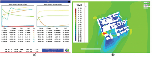
Figure 14. Installation layout point map.
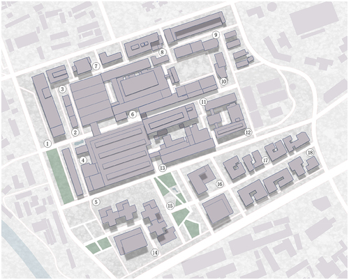
Figure 15. Working status of ventilation seat. (a: without turbo; b: with turbo).
5.4. Wind environment transformation of Eastern Banlieue memory industrial
Based on the current situation analysis of the building roads and greening in the Eastern Banlieue Memory Industrial Park and the computer numerical simulation analysis of the Eastern Banlieue Memory area, the “urban furniture” proposed in this work was preliminarily arranged, as shown in , to improve the quality of the wind environment in the Eastern Banlieue Memory area.
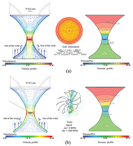
We predict that the ventilation seats will be able to bring low or even calm wind through vortices and the Venturi effect to a comfortable wind speed at the outlet. The combination of smart cities can be out of customs and regulated.
Using cradle CFD software, the method of steady-state AlE is used to simulate the ventilated seats. The model is simplified, and the analysis model is established. The number of grids is 140,237. Let the inlet velocity be 0.5 m/s (Incompressible flow 20 ℃), and the outlet is a static pressure outlet. When the turbine rotates at 0 RMP (the turbine does not work), the internal fluid state of the ventilated seat when it works is shown in (). Due to the Venturi effect, the wind speed in the outlet area can reach 3–6 m per second; When the turbine speed is 1500 RMP (common table fan: 500–1500 rpm), the internal fluid state of the ventilation seat when working as shown in (), the outlet can reach 10 m/s or more.
6. Conclusions and prospects
This work on the application of micro-climate environment improvement measures is universal. The involving improvement of human ventilation comfort of public space is also involved, which can be applied to urban public spaces.
Under the current global climate change, the demands for comfort in the urban public space micro-environment are increasing, which involves three elements: the hard physical space environment, the dynamic physiological sensing, and the human body’s comfort and psychological feeling. Therefore, the evaluation standard of physics-physiology-psychology comprehensive factors and the contradiction of lacking universality in the specific research in a certain region can be better solved by design.
According to previously reported works in the literature, the measures to improve the wind environment at various scales were summarized. Urban ventilation furniture was proposed and designed to enhance the future smart city’s urban ventilation environment.
According to research on the current wind environment in Chengdu, the axis layout of the Eastern Banlieue Memory area was found as a typical case, and a case study was conducted. Finally, the combination of the geothermal heat pump is achieved. A method for the system was also introduced to accurately control the wind environment of the blocks smartly and accurately and even the entire city. The research conclusions are as follows:
6.1. Conclusion of Eastern Banlieue memory area case study
The human body felt the most comfortable at each point when the wind speed was 0.3 ~ 0.5 m/s.
When the humidity is in the range of 50. 5 ~ 51.5 %rh, people feel more comfortable, while when the humidity reaches 60 %rh and above, people begin to feel humid.
Most people feel relatively comfortable when temperatures are not higher than 28.3 degrees Celsius. In striking contrast, when the temperature reached 28.6 degrees Celsius, more than half of people’s thermal comfort decreased, and they began to feel hot.
Ventilation art installations can attract people to urban public spaces to a certain extent.
The comfort level of the pedestrian height wind environment in the case area is mostly a wind shadow area, indicating that pedestrians basically cannot feel the wind in the case area, and the quiet wind frequency is very high.
Applicability of the wind environment improvement
At the large-scale (City-level) level, the urban wind environment was analyzed, forecasted, and adapted to urban climate planning through relevant technical software. At the mesoscale level (block level), the ventilation efficiency of urban areas can be satisfied with index control or spatial transformation of block and street space. At the small-scale level (building level), the wind environment of the building group and surrounding open space was analyzed and simulated to find out the change rules of wind pressure and airflow.
The form of urban ventilation furniture is changeable. Although the different forms of “ventilation urban furniture” may change, but the mode remains the same. With the help of the ground source heat pump, air supply for furniture in different cities can be realized. However, ultimately the mode of the “monitoring-control-feedback-cloud platform” remains unchanged.
Urban ventilation furniture alone cannot have a great impact. Nevertheless, it can be combined with the ground source heat pump system to expand the scope of influence and with the cloud platform to achieve real-time monitoring and regulation and realize smart ventilation.
6.2. Follow-up work outlook
In this work, we start from the design level combined with technical measures to try to carry out three dimensions of overall systemic exploratory research. It is from the perspective of overall planning design and improvement of spatial microclimate suitability to carry out, and it is not only a completely technical project on any single point.
The follow-up research of this work can be carried out around the following points:
We suggested that more ventilation devices of different types of urban furniture can be designed based on this principle. In particular, the use of wind pressure and wind direction, combined with site design, can carry out some wind landscape installation design that brings people spiritual pleasure, which is worthy of further study.
It was proposed to combine the ground source heat pump system to control the ventilation environment of blocks and even cities. The specific pipeline layout, detailed design, and cost budget need to be further studied.
Improving the ventilation micro-climate environment in urban public spaces is a systematic project, which is different from transforming the ventilation physical environment of relatively confined spaces in buildings. It requires an all-around overall system design. In the planning layout, building boundary form, building interior and exterior ventilation facilities coordination, early laying of ventilation ducts before ground construction, ventilation environment simulation, and simulation all need to be designed and investigated as a whole before construction. The coordination between passive ventilation measures at different scales in the same regional project needs further research.
Acknowledgements
The authors are grateful to the Foreign Affairs Office of Chengdu Municipal People’s Government and the World Smart Sustainable Cities Organization, State Key Laboratory of Geohazard Prevention and Geoenvironment Protection of Chengdu University of Technology, MSC Software Hexagon (Beijing) Company for support training opportunities and software analysis.
Disclosure statement
No potential conflict of interest was reported by the author(s).
Additional information
Funding
Notes on contributors
Hao Xie
Hao Xie is the competition team member of “the World Youth Smart City Innovation Competition” (Ranked in the Top 3 of the Chinese Zone) which hold by the WeGo organization and major in urban and rural planning at the college of tourism & urban-rural planning, Chengdu University of Technology, China. Yanju Li Yanju Li is the corresponding author and an associate professor at the college of tourism & urban-rural planning, Chengdu University of Technology, China. Her research interests are urban and rural human settlements and low-carbon healthy community planning and design. She is High-level overseas study talent in Sichuan Province, China. She is a communication reviewer for the National Natural Science Foundation of China, and this WeGo competition instructor.
Yongjie Liu
Yongjie Liu is the competition team member of “the World Youth Smart City Innovation Competition” (Ranked in the Top 3 of the Chinese Zone) which hold by the WeGo organization and major in urban and rural planning at the college of tourism & urban-rural planning, Chengdu University of Technology, China. Yanju Li Yanju Li is the corresponding author and an associate professor at the college of tourism & urban-rural planning, Chengdu University of Technology, China. Her research interests are urban and rural human settlements and low-carbon healthy community planning and design. She is High-level overseas study talent in Sichuan Province, China. She is a communication reviewer for the National Natural Science Foundation of China, and this WeGo competition instructor.
Peiqing Zhong
Peiqing Zhong is the competition team member of “the World Youth Smart City Innovation Competition” (Ranked in the Top 3 of the Chinese Zone) which hold by the WeGo organization and major in urban and rural planning at the college of tourism & urban-rural planning, Chengdu University of Technology, China. Yanju Li Yanju Li is the corresponding author and an associate professor at the college of tourism & urban-rural planning, Chengdu University of Technology, China. Her research interests are urban and rural human settlements and low-carbon healthy community planning and design. She is High-level overseas study talent in Sichuan Province, China. She is a communication reviewer for the National Natural Science Foundation of China, and this WeGo competition instructor.
Huanhuan Liu
Huanhuan Liu is the competition team member of “the World Youth Smart City Innovation Competition” (Ranked in the Top 3 of the Chinese Zone) which hold by the WeGo organization and major in urban and rural planning at the college of tourism & urban-rural planning, Chengdu University of Technology, China. Yanju Li Yanju Li is the corresponding author and an associate professor at the college of tourism & urban-rural planning, Chengdu University of Technology, China. Her research interests are urban and rural human settlements and low-carbon healthy community planning and design. She is High-level overseas study talent in Sichuan Province, China. She is a communication reviewer for the National Natural Science Foundation of China, and this WeGo competition instructor.
Enkang Xie
Enkang Xie is the competition team member of “the World Youth Smart City Innovation Competition” (Ranked in the Top 3 of the Chinese Zone) which hold by the WeGo organization and major in urban and rural planning at the college of tourism & urban-rural planning, Chengdu University of Technology, China. Yanju Li Yanju Li is the corresponding author and an associate professor at the college of tourism & urban-rural planning, Chengdu University of Technology, China. Her research interests are urban and rural human settlements and low-carbon healthy community planning and design. She is High-level overseas study talent in Sichuan Province, China. She is a communication reviewer for the National Natural Science Foundation of China, and this WeGo competition instructor.
References
- ASHRAE. 1992. “ANSI ASHRAE Standard 55-1992, Thermal Environmental Conditions for Human Occupancy.” Accessed 1 July 2022. https://xueshu.baidu.com/usercenter/paper/show?paperid=132f0av0wk3u0rv00s1y0jw0jm444985&site=xueshu_se
- Beixiang, S., Y. Junyan, and Y. Xiaofang. Accessed 7 January 2021. “Urban Design Strategy of Multi-Scale Urban Wind Environment Construction–Based on the Perspective of Urban Safety.” New Building 2021 (06). https://d.wanfangdata.com.cn/periodical/ChlQZXJpb2RpY2FsQ0hJTmV3UzIwMjMwMTEyEgx4anoyMDIxMDYwMTYaCGF2cnJwY3du
- Chao, W. 2021. “Study the Effect of Air Humidity on Human Thermal Comfort[d].” Xiangtan Science. Accessed 1 July 2022. https://kns.cnki.net/kcms/detail/detail.aspx?doi=10.27426/d.cnki.gxtdu.2021.001435&dbcode=CMFD
- Chao, R., Y. Chao, H. Zhengjun, Enrong, W., and W. Enrong. 2022. “Research on Urban Ventilation Corridor and Its Planning and Application.” Urban Planning Journal 2014 (3) 52–60. Accessed 1 July 2022. https://d.wanfangdata.com.cn/periodical/ChlQZXJpb2RpY2FsQ0hJTmV3UzIwMjIwNzE5Eg9jc2doaGsyMDE0MDMwMDcaCHFiYW5raDdy
- Chen, L., M. Zhang, Z. H. U. J, Y. Wang, and A. Skorokhod. 2018. “Modeling Impacts of Urbanization and Urban Heat Island Mitigation on Boundary Layer Meteorology and Air Quality in Beijing Under Different Weather Conditions.” Journal of Geophysical Research Atmospheres 123 (8): 4323–4344. Accessed 1 July 2022. https://www.scholarmate.com/S/NRvgev.
- Dahai, X., and Z. Rong. “Analysis of the Human Perception of Temperature, Humidity, Wind S, Peed and Clothing Index journal of.” Applied Meteorological Science 2000(04): 430–439. Accessed 1 July 2022. https://d.wanfangdata.com.cn/periodical/ChlQZXJpb2RpY2FsQ0hJTmV3UzIwMjIwNzE5Eg95eXF4eGIyMDAwMDQwMDYaCGY5MTE2czNm
- Datian, H. “Global Warming, Heat Island Effect and Urban Planning and Urban Design.” Urban Planning 2002(9): 77–79. Accessed 1 July 2022. https://d.wanfangdata.com.cn/periodical/ChlQZXJpb2RpY2FsQ0hJTmV3UzIwMjIwNzE5Eg1jc2doMjAwMjA5MDE3Ggg4Mm9ueXM3aA%3D%3D
- Fei, C. “Research on Wind Environment of High-Rise Building.” Architectural Journal 2008(2): 72–77. Accessed 1 July 2022. https://d.wanfangdata.com.cn/periodical/ChlQZXJpb2RpY2FsQ0hJTmV3UzIwMjIwNzE5Eg1qenhiMjAwODAyMDE5GghtZzVqZjV0OQ%3D%3D
- Feng, Y. “Urban Morphology and Microclimate Environment: A Review of Performance Simulation Pathways.” Urban Architecture 2015(28): 92–95. Accessed 1 July 2022. https://kns.cnki.net/kcms/detail/detail.aspx?doi=10.19892/j.cnki.csjz.2015.28.017
- Guangtao, W., W. Xiaoyun, M. Shiguang, Weimei, Jiang., Wenli, Guo., Chongping, Ji., Xianyan, Chen., Weimei Jiang, Wenli Guo, Chongping Ji, and Xianyan Chen. 2005. “Research and Application of Multi-Scale Assessment Technology System for Atmospheric Environmental Impact in Urban Planning.” Science in China (Series D: Earth Sciences) (S1): 145–155. Accessed 1 July 2022. https://d.wanfangdata.com.cn/periodical/ChlQZXJpb2RpY2FsQ0hJTmV3UzIwMjIwNzE5EhB6Z2t4LWNkMjAwNXoxMDE0Ggg0bGFweWJqZA%3D%3D
- Jing, W. 2012. “Research the Architectural Layout Strategy of Riverfront Block in Shenzhen Based on the Wind Environment[d].” Harbin Institute of Technology. Accessed 1 July 2022. https://d.wanfangdata.com.cn/thesis/ChJUaGVzaXNOZXdTMjAyMjA1MjYSB0Q0MjI5NDQaCDRnaXpvOG14
- Jinghai, L., G. Fei, and L. Zeng. 2019. “Study on Simulation and Application of Urban Wind Environment Based on CFD.” Smart City 5 (1): Accessed 18 March 2019. https://d.wanfangdata.com.cn/periodical/ChlQZXJpb2RpY2FsQ0hJTmV3UzIwMjMwMTEyEg16bmNzMjAxOTAxMDAzGgg5ZmliODJ0dg%3D%3D
- Junyan, Y., Z. Tao, and T. Ying. “The Technological Evolution of Urban Wind Environment Research and Its Evaluation System Integration.Nanfang.” Architecture 2014(03): 31–38. Accessed 1 July 2022. https://d.wanfangdata.com.cn/periodical/ChlQZXJpb2RpY2FsQ0hJTmV3UzIwMjIwNzE5Eg1uZmp6MjAxNDAzMDA2GghwcXZ6cTVyMg%3D%3D
- Jun, L., and R. Ying. “Construction of Urban Air Ducts and Their Design Control Guidance in Wuhan.” Planner 2014(8): 115–120. Accessed 1 July 2022. https://d.wanfangdata.com.cn/periodical/ChlQZXJpb2RpY2FsQ0hJTmV3UzIwMjIwNzE5EgxnaHMyMDE0MDgwMjAaCGp0NjR1d2xp
- Lan, X. 2012. “Mental Fatigue Assessment Based on Physiological Signal Detection and Analysis[d].”Southern Medical University. Accessed 1 July 2022. https://kns.cnki.net/kcms/detail/detail.aspx?dbcode=CMFD&dbname=CMFD201601&filename=1016024656.nh&uniplatform=NZKPT&v=2I3if9rV-ISuf5CStpoYWO9kSVtWh9hqQNLFUDnk7_OLM4QR-BKjzaMygNg-PqHb
- Liang, C. 2006. “Experimental Study on the Effect of Indoor Heat and Humid Environment on Human Physiology and Thermal Comfort[d].”Chongqing University. Accessed 1 July 2022. https://d.wanfangdata.com.cn/thesis/ChJUaGVzaXNOZXdTMjAyMjA1MjYSCFkxMDE3MzY2Ggg5cWs0amdkOA%3D%3D
- Lili, G. 2022. Study on Optimization Strategy of Urban Commercial District Spatial Form Under the Influence of Wind Environment ーー Taking Shenyang Commercial District as an Example [D]. Dong Bei University. Accessed 16 April 2022. https://www.cnki.net/kcms/doi/10.27007/d.cnki.gdbeu.2019.001058.html
- Li, C., Z. Wang, B. Li, Z. -R. Peng, and Q. Fu. 2018. “Investigating the Relationship Between Air Pollution Variation and Urban Form.” Building and Environment 147 (1): 559–568. Accessed 1 July 2022. https://www.sciencedirect.com/science/article/abs/pii/S0360132318303810
- Marwin, S., and Y. Junyan. 2019. “Association, Mechanism, and Governance: Research on Environment Construction of High-Density Urban Walking Suitability Based on Microclimate Evaluation.” International Urban Planning 34 (05): 16–26. Accessed 1 July 2022. https://kns.cnki.net/kcms/detail/detail.aspx?dbcode=CJFD&dbname=CJFDLAST2019&filename=GWCG201905003&uniplatform=NZKPT&v=jAK3P7a1zKdujv1nLyYgiMhj8IUYRFFaHqklWPGzYG0IA6stAbcRqsUB_M6lZ2y0
- Meilan, T. 2012. “Study the Effect of Relative Humidity and Wind Speed on Human Body Heat Sensation in Summer[d].” Chongqing University. Accessed 1 July 2022. https://d.wanfangdata.com.cn/thesis/ChJUaGVzaXNOZXdTMjAyMjA1MjYSB0QzMDUzMDEaCGk1ZmNvcDRu
- Meiling, S., H. Suqin, Y. Qing, and B. Hai. “Analysis of Static Wind and Pollutant Concentration Change in Urban Areas of Tianjin.” Meteorological and Environmental Newspaper 2007(02): 21–24. Accessed 1 July 2022. https://d.wanfangdata.com.cn/periodical/ChlQZXJpb2RpY2FsQ0hJTmV3UzIwMjIwNzE5Eg1sbnF4MjAwNzAyMDA1Gghzdjg3dnMxeQ%3D%3D
- Min, L. 2002. Modern Urban Green Space System Planning[m]: China Architecture and Building Press.
- Minzhen, W., Z. Shan, W. Shigong, Y. Ling, L. Tanshi, and H. Shilin. 2016. “Effects of Temperature and Humidity Interaction on Respiratory Diseases.” Chinese Journal of Environmental Sciences 02: 581–588. Accessed 1 July 2022. https://d.wanfangdata.com.cn/periodical/ChlQZXJpb2RpY2FsQ0hJTmV3UzIwMjIwNzE5Eg96Z2hqa3gyMDE2MDIwMzgaCHJsaXk5NTlo.
- Planning Department, Hongkong SAR Government. 2003 August 26. “Guide to Urban Design in Hong Kong.” EB/OL. Accessed February 17 2023 https://www.pland.gov.hk/pland_en/p_study/comp_s/udg/udg_es/udg_es_chi.pdf
- Qiantang, H. 2019. “Research on Building Ventilation Corridors in Central Urban Areas Based on Urban Green Space Systems [D].” Cao Wei. Guangzhou University. Accessed 1 July 2022. https://kns.cnki.net/kcms/detail/detail.aspx?dbcode=CMFD&dbname=CMFD202001&filename=1019615316.nh&uniplatform=、NZKPT&v=uK4WrW9o7sPwLVbAZNofGtkY54jedb1j_Ua8eD1rcJwk9e1baPlHhw0QrGZn0xVX
- Rangwala, L., P. A. I. M. Planning for Heat Risk in Vulnerable Communities in Surat City[c]//HANZL, R. J. M, M. Agrawal. 2018. “Planning for Heat Risk in Vulnerable Communities in Surat City[c]//HANZL.” Bodo: ISOCARP Review 14: 140–160. Accessed 1 July 2022.
- Rui, X. 2017. “Study on Residential Area Layout Based on Reasonable Area Ratio of Static Wind Area[d].” Chongqing University. Accessed 1 July 2022. https://d.wanfangdata.com.cn/thesis/ChJUaGVzaXNOZXdTMjAyMjA1MjYSCUQwMTI0NTY1MBoIN242eWJ0ZDM%3D
- Ruiyao, L. 2020. “Research on Urban Green Infrastructure Layout Optimisation Based on the Urban Wind Duct Construction Principle [D].” Chengdu University of Technology. Accessed 1 July 2022. https://kns.cnki.net/kcms/detail/detail.aspx?doi=10.26986/d.cnki.gcdlc.2020.000835&dbcode=CMFD
- Shanhe, J. 2020. “Effects of Ventilation on Heat Island Effect of Urban Agglomerations Under Local Climatic Zone Background[d].” Yang Jun. Liaoning Normal University. Accessed 1 July 2022. https://kns.cnki.net/kcms/detail/detail.aspx?doi=10.27212/d.cnki.glnsu.2020.001548&dbcode=CMFD
- Shuyu, L., X. Zuyang, and S. Dai Feng. “Contemporary German Urban Design to Address Urban Climate Problems: A Case Study of Stuttgart 21st Century Project.” New Construction 2018(5): 146–151. Accessed 1 July 2022. https://d.wanfangdata.com.cn/periodical/ChlQZXJpb2RpY2FsQ0hJTmV3UzIwMjIwNzE5Egx4anoyMDE4MDUwMzEaCGdnYmxsNm44
- Suiping, Z., Y. Yingxia, and T. Jian. 2016. ““Coordination” and “Convergence”: Planning Strategies of Wind Environment System Based on the Concept of “Source-Flow-Sink”.” Urban Development Research 23 (11): 25–31. Accessed 1 July 2022. https://kns.cnki.net/kcms/detail/detail.aspx?dbcode=CJFD&dbname=CJFDLAST2017&filename=CSFY201611004&uniplatform=NZKPT&v=Y6YSOrWj-SHwMnSB80gEcj4a7Zdx2QplwxKJFGi-1WfFDR-ArGatjAK0bXyiufXt.
- Tao, Z. 2015. “Coupled Study on Wind Environment and Spatial Morphology in the Urban Centre Area[d].” Southeast University. Accessed 1 July 2022. https://d.wanfangdata.com.cn/thesis/ChJUaGVzaXNOZXdTMjAyMjA1MjYSCFkyOTIyMjM2GghvY3JoMTVnMg%3D%3D
- Tao, Z., and Y. Junyan. 2017. “Analysis of Outdoor Wind Environment Characteristics and Spatial Form Coupling Research of Urban Center Based on CFD Simulation——take the Central District of Xinjiekou, Nanjing, as an Example.“China Urban Planning Society. 688–701. Accessed 1 July 2022. https://kns.cnki.net/kcms/detail/detail.aspx?dbcode=CPFD&dbname=CPFDLAST2017&filename=ZHCG201711005058&uniplatform=NZKPT&v=IjfVsuC8khniuPV6FD119lx9NTbXIUCH0KfU15-QF3E2_pTw2PYCPU2W5IpCOkdu-vVbjRkHm6Q%3d
- Tim, C. L., Rennie, R. J. Barry, H. Bahramali, H. Lazzaro, B. Manor, and E. Gordon. 1997. “Decomposing Skin Conductance into Tonic and Phasic Components.” International Journal of Psychophysiology 25 (2): 97–109. Accessed 1 July 2022. https://www.sciencedirect.com/science/article/abs/pii/S0167876096007131
- Wanhui, W. 2010. “Research on Emotion Recognition Method Based on Physiological Signal[d].” Southwest University. Accessed 1 July 2022. https://d.wanfangdata.com.cn/thesis/ChJUaGVzaXNOZXdTMjAyMjA1MjYSCFkxNjcyNjIwGghvam04eDU1Ng%3D%3D
- Weihua, S. 2000. “Research on the Theory and Method of Multi-Index Comprehensive Evaluation[d].” Xiamen University. Accessed 1 July 2022. https://d.wanfangdata.com.cn/thesis/ChJUaGVzaXNOZXdTMjAyMjA1MjYSB1cwMDY2MTkaCHJ0aXQ5dHFi
- Weiwei, L., L. Zhiwei, D. Qihong, and R. Weifang. 2011. “Objective Evaluation Index of Human Thermal Comfort.” Journal of Central South University (Natural Science Edition) 42 (02): 521–526. Accessed 1 July 2022. https://d.wanfangdata.com.cn/periodical/ChlQZXJpb2RpY2FsQ0hJTmV3UzIwMjIwNzE5EhF6bmd5ZHh4YjIwMTEwMjAzORoIOG84cWd6cTU%3D.
- Weiwu, W., L. Feinan, W. Wei, and W. Qin. 2019. “Construction of Urban Air Ducts Based on Quantitative Analysis of Ventilation Potential and Wind Characteristics.” Journal of Zhejiang University (Engineering Science) 53 (03): 470–481. Accessed 1 July 2022. https://d.wanfangdata.com.cn/periodical/ChlQZXJpb2RpY2FsQ0hJTmV3UzIwMjIwNzE5EhJ6amR4eGItZ3gyMDE5MDMwMDgaCHp6MXF2dWNi.
- Wowo, D., H. Youpei, and D. Pingping. Accessed 1 July 2022. “Correlation Between Urban Morphology and Urban Microclimate.” Architectural Journal 2012 (07). https://d.wanfangdata.com.cn/periodical/ChlQZXJpb2RpY2FsQ0hJTmV3UzIwMjIwNzE5Eg1qenhiMjAxMjA3MDA0GghiczF2NHhzYQ%3D%3D
- Xianhui, F. “Analysis of Planning Pathways for Urban Wind Environment Effect and Ventilation Improvement.” Landscape Architecture 2014(5): 97–102. Accessed 1 July 2022. https://www.cnki.net/kcms/doi/10.14085/j.fjyl.2014.05.0097.06.html
- Xiaoqi, W., G. Fei, T. Qinwen, and X. Zhuyun. 2020. “Exploration of Planning Urban Ventilation Corridors with High Static Wind Frequency——the Planning Practice of Ventilation Corridors in Chengdu.” Urban Planning 44 (08): 129–136. Accessed 1 July 2022. https://d.wanfangdata.com.cn/periodical/ChlQZXJpb2RpY2FsQ0hJTmV3UzIwMjIwNzE5Eg1jc2doMjAyMDA4MDE5GghkbzVvdnF5Yw%3D%3D.
- Xue, D., L. Jiaming, Z. Haojian, C. Junyang, and Z. Junfeng. 2012. “Analysis of Weight Calculation Method of Analytic Hierarchy Method and Its Application.” Practice and Understanding of Mathematics 42 (07): 93–100. Accessed 1 July 2022. https://d.wanfangdata.com.cn/periodical/ChlQZXJpb2RpY2FsQ0hJTmV3UzIwMjIwNzE5EhFzeGRzanlyczIwMTIwNzAxMhoIdmVsc3N5eW4%3D.
- Xueting, F., X. Jing, W. Qing, Miao, G., and G. Miao. 2004. “Urban Heat Island Effect and Health.” Geography of Foreign Medicine 25 (1): 43–45. Accessed 1 July 2022. https://d.wanfangdata.com.cn/conference/Ch5Db25mZXJlbmNlTmV3UzIwMjAwOTE4MjAyMjA1MjUSDkhZMDAwMDAxNzgzMDY3GggxYTE2c29mMQ%3D%3D.
- Xulu, P., and L. Binyi. “Microclimate Comfort in Urban Streets from Steady State to Dynamic[c].” Landscape architecture and microclimate: Proceedings of the 2nd International Symposium on Landscape Architecture and Microclimate in China,2020:283–305. https://d.wanfangdata.com.cn/conference/Ch5Db25mZXJlbmNlTmV3UzIwMjAwOTE4MjAyMjA1MjUSCDEwMTk5Mzk2Ggg5bXNmMW1uYg%3D%3D, Accessed 1 July 2022.
- Yalan, Z., Y. Lili, and D. Shaogang. “The Application of Urban Ventilation Ducts Improves the Urban Environment.” Urban Development Research 2008(1): 46–49. Accessed 1 July 2022. https://d.wanfangdata.com.cn/periodical/ChlQZXJpb2RpY2FsQ0hJTmV3UzIwMjIwNzE5Eg9jc2Z6eWoyMDA4MDEwMDkaCHR3cjl2dmMz
- Yan, M. 2007. “Study on Climate Adaptability of Human Thermal Comfort [D].” Xi’ a University of Architecture and Technology. Accessed 1 July 2022. https://d.wanfangdata.com.cn/thesis/ChJUaGVzaXNOZXdTMjAyMjA1MjYSB0QxOTU2MjYaCGJtcDRyb2Fy
- Yan, L. 2021. “Urban Ventilation, Air Quality, and Space Optimisation in Microclimate Environment[d].” HuWen. ChongqingUniversity. Accessed 1 July 2022. https://kns.cnki.net/kcms/detail/detail.aspx?doi=10.27670/d.cnki.gcqdu.2021.000513&dbcode=CDFD
- Yang, J., S. H. I. B, S. H. I. Y, S. Marvin, Y. Zheng, and G. Xia. 2020. “Air Pollution Dispersal in High Density Urban Areas: Research on the Triadic Relation of Wind, Air Pollution, and Urban Form.” Sustainable Cities and Society 54 (3): 101941. Accessed 1 July 2022. https://www.sciencedirect.com/science/article/abs/pii/S2210670719322474
- Yinghan, L., Z. Chengyang, and J. Ming. “Research on Urban Ventilation Pattern Planning in Fuzhou[c]//Chinese Society of Environmental Sciences.” The 2015 Annual Conference of the Chinese Society of Environmental Sciences Proceedings: 1. Shenzhen: China Environmental Science Press, 2015:10. https://d.wanfangdata.com.cn/conference/Ch5Db25mZXJlbmNlTmV3UzIwMjAwOTE4MjAyMjA1MjUSBzg3NTg1NTQaCG9hOWhjbmlm, Accessed 1 July 2022.
- Ying, Y., and G. Hongbo. 2017. “Research on Spatial Morphological Elements Affecting the Microclimate of Jiaodong Coastal Urban Blocks.” Urban Architecture 29: 49–51. Accessed 1 July 2022. https://kns.cnki.net/kcms/detail/detail.aspx?doi=10.19892/j.cnki.csjz.2017.29.013.
- Yingsheng, Z. 2013. “Research on High-Rise Building Layouts to Improve the Wind Environment of High-Rise, High-Density Urban Areas [D].” Zhejiang University. Accessed 1 July 2022. https://d.wanfangdata.com.cn/thesis/ChJUaGVzaXNOZXdTMjAyMjA1MjYSCFkyNTA4NzExGgg5aHpqZno2Nw%3D%3D
- Ying, H., D. Yuqi, and B. Jinggang. 2018. “Physiological Data Characterization of Emotion in Learning Analysis: An Application Prospect of Skin Electrical Response.” Modern Educational Technology 28 (10): 12–19. Accessed 1 July 2022. https://d.wanfangdata.com.cn/periodical/ChlQZXJpb2RpY2FsQ0hJTmV3UzIwMjIwNzE5Eg94ZGp5anMyMDE4MTAwMDMaCGNhb3lwYjh4.
- Yiwen, Y. 2019. “Research the Planning and Design Strategy of Enshi City’s Overall Spatial Form Based on Wind Environment Optimisation [D].” Duan Jin; SHAO Runqing. Southeast University. Accessed 1 July 2022. https://kns.cnki.net/kcms/detail/detail.aspx?doi=10.27014/d.cnki.gdnau.2019.000475&dbcode=CMFD
- Yuan, S., R. Chao, and W. Enrong. “Urban Design Improvement Strategy Based on Outdoor Wind Environment and Thermal Comfort: A Case Study of Xidan Commercial Street in Beijing.” Urban Planning Journal 2012(05): 92–98. Accessed 1 July 2022. https://d.wanfangdata.com.cn/periodical/ChlQZXJpb2RpY2FsQ0hJTmV3UzIwMjIwNzE5Eg9jc2doaGsyMDEyMDUwMTIaCHN2MTg5NGpo
- Yuanchao, W., and G. Shuxian. “Skin Electricity and Its Application.” Chinese Rehabilitation 1992(01): 41–44. Accessed 1 July 2022. https://kns.cnki.net/kcms/detail/detail.aspx?dbcode=CJFD&dbname=CJFD9093&filename=ZLKF199201021&uniplatform=NZKPT&v=fpFO4bnARdF5aQa2J3jgFcK3qPPlGXlBFNw35EGMDWYJOFF5MAoz0e6Uzc4ehXxL
- Yuanyuan, T., and X. Weiquan. “Experimental Study on Human Heat Reaction in a Hot and Humid Environment.” HVAC 2003(04): 27–30. Accessed 1 July 2022. https://d.wanfangdata.com.cn/thesis/ChJUaGVzaXNOZXdTMjAyMjA1MjYSB1k0MTM5NDgaCDhpNHM4d3J3
- Yuhan, S., and L. Binyi. “Study on Spatial Microclimate Parameters of Urban Streets and Their Landscape Influence Factors.” Landscape Architecture 2016(10): 98–104. Accessed 1 July 2022. https://www.cnki.net/kcms/doi/10.14085/j.fjyl.2016.10.0098.07.html
- Yulang, Z. 2014. “Study on Microclimate Comfort and Use of Pedestrian Streets[d].” Southwest Jiaotong University. Accessed 1 July 2022. https://d.wanfangdata.com.cn/thesis/ChJUaGVzaXNOZXdTMjAyMjA1MjYSCFkyODE2NzA3GghkMXBlbDZ3ZA%3D%3D
- Yunhao, F. 2021. “Research on the Construction and Control of Urban Ventilation Corridors Based on Climate Suitability[d]. Supervisor: Gu Kangkang; ZHANG Weihua.”Anhui Jianzhu University. Accessed 1 July 2022. https://kns.cnki.net/kcms/detail/detail.aspx?doi=10.27784/d.cnki.gahjz.2021.000195&dbcode=CMFD
- Yunpeng, Z., and Z. Boyang. Accessed. “Research on Urban Planning Based on the Wind Environment of Langfang City.” Science Era (First Half Month) 2011 (5): 21. 10 February 2023. https://d.wanfangdata.com.cn/periodical/ChlQZXJpb2RpY2FsQ0hJTmV3UzIwMjMwMTEyEg1reHNkMjAxMTA1MDE0Gghkb3cxZWd3OQ%3D%3D
- Zhen, W. 2008. “Study on Climate Adaptation Strategy of Block Layer Gorge Based on Urban Microclimate in Hot Summer and Cold Winter[d].” Huazhong University of Science and Technology. Accessed 1 July 2022. https://d.wanfangdata.com.cn/thesis/ChJUaGVzaXNOZXdTMjAyMjA1MjYSB0QwNjU1MzQaCHJzMjZwc3Vl
- Zhongzhong, Z., and R. Yingxin. 2017. “Research on Urban Wind Environment Based on Three Spatial Scales.” Urban Development Research 24 (4): 35–42. Accessed 1 July 2022. https://d.wanfangdata.com.cn/periodical/ChlQZXJpb2RpY2FsQ0hJTmV3UzIwMjIwNzE5Eg9jc2Z6eWoyMDE3MDQwMDYaCGZsM2h5ZTd3.
- Zhou, L., and X. Guang. 2001. “Numerical Analysis of Wind Farms in High-Rise Building Complexes.” Journal of Xi’an Jiaotong University 35 (5): 471–474. Accessed 1 July 2022. https://d.wanfangdata.com.cn/periodical/ChlQZXJpb2RpY2FsQ0hJTmV3UzIwMjIwNzE5EhF4YWp0ZHh4YjIwMDEwNTAwOBoIamo3dDJuYWM%3D.