
ABSTRACT
The “7.20” extreme rainstorm in Zhengzhou caused a serious urban flood. The reasons are as follows: In addition to being affected by global climate change, the rapid urbanization of Zhengzhou in the last 40 years has caused tremendous changes in the city’s water system, underlying surface, urban topography, vertical system, urban underground facilities, all of which will directly or indirectly become factors of urban floods. Then, in response to the increasing frequency of urban floods, it is proposed to develop an overall flood resilience strategy led by the urban stream network; to establish a “large sponge city system of watersheds” and a resilient city’s disaster prevention concept; and to improve the urban flood emergency management system. This is done to adjust measures to local conditions and collaborate with various departments to improve the disaster response capacity of urban floods.
1. Research background
From July 17th to 22nd, 2021, persistent intensive precipitation occurred in central and northern Henan and other places. The daily rainfall of 19 national meteorological stations, including Zhengzhou, Hebi, Anyang, Xinxiang, and Luoyang, exceeded the historical maximum value since the establishment of the station. Before July 20, typhoons “Firework” and “Chakapa” formed a water vapor channel to Henan on the south and east sides respectively, and the subtropical high pressure on the northeast of Henan established a water vapor transport channel from east to west on the south side. The inflowing water vapor was blocked by Funiu Mountains, Songshan Mountains, and Taihang Mountains on the west side of Zhengzhou and then rose upward, which provided a strong promotion for the upwelling movement and water vapor convergence in the rainstorm area. (Su et al. Citation2021; Ren and Zhang Citation2022). From 8:00 on 18 July 2021, to 8:00 on 22 July 2021, the total rainfall of Zhengzhou National Meteorological Station was 817.3 mm (Su et al. Citation2021), and the precipitation on July 20 was 624.1 mm, which was close to the station’s annual average precipitation (640.8 mm) (CUI et al. Citation2023). The hourly precipitation at 16–17 o’clock on that day reached 201.9 mm. Extreme heavy rainfall is the direct cause of natural disasters such as urban waterlogging, river overflows, mudslides. At the same time, the inconsistency of the upper and lower sections of the tree-shaped river network, the mismatch between the urban water system and the topography, and the overflow of upstream reservoirs have aggravated the risk of urban floods.
Looking back at the “7.21” extreme storm event in Beijing in 2012, the heavy rainfall caused by Typhoon “Fite” in Yuyao, Zhejiang in October 2013, and the “10.1” heavy rain in Hainan in 2010, which lasted for 6 days, repeatedly refreshing the historical maximum value, reflected by global climate change, indicate that extreme climate events frequently occurFootnote1 Footnote2 The suddenness, unpredictability and extensive impact of extreme rainfall events have had severe negative impacts on the ecological environment, social economy and people’s lives and have caused massive loss of life and propertyFootnote3
In the past 40 years, the rapid urbanization in ChinaFootnote4 has promotedFootnote5 the rapid development of society and the economy. Additionally, it has brought about a sharp increase in regional population density, changes in the ecological environment and urban water circulation, and an increase in the frequency and intensity of urban flood disasters; as a result, the phenomenon of “looking at the sea in cities” appears. Heavy rainfall is the direct cause of urban floods; additionally, a series of factors () caused by the rapid expansion of urban construction areas aggravate the risk of urban floods.
Table 1. Causes of floods and waterlogging.
2. Literature review of the “7.20” flood in Zhengzhou
It has been more than a year since the rainstorm event of Zhengzhou 720 in 2021. The research on the Zhengzhou 720 event mainly involves the following aspects. The first is the analysis of flood causes. Favourable circulation configuration, strong water vapour conditions, and the effect of topography increase are the causes of rainstorms (Su et al. Citation2021; Ren and Zhang Citation2022). Such a rare rainstorm is undoubtedly the main reason for the occurrence of disasters; additionally, insufficient design standards for flood prevention in the main urban area of Zhengzhou (Wang et al. Citation2022), bridge water obstruction, jacking of outer river and emergency treatment capacity directly lead to the occurrence of urban disaster and river embankment danger (Wang et al. Citation2022). After the disaster occurred, many researchers conducted research on urban floods. The latest GF-3 satellite SAR data analysis method provides more timely and accurate monitoring and assessment for flood disaster prevention in large cities (He et al. Citation2021; Guo, Geng, and Zhang Citation2022). In addition, rainstorm and flood models, such as GIS (Zhong and Meng Citation2022), HEC-HMS (Yao et al. Citation2022), IFMS/Urban (Yu et al. Citation2022), WRF-SWMM (Guo et al. Citation2022), etc., can rapidly predict flood inundation. In terms of the emergency treatment of this sudden disaster, Chen and Kong (Citation2022) pointed out that the fragmentation of emergency management was exposed. Huang and Guo (Citation2022) proposed a task-driven emergency organization model of “event triggering – task coordination – organization refactoring”. Many researchers have also studied strategies to reduce rainstorms and floods. Liu, Qiu, and Li (Citation2022) believes that the transformation of urban flood management can be combined with the theory of resilient management. Chen et al. (Citation2021) and Xu et al. (Citation2022) proposed specific prevention measures for urban rainstorms and flood resilience. Chen (Citation2022) introduced the concept of fine urban governance into the construction of resilient cities.
The above studies include analysis of the causes of rainstorms from the meteorological perspective, flood disasters, simulation of floods by models, and measures and strategies to deal with flood disasters. However, there are relatively few studies on urban water systems and urban planning. The following analysis will provide a reference for city site selection and urban development construction, which are conducive to the mitigation of flood disasters.
3. Causal analysis of the “7.20” flood in Zhengzhou
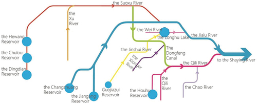
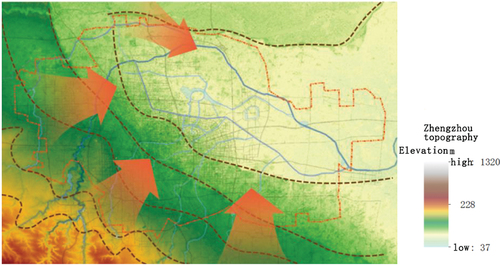
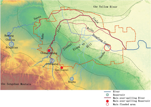
The central urban area of Zhengzhou is adjacent to the Yellow River in the north and hills in the southwest and west. The overall terrain is inclined from southwest to northeast, and the terrain is transformed from hills to piedmont inclined plain and Yellow River-Huai River alluvial plain. There are the Suoxu River, Jialu River, Jinshui River, Xiong’er River, Qili River, Chaohe River and other rivers in order from northwest to southeast in the urban area (). Most of them originate from the foothills of Songshan Mountain in the southwest of the city. As a whole, it flows through the urban area from the southwest to the northeast, then converges on the main stream of the Jialu River and then flows out of the urban area to the east. The Dongfeng Canal is an artificial channel that receives the Jinshui River and the Xiong’er River from the northwest to the southeast and joins the Jialu River through the Qili River. It can be seen that the Jialu River undertakes almost all the rivers flowing through the urban area (), and most of the surface runoff from the upper mountainous area to the entire central urban area is finally collected by the Jialu River and then exits the city, making it the most important river for urban flood resilience and drainage in Zhengzhou.
Figure 1. Topography and water system in the central urban area of Zhengzhou.
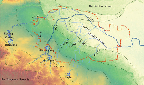
Figure 2. Water system in the central urban area of Zhengzhou.
3.1. Superposition of external floods and internal floods
The rainstorm process on July 17–20, 2021 mainly includes two phases. The first phase is concentrated in the western part of the city starting at 8:00 on the 17th (). The peak rainfall intensity was reached at 13–14 and 15–16 o’clock on the 20th (). Secondary disasters such as mountain floods and mudslides occurred in the western mountainous area of Zhengzhou, causing 251 deaths and missing, accounting for 66.1% of the total (WU and WAN Citation2022). The upstream Changzhuang Reservoir began to discharge floodwater into the tunnel and spillway after it exceeded the warning level and was threatened by piping. In addition, the influx from the higher-lying areas in the west is also one of the sources of floods in Zhengzhou (CUI et al. Citation2023). The second phase was from 16:00 to 17:00 on the 20th. The central urban area of Zhengzhou experienced an extreme rainfall of 201.9 mm/h (), resulting in a huge amount of surface runoff, which not only exceeded the drainage capacity of the municipal pipeline network but also flowed into the urban rivers and caused overflows. Overflows of river channels superimposed with rainfall in urban areas aggravate the flood in urban areas.
Figure 3. Actual rainfall in Henan on July 20th.
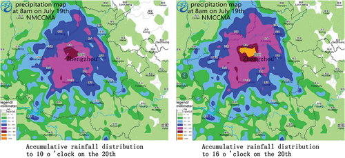
Figure 4. Rainfall changes in various regions of Zhengzhou from July 18th to 20th (Wang Citation2021).
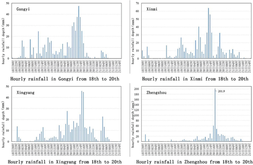
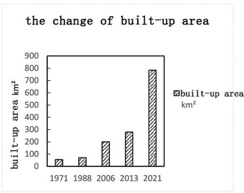
Figure 5. Area change process of central built-up area.
3.2. Urbanization and surface impermeability
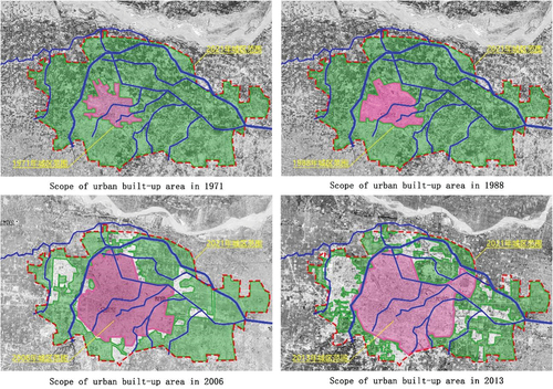
Based on the analysis of satellite maps, in the 50 years from 1971 to 2021, the built-up area of Zhengzhou city centre increased from 54.65 km2 to 784 km2 (), an increase of 14 times. Rapid urbanization has resulted in dramatic changes in the type and permeability of urban underlying surfaces. Compared with 1971, in the built-up area of the city centre in 2021, more than 90% of the farmland and natural vegetation in the original outer periphery transformed to impervious surfaces due to urban construction (), and the surface runoff coefficient will increase from 0.2–0.45 to more than 0.8 (Yang Citation2013), which will inevitably lead to a decrease in the infiltration of rainfall of the same magnitude and an increase in the confluence; in the urban river channels that undertake the municipal drainage network, the Jialu River and Qili River, which were originally outside the city, have become river channels in the urban area (). Although the overall pattern of the main river channels changed little, after the river catchment units transformed to impervious surfaces, under the same magnitude of rainfall, the surface runoff increased, the runoff time was shortened, the runoff peak was advanced, the burden of the municipal drainage network increased, and the flow into the river increased significantly. Without increasing the number of rivers and the density of the river network, it will greatly increase the drainage burden of urban rivers, which is not conducive to the discharge of urban floods.
Figure 6. Change process of proportion of urban land types (based on 2021 urban area).
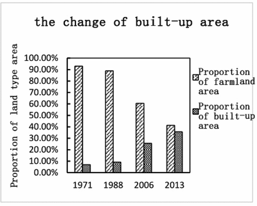
Figure 7. Land type changes from 1971 to 2013 within the built-up area in 2021.
3.3. Drainage and storage of urban water systems
Water spaces such as rivers, lakes, and reservoirs in the urban water system are the ultimate recipients of rainwater and play an important role in the drainage and storage of rainwater.
3.3.1. Upstream reservoirs
Reservoirs are mostly built in the upper reaches of the river, which can store floods, reduce the peak flow of floods entering the downstream rivers, and play the role of flood control and flood reduction. There are many reservoirs in the upper reaches of the Suoxu River, the Jialu River and the Qili in Zhengzhou city. Among them, the Hewang Reservoir, the Chulou Reservoir and the Dingdian Reservoir are built on the Suoxu River, the Jiangang Reservoir and the Changzhuang Reservoir are built on the Jialu River, and the Houhu Reservoir was built on the Qili River. (), the flood control standard of these reservoirs is once-in-a-century, and it is the first barrier to block rainwater in the southwestern mountainous area of the city (Compilation Committee of Zhengzhou Water Affairs Records Citation2014).
Figure 8. Reservoir capacity of upper reaches of the Jialu River.
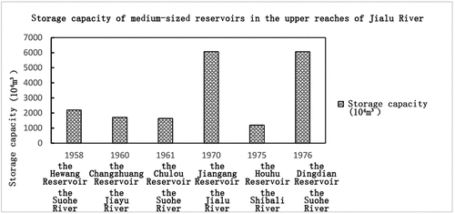
Data source: Compilation Committee of “Zhengzhou Water Affairs Chronicle”. Zhengzhou Water Affairs Chronicle [M]. Zhengzhou: Yellow River Water Conservancy Press. 2014.
According to government reports, the rainstorm caused 103 of the 143 reservoirs in Zhengzhou to exceed the flood control level (Information Office, the People’s Government of Henan Province Citation2021), and some even exceeded the highest level in history. The Changzhuang Reservoir in the upper reaches of the Jialu River exceeded the warning level at 10 am on the 20th and began to discharge floods. The Guojiazui Reservoir in the upper reaches of the Jinshui River had signs of flooding and dam burst at 1:30 a.m. on the 21st (Ministry of Emergency Management of People’s Republic of China Citation2021), while the downstream water level has exceeded the fortification standard, posing a greater threat to the urban areas on both sides of the river. Some reservoirs in this disaster have certain risks and hazards (Han & Zhang Citation2021). Therefore, although the upstream reservoir has the function of flood control, if the maintenance is insufficient, the water level is not adjusted in time during the flood season, and it is prone to danger.
3.3.2. Urban rivers
Urban rivers directly undertake the rainwater discharged from the municipal drainage network, which is not only an important channel for dredging urban floods but also regulates and stores a considerable capacity of rainfall. Among them, “river section” and “river network density” are important indicators for measuring drainage and storage capacity.
3.3.2.1. River section
Increasing the width and depth of the river section is beneficial for reducing the flood flow, increasing the drainage capacity of the river (Ji et al. Citation2008), reducing the flood water level, and easing the jacking of the municipal drainage network.
The Dongfeng Canal was originally an artificial channel for irrigation from the Yellow River. In the “Three Rivers and One Canal” project in 2002, the flood-proofing standard was raised to a once-in-50-year level, along with urban river channels such as the Jinshui River, the Xiong’er River, and the Qili River. After the Dongfeng Canal takes over the Jinshui River and the Xiong’er River to the Qili River, the width of the channel is widened to 60–100 metres (Compilation Committee of Zhengzhou Water Affairs Records Citation2014).
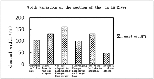
The Jialu River is the confluence of all rivers in the urban area. The upstream slope of the urban section is relatively steep, approximately 3‰, the confluence flow velocity on the slope surface is large, and the upstream water flow is fast; after entering the northern urban area, the slope decreases, and the water flow is relatively gentle (Ewater Citation2021). The main stream flows through the urban area in a “zigzag shape”. The upper part of the tributary of the Suoxu River gathers rainwater from the western mountainous area and joins the Jialu River north of the old airport in the north of the city; the tributary “Dongfeng Canal – Qili River” gathers the Jinshui River, Xiong’er River and Chaohe River and is greatly affected by rainfall inside the city. They flow through the urban area from the northwest to the southeast and join the Jialu River in Baisha Town in the east of the city (). There is a time difference when many tributaries of the Jialu River converge, which has a buffering effect on the convergence of the main stream flow during the flood season. However, if the whole basin has intensity rainfall at the same time, the superposition of the flood discharge from the reservoir and the urban flood will cause the water level to be high. As the only flood discharge outlet in Zhengzhou city, the Jialu River had insufficient flood discharge capacity due to groundwater overexploitation and river siltation before the 1990s. From 2016 to 2021, the comprehensive treatment project of the Jialu River will make the width of the urban section reach 100–160 metres. The fortification standard of most river sections is once-in-50 years, and some are once-in-a-century. However, after leaving the city, the river fortification standard in Zhongmou County is only once every 20 years (Compilation Committee of Zhengzhou Water Affairs Records Citation2014), and the width of the riverbed is 25–30 metres (), so there are inconsistencies in the flood sections of the Jialu River upstream and downstream. During the “7.20” heavy rain event, Fuwai Hospital in the east of the city was submerged because the water level at the confluence of the Wei River and the Jialu River overflowed the embankment.
Figure 9. River structure diagram of central urban area of Zhengzhou.
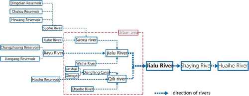
Figure 10. Width variation of the section of the Jia Lu River.
3.3.2.2. River network density
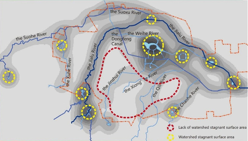
From 1971 to 2021, the urban area expanded, and the original urban peripheral river channels were transformed into urban river channels, basically continuing the pattern of natural water systems. According to GIS analysis, the urban river network density in 2021 will be 0.27 km/km2 (). Although the river network density has increased compared with 1971, the distribution of the river network is not uniform. As shown in , the density of the river network in the Longhu area of Zhengdong New District is the highest, exceeding 1 km/km2, and the density of the river network in the area where the Jinshui River, the Xiong’er River and the Qili River pass in parallel is approximately 0.5 km/km2. However, there are some areas in the urban area where the river network density is less than 0.05 km/km2. If these areas have low-lying areas, unreasonable vertical design of the municipal drainage network, and lack of surface drainage channels (), it is likely to become a hazard of urban floods.
Figure 11. Change process of urban water system density.
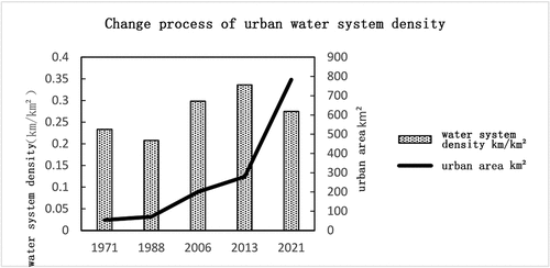
Figure 12. Analysis of urban river network density distribution.
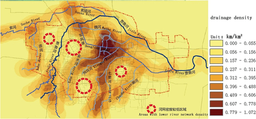
Figure 13. Urban elevation characteristics of Zhengzhou.
3.3.2.3. Facilities set up in the river course
There are numerous bridges, culverts, sluices and dams along the river, but the management of temporary facilities is insufficient in some river courses of urban areas. When the flow increases, the phenomenon of river obstruction and backwater is prominent. The smooth flow of the river channel guarantees its flood control capacity. However, unreasonable cofferdams have been set up at many landscape facilities in the urban section of the Jialu River, which suddenly reduces the flood discharge section of the river; the design of the bridge and culvert sections of some landscape bridges is unreasonable; and several dams are installed along the river to maintain the water level of the river (). Such facilities are distributed in a large number in the urban section of the Jialu River, which is not conducive to river flood discharge ().
Figure 14. River channel changes at bridges and culverts along the Jialu River.
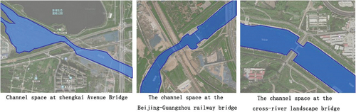
Figure 15. Change of water surface rate in built-up area from 1971 to 2021.
3.3.3. The urban lakes
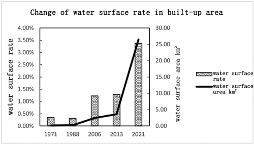
The lakes and low-lying wetlands connected by urban lakes and rivers can adjust and store the incoming water in the basin during the flood season, play the role of storing river floods, reducing floods, detaining floods, and relieving the pressure of regional flood control (Zhu, Zhou, and Ke Citation2014). In the 1970s, the urban centre of Zhengzhou was small, and the water space in the city was dominated by river courses. With the gradual expansion of the city, the water space in the city consists of the river courses and a number of urban lakes on the basis of depressions. In the ecological water system construction project after 2006, ecological lakes such as Longhu Lake, Longzi Lake and Xianghu Lake were newly built in key areas such as Zhengdong New District and High-tech Zone, which not only enhanced the flood control and drainage functions of rivers and lakes but also improved the ecological environment of the city. In 2021, the overall water area of the central area will reach 26.4 km2, and the water surface rate will reach 3.38% (). Longhu Lake in Zhengdong New District is located in a low-lying area of the city, which has retention effects on urban rainwater and relieves the flood discharge pressure on the lower reaches of the Jialu River. Although the increase in the local water area can play a certain role in regulating and storing, the overall uneven distribution of receiving water bodies in the urban area of 784 km2 makes the entire regulation and storage system insufficient. ().
Figure 16. Analysis of water area distribution in the urban district of Zhengzhou.
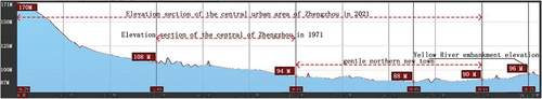
3.4. Influence of natural terrain
Before the 1970s, the central area of Zhengzhou was mainly located in the piedmont inclined plain, the elevation slowly decreased from the southwest to the northeast, and the slope was 0.1%-0.2%, which was conducive to the relief of surface runoff and the layout of the municipal drainage network. In the past 40 years, Zhengzhou City has expanded outwards with the old city as the centre. Among them, most of the new urban areas in the north of the city are located on the alluvial plain between the inclined plain and the embankment of the Yellow River (). Because it was originally a lake and swamp formed by the flooding of the Yellow River, the terrain is gentle and slowly descends to the centre. The elevation of the north and south sides is 6–8 metres higher than that of the central part, and the overall slope is less than 0.1%. Its topography is an unfavourable factor in the layout of the municipal drainage network, which is superimposed with the lower discharge velocity of the downstream river, forming a greater threat of flooding.
Figure 17. Topographic profile of Zhengzhou urban area (north‒south direction).
3.5. Flood risk in underground spaces
Subway, building basement, underpass tunnel, underground parking lots, constructing foundation pit, are located in the lowest part of urban structures, which have a certain embedded depth. As a consequence, underground spaces are at high risk of inundation (Shu, Lu, and Ruan Citation2015).
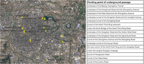
Due to the vulnerability of underground spaces to resist floods, it is not conducive to escape and avoidance during floods, and associated secondary disasters are prone to occur, resulting in loss of life and property. In the “7.20” event, the underground spaces were severely damaged and suffered serious water accumulation, such as the Jingguang Tunnel, the Hongzhuan Road Tunnel, the Weisi Road Tunnel and other underpass tunnels, especially the Wulongkou parking lot of Metro Line 5 (), the First Affiliated Hospital of Zhengzhou University and Fuwai Hospital, which were submerged due to the influx of external floods. The worst of all caused 39 people to drown in the underground space, including 6 people in Beijing-Guangzhou Tunnel and 14 people in Metro Line 5 (Information Office, the People’s Government of Henan Province Citation2021). In addition, the flooding of basements of hospitals, parking lots, shopping malls and other buildings also caused numerous economic losses.
Figure 18. Water accumulation point of Underpass as of July 26(Zhengzhou Municipal People’s government Citation2021).
3.6. 3.6 Summary of flood causes
The main reason for the 7.20 flood in Zhengzhou was that the intensity and scope of the extreme rainstorm far exceeded the urban flood control and drainage fortification capabilities. According to the “Comprehensive Plan for Drainage (Rainwater) and Waterlogging Prevention of Zhengzhou Metropolitan Area (2015–2030)”, Zhengzhou’s drainage system will reach the once-in-50-year (199 mm in 24 hours) standard by 2030. Even if it reaches this standard, it will not be able to meet the requirement that the drainage system discharges 624.1 mm of rainfall in one day on July 20. The full load river channels in the city also made the drainage network unable to discharge the urban rainfall normally, resulting in severe floods in the urban areas, more than half (2,067) of the residential underground spaces and important public facilities of the city were flooded, and several areas were cut off from the Internet and power (Disaster Investigation Team of The State Council, 2022).
Under such extreme rainstorm, the overflows of urban rivers and upstream reservoirs aggravated the urban floods. The inconsistency of the cross sections in the upper and lower reaches of the Jialu River hindered the discharge of the floodwater, causing the urban reaches of river to overflow. The Jinshui River, Weihe River, Chaohe River, Qili River, and other rivers also overflowed due to multiple bayonets, which aggravated the waterlogging in some urban areas (Wang et al. Citation2022). The danger of the pipe risks of the Changzhuang Reservoir which on the upper reaches of the Jialu River threatened the safety of the South-to-North Water Diversion Project and the Beijing-Guangzhou Railway downstream. The danger of overtopping in the Guojiazui Reservoir on the upper reaches of the Jinshui River forced 98,000 people to evacuate ().
Figure 19. Main over-spilling rivers and reservoirs.
4. Treatment and response to rainstorms and floods
4.1. Construct the overall flood prevention strategy of the river basin dominated by the urban water system
4.1.1. The urban water system is the main body of urban flood management
The most important historical experience in preventing floods in ancient China is to build a comprehensive urban water system. When building the city, it focused on dealing with the dialectical relationship of “sufficient water to use and protection from ditches” and constructed a water system planning pattern of “surrounding the city, rivers and canals running through the city, and ponds and lakes scattered”. An empirical quantitative balance is established between the size of the city and the drainage and storage capacity of the water system. The “integrated drainage and storage” function of various water bodies in the city and its rational layout at the level of urban planning are crucial to preventing floods (Wu et al. Citation2014).
Looking at the past and the present, China has experienced rapid urbanization, and the scale of the city has undergone tremendous changes. Compared with the ancient city, the municipal drainage network has replaced some rivers, canals, lakes and ponds in the city, and the large area of impervious surface blocks the infiltration of rainwater, which increases the drainage load of the drainage network. However, the river network is still the final recipient of urban rainwater, and a reasonable urban water system layout and scientific planning on important indicators such as river network density, water surface rate, and river section are the keys to controlling urban floods.
4.1.2. Scientific and rational planning of the urban water system
The scientific and rational layout of the urban water system requires the close cooperation of urban planning, geography, hydrology, water conservancy, municipal administration, ecology and other disciplines. The major of geography provides a theoretical basis for the evolution of the water system and the urbanization of the watershed and puts forwards the indicators of the water system. The major water conservancy focuses on the hydrological process of rivers and flood control and drought relief. Based on multidimensional comprehensive research on urban functional groups, traffic, vertical systems, and landscapes, the urban planning major has formulated the basic framework of urban water systems, making water systems a natural carrier for the urban ecological environment and space beautification. The municipal drainage major focuses on the division of drainage regions and the planning of pipe network systems in built-up areas.
4.1.3. Restoration of the near-natural form of the urban water system
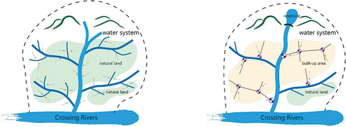
The urban water system is based on the transformation of the natural water system. The end tributaries in the urban area gradually disappear and landfill in the urban construction, resulting in a reduction in the development coefficient of the river network and forming the morphological characteristics of “strong stems and weak branches” in the urban water system. Compared with the morphological characteristics of the natural water system (closely integrated with the terrain; complete primary, secondary and tertiary tributaries; strong ground water permeability in the basin), the tertiary tributaries of the modern urban water system are mostly replaced by the municipal drainage network. The large area of impervious surfaces allows rainwater runoff to converge in a short time and directly drain into the main stream channel through the drainage network (Song et al. Citation2018) (). Affected by urban construction, the morphological characteristics of the urban water system have lost the dynamic balance between the natural water system and the original environment and lack the natural flexible space for rainwater drainage and storage, therefore becoming one of the causes of urban floods. As a result, repairing and reconstructing the near-natural water network system of the urban water system, enhancing the overall connectivity of the water network, changing the state of the one-way confluence of river channels, and improving the runoff transfer efficiency of urban water systems and the capacity of drainage and storage in the whole basin are inevitable ways to deal with urban flood disasters.
Figure 20. Changes of water system morphology in the process of urbanization in the basin.
4.1.4. Improve the river network density and water surface rate of the urban water system
In the process of urbanization, since the municipal drainage network replaces the terminal tributaries of the water system, the water surface rate and river network density per unit area will inevitably decline. The municipal drainage network has become the medium connecting the catchment unit and the confluence channel. The natural balance between the area of the catchment unit in the original environment and the tributaries at the end of the water system is replaced by the empirical calculation between the catchment unit and the confluence channel dominated by the municipal drainage network. When extreme rainfall occurs, runoff exceeds the drainage and storage capacity of pipe networks and river channels, resulting in flooding. River network density is a key indicator that affects the vertical division of water catchment units and the efficiency of surface runoff storage (Liu Citation2017). Increasing the river network density and water surface rate and changing the uneven distribution of regional river channels can increase the integration between the water system and the vertical direction of the city. It can also reduce the area of the catchment unit and the drainage load of the municipal drainage network, provide sufficient drainage channels and storage space for surface runoff, make the drainage facilities flexible, and provide a strong guarantee for the prevention and control of floods.
4.1.5. Guarantee the smooth flow and discharge of urban rivers
The smooth flow and discharge of rivers is significant for the prevention and control of urban floods. To ensure the smooth flow of the river, it is necessary to formulate rigorous measures in the upstream and downstream river sections, the gradient of the river, and the blue and green lines on both sides of the river.
River section is a key indicator that affects the flood flow and storage capacity of the river (Wu Citation2012. Based on the confluence characteristics of the main and tributaries of urban river courses, at the river basin level, the river sections of the upper, middle and lower reaches must be set in an orderly and reasonable manner according to the confluence water volume. Additionally, a suitable width-to-depth ratio of the river section can reduce the sedimentation of the river channel and the disturbance of the water flow, reduce the irregular scouring of the river bank, and improve the stability of the river discharge.
The safety of the river channel must also expand the elastic space on the basis of ensuring the flood discharge section, reasonably delimit the blue and green lines on both sides of the river, reserve buffer space for excessive floods, and serve as a carrier of urban water system ecological governance and functional diversification.
The river gradient is an important factor affecting the fluidity of the water body and discharge velocity. A reasonable river gradient can prevent the river channel from silting, reduce the scouring of the embankment, ensure smooth discharge, and establish a balance between the water flow speed and the scour strength of the embankment (Wang Citation2021). In urban rivers, a sluice-pump joint control system can be set up to improve the hydrodynamics of the river and control the orderly discharge and storage of the river (Zhang and Luo Citation2019).
4.2. Construction of the “large sponge system” in the basin
The urban water system belongs to the natural river basin and is a part of the basin hydrological system. Transit floods (external floods) are also the main cause of urban waterlogging. “External floods and internal waterlogging” and “flood and waterlogging from the same source” make urban floods and waterlogging coexist. Therefore, urban flood control must establish a holistic view of the watershed, taking the watershed as a complete water catchment unit, while the city is a subunit of the watershed (Chen et al. Citation2021). A multidimensional sponge system is built on the spatial scale of the river basin, region, city and area.
4.3. Establishment of the disaster prevention concept of the “resilient city”
The uncertainty of extreme rainstorms makes it possible for flood disasters to exceed the fortification standards and accommodating capacity of existing facilities and systems. The redundancy of blindly improving fortification standards has instead become the source of urban vulnerability. Once the facilities collapse, the damage to the city will be unpredictable (Qiu Citation2021). Therefore, the city’s flood prevention and control measures are required to change from “rigid disaster prevention” to “flexible disaster prevention” and from “engineering fortification” to “coexistence with floods”, which is a comprehensive risk management transition (Li et al. Citation2021). Therefore, cities need to supplement green and distributed “resilience”. On the basis of resisting disasters, by actively adapting to risks, absorbing losses and ensuring that the urban system can recover quickly from disasters, cities ultimately become “resilient” to deal with floods.
4.4. Improving the urban flood emergency management system
4.4.1. Risk assessment system
The extreme climate makes the city face uncertain flood risks, and it is urgent to assess the degree of damage caused by flood disasters to the city and to formulate adequate plans for disaster response, including disaster prevention facilities assessment, compilation Flood risk map and establishment of disaster response management system (Bai Citation2018).
The flood risk map reflects the degree of disaster when cities face flood disasters of different intensities. In high-risk areas, the construction of factories, enterprises and residences must be restricted, and flood passages and water bodies must be protected (Wang et al. Citation2013); in other risk-related areas, people should be guided to participate in disaster prevention and hedging.
4.4.2. Urban flood warning system
Flood disaster warning is one of the core contents of disaster prevention emergency plans, and its purpose is to achieve “real-time monitoring – accurate warning – emergency response”. For administrators, disaster warning facilitates the sharing of warning information at all levels and departments and is conducive to timely initiation of the corresponding emergency response. The public can receive accurate and warning information in time, exact risk scope and guidance on the nearest emergency shelters through communication tools to avoid risk on their own. To achieve the purpose of timely response after warning, we are supposed to establish a stable warning release mechanism and carry out daily risk avoidance publicity to the public in terms of media. According to the flood risk map, we should set up monitoring equipment in urban flood-prone areas and establish a flood monitoring and warning platform. Especially in flood-prone areas, warning facilities should be set up to provide the public with guidelines for avoiding flood risk.
4.4.3. Emergency rescue system
When extreme weather brings flood disasters, the management department must organize rescue to ensure the safety of people’s lives. The forces for on-site rescue include not only government functional departments, public security, and armed police but also civil rescue organizations and spontaneous mass rescue. Therefore, a preestablished emergency command system should be coordinated (Li Citation2019). After starting the emergency response, according to the plan, first, the flood prevention facilities are adjusted, and the public is organized for transfer. During the disaster, we were supposed to rescue the “lifeline” facilities, organize rescue and treatment, coordinate the risk avoidance facilities, and deploy rescue equipment and supplies. During the postdisaster period, we should offer relief to victims of disaster and reconstruction (Zhang Citation2009).
4.5. Event Enlightenment
Located in inland China, Zhengzhou belongs to the typical temperate monsoon climate in Asia, with rainfall concentrated in summer. It is located at the junction of the southwest mountain and plain. Meanwhile, its urban area is mainly distributed in the plain, which is not conducive to the relief of floods. Under conditions of extreme weather, the flood risk of large plain cities with concentrated populations and high urbanization is high. Many cities in the North China Plain are similar to Zhengzhou. Most of East Asia is located in temperate monsoon and subtropical monsoon climate zones, which are greatly affected by monsoons and typhoons. Moreover, the topography and water system development have certain similarities, and cities generally adopt high-density and high-concentration layouts. Therefore, the measures for flood prevention and control in Zhengzhou can be applied to cities with similar climatic conditions, landforms, and urban characteristics in China’s monsoon areas, East Asia, and even the southeast of the United States.
In the process of urban planning, due to the high demand of high-density cities for river drainage, we should take the river basin as the overall planning of river flood control standards and upstream and downstream flood sections, and the terminal tributaries and lakes that have disappeared in the process of rapid urbanization should be restored to provide urban water systems ecological space. In terms of urban management, due to the influence of urban topography and layout, there are different degrees of disaster areas, so it is urgent to enhance the awareness of emergency flood control. At the same time, city managers should improve the maps of flood risk, formulate emergency plans and rescue systems in advance and implement them in villages and towns, pay attention to disaster prevention measures for special population, all of which can reduce the impact of floods. As for construction engineering, measures such as permeable materials and greening are adopted to slow down the hardening of the underlying surface in urban construction, and building elevation and construction specifications should be strictly controlled.
5. Conclusion
The urban construction of Zhengzhou has experienced rapid development, and dramatic changes have taken place in the natural and artificial environment of the city. In the event, the superposition of the flood discharge from the upstream reservoir and the numerous amounts of surface runoff generated by the impervious surface in the urban area increased the load of the river channel. As the only outlet of the urban river channel, the inconsistent layout of the main river and tributaries of the Jialu River and the incongruity of the river section restrict its flood carrying capacity, and even worse, the unreasonable flow blocking facilities in the river channel exacerbate this phenomenon. The density of river channels and the distribution of water spaces in the entire urban area also do not match the drainage of the city. The gentle terrain makes the drainage of river channels and the efficiency of the drainage network insufficient. For the above reasons, the roads, underground spaces and underlying buildings in the urban area were flooded.
Based on the causes of floods in Zhengzhou’s urban area on July 20th, it is proposed that the urban water system dominated the overall flood prevention of the watershed, the construction of a watershed-level sponge system, the concept of resilient disaster prevention guiding ideology of urban construction, and the establishment of an institutionalized urban flood emergency system. The urban water system is the main body of urban flood management, and it must be rationally planned by integrating multiple disciplines. It is an effective way to improve the ability of urban flood prevention to control its planning form, such as indicators such as river network density, water surface rate, river section, and river gradient, to connect it with the drainage facilities in the upper, middle and lower reaches. The whole basin will build a “sponge city” rainwater management facility in a coordinated way, and it will become an organic whole for system coordination. The institutionalized flood emergency system is the basic safety guarantee when dealing with extreme rainfall disasters, which can be used for providing the action basis of disaster risk estimation, real-time monitoring, risk avoidance, disaster and postdisaster relief. The ultimate goal of the above measures is to enable cities to have the resilience to resist, absorb and quickly recover from severe floods and gradually improve the urban flood prevention system.
Disclosure statement
No potential conflict of interest was reported by the authors.
Additional information
Funding
Notes on contributors
Yan Li
Yan Li (1979-), male, Ph.D., senior engineer of the State Key Laboratory of Subtropical Building Science, School of Architecture, South China University of Technology, and Architectural Design and Research Institute of South China University of Technology.
Shishang Ye
Shishang Ye (1995-), male, master student, School of Architecture, South China University of Technology.
Qingzhou Wu
Qingzhou Wu (1945-), male, Ph.D., professor of the School of Architecture, South China University of Technology, doctoral supervisor, member of the Academic Committee of the State Key Laboratory of Subtropical Architecture Science, Director of Architectural History and Culture Research Centre, South China University of Technology, Planning of a Famous Historical and Cultural City of China Urban Planning Society Member of the academic committee. Corresponding author of this article.
Yunjiang Wu
Yunjiang Wu (1975-), male, Ph.D., associate professor at the School of Water Conservancy and Civil Engineering, South China Agricultural University.
Shihui Qian
Shihui Qian (1999-), female, master student, School of Architecture, South China University of Technology.
Notes
1 The United Nations Intergovernmental Panel on Climate Change (IPCC) pointed out in its fifth report in 2013 that global warming has affected the frequency, intensity and duration of extreme climate events. From 1880 to 2012, the global average surface temperature increased by 0.85 °C, especially in the past half century, and the heating rate was approximately twice that since 1880. Climate change promotes more intense and frequent atmospheric activities and changes the climate pattern in continental regions, and extreme rainfall events are frequent and intensified. The rainfall in China is concentrated in summer and autumn, and most cities face the threat of heavy rainfall during the flood season.
2 The 2015 National Assessment Report on China’s Extreme Weather and Climate Events and Disaster Risk Management and Adaptation pointed out that China’s extreme weather and climate events have many types, high frequency, obvious periodicity and seasonality, large regional differences, and a wide range of impacts. In the past 60 years, there have been significant changes in extreme weather and climate events in China, among which local heavy rainfall and urban floods have increased significantly..
3 As of 12:00 on August 2, the press conference of the Information Office of the Henan Provincial Government reported that a total of 150 counties (cities, districts), 1,663 townships and 14.5316 million people were affected by the disaster, with a direct economic loss of 114.269 billion yuan. The catastrophic flood caused a total of 302 deaths and 50 missing deaths.
4 The 2020 China Statistical Yearbook shows that by 2019, China’s urbanization rate was 60.6%, and the urban built-up area was 60,300 square kilometres, approximately 1.5 times that of 2010, 3 times that of 2000, and 5 times that of 1990.
5 According to the Global Times official account on July 20, the water level of the Changzhuang Reservoir reached 127.87 metres at 10:57 a.m. on July 20 (the warning line was 127.49 metres), 38 centimetres above the warning line. Flood discharge started according to the instructions of the provincial and municipal flood control headquarters.
References
- Ewater. 2021. Urban Flood Risk Management from Flood Model Deduction in Zhengzhou [ EB/OL]. https://mp.weixin.qq.com/s/uZxdKPLeD18J889koBm-hA
- Bai, Y. 2018. Risk Prevention and Control of Water Security in Urban Areas[m]. Shanghai: Tongji University Press.
- Chen, J. 2022. “Risk, Resilient City and Refinement of Urban Governance: Taking Zhengzhou 7.20 Heavy Rain as a Clue.” Practice and Theory of SEZS, no. 02: 73–78. doi:10.19861/j.cnki.tqsjyll.20220414.008.
- Chen, Z., and F. Kong. 2022. “Study on Fragmentation of Emergency Management During “7·20” Extreme Rainstorm Flood Disaster in Zhengzhou of Henan Province and Relevant Comprehensive Treatment.” Water Resources and Hydropower Engineering 53 (8): 1–18. doi:10.13928/j.cnki.wrahe.2022.08.001.
- Chen, W., Z. Xu, L. Song, D. Zhang, and P. Liu. 2021. “Research on the Control Measures of Pluvial and Fluvial Urban Floods Based on Holistic View of Watershed System.“ Journal of Hydraulic Engineering 52 (06): 659–672.
- Chen, W., F. Yang, L. Song, D. Zhang, P. Liu, and G. Chen. 2021.Countermeasures for Rainstorm and Flood Prevention in High-Density Cities———the “7·20” Heavy Rain Revelation in Zhengzhou. China Water Resources(15)18–20+23.
- Compilation Committee of Zhengzhou Water Affairs Records. 2014. Zhengzhou Water Affairs Records [M]. Zhengzhou: The Yellow River Water Conservancy Press.
- CUI, H., R. LI, Y. GAO, LI, N., Wang, S. 2023. “Study on the Precipitation Details and Disaster Formation Process Of“7·20”extreme Rainstorm in Zhengzhou.” Journal of Catastrophology 38 (2): 1–10.
- Guo, P., W. Geng, and C. Zhang. 2022. “Remote-Sensing Monitoring of the July 2021 Flood Disaster in Zhengzhou and Northern Henan Province Based on SAR Data of GF-3 Satellite.” Meteorological and Environmental Sciences 45 (2): 86–92. doi:10.16765/j.cnki.1673-7148.2022.02.009.
- Guo, Y. L., H. Wang, and Y. Hu. 2022. “Research on Early Warning of Urban Waterlogging in Zhengzhou City Coupled with Meteorological and Hydrological Models.” Journal of China Hydrology. doi:10.19797/j.cnki.1000-0852.20220030.
- Han, Y., and J. Zhang: With Global Warming and Urbanization, Urban Floods are Becoming More and More Prominent. [EB/OL]. http://news.sciencenet.cn/htmlnews/2021/7/461792.shtml,2021-07-22.
- He, Y., Z. Qi, Y. Feng, and Q. He 2021. Flood Disaster Monitoring Based on Gaofen-3 Radar Remote Sensing Image——taking Zhengzhou “July 20” Heavy Rain Disaster as an Example. The Chinese Hydraulic Engineering Society. (eds.) Proceedings of 2021 Annual Conference of Chinese Hydraulic Engineering Society (pp.333–340). The Yellow River Water Conservancy Press.
- Huang, J., and X. Guo. 2022. “Research on the Adaptation Mechanism of Disaster Response Organization Networks Driven by Emergency Tasks——taking the Response to the “7.20” Heavy Rain in Zhengzhou, Henan as an Example.” Journal of Public Management. doi:10.16149/j.cnki.23-1523.20220511.002.
- Information Office, the People’s Government of Henan Province. The Tenth Press Conference on Flood Control and Disaster Relief in Henan Province [EB/OL]. 2021 08 02 http://www.henan.gov.cn/2021/08-02/2194036.html.
- Ji, H., J. Qiu, B. Huang, M. Lin, and J. Du. 2008. “Experimental Research on Resistance Effect of Long-Channel Pier Group and the Remedial Measures.” Guangdong Water Resources and Hydropower 9: 10–12,15.
- Li, N. 2019. “Analysis and Rescue Countermeasure of Flooding Disaster Accident in Megacity.” Fire Protection Today 4 (9): 3–5.
- Liu, S., Editor-in-C. F. Jiang, Y. Deng and Y. Du Vice-Editor-in-Chief. 2017. Editor. China Flood and Drought Disaster Prevention Strategy, Theory and Practice, Prevention and Control of Flood Disaster, Volume 5 [M]. Beijing: China Society Press.
- Liu, F., W. Qiu, and W. Li. 2022. “Research on the Path of Urban Waterlogging Control Based on Resilience Governance Theory: Taking Zhengzhou’s “7.20” Heavy Rain Disaster as an Example.” Western China 31 (02): 47–56.
- Li, H., B. Wang, G. Meng, and Y. Xiang. 2021. “Ecological Restoration as a Long-Term Solution to Urban Flooding.” Shanghai Urban Management 30 (2): 87–96.
- Ministry of Emergency Management of People’s Republic of China. The National Flood Control and Drought Relief Headquarters of People’s Republic of China Will Upgrade the Flood Control Level III Emergency Response to Level II, and the National Prevention Office and Emergency Management Department Will Dispatch and Guide the Dangerous Situation Disposal of Guojiazui Reservoir in Zhengzhou [EB/OL]. 2021 07 21 . https://www.mem.gov.cn/xw/bndt/202107/t20210721392454.shtml
- Qiu, B. 2021. “Ten Steps Towards Resilient Cities.” China Ancient City 35 (1): 1–8.
- Ren, H., and H. Zhang. 2022. “Characteristics and Main Causes of the 20 July 2021 Flood-Causing Torrential Rain Event in Zhengzhou.“Journal of Hohai University(natural Sciences). 1–14. [2022 08 19]. https://kns.cnki.net/kcms/detail/32.1117.tv.20220316.1645.004.html
- Shu, Y., S. Lu, and Y. Ruan. 2015. Urban Underground Space Planning and Design [M]. Shanghai: Tongji University Press.
- Song, Y., Y. Zhou, and B. Mao. 2018. “Analysis on Changsha City’ S Flood Disaster in 2017.” Journal of Institute of Disaster Prevention 20 (2): 71–77.
- Su, A., X. Lv, L. Cui, Li Z, Xi L, Li H. 2021. “Prediction and Test of Optimal Integrated Precipitation Based on Similar Spatial Distribution of Precipitation.” Torrential Rain and Disasters 40 (5): 445–454.
- Wang, M. 2021. “Discussion on Urban Flood Phenomenon and Treatment Suggestions from the Watershed and Multi-Spatial Scales.” Yangtze River Technical Economy Technology and Economy of Changjiang 5 (3): 8–11.
- Wang, Z., X. Song, X. He, and S. Li. 2022. “Investigation and Analysis of the Dangerous Situation of River Embankment in Torrential Rainstorm of July 20,2021 in Zhengzhou.” Yellow River 44 (7): 44–47.
- Wang, S., Y. Wang, and S. Wang 2013. Science, Technology and Progress of Hydrology and Water Resources[m]. Nanjing: Southeast University Press.
- Wang, Z., C. Yao, J. Dong, and H. Yang. 2022. “Precipitation Characteristic and Urban Flooding Influence of “7 · 20”extreme Rainstorm in Zhengzhou.” Journal of Hohai University(natural Sciences) 50 (3): 17–22.
- Wu, Q. 2012. “Enlightenment from Ancient Experience Against Urban Flood After Rainstorm.” Journal of Catastrophology 27 (3): 111–115,121.
- Wu, Q., Y. Li, Y. Wu, and X. Liu. 2014. “Highlighting Characteristic Urban Canal System and Preventing Flood by Drainage and Storge Systems: Learning from Historical Experience and Proposing Countermeasures Against Flood for MODERN CITIES.” City Planning Review 8: 71–77.
- WU, Z., and H. WAN. (2022). “A Brief Analysis of “7·20” Extreme Rainstormdisaster of Four Cities in Mountainous Area of Zhengzhou in Henan Province in 2021.China Flood &.” Drought Management 32 (3): 27–31. (in Chinese). doi:10.16867/j.issn.1673-9264.2022051.
- Xu, W., C. Liu, J. Lyu, F. Chai, and W. Qu. 2022. Characteristics of “7 · 20” Extreme Rainstorm and Flood-Waterlogging and Countermeasures of the Main Urban Area of Zhengzhou City(05) 5–10. doi:10.16867/j.issn.1673-9264.2022140.
- Yang, D. 2013. “Thoughts on Enhancing the Ability of Cities and Towns to Withstand Flood Disasters.” China Flood & Drought Management 23 (2): 7–8.
- Yao, Y., W. Qu, F. Chai, J. Lyu, C. Liu, and W. Xu. 2022. “Simulation and Analysis of “7 · 20” Extreme Rainstorm Flood in Zhengzhou City.” China Flood & DroughtManagement, no. 05: 1–4+10. doi:10.16867/j.issn.1673-9264.2022156.
- Yu, H., X. Chen, C. Liu, J. Mu, and F. Chai. 2022. “Retrospective Simulation and Analysis On“7·20”extreme Rainstorm and Flood in Central Urban Area of Zhengzhou City.” China Flood & Drought Management, no. 05: 11–15. doi:10.16867/j.issn.1673-9264.2022145.
- Zhang, Y. 2009. Emergency System for Reservoir Flood Control and Theory and Practice of Flood Forecasting[m]. Zhengzhou: The Yellow River Water Conservancy Press.2009.
- Zhang, Q., and W. Luo. 2019. “Discussion on the Influence of River Network on the Prevention and Control of Urban Flood.” China Flood & Drought Management 29 (11): 58–61.
- Zhengzhou Municipal People’s Government. 2021. There are 29 Ponding Points and 105 Collapses in Zhengzhou’s Urban District. [EB/OL].
- Zhong, Y., and Q. X. Meng. 2022. Simulation Analysis of Urban Storm Flood Based on GIS: Taking the “7•20” Torrential Rain in Shifo Town, Zhengzhou City as an Example.China Rural Water and Hydropower: 1-11[2022-08-19]. http://kns.cnki.net/kcms/detail/42.1419.TV.20220218.1744.014.html
- Zhu, Z., M. Zhou, and H. Ke. 2014. Investigation, Protection and Utilization of Lake Resources and Environment in Hubei Province [M]. Wuhan: Changjiang Press.