
ABSTRACT
In this paper, Macau Taipa Village, a historical district in an island-type city, is the research focus, and a parametric design-based method for designing historical districts is proposed. First, the shape and distribution of roads in historical districts is studied through on-the-spot investigation and measurement and data are collected on the width, depth, and area of street blocks, average street length and width, street orientation, building width, depth, acreage, and height, and building orientation. Second, the acquired data are transmitted to the Grasshopper parameterization platform, and an intelligently generated program produces calculations. Through multiple iterations and evaluations of genetic algorithms based on the needs of modern urban design and planning constraints, the building density is further reduced, and more landscape areas are added. The parametric model is optimized to gradually generate the urban spatial design that meets contemporary requirements. The research reveals that (1) the grasshopper algorithm’s generated block design inherits the characteristics of the conventional historical block. (2) The historical block where the data were collected on site and the block where Grasshopper is applied should maintain the consistency of the regional context. (3) This method can be applied to the design of new urban areas, and the scope of application can be further adjusted through collaboration and the needs of the owners at a later stage.
1. Introduction
1.1. Research background
China has a vast territory and a long history. Even today, there are numerous historical structures, historical districts, ancient towns, and villages in both urban and rural areas. According to the data of the third national cultural relics census, a total of 766,722 immovable cultural relics have been registered nationwide (Central Government Portal Citation2023). However, many are not in good preservation conditions and urgently need to be rescued and protected. However, in many places, the project to protect and repair real cultural relics has turned into the vigorous construction of “fake antiques”, and the inheritance of culture has become the target of tourism development and cultural real estate development for the purpose of achieving political points. In 2023, China will organize the fourth national cultural relics census. It is expected to require 3 to 4 years to fully grasp the quantity, distribution, characteristics, preservation status, and environmental conditions of immovable cultural relics (People’s Daily Citation2023). In the late 1990s, the Water Town of Zhouzhuang (an ancient town south of the Yangtze River), the Old Town of Lijiang (an ancient town in Yunnan), and other historical towns achieved great success in style protection and tourism development, triggering a nationwide “ancient town craze”. In this process, there are those who actively protect cultural heritage and rationally develop and utilize ancient town resources. However, there are also blind imitators, overexploiters, and builders of duplicates. There are also those areas that have poor conditions for historical resources and consequently develop a large number of “fake antiques” and manmade landscapes for the sake of seizing short-term benefits (urbanization website Citation2023). In the process of urban development, development is inevitable. How will the characteristics of excellent historical districts and cultural landscapes be “inherited” into the design of new cities?
Historic districts are the long-term manifestation of historical culture and a spiritual symbol of the people who live there, keeping a place’s spirit alive. These districts not only personalize the urban texture but also record the historical evolution of the city as a special carrier that is a comprehensive expression of culture and history. At the same time, the historic district is not a space that is made up of different things that stand independently. Instead, it is a part of the overall urban space. Its spatial form and road texture are the focus of planning and design, as are the elements that will inherit its characteristics in modern urban design. On the other hand, one of the most important things to consider when planning and building new urban areas is how to keep the traditional urban texture. Macau is an important city in China, and it is no exception to these considerations of historical preservation.In the “Consultation Text of New Urban Master Planning,” released in 2015 by the Land and Urban Construction Bureau of the Macau Special Administrative Region, the continuity of the urban texture is particularly emphasized. The consultation text mentions the following goal: “Continuing the unique urban texture of the old city, such as the Largo, the Pátio, and the Beco, to form a small-scale characteristic street space” (Consultation Text of New Urban Master Planning Citation2023). Therefore, this study determines urban characteristics through the study of the spatial form and roads of the historical district and then captures them through a parametric method. The past serves the present, combining traditional and excellent design concepts in an advanced and modern way. Finally, these characteristics can be adapted to the current new city design.
1.2. Literature review
1.2.1. Research on the spatial form of historic districts
A “historic district” is a district with many cultural relics and historic sites. It can also be a district that shows the traditional style and local traits of a certain time in history. The Athens Charter, adopted by the Congrès International d’Architecture Moderne (CIAM) in August 1933, stated that “buildings and districts with historical value should be properly preserved and not destroyed” (International Museum of Modern Architecture, Citation2023). China first proposed the concept of historic districts in 1985 (Li Citation2010; Yao and Jiang Citation2020). Therefore, in the last 100 years, scholars have performed much research from the point of view of spatial form to maintain the historic district’s texture and protect its culture in the best way possible. In the past, the traditional district design was made by architects during the field survey, and the development design needed to be completed in combination with social needs or the subjective awareness of the owner (proprietor) of the land rights. At present, there are several common methods used to explore the spatial form of historic districts: the space syntax model and subjective analysis (Ali, Al-Hashimi, and Al-Samman Citation2018; Mansouri and Ujang Citation2017; Önder and Gigi Citation2010; Xu et al. Citation2020; Yu, TSOU, and Long Citation2009), architectural typology analysis (AlSadaty Citation2022; Arghavan et al. Citation2022; Borsi, Porter, and Nottingham Citation2016; Chen and Romice Citation2009; Weng, Wu, and Bao Citation2020), the SD method and the eye-tracking experimental method (Ding et al. Citation2023; Li et al. Citation2021), the GIS spatial analysis method (Kongphunphin and Srivanit Citation2022), and the improved spatial syntax model (sDNA model) (Guo and Cao Citation2021). Regardless of which method is used, their starting point is to better understand the historical district to facilitate subsequent protection and updated design.
1.2.2. The historical context extends to the new urban design
How can the historical context of the old city be extended to the new urban design? Scholars have carried out practical explorations of urban design, for example, by analysing Budapest’s compact and diverse blocks to unify urban planning (Benkõ Citation2011), by using the concept of “super blocks” to develop new cities, and by complementing the texture of Tirana’s historic districts (Naselli Citation2021). Designers have also used shape grammar and block morphological analysis to generate neighbourhoods with Nanjing characteristics (Weng, Wu, and Bao Citation2020), and combined deep reinforcement learning (DRL) and computer vision for the urban design of Shenyang’s industrial zone (Han, Yan, and Liu Citation2021). Some scholars have begun to examine how computer technology or artificial intelligence can help with the design of city blocks. Therefore, this is also a very promising field of exploration at present.
1.2.3. Parametric and urban design
Parametric design is a method of intelligent design that uses parameters to delimit design variables to achieve repeatability and adjustability (Liu et al. Citation2019; Ramnath et al. Citation2021). Even though changing the parameters in parametric design is not technically designing, the solution is defined as a controlled design application through parameter scripts and algorithms. This gives parametric design the flexibility and stability of general design. In recent years, with the popularization of parameterization, research has also been carried out in the field of urban design. For example, for an urban design to be oriented to a certain factor of the physical environment, the corresponding variables can be controlled through parameterization to obtain the optimal solution (De Luca Citation2019; Ding, Lam, and Wong Citation2016; Kim, Choi, and Kim Citation2022; Salem et al. Citation2016; Schnabel, Zhang, and Aydin Citation2017; von Richthofen et al. Citation2018; Yuan and Ng Citation2012). The main goals of these urban design practices are to make outdoor temperatures more comfortable, reduce the direct sun exposure, and maintain a good breezeway. Historic districts belong to the traditional area of urban design, but they are often not formed in an instant but are the result of the historical evolution of the city. In the past, electronic records were not as advanced as they are now, however, now all design elements can be completely preserved with digital tools. There are no specific design parameters for modern architects to reference in these old districts, which also brings certain difficulties to the sustainable design of the historical district. Therefore, the parametric design method can not only improve design efficiency for architects but also extend the characteristics of historical districts to the texture of new urban design.
1.3. Problem statement and objectives
In general, learning the old ways of doing things in historic districts and determining how to use these elements in new urban design is a very complicated research topic. However, scholars have started to perform quantitative research, and the evaluation indicators and updated design models that have come from these projects have also led to new results. Districts with historical features are currently not suitable for blind imitation. However, the split between the skyscrapers designed for the new city and the old city is also a current phenomenon. There is a promising field of exploration in answering how to extend the spatial form and road texture of the old city (historic district) to the design of the new city, combined with artificial intelligence and parametric generative design methods. In this paper, the researchers explored the following questions:
In an island-type city, what are the characteristics of the spatial form and road organization of the historic district?
What are the morphological criteria of the historic urban fabric? How can the collected data of spatial form, road organization, street width, orientation, and the height, depth, and width of buildings be combined into the algorithm?
How does the genetic algorithm assist in the intelligent design of historic districts? What characteristics of historical districts did this algorithm “inherit” during its implementation?
What are the developed workflow’s applications? How can it be applied to urban design?
2. Materials and methods
2.1. Study area: Taipa Village
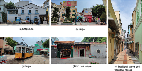
Taipa Village is situated in Taipa’s oldest and best-preserved region (Authentic Macau Citation2023). With its traditional shophouses () and charming cobbled streets, Taipa Village, which was formerly home to local fishermen, offers an antidote to the glitz of the nearby Cotai Strip. This place was originally part of the seaside, and in the past, houses and streets were built according to coastal cities or island-type coastal blocks. Taipa Village is a culturally diverse landmark destination that is richly endowed with a blend of Portuguese and Chinese architecture and unmistakable Mediterranean touches (). Due to the land reclamation in Macau, Taipa, which used to be an outlying island, is now the oldest old town and has become the centre (). It is now surrounded by modern high-rise buildings built on later reclaimed land. At the same time, many historical buildings are preserved in Taipa Village: Vila da Taipa, Tin Hau Temple (), Museum of Taipa and Coloane History, Pak Tai Temple, Carmo Hall, Our Lady of Carmo Church, Sam Po Temple, I Leng Temple, Kun Lam Temple, Feira do Carmo, and a large number of traditional streets and traditional houses ().
Figure 1. Study area: Taipa Village.
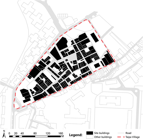
Figure 2. Traditional streets and houses in Taipa Village.
This area mainly consists of 25 streets: Rua do Meio, Rua dos Mercadores, Travessa da Glória, Rua dos Clérigos, Rua dos Bem Casados, Rua de Horta e Sousa, Largo Sanches Miranda, Rua de S. João, Rua do Retiro, Largo Maia de Magalhães, Travessa das Canastras, Rua dos Negociantes, Rua das Virtudes, Rua das Gaivotas, Rua do Cunha, Travessa das Bruxas, Beco das Flores, Rua de Montenegro, Travessa Nova, Rua do Sol, Travessa dos Mercadores, Travessa da Felicidade, Travessa de Santa Gertrudes, Travessa da Esperança, and Rua Ho Lin Vong.
2.2. Analysis of the spatial form and street characteristics of Taipa Village
In Taipa Village, the unique urban texture and spatial form are mainly described as Largo, Pátio, and Beco. In Macau, Largo is the product of the fusion of Chinese and Western cultures. It was introduced by Portuguese colonists as an open space for religious activities in front of churches (Tong Citation2007; Tong and Sheng Citation2005). In Portuguese, it is called “Largo, Praca, Praceta”. After the introduction of “Largo” to Macau, to meet the integration needs of the Chinese and Portuguese people and provide a living environment, the nature of Largos gradually changed from a religious place to a more general place for daily activities (Grzybek et al. Citation2014). Today, many churches in Macau retain Largos in front of them, which are still used for religious activities but can also be used for other public events. From the perspective of history and architectural typology, the traditional “Pátio” and “Beco” in Macau are urbanized, high-density, and relatively closed residential forms derived from the traditional rural residential model. A Pátio is an outdoor space with no roof in a Portuguese house. This small space is combined with the parvis or yard from the Guangdong architectural idiom to form a garden space with Macao characteristics (Ferreira, M., Lima, J., Freire, Ferreira et al. Citation2017). Portuguese “Beco” refers to alleys as types of secondary streets. Unlike in Portugal, this narrow street in Macau is defined as a “connecting place” between neighbourhoods and is used as a narrow walkway between city houses and residences (Xie, Ursini, and Samo Citation2023). Some of the Pátio and Beco are open and connected to the city roads, creating minimal street space. Therefore, it can be understood that in the past, Pátio and Beco were not only an important part of the neighbourhoods scattered around the current Macau World Heritage Historic City but also were part of the unique texture of Macau’s urban development (Zou Citation2020). At the same time, these are also residential spaces that have the traditional settlement and community organization of Macau and reflect the social lifestyle, living culture, and value of the Chinese in Macau in the early days.
2.2.1. Spatial features of Taipa Village
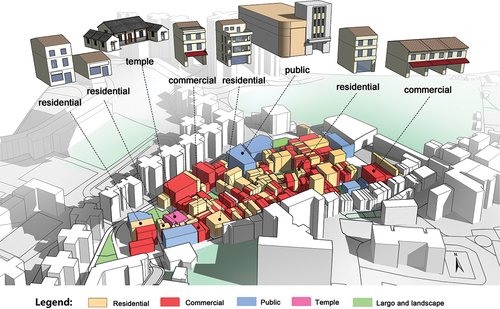
Before the 20th century, Taipa was mainly an island fishing village. After the 1950s, the urban development plan was implemented, and the island’s infrastructure was built, including roads, green spaces, and public spaces. With the rise of industry and commerce, the space in the district has gradually developed from the original residential design to a complex space mixed with commercial and residential buildings. Taipa has a unique style of streets and alleys, forming a neighbourhood with European characteristics and Chinese-Portuguese fusion. Most of the streets, alleys, and buildings in the existing districts retain the spatial form of the early stage of urban development, including original residences, commerce buildings, commercial residences, largos, and public spaces (). It is worth mentioning that although this historic district is called “Taipa Village”, it does not currently have any villages, and it is difficult to find the original trace of the village. For historical reasons, the name has carried over to the present.
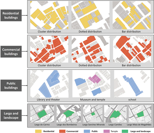
Figure 3. Distribution of residential, commercial, public, temple, largo, and land spaces, and surrounding building areas in Taipa Village.
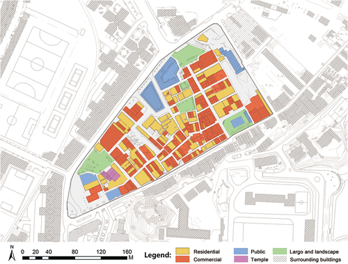
Figure 4. Distribution of building types in Taipa Village.
Today, the most preserved spaces are residential, most of which were built before 1980. Residential buildings over 30 years old are mostly located in the middle of the historic district (Taipa Village), such as Travessa da Esperança, Travessa das Bruxas, and Travessa de Santa Gertrudes. Residential buildings under 30 years old are mainly located at the boundaries of neighbourhoods, such as Rua do Regedor and Rua Correia da Silva. However, due to the long history of the village, the title registration system of half a century ago was not perfect, and the property titles of many buildings still cannot be checked. The buildings with a clear registration status are shown in below. It can be seen from the layout of the residential space that the older residential space is relatively small, and the volume varies. The buildings are usually grouped around a small public activity space, and the street names are dominated by Travessa. The residences that are closer to the present day have larger spaces and regular volumes, and the street names are dominated by Rua. This reflects the relationship between the size of the Taipa Village space and the age of construction. Most of the core areas are small-scale “Travessa” spaces, and the surrounding new residences are dominated by large-scale “Rua”.
Table 1. Statistics on building utilization in Taipa Village.
The commercial space in Taipa Village is transformed from residential space and retains the morphological characteristics of residential space. Commercial spaces are most typical on Rua do Cunha and Rua dos Clérigos. Taipa’s public spaces include the library, museum buildings, and five largos (squares). The public buildings are located on the outer street corners, and the building volume is relatively large. The largo space is located in a relatively dense residential area. As a place for residents to engage in fitness opportunities in their daily lives, the space is mainly enclosed. Among them, Largo do Carmo is located at one end of Rua do Cunha, and at the same time, it has a characteristic pavilion structure combining Chinese and Western styles, providing a place for the crowd to rest and gather. Its east side is a public toilet, and the rectangular square is surrounded by buildings on all sides, which have a high degree of aggregation ().
Figure 5. Group distribution of residential buildings, commercial buildings, public buildings, Largos and landscapes.
2.2.2. Road organization
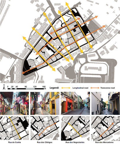
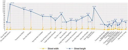
In Taipa Village, the overall road organization generally presents a regular “network structure”. The historic districts are divided into grid-like street blocks by the east‒west and north‒south main streets. The length of the north‒south road is between 43 and 120 metres, and the length of the east‒west street is between 87 and 142 metres. The width of the main street is relatively large, between 3 and 7 metres, and the streets inside the blocks carved by these main streets are relatively small, between 1 and 3 metres. These main road networks have been completely preserved in the process of urban development without major changes. The average road width is 3.76 metres, a very walkable size ().
Figure 6. Analysis of the overall road network structure of Taipa Village.
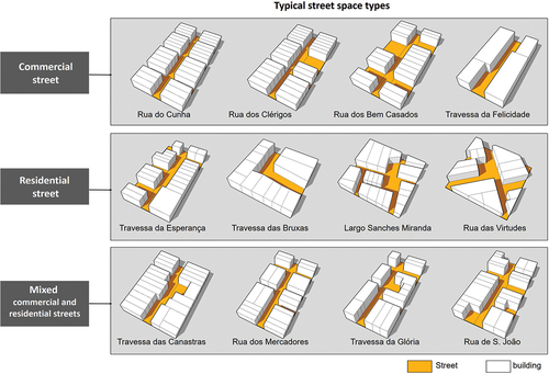
Although the main street network is relatively regular, the roads inside the blocks are more complicated. As the residential function is gradually transformed into a commercial function, increasingly complex functional areas are divided inside the blocks, forming a rich network of internal streets and alley spaces. shows several typical street space types inside the block ().
Commercial streets and alleys. The commercially oriented walkway has a wider street scale, with commercial shops on both sides, and the architectural layout is relatively regular and continuous. (Typical representative example: Rua do Cunha, Rua dos Clérigos, Rua dos Bem Casados, Travessa da Felicidade).
Residential streets and alleys. These are mainly used by pedestrians; with residential buildings on both sides or one side, the building layout is not regular, some spaces are broken, and the volume of single units is uneven. (Typical representative example: Travessa da Esperança, Travessa das Bruxas, Largo Sanches Miranda, Rua das Virtudes).
Commercial and residential mixed streets and alleys. People and nonmotor vehicles are mixed, and residents can enter by motorcycle. The building area is small, the space is scattered and blocky, the space is relatively fragmented, and the volume varies greatly. (Typical representative example: Travessa das Canastras, Rua dos Mercadores, Travessa da Glória, Rua de S. João)
Figure 7. Several typical street space types in Taipa Village.
2.2.3. Taipa spatial data statistics
According to the spatial characteristics of Taipa Village described above, the quantitative statistics of the block space are calculated from the scale of the Taipa Village street, street direction and building orientation, street width and depth, area of the street block, and street-to-lane ratio. A total of 25 streets, 93 street blocks, and 314 buildings were counted (see Appendix B for detailed statistics). The statistical results will be incorporated into the parameterized intelligent generation of the design, thus forming a new space with the characteristics of a historic district (Taipa Village).
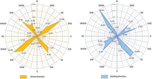
First, the study calculated the statistics of the area by the azimuth. The direction of the streets and the orientation of the buildings present obvious orientation characteristics. The direction of the streets is mainly north by east; 55.41% of the streets are arranged in the direction of 56°, north by east, and 44.59% of the roads are arranged in the direction of 326°, north by west. The streets with a north-to-east direction of 56° accounted for the highest proportion, accounting for 26.12%. The orientation of the building is also very obvious, showing consistency according to the direction of the street. The orientation of buildings is mainly northwest, with 55.41% of the buildings facing northwest at 326° and 44.59% of the buildings facing northeast at 56°. The majority of all buildings face 326°, from north to west, accounting for 14.65% of the total buildings ().
Figure 8. street direction and building orientation analysis in Taipa Village.
Second, the spatial scale of streets was quantified. Taipa Village’s street space includes streets, largos (squares), and landscape spaces, accounting for 25.05% of the total village area. Streets and alleys accounted for 17.49%, and squares and landscape spaces accounted for 7.56%. The street width is between 1 and 7 metres, and the street length varies greatly, ranging from 18.86 to 142 metres. Most of the roads named Rua are longer in length, and the street aspect ratios vary widely. The ones named Travessa are shorter and have a stable street aspect ratio ().
Figure 9. Analysis of street block face width and depth.
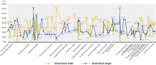
Street blocks are architectural groups formed by dividing the site by streets. There are 93 street block spaces in Taipa village. Street block-scale data affect the generation of historic district space and serve as an important basis for the generation of historic district group space. After counting the length and width of each street block, the acreage of the street blocks is obtained. The street block length ranges from 4.39 to 69.59 metres, and the street block width ranges from 4.40 to 69.59 metres. The values of the length and width of the street blocks are very close, which further proves that the street network in Taipa Village presents a square network structure. The smallest street block has an acreage of only 127.64 square metres, and the largest is 1712.07 square metres. The street blocks with small acreage are dominated by streets named Travessa, and the street blocks with large acreage are dominated by streets named Rua, with large differences in scale. This shows that the volume of buildings inside the square street network varies greatly, and the spatial scale of streets and lanes varies greatly ().
Figure 10. Analysis of street block acreage and depth.
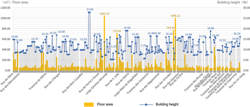
Finally, the architectural scale is quantified. The building scale is related to the shape and feeling of the microspace of the historic district and has an important influence on the parametric generation of subsequent buildings. There are 314 buildings in Taipa Village, accounting for 74.95% of the land acreage. After the scale statistics of all buildings are obtained, it is found that the building width ranges from 2.66 to 41.76 metres (7.6 metres on average), the building depth ranges from 2.90 to 40.01 metres (10.81 metres on average), and the building height ranges from 5.2 to 27.80 metres (11.28 metres on average). The gross floor area ranges from 12.08 to 1043.12 square metres (84.49 square metres on average). The street and alley spaces have a large difference between the building’s face width and depth, showing a tendency for a large face width and small depth. Most other street-facing width scales are approximately 7.6 metres on average. In addition, the gross floor area and building height are also counted. Except for large public buildings, the gross floor areas of commercial and residential buildings are not much different, all of which are 84.49 square metres. There is no uniform rule for comparing the gross floor area and height, which shows that the building scale changes in Taipa Village are very rich (
Figure 11. Building face width and depth analysis.
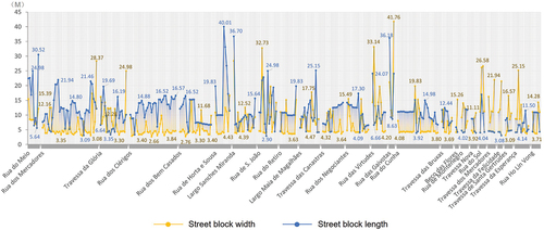
Figure 12. Gross floor area and height analysis.
In summary, through the statistical analysis of Taipa Village by the spatial azimuth, street space scale, and building volume, this study obtained the data characteristics and range values of the spatial changes experienced by the historic district (Taipa Village). These azimuths, length and width scales, heights, areas, and other range data will be included in the parameterized generation of a historic district later in the article as an important basis for influencing the generation of new districts.
2.3. Construction of the parameterized program
This research aims to realize the intelligent generation of the spatial form of the island city’s historic districts and provide scientific and innovative references for urban planning and design. To achieve this goal, this paper proposes a comprehensive approach based on four steps: feature extraction, parametric translation, algorithm optimization, and application ().
Figure 13. Research methods and process.
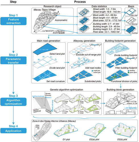
This method aims to use the technology of Grasshopper parametric programming and genetic algorithms to extract key features from existing historic districts, transform them into operable parametric forms, and then generate the best urban spatial form through algorithm optimization (see Appendix A for the operating system conditions for Grasshopper programming of parameterized operations). Through this intelligent generation method, urban design can fully consider the requirements of historical and cultural protection and sustainable development and provide effective solutions for the planning and design of island city historic blocks. The specific content of each step will be described in detail below:
Feature extraction. In the feature extraction stage, this study extracts key spatial features from Taipa Village in Macau. The spatial elements of Taipa Village are composed of three parts: streets, street blocks, and buildings, and detailed data statistics are calculated separately (Appendix B). The street calculations need to include the length and width of different streets to provide guidance for the derivation and generation of subsequent arterial roads and lanes. The street block calculations contain length, width, and area data that are critical for planning the scale and layout of a district. The building calculations include the statistical information of length, width, height, and floor area, and these data have important guiding significance for generating the shape and spatial layout of the buildings. Through the extraction of these key spatial elements, this study was able to obtain accurate data and provide a basis for the intelligent generation process.
Parametric translation. In the parametric translation step, the data obtained from feature extraction will be converted into an actionable parametric form. This translation process includes three key steps: main road generation, alleyway generation, and building footprint generation.
Main road generation. In this step, it is necessary to select the applied plots and carry out basic division according to their contours, areas, and previously counted street block lengths and widths to generate the number and vector directions of arterial roads. Then, according to the statistical street length and orientation data, the curvature of the main road is adjusted to ensure that the generated main road conforms to the actual situation.
Alleyway generation. In the alleyway generation stage, according to the previously divided street blocks, street blocks with inappropriate areas are excluded. Then, according to the statistical street and street block data, alleyway nodes are randomly generated and connected to form an alleyway network. The connection between these nodes is regarded as the generation of lanes; the street blocks are further divided according to the statistical street width, and the street blocks with a suitable area are screened out to prepare for the next step of building footprint generation.
Building footprint generation. At this stage, the main building footprints are divided using the previously generated street blocks and the statistical data of building length, width, area, and orientation. Subsequently, building footprints that meet the range of statistical data are further screened. Depending on the ratio of building to landscape, the amount of area dedicated to a building footprint can be appropriately increased or decreased. Finally, areas for the building footprint and landscape footprint are demarcated. According to the statistical building height and the variance of the height value, district models were generated for these plots to complete the generation work on the entire model.
Algorithm optimization. In the algorithm optimization stage, this study uses a genetic algorithm to generate the best urban spatial form. Considering the high building density in Taipa Village, modern urban design usually needs to reduce building density and increase landscape area to meet planning restrictions and residents’ quality-of-life needs. Therefore, this research will apply a genetic algorithm to improve and optimize the model obtained through parametric translation to gradually generate urban spatial forms that meet the requirements. The genetic algorithm explores and improves the generated urban spatial morphology through multiple iterations and evaluations. In the genetic algorithm, the main control parameters include the length and width of the street block, the length and width of the building footprint, and the minimum area allowed to generate the building. The target parameters relate to the total building base area and landscape area of the plot. Through the genetic algorithm, tens of thousands of control parameter combinations can be calculated, and continuous iteration and optimization are carried out to gradually approach the optimal target parameter combination. For example, one could look for combinations that maximize the total building footprint, maximize the total landscape area, or strike a balance between the two. Through the optimization of a genetic algorithm, this research aims to generate an urban spatial design that not only meets modern planning requirements but also improves the quality of life for residents. The use of genetic algorithms makes the optimization process more intelligent and efficient, thereby obtaining better urban design solutions.
Application. In the application stage, this research will apply the compiled parametric model to the actual planning and design project of Zone A of the New District of Macau (Zona A dos Novos Aterros Urbanos), specifically involving the three plots D1, D2(a), and D2(b). The applicability of this research method to different types of plots is verified by practical experimentation, and the robustness of the model is tested. In the application process, the role of the model needs to be clarified. The parametric model in this study can only provide a reference plan for urban design and cannot completely replace all the work of designers. Therefore, in actual urban design work, the model needs to be improved and deepened according to the actual needs and site conditions. The use of mock-ups should be used as a useful aid in the design process in conjunction with the designer’s creative thinking. At the same time, the importance of cooperation and discussion with relevant stakeholders needs to be emphasized. Through close cooperation with relevant stakeholders, an optimized urban spatial design can be integrated with sustainable development principles to ensure the feasibility and practicality of the results. In practical applications, social, economic, and environmental factors need to be considered comprehensively, fully discussed, and balanced to finally achieve the goal of sustainable development.
Validation Criteria and Robustness: This study uses the results of the degree of conformity to the actual design proposal, collaboration, and discussions with relevant stakeholders. In addition, standards such as the degree of integration with the principles of sustainable development are used to verify the applicability and robustness of the model. Specific indicators include road area ratio, landscape area ratio, and building area ratio. For high-density historic districts, the building-to-land area ratio and road-to-land area ratio often reach 75% and 25%, respectively. For low-density historic districts, the building area ratio and road area ratio will be as low as 40% and 25%, respectively, and the landscape area ratio will be 35%. The design standard is determined according to the needs of the land. Therefore, it is necessary to combine the optimized urban spatial form with the principles of sustainable development through close cooperation with relevant stakeholders to ensure the feasibility and practicality of the generated results.
By applying the parametric model of this study to actual projects, combined with the opinions and suggestions of relevant stakeholders, the actual effect and feasibility of the model can be evaluated, and strong support can be provided for urban planning and design. From the organic combination of the above four steps, this research method can realize the intelligent generation of the spatial design of the historic district of the island city. The comprehensive application of this method can provide scientific and innovative references for urban planning and design while taking into account the requirements of historical and cultural protection and sustainable development.
3. Results
3.1. Grasshopper programming result
Parametric design is a design method based on parameters and rules. By transforming each element and relationship in the design process into the value, range, and relationship of adjustable parameters, a variety of design solutions can be quickly generated to meet design requirements under different needs and conditions. This research uses Grasshopper in Rhino as a parametric design tool. Grasshopper uses modular components and can complete programming operations in a visual way. The designed program is shown in , which is mainly composed of numerical value setting, direction setting, and six-step functions.
Figure 14. Modules and ideas of parametric design.
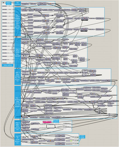
Numerical setting: In this step, the outline of the target plot must be inputted and some basic numerical parameters are set. For example, specific values and ranges such as the length, width, and area of streets, plots, and buildings can also be manually selected by deriving a combination of various values through the genetic algorithm in step 5.
Direction setting: This step aims to meet the needs of different plot shapes and building orientations.
Step 1: In this step, first the edge of the input plot outline is extracted and then divided according to the previously counted street parameters. After the division is completed, the line segment is drawn as the arterial road. Nonquadrilateral plot outlines will be simplified to quadrilaterals to improve computational efficiency and reduce errors.
Step 2: Since the roads in historic districts are often not straight, there will be twists and turns on the main roads. Therefore, in this step, the straight line of the main road is converted into a curve, and the curvature is adjusted according to the previous statistical data.
Step 3: According to the generated district area, several road nodes are randomly generated in this step. The positions of these nodes are determined according to the width of the street block. If the width of the street block meets the requirements of the previously counted street block width range, a node is generated. Finally, these nodes are connected to form the line segments of the alleyway.
Step 4: In this step, values are assigned to the widths of arterial roads and alleyways and the area occupied by these roads is excluded. The remaining street blocks are used as locations for building generation. At the same time, the area of these street blocks is analysed, and the plots that meet the requirements (for example, plots larger than 100 square metres) are reserved for the division of building footprints. The direction of the footprint is parallel to the direction of the road. The remaining plots that cannot be used for building are used for landscaping.
Step 5: In this step, the genetic algorithm is used to derive different schemes. The genetic algorithm uses the Octopus component, connects various values in the value setting to the G port, and inputs the total building base area and landscape area to the O port. Through the derivation of the genetic algorithm, different numerical combinations can be obtained. These numerical combinations will eventually be reflected in the model, as well as in the total building area and landscape area. According to the requirements of different areas, several different schemes can be derived.
Step 6: In this step, a model is built according to the previously derived scheme. The main purpose is to raise the design plane and set the height according to the previously calculated building heights. At the same time, the variance is used to ensure that the building heights are scattered to be consistent with the original conditions in Taipa Village.
In summary, the parametric design provides a flexible, adjustable, and changeable method for the generation of the spatial form of the historic district of the island city. By translating design goals and constraints into specific parameters and rules, designers can explore diverse design options to meet the requirements of historical preservation, residents’ needs, and sustainable development. The application of parametric design ideas makes the design process more flexible and efficient, bringing new possibilities and innovations to the field of urban planning and design.
3.2. Generated process and results
The intelligence-generation process is multistep. It aims to achieve the goal of parametric design by selecting and dividing plots, setting road curvature, generating main roads, setting alleyway parameters, generating alleyways, filtering building plots, dividing building footprints, generating landscape areas, and finally generating models (). In this process, the design goals and constraints are transformed into specific operation steps and rules through intelligent algorithms and optimization techniques. Each step in the generation process plays an important role, coordinating and influencing each other to finally generate the expected urban spatial form.
Figure 15. The process of the intelligent generation of the district space.
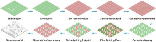
In the process of intelligent generation, first, according to the preset parameters and constraints, an area suitable for urban planning and design is selected from the available plots. Then, through the analysis of the plot outline and street parameters, the plot is divided into regular street blocks. On this basis, by setting the curvature of the road, the main road has the characteristic of a zigzag to adapt to the complex shape and curve characteristics of the city’s historical district. The next step in the generation process is to connect the divided street blocks to form the main transportation network of the city. At the same time, according to the setting of alleyway parameters, alleyways are generated to increase traffic flow and connectivity. The remaining available plots are screened and used for building generation, and the building area is generated according to the design requirements and the division direction of the building footprint. The plots that cannot be used for buildings are used as landscape areas to increase the greening and aesthetics of the city. In the final stage of the intelligent generation process, intelligent algorithms and genetic algorithms are used to adjust and optimize the generated parameters and rules to achieve design goals and constraints. This process is one of continuous iteration and optimization. Through quantitative and qualitative evaluation, the generated design results can be displayed, and their effect and feasibility can be verified ().
Figure 16. Multiple designs generated using genetic algorithms.
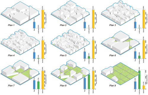
Iterative optimization, result display, and evaluation in the generation process are indispensable links. Iterative optimization is the process of gradually improving and optimizing the generated urban spatial form through multiple iterations and optimizations. In each iteration, the design parameters are finetuned and optimized using an optimization algorithm to bring the resulting design closer to the desired goal. In addition, the generated design results are presented and evaluated through quantitative and qualitative evaluation methods. The building density of historic districts is different from the building density requirements in current urban design. Therefore, the evaluation results in this study are judged based on the land occupation proportions of buildings, landscapes, and roads () to ensure that the generated design scheme meets the expected goals and constraints.
In summary, the intelligent generation process converts design goals and constraints into specific parameters and rules through a series of operations and optimizations and generates urban spatial forms that meet expectations. It makes full use of the advantages of intelligent algorithms and optimization techniques to provide an efficient, flexible, and feasible method for the field of urban planning and design.
4. Conclusions
This study extracts key features from existing historical blocks and transforms them into operable parametric forms by using the technology of Grasshopper parametric programming and genetic algorithms and then generates the best urban spatial design through algorithm optimization. The intelligent generation of the spatial design of the historic district of the island city has been realized, which provides a scientific and innovative reference for urban planning and design, and the following conclusions have been drawn.
Based on the parametric platform that uses Grasshopper, the districts of a new urban design area can effectively be programmed and designed and at the same time the relevant spatial morphological characteristics are reflected through data input.
After completing the programming of the Grasshopper parametric platform, the genetic algorithm can be used to improve and optimize the model obtained through parametric translation to gradually generate urban spatial forms that meet the needs of modern urban design, thereby further enriching the landscape area.
Since Taipa Village is a component of the island-type city, the grasshopper-applied urban design area is also a significant waterfront space for the island-type city. Therefore, the extraction of historical district features and generative application should be consistent to achieve the best results. For example, if a model is compiled based on the characteristics of the historic districts of an island city and applied to the historic districts of an inland city, there may be mismatches or unsatisfactory results. However, Grasshopper has powerful programming and design assistance capabilities, and the design standards are determined according to the needs of the site. Therefore, it is also important to combine the best urban spatial design with the principles of sustainable development by working closely with the right people to ensure that the results are both possible and useful.
In this study, the feature extraction of the spatial design of the island city’s historic districts includes a very large amount of data, such as the width, depth and area of street blocks, street length and average width, street orientation, and building face width, depth, acreage, height, and orientation. It also relies heavily on long-term fieldwork by researchers. Conversely, if not enough data are collected, the compilation of the Grasshopper program will produce inaccurate results.
The method proposed in this study can basically realize the intelligent generation of the spatial design of the island city’s historic district. This comprehensive application can provide scientific and innovative references for urban planning and design while taking into account the requirements of historical and cultural protection and sustainable development. With the rise of big data and artificial intelligence, work efficiency has improved, and the fatigue caused by repetitive and boring work has been alleviated. However, it is difficult for computer technology to replace human subjective thinking, and it is difficult for it to capture the wisdom and local memories of emotions in traditional historical culture. Historic districts are the remnants of the continuation of the regional historical context and the home of cultural heritage to which modern society attaches great importance to protecting.
Modern architects or urban planners can think more about sustainable design and the application of artificial intelligence to continue the historical context. Historic districts are also part of the public space of modern cities and will still have broader opportunities for promotion and application in the future. For example, the research directions that can be considered in the future are as follows: (1) Not limited to the historical blocks of island cities, historical blocks in other regional cultural backgrounds can also continue to consider their street systems and architectural data. In this way, the programming of Grasshopper is redeveloped, expanded, and validated for greater universality. (2) Not limited to the historical blocks in the city, there are also core areas of architectural heritage in traditional villages, which can also be considered in combination with research and design in the future. (3) In addition to Grasshopper, there are many methods of artificial intelligence or intelligent design, such as semantic segmentation in machine learning and CGAN for generative design, which can be incorporated into future research in combination with Grasshopper.
Author contributions
Conceptualization, Y.C.; methodology, L.Z. and L.Y.; software, L.Z. and L.Y.; validation, L.Z. and L.Y.; formal analysis, Y.C. and L.Z.; investigation, Y.C. and L.Z.; resources, Y.C.; data curation, Y.C.; writ-ing – original draft preparation, Y.C. and L.Z.; writing – review and editing, Y.C. and L.Z.; visual-ization, L.Z.; supervision, Y.C. and L.Z.; project administration, Y.C. and L.Z.; funding acquisition, Y.C. and L.Z. All authors have read and agreed to the published version of the manuscript.
Informed consent statement
Not applicable for studies not involving humans.
Institutional review board statement
Not applicable for studies not involving humans or animals.
Disclosure statement
No potential conflict of interest was reported by the author(s).
Data availability statement
The datasets used and analyzed during the current study are available from the corresponding author on reasonable request.
Additional information
Funding
Notes on contributors
Yile Chen
Yile Chen is a PhD candidate in architecture at the Faculty of Humanities and Arts, Macau University of Science and Technology. Her research interests are urban design and renewal.
Liang Zheng
Liang Zheng is a PhD candidate in architecture at the Faculty of Humanities and Arts, Macau University of Science and Technology. His research interests include sustainable architectural design.
Lina Yan
Lina Yan is a PhD candidate in architecture at the Faculty of Humanities and Arts, Macau University of Science and Technology. Her research interests are urban design and renewal.
References
- About Taipa Village – Authentic Macau. Accessed March 2, 2023. https://www.taipavillagemacau.com/about/.
- Ali, H. H., I. A. Al-Hashimi, and F. Al-Samman. 2018. “Investigating the Applicability of Sustainable Urban Form and Design to Traditional Cities, Case Study: The Old City of Sana’a.” Archnet-IJAR: International Journal of Architectural Research 12 (2): 57. https://doi.org/10.26687/archnet-ijar.v12i2.1391.
- AlSadaty, A. 2022. “A Typological Approach to Maintain Character in Historic Urban Areas.” Urban Design International 27 (3): 198–210. https://doi.org/10.1057/s41289-022-00181-1.
- Arghavan, F., S. Lotfi, M. Sholeh, and Hajipoor, K. 2022. “Typo-Morphological Analysis of the Metamorphic Course of the Lar Old City’s Historical Urban Fabric Blocks.” Journal of Architecture and Urban Planning 15 (37): 49–72.
- The Athens Charter in the context of CIAM history. 2023. CIAM (International Congresses of Modern Architecture). Accessed March, 2023 https://www.open.edu/openlearn/history-the-arts/history/heritage/ciam-congres-internationaux-darchitecture-moderne
- Benkõ, M. 2011. “Budapest Urban Blocks and Their Sustainability.” Architektúra & Urbanizmus 45 (3–4): 186–199.
- Borsi, K., N. Porter, and M. Nottingham. 2016. “The Typology of the Berlin Block: History, Continuity and Spatial Performance.” ATHENS JOURNAL of ARCHITECTURE 2 (1): 45–64. https://doi.org/10.30958/aja.2-1-3.
- Central Government Portal.The third national cultural relics census was successfully completed and achieved extremely fruitful results. Accessed March 2, 2023. http://www.gov.cn/gzdt/2012-07/24/content_2190563.htm.
- Chen, F., and O. Romice. 2009. “Preserving the Cultural Identity of Chinese Cities in Urban Design Through a Typomorphological Approach.” Urban Design International 14 (1): 36–54. https://doi.org/10.1057/udi.2009.6.
- Consultation Text of New Urban Master Planning, The Land and Urban Construction Bureau of the Macau Special Administrative Region. Accessed March 2, 2023. https://urbanplanning.dsscu.gov.mo/cn/download/2nd_consultation.pdf.
- De Luca, F. 2019. “Environmental Performance-Driven Urban Design: Parametric Design Method for the Integration of Daylight and Urban Comfort Analysis in Cold Climates.” Computer-Aided Architectural Design.“Hello, Culture” 18th International Conference, CAAD Futures 2019, Daejeon, Republic of Korea, Springer Singapore, 15–31. June 26–28, 2019, Selected Papers 18.
- Ding, C., K. P. Lam, and N. H. Wong. 2016. “Coupled Natural Ventilation Modeling for Contextual Parametric Design Decision Support.” Procedia Engineering 169:264–271. https://doi.org/10.1016/j.proeng.2016.10.032.
- Ding, W., Q. Wei, J. Jin, J. Nie, F. Zhang, X. Zhou, and Y. Ma. 2023. “Research on Public Space Micro-Renewal Strategy of Historical and Cultural Blocks in Sanhe Ancient Town Under Perception Quantification.” Sustainability 15 (3): 2790. https://doi.org/10.3390/su15032790.
- Ferreira, M., J. Lima, T. Freire, and P. Faria. 2017. “Edifícios de adobe e taipa na região de Leiria, Portugal. Levantamento material e documental com vista à sua conservação e reabilitação.” In Congresso da Reabilitação do Património, 31–40. Aveiro,Portugal: Universidade de Aveiro.
- Grzybek, H., S. Xu, S. Gulliver, and V. Fillingham. 2014. “Considering the Feasibility of Semantic Model Design in the Built-Environment.” Buildings 4 (4): 849–879. https://doi.org/10.3390/buildings4040849.
- Guo, K., and Y. Cao. 2021. “Application of Planning Evaluation of Historical Block Based on Space Syntax——Case Study: Third Streets and Two Alleys Historical Block, Nanning.” IOP Conference Series: Earth and Environmental Science 768 (1): 012139. https://doi.org/10.1088/1755-1315/768/1/012139.
- Han, Z., W. Yan, and G. Liu. 2021. “A Performance-Based Urban Block Generative Design Using Deep Reinforcement Learning and Computer Vision.” Proceedings of the 2020 DigitalFUTURES: The 2nd International Conference on Computational Design and Robotic Fabrication (CDRF 2020), College of Architecture and Urban Planning, Tongji University, Shanghai, China, 134–143. Springer Singapore.
- Kim, H. J., W. S. Choi, and J. W. Kim. 2022. “A Study on Parametric Design Tool for Residential Buildings Securing Valid Sunlight Hours on the Winter Solstice.” Journal of Asian Architecture and Building Engineering 21 (5): 1657–1676. https://doi.org/10.1080/13467581.2021.2007108.
- Kongphunphin, C., and M. Srivanit. 2022. “Classifying Essential Morphological Characteristics to Understanding Urbanity in the Old Town of Chiang Mai.” Proceedings of 2021 4th International Conference on Civil Engineering and Architecture, 413–423. Singapore: Springer Nature Singapore.
- Li, N. 2010. “Preserving Urban Landscapes as Public History: The Chinese Context.” The Public Historian 32 (4): 51–61. https://doi.org/10.1525/tph.2010.32.4.51.
- Li, Z., X. Sun, S. Zhao, and H. Zuo. 2021. “Integrating Eye-Movement Analysis and the Semantic Differential Method to Analyze the Visual Effect of a Traditional Commercial Block in Hefei, China.” Frontiers of Architectural Research 10 (2): 317–331. https://doi.org/10.1016/j.foar.2021.01.002.
- Liu, X., L. Tang, Y. Yi, and Z. Ni. 2019. “Intelligent Design Based on Holographic Model Using Parametric Design Method.” Journal of Ambient Intelligence and Humanized Computing 10 (3): 1241–1255. https://doi.org/10.1007/s12652-018-0775-6.
- Mansouri, M., and N. Ujang. 2017. “Space Syntax Analysis of tourists’ Movement Patterns in the Historical District of Kuala Lumpur, Malaysia.” Journal of Urbanism: International Research on Placemaking and Urban Sustainability 10 (2): 163–180. https://doi.org/10.1080/17549175.2016.1213309.
- Naselli, F. 2021. “Tirana-Next: A Complementary Development Strategy (And Consequent Urban Tactics) for the Informal and Historical Urban Fabrics within Tirana Super Blocks.” Current Challenges in Architecture and Urbanism in Albania 61–77. https://doi.org/10.1007/978-3-030-81919-4_5.
- Önder, D. E., and Y. Gigi. 2010. “Reading Urban Spaces by the Space-Syntax Method: A Proposal for the South Haliç Region.” Cities 27 (4): 260–271. https://doi.org/10.1016/j.cities.2009.12.006.
- People’s Daily.The fourth national cultural relics census will be launched. Accessed March 2, 2023. http://paper.people.com.cn/rmrbhwb/html/2023-01/06/content_25958039.htm.
- Ramnath, S., J. Ma, J. J. Shah, and Detwiler, D. 2021. “Intelligent Design Prediction Aided by Non-Uniform Parametric Study and Machine Learning in Feature Based Product Development.” International Design Engineering Technical Conferences and Computers and Information in Engineering Conference. American Society of Mechanical Engineers, 85376:V002T02A025.
- Salem, N., M. Abdelall, H. Ayad, and Zeyad El-Sayad, Z. 2016. “The Implementations of Parametric Design Tool in the Urban Environment to Achieve Quality of Life.” Proceedings of 2016 2nd International Conference on Architecture, Structure and Civil Engineering (ICASCE’16), 26–27. London (UK): March.
- Schnabel, M. A., Y. Zhang, and S. Aydin. 2017. “Using Parametric Modelling in Form-Based Code Design for High-Dense Cities.” Procedia Engineering 180:1379–1387. https://doi.org/10.1016/j.proeng.2017.04.301.
- Tong, Q. 2007. “Protection and Utilization of Historical Buildings in Macao.” Central China Arch 8 (25): 206–210.
- Tong, Q., and J. Sheng. 2005. “Urban Planning and Development in Macao.” Engineering Journal Wuhan University 6 (38): 115–119.
- Urbanization website.Demolish the building and be done?. Accessed March 2, 2023. http://www.ciudsrc.com/webdiceng.php?id=136078.html.
- von Richthofen, A., K. Knecht, Y. Miao, and R. König. 2018. “The ‘Urban Elements’ Method for Teaching Parametric Urban Design to Professionals.” Frontiers of Architectural Research 7 (4): 573–587. https://doi.org/10.1016/j.foar.2018.08.002.
- Wang, X., Y. Song, and P. Tang. 2020. “Generative Urban Design Using Shape Grammar and Block Morphological Analysis.” Frontiers of Architectural Research 9 (4): 914–924. https://doi.org/10.1016/j.foar.2020.09.001.
- Weng, W., J. Wu, and L. Bao. 2020. “The Regeneration of Traditional Residential Block with Typological Approach-Taking Zhongnongli in Nanjing as an Example.” IOP Conference Series: Materials Science & Engineering 960 (4): 042037. https://doi.org/10.1088/1757-899X/960/4/042037.
- Xie, Q., F. A. Ursini, and G. Samo. 2023. “Urbanonyms in Macao.” Names 71 (1): 29–43. https://doi.org/10.5195/names.2023.2421.
- Xu, Y., J. Rollo, J. D. S, Y. Esteban, H. Tong, and Q. Mu. 2020. “Towards Sustainable Heritage Tourism: A Space Syntax-Based Analysis Method to Improve tourists’ Spatial Cognition in Chinese Historic Districts.” Buildings 10 (2): 29. https://doi.org/10.3390/buildings10020029.
- Yao, Z., and C. Jiang. 2020. “Imitation, Reference, and Exploration—Development Path to Urban Renewal in China (1985-2017).” Journal of Urban History 46 (4): 728–746. https://doi.org/10.1177/0096144218822803.
- Yuan, C., and E. Ng. 2012. “Building Porosity for Better Urban Ventilation in High-Density Cities–A Computational Parametric Study.” Building and Environment 50:176–189. https://doi.org/10.1016/j.buildenv.2011.10.023.
- Yu, H., J. TSOU, and J. G. Long. 2009. Space Syntax Analysis of Foshan Street Network Transformation in Support Historic Area Redevelopment. Delft, Netherlands: Yildiz Technical University.
- Zou, Y. October 2020. “Research on the Activation of the Old City Zone from the Perspective of Community Construction-Taking Front of Customs Street in Macau as an Example.” IOP Conference Series: Earth and Environmental Science 580 (1): 012084. IOP Publishing. https://doi.org/10.1088/1755-1315/580/1/012084.
Appendix A:
Grasshopper environment configuration
Grasshopper environment configuration: The operating system is Windows 11 (X64), the Grasshopper version is Friday, 07 May 2021 19:00 Build 1.0.0007, the Rhinoceros version is 7 SR6 (7.6.21127.19001,2021-05-07), and the processor is AMD Ryzen 9 5900HX (3.30 GHz).
Appendix B:
Investigation and statistics of the data of 25 streets in Taipa Village
The researchers collected the data for 25 streets in Taipa Village through on-the-spot investigation.
Table