
 ?Mathematical formulae have been encoded as MathML and are displayed in this HTML version using MathJax in order to improve their display. Uncheck the box to turn MathJax off. This feature requires Javascript. Click on a formula to zoom.
ABSTRACT
Tourism development promotes economic income and cultural protection of traditional villages, but it also disturbs their landscape pattern and ecosystem. This study is aim to explore the process characteristics and mechanisms of the impact of tourism development on the landscape pattern of traditional villages. Taking Huangcheng Village, a typical tourism-oriented traditional village as a case, this research selects four remote sensing images from 1995 to 2020 according to its key time nodes of tourism development, analyzes its landscape expansion and pattern change, and uses Geodetector to explore influencing factors. The results show that: (1) The landscape change mainly presents the non-natural landscape continuously occupying the natural landscape, and expands continuously around tourist resources in edge-expansion and leapfrog-expansion manner, among which the expansion from 2003 to 2011 is the most significant; (2) The dominance and connectivity of non-natural landscape are enhanced, and the overall landscape pattern experiences a “relatively complete – tending to fragmentation – tending to completeness” change process; (3) The dominant factors affecting landscape pattern have stage characteristics. The results emphasize the role of tourism-related socio-economic and policy factors in influencing landscape pattern, which is significant for the landscape pattern optimization and sustainable development of tourist-type traditional villages.
1. Introduction
Traditional villages refer to villages with tangible and intangible cultural heritage with high historical, cultural, scientific, artistic, social and economic values (Chen, Xie, and Li Citation2020). As of August 2023, a total of six batches of 8155 villages have been included in the “Chinese Traditional Villages” protection list. In recent years, tourism development has become a common choice for traditional villages, and has played an important role in promoting the economic income, industrial upgrading and cultural continuity of rural areas (Lane & Kastenholz Citation2015). However, under the blind and high-intensity tourism development and construction activities, traditional villages are facing problems such as landscape pattern disturbance, ecosystem background damage, etc., which greatly affect the ecological and cultural landscape security of traditional villages (Liu et al. Citation2020). Therefore, revealing the current situation of the landscape pattern of traditional villages under tourism development is of great significance for implementing feasible spatial planning and landscape pattern protection and optimization policies. It is necessary to carry out research on the spatio-temporal change and influencing factors of the landscape pattern of tourist-type traditional villages, to promote the ecological and cultural protection of traditional villages, and to achieve sustainable development of rural areas.
The landscape pattern of traditional villages is the result of the interaction between human activities and natural environment, which can reflect the spatial structure characteristics and functions of traditional villages. Landscape pattern change is an important content of landscape ecology theory research, which is the direct spatial representation of landscape heterogeneity (Luck and Wu Citation2002), and also the result of various ecological processes at different scales (Medeiros et al. Citation2022). The landscape pattern index analysis method based on the attributes of landscape geometric features is now a common choice for quantitative study of landscape pattern evolution, and analytical models such as Markov and FLUS are also gradually used in the simulation analysis of future landscape pattern evolution (Tariq and Shu Citation2020). However, some scholars have pointed out that the ecological significance of a single landscape pattern index is not strong, and it cannot effectively guide the regional maintenance of biodiversity and ecosystem stability. Some scholars have also proposed methods to measure the dynamic evolution and characteristics of landscape by using landscape expansion index (LEI) (Liu et al. Citation2010) and landscape evolution scale index (LECI) (Cao et al. Citation2022). Compared with the traditional landscape index, they can more intuitively reflect the process of dominant landscape expansion. In urban and rural ecosystem, the main landscape change category is often the expansion of non-natural landscape. Introducing LEI combined with landscape pattern index analysis can more comprehensively reveal the form and process characteristics of landscape pattern evolution.In terms of the selection of research scales, previous studies have often focused on the study of landscape pattern changes at large scales, including provincial and municipal levels (Li et al. Citation2022), watersheds (Yang et al. Citation2022), and mountainous areas (Zhang et al. Citation2020). These studies are more instructive for the spatial planning of the above macro-regions, but due to the lack of specific detail information, they are of limited instructive significance for the spatial planning of the small and medium scale rural areas therein, and it is necessary to carry out the research on the change of landscape pattern of traditional villages under the influence of tourism at the village scale.
At present, research on the landscape pattern of rural areas from the perspectives of urbanization (Li and Song Citation2020), industrialization (Zhang et al. Citation2020) and agricultural development (Ferrari & Rambonilaza Citation2008) is more common, while the understanding of the landscape pattern evolution of rural areas from the perspective of tourism development is relatively lacking. It is believed that tourism development significant impact on the dynamic change of landscape pattern (Xi et al. Citation2014), and some studies have also revealed that the landscape pattern evolution and tourism development are dynamic and bidirectional processes (Botequilha-Leitão and Diáz-Varela Citation2018), forming a coupling relationship of “tourism development-land use-landscape pattern” (Ayhan et al. Citation2020). However, the explanation of the influencing factors and process mechanisms is mostly through qualitative description, and the quantitative identification and analysis of the influencing elements is insufficient.
Huangcheng Village is a typical tourist-oriented traditional village in China because it has a national AAAAA-level tourist attraction. Tourism has greatly promoted the development of the village. However, long-term high-intensity tourism development activities have disturbed the original landscape pattern. Although Huangcheng Village has paid attention to ecological issues in recent years, and has formulated and carried out a series of natural environment and heritage protection projects. But due to the lack of systematic understanding of the process mechanism of landscape pattern change under the influence of tourism, the ecological and cultural landscape security of the village still face potential threats. Therefore, this study takes Huangcheng Village as the research area and studies the spatio-temporal change and influencing factors of the landscape pattern of tourist-type traditional villages. The purpose of this study is to: (1) Sort out the tourism development process, divide the research period, and analyze the land use transfer and expansion process during the research period; (2) Analyze the landscape pattern change characteristics from the type and landscape levels through the landscape pattern index; (3) Use the single-factor detection of the geographic detector to identify and quantitatively analyze the influencing factors, and try to explore the process mechanism of tourism influencing landscape pattern change; (4) Put forward the protection and optimization strategies of the landscape pattern of tourist-type traditional villages. In order to provide a reference for the landscape pattern optimization and green sustainable development of traditional villages under tourism development.
2. Materials and methods
2.1. Study area
2.1.1. Overview of study area
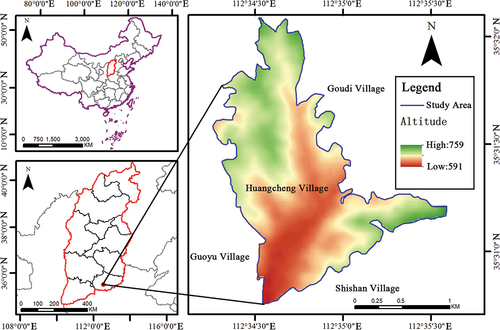
Huangcheng Village is located in Beiliu Town, Yangcheng County, Jincheng City, in the southeast of Shanxi Province. It is situated in the Taihang Mountain area, with an area of 2.5 square kilometers(). The Fanxi River flows from east to west through the village. It is one of the first batch of traditional villages in China, and also the location of the national AAAAA-level tourist attraction: Huangcheng Xiangfu Scenic Spot. Huangcheng Xiangfu is an ancient architectural complex that integrates ancient residences, official mansions, sacrificial temples and defensive fortifications. It combines official regulations and local traditions in architectural craftsmanship, reflecting the strict feudal etiquette and unique architectural culture of the feudal society in Shanxi region (Zhong et al. Citation2007). The profound celebrity culture and concentrated historical relics have created rich and concentrated cultural tourism resources for Huangcheng Village. In recent years, with the large-scale tourism development and high-intensity tourism activities, its village landscape pattern has undergone significant changes.
Figure 1. Location of the study area (from the author).
2.1.2. The development history of tourism in the study area
Before 2002, it was the industrial transformation stage. Before developing tourism, Huangcheng Village relied on its rich coal resources to open Huanglian Coal Mine, accumulating a relatively strong economic foundation. In order to avoid decline due to resource exhaustion, Huangcheng Village began to adjust its industrial structure and develop tourism economy since 1998, transferring a large amount of funds accumulated in the early stage to the protection, restoration and tourism development projects of historical architectural remains such as Huangcheng Xiangfu and Xishan Courtyard. It started to receive tourists the next year, and became Huangcheng Xiangfu Ecological and Cultural Tourism Zone in 2002.
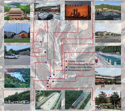
2003–2010 was the rapid development stage. As the number of tourists in Huangcheng Village began to scale up, the tourist carrying capacity of the scenic area needed to be improved. During this period, not only new tourist attractions such as Xiaokang New Community, Xiangfu Manor, and Ecological Sightseeing Garden were built for tourists to visit and stay, but also a large number of public service facilities for tourism such as transportation, accommodation, catering and entertainment were added to match the scenic area ().
Figure 2. The distribution of the main tourism public service facilities in huangcheng village (from the author).
2011 to present is the quality improvement stage. During this period, Huangcheng Xiangfu Ecological and Cultural Tourism Zone was upgraded to a national AAAAA-level scenic spot, further integrating the tourism resources of surrounding villages. It receives more than 2 million domestic and foreign tourists every year, with a comprehensive tourism income exceeding 500million yuan, driving nearly 3,000 people from the whole village and surrounding villages such as Guoyu and Shishan to work, forming a complete industrial chain. Nowadays, the main tourist attractions in Huangcheng Village include Huangcheng Xiangfu, Ziyunqian (Chen’s ancestral tomb), Fanxi River, Xishan Courtyard, Xiaokang New Community, Shancheng Coal Mine, etc.
2.2. Data source and Preprocessing
The data mainly come from three aspects: ① the field data collected during the field investigation in Huangcheng Village, and the relevant economic and social data obtained from interviews with the local village committee and tourist area; ② the materials obtained from consulting the local chronicles, statistical yearbooks and literature related to the research area; ③ the Landsat series remote sensing image data downloaded from the geographic spatial data cloud platform (GScloud), combined with Google Earth image data, using ENVI software for human-computer interactive visual interpretation, to obtain the landscape distribution of Huangcheng Village in each research period.
2.3. Research methods
2.3.1. Land use dynamics
Land use dynamics is a measure of the intensity of change of a certain type of landscape or a certain region in a certain research period. It includes two dimensions: single land use dynamics and comprehensive land use dynamics (Xiao et al. Citation2022). The specific formulas are as follows:
represents the single land use dynamics, which is the change rate of a certain landscape type in the research period;
and
represent the area size of that landscape type at the beginning and end of the research period; T is the length of the research period.
represents the comprehensive land use dynamics, which is the change rate of the whole study area in the research period;
represents the area of the ith landscape type at the beginning and end of the research period;
is the absolute value of the area of the ith landscape type transformed into non-ith landscape type in the research period;
is the length of the research period (Li, Liu, and Huang Citation2017).
2.3.2. Landscape expansion index
Landscape Expansion Index (LEI) is defined based on buffer analysis, which contains the process information of landscape change, compared with the traditional landscape indices that can only reflect the spatial characteristics of a single time point (Shi et al. Citation2012). It can be used to identify the dynamic change process and characteristics of landscape expansion. It is often applied to analyze the expansion mode of urban construction land. This paper introduces LEI to analyze the spatial expansion process of construction land within the village area.
is the landscape expansion index of a new landscape patch;
is the overlapping area of the buffer unit and the initial patch;
is the difference between the buffer unit and
. The value range is 0-100. When 50 <
≤ 100, it can be judged as infilling-expansion; when 0 <
≤ 50, it is edge-expansion; when
= 0, it is leapfrog-expansion (Woldesemayat and Genovese Citation2021).
2.3.3. Landscape pattern index
Landscape pattern indices are important parameters that reflect the characteristics of landscape patterns. They highly condense the information of landscape patterns, including the landscape level and the type level, and characterize the landscape pattern characteristics from multiple aspects such as scale, shape, connectivity, and fragmentation (Q. Zhang et al. Citation2020). This paper selects the indices that are widely used in previous studies and uses Fragstats4.2 to calculate them (Zhu, Wang, and Sakai Citation2019). The following indicators are selected at the landscape level: Contagion (CONTAG), Landscape Division Index (DIVISION), Shannon’s Diversity Index (SHDI), Shannon’s Evenness Index (SHEI); the following indicators are selected at the type level: Total Area (CA), Largest Patch Index (LPI), Patch Density (PD), Patch Cohesion Index (COHESION).
2.3.4. Geodetector
Geodetector is a new statistical method to measure the spatial heterogeneity of geographic features and reveal their underlying influencing factors (Liu et al. Citation2022). It is good at detecting the driving forces of categorical variables and analyzing the interaction effects of factors. It consists of four parts: risk detector, factor detector, ecological detector and interaction detector (Zhao et al. Citation2020). This study mainly uses the “factor detector” function of Geodetector based on grid division to analyze the response intensity between the landscape pattern representation change and its influencing factors within the village area (Chen et al. Citation2023). The influence size is measured by q value, which ranges from. The larger the value, the stronger the explanatory power of the factor on the landscape pattern change, and vice versa. The formula is as follows:
In the formula, = 1, 2, 3, … , R is the stratification of variable Y or factor X;
and
are the sample sizes of the stratification and the whole region;
and
are the variances of Y values in layer h and the whole region.
Referring to the previous research and combining the characteristics of tourism-oriented traditional villages, this paper selects the following eight factors that affect the landscape pattern from three dimensions: natural, socio-economic and policy: elevation (X1), slope (X2), distance to river (X3), distance to scenic spot (X4), distance to road (X5), population density (X6), distance to village committee (X7), and spatial development and protection policy coverage (X8)().
Table 1. Geodetector influence factor selection.
3. Results
3.1. Landscape classification results and change characteristics
3.1.1. Analysis of landscape area change characteristics
The land use landscape types of Huangcheng Village are determined as: construction land, forest land, cultivated land and water. According to and , which reflect the spatial distribution and area of land use landscape types in Huangcheng Village in different periods, forest land is the main landscape type in the village area, accounting for 61.22%-68.77%, and the area change shows a fluctuating trend, from 195.64 hm2 in 1995 to 186.72 hm2 in 2003, and then slightly rebounded to 189.45 hm2 from 2003 to 2011, and decreased to 174.14 hm2 in 2020. Construction land is the second largest landscape type in the village area, accounting for 11.61%-35.33%, and overall shows a trend of continuous expansion, from 33.03 hm2 (1995) to 100.49 hm2 (2020). Cultivated land and water have the smallest landscape areas, accounting for 2.89%-18.96% and 0.26%-0.66% respectively. The cultivated land area shows a trend of continuous decrease, from 53.92 hm2 to 8.22 hm2. The water area showed a sharp decrease trend from 1995 to 2011, and gradually increased from 2011 to 2020, but the area still decreased by 0.26 hm2 during the research period.
Figure 3. Landscape classification of huangcheng village in 1995, 2003, 2011 and 2020 (from the author).
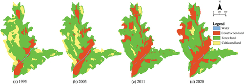
Table 2. Area and proportion of each landscape type in huangcheng village from 1995 to 2020.
3.1.2. Analysis of land use dynamics
According to , the comprehensive land use dynamic degree of Huangcheng Village shows a trend of rising first and then falling, with the most dramatic dynamics from 2003 to 2011, with a comprehensive land use dynamic degree of 1.62%, and relatively stable from 2011 to 2020. From 1995 to 2003, the land use dynamic degree of construction land was the highest, followed by cultivated land, forest land and water. From 2003 to 2011, most land use landscape types increased, and the dynamics of cultivated land and construction land were relatively intense. From 2011 to 2020, the dynamic degree of construction land and cultivated land decreased, while the dynamic degree of forest land and water increased.
Table 3. The dynamic degree of each landscape type in huangcheng village from 1995 to 2020.
3.1.3. Analysis of landscape transition process
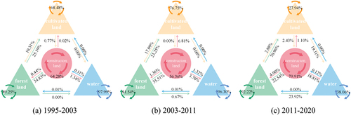
According to , it can be seen that: from 1995 to 2003, forest land mainly transferred to construction land and cultivated land; cultivated land mainly transferred to forest land (10.31%); 34.83% of construction land came from forest land; water changed relatively stable. From 2003 to 2011, forest land continued to transfer to construction land and cultivated land, respectively transferring 35.51% and 23.25%; new construction land mainly came from forest land, and most of the water area was converted into construction land. From 2011 to 2020, construction land mainly came from forest land and cultivated land, and water came from forest land (23.92%) and cultivated land (19.11%). Overall, the mutual transfer between forest land and cultivated land was more frequent, and forest land and cultivated land constantly transferred to construction land.
Figure 4. Landscape transition progress in huangcheng village from 1995 to 2020 (From the author).
3.1.4. Analysis of landscape expansion
According to , it can be seen that during the research period, the expansion forms of construction land in Huangcheng Village were mainly edge-expansion and leapfrog-expansion, accounting for 75.46% and 18.78% of the total area of new construction land, respectively. The expansion of construction land in the village area was most significant from 2003 to 2011, with a total expansion area accounting for 45.46% of the total expansion area during the research period. As can be seen from , the expansion center experienced a trend of moving from the upstream of Fanxi River to the northeast, and then to the Xiangfu Manor scenic area in the northwest. Among them, from 1995 to 2003, Huangcheng Village mainly expanded construction land in edge-expansion and leap-expansion manner, and new land was mainly concentrated on both sides of Fanxi River. From 2003 to 2011, new construction land was mainly concentrated in the Xiangfu Manor area in the northwest and the Shancheng Coal Mine along the east, and the leapfrog-expansion trend was significantly enhanced. From 2011 to 2020, mainly based on the existing construction land, it spread outward, with concentrated contiguous construction areas on both sides of Fanxi River and moderate expansion in the Xiangfu Manor area, with almost no leapfrog-expansion land.
Figure 5. The landscape expansion process of huangcheng village from 1995 to 2020 (from the author).
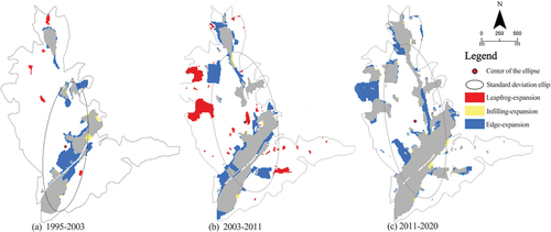
Table 4. The area and proportion of different construction land expansion modes in Huangcheng Village from 1995 to 2020.
3.2. Analysis of changes in the landscape pattern index
3.2.1. Landscape pattern indices at the class level
According to the calculation methods of various landscape pattern indices, the relevant indices of different landscape types in different years of Huangcheng Village were calculated respectively. The results are shown in .
Figure 6. The changes of landscape pattern indices at the class level from 1995 to 2020 (from the author).
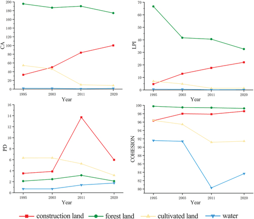
Total Area (CA) and Largest Patch Index (LPI) can reflect the dominant landscape types and change trends in the landscape. CA reflects that the landscape types in the village area are ranked by area size as forest land, construction land, cultivated land and water; LPI reflects the proportion of the largest patch of landscape type to the whole village area, and its value has a positive correlation with the dominance of landscape type. The largest LPI is forest land, followed by construction land, which are the dominant landscape types in the village area and can have a greater impact on the overall landscape. During the research period, LPI of forest land decreased the most, while the dominance of construction land increased continuously, which matched the expansion trend of construction land in Huangcheng Village.
Patch Density (PD) and Patch Cohesion Index (COHESION) can reflect the fragmentation degree and connectivity of landscape. From PD, construction land and cultivated land have higher value, while forest land and water area have lower value, indicating that construction land and cultivated land are more fragmented in landscape, while forest land and water area have better integrity. From 1995 to 2011, PD of construction land, forest land and water increased gradually, indicating that the fragmentation degree of these three landscape types increased in this research period, which was directly related to the rapid expansion of the scenic area. From 2011 to 2020, except for water area, the fragmentation degree of other landscape types slowed down to some extent. From COHESION, forest land and construction land had generally higher cohesion from 1995 to 2020, and did not change significantly during the research period, indicating that their patch connectivity was better, while water area and cultivated land had a downward trend in cohesion.
In summary, during the research period, Huangcheng Village showed the overall characteristics of increasing dominance and patch connectivity of non-natural landscape (construction land), and decreasing dominance and patch connectivity of natural landscape (forest land, cultivated land and water).
3.2.2. Landscape pattern indices at the landscape level
The landscape pattern indices of Huangcheng Village at the landscape level show different trends (). Contagion(CONTAG) showed an overall upward trend during the study period, rising from 60.975% in 1995 to 63.940% in 2020; Landscape Division Index(DIVISION) increased from 0.544% in 1995 to 0.787% in 2020; Shannon’s Diversity Index (SHDI) and Shannon’s Evenness Index (SHEI) both experienced a process of slow increase, rapid decrease, and then slow increase. From the perspective of landscape aggregation, connectivity, and diversity, the landscape pattern of Huangcheng Village underwent a process of “relatively fragmented – tending to be intact – tending to be fragmented”.
Table 5. The changes of landscape pattern indices at the landscape level from 1995 to 2020.
3.3. Changes in the landscape pattern influence factor recognition
Using DEM data to extract elevation and slope in Arcgis, the Euclidean distance method is used to obtain the nearest distance from the grid to the river, road, scenic area, and village committee in the study area, and then the natural breakpoint method is used for discretization. The spatial development and protection policy factors are spatialized after the implementation scope of the corresponding policy within the research period, and the development policy and protection policy coverage are respectively assigned. The data of each influencing factor are imported into the Geodetector for single-factor detection analysis.
According to , it can be seen that DIVISION, SHDI, and SHEI have good explanatory power overall, while CONTAG has low explanatory power. There are significant influencing indicators for each landscape pattern index. The factor detection results of SHDI and SHEI show that the q value with the largest value in 1995 was X1 (elevation), the q value with the largest value in 2003 was X3 (distance to river), and the q value with the largest value in 2011 and 2020 was X8 (spatial development and protection policy). The factor detection results of CONTAG show that X4 (distance to scenic spot) and X8 (spatial development and protection policy) have significant influence, which generally show an upward trend, while X1 (elevation) shows a downward trend; The factor detection results of DIVISION show that X1 (elevation) has maintained a high influence, X3 (distance to river) reached its peak in 2003, and the overall trend was first rising and then falling.
Figure 7. The results of the factor detection of the landscape pattern change in Huangcheng Village (from the author).
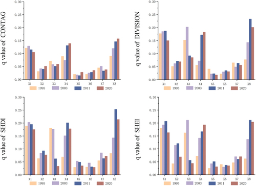
Generally speaking, X1 (elevation) has a generally high influence in each research period, all above 0.1, and is the main influencing factor that causes the landscape pattern of Huangcheng Village to change. X3 (distance to river), X4 (distance to scenic spot), and X8 (spatial development and protection policy) have significant influence in individual research periods, and their changes are large, which are also the dominant factors that cause the landscape pattern of Huangcheng Village to change. Specifically, the landscape pattern of Huangcheng Village was greatly influenced by X3 in the early stage of the research period (1995–2003), and by X4 and X8 in the later stage (2003–2020), that is, in the early stage of tourism development, the natural environment background of the village dominated the landscape pattern change, and with the progress of tourism development activities, scenic area development and spatial planning began to dominate the landscape pattern change of the village area, thus showing a phased characteristic of dominant influencing factors. The other factors have relatively little influence, indicating that in the process of construction and development of Huangcheng Village, their role in landscape pattern change is weak.
4. Discussion
4.1. Influencing factors of landscape pattern change in Huangcheng Village
Based on the quantitative description and analysis of the previous text, combined with the local chronicles and relevant policies, economic and social data, this paper discusses the influencing factors of landscape pattern change in Huangcheng Village from 1995 to 2020 ().
Figure 8. Influence mechanism of land use landscape pattern in huangcheng village (from the author).
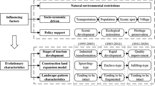
① From 1995 to 2003, it was the industrial transformation stage of Huangcheng Village. At this time, tourism was just starting, and the disturbance of tourism development to the landscape pattern of the village area was small, mainly reflected in the relatively small landscape dynamics and the relatively intact landscape patches at this time. Construction land expanded outward gradually in a edge-expansion manner. Due to the spatial constraints and strict requirements for the protection of ancient buildings in the Huangcheng Xiangfu scenic area, the corresponding infrastructure and service facilities followed the natural topography and terrain, and expanded outward in a sprawling manner from Huangcheng Xiangfu as the starting point along the relatively flat Fanxi River valley upstream, and built supporting facilities such as Xiaoxin Village and leisure square to meet the needs of villagers and tourists. The overall development and construction volume was not large. It can be seen that in this stage, natural environmental conditions were the main influencing factors of landscape pattern change.
② From 2003 to 2011, it was the rapid development stage of tourism in Huangcheng Village. The land use dynamics were the most intense, and the degree of landscape patch fragmentation increased. The main impact of tourism construction on the village landscape was mainly manifested as a large amount of forest land and cultivated land being occupied as construction land, and construction land expanding rapidly outward in leapfrog-expansion and edge-expansion manner. Combined with the tourism development history of Huangcheng Village, it can be seen that in this stage, Huangcheng Xiangfu Ecological Cultural Tourism Scenic Area was created as a national AAAA-level scenic area, and successfully upgraded to a AAAAA-level scenic area. Many affiliated tourist attractions were developed one after another. In order to match the standards of 5A scenic area and better serve tourists, the scenic area continuously improved its supporting infrastructure, spent a lot of money to build supporting service facilities, and occupied a large amount of forest land and cultivated land around the scenic area in this process. But in this stage, the forest land area and forest patch connectivity overall showed an increasing trend, because the local village committee implemented the mountain greening project and garden-style mine construction project around the scenic area to meet the needs of ecological scenic area construction, focusing on integrating and protecting forest land, restoring and creating water areas. In addition, due to the tourism economy driving local villagers to become rich, villagers’ dependence on primary industry decreased, a large amount of cultivated land was idle, lost its original farming value, and then returned farmland to forest. It can be seen that in this stage, the development of scenic area, social economy and policy regulation jointly affected the landscape pattern of Huangcheng Village.
③ From 2011 to 2020, with the continuous improvement of tourism scenic area construction, Huangcheng Village also entered the quality improvement stage. In this stage, the expansion speed of construction land slowed down. There was almost no leapfrog-expansion, but mainly internal improvement and moderate outward expansion. The degree of landscape fragmentation was alleviated compared with the previous stage, landscape connectivity was enhanced, mutual conversion between construction land and forest land was obvious, and a large amount of water area was increased. The reason is that in this stage, Huangcheng Village integrated the low-efficiency industrial and mining construction land and wasteland in the village area through mine ecological restoration, greening barren hills and four mining areas, dredging rivers, and effectively improving the ecological environment of the village area. In addition, Huangcheng Village was selected as one of the first batch of traditional villages in China in 2012. The corresponding heritage protection policy also played a good role in restraining excessive expansion of construction land in Huangcheng Village. Generally speaking, policy formulation and implementation dominated landscape pattern change in this stage.
4.2. Optimization strategies of landscape pattern for tourist-oriented traditional villages
The following strategies should be considered in order to optimize the landscape pattern of tourist-type traditional villages and promote the sustainable development of rural areas.
First, to control the red line of ecological protection strictly as a means of restraining the disorderly expansion of construction land, intensively utilizing land resources, and integrating the functional complementarity between tourism infrastructure, public service facility land and village living space, so as to avoid the fragmentation of ecological resources and the deterioration of the ecological environment caused by the massive encroachment of tourism facility land into the agricultural and forestry land.
Secondly, to build an ecological security pattern (ESP) at the regional level, integrate the fragmented patches of forest land, and ensure the connectivity and integrity of forest land patches; at the same time, to cultivate the waterscape, strengthen the hydrological adjustment capacity, and give full play to its ecosystem and cultural service functions.
Third, adhere to the protective tourism development. On the basis of not destroying the original spatial texture of the village, it can make full use of the peripheral production and ecological space of the village, develop leisure agriculture, recreation and health tourism and other industries, utilize tourism to drive the added value of agricultural products and handicrafts, reduce the phenomenon of farmland abandonment, and further enhance the stability of the landscape patches.
4.3. Research limitations and future research directions
Compared with previous studies, this study discusses the characteristics and influencing factors of the landscape pattern evolution of traditional villages at different stages of tourism development, and reveals the role of tourism-related socio-economic and policy factors in influencing landscape pattern change by quantitative analysis, which can provide reference for the landscape management and sustainable development of traditional villages. However, there are still some limitations in this study:
First, in terms of the selection and processing of remote sensing image data, limited by the spatial scale of the study area and the difficulty of data acquisition, The Landsat remote sensing image data used in this paper has a low spatial resolution and will be affected by various factors during the imaging process, resulting in image quality degradation, noise and variability (Hong et al. Citation2019). It can only reflect the general trend of landscape change in the study area. At present, more and more scholars use machine learning methods to achieve intelligent classification of high-resolution geographic elements (Tariq et al. Citation2022; Yao et al. Citation2023). Therefore, using remote sensing image data with higher accuracy and adopting new methods such as deep learning will be a focus of future research (Li et al. Citation2023; Yao et al. Citation2023).
Second, this research only focuses on a single typical tourist-type traditional village, and the research conclusions are not universal. In the follow-up work, it is necessary to conduct in-depth research on different regional categories and larger research scales, especially the comparative analysis of landscape pattern evolution under different interaction modes between villages and tourist attractions.
Third, when using geographic detector to identify influencing factors, only the influence of single factor was detected. However, when revealing the complexity of geographic phenomena, it is also necessary to consider the logical and structural relationships between different influencing factors (Liu et al. Citation2022). Therefore, in he process of influencing factor analysis, it is necessary to detect and analyze the interactive influence between multiple factors.
Finally, based on the United Nations Sustainable Development Goals (SDGs) for the guidance of ecological environment sustainability, green sustainable development of rural areas should be taken as the goal of protection and development of traditional villages, protect the landscape pattern and cultural heritage of traditional villages, optimize the ecosystem service function, and promote the harmonious development of human and nature.
5. Conclusions
With the development of tourist attractions, the land use landscape type of Huangcheng Village has changed significantly, mainly reflecting the continuous transformation of natural landscape (forest land, cultivated land and waters) into unnatural landscape (construction land); the expansion area of construction land accounted for 25.2% of the area of the village during the study period, and the center of the expansion moved to the upper reaches of the Fanxi River firstly, and then to the scenic area of the Siangfu Manor, and the overall direction of the expansion was in a northwesterly direction, with multiple. The overall expansion direction is northwest, and most of the expansion continues to expand outward around the key tourism resources in types of edge-expansion (75.46%) and leapfrog-expansion (18.78%); among them, the expansion of the construction land from 2003 to 2011 was the most significant, and the total expansion area accounted for 45.46% of the total area of the expansion in the study period, with an increase of 68.2%.
The analysis of landscape pattern at the type level showed that the dominance degree (CA & LPI) and patch connectivity (PD & COHESION) of unnatural landscapes were increasing, while the dominance degree and patch connectivity of natural landscapes were decreasing; and the analysis of landscape pattern at the landscape level showed that the landscape pattern of Huangcheng Village went through the process of “complete – fragmented -relatively complete”.
A variety of factors jointly influence the process of landscape pattern change of the tourist-type traditional villages, and the dominant influencing factors are also different due to the different stages of tourism development and construction. Natural environment, socio-economic and policy factors jointly influence the landscape pattern of traditional villages, and present stage differences, in which the influence of socio-economic factors, mainly scenic accessibility, as well as tourism-related spatial development and protection policy factors, increases significantly over time.
The results of this study emphasize the role of tourism-related socio-economic and policy factors in influencing the landscape pattern changes of traditional villages, which can provide a valuable reference basis for the optimization of the landscape pattern of tourism-based traditional villages and green sustainable development. In the future, this study can be based on SDGs and use deep learning and other methods to conduct research related to multi-scenario simulation of landscape patterns.
Acknowledgements
The research was funded by the National Natural Science Foundation of China (51778610); Xuzhou Basic Research Program General Project (KC22048); the Postgraduate Research Innovation Program of Jiangsu Province (KYCX23_2841).
Disclosure statement
No potential conflict of interest was reported by the author(s).
Additional information
Funding
Notes on contributors
Zurui Lin
Dr. Zurui Lin is a professor at the School of Architecture and Design, China University of Mining and Technology. His main research interests include vernacular architectural heritage conservation, renewal and sustainable development of historical and cultural villages. In recent years, he has been mainly devoted to the conservation and renewal practices of traditional villages in the Taihang Mountain.
Kaiyi Chen
Kaiyi Chen is a master’s student at the School of Architecture and Design, China University of Mining and Technology. His research interests include rural planning and design, landscape ecology of rural settlements, and conservation and renewal of traditional villages.
Kai Jiao
Kai Jiao is a master’s student at the School of Geography, Geomatics and Planning, Jiangsu Normal University. His research interests include rural land use and landscape pattern evolution, regional ecological environment quality monitoring and land use planning.
Zixuan Li
Zixuan Li is a master’s student at the School of Architecture and Design, China University of Mining and Technology. His research interests include rural planning and design, ecological restoration planning and natural resource management.
References
- Ayhan, C. K., T. C. Tasli, F. Ozkok, and H. Tatli. 2020. “Land Use Suitability Analysis of Rural Tourism Activities: Yenice, Turkey.” Tourism Management 76:103949. https://doi.org/10.1016/j.tourman.2019.07.003.
- Botequilha-Leitão, A., and E. Diáz-Varela. 2018. “An Alternative Planning Paradigm for Coastal Landscapes and Tourism: Spatial Metrics as Indicators for Planning Coastal Tourism Landscapes.” Tourism & Management Studies 14 (1): 45–57. https://doi.org/10.18089/tms.2018.14104.
- Cao, H., J. Chen, C. Chen, and P. Li. 2022. “Identification of Multi-Temporal Urban Growth Patterns with a Modified Urban Growth Index: Case Study of Three Fast Growing Cities in the Greater Mekong Subregion (GMS).” Ecological Indicators 142:109206. https://doi.org/10.1016/j.ecolind.2022.109206.
- Chen, X., W. Xie, and H. Li. 2020. “The Spatial Evolution Process, Characteristics and Driving Factors of Traditional Villages from the Perspective of the Cultural Ecosystem: A Case Study of Chengkan Village.” Habitat International 104:102250. https://doi.org/10.1016/j.habitatint.2020.102250.
- Chen, W., L. Yang, J. Wu, J. Wu, G. Wang, J. Bian, J. Zeng, and Z. Liu. 2023. “Spatio-Temporal Characteristics and Influencing Factors of Traditional Villages in the Yangtze River Basin: A Geodetector Model.” Heritage Science 11 (1): 111. https://doi.org/10.1186/s40494-023-00948-x.
- Ferrari, S., & Rambonilaza, M. (2008). Agricultural multifunctionality promoting policies and the safeguarding of rural landscapes: How to evaluate the link? Landscape Research, 33(3), 297–309. https://doi.org/10.1080/01426390802045947
- Hong, D., N. Yokoya, J. Chanussot, and X. X. Zhu. 2019. “An Augmented Linear Mixing Model to Address Spectral Variability for Hyperspectral Unmixing.” IEEE Transactions on Image Processing 28 (4): 1923–1938. https://doi.org/10.1109/TIP.2018.2878958.
- Lane, B., & Kastenholz, E. (2015). Rural tourism: The evolution of practice and research approaches - towards a new generation concept? Journal of Sustainable Tourism, 23(8–9), 1133–1156. https://doi.org/10.1080/09669582.2015.1083997.
- Li, M., X. Li, S. Liu, X. Lyu, D. Dang, H. Dou, and K. Wang. 2022. “Analysis of the Spatiotemporal Variation of Landscape Patterns and Their Driving Factors in Inner Mongolia from 2000 to 2015.” LAND 11 (9): 1410. https://doi.org/10.3390/land11091410.
- Li, Y., G. Liu, and C. Huang. 2017. “Dynamic Changes Analysis and Hotspots Detection of Land Use in the Central Core Functional Area of Jing-Jin-Ji from 2000 to 2015 Based on Remote Sensing Data.” Mathematical Problems in Engineering 2017:2183585. https://doi.org/10.1155/2017/2183585.
- Li, H., and W. Song. 2020. “Evolution of Rural Settlements in the Tongzhou District of Beijing Under the New-Type Urbanization Policies.” Habitat International 101:102198. https://doi.org/10.1016/j.habitatint.2020.102198.
- Liu, X., X. Li, Y. Chen, Z. Tan, S. Li, and B. Ai. 2010. “A New Landscape Index for Quantifying Urban Expansion Using Multi-Temporal Remotely Sensed Data.” Landscape Ecology 25 (5): 671–682. https://doi.org/10.1007/s10980-010-9454-5.
- Liu, Y., L. Liu, S. Lu, and Q. Zhang. 2020. “Ecological Landscape Resource Management and Sustainable Development of Traditional Villages.” Journal of Environmental Protection and Ecology 21 (5): 1938–1949.
- Liu, J., Q. Xu, J. Yi, and X. Huang. 2022. “Analysis of the Heterogeneity of Urban Expansion Landscape Patterns and Driving Factors Based on a Combined Multi-Order Adjacency Index and Geodetector Model.” Ecological Indicators 136:108655. https://doi.org/10.1016/j.ecolind.2022.108655.
- Li, C., B. Zhang, D. Hong, J. Yao, and J. Chanussot. 2023. “LRR-Net: An Interpretable Deep Unfolding Network for Hyperspectral Anomaly Detection.” IEEE Transactions on Geoscience and Remote Sensing 61:1–12. https://doi.org/10.1109/TGRS.2023.3279834.
- Luck, M., and J. G. Wu. 2002. “A Gradient Analysis of Urban Landscape Pattern: A Case Study from the Phoenix Metropolitan Region, Arizona, USA.” Landscape Ecology 17 (4): 327–339. https://doi.org/10.1023/A:1020512723753.
- Medeiros, A., C. Fernandes, J. F. Goncalves, and P. Farinha-Marques. 2022. “A Diagnostic Framework for Assessing Land-Use Change Impacts on Landscape Pattern and Character—A Case-Study from the Douro Region, Portugal.” Landscape and Urban Planning 228:104580. https://doi.org/10.1016/j.landurbplan.2022.104580.
- Shi, Y., X. Sun, X. Zhu, Y. Li, and L. Mei. 2012. “Characterizing Growth Types and Analyzing Growth Density Distribution in Response to Urban Growth Patterns in Peri-Urban Areas of Lianyungang City.” Landscape and Urban Planning 105 (4): 425–433. https://doi.org/10.1016/j.landurbplan.2012.01.017.
- Tariq, A., and H. Shu. 2020. “CA-Markov Chain Analysis of Seasonal Land Surface Temperature and Land Use Land Cover Change Using Optical Multi-Temporal Satellite Data of Faisalabad, Pakistan.” Remote Sensing 12 (20): 3402. Article 20. https://doi.org/10.3390/rs12203402.
- Tariq, A., H. Shu, S. Siddiqui, I. Munir, A. Sharifi, Q. Li, and L. Lu. 2022. “Spatio-Temporal Analysis of Forest Fire Events in the Margalla Hills, Islamabad, Pakistan Using Socio-Economic and Environmental Variable Data with Machine Learning Methods.” Journal of Forestry Research 33 (1): 183–194. https://doi.org/10.1007/s11676-021-01354-4.
- Woldesemayat, E. M., and P. V. Genovese. 2021. “Monitoring Urban Expansion and Urban Green Spaces Change in Addis Ababa: Directional and Zonal Analysis Integrated with Landscape Expansion Index.” Forests 12 (4): 389. https://doi.org/10.3390/f12040389.
- Xiao, X., X. Huang, L. Jiang, and C. Jin. 2022. “Empirical Study on Comparative Analysis of Dynamic Degree Differences of Land Use Based on the Optimization Model.” Geocarto International 37 (25): 9847–9864. https://doi.org/10.1080/10106049.2022.2025919.
- Xi, J., M. Zhao, Q. Ge, and Q. Kong. 2014. “Changes in Land Use of a Village Driven by Over 25 Years of Tourism: The Case of Gougezhuang Village, China.” Land Use Policy 40:119–130. https://doi.org/10.1016/j.landusepol.2013.11.014.
- Yang, H., X. Zhong, S. Deng, and S. Nie. 2022. “Impact of LUCC on Landscape Pattern in the Yangtze River Basin During 2001-2019.” Ecological Informatics 69:101631. https://doi.org/10.1016/j.ecoinf.2022.101631.
- Yao, J., B. Zhang, C. Li, D. Hong, and J. Chanussot. 2023. “Extended Vision Transformer (ExVit) for Land Use and Land Cover Classification: A Multimodal Deep Learning Framework.” IEEE Transactions on Geoscience and Remote Sensing 61:1–15. https://doi.org/10.1109/TGRS.2023.3284671.
- Zhang, Q., C. Chen, J. Wang, D. Yang, Y. Zhang, Z. Wang, and M. Gao. 2020. “The Spatial Granularity Effect, Changing Landscape Patterns, and Suitable Landscape Metrics in the Three Gorges Reservoir Area, 1995-2015.” Ecological Indicators 114:106259. https://doi.org/10.1016/j.ecolind.2020.106259.
- Zhang, C., W. Kuang, J. Wu, J. Liu, and H. Tian. 2020. “Industrial Land Expansion in Rural China Threatens Environmental Securities.” Frontiers of Environmental Science & Engineering 15 (2): 29. https://doi.org/10.1007/s11783-020-1321-2.
- Zhao, R., L. Zhan, M. Yao, and L. Yang. 2020. “A Geographically Weighted Regression Model Augmented by Geodetector Analysis and Principal Component Analysis for the Spatial Distribution of PM2.5.” Sustainable Cities and Society 56:102106. https://doi.org/10.1016/j.scs.2020.102106.
- Zhong, J., J. Zhang, D. Li, Y. Zhao, S. Lu, and C. Shi. 2007. “Nodes and Field of Tourist Origins to Ancient Village—A Case Study of Huangcheng Village in Shanxi Province of China.” Chinese Geographical Science 17 (3): 280–287. https://doi.org/10.1007/s11769-007-0280-x.
- Zhu, Y., C. Wang, and T. Sakai. 2019. “Remote Sensing-Based Analysis of Landscape Pattern Evolution in Industrial Rural Areas: A Case of Southern Jiangsu, China.” Sustainability 11 (18): 4994. https://doi.org/10.3390/su11184994.