
ABSTRACT
In the contemporary urban landscape, the rail mass transit system assumes a crucial role in shaping city tourism, primarily attributable to its commendable efficiency in ensuring safety and optimizing travel times. A comprehensive understanding of this system becomes imperative for formulating strategies aimed at augmenting the tourism potential it facilitates. Consequently, this study employs rigorous spatial analysis, concentrating on tourist attractions and their accessibility levels within the Transit-Oriented Development (TOD) center and an area outside the TOD center (non-TOD). The empirical results of this investigation unveil that the distribution characteristics of a substantial proportion of tourist attractions manifest clustering tendencies (Z-score exceeding 1.65), particularly in areas synonymous with historical and recreational activities. In contrast, specific activities such as cultural and agricultural pursuits exhibit a random distribution characteristic (Z-score between −1.65 and 1.65). Notably, it becomes apparent that activities characterized by distinct distribution patterns also harbour varying potentials for accessibility. In essence, this scholarly endeavour contributes nuanced insights into the intersection of urban rail mass transit systems and tourism dynamics, shedding light on the intricate relationships between spatial distribution, activity characteristics, and accessibility levels within diverse urban contexts.
Graphical abstract
1. Introduction
In the recent 2030 Agenda for Global Action, encompassing the Sustainable Development Goals (United Nations Citation2022), Goal 11 specifically emphasizes the principles of “Making cities and human settlements inclusive, safe, resilient, and sustainable” (United Nations Citation2022). This goal extends its purview to tourism and recreation by advocating for the implementation of universal design in accessible and sustainable transport systems. Recognizing tourism as a key sector in national economies, it serves as a substantial asset for enhancing a country’s competitiveness and global visibility. Notably, sustainable tourism assumes a critical role, given that tourism stands as one of the world’s major industries, actively contributing to economic stimulation and generating substantial employment opportunities. The advancement of tourism necessitates the utilization of various urban resources, potentially giving rise to numerous issues if not adeptly managed. The interplay between tourism traffic and urban traffic, particularly the dependence on personal vehicles for tourism travel, poses a challenge to the development of tourism and sustainable transportation systems. Relying on personal vehicles for travel introduces complications with far-reaching consequences, including traffic congestion, road accidents, and pollution issues (Gao and Liao Citation2023; Psarras, Panagiotidis, and Andronikidis Citation2023).
Hence, the prevailing trajectory of tourism development places a heightened emphasis on sustainability, centering on the natural capacity and the ability to accommodate tourists. The paradigm of smart mobility and tourism has transitioned from a technology-centric approach to one that underscores sustainable solutions to address local economic concerns. Urban tourism and public transport are intricately intertwined, showcasing a mutually beneficial relationship where public transport assumes a pivotal role in the development of tourism at a destination (Le-Klähn and Hall Citation2014). Rail mass transit stands out as a sustainable mobility option, contributing significantly to sustainable tourism, particularly in addressing transportation challenges. Serving as an alternative for public transportation, rail mass transit operates on a dedicated system separate from roads, presenting an efficient mode of travel within predefined timeframes (Ling, BiHu, and Hua Citation2011). Notably, in proximity to mass transit stations, there is a concentration of mixed activities, rendering these areas as hubs with diverse options for activities within walking distance. In numerous countries, the Transit-Oriented Development (TOD) concept has been implemented as a key strategy in urban and town development, coupled with the enhancement of transportation infrastructure. This approach centers on integrated community development and supports judicious land use, encouraging residents to reside in close proximity to transportation service centers with the aim of minimizing reliance on personal vehicles. The promotion of accessibility through safe and convenient public transport is a crucial prerequisite for the tourism sector, particularly in the context of inner-city tourism. Therefore, advocating for the advancement of the rail mass transit system, coupled with a concentrated focus on the development of the surrounding station area, holds significance. This approach not only enhances the accessibility to tourist attractions via public transport but also provides a range of mixed land-use activities and supporting amenities within the station vicinity. Numerous studies have underscored the crucial connection between mass transit development and the promotion of tourism (Chang and Lai Citation2009; Kangsheng et al. Citation2021; Ling, BiHu, and Hua Citation2011). However, many of these studies predominantly explore the impact of various mass transit systems on diverse tourism aspects, including city buses, bus rapid transit, heavy and light rail, monorails, among others.
In Thailand, Bangkok serves as the nation’s capital and is a magnet for both Thai and international tourists. Within Bangkok’s mass transit system, various modes such as rapid transit, city buses, subway, monorails, etc., coexist. However, the public bus transportation system grapples with challenges related to inefficiencies in terms of quality and time management. Consequently, the development of the rail mass transit system emerges as a critical factor supporting multifaceted growth in Bangkok and its surrounding metropolitan areas, including urban tourism. The anticipated outcome of this study is to shed light on strategies for improving access to tourist attractions within the city by leveraging the rail mass transit system. The study aims to achieve a comprehensive understanding of the spatial distribution characteristics of tourist destinations, emphasizing the role of the rail mass transit system in facilitating access. Additionally, the study seeks to evaluate the potential for future enhancements in accessibility to tourist destinations within the city. By focusing on these objectives, the study aims to provide valuable insights for urban planners, policymakers, and transportation authorities. The findings can inform decision-making processes related to the development and optimization of the rail mass transit system, contributing to the creation of a more accessible, efficient, and appealing urban environment for both residents and tourists. Ultimately, the study aspires to contribute to the sustainable and integrated development of transportation infrastructure to support the growth of tourism within the city.
2. Literature review
2.1. Transit-oriented development and its accessibility
Transit-oriented development (TOD) was initially introduced in the early post-war period and has evolved over time (Ibraeva et al. Citation2020). Presently, TOD is increasingly embraced by numerous cities worldwide, emerging as a critical strategy in urban planning, particularly in the context of fostering long-term sustainable urban development (Fang et al. Citation2023; Ibraeva et al. Citation2020). Generally, TOD constitutes an integral component of the public transport system (Black, Tara, and Pakzad Citation2016). It is rapidly gaining prominence globally, especially in densely populated cities where movement for work, shopping, recreation/tourism, and transportation of goods, among other activities, is a prevalent concern (Chan et al. Citation2016). Transit-Oriented Development (TOD) is a city and town development concept that aligns with the evolution of transportation infrastructure. It involves creating mixed-use areas, integrating commercial centers, shops, residences, employment sources, and other activities. This approach centers in the vicinity around bus stations or along rail mass transit systems, with a focus on areas reachable by walking (approximately 500 meters) from the bus station. The objective is to transform the community around the station into a high-quality, livable environment – a desirable place to reside, invest, and conduct business. This strategy aims to enhance travel activities, both inbound and outbound, through public transportation and encourages non-motorized travel within the area to reduce reliance on cars (Hasibuan et al. Citation2014; Office of Transport and Traffic Policy and Planning Citation2023).
Transit-Oriented Development (TOD) demands the establishment of a compact, connected, pedestrian-oriented environment, and mixed-use development within a quarter-mile radius of a mass transit station (Calthorpe Citation1993; Chan et al. Citation2016). This imperative arises from the diverse urban context, encompassing regional centers, urban cores, original communities, and other specialized areas that permit the development of various types of TOD. These may include TOD stations of the urban center type, TOD stations of the neighbourhood center type, and so forth. Each TOD station type assumes distinct roles and exhibits characteristic activities within its defined area, typically ranging from 300 to 1,000 meters or more, with an average around 500 meters (Center for Transit-Oriented Development Citation2007). In the context of tourism development, the surroundings of the station must exhibit characteristics of activities, uses, and facilities that can cater to the needs of tourists, enabling them to fully immerse themselves in the tourism experience. Consequently, the area necessitates thoughtful design to support and integrate with other public transportation systems, incorporate usage features relevant to hotels and accommodations, and prioritize the creation of easily understandable road signs. Additionally, there should be an emphasis on promoting the conservation of cultural and natural areas (Office of Transport and Traffic Policy and Planning Citation2021). The expansion of transit not only contributes to enhanced connectivity and urban mobility but also significantly influences the dynamics of urban tourism.
2.2. Mass transit for the sustainable development of tourist attractions
Transportation serves as a fundamental catalyst for tourism, playing a crucial role in facilitating access to tourist attractions from the inception of the journey through to the destination (Lohmann and Pearce Citation2012; Rhoden Citation2006). While traveling by car remains the most convenient and flexible mode of transportation, reliance on private vehicles entails various consequences (Jiang et al. Citation2017). Consequently, there is a growing emphasis in urban planning and design on developing more sustainable alternative transportation systems (He Citation2015). This includes promoting pedestrian-friendly environments, cycling infrastructure, and the use of public transport. Mass transit systems encompass various modes, including city buses, bus rapid transit, heavy and light rail, monorails, among others. Among these, rail mass transit, in particular, has demonstrated a substantial enhancement in transportation service quality and accessibility, yielding positive effects on station real estate and urban economics.
Numerous studies have explored the utilization of rail mass transit in the context of tourism. For example, Chang and Lai (Citation2009) conducted a study focusing on the analysis of tourism attractions along the Taipei MRT. The results indicated that perceptions of Taipei MRT tourism attractions are statistically dependent on differences in socio-economic characteristics and travel behaviors. Kangsheng et al. (Citation2021) conducted a study on the impact of urban rail transit on the tourism economy, revealing a connection that creates development opportunities for urban tourism economies. Additionally, Ling et al. (Citation2011) emphasized the significance of mass transit in urban tourist transportation, advocating for its development to enhance accessibility to all destinations within a city The importance of rail mass transit in the context of tourism can be understood through its dual role (Ling, BiHu, and Hua Citation2011).
Firstly, as “rail mass transit for tourism”, it serves as a crucial means of providing access to tourist attractions. This emphasizes the significance of a well-connected and efficient rail network that allows tourists to easily reach various points of interest, contributing to the accessibility and attractiveness of destinations. Secondly, as “rail mass transit as tourism”, the focus shifts to the journey itself. Rail transportation, especially in areas near transit stations, offers passengers a unique experience of comfort and scenic enjoyment (Ling, BiHu, and Hua Citation2011; Nagari, Suryani, and Pratiwi Citation2020). This dual role recognizes that travel experience is an integral part of tourism. The efficiency and appeal of the rail mass transit system contribute not only to the convenience of reaching destinations but also to the overall satisfaction and enjoyment of the journey itself. In essence, the dual role of rail mass transit in tourism highlights its multifaceted impact, not only facilitating travel logistics but also enhancing the overall tourism experience for passengers. This recognition is crucial for urban planners, policymakers, and stakeholders in developing and optimizing rail mass transit systems to meet the diverse needs and expectations of both local residents and tourists (Nagari, Suryani, and Pratiwi Citation2020; Ramos-Santiago and Brown Citation2016).
3. Methodology
3.1. Data design and study area
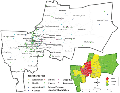
In the context of Thailand, Bangkok, often referred to as the “Mega City” (), stands out as a bustling urban center with a population exceeding 5 million people. The city is teeming with diverse activities, offering a myriad of opportunities spanning educational institutions, employment options, and housing, ranging from the general to high-end segments. From a tourism perspective, Bangkok holds paramount importance, serving as a significant destination for both local and international tourists. However, owing to its population size and the intensity of activities, the city’s transportation system, responsible for facilitating the movement of people and goods within its precincts, contends with substantial traffic. Bangkok is notably characterized as the area facing the most acute traffic congestion challenges in the country.
Figure 1. Study area: Bangkok, the Capital of Thailand.
Despite the availability of numerous alternative transportation systems in the city, a significant proportion of citizens still opt to rely on personal vehicles. Over the past decade, Thailand has witnessed rapid economic growth and a surge in tourism in major regional cities, leading to pronounced traffic issues in these areas. The landscape of urban travel has transformed, witnessing an uptick in the utilization of public transportation. In the case of Bangkok, particular emphasis has been placed on the development of the rail mass transit system. This strategic focus is enshrined in the 20-year master plan for the rail mass transit system in Bangkok and surrounding areas (M-MAP2) covering the period 2010 to 2029. Serving as a guiding framework for various agencies, the Ministry of Transport and related entities have consistently worked towards the development of the rail mass transit system in Bangkok and its vicinities. However, the city’s dynamics have undergone transformations due to population settlements, the expansion of the business sector, and urban development resulting from the implementation of the M-MAP plan. These changes aim to bring about a tangible shift in people’s travel patterns, directing them towards the city center area through the public transportation system. Consequently, there has been a continuous refinement of the development plan to establish guidelines for the evolution of the rail mass transit system, aligning it with the prevailing urban growth situation. The emphasis is on enhancing connectivity with the public mass transit system and fostering the judicious development of the areas around the stations (Office of Transport and Traffic Policy and Planning Citation2017). Presently, the rail mass transit system in the city takes the form of key components, including the BTS Skytrain, the Metropolitan Rapid Transit Authority, and the Suvarnabhumi Airport Skytrain Link. Additionally, there are ongoing construction projects and plans awaiting implementation.
In terms of the data utilized for the analysis, it encompasses two main aspects: (1) tourist attraction data, which includes location information for various types of attractions such as historical, cultural, agricultural, shopping, recreational, and educational sites related to arts and sciences; (2) rail mass transit system data, which includes station locations and route information for existing operational lines as well as those anticipated for future operation. Both components constitute secondary data derived from the databases of the Department of Public Works and Town & Country Planning.
3.2. Data analysis
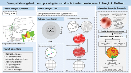
This study concentrates on enhancing access to tourist attractions within the city through the rail mass transit system, aiming to comprehend the spatial distribution characteristics and assess the potential for facilitating access to these attractions in the future. The analysis in this study places a particular emphasis on spatial analysis, delving into density characteristics, distribution patterns, and accessibility through the application of various geographic information systems (GIS) methods. The analytical process is delineated into four steps, as illustrated in .
Figure 2. Framework.
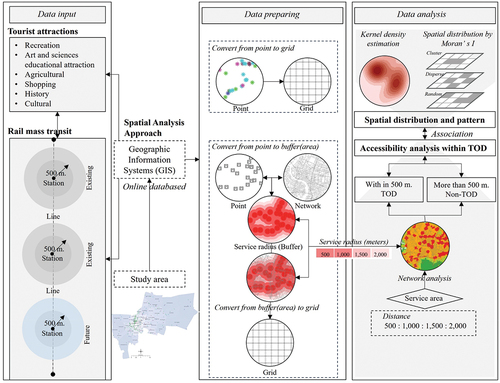
To begin, the study assesses the density of all six tourist attraction activities using the kernel density estimation tool, a prominent technique in Geographic Information System (GIS) analysis. Kernel density estimation (KDE) is a statistical method of significant utility, wherein the kernel function is assessed individually for each data point, subsequently combining partial results to generate the KDE (Soh et al. Citation2013). In this specific application, the output cell size is set to 100, with square kilometers serving as the unit of area. Secondly, an examination is undertaken to discern the nature of the distribution of tourist attraction points within each type, as activities in each category possess distinct characteristics, contributing to an uneven spatial distribution (Iamtrakul, Chayphong, and Crizzle Citation2023). Comprehending the distribution patterns of activity sources aids in the consideration of connections when allocating suitable travel modes, including assessing investment potential in tourism.
The spatial autocorrelation tool, namely Global Moran’s I, is utilized to assess the spatial distribution patterns of each tourist attractions. This tool assesses whether the expressed pattern is clustered, dispersed, or random, representing one of the spatial autocorrelation methods applied across various dimensions, such as road safety, tourism, health, etc. (Shi, Han, and Guo Citation2020; Soltani and Askari Citation2017; Lisiak-Zielińska and Ziernicka-Wojtaszek Citation2021). The tool produces a Z-score and p-value, aiding in the assessment of the significance of Moran’s index. Global Moran’s I ranges from −1 to 1, where a value approaching −1 indicates negative spatial autocorrelation or dispersion, and a value approaching 1 indicates positive spatial autocorrelation or clustering (Lisiak-Zielińska and Ziernicka-Wojtaszek Citation2021). Moran’s I and Z-score are crucial statistical tools that can significantly support the investigation into the relationship between the rail mass transit system and the distribution patterns of tourist attractions (J. Wang et al. Citation2023). They can contribute to a broader urban growth strategy with an emphasis on transit-oriented development (TOD). Here’s how Moran’s I and Z-score can support this investigation. Moran’s I is a spatial autocorrelation statistic that measures the characteristic of spatial clustering or dispersion of data points (Lisiak-Zielińska and Ziernicka-Wojtaszek Citation2021; Shi, Han, and Guo Citation2020; Soltani and Askari Citation2017). The Z-score is used to assess the statistical significance of Moran’s I. It indicates how many standard deviations a particular observation (in this case, Moran’s I) is from the mean. When Z is positive and significant, it indicates a significant positive correlation, meaning similar observations tend to cluster in space (Xia et al. Citation2021). A high Z-score (either positive or negative) suggests a significant spatial pattern.
Thirdly, accessibility is examined through the application of network analysis tools, categorizing access distances into four levels: 500, 1,000, 1,500, and 2,000 meters. Following the accessibility assessment, the accessibility levels are further categorized based on distances from the rail mass transit station, distinguishing between the area within the Transit-Oriented Development (TOD) center (within 500 meters) and the area outside the TOD center (non-TOD: more than 500 meters). In conclusion, employ geographic information systems to visualize factor values for each variable, and subsequently present all the data using an analytical grid size of 500 × 500 sq. m. The proposed approach offers several benefits. By subjecting data on tourist attractions and accessibility levels to a statistical significance test, the study aims to unravel the intricate relationship between the characteristics of tourist attractions and their accessibility within the Transit-Oriented Development (TOD) center and the area outside the TOD center (non-TOD). This rigorous analysis is instrumental in providing insights into the spatial patterns associated with tourist attractions and their accessibility. The significance of this statistical exploration lies in its potential to guide informed recommendations. The findings from this analysis will serve as a foundation for strategic suggestions aimed at enhancing the travel capacity through the mass transit system, specifically addressing the dynamics of tourist attraction activities within the Bangkok area. Consequently, the proposed approach contributes to evidence-based decision-making in urban planning and transportation management, fostering the development of a more efficient and accessible mass transit system for both residents and tourists.
4. Results
4.1. Spatial distribution of tourist attractions
Bangkok is renowned as a global tourist destination, attracting visitors from around the world. The city offers diverse forms of tourism activities, allowing tourists to immerse themselves in entertainment, recreation, and Thai culture. Each type of tourism activity is characterized by its unique location and format. For this study, tourist attractions were sourced from an online database, categorized into six types of activities: historical, cultural, agricultural, shopping, recreational, and educational attractions related to arts and sciences.
From , the estimated values for the activity density of tourist attractions reveal distinct concentrations. Historical tourist attractions exhibit the highest density, followed by arts and sciences educational, recreation, and shopping. Overall, these concentrations can be categorized into two forms: Tourist attractions concentrated in the city center and surrounding areas, including arts and sciences educational (KDE score = 0–1.034), historical (KDE score = 0–4.248), recreation (KDE score = 0–0.737), and shopping (KDE score = 0–0.309). Tourist attractions scattered on the outskirts encompass agricultural (KDE score = 0–0.011) and cultural (KDE score = 0–0.042). Concerning the physical distribution characteristics assessed using Global Moran’s I, this analysis helps illustrate the spatial distribution features of tourist attractions within the Bangkok area. From , it is evident that the distribution pattern of tourist attractions can be classified into two types of classifications: 1) clusters (arts and sciences educational (z-score = 10.139), historical (z-score = 28.365), recreation (z-score = 11.387), and shopping (z-score = 5.015)) and 2) random (agricultural (z-score = −0.118) and cultural (z-score = −0.290).
Figure 3. Density of tourist attractions.
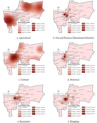
Table 1. Spatial distribution of tourist attraction.
The distribution of tourist destinations reflects the distinctive characteristics of activities, with recreational activities, shopping, and arts and sciences education concentrated within the city. Conversely, agricultural, and cultural tourist attractions are dispersed in suburban areas distant from the city center. This pattern arises due to the city center being characterized by dense residential and commercial activities, leaving no room for agricultural areas conducive to agricultural tourism, which is instead facilitated in the surrounding suburbs.
4.2. Potential access to tourist attractions via rail mass transit
Assess the potential for accessing the rail mass transit system by conducting network analysis based on service radius and network distance. Access distances are categorized into four levels: 500, 1,000, 1,500, and 2,000 meters. illustrates the determination of the scope of access distances at different levels using the buffer analysis technique. presents the outcomes of the accessibility analysis via the rail mass transit system, incorporating information on the locations of mass transit service points. This information is divided into two parts: rail mass transit stations currently operational (as of the year 2022) and those expected to commence service in the future, including some stations under construction and others outlined in the development plan.
Figure 4. Rail mass transit within Bangkok.
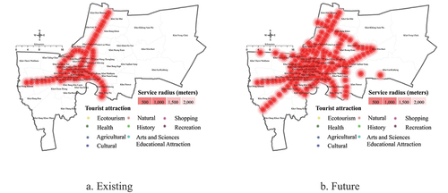
Figure 5. Potential access to tourist attraction by rail mass transit.
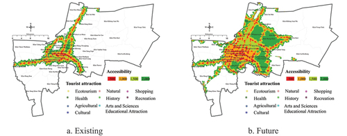
The analysis process adopts a three-level classification to comprehensively assess the accessibility landscape of tourist attractions in relation to the rail mass transit system. The data reveals that, despite the anticipated expansion of the transit system, certain attractions remain inaccessible by rail. The classification categorizes accessibility levels into three distinct groups: attractions within the Transit-Oriented Development (TOD) center (within 500 meters), those outside the TOD center (more than 500 meters), and areas beyond TOD (>2,000 meters). This nuanced approach provides a detailed understanding of the proximity of attractions to transit stations, highlighting those easily reachable and those requiring additional modes of transportation or infrastructure improvements. The classification aids as demonstrated in in formulating targeted recommendations for enhancing the travel capacity through the mass transit system, offering valuable insights for urban planners and policymakers to create a more efficient and accessible urban environment for residents and tourists alike.
Table 2. Potential access to tourist attractions by rail mass transit.
In , the potential for accessing various forms of tourist attractions through the rail mass transit system is presented. Upon considering the overall average accessibility within the range of 0–2,000 meters, it is observed that agricultural tourism attractions fall outside the service radius of 2,000 meters or more. Regarding tourist attraction activities in shopping, arts, and sciences education, cultural, recreation, and historical areas, these can be reached within 0–800 meters from the rail mass transit station. Among them, shopping tourist attractions exhibit the greatest accessibility, with an average distance of 330 meters. When examined independently based on the levels of TOD center, non-TOD center, and areas outside TOD boundaries, it was identified that more than 30 percent are situated outside the service radius of the rail mass transit system (exceeding 2,000 meters). Significantly, when scrutinized in terms of statistical significance, it was discerned that the average values differ at each TOD level, exerting a notable impact on accessibility to tourist attractions.
5. Discussion
The study results reveal that tourist attractions exhibit two distinct distribution characteristics: random and clustered. When considered in conjunction with accessibility, it becomes evident that tourist attractions possess specific characteristics. The results indicate that there are two types of distribution characteristics: clustered, with a z-score in the range of 5.02–28.37, and random, with a z-score in the range of −0.12 – −0.29. The random distribution is relatively non-statistically significant concerning differences in access across TOD levels. In contrast, tourist attractions demonstrating clustered distribution characteristics display high statistical significance. This implies that the average level of access to each type of tourist attraction varies significantly within the TOD region. Nevertheless, the diversity of tourist attraction types introduces various considerations, and each type caters to the distinct needs of different tourists. Certain types, such as natural and historical attractions, may face constraints in being located within walking distance from a rail mass transit station. Despite the fact that over 34 percent (113 places) of tourist attractions lie outside the service area of the rail mass transit system, this presents a significant challenge demanding supportive measures in terms of connectivity to enhance more flexible travel. In the urban context, it is evident that tourist attractions are concentrated in the inner-city area, characterized by high density and diversity of land use activities, particularly residential and commercial land use. Additionally, this area serves as a hub for various modes of travel, including rail mass transit systems, waterways, and other public transport systems. In contrast, tourist attractions in the outer city area are more dispersed. Many studies emphasize that an efficient mass transit system serves suggested greater to reach tourism and special activity centre-related destinations and as a pivotal factor in driving the growth of the tourism industry (Ling, BiHu, and Hua Citation2011; Nagari, Suryani, and Pratiwi Citation2020; Ramos-Santiago and Brown Citation2016). The highly efficient rail transportation network, such as mass rapid transit systems, greatly reduces intercity transportation congestion (Baum-Snow and Kahn Citation2000). With the potential of the transportation system, if it can promote and encourage travel by rail mass transit for tourism, it will also help alleviate congestion resulting from tourist travel volumes. This, in turn, contributes to improving environmental sustainability in urban development and transportation systems.
However, while many studies highlight the potential of rail mass transit development to reduce traffic volumes, some studies indicate that it has no significant effect on altering private car travel patterns (J. Wang et al. Citation2023), posing a challenge to development. Beyond its role in efficiently accommodating tourists annually through swift and convenient public transportation services, the rail transportation system plays a crucial role in supporting overall economic growth and enhancing the country’s capabilities (Chang and Lai Citation2009; Kangsheng et al., Citation2021). Opting for rail transportation is a crucial strategy in alleviating dependence on vehicles for travel, thereby exerting a sustained impact on reducing road traffic associated with travel for various purposes. However, even when considered alongside future plans for the development of the rail mass transit system, it is apparent that there will be service routes expanding the service area further in the future. Nevertheless, due to the unique nature of certain tourist destinations, some activities still have limited access via public transportation. Therefore, an important policy to enhance the potential for traveling to tourist attractions via the rail mass transit system is to promote a feeder system, which increases the potential for connecting travel from the rail mass transit system to tourist attractions.
6. Conclusion
Over the last decade, the momentum in urban planning has championed the transformative role of mass transit stations, positioning them as catalysts for development and implementing transit-oriented development as a central pillar for urban growth. The three-level classification whatever kernel density analysis, spatial autocorrelation (Global Moran’s I), and accessibility in TOD region. These use in the analysis process aligns with the overarching objective of integrating transit-oriented development (TOD) as a central element for urban growth. With a focus on enhancing access to tourist attractions in the city, this study strategically leverages the rail mass transit system. The primary aim is to investigate and understand the spatial distribution characteristics of tourist destinations and tap into the system’s potential to facilitate easy access to these attractions. By implementing TOD principles, which prioritize mixed-use development around transit hubs, the study aims to unlock opportunities for seamless travel experiences. The investigation goes beyond mere expansion considerations, investigating into the intricate relationship between the rail mass transit system and the distribution patterns of tourist attractions. This approach aligns with a broader urban growth strategy, emphasizing the role of transit-oriented development in fostering accessibility and connectivity within the city. In this context, Moran’s I can help identify whether there is a spatial pattern or clustering in the distribution of tourist attractions around rail mass transit stations. A positive Moran’s I indicates clustering, suggesting that similar values (tourist attractions) are close to each other, while a negative Moran’s I suggests dispersion. Understanding the spatial autocorrelation of tourist attractions provides insights into whether certain types of attractions tend to be located close to each other or are more dispersed, thereby informing decisions related to the development of the rail mass transit system.
By considering the Z-score, the investigation can determine whether the observed spatial pattern is statistically significant. This helps researchers and planners distinguish between patterns that may occur by chance and those that are meaningful, guiding decisions on the development of transit-oriented infrastructure. In essence, Moran’s I and Z-score provide a robust framework for analysing the spatial relationships between tourist attractions and rail mass transit stations (Gumbo and Moyo Citation2020; J. Wang et al. Citation2023). By integrating these statistical measures, the investigation gains a quantitative basis for understanding the intricacies of the distribution patterns. This, in turn, supports evidence-based decisions in the broader urban growth strategy, ensuring that transit-oriented development aligns effectively with the spatial characteristics of tourist attractions for enhanced accessibility and connectivity within the city. The findings underline the importance of prioritizing and boosting tourism through the rail mass transit system, signalling a need for city and tourism planners to intricately plan a transportation system that seamlessly connects the journey from station to tourist attractions, enhancing the flexibility of travel. However, it’s worth noting that this study has its limitations; it does not delve into the intricacies of travel behaviour data and tourist attitudes, which are crucial aspects for steering the future of travel towards greater sustainability.
Disclosure statement
No potential conflict of interest was reported by the author(s).
Additional information
Funding
Notes on contributors
Pawinee Iamtrakul
Assoc. Prof. Pawinee Iamtrakul, a Thai national, she currently serves as a lecturer at the Department of Urban Environmental Planning and Development, Faculty of Architecture and Planning, Thammasat University, Thailand. Additionally, she holds the position of Director at the Center of Excellence in Urban Mobility Research and Innovation (UMRI) at Thammasat University. Her research interests lie in the fields of Urban and Transportation planning, encompassing various aspects of urban transport, including sustainable transport, road safety, public transport, and non-motorization. Moreover, her expertise extends to integrated planning, considering the integration of all urban elements such as land use, infrastructure, economics, social factors, and the environment. E-mail: [email protected]
Sararad Chayphong
Ms. Sararad Chayphong, a Thai national, she is a Ph.D. student affiliated with the Center of Excellence in Urban Mobility Research and Innovation (UMRI) within the Faculty of Architecture and Planning at Thammasat University, Thailand. Her current research focuses on the links between transportation choices and public health, aiming to uncover insights that contribute to the creation of healthier and more sustainable urban environments. Ultimately, her research aspirations revolve around providing valuable recommendations and insights that can shape the future of urban development, emphasizing efficiency, sustainability, and the well-being of urban populations. E-mail: [email protected]
Ducksu Seo
Dr. Ducksu Seo is an urban design and planning professor at Handong Global University in South Korea. He is also an urbanist leading several international urban projects and housing studies. Dr. Seo enjoys conducting field research abroad and collaborating with global partners to advance the paradigm of sustainable smart cities in emerging world cities. He has published numerous academic papers on urban networks and regional centrality, slum upgrading, sustainable housing development, and citizen participation in urban projects. E-mail: [email protected]
Tu Anh Trinh
Dr. Tú Anh Trinh is a director of Institute of Smart City and Management (ISCM), University of Economics Ho Chi Minh since May 2020. She has built up the academic career as a lecturer at University of Transportation and Communication (2000-2006), Dean of Faculty of Airport in Vietnam Aviation (2007-2013), Head of Planning Department of Ton Duc Thang University (2014-May2020) and a visiting lecturer at multiple universities during last 20 years, such as University of Economics Ho Chi Minh, Open University and Marketing University (2007-present). She is also a guest lecturer supervisor, reviewers for master and Phd students at the international universities such as Trieste University, Hasselt University, Thammasat University, Handong Global University, and others. E-mail: [email protected]
References
- Baum-Snow, N., and M. E. Kahn. 2000. “The Effects of New Public Projects to Expand Urban Rail Transit.” Journal of Public Economics 77 (2): 241–263.
- Black, J., K. Tara, and P. Pakzad. 2016. “Planning and Design Elements for Transit Oriented Developments/Smart Cities: Examples of Cultural Borrowings.” Procedia Engineering 142:2–9. https://doi.org/10.1016/j.proeng.2016.02.006.
- Calthorpe, P. 1993. The Next American Metropolis: Ecology, Communities, and the American Dream. New York: Princeton Architectural Press.
- Center for Transit Oriented Development. 2007. “Station Area Planning Manual.” In American Planning Association (2006), 6–12, San Francisco, CA: Metropolitan Transportation Commission. https://ctod.org/pdfs/2007MTCStationAreaPlanningManual.pdf.
- Chang, H. H., and T.-Y. Lai. 2009. “The Taipei MRT (Mass Rapid Transit) Tourism Attraction Analysis from the Inbound tourist’ Perspectives.” Journal of Travel & Tourism Marketing 26 (5–6): 445–461. https://doi.org/10.1080/10548400903162964.
- Chan, N. W., A. Nakamura, H. Imura, M. Ao Eds. 2016. “Transit Oriented Development.” In Sustainable Urban Development, 177–183. Yokohama, Japan: WaterWatch Penang & Yokohama City University.
- Fang, Q., T. Inoue, D. Li, Q. Liu, and J. Ma. 2023. “Transit-Oriented Development and Sustainable Cities: A Visual Analysis of the Literature Based on CiteSpace and VOSviewer.” Sustainability 15 (10): 8223. https://doi.org/10.3390/su15108223.
- Gao, Y., and Y. Liao. 2023. “Urban Tourism Traffic Analysis Zone Division Based on Floating Car Data.” Promet-Traffic & Transportation 35 (3): 395–406. https://doi.org/10.7307/ptt.v35i3.104.
- Gumbo, T., and T. Moyo. 2020. “Exploring the Interoperability of Public Transport Systems for Sustainable Mobility in Developing Cities: Lessons from Johannesburg Metropolitan City, South Africa.” Sustainability 12 (15): 5875. https://doi.org/10.3390/su12155875.
- Hasibuan, H., T. Soemardi, R. Koestoer, and S. Moersidik. 2014. “The Role of Transit Oriented Development in Constructing Urban Environment Sustainability, the Case of Jabodetabek, Indonesia.” Procedia Environmental Sciences 20:622–631. https://doi.org/10.1016/j.proenv.2014.03.075.
- He, X. 2015. “Application and Prospect of Straddle Monorail Transit System in China.” Urban Rail Transit 1 (1): 26–34. https://doi.org/10.1007/s40864-015-0006-9.
- Iamtrakul, P., S. Chayphong, and A. M. Crizzle. 2023. “Impact of Spatial Configuration on Promoting Lifelong Learning Development in Pathum Thani, Thailand.” Sustainability (Switzerland) 15 (14): 10791. https://doi.org/10.3390/su151410791.
- Ibraeva, A., G. Correia, A. Antunes, and A. P. Antunes. 2020. “Transit-Oriented Development: A Review of Research Achievements and Challenges.” Transport Research Part A: Policy Practice 132:110–130. https://doi.org/10.1016/j.tra.2019.10.018.
- Jiang, B., S. Liang, Z.-R. Peng, H. Cong, M. Levy, Q. Cheng, T. Wang, and J. V. Remais. 2017. “Transport and Public Health in China: The Road to a Healthy Future Lancet.” The Lancet 390 (10104): 1781–1791. https://doi.org/10.1016/S0140-6736(17)31958-X.
- Kangsheng, D., H. Xiang, L. Weitao, M. Yingying, Z. Yanjun, L. Hanwei, B. A. Safuan, A. Rashid, and A. Liu. 2021. “Study on the Impact of Urban Rail Transit on Tourism Economy in Guangdong Based on Urban Functional Network Model.” E3S Web Conference 283:02047. https://doi.org/10.1051/e3sconf/202128302047.
- Le-Klähn, D.-T., and C. M. Hall. 2014. “Tourist Use of Public Transport at Destinations – a Review.” Current Issues in Tourism 18 (8): 785–803. https://doi.org/10.1080/13683500.2014.948812.
- Ling, R. J., W. BiHu, and L. J. Hua. 2011. “Mass Transit As Urban Tourist Transport.” Applied Mechanics and Materials 97-98:1131–1134. https://doi.org/10.4028/www.scientific.net/AMM.97-98.1131.
- Lisiak-Zielińska, M., and A. Ziernicka-Wojtaszek. 2021. “Spatial Variation in Tourism and Investment Potential in the Context of Sustainable Development—A Case Study of Staszowski County.” Sustainability 13 (1): 3. https://doi.org/10.3390/su13010003.
- Lohmann, G., and D. G. Pearce. 2012. “Tourism and Transport Relationships: The suppliers’ Perspective in Gateway Destinations in New Zealand.” Asia Pacific Journal of Tourism Research 17 (1): 14–29. https://doi.org/10.1080/10941665.2011.613211.
- Nagari, B. K., S. Suryani, and W. D. Pratiwi. 2020. “TOD Tourism Heritage District Livability: User Satisfaction in Kali Besar Corridor in Jakarta, Indonesia.” IOP Conference Series: Earth and Environmental Science 532 (1): 012004. https://doi.org/10.1088/1755-1315/532/1/012004.
- Office of Transport and Traffic Policy and Planning. 2017. “Develop the Plan for Mass Transit Integrate with Public Transport Onward to Sustainability. Accessed November 28, 2023. https://www.otp.go.th/uploads/tiny_uploads/PolicyPlan/1-PolicyPlan/M-MAP2/25600629-SmallOTP.pdf.
- Office of Transport and Traffic Policy and Planning. 2021. TOD. Accessed November 27, 2023. http://www.thailandtod.com/.
- Office of Transport and Traffic Policy and Planning. 2023. TOD. Accessed November 27, 2023. http://thailandtod.com/Whatistod.html.
- Psarras, A., T. Panagiotidis, and A. Andronikidis. 2023. “The Role of Tourism in Road Traffic Accidents: The Case of Greece.” Current Issues in Tourism: 1–17. https://doi.org/10.1080/19439962.2023.2265312.
- Ramos-Santiago, L. E., and J. Brown. 2016. “A Comparative Assessment of the Factors Associated with Station-Level Streetcar versus Light Rail Transit Ridership in the United States.” Urban Studies 53 (5): 915–935. https://doi.org/10.1177/0042098015571057.
- Rhoden, S. 2006. A Conceptual Classification of the Transport-Tourist Experience. Strasbourg, Manchester: Manchester Metropolitan University.
- Shi, Y., R. Han, and L. Guo. 2020. “Temporal–Spatial Distribution of Ecosystem Health and Its Response to Human Interference Based on Different Terrain Gradients: A Case Study in Gannan, China.” Sustainability 12 (5): 1773. https://doi.org/10.3390/su12051773.
- Soh, Y., Y. Hae, A. Mehmood, R. H. Ashraf, and I. Kim. 2013. “Performance Evaluation of Various Functions for Kernel Density Estimation.” Open Journal of Applied Sciences 3 (1): 58–64. https://doi.org/10.4236/ojapps.2013.31B012.
- Soltani, A., and S. Askari. 2017. “Exploring Spatial Autocorrelation of Traffic Crashes Based on Severity.” Injury 48 (3): 637–647. https://doi.org/10.1016/j.injury.2017.01.032.
- United Nations. 2022. “Promoting Accessible Tourism for All.” Accessed august 20, 2023. https://www.un.org/development/desa/disabilities/issues/promoting-accessible-tourism-for-all.html.
- Wang, J., Y. Lu, Y. Yang, J. Peng, Y. Liu, and L. Yang. 2023. “Influence of a New Rail Transit Line on Travel Behavior: Evidence from Repeated Cross-Sectional Surveys in Hong Kong.” Journal of Transport Geography 106:103526. https://doi.org/10.1016/j.jtrangeo.2022.103526.
- Xia, X., H. Li, X. Kuang, and J. Strauss. 2021. “Spatial-Temporal Features of Coordination Relationship Between Regional Urbanization and Rail Transit-A Case Study of Beijing.” International Journal of Environmental Research Public Health 19 (1): 212. https://doi.org/10.3390/ijerph19010212.