
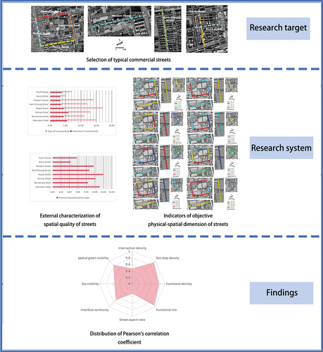
ABSTRACT
Chinese urban development has entered the stage of stock planning, and as an important part of urban public space, the construction of street space has a direct impact on urban development. High-quality street space contributes to sustainable urban development.High-quality street spaces are highly important for constructing vibrant and sustainable cities. Taking Jiaozuo city, a medium-sized city, as an example, this article establishes an evaluation index system for commercial street space quality from the aspects of external characterization and objective material space and uses the Pearson correlation coefficient to explore the influencing factors of urban commercial street space quality. This study finds that (1) crowd activities on commercial streets have different temporal and spatial patterns on weekdays and days off; (2) the external characterization of urban street space quality has a significant positive correlation with objective material spatial elements such as the density of public transportation stops, functional density, functional mixing, interface continuity, and spatial green visibility rate; (3) the enhancement of street accessibility and fine-tuning of functions are key to improving the spatial quality of commercial streets.This study provides theoretical basis and ideas for improving the spatial quality of commercial streets in medium-sized cities in China and promoting sustainable urban development.
GRAPHICAL ABSTRACT
1. Introduction
Since the country’s reform and opening up, with rapid economic development, China’s urbanization rate has risen by nearly 45 percentage points over the past four decades, and urban construction has made remarkable achievements. Rapid urbanization has also led to urban problems such as resource shortages, environmental deterioration, and traffic congestion (Yang et al. Citation2021). At present, China’s urban construction has changed from the original “incremental” to the “stock” stage, and improving the quality of public space has become a new requirement for high-quality urban development.
As the most commonly used urban public space, street space has both social and transportation attributes (Miura et al. Citation2023; Yoshihara et al. Citation2021). The transportation function of street space in China’s medium-sized cities is well developed, but the old urban areas generally have the problems of insufficient fine design of street space, uneven distribution of space use, lack of public facilities, and weakening of interaction space, which ignores the psychological needs and spiritual feelings of the citizens in the street space. Enhancing the vitality of streets and reshaping the quality of street space has become an important part of the sustainable development of medium-sized cities in China. At present, the research objects of street space are concentrated in megacities such as Beijing, Shanghai, Shenzhen, etc., and there is a lack of targeted research on medium-sized cities in China. This study complements the relevant research gaps by taking the medium-sized city of Jiao as an example.
Traditional research on urban public space is mostly based on qualitative research, and the technical means in the new data environment have promoted the quantitative and scientific development of urban public space research. Multi-source data has been applied to urban public space research by some scholars. The cooling effect of the park surrounding environment is proved by obtaining the relevant index data of 2D/3D landscapes around urban parks (Han, Xu, et al. Citation2023); the influencing factors of the cooling effect are determined by quantifying the internal spatial indexes of the urban parks (Cai et al. Citation2023); the influence mechanism of the 2D/3D urban landscapes on the diurnal surface temperatures is determined based on machine learning algorithms (Han, An, et al. Citation2023); constructed urban spatial morphology indicators from three dimensions of landscape pattern, architectural form and social development, and assessed the impact on surface temperature (Chen et al. Citation2023); used satellite data combined with land use to quantitatively measure and analyze the urban thermal environment differentiation law (Ren et al. Citation2023). This study utilized multi-source data such as POI, street photographs, and vector road network to enhance the scientificity and accuracy of the study.
This study aims to establish an evaluation index system for the spatial quality of commercial streets in medium-sized cities from the aspects of external representation and objective material space, obtain relevant multi-source data, and use Pearson correlation coefficients to explore the influencing factors of the spatial quality of urban commercial streets, and the results of the study can provide a new perspective for the measurement of spatial quality of the streets of the old urban areas in medium-sized cities of China in order to provide a new idea for the medium-sized cities to improve the spatial quality of the streets and reshape the vitality of the streets. The results of the study can provide a new perspective for measuring the spatial quality of streets in old urban areas of medium-sized cities in China, with a view to improving the spatial quality of streets and reshaping the vigor of streets in medium-sized cities.
2. A review of research on spatial quality of streets
The spatial quality of a street refers to the condition of the user’s perception of the objective physical spatial elements of the street (Tang and Long Citation2019). Measuring the spatial quality of streets is an important part of reshaping the spatial quality of streets. At present, domestic and foreign academic circles have not yet formed a unified definition of spatial quality. In the theoretical study of street spatial quality, foreign countries started early and developed quickly, went through the process of transforming the research object from macroscopic to microscopic, and formed a theoretical system from different perspectives. Kevin Lynch and others used the perspective of subjective perception to explore the cultural and spiritual value of space from the perspective of spatial attributes in urban imagery Yoshihara et al. Citation2021; Yoshinobu Ashihara advocated the beautification of streets and the strengthening of the social value of streets by following specific principles such as street height and width ratios in The Aesthetics of Streets from an aesthetic point of view Miura et al. Citation2023; Jane Jacobs introduced a user’s point of view and advocated the use of multidisciplinary street space to create diversified street spaces and emphasized the social value of streets from the point of view of the user in The Death and Life of America’s Big Cities. In “The Death and Life of America’s Great Cities”, Jane Jacobs, from a user’s perspective, advocated the use of a multidisciplinary approach to create diversified street spaces to reshape the vitality of the city (Chenghe Citation2018); Jan Geier, from a microperspective, advocated the construction of high-quality street spaces with a focus on the human scale, which is of positive significance in enhancing the social value of the space (Ashihara Citation2017); Jan Geier emphasized the wholeness and openness of streets (Jacobs and Hengshan Citation2005); Conzen School, based on the perspective of urban morphology, explored the town plane from a macro scale and proposed that streets are an important part of the town plane (Geier and He Renke Citation2003); Whyte paid attention to street life and believed that the fine design of streets can help to improve spatial quality (Geier Citation1971); Trancik proposed strengthening the continuity and integrity of street space through edge design and enhancing the vitality of the streets (Conzen Citation1960); and, based on the humanistic perspective, Montgomery emphasized the mixing of suitable urban texture, neighborhoods, water features and architectural styles as spatial imagery of streets (Whyte Citation1980). The theoretical research perspectives of street space have experienced a development process from macro to micro, and refined research theories can effectively guide the construction of street space.
In terms of street spatial quality, Chinese early qualitative research was dominated by qualitative research; for example, Xu Leiqing obtained questionnaire data through field research and explored the correlation between the street environment and the behavioral characteristics of pedestrians on West Nanjing Road in Shanghai (Trancik Citation1998). Subsequently, the continuous innovation of technological means has broadened the source of online data acquisition, and the application of big data such as POI and street view data has greatly enhanced the scientific and rigorous nature of quantitative research. Long Ying used Chengdu city as an example and cell phone signaling data to explore the degree of correlation between the external representations of different types of street vitality and their constituent elements (Montgomery Citation1998). Pei Yu used Dongcheng district of Beijing as an example and used streetscape data to explore the maintenance and use of street green space (Leiqing and Qi Citation2014). Di Di took downtown Shanghai as an example and used machine learning algorithms to construct a multidimensional street spatial quality measurement system, which provides technical support for refining street space. This study provides technical support for the refinement of street space (Ying and Yin). Lin Runze used the Gulou District of Fuzhou city as an example and used multisource data such as population heat and streetscape information to measure the qualitative and quantitative vitality of street space (Yu, Changcheng, and Anrong Citation2020). Yao Yuchao used the Hefei City Governmental Affairs District as an example and, based on multisource data, explored the correlation between the external characterization of street space vitality and the objective constituent elements (Di, Yinghong, and Dan Citation2021). Xuan Wei used the Qiguitang Neighborhood of Hefei city as an example and machine learning algorithms and spatial syntax to explore the relationship between street space vitality and objective constituent elements. Syntax to explore the correlation between spatial components of street space and behavioral characteristics (Runze, Cheng, and Ziling Citation2021). Based on the streetscape data, Fan Kaixuan explored the relationship between the landscape of street space and the vitality of the catering industry (Yuchao and Wei Citation2023). Lu Shiwei used the street management unit of the main urban area of Beijing as the basic unit of spatial analysis and revealed the correlation between street vitality and the elements of urban form based on the open data platform (Wei, Kang, and Chuanyun). Liu Sili analyzed the correlation status between the street vitality of neighborhoods and commercial business based on multisource data by taking the historical neighborhoods of Old Mendong in Nanjing as an example (Kaixuan et al. Citation2023). Wang Jinqiu explored the impact of large-scale linear sports activities on urban street vitality with the help of Baidu heatmap data (Shiwei, Jiawei, and Chaoyang Citation2023). Yang Liuqing analyzed the relationship between street vitality and the street greening level of Fuzhou city based on multisource data comprehensively by taking the street scope of the Third Ring Expressway in the main city of Fuzhou as the research object (Sili and Pengpeng Citation2023). The traditional qualitative research has the problems of strong subjectivity and lack of factual basis, etc. The quantitative research makes up for the shortcomings of the traditional research method, and greatly enhances the scientific and objective nature of the research results. China’s street space quantitative research has made great progress, but the current research object is concentrated in Beijing, Shanghai, Shenzhen and other megacities, and lack of research on medium-sized cities.
The construction of urban spatial evaluation system should be based on the characteristics of each type of space itself.There are more related studies by Subham Roy, who studied the spatial heterogeneity of urban household living conditions from the three dimensions of urban housing conditions, amenity levels and asset ownership (Roy et al. Citation2024), constructed the spatial evaluation index of urban vitality from six dimensions based on GWPCA (Roy, Majumder, et al. Citation2023), assessed the six dimensions of urban spatial heterogeneity of quality of life (Roy, Majumder, et al. Citation2023), constructed urban environmental quality evaluation indicators from three dimensions: ecological environment, landscape and built-up area, and socio-economic (Roy, Bose, et al. Citation2023), and also assessed urban flooding risk based on the integrated modeling approach of MCDA-GIS (Roy et al. Citation2021); Suranjan Majumder constructed social vulnerability evaluation indicators from three dimensions: exposure, sensitivity, and adaptive capacity (Majumder et al. Citation2023); Debanjan Basak assessed the perceived importance of sustainable city dimensions and the impact of performance on resident satisfaction and loyalty based on an integrated modeling approach of IPA-SEM (Bose et al. Citation2023). Street space mainly consists of four parts: transportation functional facilities, walking and activity space, ancillary functional facilities and building interfaces along the street, and the evaluation indexes of street space quality should fully take into account the components of objective physical space.
It can be seen that the research content of street space quality remodeling is constantly deepening and developing, and the overall presentation of the research perspective from macro to micro, and the research method from qualitative to quantitative characteristics. Currently, the research objects of street space are concentrated in mega-cities such as Beijing, Shanghai, Shenzhen, etc., and there is a lack of relevant research on medium-sized cities. There are 135 medium-sized cities in China, and 12 medium-sized cities such as Jiaozuo, Anyang and Pingdingshan are distributed in Henan, which is the province with the largest number of medium-sized cities in China. Among them, Jiaozuo is the only city in Henan province that overlaps the Zhengluo “double circle”, and it is also the regional center city in the border area of Henan and Jin, which is a typical representative of medium-sized cities in China. Therefore, Jiaozuo City is selected as the object of this study, and the evaluation indexes of the objective physical space of streets are selected from the three dimensions of accessibility, function, and interface, taking into account the constituent elements of street space.
3. Research design and indicator system construction
3.1. Objects of study
A commercial street refers to the street along the street used for retail, food, and other commercial activities, with a certain level of service capacity or industry characteristics (Shanghai Municipal Planning and Land Resources Administration, Shanghai MunicipalTransportation Commission, Shanghai Urban Planning and Design Institute Citation2016). Based on the definition of commercial streets and taking the Jiaozuo urban area as the research scope, the basis for selecting typical commercial streets is as follows:
Typical streets have continuous commercial development and are dominated by commercial businesses such as shopping and restaurants;
Typical streets have a certain level or range of services;
The spatial components of a typical street are diverse and different from each other.
After field research and screening, eight typical commercial streets were selected (); these streets can be categorized into two main road levels, two secondary road levels, two side road levels, and two cluster road levels according to the road level (, ).
Figure 1. Selection of typical commercial streets.
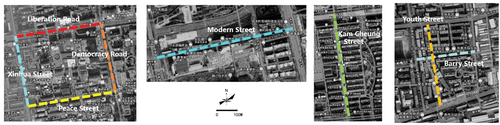
Table 1. Selection of typical commercial streets.
3.2. Research methodology
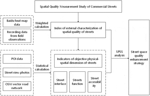
First, an evaluation system for commercial street spatial quality is constructed by combining offline and online data obtained from field research. Second, street spatial quality is analyzed based on acquired multisource data. Finally, SPSS is used to explore the specific elements affecting street spatial quality, and enhancement strategies for reshaping street spatial quality are proposed in combination with the analysis results().
Figure 2. Methodology flow chart.
3.3. Selection of indicators
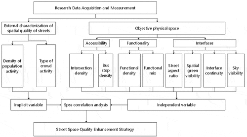
Based on multisource data, this study constructs an evaluation index system for street spatial quality from two dimensions: external characterization and objective physical space. The external characterization of street spatial quality includes two main indicators: crowd activity intensity and activity type. The intensity of crowd activity is obtained by continuously intercepting the Baidu heatmap of the target street and then subjectively scoring it, while the type of crowd activity is obtained by field observation of the target street, and its weight is determined by the coefficient of variation method.
Drawing on the index system of related studies and combining the components of commercial streets, this study selects the relevant indicators of the objective physical space of streets from three aspects: accessibility, function, and interface. Accessibility includes the density of street intersections and bus stops; function includes the density of street functions and the degree of functional mixing; and interface includes the street aspect ratio, the degree of continuity of the interface, the spatial green visibility rate and the sky visibility rate ().
Figure 3. Technology roadmap.
3.4. Data sources
The data sources used in this study are divided into two parts: field offline research and network online crawling. Field research obtained data on crowd activities, street intersections, bus stops, street interfaces, and network crawling information from street vector road networks, Baidu heatmaps, POIs, and street view photos.
Crowd Activity Data: Statistical data on the type of activity obtained by observing and recording the behavioral activities of pedestrians within the target streets in the field.
Street Interface Data: Field research on the number of intersections within the target streets and the number of transit stops within the 15-minute living area was performed, field measurements were taken, and the length, width, street elevation height, and continuous length of street elevation of the target streets were recorded to obtain street interface data.
Street Vector Road Network: Baidu road network data obtained from web crawling were processed in ArcGIS to obtain vectorized spatial location data.
Baidu Heatmap: This is a user usage mode of the Baidu map, which works on the principle that the Baidu background uses the positioning function of a cell phone base station to obtain the number of users in the target area and then renders the map color according to the different numbers of users. The Baidu heatmap can indicate the degree of user aggregation in a specific area of the city in real time, with darker colors indicating more aggregated users and lighter colors indicating fewer aggregated users. In this study, the Baidu heatmap of a target commercial street was intercepted every hour from 8:00 a.m. to 8:00 p.m. in a week with sunny weather and favorable temperatures in early October, and 728 valid screenshots were obtained. In this study, the Baidu heatmap was assigned heat values according to the color from light to dark and divided into a total of eight classes (1–8); each target street was segmented by 100 metermetres, and the average heat value of each street per 100 metermetres was calculated statistically.
POI Big Data: POI is the city of interest. In this study, a Gaode map was generated for all kinds of POI data acquisition. The data acquisition time was 2023. To ensure the accuracy and comprehensiveness of POI collection, according to the field research, this study used each street road centerline as a starting point and an outward broad 50 m as the boundary, crawling the POI data of each target street, for a total of 1,532 pieces of data. After screening, duplicate and address error point data were removed, and 1318 valid data points were retained ().
Table 2. Classification of POI data in Gaode Maps.
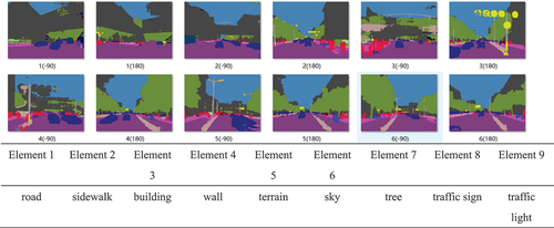
Street View Pictures: Street View Pictures are a map development platform through which information collection vehicles use a full range of road conditions around information and later processed by a development program to produce a three-dimensional effect. In this study, the crawling tool was used to crawl Baidu Street View pictures at 15 m intervals on the target street; the crawling angles were consistent, and the same street was crawled in the directions of -90° and 180°. In this study, a total of 456 observation points were set up, 912 street view pictures were crawled, and 86 pictures were manually taken on site so that the street view database needed for the study was obtained in batches. The acquired street scene images are processed by the semantic segmentation method to identify the pixel proportions of target features in the images and obtain the results of related index analysis ().
Figure 4. Street view image data processing.
3.5. Quantification of indicators
The spatial quality of the streets was quantified with basic data to facilitate the exploration of correlations among the streets via SPSS ().
Table 3. Index quantization table.
4. Results of street-spatial quality measurement
4.1. Quantification of extrinsic representations
4.1.1. Intensity of crowd activity
The statistics of this study revealed that on weekdays, pedestrians reach the highest heat value during the early stage of work, and then, most of the streets rise rapidly at 8:00 a.m. and begin to decline slowly at 9:00 a.m. After pedestrians leave work at noon, the street reaches the highest heat value during the day at midnight and then declines slowly. Additionally, pedestrians leave work in the afternoon for recreation, and the street begins to rise in heat value at 18:00 a.m. and ends at 20:00 a.m. On the day, pedestrians are more likely to go to shopping streets. On rest days, pedestrians tend to go to commercial streets for shopping and entertainment, so that the heat value of the street rises rapidly at 10:00 a.m. and then reaches the highest heat value of the day at 11:00 a.m. and then decreases briefly at 3:00 p.m. Then, it continues to rise at 5:00 p.m. until the end of the day at 8:00 p.m. The heat value of most of the streets on rest days is significantly greater than that on weekdays, and the average heat value of the remaining days is significantly greater than that The results show that the statistical results of the heat values of the target streets, the pattern of change, and the field research are consistent, and the data obtained have a certain degree of scientific validity and credibility.
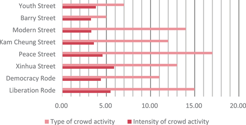
The Baidu heat data for weekdays and rest days were combined to calculate the combined average heat values of the target streets. The street heat value of Xinhua Street was the highest (5.87), the street heat value of Barry Street was the lowest (3.26), and the street heat values were ranked in descending order as follows: Xinhua Street > Liberation Road > Peace Street > Democracy Road > Youth Street > Kam Cheung Street > Modern Street > Barry Street ().
Figure 5. Crowd activity indications.
4.1.2. Type of crowd activity
High-quality street space attracts crowds for diverse activities. Jan Geier categorizes the activities of people in public spaces into necessary activities, spontaneous activities, and social activities. Necessary activities refer to the activities that residents carry out to maintain their daily lives, including going to work, going to school, eating, going to the clinic, getting a haircut, etc. Spontaneous activities refer to the activities that residents carry out of their sense of autonomy, including walking, strolling, relaxing, etc. Social activities refer to the activities that residents carry out in interaction with each other, including conversations, chess games, and children’s games.
In combination with field research and observation, the counting method was used to record crowd activities in the street space by type. The study showed that the section of Peace Street has the most types of crowd activities (17), while the section of Barry Street has the least types of crowd activities (5); the types of crowd activities ranked from the most to the least common are as follows: Peace Street > Liberation Road > Modern Street > Xinhua Street > Kam Cheung Street > Democracy Road >Youth Street >Barry Street ().
4.1.3. External characterization indices
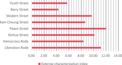
When characterizing the spatial quality of commercial streets, it is necessary to determine the proportion of the intensity of crowd activity and the type of crowd activity in the external characterization index to determine the specific value of the external characterization index. In this study, the coefficient of variation method is used to calculate the weights of each index according to the known data of each index, and the external characterization indices of street spatial quality are summed with the following formula: external characterization index = intensity of crowd activity × 0.40 + type of crowd activity × 0.60.
After calculation and processing, the study revealed that the three streets with the highest external representation indices were Peace Street, Liberation Road, and Xinhua Street, with specific values of 12.01, 11.18 and 10.14, respectively, and that the three streets with the lowest external representation indices were Democracy Road, Youth Street and Barry Street, with specific values of 8.34, 5.72 and 4.30, respectively(group road), with specific values of 8.34, 5.72, and 4.30, respectively, and the external characterization indices were ranked from high to low as follows: Peace Street > Liberation Road > Xinhua Street > Modern Street > Kam Cheung Street > Democracy Road > Youth Street > Barry Street ().
Figure 6. Quantitative map of the external representation.
4.2. Quantification of objective physical space evaluation indicators
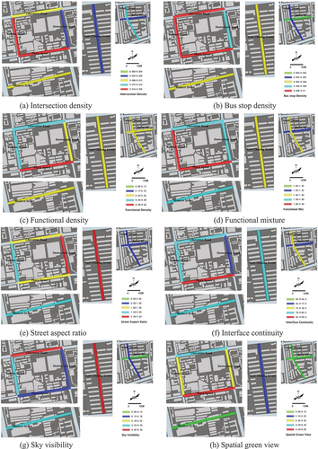
In this study, three level 1 indicators, namely, accessibility, function, and interface, are constructed for the objective physical space of the street. Accessibility includes two level 2 indicators, street intersection density and bus stop density. The function includes two level 2 indicators, street function density and degree of functional mixing. The interface includes four level 2 indicators, street width-to-height ratio, interface continuity, spatial green visibility, and sky visibility, and the data of the relevant indices are quantitatively analyzed.
In terms of accessibility, in terms of the density of street intersections, the highest values are distributed on Xinhua Street, Peace Street, and Barry Street, while the values of Democracy Road and Liberation Road are lower to minimize the interference of intersections with the capacity of the main roads. In terms of the density of bus stops, the highest values are distributed on the two main roads (Liberation Road and Democracy Road) and two secondary roads (Xinhua Street and Heping Street), while the values of Barry Street and Youth Street, as the grouping roads, are very low, and their values are lowest. In terms of bus stop density, higher values are distributed on two main roads (Liberation Road, Democracy Road) and two secondary roads (Xinhua Street, Peace Street).
In terms of functionality, as far as the functional density of the street is concerned, Xinhua Street, Peace Street, and Liberation Road are distributed on both sides of the street with a variety of types of commercial businesses, with high values, while a large number of stores exist in the area of Democracy Road with vacancies, and the commercial businesses on Barry Street and Youth Street are also mainly ground floor businesses serving the surrounding neighborhoods, with low values.
In terms of the interface, in terms of the interface aspect ratio, two main roads (Liberation Road and Democracy Road) and two secondary roads (Xinhua Street and Peace Street) are surrounded by multistory commercial buildings, with higher values, and two group roads (Barry Street and Youth Street) are surrounded by high-rise residential buildings, with lower values; in terms of interface continuity, the higher values are distributed in Xinhua Street, Peace Street, and Modern Street, and the lower values are distributed in Barry Street and Democracy Road; in terms of spatial green visibility, Jiaozuo has different greening standards for different levels of roads, with main roads>secondary roads>branch roads>group roads, the greening rate gradually decreases, among which the number of street trees on Peace Street, Liberation Road, and Xinhua Street increases, with higher values, and lower values occur in the areas of Youth Street and Barry Street. In terms of sky visibility, Liberation Road is flanked by multistory buildings, and a road width of 38 m allows pedestrians to have an open vision. Similarly, Kam Cheung Street on both sides of residential neighborhoods has a large building setback space, and the sky visibility rate of these two commercial streets is greater. Similarly, the width of the Barry Street road is narrow, and on both sides of multistory buildings, its sky visibility rate is lower ().
Figure 7. Quantitative map of objective material spatial indicators.
4.3. Analysis of the spatial correlation between the external representation and objective matter
Based on the results of the quantitative analysis of the external representations and objective physical space of the target streets, the Pearson correlation coefficient is used to investigate the interrelationship between the external representations and the objective physical space components. In this study, the correlation analysis is used to investigate the correlation between external representations and intersection density, bus stop density, functional density, functional mixture, street aspect ratio, interface continuity, sky visibility, and spatial green visibility, respectively:
The correlation coefficient between external representation and intersection density is 0.479, which is close to 0, and the p value is 0.229 > 0.05, thus indicating that there is no correlation between external representation and intersection density. The correlation coefficient between extrinsic representation and bus stop density is 0.946 and is significant at the 0.01 level, thus indicating that there is a significant positive relationship between external representation and bus stop density. The correlation coefficient between external representation and functional density was 0.832 and was significant at the 0.05 level, thus indicating a significant positive correlation between external representation and functional density. The functional setting of the street is the primary choice of the citizens for traveling (Zhang et al. Citation2022). The correlation coefficient between external representation and functional mixture was 0.962 and was significant at the 0.01 level, thus indicating a significant positive relationship between external representation and functional mixture. The correlation coefficient between the external characterization and street aspect ratio is 0.311, which is close to 0, and the p value is 0.453 > 0.05, thus indicating that there is no correlation between the external characterization and street aspect ratio.The street aspect ratio of underground commercial streets, on the other hand, significantly affects pedestrian activity in the space (Yao et al. Citation2021). The correlation coefficient between external representation and interface continuity is 0.723 and is significant at the 0.05 level, thus indicating a significant positive correlation between external representation and interface continuity. The correlation coefficient between external representation and sky visibility is 0.559, which is close to 0, and the p value is 0.150 > 0.05, thus indicating that there is no correlation between external representation and sky visibility. The correlation coefficient between external representation and spatial green visibility was 0.831 and was significant at the 0.05 level, thus indicating that there was a significant positive correlation between external representation and spatial green visibility.This is in line with the results of related studies, where greening helps to create an emotional atmosphere in the space, which is more attractive to citizens (Abusaada and Elshater Citation2021)(,,).
Figure 8. Pearson’s correlation coefficient statistics.
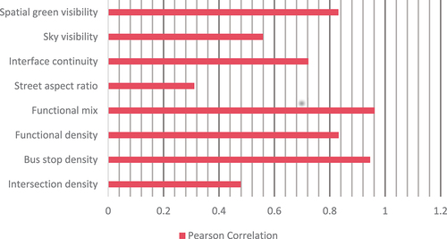
Figure 9. Distribution of Pearson’s correlation coefficient.
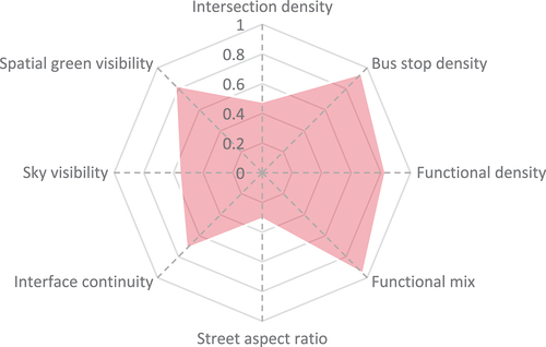
Table 4. The correlation between external representation and objective material space.
5. Discussion and conclusion
5.1. Discussion
5.1.1. Serious degradation of the spatial quality of commercial streets in medium-sized cities
High-quality street space is important for building a vibrant and sustainable medium-sized city. For this reason, in recent years, the government of Jiaozuo City has carried out many street quality improvement projects. For example, in 2017, Jiaozuo City launched a special rectification action for the facades of street-facing buildings; in 2019, Jiaozuo City’s urban management department pushed forward a special rectification and improvement of the cityscape. In the short term, Jiaozuo’s street environment has been greatly improved and has achieved stage-by-stage results, but it is still insufficient in the refinement of streets. The uneven distribution of commercial street space in medium-sized cities, the lack of public facilities, the shrinkage of interaction space, and the decline of spatial quality need to be solved.\
5.1.2. Spatial quality enhancement strategies for commercial streets in medium-sized cities
It was found that spatial green visibility, functional density and functional mix were significant influences on the external characterization of spatial quality, which is consistent with the results of related studies that the functional setting of the street is the primary choice that influences people’s mobility (Zhang et al. Citation2022), and that a good green space is also more appealing to the public (Abusaada and Elshater Citation2021). Unlike underground commercial streets, the width-to-height ratio does not affect the spatial quality to a significant extent (Yao et al. Citation2021). From the above conclusions, it can be seen that the density of bus stops, functional density, functional mixing degree, interface continuity and spatial green visibility of commercial streets are important factors to improve the spatial quality of streets in medium-sized cities. Therefore, we make the following recommendations. (1) Accessibility is the most important factor affecting the vitality of space (Mu et al. Citation2021), pay attention to the accessibility construction of medium-sized city streets and provide convenient urban public transportation for citizens to reach the street space quickly. Some scholars have studied the mutual adaptive relationship between urban public space and its surrounding public facilities, and the results prove that strengthening the construction of public transportation can effectively improve the quality of space (Huiqiu, Zhengwei, and Ran Citation2023). Since the road network of medium-sized cities is not yet perfect, it is necessary to improve the installation of public transportation such as bus stops around the streets, and convenient accessibility can help stimulate the improvement of spatial quality. (2) Promote the construction of high-quality street space by improving the mix of street functions. Some scholars have carried out research from the mutual influence relationship between public space and citizens’ life, which has proved that increasing the functional mix of public space can improve its quality (Zhu et al. Citation2020,). The higher the utilization rate of mixed functional areas, the higher the quality of urban space (Yue et al. Citation2016). In the future, medium-sized cities should pay attention to the rationalization of street space functions. A perfect functional business can enhance the attractiveness of street space for citizens, and because citizens’ travel is purposeful, a reasonable layout of functional business can also better guide and organize the activities of the crowd in the space. On the one hand, it is necessary to improve the functional density of street space, revitalize idle stores, and on the other hand, it is necessary to improve the functional mix of street space, meet the needs of the crowd through the composite functional forms, guide the crowd to orderly activities, and promote the formation of high-quality space. (3) Strengthening the street greening settings and design can enhance the pleasure of pedestrians (Gao and Xiang Citation2023) and effectively improve the quality of street space. Some scholars based on the theory of two-factor model of mental health, research has proved that street greening has a significant impact on promoting the mental health of pedestrians (Dong, Yu, and Xin Citation2021). Therefore, medium-sized cities should pay attention to the construction of the street environment, and use the facilities such as seats, trees, bonsai and other facilities to carry out refined design, enrich the street space level, and improve the quality of the street.
Jiaozuo City is a typical representative of medium-sized cities in China, and the results analyzed in this study can provide certain theoretical basis and ideas for the spatial quality improvement of commercial streets in other medium-sized cities. It is found that the density of bus stops, functional density, functional mixing degree, spatial green visibility and interface continuity are the significant influencing factors of the external characterization of spatial quality. In the spatial quality construction process of commercial streets in medium-sized cities, it is necessary to improve the density of bus stops within the 15-minute living circle of the streets, which can enable citizens to reach the bus stops faster to take public transportation, enhance the accessibility of the public transportation around the streets, and satisfy the travel needs of the citizens; it is necessary to improve the functional density and functional mixing degree of the streets, to enhance the functional richness and balance of the streets, and to better satisfy the needs of the citizens in terms of shopping, recreation, leisure, etc., and encourage more people to use the streets, It is necessary to improve the green visibility of street space, pay attention to the greening design of streets, provide citizens with good shade places and social spaces, and satisfy their needs for rest and interaction; it is necessary to reasonably improve the interface enclosure of streets, and make use of the arrangement of buildings, walls, fences, trees and other enclosing elements to enhance the sense of enclosure of the spatial interface of streets.
5.2. Conclusion
This paper selects Jiaozuo city as a typical object of medium-sized cities, establishes evaluation indexes of commercial street spatial quality from two aspects of external characterization and objective material space, and uses Pearson correlation coefficient to explore the influencing factors of urban commercial street spatial quality, and finds that: (1) From the viewpoint of comprehensive indexes of external characterization, the spatial quality of the eight streets in the order of from high to low is Peace Street > Liberation Road > Xinhua Street > Modern Street > Kam Cheung Street > Democracy Road > Youth Street > Barry Street. (2) Crowd activities in commercial streets have different spatial and temporal patterns of change on weekdays and rest days. (3) The spatial quality of urban streets has a significant positive correlation with objective material spatial elements such as bus stop density, functional density, functional mixture, interface continuity, and spatial green visibility rate. (4) Strengthening the spatial quality of streets is important in order to enhance the accessibility and functional refinement of streets. Accessibility and functional refinement settings is the key to improve the spatial quality of commercial streets.
This study provides theoretical basis and ideas for improving the spatial quality of commercial streets in medium-sized cities in China and promoting sustainable urban development. The commercial street spatial quality evaluation system constructed in this study only takes into account the objective material spatial dimension of the street, and can be further studied and analyzed in the future in multiple dimensions such as social, economic, etc.; the Baidu heat data obtained in this study is only for Baidu Maps cell phone users, and in the future, the sample size can be further expanded by using cell phone signaling related data to analyze the change rule of the users’ spatial and temporal changes in the street space within the smaller scope, and provide further references to improve and construct commercial street space quality of medium-sized cities in China. In the future, the sample can be further expanded by using mobile signaling related data in order to analyze the spatial and temporal changes of users in a smaller area of the street space, which will provide further references for the improvement of the spatial quality of commercial streets in medium cities.
Disclosure statement
No potential conflict of interest was reported by the author(s).
Additional information
Funding
Notes on contributors
Tongwen Wang
Tongwen Wang is an associate professor and master’s supervisor of Henan Polytechnic University. He is mainly engaged in regional and urban-rural development planning, landscape evaluation and planning, and tourism geography research.
Hongkai Li
Hongkai Li is a master‘s student of the School of Architecture and Art Design of Henan Polytechnic University. His main research direction is the protection of urban and rural historical and cultural heritage.
Xinmeng Cao
Xinmeng Cao is a master’s student in the School of Architecture and Art Design, Henan Polytechnic University. His main research direction is the protection of urban and rural historical and cultural heritage.
Chaohui Yue
Chaohui Yue is a master’s student in the School of Architecture and Art Design, Henan Polytechnic University. His main research direction is the protection of urban and rural historical and cultural heritage.
Yuanyuan Yang
Yuanyuan Yang is a master’s student at the School of Architecture and Art Design, Henan Polytechnic University. His main research interests are landscape architecture planning and design.
Weijie Huang
Weijie Huang is a master’s student in the School of Architecture and Art Design, Henan Polytechnic University. His main research direction is the theory of human thermal comfort.
Haidong Li
Haidong Li is an associate professor and master’s supervisor of Henan Polytechnic University. He is mainly engaged in the research, product design, development and evaluation of traditional villages, traditional houses and garden furniture.
References
- Abusaada, H., and A. Elshater. 2021. “Abeer Elshater, effect of People on Placemaking and Affective Atmospheres in City Streets.” Ain Shams Engineering Journal 12 (3): 3389–3403. https://doi.org/10.1016/j.asej.2021.04.019.
- Ashihara, Y. The aesthetics of the street (above) [M]. 2017. The Aesthetic Townscape, 36–60. Nanjing: Jiangsu Phoenix Literary Publishing House.
- Bose, A., D. Basak, S. Roy, I. R. Chowdhury, H. G. Abdo, M. Aldagheiri, and H. Almohamad. 2023. “Evaluation of Urban Sustainability Through Perceived Importance, Performance, Satisfaction and Loyalty: An Integrated IPA–SEM-Based Modelling Approach.” Sustainability 15 (12): 9788. https://doi.org/10.3390/su15129788.
- Cai, X., J. Yang, Y. Zhang, X. Xiao, and J. Xia. 2023. “Cooling Island Effect in Urban Parks from the Perspective of Internal Park Landscape.” Humanity and Social Sciences Communication 10 (1): 674. https://doi.org/10.1057/s41599-023-02209-5.
- Chenghe, G. 2018. “Urban form and Digital Urban Design.” The International Urban Planning 33 (1): 22–27+51. https://doi.org/10.22217/upi.2017.540.
- Chen, Y., J. Yang, W. Yu, J. Ren, X. Xiao, and J. C. Xia. 2023. “Xiangming Xiao, Jianhong Cecilia Xia, Relationship Between Urban Spatial Form and Seasonal Land Surface Temperature Under Different Grid Scales.” Sustainable Cities and Society 89 (104374). https://doi.org/10.1016/j.scs.2022.104374.
- Conzen, M. R. G. 1960. Alnwick, Northumberland: A Study in Town-Plan Analysis (Transactions and Papers (Institute of British Geographers), no. 27, 3–122. London: George Philip. https://doi.org/10.1177/0309132509334948.
- Di, D., J. Yinghong, and Y. Dan. 2021. “Comprehensive Evaluation of Urban Street Spatial Quality Under the Support of New Urban Science–A Case Study of Downtown Shanghai.” The Planner 37 (16): 5–12.
- Dong, L. Z. Yu, and D. Xin. 2021. “Effects of Perceived Characteristics of Living Street Environments on residents’ Mental Health: An Empirical Study in the Old City of Harbin.” Chinese Garden 37 (11): 45–50. https://doi.org/10.19775/j.cla.2021.11.0045.
- Gao, and D. H. Xiang. 2023. “A Study on the Association Between Green Visibility and Walking Pleasantness of Street Walking Space–An Empirical Comparison Based on Multiple Types of Streets in Wuhan.” Journal of Wester Habitat 38 (2): 52–59. https://doi.org/10.13791/j.cnki.hsfwest.20230208.
- Geier, J. 1971. `Buildings; using Public Space[m]. New York: Random House.
- Geier, J. He Renke, Translated by. 2003. Interaction and Space. 4th ed.) [ M]. Beijing: China Building Industry Press.
- Han, D., H. An, H. Cai, F. Wang, X. Xu, Z. Qiao, K. Jia, and Z. Sun. 2023. “Ying An, how Do 2D/3D Urban Landscapes Impact Diurnal Land Surface Temperature: Insights from Block Scale and Machine Learning Algorithms.” Sustainable Cities and Society 99 (104933). https://doi.org/10.1016/j.scs.2023.104933.
- Han, D., X. Xu, Z. Qiao, F. Wang, H. Cai, H. An, K. Jia, et al. 2023. “The Roles of Surrounding 2D/3D Landscapes in Park Cooling Effect: Analysis from Extreme Hot and Normal Weather Perspectives.” Building & Environment 231. https://doi.org/10.1016/j.buildenv.2023.110053.
- Huiqiu, S., T. Zhengwei, and P. Ran. 2023. “Research on the Mutual Adaptive Relationship Between Urban Public Space and Its Neighboring Public Facilities Based on CAS Theory–Taking Wuhan As an Example.” Modern Urban Research 4: 1–8+15. https://doi.org/10.3969/j.issn.1009-6000.2023.04.001.
- Jacobs, J. Jin Hengshan, Translated by. 2005. The Death and Life of America’s Great Cities [M], 25–26. Beijing: Yilin Publishing House.
- Kaixuan, F., L. Bin, X. Hanfa, M. Yuan, and W. Li. 2023. “A Study on the Relationship between Streetscape and Restaurant Vitality Based on Streetscape Data[j/OL].” Journal of South China Normal University (Natural Science Edition) 4:62–71. https://doi.org/10.6054/j.jscnun.2023050.
- Leiqing, X., and K. Qi. 2014. “Influence of Spatial and Interface Characteristics of Commercial Streets on the Staying Activities of Pedestrians–Taking West Nanjing Road in Shanghai As an Example.” Journal of Urban Planning: 03. https://doi.org/10.3969/j.issn.1000-3363.2014.03.013.
- Majumder, S., S. Roy, A. Bose, and I. R. Chowdhury. 2023. “Indrajit Roy Chowdhury, multiscale GIS Based-Model to Assess Urban Social Vulnerability and Associated Risk: Evidence from 146 Urban Centers of Eastern India.” Sustainable Cities and Society 96 (104692). https://doi.org/10.1016/j.scs.2023.104692.
- Miura, S., M. Yoshida, F. Nakamura, P. Wongwiriya, S. Tanaka, and R. Ariyoshi. 2023. “Spatial and Timeframe Distribution of Diverse Pedestrian Activities in the Street Network of Southeast Asian Developing Cities.” Journal of Asian Architecture andBuilding Engineering 23 (1): 386–404. https://doi.org/10.1080/13467581.2023.2220771.
- Montgomery, J. 1998. “Making a City: Urbanity, Vitality and Urban Design.” Journal of Urban Design 3 (1): 93–116. https://doi.org/10.1080/13574809808724418.
- Mu, B., C. Liu, T. Mu, X. Xu, G. Tian, Y. Zhang, and G. Kim. 2021. “Spatiotemporal Fluctuations in Urban Park Spatial Vitality Determined by On-Site Observation and Behavior Mapping: A Case Study of Three Parks in Zhengzhou City, China.” Urban Forestry and Urban Greening 64:127246. https://doi.org/10.1016/j.ufug.2021.127246.
- Ren, J., J. Yang, F. Wu, W. Sun, X. Xiao, and J. (. Xia. 2023. “Xiangming Xiao, Jianhong (Cecilia) Xia, Regional Thermal Environment Changes: Integration of Satellite Data and Land Use/Land Cover,iScience.” iScience 26 (2): 105820. https://doi.org/10.1016/j.isci.2022.105820.
- Roy, S., A. Bose, S. Majumder, I. Roy Chowdhury, H. Ghassan Abdo, H. Almohamad, and A. Abdullah Al Dughairi. 2023. “Evaluating Urban Environment Quality (UEQ) for Class-I Indian City: An Integrated RS-GIS Based Exploratory Spatial Analysis.” Geocarto International 38 (1): 1. https://doi.org/10.1080/10106049.2022.2153932.
- Roy, S., A. Bose, N. Singha, D. Basak, and I. R. Chowdhury. 2021. “Indrajit Roy Chowdhury, urban Waterlogging Risk As an Undervalued Environmental Challenge: An Integrated MCDA-GIS Based Modeling Approach.” Environmental Challenges 4:100194 ISSN 2667-0100. https://doi.org/10.1016/j.envc.2021.100194.
- Roy, S., S. Majumder, A. Bose, I. R. Chowdhury, and Indrajit Roy Chowdhury. 2023. “GWPCA-Based Spatial Analysis of Urban Vitality: A Comparative Assessment of Three High-altitude Himalayan Towns in India.” Journal of Spatial Science: 1–28. https://doi.org/10.1080/14498596.2023.2267011.
- Roy, S., S. Majumder, A. Bose, and I. R. Chowdhury. 2024. “Arghadeep Bose & Indrajit Roy Chowdhury (2024) Spatial Heterogeneity in the Urban Household Living Conditions: A-GIS-based Spatial Analysis.” Annals of GIS 30 (1): 81–104. https://doi.org/10.1080/19475683.2024.2304194.
- Roy, S., S. Majumder, A. Bose, I. Roy Chowdhury, and Indrajit Roy Chowdhury. 2023. “DoesGeographical Heterogeneity Influence Urban Quality of Life? A Case of a Densely Populated Indian City.” Papers in Applied Geography 9 (4): 395–424. https://doi.org/10.1080/23754931.2023.2225541.
- Runze, L., Z. Cheng, and W. Ziling. 2021. “A Study on Street Vitality and Beauty of Urban Center Area Based on Multi-Source Data–Taking Gulou District of Fuzhou City As an Example.” Journal of Nanjing Normal University (Natural Science Edition) 44 (3): 63–69.
- Shanghai Municipal Planning and Land Resources Administration, Shanghai MunicipalTransportation Commission, Shanghai Urban Planning and Design Institute, eds. 2016. Shanghai Street Design Guidelines [M]. Shanghai: Tongji University Press.
- Shiwei, L., Z. Jiawei, and S. Chaoyang. 2023. “Characteristics of Spatial Vitality Distribution and Analysis of Influencing Elements of Streets in Downtown Beijing During National Day Surveying and Mapping Geographic Information.” 48 (3): 100–104. https://doi.org/10.14188/j.2095-6045.2021235.
- Sili, L., and L. Pengpeng. 2023. Exploring the Correlation Between Street Vitality and Commercial Patterns in Historic Districts and Its Revelation–Taking the Old Mendong Historic District As an Example[j], 56–63. Vol. 1. Nanjing: Modern Urban Research. https://doi.org/10.3969/j.issn.1009-6000.2023.01.009.
- Tang, J., and Y. Long. 2019. “Measuring Visual Quality of Street Space and Its Temporal Variation: Methodology and Its Application in the Hutong Area in Beijing.” Landscape and Urban Planning 191 (103436). https://doi.org/10.1016/j.landurbplan.2018.09.015.
- Trancik, R. 1998. Finding Lost Space; Theories of Urban Design[m]. New York: John Wilet and Sons.
- W, H. Whyte. 1980. The Social Life of Small Urban Spaces[m]. Washington,D.C: Conservation Foundation.
- Wei, X., P. Kang, and Z. Chuanyun. 2023. “Research on the Association Mechanism of Street Space and Behavior Under New Data Environment.” Southern Architecture 2023 (4): 49–60. https://doi.org/10.3969/j.issn.1000-0232.2023.04.006.
- Yang, J., Y. Yang, D. Sun, C. Jin, and X. Xiao. 2021. “Influence of Urban Morphological Characteristics on Thermal Environment.” Sustainable Cities and Society 72 (103045): ISSN 2210–6707. https://doi.org/10.1016/j.scs.2021.103045.
- Yao, G., T. Yuan, Y. Rui, W. Chen, Z. Duan, L. Sun, X. Si, et al. 2021. “Research on the Scale of Pedestrian Space in Underground Shopping Streets Based on VR Experiment.” Journal of Asian Architecture and Building Engineering 20 (2): 138–153. https://doi.org/10.1080/13467581.2020.1782215.
- Ying, L., and Z. Yin. 2016. “Quantitative Evaluation of Street Vitality and Analysis of Influencing Factors–Taking Chengdu As an Example.” New Architecture 2016 (1): 52–57. h ttps://d oi.org/CNKI:SUN:XJZJ.0.2016-01-010.
- Yoshihara, T., T. Tanaka, S. Inachi, and H. Saito. 2021. “Factors Influencing Street Use Frequency and Evaluation of Street Image in Densely Built-Up Areas: A Case Study in Shinyo Neighborhood, Nagata Ward, Kobe.” Journal of Asian Architecture and Building Engineering 20 (5): 596–614. https://doi.org/10.1080/13467581.2020.1800475.
- Yu, P., K. Changcheng, and D. Anrong. 2020. “Research on the Assessment of Street Green Space Justice in the Dongcheng District of Beijing Based on Street View Map Data.” China Garden 36 (11): 51–56. https://doi.org/10.19775/j.cla.2020.11.0051.
- Yuchao, Y., and X. Wei. 2023. “Measurement of Spatial Vitality of Urban Streets from the Perspective of Multi-Source Data.” Journal of Nanjing Normal University (Natural Science Edition) 46 (1): 55–63.
- Yue, Y., Y. Zhuang, A.-G.-O. Yeh, J.-Y. Xie, C.-L. Ma, and Q.-Q. Li. 2016. “Measurements of POI-Based Mixed Use and Their Relationships with Neighbourhood Vibrancy.” International Journal of Geographical Information Science 31 (4): 658–675. https://doi.org/10.1080/13658816.2016.1220561.
- Zhang, Y., Y. Zou, Z. Zhu, X. Guo, and X. Feng. 2022. “Evaluating Pedestrian Environment Using DeepLab Models Based on Street Walkability in Small and Medium-Sized Cities: Case Study in Gaoping, China.” Sustainability 14 (22): 15472. https://doi.org/10.3390/su142215472.
- Zhu, J., H. Lu, T. Zheng, Y. Rong, C. Wang, W. Zhang, L. Tang, and L. Tang. 2020. “Vitality of Urban Parks and Its Influencing Factors from the Perspective of Recreational Service Supply, Demand, and Spatial Links.” International Journal of Environmental Research Public Health 17 (5): 1615. 17. https://doi.org/10.3390/ijerph17051615.