Abstract
This study quantitatively analyzed spatiotemporal changes in land use and landscape pattern in a coastal gulf region of southeast China by comparing classified satellite images from 1988, 2002, and 2007, using a geographic information system (GIS), remote sensing (RS), and landscape pattern metrics. The results show an increase in cropland, built-up area, and aquaculture area and a decrease in orchards, woodland, and beach area during 1988–2007. Over the study period, 64.3% of newly-expanded cropland was from woodland; newly-expanded built-up area of 34.8, 27.2, and 20.4% was converted from cropland, woodland, and beach areas, respectively; and newly-expanded aquaculture increased by 45.1 and 29.4% from beach and water body areas, respectively. Trend analysis of landscape pattern metrics demonstrates fragmentation of the landscape, with landscape pattern structure becoming more complex over the last two decades in the Louyuan Gulf region. Urbanization and policy developed to transfer beach/seawater areas into built-up area/aquaculture are the two main driving forces contributing to dynamic changes in land use and landscape pattern in the last two decades in Louyuan.
Introduction
Land-use and land cover change (LUCC) has received much attention due to its importance in global and regional environmental change (Turner et al. Citation1990; Liu et al. Citation2003). The spatial pattern of land use can reflect underlying human activities, including urbanization processes and policies for social and economic development at local to region scales (Redman Citation1999). Landscape pattern metrics are important for evaluating ecological processes and effects of LUCC (Wu Citation2000; Gautam et al. Citation2003). A large collection of indices has been developed to describe landscape pattern and these have proved useful for the description of landscape structure and its spatial–temporal dynamics (O'Neill et al. Citation1988; Turner Citation1989; Riitters et al. Citation1995). In recent years, the method of integrating landscape pattern metrics with geographic information systems (GIS) and remote sensing (RS) has been widely used to characterize land use/land cover and landscape pattern dynamics at watershed scale and in urban areas (Luck and Wu Citation2002; Gautam et al. Citation2003; Kong et al. Citation2005; Xie et al. Citation2006; Yu and Ng Citation2007).
As a developing but booming country, accelerated urbanization has taken place in many areas of China, and policies have been formulated to exert influence on land use and land cover change (Liu et al. Citation2003; Xie et al. Citation2006). Many regional studies on LUCC in China have been conducted on the relationship between human activities and spatio-temporal changes of land use and landscape patterns (Long and Li Citation2001; Xiao et al. Citation2006; Xie et al. Citation2006; Liu et al. Citation2007; Wang et al. Citation2007; Zhang et al. Citation2007; Zhang and Wang Citation2007). Currently, there are few reports on changes in coastal areas (Iverson and Prasad, Citation2007). Coastal areas, including gulf regions, are interaction areas between the land and the ocean, suffer from intense human activity (e.g. urbanization), and so become ecologically vulnerable. Human activities, including urbanization processes, are major driving forces that greatly modify the shape of a coastal area and its ecological environment (Townend Citation2002).
This study chose a typical coastal gulf region in southeast China, and quantitatively analyzed spatiotemporal changes of land use and landscape pattern from 1988 to 2007. As the sixth largest gulf in Fujian Province, Louyuan Gulf region faces double pressure in terms of sustainable development and environmental protection, together with accelerated urbanization. The objectives of this study are: (1) to explore characteristics of land-use dynamics and landscape pattern changes; and (2) to quantitatively describe the relationship between spatiotemporal changes of land use and landscape pattern and human activities in the Louyuan Gulf region in the last two decades.
Materials and methods
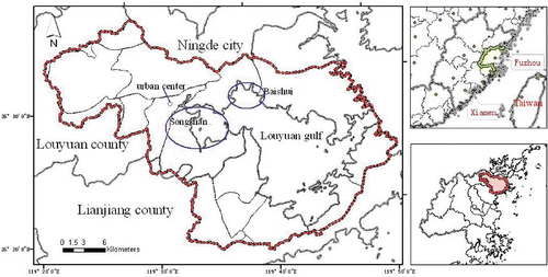
As the sixth largest gulf in Fujian, Louyuan Gulf covers about 860 km2, comprising Louyuan and Lianjiang counties, and is northeast of Fuzhou (119° 36′42″−119° 50′12″E, 26° 19′05″−26° 28′50″N) (). Louyuan Gulf is subtropical, with a typical monsoon climate, and annual precipitation of 1650 mm. The area is surrounded by mountains and hills, and has a mean elevation of 215 m. Most of the original vegetation has been destroyed by human activities, and pine trees are dominant.
Figure 1. Location of study region.
Data sources and processing
The main data used were Landsat Thematic Mapper satellite image from 1988, 2002, and 2007, and a SPOT satellite image for 2002. Subsets of satellite images including TM and SPOT were first rectified for inherent geometric errors using digital topographic maps in a modified universal transverse Mercator coordinate system. TM and SPOT images were first transferred into digital topographic maps using distinctive features, such as road intersections and stream confluences that are clearly visible in the images, and incorporated into the already revised images through image-to image registration techniques with rectification errors for pixels.
Unsupervised classification and manual on-screen digitizing and recoding methods were coupled for classification of all the images. Landsat data were separated into 30 classes using unsupervised classification techniques in ERDAS, and eight classes were further classified, namely, cropland, orchard, woodland, built-up land, beach, aquaculture, water body, and unused land. Based on primary results from unsupervised classification, land-use maps from on on-the-spot surveys in 1988, high resolution images (i.e. SPOT with pixel size of 2.5 × 2.5 m in 2002), and field surveys in 2007 were prepared to check and verify the results and to obtain the land use in Louyuan Gulf region in 1988, 2002, and 2007. Although no formal classification accuracy assessment or ground truth assessment was performed, the above classes were general and distinct enough to instill confidence in the classification (Iverson and Prasad Citation2007).
After selectively combining classes, classified images were sieved, clumped, and filtered before producing the final output. All activities were performed in Image ERDAS version 8.7 (Leica, USA). Classified images were then exported to ARCGIS version 9.0 (ESRI, Redlands, USA) and the rest of the analyses were performed in GIS environments. The images were first converted to grids in ARCGIS and then to shape formats. The resultant polygon themes were further transformed into raster themes with a cell size of 30 × 30 m.
Detection of land-use changes
The land-use polygon themes for 1988, 2002, and 2007, obtained from the digital classification of satellite data and subsequent GIS analyses using the method described above, were overlaid two at a time in ARCGIS, and the area converted from each of the classes to any of the other classes was computed, resulting in a land-use transformation matrix.
Landscape pattern changes
In order to explore landscape pattern changes, 11 landscape metrics were chosen for study: number of patches (NP), patch density (PD), class percentage of landscape (PLAND), largest patch index (LPI), mean patch size (MPS), landscape shape index (LSI), area-weighted mean patch fractal dimension (FRAC_AW), Shannon's diversity index (SHDI), contagion index (CONT), patch cohesion index (COHES), and splitting index (SPLIT). These landscape metrics were chosen on the basis of literature reviews and relevance to this research. These should have a direct influence on landscape pattern, ecosystem function, and habitat quality. The 11 landscape metrics were computed using the landscape pattern analysis package, FRAGSTATS (Version 3.3) at both the class and landscape level to quantify and examine spatio-temporal changes in landscape composition and landscape configuration for the whole gulf region (McGarigal and Marks Citation2002).
Results and discussion
Land-use dynamic change in Louyuan Gulf region
The land-use maps for 1988 and 2007 are presented in . shows the change in land-use structure in Louyuan Gulf region in 1988, 2002, and 2007. During 1988–2007, the area of cropland, built-up land, and aquaculture increased, whereas the area of orchards, woodland, and beach shrank. Water bodies decreased during 1988–2002 but increased for 2002–2007. For unused land, the tendency was in the opposite direction. Between 1988 and 2007, aquaculture and built-up were the two land-use types with the largest rate of increase, mainly due to the very low value in 1988. Population increase and economic growth in this region may be the two major causes for increases in built-up land area and construction area.
Table 1. Land-use structure change from 1988 to 2007 in Louyuan Gulf region
Figure 2. Land use map in Louyuan Gulf region in 1988, 2007.
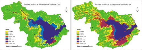
A land-use transfer matrix can find land-use changes for different periods. According to the land-use transfer matrix (), over the period 1988–2007, 64.3% of new cropland area was obtained from woodland. Among new built-up lands, 34.8, 27.2, and 20.4% were converted from cropland, woodland, and beach, respectively. In Louyuan Gulf region, mountains and hills occupy a large proportion of the land area, and plain areas suitable for construction are sparse, therefore, built-up land, including that for transportation and construction, can only come from conversion of woodland, cropland, and beaches. The policy formulated in 1992 to convert beach areas into construction land is surmised to be an important factor contributing to the increment of built-up land and aquaculture area (Committee for Compiling Louyuan County Annals Citation1998). The aquaculture area increased using 45.1% of beach and 29.4% of water body areas (). It is possible that some unused land, such as barren rocky areas, was misclassified as woodland, and that beach was misclassified as water body in different satellite images, leading to fluctuations in the unused land area, water body, and beach during the study period.
Table 2. Percentage of land use converted to specific land-use groups during 1988–2007
shows losses and gains among the major land-use groups over the study period. Among the major land-use classes, around 44.76% of cropland, 67.63% of woodland, 47.37% of built-up land, and 93.02% of beach remained unchanged in 2007. Cropland increased by about 72% during 1988–2007; built-up land lost 52.63% of its 1988 area to other classes and gained 615.6% from other classes, resulting a net increase of 54.28 km2; and 5.64% of beach remains unchanged largely due to the different times of satellite observations, but lost 94.36% to other classes and gained 12.47% from other classes.
Table 3. Overview of changes in major land-use groups from 1988 to 2007 in Louyuan Gulf region
Landscape pattern in Louyuan Gulf region
Based on the three periods of land use/land cover data (), FRAGSTAT3.3 software was further used to calculate landscape pattern metrics in 1988, 2002, and 2007 (). The spatio-temporal pattern of the landscape is quantitatively described in the following two sections at landscape and class levels.
Table 4. Landscape metrics at landscape level from 1988 to2007 in Louyuan Gulf region
Landscape metrics at landscape level
shows the change in landscape pattern metrics at landscape level between 1988 and 2007. The number of patches (NP) increased from 1364 in 1988 to 1686 in 2007. Patches density (PD) increased from 1.56 in 1988 to 1.96 in 2007, Shannon's diversity index (SHDI) increased from 1.27 in 1988 to 1.54 in 2007. The contagion index (CONT) reduced from 63.3% in 1988 to 54.12% in 2007, while the largest patch index (LPI) significantly decreased from 55.13 in 1988 to 15.97 in 2007. The increase in landscape pattern metrics during the study period underlies the fact that fragmentation of the landscape tended to strengthen, and spatial variability of the landscape increased in Louyuan Gulf region in the last two decades. Moreover, the landscape pattern structure became more complex, as discerned in the following landscape metric changes from 1988 to 2007: landscape shape index (LPI) increased from 31.1 in 1988 to 46.67 in 2007; and area-weighted mean fractal dimension index (FRAC_AW) showed a very slight increase in the first period (1988–2002) and a substantial increase in the second period (2002–2007). This indicates that shape complexity has become more irregular over time and fragmentation processes have strengthened. Human activities, including accelerated urbanization, can result in landscape pattern fragmentation and more complex landscape structure.
The patch cohesion index (COHES) showed a slight reduction from 1988 to 2007, which is largely related to unchanged main components in the landscape – woodland and water body – due to the mountainous and hilly topography and the gulf characteristics. In addition, SPLIT metrics substantially increased from 2.97 in 1988 to 12.57 in 2007, and the increase in the second period (2002–2007) was higher than in the first period (1988–2007), suggesting that ecological processes strengthened due to human disturbance in recent years.
Landscape metrics at class level
Louyuan Gulf region is dominated by woodland, water bodies, and cropland, which together accounted for 88.4, 81.4, and 80.0% in 1988, 2002 and 2007, respectively (). In contrast, built-up land area covered only 1.12% in 1988 and 7.42% in 2007. This indicates that the region was still dominated by agriculture, whereas urbanization rate was relatively slow and urban development was still in its initial stages.
Table 5. Landscape metrics at class level from 1988 to2007 in Louyuan Gulf region
PLAND of cropland increased from 12.6% in 1988 to 21.76% in 2007, and the increase in recent years (2002–2007) is higher than in the first period (1988–2007). This can be quantitatively described by the change in value of the pattern metrics NP, PD, LPI, LSI, and FRAC_AW; that is, these metrics increased during 1988–2002 but decreased during 2002–2007. In addition, mean patch size (MPS) and COHES of cropland tended to increase over the study period, suggesting that development of cropland stabilized after the first period (1988–2002).
PLAND of woodland decreased during 1988–2007, especially in the second period (2002–2007). LSI, MPS, and FRAC_AW increased during 1988–2002 but decreased during 2002–2007. NP, PD decreased during 1988–2002 but increased during 2002–2007, which reflects uncertainty. In total, the intensity of human activities, including converting woodland into cropland, was less in the first period (1988–2002) than that in the second period (2002–2007). LPI and COHES continuously shrank between 1988 and 2007, indicating fragmentation of woodland due to human activities, including conversion into cropland, built-up land, etc.
The increased PLAND, NP, PD, LSI, MPS, and LPI of the built-up area indicate increasing urbanization and aggregation with economic development. PLAND of built-up area increased from 1.12% in 1988 to 7.42% in 2007. The COHES value of build-up land increased from 91.6% in 1988 to 98.2% in 2007, indicating increased connectedness of built-up area patches. With the process of urbanization, this may be due to aggregation of the rural residential area, industrial developed area, and urban area into a small area of clumped built-up land patches.
There was a drastic change in aquaculture area. PLAND of aquaculture increased significantly from 0.95% in 1988 to 9.46%; NP, PD, LPI, LSI, and COHES also increased over the study period, and MPS decreased. Aquaculture in beach and sea areas accompanied economic development and population growth.
In conclusion, changes in land-use structure between 1988 and 2007 were distinctive in the landscape metrics analysis, although urbanization was not rapid. The aquaculture landscape patch drastically increased from 1988 and 2007; correspondingly, the water area shrank. Over the study period, the drastic decrease in PLAND, LPI, and PD of woodland, beach, and water, and increasing PLAND, PD, NP, LPI, and MPS of cultivated land and aquaculture can be explained by land transformation and fragmentation of landscapes.
Conclusions
Landscape pattern metrics integrated with GIS and RS were used to quantitatively analyze the spatio-temporal changes of land use and landscape pattern in a coastal region of southeast China. Three years of Landsat Thematic Mapper (TM) images (1988, 2002 and 2007) were interpreted to obtain land-use datasets. According to the land-use transformation matrix using ERDAS and ARCGIS software, the area of cropland, built-up land, and aquaculture increased, whereas the area of orchard, woodland, and beach shrank. There was an increase in cropland of 64.3% from woodland, built-up area increased by 34.8% from cropland, 27.2% from woodland, and 20.4% from beach. Aquaculture area increased by 45.1% from beach and 29.4% from water bodies. Overall trend analysis of landscape pattern metrics shows landscape fragmentation processes were strengthened and landscape pattern structure increased in complexity in the last two decades. Urbanization and the policy developed to transfer beach/seawater into built-up land/aquaculture are the driving forces contributing to the dynamic changes of land use and landscape pattern in the last two decades in Louyuan region.
Acknowledgements
The authors acknowledge financial support from the Department of Science & Technology of Fujian Province for Talented Youth Scholars of Fujian Province (No. 2007F3093).
Related Research Data
References
- Committee for Compiling Louyuan County Annals . 1998 . “ County annals of Louyuan County ” . Beijing : Fangzhi press . in Chinese
- Gautam , AP , Webb , EL , Shivakoti , GP and Zoebisch , MA . 2003 . Land use dynamics and landscape change pattern in a mountain watershed in Nepal . Agric Ecosyst Environ. , 99 : 83 – 96 .
- Iverson , LR and Prasad , AM . 2007 . Using landscape analysis to assess and model tsunami damage in Aceh province, Sumatra . Landsc Ecol. , 22 : 323 – 331 .
- Kong , F , Nobukazu , N , Yin , H and Kikuchi , A . 2005 . Spatial gradient analysis of urban green spaces combined with landscape metrics in Jinan city of China . Chin Geogr Sci. , 15 ( 3 ) : 245 – 261 .
- Liu , J , Gao , J , Geng , B and Wu , L . 2007 . Study on the dynamic change of land use and landscape pattern in the farming–pastoral region of northern China . Res Environ Sci. , 20 ( 5 ) : 148 – 154 . in Chinese
- Liu , J , Liu , M , Zhuang , D , Zhang , Z and Deng , X . 2003 . Study on spatial patterns of land-use change in China during 1995—2000 . Sci China (Ser D). , 46 ( 4 ) : 373 – 384 .
- Long , H and Li , X . 2001 . Land-use pattern in a transect of the Yangtse River and its influening factors . Acta Geogr Sin. , 56 ( 4 ) : 417 – 425 . in Chinese
- Luck , M and Wu , J . 2002 . A gradient analysis of urban landscape pattern: a case study from the Phoenix metropolitan region, Arizona, USA . Landsc Ecol. , 17 : 327 – 339 .
- McGarigal , K and Marks , BJ . 2002 . “ FRAGSTAT: spatial pattern analysis program for quantifying landscape structure ” . In Gen. Tech. Rep. PNW-GTR-351. Pacific Northwest Research Station, USDA-Forest Service Portland, Oregon, USA
- O'Neill , RV , Krummel , JR , Gardner , RH , Sugihara , G , Jackson , B , DeAngelis , DL , Milne , BT , Turner , MG , Zygmunt , B Christense , SW . 1988 . Indices of landscape pattern . Landsc Ecol. , 1 : 153 – 162 .
- Redman , CL . 1999 . Human dimensions of ecosystem studies . Ecolo-systems. , 2 : 516 – 526 .
- Riitters , KH , O'Neill , RV , Hunsaker , CT , Wickham , JD , Yankee , DH , Timmins , SP , Jones , SP and Jackson , BL . 1995 . A factor analysis of landscpae pattern and stucture metrics . Landsc Ecol. , 10 : 23 – 39 .
- Townend , I . 2002 . Marine science for strategic planning and management: the requirement for estuaries . Mar Policy. , 26 ( 3 ) : 209 – 219 .
- Turner , BL , Clark , WC , Kates , RW , Richard , JF , Mathews , JT and Meyer , WB . 1990 . “ The Earth as transformed by human action ” . In Global and regional changes in the biosphere over the past 300 years , Cambridge, New York : Cambridge University Press (with Clark University) .
- Turner , MG . 1989 . Landscape ecology: the effect of pattern on process . Ann Rev Ecol Syst. , 20 : 171 – 197 .
- Wang , X , Wang , Q , Li , H and Liu , G . 2007 . Driving forces of land-use change/cover in the Yellow River delta . Resour Sci. , 29 ( 5 ) : 175 – 181 .
- Wu , J . 2000 . Landscape ecology—pattern, process, scale and hierarchy , Beijing : Higher Education Press .
- Xiao , J , Shen , Y , Ge , J , Tateishi , R , Tang , C , Liang , Y and Huang , Z . 2006 . Evaluating urban expansion and land use change in Shijiazhuang, China, using GIS and remote sensing . Landsc Urban Plan. , 75 : 69 – 80 .
- Xie , Y , Yu , M , Bai , Y and Xing , X . 2006 . Ecological analysis of an emerging urban landscape pattern—desakota: a case study in Suzhou, China . Landsc Ecol. , 21 : 1297 – 1309 .
- Yu , XJ and Ng , CN . 2007 . Spatial and temporal dynamics of urban sprawl along two urban–rural transects: a case study of Guangzhou, China . Landsc Urban Plan. , 79 : 96 – 109 .
- Zhang , G , Deng , W , Lu , X , Song , K , Li , H and Zhang , H . 2007 . The dynamic change of wetland landscape patterns in Xinkai River basin . J Nat Resour. , 22 ( 3 ) : 204 – 210 . in Chinese
- Zhang , H and Wang , X . 2007 . Land-use dynamics and flood risk in the hinterland of the Pearl River Delta: the case of Foshan City . Int J Sus Dev World Ecol. , 14 : 485 – 492 .