
ABSTRACT
This paper proposes the concepts and associated contents of landsenses ecology and mix-marching data, and explains the roles of the meliorization model and Internet of Things (IoT) in the landsenses ecology-based land-use planning, construction and management. It also analyses the importance and application approaches of mix-marching data. In the current situation of rapid social-economic, scientific, and technological development, there exists an urgent need for us to further study landsenses ecology and its applications.
1. Landsenses ecology
In the process of human civilization, our predecessors continually engaged in land-use planning and associated constructions, with educational significance for us and for our future generations.
Along with the advancement of human civilization, people began to consciously make their land-use plans on the basis of their understanding of nature and their own needs. In accordance with these plans, they developed and constructed their communities to improve life and increase production.
Later, with the expansion of people’s needs and the emergence and formation of different disciplines, especially with the progress of communication and transportation, many different approaches to land-use planning were proposed, and the scales of temporal–spatial accessibility of these plans were expanded. Landscape ecology is one representative of these disciplines, which has played an important role in land-use planning and urban construction (Wu Citation2006, Citation2013).
As society reaches ever higher levels of socio-economic development, and modern science and technology progresses rapidly, people’s cognitive ability, ideas, and needs dramatically change or expand and require innovative methods of analysis. Accordingly, new ideas are proposed for directions and contents of regional development, which result in expansions of theory, methods, and contents for landscape ecology, or can lead to the development of new approaches to landscape ecology. One new approach can be described as landsenses ecology, or 景感生态学 in Chinese.
From our current understanding, we define landsenses ecology as a scientific discipline that studies land-use planning, construction, and management toward sustainable development, based on ecological principles and the analysis framework of natural elements, physical senses, psychological perceptions, socio-economic perspectives, process-risk, and associated aspects. The natural elements include light, temperature, water, soil, geomagnetism, radioactivity, topography and morphology, etc. The senses of sight, smell, hearing, taste, light, and touch (e.g., wind speed, wind direction, temperature, humidity, etc.) belong to the category of physical senses. Psychological perceptions include some elements of religion, culture, vision, metaphor, security, community relations, well-being, etc. For the convenience of research and applications, some of the elements can be placed into more than one of the above three broad categories. The presence or absence and the different combinations of these elements will have different land-use effects.
Ancient Chinese urban planning and architectures exhibit, to some extent, the rudiment of landsenses ecology. Wind, as both a necessary natural and an important cultural element, had a significant role in ancient urban planning, where wind was viewed as a kind of field, similar to the modern concept of a wind field. People hoped to live in a relatively appropriate wind environment, embedded in a cultural and spiritual context. In ancient Chinese urban planning and architectural design, natural elements were considered and analyzed, and at the same time the elements of Chinese traditional culture and people’s vision or desires were integrated into urban planning and architectural design.
This kind of planning and design involved adaption and/or improvement in the natural environment to suit human life, and to constantly remind and warn people to regulate and normalize their own behaviors in accordance with this vision. Such reminders and warnings might also promote the formation of people’s behavioral norms, which could lead people to develop a sense of community, foster an atmosphere of harmony, and eventually achieve the ideal state of ‘do as you would be done by’. The philosophy of integrating ‘heaven, earth and man’, or ‘humans, architecture and the natural environment’, encapsulates the simple germination of sustainable development at that time.
In fact, landsenses ecology emerged naturally during the process of theoretical research and practice, inspired by a variety of traditional thoughts on planning and architecture.
2. Meliorization model
Landscape ecology is mainly derived from, and naturally serves as the basis for, land-use planning and construction.
The objectives of land-use planning and construction are to sustainably use local land and related resources to constantly improve and enhance local people’s quality of life, and promote and ensure the aim of local sustainable development.
Land-use planning and construction are also one of the most important aspects of the construction of ecological civilizations, and their aim is also consistent with the construction of an ecological civilization. Ecological civilization is a civilization pattern that can provide and ensure sustainable welfare for people while maintaining and improving ecosystem services (Zhao Citation2013). Obviously, ecological civilization is a form of civilization toward sustainable development.
The planning, construction, and management of land uses involves various aspects, and is a process of long-term, continuous and integrated feedback and improvement, during which some unexpected situations and changes may appear. Landsenses ecology-based land-use planning, construction, and management will be especially complicated. A plan cannot be perfected through one or two stages, as it is a process of advancement-feedback-improvement, that is, a process of meliorization.
Chinese cursive calligraphy is a typical process of meliorization. The writing process needs to consider both the writing of every character and the connection and layout of the characters, which will – both in detail and as a whole – display and exaggerate the connotation of the calligraphic work and writer’s emotion. In every step of this process, there will be not only infinite choices, but also unexpected situations due to brush, ink, paper, hand control, and associated factors.
The effective assessment of land-use planning and construction is a key step in land-use management. The key point of land-use planning and construction is not a problem of optimization, because the constraints and objectives are often intertwined, so it is appropriate to adopt the meliorization model (Zhao Citation1992, Citation2013).
The core idea of the meliorization model is the belief that there exist only better approaches, rather than a best result. The meliorization model is penetrated with the essence of optimization models. By intertwining constraints and objectives, the meliorization model aims to improve step-by-step, rather than optimizing, the objectives by the coordination and regulation of processes involved.
3. Mix-marching data
The concept of landsenses ecology shows that it is directly or indirectly involved in the data needed to characterize the natural, economic, social, psychological, prospective, process, risk, and associated aspects for its application.
In fact, the process of scientific and technological development indicates that the concept of ‘data’ has been constantly changing and developing and its connotation is continually being enriched and expanded.
The meliorization model requires the support of two categories of data: mixing data and marching data.
Mixing data refers to all forms of data having the same or different properties, obtained in different ways, from different sources, temporal-spatial scales, and other available approaches. It includes experimental data, observation data, monitoring data, derived data, remote sensing data, statistical data, experiential data, alternative data, questionnaire survey data and psychological data, etc. The data from remote sensing and image interpretation are often interpreted differently when viewed by different interpreters. There are often significant differences between data within the same scheme but collected at different times, at different locations, and from different people. Therefore such data need to be adjusted when they are used in applications.
Marching data refers to the data obtained during the implementation of working procedures, which were not known before the implementation of working procedures. In practice, people sometimes adopt simulation or prediction data for their exploratory researches and risk analyses.
For the convenience of analysis, the integration of these two types of data is referred to as mix-marching data. The significance of the concept of mix-marching data is that some complex research and practices can only be effectively carried out after obtaining support from such data sources.
According to the traditional concept, these data cannot be regularly used by a traditional analysis method. The influence of the ‘defective’ data on analysis results should be known beforehand, if a traditional analysis method has to be adopted.
4. IoT/ZeroIoT – an indispensable approach
The theoretical analysis and practical application of landsenses ecology require long-term, real-time, and in-situ observations of ecological and associated dynamic processes, including both objective and subjective senses. These kinds of observations could be obtained only by the Internet of Things (IoT), and cannot be obtained through other approaches.
At the same time, IoT provides an effective approach for the operations of meliorization and modeling, and provides further effective support for land-use planning, construction, evaluation, management, and regulation.
The development of IoT itself is a process of constantly moving forward. Along with the development of science and technology, the concept of IoT will continue to be transformed, and its connotation, extension, and practical applications will be continuously enriched and expanded. Future representations of the Internet and IoT may be very different from their current forms, or may be completely replaced by thoroughly new forms. This is an inevitable tendency. Keeping this idea may promote the better and faster development of IoT in the right direction.
It is envisaged that the ultimate form of IoT in the future could be something like a ZeroSpace Interconnection of Things (ZeroIoT, or ZeroSIT), which will be able to realize the collection, transportation, treatment, modeling, forecasting, early warning, and application of information in the shortest possible time, smallest possible space, with the smallest possible error and lowest possible insecurity. In the notion of a ZeroIoT, the zero space means that the time interval and the space interval in its whole operational process are all approaching zero, and at the same time the error and insecurity are also approaching zero. In short, the zero implies that ZeroIoT will be convenient and efficacious anytime and anywhere (Zhao et al. Citation2013). ZeroIoT is therefore the development direction for the IoT in the future, where IoT is the current form of ZeroIoT.
5. Framework for landsenses planning, construction, and management
Ecological planning is one of the important bases and elements in the land-use planning system. Landsenses ecological planning, or landsenses planning for short, is a form of planning that should promote and ensure local sustainable development with landsenses ecology as its main theoretical basis, with an ecological approach as its main method of restoration and construction, and with the integrated consideration of local natural conditions and people’s livelihoods, production, culture, and associated features.
With the integration of above analysis on landsenses ecology, meliorization model, mix-marching data, and IoT, a framework for landsenses planning, construction, and management is obtained as .
Figure 1. Framework for landsenses planning, construction, and management.
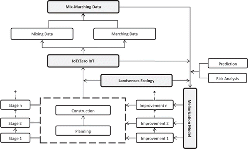
In , some items belong same category in attribute, but they are separated for the convenience to reveal and explain the relationships in the analysis framework. In application, this framework can be amended according to the practical conditions.
6. Ecological planning for the Xianghe Segment of China’s Grand Canal
China’s Grand Canal once consisted of the Sui-Tang Grand Canal, the Beijing–Hangzhou Grand Canal and the Eastern Zhejiang Grand Canal. This was started in 486 BC and completed during the Sui Dynasty (AD 581–618) and had a total length of 2700 km. Nowadays, the Grand Canal often refers to the Beijing–Hangzhou Grand Canal, as the Sui-Tang Grand Canal and the Eastern Zhejiang Grand Canal have been almost completely lost.
Here, the Grand Canal refers to the Beijing–Hangzhou Grand Canal, which was included in the World Cultural Heritage List in 2014. The canal starts in Beijing, passes through the provinces of Beijing, Tianjin, Shandong, Jiangsu, and Zhejiang, and ends at Hangzhou City, with a total length of 1794 km (). It also links the Haihe River, Yellow River, Huai River, Yangtze River, and Qiantang River.
Figure 2. The location of China’s Grand Canal.
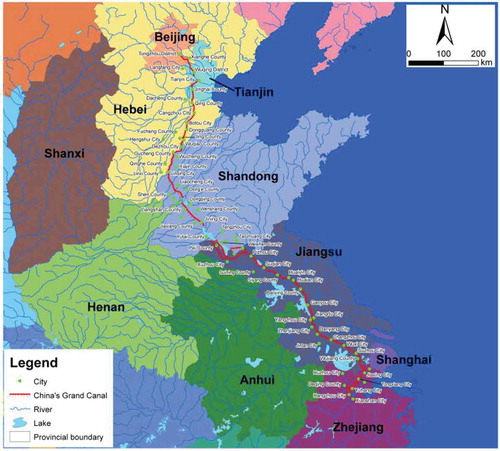
The Grand Canal was the north–south traffic artery of ancient China, and had a very important historical role. It promoted an increase in traffic movements, the exchange of people and the transportation of goods and material, and furthermore promoted urban development, economic prosperity, cultural integration, and the national unity of ancient China.
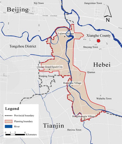
In this special issue, the Xianghe Segment of China’s Grand Canal (XSCGC) refers to the segment of the Grand Canal in Xianghe County, Hebei Province, which is 20.38-km long. The planning area is distributed on both sides of the XSCGC, and covers an area of about 62.99 km2 ().
Figure 3. The location of the planning area.
The planning system for XSCGC includes a general plan and some associated special plans. The ecological plan for XSCGC is one of the special plans and plays a fundamental, restraining, and leading role in the overall planning system. The ecological planning for XSCGC is mainly based on the framework of landsenses planning.
To effectively promote the necessary related works, a demonstration project for ecological planning in XSCGC was carried out. This ecological planning, that is, landsenses planning, mainly integrates landsenses ecology, meliorization model, mix-marching data, the IoT, and associated subjects to support the planning system. This special issue presents the main contents and results related to the ecological planning studies.
Disclosure statement
No potential conflict of interest was reported by the authors.
Additional information
Funding
Related Research Data
References
- Wu JG. 2006. Landscape ecology, cross-disciplinarity, and sustainability science. Landsc Ecol. 21:1–4.
- Wu JG. 2013. Landscape sustainability science: ecosystem services and human well-being in changing landscapes. Landsc Ecol. 28:999–1023.
- Zhao J. 1992. Theoretical pattern and its melioration model of sustainable use of resources - sustainable development of human society. In: China’s First Youth Academic Symposium; Beijing: China Science & Technology Press; p. 579–583 (in Chinese).
- Zhao J. 2013. Theoretical considerations on ecological civilization development and assessment. Acta Ecologica Sinica. 33:4552–4555 (in Chinese).
- Zhao J, Zheng X, Dong R, Shao GF. 2013. The planning, construction and management towards sustainable cities in China needs the Environmental Internet of Things. Int J Sustainable Dev World Ecol. 20:195–198.