
ABSTRACT
The sustainable development agenda 2030 calls for achievement of certain targets to ensure access to water and sanitation for all. Multi-stakeholder partnerships and the use of data and modelling tools are conditioning elements for their achievement. In this article, we demonstrate that participatory modelling supports informed and participatory decision making in complex river basins. An adapted companion modelling approach is presented to support collective action by reducing disputes and enhancing collaboration among stakeholders. The co-development and use of empirical models for understanding the complexity of the physical system is combined with the use of role-playing games to ensure the active involvement of stakeholders. The approach is implemented in a top-down water quality planning process in Turkey. Results show its suitability for managing water quality in complex river basins in an inclusive manner and its substantial benefits in developing stakeholders’ capacities and creating a cooperative environment.
1. Introduction
Fresh water is a finite and vulnerable resource. It is essential to sustain life, development and environment (GWP Citation2000). However, just having access to water and sanitation is not sufficient for sustaining life and development for all. Water quality is also an essential part for development (United Nations Citation2016). To deal with the complexity involved in water management, including the water quality aspects, the United Nations has included a specific target in the Sustainable Development Goals (SDG 6, target 5) specifying to implement Integrated Water Resources Management (IWRM) at all levels. However, lessons learnt from the past show that the implementation of IWRM encounters difficulties if most stakeholders still follow traditional planning mechanisms. Lack of knowledge about the water resources system, disagreements between water users and insufficient focus on operationalization are frequently causes of limited acceptance and practical implementation of IWRM plans (Biswas Citation2004). The three pillars of IWRM – (i) an enabling environment, (ii) an institutional framework, and (iii) management instruments – are key conditioning factors for the needed transformation. In many cases the proper enabling conditions are not in place. The approval of the SDGs and corresponding targets by all Member States of the United Nations shows the willingness of all countries to implement such a change.
In this article, participatory modelling is proposed as an appropriate solution for addressing complex medium and large river basin systems. The basins addressed in this article are characterized by a poor water quality status, high urbanization rates, data scarcity, complex institutional setups, power asymmetries between agencies and stakeholders, and reluctance to engage local stakeholders. The approach builds upon the lessons learned from developing and applying traditional Decision Support Systems and responds to the increased demand for integrating the knowledge from decision makers and stakeholders in the quantitative analysis of complex systems, often using modelling tools. In essence, participatory modelling differs from traditional modelling approaches by involving stakeholders in its modelling choices (e.g. variables, data, calibration, assumptions, scenarios or alternatives). These do not remain firmly the domain of expert modellers anymore. Instead, decision makers and stakeholders are involved in several stages of the planning process.
Numerous participatory modelling approaches and (qualitative and quantitative) tools were developed in the last decades by the scientific community (Voinov and Bousquet Citation2010; Basco-Carrera, Warren, van Beek, Jonoski, & Giardino, Citation2017). However, little information is available on participatory modelling methods and tools being designed and used in formal informed planning and management processes. Such processes require the use of empirical models for understanding the complexity of the physical system. In this article we argue that participatory modelling approaches and tools can be adapted, maintaining their key features and elements, so they can have a broader applicability. We first make an exploration of the key features of companion modelling (ComMod), under the umbrella of participatory modelling. We demonstrate the suitability of using an adapted approach to complex river basins that combines the key features of companion and empirical modelling and takes into account the differences in the institutional setup, scale of action, stakeholders involved and modelling tools. The description and comparison of both approaches is presented in Section 2. A top-down water quality planning case in Turkey was used to test the applicability of the adapted ComMod approach (Section 3). The article finalizes with an evaluation and lessons learnt from the design and application of the approach.
2. Methodology
2.1. Origins of commod
ComMod is a sub-type of participatory modelling that emerged in France in 1996 from the joint efforts of a group of researchers working in the fields of ecosystems and social systems. The approach is best suited for semi-structured problems (i.e. ‘stakeholder-oriented’ problems), commonly in small watersheds, characterized by disputes (caused by differences in viewpoints and objectives) among stakeholders. With the co-design and use of ‘simple’ role-playing games and agent-based models, ComMod aims to structure and elicit the different local practices, knowledge and experiences on the key elements of a system, as well as possible solutions and objectives to be achieved. For this, the approach promotes simple and double loops of individual and collective learning. Repetitive back and forth steps between the conceptual model and the field situation characterize the ComMod process.
ComMod relies on sharing knowledge to advance relationships among individuals, and between individuals and the resources (socio-ecological systems) (CIRAD Citation2004; Étienne Citation2013). This process has the objective to generate collective reflection and help resolving existing disputes among stakeholders. Commodians (referring to individuals specialized in ComMod processes (Olivier Barreteau et al. Citation2014)) and scientists/researchers are used as neutral parties to support the negotiation process. The modelling process is used to catalyse the interactions between the researchers and stakeholders. ComMod is therefore mainly used at the early stages of planning processes, where the main focus is to create a joint vision by alleviating tensions among stakeholders. Ultimately, the ComMod process leads to collective action (CIRAD Citation2004).
2.2. Why a new approach
An adapted ComMod approach is required to support the management of complex river basins characterized for:
Poor water availability and quality status in the basin (limited scientific knowledge);
Medium and large river basins;
Strategic urban development areas;
High urbanization rates, and high inequality between rural and urban areas;
Data scarcity environment, either due to lack of data or limited access to it;
Complex institutional setup with multiple agencies having similar responsibilities;
Considerable power asymmetries between different agencies and stakeholders;
Lack of formalized negotiation procedures for river basin management and planning;
Participation of local stakeholders is perceived as a risk;
ComMod is identified as the most appropriate approach for the non-cooperative environments and domains where it is commonly applied. Moreover, its primary purpose is to enhance cooperation between stakeholders by developing a common knowledge base (Section 2.3). The adapted approach is therefore conceptualized as a participatory modelling approach that follows the principles and key features of ComMod. However, its adaptation is required to fulfil the requirements of formal, informed (top-down and bottom-up) planning and management processes that require the use of empirical modelling for better understanding the complexity associated to medium and large river basins.
2.3. Exploring commod key characteristics
Extensive documentation provides guidance on the ComMod approach and its application (!!! INVALID CITATION !!!). However, Olivier Barreteau et al. (Citation2014) recognize the diversity in implementing a ComMod process, and therefore extract the common points from these variants. These common points are as follows: (i) there are four categories of main protagonists (i.e. lay, researcher, technician, institutional) (Section 2.3.4), (ii) a virtual world is created, (iii) the approach follows sequential steps, (iv) collective moments are included where interaction among participants occur, (v) an initial conceptual model is co-developed, (vi) it is an iterative process, and (vii) the process comprises loops and cycles. In this article, we go a step further in defining the generic characteristics and features of this process when applied in the field of water resources management.
Ten different, recent cases, where it is claimed that ComMod for water resources management was applied, are used to evaluate the ‘common’ ComMod approach. The sample includes diversity regarding geographical context (various countries in different continents, rural/urban areas), stakeholders involved and environmental issues addressed. These are as follows: Barreteau et al. (Citation2003), Barreteau et al. (Citation2004), Gurung et al. (Citation2006), Boisseau (Citation2005), Ducrot et al. (Citation2007), Faysse et al. (Citation2007), Clavel et al. (Citation2008), Farolfi et al. (Citation2010), Ruankaew et al. (Citation2010) and Worrapimphong et al. (Citation2010).
The generic framework for participatory and collaborative modelling approaches developed by Basco-Carrera et al. (Citation2017) is used to present the key features of ComMod when applied to water resources management. The framework helps in generalizing these case-specific variants and allows their categorization into a participatory or collaborative modelling approach. The framework is also used for designing the adapted ComMod approach for complex river basins. It is composed of six main factors as follows: (i) context and application, (ii) specific use, (iii) information handling, (iv) stakeholder involvement structure, (v) modelling/organising team and (vi) means. Each factor is characterized by several sub-parameters. These factors and sub-parameters are presented in the remainder of this section, resulting in the overview .
Table 1. Timing of participation and level of stakeholder involvement.
Table 2. Categorization of the ‘common’ and adapted ComMod approaches.
2.4. Key features of the ‘common’ and ‘adapted’ commod approaches
2.4.1 Context and application
ComMod is commonly used for research studies related to Natural Resources Management (Barreteau et al. Citation1997; Barreteau and Bousquet Citation1999; Souchère et al. Citation2010; Étienne Citation2013). Its applications range from watershed and forest management, land use dynamics, irrigation, water dynamics and coastal management, amongst others. Particularly for water resources management, ComMod is often used for water allocation (Olivier Barreteau et al. Citation2003; Ducrot et al. Citation2007; Farolfi et al. Citation2010), irrigation (Barreteau et al. Citation2004; Gurung et al. Citation2006; Faysse et al. Citation2007), fishery management (Worrapimphong et al. Citation2010) and water quality management (Ducrot et al. Citation2007; Clavel et al. Citation2008). The approach is commonly applied at the local scale (i.e. villages and communities) or regional scale (i.e. small sub-catchments/watersheds). The ComMod approach adapted to medium and large river basins often requires the integration (and sometimes prioritization) of various domains, such as land use, irrigation and fishery management. As a result, it requires the use of complex simulation models of the physical systems (Section 2.3.3).
ComMod processes are commonly applied in contexts characterized by low degree of consensus among stakeholders regarding values, norms and standards, beliefs and ambitions (i.e. competitive interaction contexts). Disagreements can occur due to a lack of common ground regarding values, norms and standards or due to differences in stakes regarding water resources problems in the region. Water allocation priorities (Olivier Gurung et al. Citation2006; Barreteau et al. Citation2014), increased water stress caused by changes in water demand due to urbanization (Ducrot et al. Citation2007; Faysse et al. Citation2007) or lack of good water governance (Fung Citation2006; Farolfi et al. Citation2010) are common causes of disputes. This leads to situations where disputes among stakeholders persist (Boisseau Citation2005). This corroborates the findings from Zeitoun and Mirumachi (Citation2008) that conflict and cooperation co-exist. The approach is particularly beneficial in neutral interactions characterized by low cooperation (Zeitoun and Mirumachi Citation2008). Lack of scientific certainty about the systems can also occur. Non-strategic cultural or scientific support are thus the conflict management tools recommended for enhancing cooperation (Wolf et al. Citation2003). The adapted ComMod approach tackles both challenges occurring in river basin management.
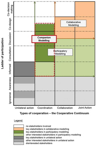
Basco-Carrera, Warren, van Beek, Jonoski, and Giardino (Citation2017) make a distinction between ‘Collaborative Modelling’ and ‘Participatory Modelling’ by considering levels of participation and type of cooperation as conditioning factors. At the core level, both participatory and collaborative modelling emphasize the importance of involving stakeholders in the modelling process. However, collaborative modelling is considered to comprise a subset and more intensive form of participatory modelling (). Participatory modelling is the starting context for the majority of ComMod applications due to the low level of cooperation among stakeholders. Generally, however, the initial conditions change with the support of ComMod. The type of cooperation, and as a result the level of participation, increase due to the development of a common understanding of the different systems and stakeholders by means of collaborative learning. A transformation can then occur from participatory modelling to collaborative modelling.
Figure 1. Classification of ComMod considering the various levels of participation and the types of cooperation (source: Basco-Carrera et al.Citation2017).
2.4.2 Specific use
ComMod is most suitable for supporting collective reflection and the integration of knowledge on different systems by settling existing disputes between stakeholders. The process can lead to collective action in the future (Étienne Citation2013; CIRAD Citation2015). The approach enhances stakeholders’ knowledge of the physical system and local mechanisms (i.e. behaviours, interactions and human-induced drivers) (Castella et al. Citation2005). The iterative process, composed of various loops and cycles, creates a sustained interaction environment between scientists and stakeholders (Olivier Barreteau et al. Citation2014) that facilitates this knowledge development through collaborative learning (Voinov and Bousquet Citation2010). A secondary output of a ComMod process is a common, accepted representation of the social and physical systems. The model(s) helps in evaluating the impacts of social mechanisms (e.g. stakeholder interactions, dynamics, resources) on the dynamics of natural resources. Although it is a secondary output, the co-construction of models is a critical element for collaborative learning, as it facilitates the modification of perceptions or behaviours via shared and social learning (Hare et al. Citation2003; Collins and Ison Citation2009; Evers et al. Citation2012).
The primary objective of this adapted ComMod approach consists of facilitating dialogue, enhancing the common understanding of complex river basins among governmental agencies and local stakeholders, and by doing so, resolve disputes. This first objective will ultimately lead to collective informed decision making for river basin planning and management.
Practically, ComMod can be applied in any stage of planning/management cycle. Olivier Barreteau et al. (Citation2014) exploration however shows that it is generally applied in the early stages of the integrated water resources planning and management cycle: (i) field work, (ii) modelling, (iii) simulation, (iv) field work (iterative process; CIRAD Citation2004; Étienne Citation2013). In particular, collective exploration and co-construction of the virtual world are the key moments. These findings are corroborated by our study. Nine out of ten analysed applications used ComMod at the preliminary stages (situation analysis, problem identification and strategies design).
2.4.3 Information handling
ComMod is based on developing a representation of the social system, based on a network of human agents, and the physical system by co-constructing models with stakeholders (Bousquet et al. Citation1999). It is a multi-agent systems (MAS)-based approach (Ruankaew et al. Citation2010), as it represents the social, biological and physical systems as well as their interactions. ComMod often combines the use of role-playing games (based on human agents) and an agent-based simulation model (based on computerized (virtual) agents). The use of one type or both depends on the different modelling phases (Olivier Janssen Citation2002; Barreteau et al. Citation2004; Boisseau Citation2005; Bousquet Citation2005; Castella et al. Citation2005; Souchère et al. Citation2010; Worrapimphong et al. Citation2010; CIRAD Citation2015). The information being handled relates to system interactions and relatively complex processes. According to Janssen (Citation2002), MAS-based approaches are particularly adapted to the representation of dynamic systems. However, the small scale in which ComMod is commonly applied and the stakeholders involved (and their interactions) are factors that condition the use of conceptual and simulation (empirical) models. The representation of the physical system are appropriate for collective action at small scale but frequently insufficient to be used in formal, informed decision making processes related to planning and policy making in larger scales.
The adapted approach presented in this article addresses this challenge. It is composed of three main elements as follows: (i) a complex computer-based simulation model(s), (ii) a role playing game and (iii) an agent-based model. The use of all elements or a combination of them can vary based on characteristics and conditions of each particular case. The main difference with the ‘common’ ComMod approach is the use of a complex simulation model(s) of the physical system (e.g. computer-based simulation models, numerical models – Section 5.5.1 (Basco-Carrera, et al., Citation2017)). Another important difference is its design. The construction of the virtual world for the role-playing game is based on the ‘real’ problems in the basin and potential interventions. The simplified rules and structure of the role-playing game help stakeholders to better understand the functioning of the ‘real’ system in an easy manner. Human agent interactions, dynamics and resources are analysed using the outcomes of the role playing game. Computer-based simulations are mainly used for providing more detailed information about the physical system. Merging both outputs helps in having a shared representation of the socio-physical systems and their interactions (Bousquet and Trébuil Citation2005).
2.4.4 Stakeholder engagement structure
ComMod follows the ARDI (Actors, Resources, Dynamics and Interactions) method to identify the principal groups of stakeholders that need to be engaged, their management and institutional structures, the resources used, and the processes that drive the changes that affect these resources (Etienne et al. Citation2011). Main protagonists include four categories: lay, researchers, technicians and institutional (Barreteau et al. Citation2014). These usually include grassroots organizations and groups (e.g. local communities, citizens), economic bodies (industries and companies), regional governments, academics and research institutions, and NGOs. Minimal skills and knowledge are listed in . ComMod facilitates the active engagement of these stakeholders from the early stages of the modelling process. Results from our exploration show that in all cases stakeholders were consulted or directly involved in the construction and use of all components of the ComMod setup. These findings are in line with the exploration of Barreteau et al. (Citation2014): the majority of case studies focused on the co-construction of the virtual world, its collective exploration and validation. The direct construction and manipulation of the role-playing game, makes participants as direct users. However, when more technically sophisticated modelling simulation tools are used, stakeholders (especially those from grassroots level) frequently become indirect users.
The common engagement structure in ComMod process is that all stakeholders have a similar level of participation. presents the most common levels of stakeholder participation in relation to the timing of participation. The flexibility of the approach however permits changes in levels of stakeholder involvement depending on the timing of participation. In river basins where a bottom-up planning and management process is followed, using a similar level of participation is encouraged. In large complex river basins, top-down approaches are more commonly used. Larger number of stakeholder groups need to be engaged to ensure collective action. The complexity of the institutional and political setup is high, with multiple agencies having similar responsibilities and power asymmetries. This, in combination with constraints in resources, encourages the design of more structured engagement processes (e.g. circles of influence approach) that support the negotiation process despite the differences in the levels of participation of stakeholders.
2.4.5 Modelling and organizing team
The neutrality of the established scientific and technical knowledge should not be compromised, as it serves as common ground for enhancing cooperation among stakeholders. The ethical framework (CIRAD Citation2004) helps tacking any possible subjectivity issue by stating that the modelling and organizing team composed of commodians, facilitators, technicians and scientists are obliged to take all identified stakeholders’ viewpoints into account equally, and to keep the process transparent.
Commodians are participatory modelling experts familiar with ComMod and are commonly responsible for the application of the approach. The organizing team can be composed of other stakeholders. Academics and researchers in the field of natural resources management can also be part of the team (Boisseau Citation2005; Faysse et al, Citation2007; Clavel et al., Citation2008). Stakeholders with political and economic knowledge of the system can also join the modelling and organizing team (Barreteau et al. Citation2003). Required modelling, facilitation, knowledge acquisition and process management skills are listed in .
3. Application of the adapted commod approach in turkey
3.1. Study area
In the European Union, river basin plans need to follow the European Water Framework Directive (WFD) (Directive 2000/60/EC). The WFD is the major driver for achieving sustainable water management. Its ultimate goal is the protection and improvement of inland, transitional and coastal water as well as groundwater. Public participation is considered as a critical supporting element for the achievement of the WFD objectives, as defined in Directive Article 14 on Public information and consultation (Parker et al. Citation2003; Van Ast and Boot Citation2003; Newig et al. Citation2005). A specific guideline has been developed for this purpose (Directive 2000/60/EC Guideline Document 8; European Communities (Citation2003)), providing insight on the stakeholder involvement process to leverage the success of the WFD by conceiving three forms of public participation: (i) information supply, (ii) consultation and (iii) active involvement (Castelletti and Soncini-Sessa Citation2006; De Stefano Citation2010).
In Turkey, IWRM has received increased attention in the last few years. The establishment of the Directorate General on Water Management and river basin management committees are some of the institutional measures recently implemented. River basin projects with stakeholder engagement have also increased. However, a strongly centralized institutional setup and rivalry between agencies due to similar responsibilities and power asymmetries (i.e. competitive interaction context) are major institutional issues. Moreover, the lack of legislation on stakeholder engagement in water management combined with receiving criticism and rejection of their policies and planning mechanisms raises major concerns among decision makers. They prefer to limit the involvement of local stakeholders to general public consultations.
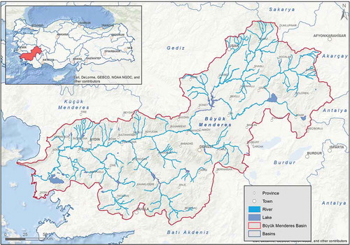
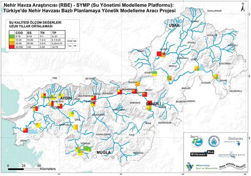
The Büyük Menderes river basin is located in the south-western part of Turkey and has an area of 24873 km2 (). The population was 2.5 million in 2000 and it is expected to increase to 4.9 million by 2020. The river originates as a spring from limestone deposits and in conjunction with other tributaries it becomes the Büyük Menderes river at the basin lowlands. It then discharges into the Aegean Sea. The climate in the basin varies from continental climate in the upstream area to Mediterranean climate downstream. The average rainfall is 635 mm/year. Water quality is subject to the WFD guidelines. Its main objectives are to (i) maintain ‘high status’ of waters where existing, (ii) prevent any deterioration in the existing status of waters; and, (iii) achieve ‘good status’ in all waters. According to the River Basin Management Plan for Büyük Menderes river basin (European Commission Citation2010), the water quality of the majority of water bodies is moderate or poor. Industrial waste disposals are the main point source pressures. Agriculture and mining activities as well as urban runoff form the main sources of diffuse pollution (Koç Citation2010). Flow regulation (i.e. environmental flows) and physical barriers are the most notable hydro-morphological pressures. In addition, data scarcity is a major problem, as it results in high uncertainty about the physical system and its functioning. Interventions and strategies designed in this study should therefore be evidence-based solutions that help reaching these water quality and ecology objectives.
Figure 2. The Büyük Menderes river basin in Turkey (source basemap: ESRI Citation2009).
3.2. Adapted companion modelling approach
The main objective of applying an adapted ComMod approach was to facilitate dialogue and settling existing disputes by enhancing a common understanding of the complex river basin among governmental agencies and local stakeholders. For this, the approach combined the use of two simulation models and a role-playing game (Section 3.2.3). The approach helped in:
Raising awareness and developing a common understanding of how to manage the river basin in a sustainable and inclusive manner via stakeholder workshops and capacity development sessions;
Joint identification of main issues related to river basin management in the basin, and formulation of potential interventions and strategies;
Co-designing a user-friendly but complex computer-based simulation model to analyse the water availability and water quality in the basin;
Testing possible cost-effective interventions and strategies under different scenario conditions;
Structuring the stakeholder engagement process, mediating between parties and supporting the negotiation of commonly agreed interventions.
3.2.1. Project organization and means
The project lasted 16 months. It started in September 2014 and finalized in December 2015. The modelling team included two local modelling teams focusing on hydrology and ecology () and an international modelling team composed of Witteveen+Bos and DeltaresFootnote1 technical experts. The organizing and facilitation team was composed of a commodian (from Deltares), two experts in the Water Framework Directive and river basin management (from Deltares and a Dutch water board) and a local team composed of members of the Directorate General on Water Management Modelling Section and the Nature Conservation Centre NGO. The involvement of NGOs as part of the organizing team helped the modelling team to receive continuous support in understanding of the local environment, as the majority of NGO staff has considerable local and technical knowledge on natural resources management. Moreover, they commonly understand and support the interests of local communities. This helped ensuring that all identified stakeholders’ viewpoints were taken into account equally. Finally, local NGOs helped in reducing cultural barriers between the modelling team, commodians and the local stakeholders (e.g. communication – language-, session protocols). It was critical for them to keep their neutral position throughout the process by following the ethical framework (CIRAD Citation2004).
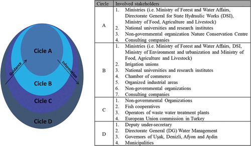
Figure 3. Circles of influence structure for Büyük Menderes river basin.
3.2.2. Stakeholder engagement structure
A stakeholder engagement structure was designed to ensure fruitful stakeholder participation in the modelling process. The ARDI method was followed to identify the groups of stakeholders that needed to be involved in the study and analyse their interactions, key resources, dynamics as well as their capacity to modify the processes (Etienne et al. Citation2011). Information obtained from individual interviews and focus group discussions served as input for the design of the engagement process. Other key points of interest for the design included the participatory planning and institutional setup in Turkey, as well as the data, modelling tools and financial mechanisms used for implementation.
The 146 stakeholder representatives were engaged considering the circles of influence approach, developed by US Army Corps of Engineers (Cardwell et al. Citation2008). Four levels of influence were used in the Büyük Menderes case: (i) Circle A: model construction team, (ii) Circle B: model users and validation team, (iii) Circle C: other interested stakeholders and (iv) Circle D: decision makers (). The level of involvement of each circle was decided considering the contextual type of cooperation in the project (Hurlbert and Gupta Citation2015; Basco-Carrera et al. Citation2017).
The participatory modelling process was designed based on the stakeholder engagement structure ( and ). It included a kick-off, mid-term and closure meetings combined with regular consultation meetings with decision makers and local stakeholders. A capacity building session on water resources management and participatory modelling was organized. Moreover, four participatory modelling sessions were conducted: three for model construction and one for model use. The process followed simple and double loops of individual and collective learning (Étienne Citation2013).
Figure 4. Modelling approach (source: Deltares Citation2016b). The order of the tasks is indicated by the numbering within the red circles.
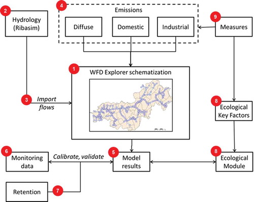
Figure 5. Examples of measure cards (adapted from: Valkering et al. Citation2013; Van Pelt et al. Citation2015; Lawrence and Haasnoot Citation2017).
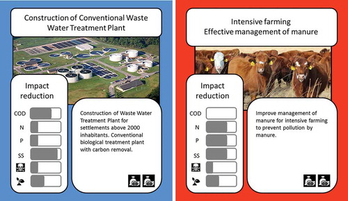
Figure 6. Extract of diagram of interactions.
3.2.3. Modelling approach
The participatory modelling approach for the Büyük Menderes basin incorporated two simulation modelling suites and a role playing game.
3.2.3.1. Computer-based simulation models
The Büyük Menderes study comprised two modelling suites, i.e. RIBASIM and WFD Explorer, using three functional modules: (i) hydrology and water distribution using RIBASIM, (ii) water quality using DELWAQ, and (iii) ecology using Product Unit Neural Network (PUNN) ().
The River Basin Simulation model package, RIBASIM, is a decision support tool for multi-sector planning to allocate scarce resources at the river basin level (van der Krogt and Boccalon Citation2013). The model represents the hydrological situation of the Büyük Menderes on catchment scale, including reservoir operation, river runoff, urban water fluxes and water use by crops. It also enables the screening of possible measures related to infrastructure, operational and demand management and testing of alternative future strategies. The RIBASIM model for the Büyük Menderes study was used for modelling the hydrological relations in which water allocation was simulated. It was constructed with historical data from 2003 to 2011 with a monthly time step. Hydrological data was based on observed discharges. For those non-measured basins, the hydrological data was extrapolated by using the run-off depth of similar neighbouring catchments. A total of six main cities and organized industrial areas were considered for the study of Domestic, Municipal and Industrial water demands. Likewise, 34 irrigation schemes were represented. Existing storage facilities such as weirs and reservoirs were also included in the model, as well as the corresponding environmental flows.
The WFD Explorer is an analysis tool to support the implementation of the Water Framework Directive. It is a modular toolbox that incorporates hydrology, water quality, emissions and ecology (Wortelboer et al. Citation2015). This modelling structure permits the calculation of the effect of restoration and mitigation measures on the chemical and ecological quality of surface waters (Mouton et al. Citation2009). Decision makers and stakeholders can then assess how effective the potential measures are in reaching the WFD objectives. The WFD Explorer 2.0 was used for water quality assessment in Büyük Menderes basin. A DELWAQ model was used for water quality modelling (i.e. D-Water quality and D-Ecology of the Delft3D suite) and a PUNN model for ecology. The DELWAQ model covered basic tracers, dissolved oxygen, nutrients, organic matter, inorganic suspended matter, heavy metals, bacteria and organic micro-pollutants (Deltares Citation2016a). Ecological knowledge captured in rules was simulated using the PUNN method. This method is based on the linkage between ecological steering factors and the Ecological Quality Ratio (EQR) (De Niet et al. Citation2014). The WFD Explorer schematization included 67 sub-catchment areas and 266 explicitly modelled surface water nodes. Water fluxes driving the transport of nutrients and COD in the water quality model were derived from RIBASIM. Water fluxes were available for the period October 2003 till September 2011. Based on these results, three-monthly averaged water balances were compiled and used in WFD Explorer. The model was calibrated for three water quality parameters; tot-N, tot-P and COD on 12 monitoring stations. The most recent complete year (2010) was used for calibration of the model. The calibration procedure consisted of a four-step routine. The routine started with performing minor adjustments to the RIBASIM model, including the addition of minimal environmental flows. Hydrological patterns were added to the release of nutrients from the diffuse sources. This second step was followed by adding a first order decay process to the model. The process caused the removal or decrease of COD, Tot-N, Tot-P due to hydraulic residence time.
3.2.3.2. Role-playing game
A role playing game was co-designed and used for the formulation of potential interventions and design of potential strategies. The main objectives of the game were to: (i) understand stakeholders’ perceptions, behaviours, interactions and dynamics, (ii) facilitate the exchange of points of view, knowledge and experiences, and initiate collective learning, and (iii) build trust and ownership of the simulation models and designed strategies (Eden and Ackermann Citation2013).
The reality conditions (i.e. context and application) defined the game setting. This comprised four main elements: environmental setting, players, rules of operations and input to the game. The environmental information on water availability and quality was extracted from RIBASIM and WFD Explorer, respectively. It included the ‘real’ problems in Büyük Menderes river basin and the potential interventions (see supplementary material online). three maps, 24 measure cards, a computer, a projector, stickers and markers were used as communication and visualization tools. The maps illustrated the RIBASIM schematization and the water quality status of Büyük Menderes river basin. The design of the measure cards followed Bots et al. (Citation2011) information-transparency rules. Key elements of the cards included: name of the intervention, brief description, estimation of cost (i.e. high, moderate, low) and impact reduction (as percentage) of COD, Suspended Solids, Tot-N, Tot-P, toxics and ecology. The measures were categorized into structural measures for addressing point or diffuse sources, ecological measures, institutional arrangements and soft measures such as capacity building. Each category was represented by a different card colour ().
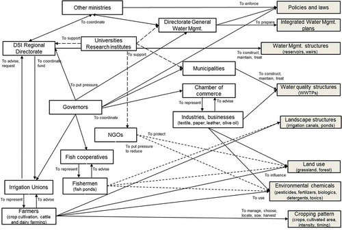
The physical and social systems were connected by players (stakeholders) and their roles. The ‘real’ roles and dynamics of the different groups of stakeholders were maintained, as the game aimed to represent the ‘real’ systems as much as possible. shows the diagram of interactions. Interactions between stakeholders (white boxes) and resources (grey boxes), or among stakeholders, are represented with arrows. Arrows are associated with actions. The real roles and dynamics were also reflected in the rules of the game. These reflected the institutional setup and legitimate procedures for water resources planning and implementation in Turkey. Participants were divided into small groups. The participation mode varied in the focus groups. During the first focus group, participants were divided into three homogeneous groups composed of stakeholders with similar roles, values and interests. During the second round, participants were grouped in two heterogeneous groups. In the group they could decide to actively intervene by being involved in proposing potential interventions and their location using the measure cards or have a passive attitude. Each group could only select two measure cards as part of the preferred strategy. The final negotiation of the preferred strategy was performed by a representative of each group. Support by an academic or technician could be asked if additional technical and scientific knowledge was needed during the decision making process.
3.3. Evaluation process
An evaluation of the model results relevant to participatory research of using ComMod was performed. Three mechanisms were used for gathering data in the study: (i) project documents, (ii) semi-structured interviews, and (iii) focus groups. Two focus groups were used to challenge data previously collected via face-to-face interviews on water resources management policies, planning and implementation. It was also used to evaluate group dynamics (e.g. group norms, language, interactions and narratives) (Gill et al. Citation2008). The three main questions asked are: (i) what are the key water management issues your organization is facing as well as the successes and future needs in terms of IWRM implementation and stakeholder engagement? (ii) how can modelling tools, such as RIBASIM and the River Basin Explorer, support you addressing these issues and needs? and (iii) how can the combination of modelling tools and local knowledge support the management of water related issues in the Büyük Menderes River Basin? Some post-interviews with decision makers and investment banks were conducted after the focus groups to clarify some of the data. The data collected served for designing the participatory modelling approach and adapt it to the local conditions.
4. Results and discussion
4.1. Creating an enabling environment
The interactive setup of the stakeholder sessions surprised the majority of stakeholders, as they were expecting the commonly used formal meetings. Decision makers had serious concerns regarding the active involvement of local stakeholders in the modelling and planning processes, due to the frequent criticism and rejection received on their policies. They initially disapproved having NGOs as part of the organizing team. Moreover, the use of role-playing games in formal planning and management processes was not well perceived. The approach got finally accepted after a 2-month negotiation process between decision makers and the organizing team. It was agreed that a pacification strategy (Hanssen et al. Citation2009) would be followed: uncertainties about the socio-physical system would be first reduced, and the shared understanding about the system would be then used to reach consensus among stakeholders. In practice, the co-construction process with Circle A stakeholders prior to the role-playing game sessions was critical for ensuring that the model was trusted by the national authorities and therefore more interactive sessions with local stakeholders could be held.
4.2. Accepted representation of the real system
The competitive environment in Turkey, in which certain governmental authorities and stakeholders have similar responsibilities, creates tensions and leads to unilateral action. Disputes also occur due to disagreements regarding values, norms and standards or perceptions of the water resources system in Büyük Menderes river basin. The establishment of a common ground accepted by all involved stakeholders was a critical first step in the negotiation process. The adapted ComMod approach was used to enhance multi-stakeholder cooperation between national and regional stakeholders, and between sectors and disciplines by means of non-strategic scientific support. Having independent technicians and scientists in the organizing team and the co-development of ‘complex’ simulation models with stakeholders helped in raising their acceptance of the scientific support received. However, having an agreed representation of the real socio-physical system was essential for creating a common ground. The models and their outputs needed to be considered by all stakeholders as being neutral. The role-playing game needed to be accepted as a tool that can be used in formal decision making processes. A comparison between the results of the empirical models (i.e. RIBASIM and WFD Explorer) and the mental models of the national and regional stakeholders was thus required. The model outputs showed that the water quality status, considering COD, suspended solids, Tot-N and Tot-P, is particularly ‘bad’ downstream and in urban and industrial areas (e.g. Denizli) (). This assessment was in line with the exploration of the national stakeholders. These results can be understood by the fact that the majority of them had been involved in the construction of the quantitative model. More variation could be observed between the mental models of the regional stakeholders and the results the WFD Explorer model regarding the principal physical issues in the basin. All expressed water stress and poor water quality as the principal physical issues. However, the specific issues, including their geo-spatial location, pressures and environmental impacts were barely known. Two small group facilitators from Nature Conservation Centre recognized the benefits of using maps to display the outputs of the WFD Explorer during the discussions. National and regional stakeholders collaborated to understand the pressures in each region and the impacts in terms of water availability and quality. For instance, industrial effluents combined with inadequate consideration of environmental flow requirements were identified as major pollution pressures in Denizli and downstream areas (e.g. Kuyucak, Buharken). The bad practices of farmers regarding management of manure, use of fertilizers and pesticides also exacerbates water pollution downstream Denizli and Aydin.
Figure 7. Water quality status for Büyük Menderes river basin obtained from WFD Explorer.
After the creation of a general consensus regarding the water quality status in the Büyük Menderes river basin, stakeholders collaborated in the validation of the WFD explorer model and the formulation of possible future improvements. This step was particularly important to commence a collaborative attitude among stakeholders. Possible future improvements that were identified include: (i) collection of more continuous data sets at the same location and by better validating data for improving the quality of discharge monitoring, (ii) addition of data on irrigation areas, hydropower generation and demand, and domestic water demand and supply, (iii) collection of ‘updated’ reservoir operation rules, as well as, (iv) collect data on monthly inflow, outflow and levels of all reservoirs. The evaluation of the negotiation process shows that all 59 stakeholders (i.e. Circle B) felt confident that their knowledge was taken into account for the construction and validation of the models. They indicated that the open and transparent process helped in building trust towards the data, models used and in creating an agreed representation of the real system. Particularly regional stakeholders recognized that the adapted ComMod approach helped them to get a better insight in the functioning of the river basin.
4.3. Shared understanding of the social and institutional dimension
Understanding the social and institutional dimension was essential for the creation of the enabling conditions and a common ground for cooperation, and as a result the role-playing game. This was done during the capacity development session where stakeholders were asked to jointly explore the successes, limitations and needs of the social and institutional aspects of IWRM in Turkey. Key was the division of participants in heterogeneous small groups, as it facilitated their knowledge exchange and interaction. The organizing team recognized that such cooperation could not have been achieved without having ensured first a shared understanding of the physical system (i.e. pacification strategy).
Stakeholders from Circles A and B identified limiting factors that have a direct effect on the physical issues. The lack of qualified personnel that knows how to use modelling and socio-economic impact assessment tools in the national and regional levels is a key challenge. The Directorate General on Water Management and other ministries recognized that the national funds allocated to IWRM and the access to international financial mechanisms has increased in the last decade. However, the lack of evidence-based solutions and investment plans slows the implementation process. Bad water governance characterized by insufficient cooperation among institutions and stakeholders also hampers the decision making process. Finally, stakeholders from Circles A and B recognized the important role that local stakeholders have in the implementation and O&M of measures to ensure their sustainability. However, the lack of support, national stakeholder engagement protocols and limited technical knowledge in the basin are main shortcomings. Sometimes the lack of commitment of local stakeholders translates into their non-continuous involvement or reduction of their involvement throughout the project. This statement was contested by local stakeholders. They argued that often they are barely involved. They are only informed or consulted when the national stakeholders consider it necessary.
4.4. Collective negotiation agreement of a water quality strategy
The impact of applying ComMod in comparison with a pure traditional top-down planning approach is reflected in the formulation of measures by decision makers and stakeholders. While traditionally a large portion of both national and regional funds was allocated to infrastructural projects, the proposed interventions are a combination of infrastructural, soft and institutional measures. The negotiation process for selecting potential measures during the role-playing game followed four cyclical steps, as follows: (i) prioritization of three main challenges related to the water status in Büyük Menderes river basin, (ii) definition of main ambitions and goals, (iii) selection of two potential measures and (iv) impact assessment using WFD Explorer.
For the collective formulation and selection of measures, stakeholders worked in small homogeneous small groups for the upstream region of Büyük Menderes river basin. These were then merged into heterogeneous groups for the downstream region. Each small group had the freedom to define their own goals and preferences on which they were choosing the proposed measures. No significant variations appeared in the identification of main issues and challenges across groups. The use of homogeneous and heterogeneous groups also did not have a significant influence. This agreement shows the benefits of the prior step to create a common ground. As a result, there was a cooperative environment in the next step, the selection of potential measures. For the upstream region, all small groups selected a combination of infrastructural and soft measures. Particularly, all groups selected the construction of a WWTP. Differences appeared in the selection of the soft measure. The group composed of representatives from the national government did not follow the rules of the game, and selected two soft measures (three measures in total). However, the other groups did not complain. The selected measures included the enforcement of improved management of manure and training for farmers on good agricultural practices. The other two small groups composed mainly by representatives of regional stakeholders selected the treatment of drainage water of farming and agriculture and training on clean production technologies in textile factories. The commodian asked then a representative of each small group to form a temporary multi-stakeholder advisory committee and negotiate a preferred strategy composed of three measures. The committee had 10 min to negotiate. No agreement could be reached after the designated time. It was then agreed that another 10 min would be added to the negotiation process. The commission did not follow the rules of the game. They decided to select another measure that had not been previously selected by the small groups: Training for farmers on good agricultural practices. Moreover, they could not agree in the selection of only three measures. As a result, the preferred strategy for the upstream region is composed of four measures. In the application of the role-playing game for the downstream region in heterogeneous groups differences in dependencies and hierarchical relations became more apparent. The representatives of the national stakeholders assumed a leading role. The involvement of the irrigation unions and fish cooperatives reduced gradually. The final negotiation for the preferred strategy was held by a representative of the DSI Regional Directorate () and of a local university. In this case, an agreement could be reached in the established time (10 min). The resulting strategy comprised also a combination of an infrastructural and a soft measure: construction of an advanced WWTP in an industrial area, and the reallocation of the olive oil industry into an industrial zone with a WWTP.
5. Conclusions
The SDGs, especially SDG6, highlight the implementation of IWRM at all levels to ensure access to water and sanitation for all. The combination of expert-based knowledge and tools, and local knowledge and practices via multi-stakeholder partnerships are important elements for their achievement. In this article, we have demonstrated the appropriateness of an adapted participatory modelling approach that combines the key features of ComMod and simulation modelling. The approach addresses primary causes that limit the acceptance and practical implementation of IWRM plans, and as a result sustainable development: lack of knowledge about the water resources system and disagreements between water users. The continuous involvement of stakeholders in the modelling process supports the creation of a common understanding of the river basin system (collaborative learning), which ultimately can lead to collective design of a water management strategy. The co-construction and use of simulation models for the physical system in combination with role-playing games helps in building trust of the simulation models and the results, and in understanding the interaction and dynamics among stakeholders. This is particularly critical for creating a common ground for the negotiation process. Moreover, the structured stakeholder engagement structure and the use of modelling and communication tools help enhancing multi-stakeholder collaboration. Cooperation among participants increases as they gradually learn about the perceptions, behaviours, positions, interests of other stakeholders.
The development of the adapted participatory modelling approach followed an iterative process of analysing the key features of the ComMod approach when applied to water resources management and an exploration of ten cases using six parameters (i.e. context and application, specific use, information handling, stakeholder involvement structure, organizing team and means). The approach was tested in a top-down planning process in Turkey. The application of the adapted ComMod approach shows promising results in terms of the three IWRM pillars for sustainable development: supporting the creation of an enabling environment, better understanding of the institutional system, and the development and acceptance of new tools for managing water quality. In the Turkish case, the process also resulted into a set of potential interventions collectively formulated and their impacts analysed using the simulation models (i.e. RIBASIM and WFD Explorer). In particular, the construction of WWTPs in combination with technical trainings and institutional measures are the most accepted solutions for achieving water security and sustainable development in the basin. More detailed technical and investments analysis is however expected.
Supplemental data for this article can be accessed here
Supplementary_material.docx
Download MS Word (14.8 KB)Acknowledgments
We acknowledge the financial support provided by Partners for Water Programme in the Netherlands, the Ministry of Forestry and Water Affairs in Turkey and Deltares. Special appreciation is due to Directorate General on Water Management from The Ministry of Forestry and Water Affairs, especially to the modelling section. We would also like to express our sincere gratitude to Yu Yangyue and all stakeholders who contributed to this study. Last but not least, we are thankful for the support of Cliford Apuh Ntongwe as editor.
Disclosure statement
No potential conflict of interest was reported by the authors.
Additional information
Funding
Notes
1. Witteveen+Bos is a Dutch engineering consultancy specialized in deltas, coasts and rivers, infrastructure, energy, water and environment as well as in built environments (www.witteveenbos.com).
Deltares is a non-for-profit independent Dutch institute for applied research in the field of water and subsurface. Its areas of expertise are: flood risk, adaptive delta planning, infrastructure, water and subsoil resources and environment (www.deltares.nl).
Related Research Data
References
- Barreteau O, Bousquet F. 1999. Jeux de rôles et validation de systèmes multi-agents. JFIADSMA. Ingéniere des systèmes multi-agents. Hermes Sci Publ. 99(1):67–80.
- Barreteau O, Bousquet F, Étienne M, Souchère V, d’Aquino P. 2014. Companion modelling: a method of adaptive and participatory research. Companion Modell. 13–40. Springer. doi: 10.1007/978-94-017-8557-0_2
- Barreteau O, Bousquet F, Millier C, Weber J. 2004. Suitability of multi-agent simulations to study irrigated system viability: application to case studies in the Senegal River Valley. Agric Syst. 80(3):255–275.
- Barreteau O, Bousquet F, Weber J. 1997. Modes de gestion et viabilité des périmètres irrigués: questions de représentation. In: Weill FB, editors. Tendances nouvelles en modélisation pour l’environnement. Paris: Elsevier; p. 153–159.
- Barreteau O, Garin P, Dumontier A, Abrami G, Cernesson F. 2003. Agent-based facilitation of water allocation: case study in the Drome River Valley. Group Dec Negot. 12(5):441–461.
- Basco-Carrera L, Warren A, van Beek E, Jonoski A, Giardino A. 2017. Collaborative modelling or participatory modelling? A framework for water resources management. Environ Modell Software J. 91:95–110.
- Biswas AK. 2004. Integrated water resources management: a reassessment: a water forum contribution. Water Int. 29(2):248–256.
- Boisseau S. 2005. Co-evolution of a research question and methodological development: an example of companion modeling in northern Vietnam. In: Bousquet F, Trébuil G, Hardy B (editors). Companion modeling and multi-agent systems for integrated natural resource management in Asia. Los Baños (Philippines): International Rice Research Institute. 360 p.
- Bots PW, Bijlsma R, von Korff Y, van der Fluit N, Wolters H. 2011. Supporting the constructive use of existing hydrological models in participatory settings: a set of “rules of the game”. Ecol Soc. 16(2):19.
- Bousquet F, Trébuil G, Hardy B, editors. 2005. Companion modeling and multi-agent systems for integrated natural resource management in Asia. Los Baños (Philippines): International Rice Research Institute. 360 p.
- Bousquet F, Barreteau O, Le Page C, Mullon C, Weber J. 1999. An environmental modelling approach: the use of multi-agent simulations. Adv Environ Ecol Modell. 113:122.
- Bousquet F, Trébuil G. 2005. Introduction to companion modeling and multi-agent systems for integrated natural resource management in Asia. Companion modeling and multi-Agent systems for integrated natural resource management in Asia. Los Baños (Philippines): International Rice Research Institute. 1–20.
- Cardwell H, Langsdale S, Stephenson K. 2008. The shared vision planning primer: how to incorporate computer aided dispute resolution in water resources planning. Institute for Water Resources, Alexandria, IWR Report.
- Castella J-C, Trung TN, Boissau S. 2005. Participatory simulation of land-use changes in the northern mountains of Vietnam: the combined use of an agent-based model, a role-playing game, and a geographic information system. Ecol Soc. 10(1):27.
- Castelletti A, Soncini-Sessa R. 2006. A procedural approach to strengthening integration and participation in water resource planning. Environ Modell Software. 21(10):1455–1470.
- CIRAD. 2004. [accessed 2016 March]. http://cormas.cirad.fr/ComMod/en/.
- CIRAD. 2015. [accessed 2016 January]. www.commod.org/en/.
- Clavel L, Ducrot R, Sendacz S. 2008. Gaming with eutrophication: contribution to integrating water quantity and quality management at catchment level. IWRA, 13ème congrès mondial de l’eau; Montpellier. 2008(1-4).
- Collins K, Ison R. 2009. Jumping off Arnstein’s ladder: social learning as a new policy paradigm for climate change adaptation. Environ Policy Govern. 19(6):358–373.
- De Niet A, Meijers E, Schep S. 2014. Accurate prediction of ecological quality ratio with product unit neural networks. 11th International Conference on Hydroinformatics HIC 2014; New York City, USA.
- De Stefano L. 2010. Facing the water framework directive challenges: a baseline of stakeholder participation in the European Union. J Environ Manage. 91(6):1332–1340.
- Deltares. 2016a. DELWAQ. [accessed 2016 January]. http://oss.deltares.nl/web/delft3d/delwaq.
- Deltares. 2016b. Final report river basin explorer: a modelling tool for River Basin planning in Turkey. The Netherlands: Deltares, Witteveen+Bos, Regional Water Authority Peel and Maasvallei and DKM.
- Ducrot R, Chagas de Carvalho YM, Jacobi PR, Clavel L, Barban V, Madazio V., Rabak C, Reydon BP, Bussmeyer Arruda F, Ramos HH, et al. 2007. Building capacities to tackle the infrastructural and environmental crisis in São Paulo: role-playing games for participatory modelling. In: Butterworth, J., Ducrot, R., Faysse, N., Janakarajan, et al. Peri-urban water conflicts–supporting dialogue and negotiation (Technical Paper Series, 50). Delft : IRC International Water and Sanitation Centre, p. 77-112.
- Eden C, Ackermann F. 2013. Making strategy: the journey of strategic management. Great Britain: Sage.
- ESRI. 2009). World terrain base. Retrieved 2016 May 4 from http://services.arcgisonline.com/ArcGIS/services/World_Terrain_Base/MapServer?wsdl
- Étienne M. 2013. Companion modelling: a participatory approach to support sustainable development. Netherlands: Springer Science & Business Media. doi:10.1007/978-94-017-8557-0
- Etienne M, Du Toit D, Pollard S. 2011. ARDI: a co-construction method for participatory modeling in natural resources management. Ecol Soc. 16(1):44.
- European Commission. 2010. Büyük Menderes River Basin Management plan. Republic of Turkey Ministry of Environment and Forestry, Directorate General for State Hydraulic Works in cooperation with Dutch DLG Government Service for Land and Water Management, UK Environment Agency and the Slovak Water Research Institute.
- European Communities. 2003. Public participation in relation to the water framework directive. Common implementation strategy for the water framework directive (2000/60/EC). Guidance Document 8. Luxembourg: Office for Official Publications of the European Communities..
- Evers M., Jonoski A., Maksimovič Č., Lange L., Ochoa Rodriguez S., Teklesadik A., Cortes Arevalo J, Almoradie A, Eduardo Sim~oes N, Wang L. 2012. Collaborative modelling for active involvement of stakeholders in urban flood risk management. Nat Hazards Earth Syst Sci. 12(9):2821–2842. https://www.nat-hazards-earth-syst-sci.net/12/2821/2012/nhess-12-2821-2012.html
- Farolfi S, Müller J-P, Bonté B. 2010. An iterative construction of multi-agent models to represent water supply and demand dynamics at the catchment level. Environ Modell Software. 25(10):1130–1148.
- Faysse, N., Bustamante, R., Del Prado, A.D.N., Cuba, P., Alcoba, R.G.A., Rojas, V.C., Terrazas JAI, Lizárraga A, Paz Betancourt B, Caprirolo RGP, et al. 2007. Supporting local organisations in peri-urban Cochabamba, Bolivia. In: Butterworth J, Ducrot R, Faysse N, and Janakarajan S (editors). Peri-Urban Water Conflicts: Supporting dialogue and negotiation. Delft, the Netherlands, IRC International Water and Sanitation Centre (Technical Paper Series; no 50). 128 p.
- Fung A. 2006. Varieties of participation in complex governance. Public Adm Rev. 66(s1):66–75.
- Gill P, Stewart K, Treasure E, Chadwick B. 2008. Methods of data collection in qualitative research: interviews and focus groups. Br Dent J. 204(6):291–295.
- Gurung T, Bousquet F, Trébuil G. 2006. Companion modeling, conflict resolution, and institution building: sharing irrigation water in the Lingmuteychu Watershed, Bhutan. Ecol Soc. 11(2):36.
- GWP. 2000. Integrated water resources management TAC background papers. Sweden: Global Water Partnership (GWP). Vol. 4.
- Hanssen L, Rouwette E, van Katwijk MM. 2009. The role of ecological science in environmental policy making: from a pacification toward a facilitation strategy. Ecol Soc. 14(1):43.
- Hare M, Letcher R, Jakeman A. 2003. Participatory modelling in natural resource management: a comparison of four case studies. Integr Assess. 4(2):62–72.
- Hurlbert M, Gupta J. 2015. The split ladder of participation: A diagnostic, strategic, and evaluation tool to assess when participation is necessary. Environ Sci Policy. 50:100–113.
- Janssen M. 2002. Complexity and ecosystem management: the theory and practice of multi-agent systems. UK: Edward Elgar Publishing.
- Koç C. 2010. A study on the pollution and water quality modeling of the River Büyük Menderes, Turkey. Clean–Soil Air Water. 38(12):1169–1176.
- Lawrence J, Haasnoot M. 2017. What it took to catalyse uptake of dynamic adaptive pathways planning to address climate change uncertainty. Environ Sci Policy. 68:47–57.
- Mouton AM, Van Der Most H, Jeuken A, Goethals PL, De Pauw N. 2009. Evaluation of river basin restoration options by the application of the water framework directive explorer in the Zwalm River basin (Flanders, Belgium). River Res Appl. 25(1):82–97.
- Newig J, Pahl‐Wostl C, Sigel K. 2005. The role of public participation in managing uncertainty in the implementation of the water framework directive. Eur Environ. 15(6):333–343.
- Parker DC, Manson SM, Janssen MA, Hoffmann MJ, Deadman P. 2003. Multi-agent systems for the simulation of land-use and land-cover change: a review. Ann Association Am Geographers. 93(2):314–337.
- Ruankaew, N., Le Page, C., Dumrongrojwattana, P., Barnaud, C., Gajaseni, N., van Paassen, A., Trébuil G. 2010. Companion modelling for integrated renewable resource management: a new collaborative approach to create common values for sustainable development. Int J Sustainable Dev World Ecol. 17(1):15–23. doi: 10.1080/13504500903481474
- Souchère V, Millair L, Echeverria J, Bousquet F, Le Page C, Etienne M. 2010. Co-constructing with stakeholders a role-playing game to initiate collective management of erosive runoff risks at the watershed scale. Environ Modell Software. 25(11):1359–1370.
- United Nations. (2016). Sustainable delvelopment goals. [accessed 2016 October] www.un.org/sustainabledevelopment/.
- Valkering P, van der Brugge R, Offermans A, Haasnoot M, Vreugdenhil H. 2013. A perspective-based simulation game to explore future pathways of a water-society system under climate change. Simul Gaming. 44(2–3):366–390.
- van Ast J, Boot SP. 2003. Participation in European water policy. Phys Chem Earth Part A/B/C. 28(12–13):555–562.
- Van der Krogt WNM, Boccalon A. 2013. River basin simulation model RIBASIM version 7.00. User manual. Deft: Deltares. Deltares report 1000408-002.
- van Pelt S, Haasnoot M, Arts B, Ludwig F, Swart R, Biesbroek R. 2015. Communicating climate (change) uncertainties: simulation games as boundary objects. Environ Sci Policy. 45:41–52.
- Voinov A, Bousquet F. 2010. Modelling with stakeholders. Environ Modell Software. 25(11):1268–1281.
- Wolf AT, Yoffe SB, Giordano M. 2003. International waters: identifying basins at risk. Water Policy. 5(1):29–60.
- Worrapimphong K, Gajaseni N, Le Page C, Bousquet F. 2010. A companion modeling approach applied to fishery management. Environ Modell Software. 25(11):1334–1344.
- Wortelboer FG, Van De Roovaart JC, Karaaslan Y, Çankaya MEB. 2015. Models for the water framework directive–using RIBASIM and WFD explorer. In Sustainable Watershed Management: SuWaMa 2014 conference proceedings; CRC Press. US: Taylor & Francis Group.
- Zeitoun M, Mirumachi N. 2008. Transboundary water interaction I: reconsidering conflict and cooperation. Int Environ Agreements: Politics, Law Econ. 8(4):297–316.